1
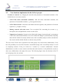
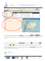
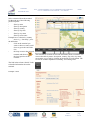
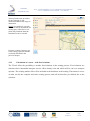
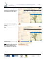
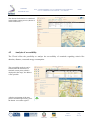
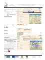
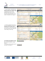
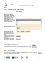
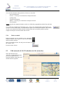
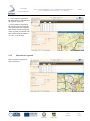
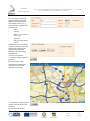
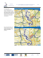
1CE055P2 - SoNorA A.5.6 – ICT development: – User manual O.5.6.4 evaluation tool for nodes and O.5.6.5 evaluation tool for network Work Package WP 5 – Activating services along itineraries Action A5.6 – ICT development nodes Author PP 24 – Technical university of applied sciences Wildau Version 1 Date 03.05.2011 Status Final 1CE055P2 South North Axis A5.6 – ICT development: O.5.6.4 evaluation tool for nodes and O.5.6.5 evaluation tool for network – User manual Public Document Approval Chronology Document Revision / Approval Version Date Status Date Status 1 03.05.2011 Draft 25.05.2011 LP Approved Final 03/05/11 page 2 / 47 1CE055P2 South North Axis A5.6 – ICT development: O.5.6.4 evaluation tool for nodes and O.5.6.5 evaluation tool for network – User manual Public Index 1 2 2.1 2.2 3 4 4.1 4.1.1 4.1.2 4.2 5 5.1 5.2 5.2.1 5.2.2 5.2.3 5.2.4 5.3 5.3.1 5.3.2 5.3.3 5.3.4 5.3.5 5.4 6 6.1 6.2 6.3 6.3.1 6.3.2 7 7.1 7.2 Table of definitions ......................................................................................................................4 Introduction of the tool................................................................................................................5 Basic functions .............................................................................................................................. 5 New functions implemented in the SoNorA project ..................................................................... 6 Access to the tool ..........................................................................................................................7 Basic functions – available for all users ...................................................................................10 Intermodal routing ...................................................................................................................... 10 Calculation of a route – without fixed relations ......................................................................... 10 Calculation of a route – with fixed relations............................................................................... 17 Analysis of accessibility ............................................................................................................. 20 Creation of scenarios – available for scenario administrators ..............................................22 Basic information for working with a scenario .......................................................................... 22 Edit nodes (O.5.6.4 Evaluation tool for nodes) .......................................................................... 24 Select a network segment ........................................................................................................... 24 Edit terminal information and parameters .................................................................................. 25 Add new terminal........................................................................................................................ 29 Delete terminal ............................................................................................................................ 30 Edit network (O.5.6.5 Evaluation tool for networks) ................................................................. 30 Select a network segment ........................................................................................................... 31 Edit network segment ................................................................................................................. 32 Add new network segment ......................................................................................................... 37 Delete network segment.............................................................................................................. 38 Disable network segment ............................................................................................................ 39 Commit all changes .................................................................................................................... 40 Sharing the results of a scenario with other users – available for scenario administrators40 Storage of files describing the scenario ...................................................................................... 42 Invitation of users to share the scenario...................................................................................... 43 Rights of the invited users .......................................................................................................... 43 Reading files describing the scenario ......................................................................................... 43 Making own Routing and accessibility analyses with the values of the scenario ...................... 44 Comparison of scenarios – available for scenario administrators and invited users ..........44 Transit routing............................................................................................................................. 45 Comparative accessibility analysis ............................................................................................. 46 Final 03/05/11 page 3 / 47 A5.6 – ICT development: O.5.6.4 evaluation tool for nodes and O.5.6.5 evaluation tool for network – User manual 1CE055P2 South North Axis Public 1 Table of definitions Default The default is the intermodal network of existing transport network segments and existing terminals, without any changes. Destination point Destination of cargo. Fixed relation Relations where intermodal service offers already exist and which will be run by a transport operator. GIS Geographical Information Systems are both, hard- and software systems for saving, filtering, analysing and also managing data which allow a spatial relatedness. Within GIS geographical data are combined with informational data. Intermodal transport Intermodal freight transport involves the transportation of freight in an intermodal container using multiple modes of transportation without any handling of the freight itself when changing modes (but only handling the container). Logistics chain The logistics chain describes the transport route which the container (with cargo) takes from start point S to destination point D. The logistics chain consists of segments with terminals (T1 to Tn). Example: S T1 T2 D. Logistics service provider Collective term for providers of logistics services. Mode of transport Within the described IT-tool the following modes of transport are available: street, railway, inland waterway, short sea shipping and ferry. Node / terminal Element of the logistics chains marking start and end of a segment, in general transhipment of cargo takes place at a node. Optimisation mode Within the described IT-tool the following optimisation modes are available: duration, cost, energy consumption (eco) and distance. Routing Routing is the process of selecting paths in a network along which to send network traffic. Routing is performed for many kinds of networks, including the telephone network, electronic data networks and transportation networks. Scenario A test situation with changed parameters and data of the terminals and networks created by a scenario administrator, to compare with the default. With scenarios changes within the intermodal transport network (including terminals) can be simulated, e. g. construction of a new terminal, closing of network segments, etc. Start point Starting point of cargo, e. g. location of consigner. Via point Terminal between start point and destination point which will be served. Via points for the start – destination relation can be selected in order to prefer specific transport corridors or terminals. Final 03/05/11 page 4 / 47 1CE055P2 South North Axis A5.6 – ICT development: O.5.6.4 evaluation tool for nodes and O.5.6.5 evaluation tool for network – User manual Public 2 Introduction of the tool Based on the existing interim IT-tool (Interim was an INTERREG CADSES project, 2006 – 2008) a web-based tool for intermodal route planning, infrastructure information and for evaluating changes of intermodal freight nodes and networks was developed. Although the geographical focus of the project is on the south north axis between the Adriatic and Baltic Seas the IT-tool covers the area of almost whole of Europe. Countries which are not yet considered are Iceland, Russia, Belarus, Ukraine, Turkey and the Caucasian region. The IT-tool includes street-, rail-, inland waterway-, short sea shipping-, and ferrynetworks. The user manual at hand is valid for output 5.6.4 evaluation tool for nodes as well as for output 5.6.5 evaluation tool for network as this is much more practicable for users of the IT-tool than two separate user manuals. The following functions are available: 2.1 Basic functions o Intermodal routing: The user can choose between the routing between intermodal terminals or free addresses with up to two stopover terminals. It is possible to calculate various routings of alternative intermodal logistics chains in terms of minimised time, distance, costs and energy consumption. The IT-tool offers the possibility to include fixed relations in the routing process (already existing intermodal transport service offers operated by a transport operator). Result of the routing is a map and a list showing the used sections per transport mode and values of the routing are given (duration, distance, energy consumption, costs) o Accessibility analysis: The tool has the function to analyse the accessibility of intermodal terminals regarding the different optimisation modes (duration, distance, energy consumption, costs). The question that will be answered is: how far can one transport unit be transported in each direction with the given value using all possibilities of intermodal transport? The user can disable singe transport modes. Result is a map showing the reachable area within 33 %, 67 % and 100 % of the given value and indicating the reachable intermodal terminals. The last are also given in a list. o Information: The tool provides terminal information, e. g. number of gantry cranes or reachstackers, opening hours, special goods, container storage, etc. Final 03/05/11 page 5 / 47 1CE055P2 South North Axis 2.2 - A5.6 – ICT development: O.5.6.4 evaluation tool for nodes and O.5.6.5 evaluation tool for network – User manual Public New functions implemented in the SoNorA project Creation of scenarios: by changing the networks and parameters of intermodal terminals of the default the user can create scenarios. o O.5.6.4 Edit nodes (intermodal terminals): Add and delete intermodal terminals, edit parameters of intermodal terminals (e. g. the supported modes). o O.5.6.5 Edit networks: Add, delete and disable network segments, edit parameters of network segments (e. g. lengths, velocity). o Sharing scenarios with other users: You can upload files concerning the scenario (e. g. description, idea) and publish the scenario to other users. o Comparison of scenarios: Scenario is the default with changes in networks and / or parameters of the nodes (intermodal terminals). Users can evaluate the changes by automatically comparing them with the default. Previously defined routes and accessibility analyses will be calculated on the scenario and the default. Results are shown as map and list. The users of the IT-tool can be separated in two main groups: users and scenario administrators. Users have the possibility to use the basic functions “intermodal routing” and “accessibility analysis” as well as comparing scenarios if they are invited to a scenario by a scenario administrator. Scenario administrators are able to create scenarios and edit nodes and networks as well publish the scenario to other users, additionally to the rights of the users. The following figure shows the functions of the ITtool and groups who can use them. Final 03/05/11 page 6 / 47 1CE055P2 South North Axis A5.6 – ICT development: O.5.6.4 evaluation tool for nodes and O.5.6.5 evaluation tool for network – User manual Public 3 Access to the tool The web-based SoNorA IT-tool is hosted on http://v07.viom-system.de/WebSonora/index.html. A link to the IT tool is provided on the SoNorA project homepage www.sonoraproject.eu in the Core Output section. To get access to the IT tool you have to register. If you have no user account please contact [email protected] or [email protected] to sign up. After you have received your user name and your password, please enter on the homepage of the SoNorA tool your user name in the field “user” and your password in the field “password”. Then press the login button. If you are assigned to several scenarios (as scenario administrator or invited user) choose the scenario you want to work with. All users are assigned at least for the default scenario. Then press the login button. You come to the following start page. Final 03/05/11 page 7 / 47 1CE055P2 South North Axis A5.6 – ICT development: O.5.6.4 evaluation tool for nodes and O.5.6.5 evaluation tool for network – User manual On the top within the grey bar there is the menu with the menu items Public and , the last consisting of the submenu items “network”, “nodes” and “management”, only for users with write access. On the left side (top) there is a list of the logistics chain with start point two via points and , destination point and . The list of logistics chain is only in sight within the menu item “routing”. On the right hand from the list of the logistics chain there are the main buttons of the menu item “routing” with the following buttons: Terminals – list Final 03/05/11 page 8 / 47 1CE055P2 South North Axis A5.6 – ICT development: O.5.6.4 evaluation tool for nodes and O.5.6.5 evaluation tool for network – User manual Public Address search Fixed relations Accessible regions Routing Routing result Transit routing Transit routing results Files On the left side (bottom) there are details of the selected terminal are shown. General menu navigation – map toolbar Return to previous map view Step forward to next map view Navigate to the maps origin Zoom shortly out for a quick orientation Left mouse button: Pan mode on / off Left mouse button: Zoom mode on / off Maximise applet / reinsert into browser window Print map cutout Zoom in Zoom out Set zoom level Final 03/05/11 page 9 / 47 1CE055P2 South North Axis A5.6 – ICT development: O.5.6.4 evaluation tool for nodes and O.5.6.5 evaluation tool for network – User manual Public Pan map by click and drag Set 3D tilt angle In the following the functions of the IT-tool are described. At first all functions available for all users are described and afterwards the functions restricted for scenario administrators and invited users. 4 Basic functions – available for all users 4.1 Intermodal routing 4.1.1 Calculation of a route – without fixed relations 4.1.1.1 From terminal to terminal If you want to calculate an intermodal route from a start terminal to destination terminal proceed as described in the following steps. Final 03/05/11 page 10 / 47 , A5.6 – ICT development: O.5.6.4 evaluation tool for nodes and O.5.6.5 evaluation tool for network – User manual 1CE055P2 South North Axis Public Select a terminal from the terminal list through one of the following possible options: filter by name filter by description filter by country filter by Zip code filter by city name filter by street name Example here: selection by country insert e. g. “Germany”, press the tab button click on the terminal you want to choose as start (scroll down to get to the end of the list) the map zooms to the selected terminal and shows a the local position of the terminal at The terminal list contains all relevant information about a terminal. You can sort the table by name, description, country, Zip code, city name, street name or geo code by clicking on the header of each column. The list will be sorted in alphabetic ascending / descending order. The link in the column “details” leads to detailed information about the terminal. Example: Aken Final 03/05/11 page 11 / 47 A5.6 – ICT development: O.5.6.4 evaluation tool for nodes and O.5.6.5 evaluation tool for network – User manual 1CE055P2 South North Axis Public Click after the selection of a transhipment point on the blue “assign to start” button and the map view zooms to the location of the start point. The name of the assigned terminal will be indicated. The turns into the “start icon” in the map . Repeat the same procedure for the selection of your destination and click on the blue “assign to destination” button. The name of the assigned terminal will be indicated. The in the map turns into the “destination icon” . Optional: There is also the option to calculate an intermodal route from a terminal to another terminal via specific terminal. This via-point function offers the possibility to define up to 2 via-points for the start – destination relation in order to prefer specific transport corridors or transshipment terminals. The inclusion of via-points affect the routing process as it is seen as a compulsory element. Repeat the same procedure for the selection of one or two via points and click on the blue “assign to via point 1” / “assign to via point 2” button. The name of the assigned via-points will be indicated. Press the “routing” button to get to the routing page. Final 03/05/11 page 12 / 47 1CE055P2 South North Axis A5.6 – ICT development: O.5.6.4 evaluation tool for nodes and O.5.6.5 evaluation tool for network – User manual Public On the following page specify your query by selecting: “optimization mode” allows to determine the fastest route (duration), the cheapest route (cost), the most energysaving route (eco) or the shortest route (distance) “allowed modes” allows to select one or more modes of transport for the routing “transport capacity TEU” allows to state maximum transport capacities for each mode of transport. NOTE: Changes are only recommended for experienced users” “transport quantity (TEU)”: enter the volume you want to transport If changes concerning the selection of the terminals have to be done, use the button “terminals” to get back to the terminal list. With the “clear” button the terminal settings can be deleted. With the “routing” button you get again to the routing page. Press the “start routing” button to start the routing process. Main calculating operations: GIS based generation and display of intermodal transport routes on the basis of underplayed interconnected networks (road, rail, inland waterway, short sea shipping, ferry, transshipment terminals) and according to defined criteria and transport requirements (basic function) calculation and comparison of route alternatives by the criteria distance, time, costs and energy consumption to identify the optimal route (alternative routes function) calculation of up to 2 defined via-points for the source – destination relation in case of selection of preferred specific transport corridors or transshipment terminals (via-point function) presentation of information (contacts, service portfolio) of suitable logistics service providers (e. g. special provider for inland navigation) and transshipment terminals for each part of the generated transport chains (information function) Final 03/05/11 page 13 / 47 1CE055P2 South North Axis A5.6 – ICT development: O.5.6.4 evaluation tool for nodes and O.5.6.5 evaluation tool for network – User manual Public If you get the information “the network is out of date” please contact the administrator of the scenario (who assigned you to the scenario), as he has to update the network. The next page shows the routing result based on the chosen optimisation mode. The following information for the whole transport chain as well as for individual route segments are available: quantity to be transported duration distance energy consumption costs A segment is a section from one terminal to another terminal without changing the mode of transport. If changes, e. g. concerning the selection of optimisation mode, modes of transport allowed or quantities, etc, have to be done, use the “routing” button to get back to the routing page. Geographical details of the routing segments can be displayed in the map through the selection of a single segment in the table: click on routing segment map zooms to the segment segment details are displayed in a table Final 03/05/11 page 14 / 47 1CE055P2 South North Axis Table routing segments: Sequence of columns name of start terminal of a segment name of end terminal of a segment mode of transport within the segment number of vehicles used in the segment duration per segment (in h) distance per segment (in km) energy consumption per segment (in MJ) costs per segment (in €) Sequence of row entries from start terminal to terminal (segment 1) from terminal to terminal (segments 2, 3,….) from terminal to end terminal (last segment) Table segment details: Sequence of columns name of terminal or logistics service provider link to details (leading to detailed information about the selected terminal / logistics service provider) additional information (e. g. name of terminal operator) type (terminal [TSP] or logistics service provider [LSP]) Sequence of row entries list of terminals and logistics service providers 4.1.1.2 A5.6 – ICT development: O.5.6.4 evaluation tool for nodes and O.5.6.5 evaluation tool for network – User manual Public Table routing segments Table segment details From free address to free address Beginning from the start page, click on the button “address search”. Final 03/05/11 page 15 / 47 1CE055P2 South North Axis A5.6 – ICT development: O.5.6.4 evaluation tool for nodes and O.5.6.5 evaluation tool for network – User manual Public To search an address there are several options. After the selection of the country search by city name search by Zip code search by city name + street name Example here: selection by city name + street name. Select e. g. “Germany”, city name and street name. Press the “start search” button to start the query. Click on the address line you want to choose as start. The map zooms to the selected point and shows a pin at the local position of the address. Click on the blue “assign to start” button. The assigned address will be indicated. The pin in the map turns into the “start icon”. Press the “clear search” button in order to delete all filled in address fields. Final 03/05/11 page 16 / 47 1CE055P2 South North Axis A5.6 – ICT development: O.5.6.4 evaluation tool for nodes and O.5.6.5 evaluation tool for network – User manual Public Then repeat the same procedure for the selection of your destination address and assign to destination. NOTE: Free addresses can only be used as start or destination of a routing query. Therefore as viapoints only terminals from the terminal list can be selected. Press the “routing” button to get to the routing page and continue as already described in the previous chapter. 4.1.2 Calculation of a route – with fixed relations The IT-tool offers the possibility to include fixed relations in the routing process. Fixed relations are relations where intermodal transport service offers already exist and which will be run by a transport operator. The existing market offer will be included as the backbone in the routing. That means it serves as main run for the complete and entire routing process and will be therefore pre-defined due to the selection. Final 03/05/11 page 17 / 47 1CE055P2 South North Axis A5.6 – ICT development: O.5.6.4 evaluation tool for nodes and O.5.6.5 evaluation tool for network – User manual Public The calculation of a route with fixed relations can be realised after the determination of a start and destination (either terminal and / or free address). After the assignment of a start and a destination as described in the previous chapters, press the button “fixed relations”. You get to the page as pictured on the right. Press the blue arrow between start and destination symbol. NOTE: The default setting of search for fixed relations is within a radius of 300 km from start and destination. If no values were found increase the radius. Final 03/05/11 page 18 / 47 1CE055P2 South North Axis A5.6 – ICT development: O.5.6.4 evaluation tool for nodes and O.5.6.5 evaluation tool for network – User manual Public Results at radius 600 km: NOTE: If no fixed relation is suitable increase the radius again to get further options for fixed relations, but be aware that larger search radii can provide you with fixed relations which are not in line with your wished transport direction. Select from the list below the arrow a fixed relation by clicking on the relation. The selected fixed relation turns into white colour. Press the button “assign fixed relation between start and destination” (to be found between search arrow and result list). The name of the company which operates the chosen fixed relation will be indicated (if available). The links in the column “info” lead to detailed information about the fixed relation which will be shown left hand from the map. An assigned fixed relation can be removed by pressing the button “clear fixed relation between start and destination”. Press the button “routing” to get to the routing page and continue as already described previously (individual settings). Then press the “start routing” button to start the query. Final 03/05/11 page 19 / 47 1CE055P2 South North Axis A5.6 – ICT development: O.5.6.4 evaluation tool for nodes and O.5.6.5 evaluation tool for network – User manual Public The chosen fixed relation is considered in the further routing process (shown as white connection). 4.2 Analysis of accessibility The IT-tool offers the possibility to analyse the accessibility of terminals regarding criteria like duration, distance, costs and energy consumption. The accessibility analysis can be realised after the selection of a terminal as start point (which is displayed in the map), free address is also possible. After the assignment of the start point as described previously, press the button “accessible regions”. Final 03/05/11 page 20 / 47 1CE055P2 South North Axis A5.6 – ICT development: O.5.6.4 evaluation tool for nodes and O.5.6.5 evaluation tool for network – User manual Public You get to the page as shown on the right. Select an optimisation mode: duration distance energy consumption (eco) costs Example here: duration Enter a maximum value as basis for the analysis. NOTE: Start with small values as the calculation time increases exponential. You can disallow modes of transport considered in the accessibility analysis. Start query. The next page lists the results of the accessibility analysis based on chosen optimisation mode and maximum value. The map pictures the results as isolines (e. g. in case of optimisation by duration as isochrones): value of outer line = 100 % value of middle line = 66 % value of inner line = 33 % All terminals which can be reached within the requested time (or if chosen as optimisation mode within the requested distance, costs or energy consumption) will be indicated indicated in , the start point is . Final 03/05/11 page 21 / 47 1CE055P2 South North Axis A5.6 – ICT development: O.5.6.4 evaluation tool for nodes and O.5.6.5 evaluation tool for network – User manual Public With the “zoom to area” button the result of the accessibility analysis will be centred in the map. The link in the column “details” leads to detailed terminal information. Example: Nürnberg-Hafen 5 Creation of scenarios – available for scenario administrators 5.1 Basic information for working with a scenario The IT tool consists of street, railway, inland waterway, ferry and short sea shipping networks, intermodal nodes and information. A scenario is a complete copy of all network segments, nodes and information and will be stored separately on the server of the IT tool. The scenario administrator is the only person with the right to change anything in the scenario. The below described functions are only available for scenario administrators. If you want to create an own scenario you have to contact as well [email protected] or [email protected], then a scenario will be compiled by copying the default. From this point on the scenario administrator can edit the scenario, make changes and share it with other users. A scenario is valid 1 month from the compilation on. In general the scenario administrator can do the following changes in a scenario: Final 03/05/11 page 22 / 47 1CE055P2 South North Axis A5.6 – ICT development: O.5.6.4 evaluation tool for nodes and O.5.6.5 evaluation tool for network – User manual - Edit parameters of terminals - Add new terminals - Delete terminals - Edit parameters of network segments - Add new network segments - Delete network segments - Disable network segments Public With these changes in a scenario the following situations can be simulated and evaluated by routing and accessibility comparison, e.g.: - Changes in infrastructure of a terminal - Extension of a terminal - Building a new terminal - Alternative locations of a terminal - Change of terminal access from public to private - Improvement of a transport link - Add a new transport link - Obstacles on a transport link By changing the default networks and parameters of the nodes (intermodal terminals) within the menu item “scenarios” the scenario administrator can change the scenario. Final 03/05/11 page 23 / 47 1CE055P2 South North Axis 5.2 A5.6 – ICT development: O.5.6.4 evaluation tool for nodes and O.5.6.5 evaluation tool for network – User manual Public Edit nodes (O.5.6.4 Evaluation tool for nodes) Select the submenu item “nodes”. On the following page you can edit parameters of terminals as well as add and delete intermodal terminals. By changing nodes and their parameters the scenario administrator can simulate e. g. the case of changes in infrastructure of terminals, construction of new terminals, changing the access from public to private, etc. The impact of these changes on the routing and accessibility analysis can be tested with the comparison functions. 5.2.1 Select a network segment Select a terminal from the list and press the button in the column “edit”. Final 03/05/11 page 24 / 47 1CE055P2 South North Axis A5.6 – ICT development: O.5.6.4 evaluation tool for nodes and O.5.6.5 evaluation tool for network – User manual 5.2.2 Edit terminal information and parameters 5.2.2.1 Edit terminal information Public On the following page you can change all information (without impact on routing and accessibility analysis): General information: name description transport capacity (number of TEU) number of gantry cranes number of container storage slots container storage possible? Services information: handling of 20 feet containers / 40 feet containers / semi-trailers / swap bodies / trailers possible? handling of special goods (dangerous goods / temperature controlled goods / refrigerated goods) possible? To edit the other information of the terminal press the relevant. Final 03/05/11 page 25 / 47 1CE055P2 South North Axis 5.2.2.2 A5.6 – ICT development: O.5.6.4 evaluation tool for nodes and O.5.6.5 evaluation tool for network – User manual Public Edit terminal parameters The terminal parameters define the performance of the terminal and of the connection to the transport network. Changes will affect routing and accessibility analysis. Terminals with smaller values will be privileged in the routing and accessibility analysis. If you press on the buttons of the respective transport modes you can see: if the transport mode is already linked to the respective network the button “linked” is marked with a tick if the transport mode is already linked to the network: the distance between terminal and network If the transport mode is already linked to the network you can enter a delay time as time needed for the handling for this transport mode including transfer time from main line to the terminal and vice versa as well as transhipment time and waiting time. You can disable the connection of the terminal to the respective network by ticking the button “disabled”. Furthermore you can select whether you want to use the scenario default values for ECO (energy consumption) and costs for the handling of one TEU by this transport mode. If you want to insert own values, delete the tick of the respective check box “use scenario ECO default” / “use scenario cost default” and insert the wished values in the below fields. 5.2.2.3 Edit / change the location of a terminal The location of a terminal influences the connection to the intermodal transport network. To edit the address and geographical position of the terminal press the button “address”. You have 2 options to edit the geographical position of a terminal: Final 03/05/11 page 26 / 47 1CE055P2 South North Axis A5.6 – ICT development: O.5.6.4 evaluation tool for nodes and O.5.6.5 evaluation tool for network – User manual Public 1.: Select country, insert ZIP, town and street in the lower address fields and press button “start search”. The geographical position will be indicated with a little pin in the map. By pressing the button “clear search” all fields will be emptied. 2.: Search geographical position in map: press the button “pick in map” and double-click with the right mouse button on the position in the map. The position will be indicated with a little pin in the map. To assign the geographical position after execution of option 1 or 2 you have to press the button “assign address”. To unassign all fixed relations press the button “unassign all”. Final 03/05/11 page 27 / 47 1CE055P2 South North Axis 5.2.2.4 A5.6 – ICT development: O.5.6.4 evaluation tool for nodes and O.5.6.5 evaluation tool for network – User manual Public Edit terminal access lines to the transport network By editing the terminal access lines to the transport network you can define possible transport modes to be handled at a terminal. Press the button “services”. Supported modes: Tick the modes of transport you wish to be considered in your scenario. You can afterwards only link the modes of transport that are ticked here. Afterwards you can link the terminal with the network of the respective transport modes. Therefore press the button “load network”. To link the terminal to the network click on one of the red circles of the respective network (having the same colour as the letters of the respective button). street =orange railway = green waterway = violet short sea shipping = dark blue ferry = turquoise A direct connection between the network and the terminal appears. If you press on the buttons of the respective transport modes you can see: if the transport mode is already linked to the respective network the button “linked” is marked with a tick if the transport mode is already linked to the network: the distance between terminal and network You can disable the connection of the terminal to the respective network by ticking the button “disabled”. Final 03/05/11 page 28 / 47 1CE055P2 South North Axis 5.2.2.5 A5.6 – ICT development: O.5.6.4 evaluation tool for nodes and O.5.6.5 evaluation tool for network – User manual Public Edit “fixed relations” serving a terminal To define fixed relations (existing intermodal train offers of companies) as connection between the new terminal and another one press the button “fixed relations”. These fixed relations will be available in the routing with fixed relations. On the following page all terminals within the scenario are listed. To define a fixed relation to the terminal which the scenario administrator edits at this stage (origin of the fixed relation), tick the small box in the “assigned” column of the respective target terminal (destination of the fixed relation). You can select whether all terminals, only assigned fixed relations or only unassigned terminals will be listed in the table by pressing the respective button. To assign all listed terminals as fixed relations press the button “assign all”. To unassign all fixed relations press the button “unassign all”. 5.2.2.6 Save / cancel To save all changes press the button “save”. If you want to clear all changes made since the last save, press the button “cancel”. 5.2.3 Add new terminal New terminals will be included in the routing and accessibility analysis as well as the existing ones. To add a new terminal press the button “new”. Final 03/05/11 page 29 / 47 1CE055P2 South North Axis A5.6 – ICT development: O.5.6.4 evaluation tool for nodes and O.5.6.5 evaluation tool for network – User manual Public You can edit information and parameters like above described: general information services – necessary for connection to transport network opening times company information address – necessary for connection to transport network fixed relations NOTE: To select the supported modes you have to define the geographical position first (tab sheet “address”). To save the new terminal press the button “save”. Now a new terminal will be integrated in your scenario. It can be used as start, via and destination point of an intermodal transport. The existence of such a new terminal will affect also the routing results, the accessibility analyses and the comparison analyses between default and scenario. 5.2.4 Delete terminal Deleted terminals are not available in the intermodal transport network and cannot be used in the routing and accessibility analysis. Select a terminal from the list and press the button in the column “edit”. Press the button “delete”. 5.3 Edit network (O.5.6.5 Evaluation tool for networks) Select the submenu item “network”. On the following page you can edit parameters of network segments, add, delete and disable network segments. Final 03/05/11 page 30 / 47 1CE055P2 South North Axis 5.3.1 A5.6 – ICT development: O.5.6.4 evaluation tool for nodes and O.5.6.5 evaluation tool for network – User manual Public Select a network segment To select a network segment the respective network layer of the transport modus has to be loaded. To reduce computing times the required zoom level is dependent on the transport modus. As the street network has the highest density the zoom level has to be very high (please select a small area in the map). For railway, waterway as well as short sea shipping and ferry the zoom level is descending. Zoom with the map toolbar to the region in the map where the wished network segment is located. Select the transport mode. If the button “load layer” is enabled the zoom level is sufficient, if the button is disabled you have to zoom more into the map. Press the button “load layer” to load the network. The network is shown in the map and all segments listed in the table. To select a network segment you have two options: Final 03/05/11 page 31 / 47 1CE055P2 South North Axis A5.6 – ICT development: O.5.6.4 evaluation tool for nodes and O.5.6.5 evaluation tool for network – User manual Public 1.: Select network segment in the table and press the button in the column “select col”. 2.: Select network segment in the map by click on a segment. The selected network segment turns darker and the end points of the segment are marked with blue buttons with the numbers “0” and “1” in the map. 5.3.2 Edit network segment Select a network segment as above described. Final 03/05/11 page 32 / 47 1CE055P2 South North Axis A5.6 – ICT development: O.5.6.4 evaluation tool for nodes and O.5.6.5 evaluation tool for network – User manual Public You can edit the following segment attributes (having impact on the routing and accessibility analysis, e. g. faster network segments will be preferred): name velocity delay (e. g. because of locks, etc.) direction link type (only mode street) Furthermore you can edit the segment geometry in the map affecting the length of the segments and therewith duration, costs and energy consumption. You have two options: 1.: Edit the existing segment geometry: Press the button “edit”. The network segment gets divided in several small segments in the map. 2.: Delete the existing segment geometry and built up a new geometry. Press the button “delete”. Final 03/05/11 page 33 / 47 1CE055P2 South North Axis A5.6 – ICT development: O.5.6.4 evaluation tool for nodes and O.5.6.5 evaluation tool for network – User manual Public At first you have to link the network segment to existing network segments. Determine whether the network segment will be linked at both ends or only at one end with the existing network segments. Make a tick. To build up the network geometry press the button “edit”. You have to link the new geometry of the network segment to existing network segments. Therefore press the shift key and click in the map on the wished network segment end point (red bubble). The red bubble turns into a blue button with numbers. If you selected one connection node: a second blue button with numbers appears automatically, which you can move. If you selected two connection nodes: repeat this procedure for the second connection node. A direct line connects both connection nodes. Final 03/05/11 page 34 / 47 1CE055P2 South North Axis A5.6 – ICT development: O.5.6.4 evaluation tool for nodes and O.5.6.5 evaluation tool for network – User manual Public For both options: You can insert new blue buttons with numbers as pivot point by pressing the shift key and clicking on the connection between two blue buttons with numbers where you want to insert the new blue button with numbers. By pressing the shift key you can drag and drop the blue buttons with numbers. This changes the segment geometry. Final 03/05/11 page 35 / 47 1CE055P2 South North Axis A5.6 – ICT development: O.5.6.4 evaluation tool for nodes and O.5.6.5 evaluation tool for network – User manual Public To delete a blue button with numbers press the shift key and click on the blue button with numbers with the right mouse button. Press the button “remove node” in the context menu. If you want to cancel all the segment geometry changes made in the map, press the button “cancel”. Press the button “close” to close the context menu. Press the button “remove object” of the context menu to remove the whole network geometry. When you have finished with editing the segment geometry press the button “submit” of the context menu. Final 03/05/11 page 36 / 47 1CE055P2 South North Axis A5.6 – ICT development: O.5.6.4 evaluation tool for nodes and O.5.6.5 evaluation tool for network – User manual Public The segment geometry will be saved, put together to one segment and length of this segment is calculated and displayed. To save all changes press the button “save”. If you want to clear all changes made since the last save, press the button “cancel”. 5.3.3 Add new network segment New network segments will be included in the transport network and will be used for the routing and accessibility analysis. To add a new network segment the respective network layer of the transport modus has to be loaded. Load the layer of the respective network as above described. Press the button “new”. Final 03/05/11 page 37 / 47 1CE055P2 South North Axis A5.6 – ICT development: O.5.6.4 evaluation tool for nodes and O.5.6.5 evaluation tool for network – User manual Public You can information and parameters like above described: name velocity delay direction link type (only mode street) And edit the link geometry as above described. To save the new network segment press the button “save”. 5.3.4 Delete network segment Deleted network segments are not available for the routing and accessibility analysis. Select a network segment as above described. Press the button “delete”. Final 03/05/11 page 38 / 47 1CE055P2 South North Axis 5.3.5 A5.6 – ICT development: O.5.6.4 evaluation tool for nodes and O.5.6.5 evaluation tool for network – User manual Public Disable network segment If you want to disable a network segment for the routing process but not delete it finally, you have to select a network segment as above described firstly. A disabled network segment will not be considered in the routing, accessibility analyses and comparison of scenario. The advantage of the “disable” function is that the user can easily reactivated the network segment later. To disable the network segment you have to tick “deactivated”. Press the button “save”. Final 03/05/11 page 39 / 47 1CE055P2 South North Axis 5.4 A5.6 – ICT development: O.5.6.4 evaluation tool for nodes and O.5.6.5 evaluation tool for network – User manual Public Commit all changes To commit and integrate the changes into the routing network you have to press the button “commit all changes” (on the bottom of every page in the menu item “scenarios”). NOTE: As millions of network segments are updated by this button it takes some time and you should press it just at the end. NOTE: Without updating the routing network by “commit all changes” nobody could route in this scenario. Users who want to do a routing or accessibility analysis on the scenario get the message “the network is out of date”. When the routing network is updated you are asked if you want to do a routing or accessibility analysis. 6 Sharing the results of a scenario with other users – available for scenario administrators Within the scenario management site the scenario administrator can manage files describing the scenario as well as the users who can use your scenario. Final 03/05/11 page 40 / 47 1CE055P2 South North Axis A5.6 – ICT development: O.5.6.4 evaluation tool for nodes and O.5.6.5 evaluation tool for network – User manual Public Select the submenu item “management”. On the following page you can upload and delete files and manage the users assigned to the scenario. To select the respective scenario press the button in the column “edit”. You can change the name of the scenario and insert a description. “released” button: if it is ticked the scenario is published and the assigned users can work on it, if the button is not ticked the scenario is hidden, also for the assigned users. With the button “reset” you put in the whole scenario back into the default settings, all changes ever made in the scenario are canceled! NOTE: You cannot reactivate the made changes! Final 03/05/11 page 41 / 47 1CE055P2 South North Axis 6.1 A5.6 – ICT development: O.5.6.4 evaluation tool for nodes and O.5.6.5 evaluation tool for network – User manual Public Storage of files describing the scenario Files concerning the scenario (e. g. description, idea) can be uploaded and deleted. Press the button “files”. All already published files are listed. To select a file click on the respective line To view the already uploaded files press the button in the column “show”. Furthermore you can download the files. Therefore press the button “download” and the selected file will be downloaded onto your computer. Give the file a name and select a location. To delete a file press the button “delete”. To upload a new file press the button “upload” and select a file from your computer. NOTE: only pdf-files can be uploaded. Final 03/05/11 page 42 / 47 1CE055P2 South North Axis 6.2 A5.6 – ICT development: O.5.6.4 evaluation tool for nodes and O.5.6.5 evaluation tool for network – User manual Public Invitation of users to share the scenario Press the button “user”. All users of the whole tool are listed. You can assign users to the scenario by selecting the user and ticking the box in the column “assigned”. By the same procedure you can nullify the assignment users to the scenario. Save the changes by pressing the button “save”. Cancel the made changes by pressing the button “cancel”. 6.3 6.3.1 Rights of the invited users Reading files describing the scenario For a scenario or the default documents (e. g. description, idea) may be available. The invited user has the possibility to view and downloads these files. Final 03/05/11 page 43 / 47 1CE055P2 South North Axis A5.6 – ICT development: O.5.6.4 evaluation tool for nodes and O.5.6.5 evaluation tool for network – User manual Public Click on the button “files”. On the following page all available documents are listed. You can open the document in a new tab of your browser with the link in the “show” column. Press the “download” button in order to download the selected document and save it locally. 6.3.2 Making own Routing and accessibility analyses with the values of the scenario See chapter 4.1 Intermodal routing, chapter 0 Analysis of accessibility, chapter 7.1 Transit routing and chapter 0 Comparative accessibility analysis. 7 Comparison of scenarios – available for scenario administrators and invited users For the evaluation of a scenario and the changes made within a scenario it can be automatically compared with the default with two means: transit routing and accessibility analysis. Previously defined routes and accessibility analyses will be calculated on the scenario and the default. NOTE: this comparison function is not available within the scenario “default” because it makes no sense to compare “default” with “default”. Final 03/05/11 page 44 / 47 1CE055P2 South North Axis 7.1 A5.6 – ICT development: O.5.6.4 evaluation tool for nodes and O.5.6.5 evaluation tool for network – User manual Public Transit routing Transit routing is a comparison function to evaluate the impact of the changes made in the scenario for the routing and routing result. Previously defined routes will be calculated on the scenario and the default. Results are shown as map and list, showing differences in routing path and parameters of the routing results. At first routes have to be defined that will be calculated afterwards. To get a reasonable result of the transit routing the user has to determine routes which will be affected by the changes made in the scenario. Determine start and destination (either terminals and / or free address) and optionally up to two via points (terminals) as described before. Press the “transit routing” button. On the following page you can add and remove defined routes and start the transit routings. To add the defined route (start, destination and via points) press the “add” button. Final 03/05/11 page 45 / 47 1CE055P2 South North Axis A5.6 – ICT development: O.5.6.4 evaluation tool for nodes and O.5.6.5 evaluation tool for network – User manual Public With the link in the column “remove” a defined route can be removed from the list. Press the “start routing” button to start the routing process. The routing will be calculated according to the appointed optimisation mode on the routing page. The next page shows the result of the transit routing. In the table the results of the defined routes for the scenario and the default are listed: duration, energy consumption (eco), costs and distance. The map shows the different routes. With the “export” button the results listed in the table can be saved as a .csv file. 7.2 Comparative accessibility analysis The previously described accessibility analysis of terminals can be calculated simultaneously by the scenario and the default for the comparison and evaluation of both. Final 03/05/11 page 46 / 47 1CE055P2 South North Axis A5.6 – ICT development: O.5.6.4 evaluation tool for nodes and O.5.6.5 evaluation tool for network – User manual Public Select a start point, optimisation mode, maximum value and allowed modes as previously described for accessibility analysis. You have to tick the field “simultaneous routing by default scenario”. Press the “start query” button. The next page lists the results of the accessibility analyses. In the table all terminals reachable in the requested value are listed ordered by name. The tick in the last column indicates the colour of the default. The map pictures the results as isochrones in two colours (legend within the last column of the table). In the example shown the changes in the scenario led to a decreased accessibility compared with the default. Final 03/05/11 page 47 / 47