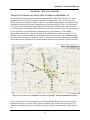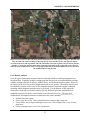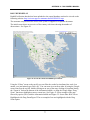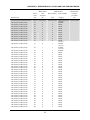
1
ROADKILL OBSERVATION COLLECTION SYSTEM (ROCS) Phase III Development Publication No. FHWA-CFL/TD-12-001 January 2012 Technical Report Documentation Page 1. Report No. 2. Government Accession No. 3. Recipient's Catalog No. FHWA-CFL/TD-12-001 4. Title and Subtitle 5. Report Date Roadkill Observation Collection System (ROCS): Phase III Development January 2012 6. Performing Organization Code 7. Author(s) 8. Performing Organization Report No. Robert Ament, Doug Galarus, Daniel Richter, Kelvin Bateman, Marcel Huijser and James Begley 9. Performing Organization Name and Address 10. Work Unit No. (TRAIS) Western Transportation Institute Montana State University P.O. Box 174250 Bozeman, MT 59717-4250 11. Contract or Grant No. DTFH68-07-E-00045 12. Sponsoring Agency Name and Address 13. Type of Report and Period Covered U.S. Department of Transportation Federal Highway Administration 1200 New Jersey Ave SE Washington, DC 20590 Final Report March 2008 – March 2011 14. Sponsoring Agency Code HEPM-30 15. Supplementary Notes COTR: Mary Gray, FHWA-HQ. Advisory Panel Members: Elisabeth Kolb, NYSDOT; Keith Knapp, ITRNS; and Roger Surdahl, FHWA-CFLHD. This project was funded under the FHWA’s Surface Transportation Environment and Planning Cooperative Research Program (STEP). 16. Abstract The Roadkill Observation Collection System (ROCS) is a multi-phased effort that has developed software for a tripartite system: rugged, handheld and integrated personal digital assistant (PDA) - global positioning system (GPS) data collectors, automatic uploads of data from the PDA-GPS units to a central electronic data repository and controlled admission to the ROCS central data server to access data to examine results on visualization software, for evaluation, summaries and reports. Data collection for this latest phase of the ROCS was conducted in 2010 and early 2011 in Iowa and New York by transportation maintenance crews removing animal carcasses along highways. An evaluation of a portion of the spatially accurate data (within 5-10 meters of actual location) using the central ROCS server indicate the data can be used to identify areas of high animal–vehicle collisions via a spatial cluster analysis, can be used to conduct a cost–benefit analyses for mitigation, and has the potential for other useful evaluations. Field and system tests of the ROCS have been completed indicating a fully functional system that is now ready for broader geographic deployment. 17. Key Words 18. Distribution Statement WILDLIFE–VEHICLE COLLISIONS, DATA COLLECTION, GPS ITS, PDA, ROCS 19. Security Classif. (of this report) Unclassified Form DOT F 1700.7 (8-72) No restriction. This document is available to the public from the sponsoring agency at the website http://www.cflhd.gov. 20. Security Classif. (of this page) Unclassified 21. No. of Pages 22. Price 122 Reproduction of completed page authorized SI* (MODERN METRIC) CONVERSION FACTORS APPROXIMATE CONVERSIONS TO SI UNITS Symbol When You Know Multiply By LENGTH In Ft Yd Mi inches feet yards miles 25.4 0.305 0.914 1.61 in2 ft2 yd2 Ac mi2 square inches square feet square yard acres square miles 645.2 0.093 0.836 0.405 2.59 fl oz Gal ft3 yd3 fluid ounces gallons cubic feet cubic yards Oz Lb T ounces pounds short tons (2000 lb) °F Fahrenheit Fc Fl foot-candles foot-Lamberts Lbf lbf/in2 poundforce poundforce per square inch To Find Symbol Millimeters Meters Meters Kilometers mm m m km Square millimeters Square meters Square meters Hectares Square kilometers mm2 m2 m2 ha km2 AREA VOLUME 29.57 Milliliters 3.785 Liters 0.028 cubic meters 0.765 cubic meters NOTE: volumes greater than 1000 L shall be shown in m3 mL L m3 m3 MASS 28.35 0.454 0.907 Grams Kilograms megagrams (or "metric ton") g kg Mg (or "t") TEMPERATURE (exact degrees) 5 (F-32)/9 or (F-32)/1.8 Celsius °C Lux candela/m2 lx cd/m2 ILLUMINATION 10.76 3.426 FORCE and PRESSURE or STRESS 4.45 6.89 Newtons Kilopascals N kPa APPROXIMATE CONVERSIONS FROM SI UNITS Symbol When You Know Multiply By LENGTH mm m m Km millimeters meters meters kilometers 0.039 3.28 1.09 0.621 mm2 m2 m2 Ha km2 square millimeters square meters square meters Hectares square kilometers 0.0016 10.764 1.195 2.47 0.386 mL L m3 m3 Milliliters liters cubic meters cubic meters 0.034 0.264 35.314 1.307 g kg Mg (or "t") grams kilograms megagrams (or "metric ton") 0.035 2.202 1.103 °C Celsius To Find Symbol Inches Feet Yards Miles in ft yd mi square inches square feet square yards Acres square miles in2 ft2 yd2 ac mi2 fluid ounces Gallons cubic feet cubic yards fl oz gal ft3 yd3 Ounces Pounds short tons (2000 lb) oz lb T AREA VOLUME MASS TEMPERATURE (exact degrees) 1.8C+32 Fahrenheit °F foot-candles foot-Lamberts fc fl ILLUMINATION lx cd/m2 lux candela/m2 0.0929 0.2919 N newtons 0.225 Poundforce lbf kPa kilopascals 0.145 poundforce per square inch lbf/in2 FORCE and PRESSURE or STRESS *SI is the symbol for the International System of Units. Appropriate rounding should be made to comply with Section 4 of ASTM E380. (Revised March 2003) ii ROADKILL OBSERVATION COLLECTION SYSTEM (ROCS) – TABLE OF CONTENTS TABLE OF CONTENTS EXECUTIVE SUMMARY ...........................................................................................................1 CHAPTER 1 – INTRODUCTION ...............................................................................................3 CHAPTER 2 – BACKGROUND..................................................................................................5 PHASE I: ROADKILL OBSERVATION COLLECTION SYSTEM (ROCS), PROOF OF CONCEPT .......................................................................................................................... 5 PHASE II: ROADKILL OBSERVATION COLLECTION SYSTEM (ROCS), PILOT PROJECT .................................................................................................................................. 6 CHAPTER 3 – OBJECTIVES FOR ROCS PHASE III ............................................................9 CHAPTER 4 – ROCS TECHNICAL DEVELOPMENT ........................................................11 DEVELOPMENT OF SOFTWARE TO FACILITATE UPLOADING THE DATA TO PCS AND A CENTRAL REPOSITORY ............................................................................. 11 FIELD TRAINING FOR USERS OF ROCS HANDHELD UNITS ................................. 15 DEVELOPMENT OF NEW SOFTWARE FOR DESKTOP COMPUTERS TO DISPLAY AND ANALYZE DATA ...................................................................................... 15 DEVELOPMENT OF A COMPUTER SERVER TO STORE AND DISTRIBUTE ELECTRONIC DATA ........................................................................................................... 16 DEVELOPMENT OF PROTOCOLS, FIREWALLS AND ACCESSIBILITY TO ELECTRONIC DATA IN A CENTRAL REPOSITORY .................................................. 20 OTHER CHANGES TO THE SYSTEM.............................................................................. 21 CHAPTER 5 – ROCS SYSTEM TEST .....................................................................................23 TESTS OF SYSTEM DATA COLLECTION, STORAGE AND RETRIEVAL.............. 23 POTENTIAL ANALYSIS AND REPORTING BASED ON DATA COLLECTED AT IOWA FIELD STUDY LOCATION .................................................................................... 25 Data Quality Control .......................................................................................................... 26 Species, Numbers, and Seasonal Distribution .................................................................. 26 Identification and Prioritization of Road Sections for Potential Mitigation Measures 27 Cost–Benefit Analyses ........................................................................................................ 33 Discussion and Recommendations on Spatial and Cost–Benefit Analyses .................... 39 CHAPTER 6 – CONCLUSIONS................................................................................................41 CHAPTER 7 – RECOMMENDATIONS ..................................................................................43 REFERENCES.............................................................................................................................45 APPENDIX A – ROCS USER’S MANUAL..............................................................................47 ROCS INTRODUCTION ...................................................................................................... 48 iii ROADKILL OBSERVATION COLLECTION SYSTEM (ROCS) – TABLE OF CONTENTS ROCS HARDWARE .............................................................................................................. 49 ROCS SOFTWARE USAGE ................................................................................................. 51 DATA OUTPUTS ................................................................................................................... 61 DATA TRANSFER ................................................................................................................. 63 REGISTRATION AND AUTOMATIC DATA TRANSFER............................................. 69 SYSTEM DETAILS ............................................................................................................... 72 TROUBLESHOOTING ......................................................................................................... 74 ROCS QUICK GUIDE ........................................................................................................... 76 Using ROCS ......................................................................................................................... 76 Soft Reset ............................................................................................................................. 76 Hard Reset ........................................................................................................................... 76 Contact Info ......................................................................................................................... 76 ROCS WEB DISPLAY........................................................................................................... 77 APPENDIX B – DEER MORTALITY VALUES AND DATA FOR IOWA ROADS ..........81 iv ROADKILL OBSERVATION COLLECTION SYSTEM (ROCS) – TABLE OF CONTENTS LIST OF FIGURES Figure 1. Increase in wildlife–vehicle collisions (bottom graph) compared to little or no growth in overall crashes (top graph) in the United States.(2) ............................................................. 3 Figure 2. Photo. The original Phase I, Proof of Concept, handheld data collector......................... 6 Figure 3. Photo. An integrated PDA-GPS handheld data collector developed and used in Phase II of the ROCS project. ............................................................................................................... 7 Figure 4. Screen Shot. A view of the ROCS PDA-GPS unit’s screen displaying the user registration form.................................................................................................................... 12 Figure 5. Screen Shot. A view of a ROCS PDA-GPS unit displaying confirmation of the completed registration process (Device ID is blacked out to maintain the user’s privacy). . 13 Figure 6. Screen Shot. An example of a ROCS PDA-GPS unit’s screen displaying connection status and checking to confirm the unit is registered in the central repository. .................... 14 Figure 7. Screen Shot. An example of ROCS PDA-GPS unit’s data transfer status report indicating all systems worked and the data transfer to the central repository was completed. ............................................................................................................................................... 14 Figure 8. Chart. ROCS central database organizational chart. ..................................................... 16 Figure 9. Screen Shot. Initial screen display at website for ROCS Roadkill Report. Green circles indicate where data has been collected and the numbers within the green circular markers represent the number of data observation records in that area.............................................. 17 Figure 10. Screen Shot. Example of an information bubble at ROCS Roadkill Report website.. 18 Figure 11. Screen Shot. ROCS Roadkill Report website viewing data under "terrain" mode. .... 19 Figure 12. Screen Shot. ROCS Roadkill Report website viewing data under "satellite" mode. .. 19 Figure 13. Screen Shot. Iowa roadkill data viewed via Google Maps® at ROCS Roadkill Report website. ................................................................................................................................. 23 Figure 14. Screen Shot. A view of data in “satellite imagery” mode at the ROCS Roadkill Report website. Green circles represent groups of observations. Red circles represent single observations. Numbers within green circles indicate number of roadkill records in that road segment. ................................................................................................................................ 24 Figure 15. Screen Shot. Example of exported data from the ROCS Roadkill Report database in a spreadsheet format. ............................................................................................................... 25 Figure 16. Screen Shot. A view of the observations that were entered from the Iowa DOT maintenance yard. ................................................................................................................. 26 Figure 17. Graph. The number of recorded white-tailed deer carcasses per month for the highways that were monitored in and around Iowa City, Iowa. ........................................... 27 Figure 18. Map. The deer mortality clusters and buffer zones along the five road sections in and around Iowa City, Iowa......................................................................................................... 29 Figure 19. Screen Shot. I-380, from junction with I-80 (south end or bottom of image) to junction with County Hwy E70 (north end or top of image) just north of bridge across the v ROADKILL OBSERVATION COLLECTION SYSTEM (ROCS) – TABLE OF CONTENTS Iowa River. Deer mortality clusters (red segments) appear associated with forest and a lake (southern cluster) and a creek and edge habitat (northern cluster). The buffer zone (blue segment) on the south end may be extended to the bridge rather than having it end after 1 km (0.62 miles) south of the southern cluster. Depending on the species that occur in the area, different types and dimensions of safe crossing opportunities may be needed in addition to barriers that keep the animals from accessing the road. ..................................... 31 Figure 20. Screen Shot. I-80, from junction with I-380 (west end or left side of image) to junction with County Hwy X30 (east end or right side of photo), just east of bridge across the Iowa River. Deer mortality cluster (red segment) appears associated with forest and edge habitat (yards in the forested patch). The end of the buffer zones (blue segments) may tie into the junction with County Road W66 (west side) and N. Dodge Street (east side). Depending on the species that occur in the area, different types and dimensions of safe crossing opportunities may be needed in addition to barriers that keep the animals from accessing the road. ................................................................................................................ 32 Figure 21. Screen Shot. US Hwy 218, from junction with I-80 (north end or top side of image) to junction with Hwy 22 (south end or lower in image) at Ryersons Woods. Deer mortality cluster (red segment) appears associated with forest and edge habitat. The end of the buffer zones (blue segments) may tie into the junction with Hwy 1 (north side) and Poweshiek St SE (south side). Depending on the species that occur in the area different types and dimensions of safe crossing opportunities may be needed in addition to barriers that keep the animals from accessing the road. .................................................................................... 33 Figure 22. Graph. The costs (in 2007 US$) per year (2010) associated with deer–vehicle collisions along the 19.1 km (11.9 mile ) long section of I-380 from the junction with I-80 to the junction with County Hwy E70. Figure includes the threshold values (at 3% discount rate) that need to be met in order to have the benefits of individual mitigation measures exceed the costs over a 75-year time period. Note that the costs at each 100 m (0.062 mile) long road section included each 100 m unit on either side (“the running average”) to estimate the costs per kilometer for each 100m unit............................................................. 35 Figure 23. Graph. The costs (in 2007 US$) per year (2010) associated with deer–vehicle collisions along the 26.0 km (16.2 mile) long section of US Hwy 218, from the junction with I-80 to the junction with Hwy 22. Figure includes the threshold values (at 3% discount rate) that need to be met in order to have the benefits of individual mitigation measures exceed the costs over a 75-year time period. Note that the costs at each 100 m (0.062 mile) long road section included each 100 m unit on either side (“the running average”) to estimate the costs per kilometer for each 100m unit............................................................. 36 Figure 24. Graph. The costs (in 2007 US$) per year (2010) associated with deer–vehicle collisions along the 20.8 km (12.9 mile) long section of Hwy 6, from the junction with I380 to the junction with US Hwy 151. Figure includes the threshold values (at 3% discount rate) that need to be met in order to have the benefits of individual mitigation measures exceed the costs over a 75-year time period. Note that the costs at each 100 m (0.062 mile) long road section included each 100 m unit on either side (“the running average”) to estimate the costs per kilometer for each 100m unit............................................................. 37 Figure 25. Graph. The costs (in 2007 US$) per year (2010) associated with deer–vehicle collisions along the 24.8 km (15.4 mile) long section of I-80, from the junction with I-380 vi ROADKILL OBSERVATION COLLECTION SYSTEM (ROCS) – TABLE OF CONTENTS to the junction with County Hwy X30. Figure includes the threshold values (at 3% discount rate) that need to be met in order to have the benefits of individual mitigation measures exceed the costs over a 75-year time period. Note that the costs at each 100 m (0.062 mile) long road section included each 100 m unit on either side (“the running average”) to estimate the costs per kilometer for each 100m unit............................................................. 38 Figure 26. Graph. The costs (in 2007 US$) per year (2010) associated with deer–vehicle collisions along the 13.4 km (8.3 mile) long section of I-80, from the junction with I380/Hwy 218 to the junction with Black Hawk Avenue. Figure includes the threshold values (at 3% discount rate) that need to be met in order to have the benefits of individual mitigation measures exceed the costs over a 75-year time period. Note that the costs at each 100 m (0.062 mile) long road section included each 100 m unit on either side (“the running average”) to estimate the costs per kilometer for each 100m unit. ....................................... 39 Figure 27. Photo. Trimble Recon. ................................................................................................. 49 Figure 28. Photo. Recon Power Boot Module. ............................................................................. 50 Figure 29. Photo. Recon keys. ...................................................................................................... 50 Figure 30. Screen Shot. PDA Start Menu showing the Roadkill Data Collection Application.... 51 Figure 31. Screen Shot. ROCS Information Screen. .................................................................... 52 Figure 32. Screen Shot. ROCS Main Application Screen when no session is in progress. .......... 53 Figure 33. Screen Shot. ROCS Monitoring Information Screen. ................................................. 54 Figure 34. Screen Shot. ROCS Monitoring Information Screen showing the expanded keypad. 55 Figure 35. Screen Shot. ROCS Notes Screen. .............................................................................. 56 Figure 36. Screen Shot. ROCS Main Application Screen during an active session. .................... 57 Figure 37. Screen Shot. ROCS Record Observation Screen. ....................................................... 58 Figure 38. Screen Shot. A session summary is shown after the session is stopped...................... 60 Figure 39. Screen Shot. Session Directory. .................................................................................. 61 Figure 40. Screen Shot. ActiveSync Partnership Options. ........................................................... 64 Figure 41. Screen Shot. Guest partnership screen. ....................................................................... 65 Figure 42. Screen Shot. Roadkill Files Directory. ........................................................................ 66 Figure 43. Screen Shot. Standard Partnership Options. ................................................................ 67 Figure 44. Screen Shot. Standard Partnership folder information. ............................................... 67 Figure 45. Screen Shot. Automatic synchronization of files via a standard partnership. ............. 68 Figure 46. Screen Shot. ROCS Registration Screen. .................................................................... 69 Figure 47. Screen Shot. ROCS Server Update - Transfer Complete. ........................................... 70 Figure 48. Screen Shot. Start Menu Items. ................................................................................... 70 Figure 49. Screen Shot. Disable Transfer Dialog Boxes. ............................................................. 71 Figure 50. Screen Shot. ROCS Roadkill Report Website............................................................. 77 vii ROADKILL OBSERVATION COLLECTION SYSTEM (ROCS) – TABLE OF CONTENTS Figure 51. Screen Shot. ROCS information bubble. .................................................................... 78 Figure 52. Screen Shot. ROCS Area Highlighted with Drag Zoom. ............................................ 78 Figure 53. Screen Shot. ROCS Zoomed in, Satellite View. ......................................................... 79 Figure 54. Screen Shot. ROCS Terrain View. .............................................................................. 79 Figure 55. Screen Shot. ROCS Display – Zoomed In. ................................................................. 80 viii ROADKILL OBSERVATION COLLECTION SYSTEM (ROCS) – TABLE OF CONTENTS LIST OF TABLES Table 1. Cutoff levels of deer road mortality values for the five road sections in and around Iowa City, Iowa.............................................................................................................................. 28 ix ROADKILL OBSERVATION COLLECTION SYSTEM (ROCS) – TABLE OF CONTENTS ACKNOWLEDGEMENTS The Montana State University, Western Transportation Institute authors Robert Ament, Doug Galarus, Daniel Richter, Kelvin Bateman, Marcel Huijser and James Begley would like to thank the people and partners who contributed financially in the pooled fund, provided intellectual information and review, and shared in the coordination of this effort including: The Connecticut Department of Transportation: Jeff Ward, Andrew Labonte, and Scott C. Williams The Iowa Department of Transportation: Troy Jerman and Steve Gent The Maryland State Highway Agency: William Branch The Minnesota Department of Transportation: Robert Weinholzer, Susan Sheehan, Jason Alcott, Peter Buchen, and Cassandra Isackson The New Hampshire Department of Transportation: Caleb Dobbins and Greg Placy The New York State Department of Transportation: Elisabeth Kolb, Kyle Williams, and Debra Nelson The Ohio Department of Transportation: Michelle May The Texas Department of Transportation: Dennis Markwardt and Stirling Robertson The Wisconsin Department of Transportation: James Merriman and Todd Matheson The U.S. Department of Transportation’s Federal Highway Administration, Office of Planning, Environment, and Realty: Mary Gray The U.S. Department of Transportation’s Federal Highway Administration, Central Federal Lands Highway Division: Roger Surdahl The U.S. Department of Transportation’s Research, Innovation and Technology Administration The authors would like to thank the many field personnel at the Iowa Department of Transportation who helped field test the equipment, collect data and use the ROCS system. The New York State Department of Transportation was instrumental in our field testing and data collection, in particular Kevin Matthaei and the maintenance crews at the Suffolk East Residency and Tom Story and the maintenance crews at the Ulster Residency. Special acknowledgement is granted to Keith Knapp who initiated this project while at the University of Wisconsin’s Deer Vehicle Crash Information and Research Center but concluded it with the Iowa State University’s Institute for Transportation. x EXECUTIVE SUMMARY EXECUTIVE SUMMARY There are an estimated one to two million vehicle collisions with large mammals in the United States and 45,000 in Canada each year. These wildlife–vehicle collisions (WVCs) have estimated direct annual costs to society of $6 billion to $12 billion in the United States and $281 million in Canada (in 2007 dollars). Three national (U.S.)/North American studies highlighted the need for systematic, accurate data collection for wildlife–vehicle collisions by transportation and natural resource agencies. This is needed to improve the identification and prioritization of sites for highway mitigation efforts. The facilitation of WVC data collection with a spatially accurate, efficient and easy to use system that decreases the need for manual collection and data entry also has the potential to increase standardized WVC data collection across North America. The Roadkill Observation Collection System (ROCS) is the product of a multi-phased effort that has developed software for a tripartite system: rugged, handheld and integrated personal digital assistant (PDA) data collectors with global positioning systems (GPS), automatic uploads of data from the PDA-GPS units to a central electronic data repository, and controlled admission to the ROCS central data server. The data at the central server can be accessed to examine results on visualization software, or for analyses, summaries and/or reports. Data collection for this latest phase of the ROCS was conducted in 2010 and early 2011 in Iowa and New York by transportation maintenance crews removing animal carcasses along highways. An evaluation of a portion of the spatially accurate data (within 5–10 meters of the actual location) collected by the PDA-GPS units and stored at the central ROCS server indicate the data can be used to identify areas with high numbers of WVCs via a spatial cluster analysis, can be used to conduct cost– benefit analyses for mitigation, and has the potential for other useful evaluations. Field and system tests of the ROCS have been completed and indicate a fully functional system that is now ready for broader geographic deployment. 1 EXECUTIVE SUMMARY (blank page) 2 CHAPTER 1 – INTRODUCTION CHAPTER 1 – INTRODUCTION The identification, location and mitigation of wildlife–vehicle collisions are of increasing interest to transportation and natural resource agencies across North America. There are an estimated one to two million collisions with large mammals in the United States and 45,000 in Canada each year. These wildlife–vehicle collisions have estimated direct annual costs to society of $6 billion to $12 billion in the United States and $281 million in Canada (in 2007 dollars). According to a national study, wildlife–vehicle collisions (WVCs) have increased an estimated 50 percent between 1990 and 2004 in the United States (Figure 1). Figure 1 also indicates WVCs comprise approximately 5 percent of all highway crashes in the United States based on the General Estimates System database.(1)(2) Figure 1. Increase in wildlife–vehicle collisions (bottom graph) compared to little or no growth in overall crashes (top graph) in the United States.(2) Collecting accurate WVC data is an acknowledged challenge for transportation and natural resource agencies: A survey of departments of transportation (DOTs) and departments of natural resources (DNRs) in a number of U.S. states and Canadian provinces indicated that most of the 3 CHAPTER 1 – INTRODUCTION responding DOTs (65%) and some DNRs (36%) collect WVC data. The final report, under the National Cooperative Highway Research Program (NCHRP), indicated that spatial accuracy of crash locations was often lacking.(3) In another NCHRP study, of the 25 top research and practice priorities related to wildlife and transportation in North America, priority no. 7 for transportation practice was “use standardized and vetted protocols for collecting and recording roadkill carcass and animal–vehicle collision data.”(4) A survey of the U.S. National Park Service reported that only one half of the respondents indicated they collect some sort of data on wildlife mortality caused by vehicles in those management units that have public roads.(5) Spatially accurate ungulate–vehicle collision (UVC) data—i.e., collisions involving deer, elk or moose—can be used to develop computer models with high predictive power in identifying factors that contribute to collisions. However, more noteworthy from this study was “the vast difference in predictive ability between the models developed with spatially accurate data on one hand and less accurate data obtained from referencing UVCs to a mile-marker system.”(6) The facilitation of WVC data collection with a spatially accurate, efficient and easy to use system that reduces the need for manual data collection and data entry has the potential to increase WVC data collection across North America by a variety of state, provincial and federal transportation and natural resource agencies. The benefits of such a system were best described by Huijser et al. (2007)(3): The occurrence of incidents that affect human safety, natural resource conservation, and monetary losses are documented; Changes in wildlife–vehicle collisions in time or space can be documented; Locations that may require mitigation can be identified and prioritized, allowing for an effective use of resources; and The effectiveness of mitigation measures in reducing collisions can be evaluated. This allows for modifications (if needed) and the application of lessons learned at other locations, again allowing for an effective use of resources. AUTHORS NOTE: Animal–vehicle collisions are crashes with wildlife and domestic animals e.g., horses, cattle and mules). Wildlife–vehicle collisions are those only with wildlife. Ungulate–vehicle collisions are those with wild hoofed animals such as moose, elk, deer, or bighorn sheep. 4 CHAPTER 2 – BACKGROUND CHAPTER 2 – BACKGROUND In order to avoid or reduce animal–vehicle collisions (AVCs) basic data on AVCs need to be recorded and analyzed. These data can illustrate the magnitude of the problem and potential changes over time. More importantly, they allow transportation and natural resource agencies to prioritize and focus their efforts to avoid or reduce collisions. However, not all state DOTs, DOT districts, or federal agencies record animal–vehicle collision data. Furthermore, those federal or state agencies that do record such data often use different methods. A national standard for the recording of animal–vehicle collisions would not only stimulate agencies and other organizations to collect these data, but would also allow for better integration and analyses of the data. The purpose of this project is to develop a system for the collection of animal–vehicle collision data and to demonstrate that PDAs in combination with a GPS were capable of collecting spatially precise and standardized data effectively and efficiently. PHASE I: ROADKILL OBSERVATION COLLECTION SYSTEM (ROCS), PROOF OF CONCEPT In 2005, the Western Transportation Institute at Montana State University (WTI) used $15,000 of its research funding from the U.S. Department of Transportation’s (USDOT’s) Research, Innovation and Technology Administration (RITA) to develop a proof-of-concept system (hardware and software). A commercially available Dell Axim® PDA (Microsoft-based) and Pharos® GPS were integrated with custom-developed software to form the proof of concept system (Figure 2). Key features included: An easy to use interface that facilitated rapid data entry. Standard, text-based, storage of individual observations and storage of the travel paths taken during a recording session that may have included several or many individual observations. Two modes: continuous monitoring (which included travel path and individual observations) and incidental observation. 5 CHAPTER 2 – BACKGROUND Figure 2. Photo. The original Phase I, Proof of Concept, handheld data collector. The proof of concept PDA-GPS unit was field tested by WTI and demonstrated to a number of prospective users. WTI also developed a self-tutorial CD to demonstrate the operation of the unit. An evaluation of the project indicated that it was an effective and precise data collector and easy to operate. One weakness that was identified in the first phase was that the PDA-GPS combination was vulnerable to damage during field use. Furthermore, desktop computer applications would need to be developed to make the data easy to download, display on maps, and prepare for analyses. Phase I was completed in early 2006. PHASE II: ROADKILL OBSERVATION COLLECTION SYSTEM (ROCS), PILOT PROJECT In Phase II, based on the evaluation of the proof of concept stage, the ROCS was further developed and refined. Partners for Phase II included the Virginia Transportation Research Council, Washington State DOT, WTI, the Federal Highway Administration and USDOTRITA. 6 CHAPTER 2 – BACKGROUND Feedback from the end-users before, during and after field use led to practical modifications and customization of the software and hardware in Phase II. Selected for data collection was a rugged, waterproof PDA field unit with an integrated GPS (Figure 3). The PDA is a Trimble Recon ® with the following attributes: Resistance to accidental immersion: 1 meter/30 minutes. Resistance to accidental drops: up to 4 feet. Sealed from dust and sand. Operation Temperatures: -22 to 140 degrees F. Battery life per charge: 12-15 hours. Two data storage locations: flash memory card and internal memory. Potential data collection: two weeks or more. The GPS is a Global Sat SIRF 3 ®, compact flash version. Its characteristics include: Requirement of locating three satellites (2-D fix). Accuracy (latitude/longitude): 5-10 meters. Accuracy (elevation): not as accurate. Figure 3. Photo. An integrated PDA-GPS handheld data collector developed and used in Phase II of the ROCS project. 7 CHAPTER 2 – BACKGROUND Phase II provided improvements to the hardware and software that made the device easier to use. The ROCS was developed so that field operators could learn to operate the handheld PDA-GPS unit in a short time and upload the data to a personal computer. This resulted in reduced workloads for road maintenance crews or other individuals collecting wildlife–vehicle collision carcass data. Feedback from users indicated the system achieved a satisfactory level of ease-ofuse and utility. Upon the completion of Phase II, the ROCS unit showed the following capabilities and improvements(7): Standardized, spatially precise data collection. User-friendly data entry in the field. The rugged field unit is sturdy and water and dust resistant. Demonstrated that data downloads reduced post-field data entry and simplified data management. Provided digital comma-separated values (CSV) or keyhole markup language (KML) output files that can be imported into mapping software and spreadsheet programs. Distinguished between “monitoring” and “incidental observations.” Capable of tracking the monitoring route for up to an entire day. Recorded the amount of time spent on the data collecting/search effort. 8 CHAPTER 3 – OBJECTIVES FOR ROCS PHASE III CHAPTER 3 – OBJECTIVES FOR ROCS PHASE III The key objective for Phase III was to systematize the ROCS field tested PDA-GPS units from Phase II for larger geographical information collection and collation (i.e., district-wide, statewide, regional or national applications). This would create the ability for cross-jurisdictional sharing of wildlife–vehicle collision data between and among transportation, law enforcement and natural resource agencies. Ultimately, it was envisioned that the system would readily integrate different data collection sources that were being stored on individual personal computers (PCs) across large geographic areas into one central location and make this information available to all contributors. It also would allow for data collection to be standardized. The objectives for Phase III of the ROCS included: Provide a means for users to view roadkill data on visualization software from their personal computers. Develop a means for users to access centrally stored data for summaries, reports and evaluations. Create protocols and firewalls so central data storage is secure and the information on the personnel collecting data can be easily retrieved. Demonstrate that data stored in the central repository can be used for spatial analysis and cost–benefit analysis. Train and support department of transportation maintenance personnel to use ROCS in their daily routines. Phase III was not directed to make recommendations for the system to move from research to deployment. Important issues such as an assessment of licensing the ROCS software, making it a freeware system, or reviewing other options for assuring high quality delivery and maintenance of the various system components over time were not developed for Phase III of the ROCS. 9 CHAPTER 3 – OBJECTIVES FOR ROCS PHASE III (blank page) 10 CHAPTER 4 – ROCS TECHNICAL DEVELOPMENT CHAPTER 4 – ROCS TECHNICAL DEVELOPMENT DEVELOPMENT OF SOFTWARE TO FACILITATE UPLOADING THE DATA TO PCS AND A CENTRAL REPOSITORY Software was designed, implemented and tested to allow the transfer of individual observation records to a central data repository. Some of the requirements identified for this process were: It should be easy to use, with minimal user input. It should be compatible with existing ROCS PDA-GPS software applications and data. It should have dual upload capability from the PDA-GPS units to 1) the central repository and 2) local personal computers. It should provide the user with feedback on the success or failure of the records transfer. It should be reasonably secure. To meet these requirements, a separate software routine was created and included as part of the ROCS PDA software installation process. The software is written in C# and was tested to run on both the Windows Mobile 5® and Windows Mobile 6® operating systems. The software program was written to initialize the transfer of the data from the PDA-GPS units to the central repository without user intervention. This eliminated the need for a user to remember to transfer data or to be familiar with a data transfer routine. At the same time it was designed to allow the user to turn this automated function off at his or her discretion in order to maintain control of the data sharing option. A registration process requires each ROCS handheld PDA-GPS unit to be registered with the central database prior to the repository’s acceptance of transferred data (Figure 4). This functionality adds a level of security, so only known sources of data can be placed into the central repository. It allows the ROCS to assure all observations in the central data base were derived from approved PDA-GPS units. 11 CHAPTER 4 – ROCS TECHNICAL DEVELOPMENT Figure 4. Screen Shot. A view of the ROCS PDA-GPS unit’s screen displaying the user registration form. This registration process only occurs once; after a PDA-GPS unit is accepted by the system, future uploads do not require registration. After the registration screen is filled in and submitted the user will be informed that the registration was completed (Figure 5). 12 CHAPTER 4 – ROCS TECHNICAL DEVELOPMENT Figure 5. Screen Shot. A view of a ROCS PDA-GPS unit displaying confirmation of the completed registration process (Device ID is blacked out to maintain the user’s privacy). When the ROCS Auto Upload program is enabled, it configures itself to automatically upload data when a PDA-GPS unit is connected to a local user’s PC. Upon connection to a PC it verifies that the PC has Internet connectivity and that it can establish a connection to the central database. It then verifies that the PDA-GPS unit is registered in the ROCS database and automatically uploads data (Figure 6). Upon the successful transfer of the data from the handheld unit to the central repository via the PC’s Internet connection, confirmation is displayed on the screen of the user’s handheld unit (Figure 7). 13 CHAPTER 4 – ROCS TECHNICAL DEVELOPMENT Figure 6. Screen Shot. An example of a ROCS PDA-GPS unit’s screen displaying connection status and checking to confirm the unit is registered in the central repository. Figure 7. Screen Shot. An example of ROCS PDA-GPS unit’s data transfer status report indicating all systems worked and the data transfer to the central repository was completed. 14 CHAPTER 4 – ROCS TECHNICAL DEVELOPMENT The data files that have been transferred are “marked” by the system so that they will not be transferred again. All the original files are still retained on the PDA for local use and transfer to a personal computer at the user’s location. Only the general observer information and the observation data are transferred to the central repository. The observer name and the monitoring route information retained on the PDA are only available for upload to the local user’s personal computer. FIELD TRAINING FOR USERS OF ROCS HANDHELD UNITS One of the sponsors of Phase III of this project was the Deer Vehicle Crash Information and Research Center (DVCIRC), which is a pooled fund study with participation by 10 state DOTs and the Federal Highway Administration. Two members of the DVCIRC, New York and Iowa, volunteered to receive and test the ROCS Phase III hardware, software and system protocols. Representatives from the two states each chose a suitable area in their jurisdictions where WVC rates were a concern. The Coralville area in eastern Iowa, which contains portions of Interstates 80 and 380, was selected as the Iowa test site. In New York, two areas were chosen: a rural setting in upstate New York, and eastern Long Island, which is geographically confined and borders a congested metropolitan area. Training sessions were held in Iowa and New York in January and February of 2010, respectively. The focus of the training was to familiarize maintenance crew personnel with the use of ROCS units. These personnel were to use the handheld data collectors as part of their animal carcass removal duties during 2010 and early 2011. During the training sessions a summary of the earlier phases was presented, along with the objectives of Phase III of the ROCS. Demonstrations on the use of the PDA-GPS units were conducted and each trainee used the PDA-GPS units to collect mock observations around the facilities where the training took place. Trainees then used the mock observations collected by the PDA-GPS units to learn the procedures for uploading the data to a personal computer in their offices. At the end of the training session, each state received two ROCS handheld PDA-GPS units to use for roadkill data collection. A ROCS Users Manual (Appendix A) was also created and a copy of the manual was provided with each PDA-GPS unit. Additional support was provided by ROCS project staff via the Internet and by telephone to support any questions or problems that arose during the collection of the data or uploading of information to personal computers in each state during 2010. DEVELOPMENT OF NEW SOFTWARE FOR DESKTOP COMPUTERS TO DISPLAY AND ANALYZE DATA To store the collection of ROCS observational data in a central location, a database was created on a server housed at the WTI offices. The database was a relational database implemented using a Microsoft SQL Server 2005®. The database has tables to keep track of the registration information from each of the PDA-GPS units in the system, data for each individual observation sent from registered PDAs, a list of the species that have been approved for collection and a log file recording the success and failure of data transfers. The relational design and associated need to keep the relational integrity of the database helps with validation of data sent to the database from the PDAs (Figure 8). 15 CHAPTER 4 – ROCS TECHNICAL DEVELOPMENT Figure 8. Chart. ROCS central database organizational chart. DEVELOPMENT OF A COMPUTER SERVER TO STORE AND DISTRIBUTE ELECTRONIC DATA The ROCS Phase 3 Statement of Work called for the development of new software for desktop computers to display and analyze data. The preference for using readily available maps and/or images is also articulated. To meet these needs, the ROCS used a web-based display built on the Google Maps® interface. Advantages to this system include: Eliminating the need to distribute, install, and maintain software on client PCs (this also bypasses any agency policy issues limiting the types of new software that can be installed on agency PCs). Leveraging a readily available, broadly used commercial product: Google Maps®. Easing the distribution of current and future versions of the ROCS interface to Google Maps® (only one copy of the program need be maintained, at the ROCS Roadkill Report website). Reduced future development and maintenance costs by simplifying system. Upon accessing the ROCS Roadkill Report website the user will be presented with a login screen and asked to log in using a pre-assigned login name and password. Then a map of the United States and Canada, with markers that show a count of the observations in the region, is displayed (Figure 9). Observations are represented by a single icon (green circular marker with number of observations), based on the geographical region covered by that icon on the map. 16 CHAPTER 4 – ROCS TECHNICAL DEVELOPMENT Figure 9. Screen Shot. Initial screen display at website for ROCS Roadkill Report. Green circles indicate where data has been collected and the numbers within the green circular markers represent the number of data observation records in that area. By default this initial display will show all observations for all species. The system allows the user to filter the observations by a variety of time periods or select solely for deer (nationally, the most common species in WVCs, see Huijser et al. 2008a). Filtering options are accessed by clicking on the Filters button in the upper left corner of the display.(2) The options for viewing the observation records displayed are: All observations. Last week’s observations. Last month’s observations. A particular year of observations (e.g., 2009, 2010, 2011). All species observations. Deer only observations. Clicking one of the green circular markers will show an information bubble that gives summary information about the species observations that make up the total (Figure 10). 17 CHAPTER 4 – ROCS TECHNICAL DEVELOPMENT Figure 10. Screen Shot. Example of an information bubble at ROCS Roadkill Report website. The user can view data at several spatial scales using the “drag zoom” feature (on the left side of the screen, see Figure 10) on the ROCS Roadkill Report website. This allows the user to increase or decrease spatial resolution, “zoom in/zoom out.” As a user selects a finer resolution (“zooms in”), the observation clusters become individual data observations (Figure 11 and Figure 12). At all spatial scales, clusters of observation records or individual observation records can be viewed in the original Google Maps® mode (Figure 10), which is the default mode of the ROCS Roadkill Report website. The website also allows the user to view the observation records in the terrain mode (Figure 11) or in the satellite imagery mode (Figure 12). 18 CHAPTER 4 – ROCS TECHNICAL DEVELOPMENT Figure 11. Screen Shot. ROCS Roadkill Report website viewing data under "terrain" mode. Figure 12. Screen Shot. ROCS Roadkill Report website viewing data under "satellite" mode. 19 CHAPTER 4 – ROCS TECHNICAL DEVELOPMENT The information present on the screen can be uploaded to the user’s PC as either a CSV file or a KML file for further analysis. The information exported for each observation record includes species, sex, date, time of day, latitude and longitude. Export options are accessed by clicking the Export button on the upper left corner of the website’s display screen (Figure 12). The display area may be used to cull the data to the area of interest, as only observation data currently on the display is included for export. This system has a few benefits to the users, including: Consolidation of the ROCS PDA-GPS unit data. o ROCS PDA-GPS unit software stores the observation data in separate files for each session; the files are combined for easy viewing at the ROCS Roadkill Report Website o The ROCS eliminates the need to manually combine the data. Ability to view North American, national or regional views of the collected data. The centralized system presents a view of all areas where data has been recorded, simplifying the process of combining data from adjoining locales (e.g., counties, states, etc.) or jurisdictions (e.g., National Parks or tribal areas) for analysis. DEVELOPMENT OF PROTOCOLS, FIREWALLS AND ACCESSIBILITY TO ELECTRONIC DATA IN A CENTRAL REPOSITORY Communication between the PDA-GPS units and the central database is accomplished through a Web Service application on the ROCS database server using an Extensible Markup Language (XML) format which is transferred using the Hyper Text Transport Protocol (HTTP). All data sent to the server includes a password and device identification (ID), which the server uses to verify that the device is authorized to upload data to the database. Each PDA-GPS unit has a unique device ID, which is registered to an organization in the database. Authorization to put data in the central database is associated with the device, not the organization. If an organization is passing the device to another organization, it should un-register the device so that it can be registered with the next organization. Communication is always initiated by the PDA-GPS unit; the first message sent is a request for the device’s registration status. If the device is unregistered, the user is prompted to enter registration info (see Figure 6). When the new registration information is sent, the transfer application closes the connection and shuts down (the registration must be approved before the device can upload data). If the registration is active then the program will cycle through each observation session, package all the observations in that session into an XML file, send it to the server and, if the transfer is successful, mark the session as sent. Data transfer is done on a per session basis; if one observation in that session has an error, the whole session is passed by. All errors are logged in an error table of the database with an explanation of why the error occurred. A session that failed to be transferred will not be marked as sent; the PDA will try to re-send the session every time a transfer is started until it is successful. 20 CHAPTER 4 – ROCS TECHNICAL DEVELOPMENT OTHER CHANGES TO THE SYSTEM In addition to the items listed above that were tasks specified to be completed as part of this phase of the ROCS project, a few changes were made to the ROCS PDA-GPS unit software in response to user comments from the previous phase. These changes include the following: Renaming of the of the screen controls to be more user friendly and understandable, such as “Start GPS” and “Stop GPS” becoming “New Session” and “End Session.” Sessions are periods of active recording of observations and are delimited by when the user clicks the “New Session” and “End Session” buttons. Modifying the application so the virtual keyboard pops up if the focus is placed on a text field. Saving the date and time (in Coordinated Universal Time, or UTC) from the GPS data to the observation data records. This ensures the accuracy of the temporal data in the event that the PDA time/date gets reset due to a battery or system software issue. A “Test Session” option was added to allow test observations to be made during training/testing. These observations will be identified as tests so they will not be combined with real data. ROCS PDA-GPS User Manual (Appendix A) documentation was updated to reflect new functionality as well as changes to previous functionality. 21 CHAPTER 4 – ROCS TECHNICAL DEVELOPMENT (blank page) 22 CHAPTER 5 – ROCS SYSTEM TEST CHAPTER 5 – ROCS SYSTEM TEST TESTS OF SYSTEM DATA COLLECTION, STORAGE AND RETRIEVAL In November 2010 the software to automatically send ROCS PDA-GPS unit data to a central repository housed at WTI was complete and ready for deployment. The new version of the ROCS software, including the transfer routines, was packaged with updated documentation and installation instructions and sent to representatives from Iowa and New York. Iowa personnel were able to successfully upgrade their ROCS PDA-GPS units with the new software version. As a result, upon connecting the PDA-GPS units to an Internet-connected PC, the data collected by Iowa personnel was automatically transferred to the central database. The roadkill observations could then be viewed at the ROCS Roadkill Report website (see Figure 13). In addition, once the central database was populated with observation data, the information could be exported for evaluation or reporting. As of 31 December 2010, there have been 191 roadkill observation records uploaded to the central database from the two Iowa ROCS PDA-GPS units. Figure 13. Screen Shot. Iowa roadkill data viewed via Google Maps® at ROCS Roadkill Report website. Tests were performed to look at the data at the ROCS Roadkill Report website in each region. Regional clusters were viewed at finer spatial resolution, such as data from Iowa (Figure 14). Also, observational data was viewed under each mode, such as satellite imagery mode (Figure 15). 23 CHAPTER 5 – ROCS SYSTEM TEST Finally, a test was performed on the Export function, with which the viewed data is exported to a CSV file for use/analysis outside of the ROCS Roadkill Report website (see Figure 15). The successful test confirmed that the observational data at the central repository can be made available for analysis by other software programs that a user may possess. Figure 14. Screen Shot. A view of data in “satellite imagery” mode at the ROCS Roadkill Report website. Green circles represent groups of observations. Red circles represent single observations. Numbers within green circles indicate number of roadkill records in that road segment. 24 CHAPTER 5 – ROCS SYSTEM TEST Figure 15. Screen Shot. Example of exported data from the ROCS Roadkill Report database in a spreadsheet format. Due to a season of particularly bad weather, New York maintenance crews did not have a chance to upgrade their PDA-GPS units with ROCS Phase III software before the completion of the project. Arrangements are being made to upgrade the devices and send them back to New York so they may take advantage of the system’s new functionality with their two PDA-GPS units. The system test has shown that all designed functions for ROCS Phase III are operational, from PDA-GPS unit data collection and transfer software functions, central database storage and retrieval of observation information, to exporting selected data residing in the system for purposes of analysis or reporting. POTENTIAL ANALYSIS AND REPORTING BASED ON DATA COLLECTED AT IOWA FIELD STUDY LOCATION The project conducted an analysis of a portion of the data to demonstrate the utility of the system. Data collected over a 10-month period in Iowa provided the basis for a spatial cluster analysis and a cost–benefit analysis. It should be noted these analyses were conducted on a very select and limited amount of data and thus are illustrative, not conclusive. There are other GIS software programs available to review the data and other software programs available to evaluate the data; therefore, the project’s selection of just two analyses for this project should be viewed simply as a sample of how the ROCS can be utilized. 25 CHAPTER 5 – ROCS SYSTEM TEST Data Quality Control Before the ROCS units were used to record road-killed animals along the roads in and around Iowa City, the units and the data entry software were tested by instructors as well as Iowa DOT personnel. However, not all of these data were marked as test data. To minimize the inclusion of test data in this analysis, the researchers deleted all data entered through 1 March 2010 and only included data entered from 2 March 2010 through 31 December 2010. Investigation of the remaining data still showed the presence of some data that were unlikely to be records of the presence of actual carcasses. Several records were located in the Iowa DOT maintenance yard (Figure 16), and some of these were of species unlikely to be found in the area. The four data entries that originated from the maintenance yard were all removed. The carcasses listed in these records were white-tailed deer (Odocoileus virginianus), cattle (Bos taurus), bison (Bos bison), and bighorn sheep (Ovis canadensis). In addition, there was one data entry along a road that was classified as bison. For the purpose of this analysis this observation was assumed to be related to white-tailed deer instead. Figure 16. Screen Shot. A view of the observations that were entered from the Iowa DOT maintenance yard. The display of the locations of the observations allows for an easy check on potential test entries because most such records were entered from a few known locations. Note that some of the observations shown in this figure were entered before 2 March 2010 and were thus already excluded from the dataset. Species, Numbers, and Seasonal Distribution Between 2 March 2010 and 31 December 2010 there were 207 valid data entries. Almost all of these (206; 99.5%) were records of white-tailed deer carcasses, and one (0.5%) was a coyote (Canis latrans). The seasonal distribution of the observations for white-tailed deer is consistent with that found in other deer–vehicle collision studies throughout North America; a small peak around late spring/early summer (May/June), and a substantially larger peak in the autumn (October/November). The coyote carcass was observed on 29 April 2010. The peak for deer– vehicle collisions around late spring/early summer may be related to increased feeding activity after winter and independence of the young of the previous year, whereas the peak in the fall is 26 CHAPTER 5 – ROCS SYSTEM TEST related to increased activity during the rut (Figure 17). If data are collected over a greater area or over a longer period of time (e.g., multiple years), the sample size will increase and the seasonal distribution will become smoother and more robust.(2) White‐tailed deer carcasses (N) 90 80 70 60 50 40 30 20 10 0 Mar Apr May Jun Jul Aug Sep Oct Nov Dec Month (2010) Figure 17. Graph. The number of recorded white-tailed deer carcasses per month for the highways that were monitored in and around Iowa City, Iowa. Identification and Prioritization of Road Sections for Potential Mitigation Measures One of the primary purposes of collecting this data through the ROCS PDA-GPS units is to identify and prioritize road sections that may require mitigation measures. As an example, five road sections were selected from the dataset for further analyses: 11.9 mile (19.1 km) of I-380, from junction with I-80 (south end) to junction with County Hwy E70 (north end). 16.2 mile (26.0 km) of US Hwy 218, from junction with I-80 (north end) to junction with Hwy 22 (south end). 12.9 mile (20.8 km) of Hwy 6, from junction with I-380 (east end) to junction with US Hwy 151 (west end). 15.4 mile (24.8 km) of I-80, from junction with I-380 (west end) to junction with Co Hwy X30 (Baker Ave) (east end). 8.3 mile (13.4 km) of I-80, from junction with I-380/Hwy 218 (east end) to junction with Black Hawk Avenue (west end). For the purpose of this analysis, the researchers only included observations of white-tailed deer; the one observation of a coyote was ignored. Each of the five road sections was divided into 100-meter-long road units (328 feet) and each roadkill observation was assigned to the nearest unit. 27 CHAPTER 5 – ROCS SYSTEM TEST For each 100-m-long road unit, a “deer road mortality value” was calculated by taking the sum of roadkills found in the unit concerned and combining it with its two neighboring 100-m units. Thus the “deer road mortality value” for each 100-m road unit was related to the number of mortality observations in a 0.3-km road length section. For example, if adjacent 100-m-long units had 3, 2, 4, and 2 deer carcass observations, respectively, the “deer road mortality value” for the second and third 100-m unit of this highway segment would be 9 (3+2+4) and 8 (2+4+2), respectively (see also Appendix B). This method is intended to account for two potential errors in the data collection: 1) an observation may have actually occurred in the neighboring 100-m road unit as a consequence of the PDA-GPS unit only being accurate within 5-10 m, or, 2) the location of the carcass may have been slightly different from the location of the observer entering the data on the PDA-GPS unit, leading to spatial imprecision. This deer road mortality value also provides a smoother transition between adjacent 100-m road units because each unit’s value was influenced by its two neighboring 100-m units. Potential mitigation measures for white-tailed deer have to be implemented at a spatial scale that is consistent with the species home range size (see Huijser et al. 2008b for a review). This evaluation concerning white-tailed deer assumed a home range of 70 hectares (home range diameter of 944 m). Therefore, working on a scale of 100 m or 300 m is still relatively precise in relation to the distances white-tailed deer are known to cover with ease and regularity.(8) Six categories of the deer road mortality values were distinguished for the 100-m road units. The categories were determined using the following procedure: 100-m units with a “0” deer road mortality value were classified as “absent” (Table 1). Researchers calculated the 20, 40, 60 and 80 percentiles of the remaining 100-m units, each of which showed a value of 1 or higher, and classified each of the units according to the following categories: “very low” (>0-20%), “low” (20-40%), “medium” (40-60%), “high” (60-80%), and “very high” (80-100%) (Table 1). Table 1. Cutoff levels of deer road mortality values for the five road sections in and around Iowa City, Iowa. Road Sections All five road sections combined Absent 0 Very low 1 Low Medium High Very high 1 1 2 3-5 The number of white-tailed deer carcasses per 100-m road unit varied between 0 and 3, and the deer road mortality values per 100-m road unit varied between 0 and 5 (see Appendix B). These numbers are low as a consequence of the relatively short monitoring period (2 March 2010 through 31 December 2010), which in turn resulted in a limited range for the deer road mortality values (0-5). With such a limited range of deer road mortality values, different percentile categories may relate to the same value. For example, a deer mortality value of 1 resulted in the 100-m road unit being classified across the “very low” and “medium” cutoff levels (Table 1). The addition or removal of just one deer carcass record would change the classification to “absent” or “high.” Therefore the current process for the identification and prioritization of road sections that may require mitigation is mostly aimed at demonstrating what the data can be used 28 CHAPTER 5 – ROCS SYSTEM TEST for rather than providing real advice for implementing mitigation measures for selected locations by this analysis. The researchers identified “deer road mortality clusters” by marking all 100-m road units categorized as “very high” (Appendix B). If a 100-m road unit marked as “very high” had adjacent units that were classified as “high,” these units were marked as well (Appendix B). The “marking” on either side of a 100-m road unit classified as “very high” stopped when a 100-m road unit occurred that was classified as “medium” or lower. If a 100-m road unit classified as “high” was not adjacent to a 100-m road unit classified as “very high,” it was not included in the deer road mortality clusters. Thus, “deer mortality clusters” consisted of the “worst 20%” of all 100-m road units (excluding the 100-m road units that were classified as “absent”) and the adjacent 100-m units, as long as those units fell within the “worst 40%” (excluding the 100 m road units that were classified as “absent”) (Appendix B). Note that the deer road mortality clusters were based on only 10 months of data. Therefore the location of the deer road mortality clusters in this analysis is not very robust. The deer road mortality clusters are marked in red in Figure 18. Figure 18. Map. The deer mortality clusters and buffer zones along the five road sections in and around Iowa City, Iowa. If deer road mortality in the deer road mortality clusters is reduced through the installation of wildlife fencing in combination with safe crossing opportunities, deer may still gain access at the fence ends to the road and the vegetation in the right-of-way. Such behavior might lead to a change in location of wildlife–vehicle collisions rather than a substantial reduction. Therefore 29 CHAPTER 5 – ROCS SYSTEM TEST mitigation measures aimed at reducing wildlife–vehicle collisions and providing safe crossing opportunities for wildlife should have buffer zones that extend beyond the location of the actual deer mortality clusters. Based on the diameter of the home range for white-tailed deer, the analysis applied a buffer zone of 1 km (0.62 mile) on both sides of each deer road mortality cluster. This analysis only included deer road mortality data; it did not include observations of where animals may cross the road successfully, nor data on other species. It is important to consider such additional data in order to avoid erecting barriers, such as fencing, at locations where the target species or other species may be successfully crossing the highway. In addition to buffer zones of 1 km on each side of a deer mortality cluster, the analysis applied a minimum size for a gap between locations of mitigation measures designed to keep wildlife from accessing the road. The minimum distance between where a fence, or other barrier type, ends and another barrier starts, was set at 0.62 mile (1 km). The buffer zones on either side of the deer road mortality clusters are marked in blue in Figure 18. The 1 km length of the buffer zone on each side of a deer mortality cluster is a guideline for the length of fences or other potential barriers, but final decisions on the actual location and length should be based on the local situation and additional data regarding successful crossing opportunities for deer and other species. This analysis prioritized the deer road mortality clusters by tallying the number of observed deer carcasses in a cluster and standardizing this value by dividing this number by the number of 100m road units that the cluster consisted of (see Appendix B). The higher the number of observed deer carcasses per 100 m unit, the higher the priority for implementing mitigation measures. The deer road mortality clusters had a prioritization value between 0.67 (relatively low priority) and 1.17 (relatively high priority) (see Appendix B). To visualize the location of three deer mortality clusters on three different highway segments, the clusters and their buffer zones were plotted using satellite imagery as a background (Figures 1921). 30 CHAPTER 5 – ROCS SYSTEM TEST Figure 19. Screen Shot. I-380, from junction with I-80 (south end or bottom of image) to junction with County Hwy E70 (north end or top of image) just north of bridge across the Iowa River. Deer mortality clusters (red segments) appear associated with forest and a lake (southern cluster) and a creek and edge habitat (northern cluster). The buffer zone (blue segment) on the south end may be extended to the bridge rather than having it end after 1 km (0.62 miles) south of the southern cluster. Depending on the species that occur in the area, different types and dimensions of safe crossing opportunities may be needed in addition to barriers that keep the animals from accessing the road. 31 CHAPTER 5 – ROCS SYSTEM TEST Figure 20. Screen Shot. I-80, from junction with I-380 (west end or left side of image) to junction with County Hwy X30 (east end or right side of photo), just east of bridge across the Iowa River. Deer mortality cluster (red segment) appears associated with forest and edge habitat (yards in the forested patch). The end of the buffer zones (blue segments) may tie into the junction with County Road W66 (west side) and N. Dodge Street (east side). Depending on the species that occur in the area, different types and dimensions of safe crossing opportunities may be needed in addition to barriers that keep the animals from accessing the road. 32 CHAPTER 5 – ROCS SYSTEM TEST Figure 21. Screen Shot. US Hwy 218, from junction with I-80 (north end or top side of image) to junction with Hwy 22 (south end or lower in image) at Ryersons Woods. Deer mortality cluster (red segment) appears associated with forest and edge habitat. The end of the buffer zones (blue segments) may tie into the junction with Hwy 1 (north side) and Poweshiek St SE (south side). Depending on the species that occur in the area different types and dimensions of safe crossing opportunities may be needed in addition to barriers that keep the animals from accessing the road. Cost–Benefit Analyses Over 40 types of mitigation measures aimed at reducing collisions with large ungulates have been described. Examples include warning signs that alert drivers to potential animal crossings, wildlife warning reflectors or mirrors, wildlife fences, and animal detection systems. However, the effectiveness and costs of these mitigation measures vary greatly. When their effectiveness is evaluated in relation to the costs for the mitigation measure, important insight is obtained regarding which mitigation measures may be preferred. For the purpose of this report the researchers conducted cost–benefit analyses for four different types and combinations of mitigation measures for the five road sections in and around Iowa City. The types and combinations of mitigation measures evaluated for this report included(9)(10)(2)(11)(12)(13)(14): Animal detection system. Fence, gap (once every 2 km), animal detection system in gap, jump-outs. Fence, under- and overpass (underpass once every 2 km, overpass once every 24 km), jump-outs. Fence, underpass (once every 2 km), jump-outs. 33 CHAPTER 5 – ROCS SYSTEM TEST For details on the effectiveness and estimated costs of the mitigation measures per kilometer (0.62 mile) per year and other methodological aspects of the cost–benefit analyses see Huijser et al. (2009). This publication also provides a rationale for the estimated average costs associated with each deer–vehicle collision ($6,617). The cost for deer–vehicle collisions is expressed in dollars per year per kilometer (0.62 mi). However, the data collected for the roads in and around Iowa City only relate to March through December and do not include January and February. Based on national data, the researchers estimated the percentage of deer–vehicle collisions that occurred in January and February 2010 to be 10 percent of the total number of collisions in a year (March 2010 through December 2010 = 90 percent). Therefore a correction factor of 1.11 was applied to the data from March through December to obtain an estimate for the number of deer–vehicle collisions for a full year.(1)(2) Figures 22 through 26 illustrate the road sections for which the number of recorded deer carcasses was high enough to meet or exceed thresholds for the implementation of four different types of mitigation measures. Each of the four road sections had road segments where the threshold values for all four mitigation measures were (nearly) met or exceeded. While the researchers strongly advise to use the cost–benefit analyses as a decision support tool, they also urge users to recognize that it is only one of the factors that may or should be considered in the decision making process (see Discussion and Conclusions). 34 Deer-vehicle collision costs (US$/km/yr) CHAPTER 5 – ROCS SYSTEM TEST I-380 from Jct I-80 to Jct Co Hwy E70 $70,000 $60,000 $50,000 $40,000 $30,000 $20,000 $10,000 $0 50 100 150 100 m road unit (from Jct I-80 to Jct Co Hwy E70) Threshold animal detection system Threshold fence, gap, animal detection system, jump-outs Threshold fence, under- and overpass, jump-outs Threshold fence, under pass, jump-outs Figure 22. Graph. The costs (in 2007 US$) per year (2010) associated with deer–vehicle collisions along the 19.1 km (11.9 mile ) long section of I-380 from the junction with I-80 to the junction with County Hwy E70. Figure includes the threshold values (at 3% discount rate) that need to be met in order to have the benefits of individual mitigation measures exceed the costs over a 75-year time period. Note that the costs at each 100 m (0.062 mile) long road section included each 100 m unit on either side (“the running average”) to estimate the costs per kilometer for each 100m unit. 35 Deer-vehicle collision costs (US$/km/yr) CHAPTER 5 – ROCS SYSTEM TEST Hwy 218 from Jct I-80 to Jct Hwy 22 $70,000 $60,000 $50,000 $40,000 $30,000 $20,000 $10,000 $0 50 100 150 200 250 100 m road unit (from Jct I-80 to Jct Hwy 22) Threshold animal detection system Threshold fence, gap, animal detection system, jump-outs Threshold fence, under- and overpass, jump-outs Threshold fence, under pass, jump-outs Figure 23. Graph. The costs (in 2007 US$) per year (2010) associated with deer–vehicle collisions along the 26.0 km (16.2 mile) long section of US Hwy 218, from the junction with I-80 to the junction with Hwy 22. Figure includes the threshold values (at 3% discount rate) that need to be met in order to have the benefits of individual mitigation measures exceed the costs over a 75-year time period. Note that the costs at each 100 m (0.062 mile) long road section included each 100 m unit on either side (“the running average”) to estimate the costs per kilometer for each 100m unit. 36 Deer-vehicle collision costs (US$/km/yr) CHAPTER 5 – ROCS SYSTEM TEST Hwy 6 from Jct I-380 to Jct Hwy 151 $60,000 $50,000 $40,000 $30,000 $20,000 $10,000 $0 50 100 150 200 100 m road unit (from Jct I-380 to Jct Hwy 151) Threshold animal detection system Threshold fence, gap, animal detection system, jump-outs Threshold fence, under- and overpass, jump-outs Threshold fence, under pass, jump-outs Figure 24. Graph. The costs (in 2007 US$) per year (2010) associated with deer–vehicle collisions along the 20.8 km (12.9 mile) long section of Hwy 6, from the junction with I-380 to the junction with US Hwy 151. Figure includes the threshold values (at 3% discount rate) that need to be met in order to have the benefits of individual mitigation measures exceed the costs over a 75-year time period. Note that the costs at each 100 m (0.062 mile) long road section included each 100 m unit on either side (“the running average”) to estimate the costs per kilometer for each 100m unit. 37 Deer-vehicle collision costs (US$/km/yr) CHAPTER 5 – ROCS SYSTEM TEST I-80 from Jct I-380 to Jct Co Hwy X30 $50,000 $45,000 $40,000 $35,000 $30,000 $25,000 $20,000 $15,000 $10,000 $5,000 $0 50 100 150 200 100 m road unit (from Jct I-380 to Jct Co Hwy X30) Threshold animal detection system Threshold fence, gap, animal detection system, jump-outs Threshold fence, under- and overpass, jump-outs Threshold fence, under pass, jump-outs Figure 25. Graph. The costs (in 2007 US$) per year (2010) associated with deer–vehicle collisions along the 24.8 km (15.4 mile) long section of I-80, from the junction with I-380 to the junction with County Hwy X30. Figure includes the threshold values (at 3% discount rate) that need to be met in order to have the benefits of individual mitigation measures exceed the costs over a 75-year time period. Note that the costs at each 100 m (0.062 mile) long road section included each 100 m unit on either side (“the running average”) to estimate the costs per kilometer for each 100m unit. 38 Deer-vehicle collision costs (US$/km/yr) CHAPTER 5 – ROCS SYSTEM TEST I-80 from Jct Hwy 218 to Jct Black Hawk Ave $40,000 $35,000 $30,000 $25,000 $20,000 $15,000 $10,000 $5,000 $0 50 100 100 m road unit (from Jct Hwy 218 to Jct Black Hawk Ave) Threshold animal detection system Threshold fence, gap, animal detection system, jump-outs Threshold fence, under- and overpass, jump-outs Threshold fence, under pass, jump-outs Figure 26. Graph. The costs (in 2007 US$) per year (2010) associated with deer–vehicle collisions along the 13.4 km (8.3 mile) long section of I-80, from the junction with I-380/Hwy 218 to the junction with Black Hawk Avenue. Figure includes the threshold values (at 3% discount rate) that need to be met in order to have the benefits of individual mitigation measures exceed the costs over a 75-year time period. Note that the costs at each 100 m (0.062 mile) long road section included each 100 m unit on either side (“the running average”) to estimate the costs per kilometer for each 100m unit. Discussion and Recommendations on Spatial and Cost–Benefit Analyses Because of the relatively limited time period over which the data collected could be used for analysis (2 March 2010 through 31 December 2010) the numbers of observed deer carcasses for each 0.062 (100 m) long road unit was relatively low. This in turn resulted in a limited range for the deer road mortality values (0-5). With such a limited range the differences between the percentile categories are very small. This makes the identification and prioritization of the road sections that may require mitigation unreliable. However, the analyses presented in this report are mostly aimed at 39 CHAPTER 5 – ROCS SYSTEM TEST demonstrating what the data can be used for rather than providing real advice for implementing mitigation measures in the selected locations. The researchers suggest continuing with the data collection for at least five years before the data are used to identify and prioritize road sections where mitigation measures will be implemented. Within the five road sections that were analyzed the researchers identified 19 road units with “very high” road mortality. However, these deer mortality clusters were designated based on having a relatively high number of recorded deer carcasses rather than meeting or exceeding a certain threshold (see next point for meeting or exceeding thresholds). For each of the 19 deer mortality clusters a prioritization value was calculated. Locations where animals are found dead on and alongside the road are not necessarily the same locations where animals are crossing the road successfully. Decisions on the types of mitigation measures, especially barriers, should not be based only on where carcasses are found, but data on successful crossings of the target species as well as other species should also be considered. Also, it is considered good practice to not increase the barrier effect of a road (e.g., through wildlife fencing) without also providing for safe crossing opportunities. The cost–benefit analyses the road sections where the number of recorded deer carcasses was high enough to meet or exceed thresholds for the implementation of four different types of mitigation measures. Each of the four road sections had road segments where the threshold values for all four mitigation measures were (nearly) met or exceeded. The cost–benefit analysis is relatively conservative and does not include passive use values. For a full understanding what is and what is not included in the cost–benefit analyses and how the analyses were conducted please see Huijser et al. (2009). It is also important to know that the costs and benefits are expressed in 2007 US$. Since the costs associated with deer–vehicle collisions and with mitigation measures change continuously and can even vary substantially depending on the geographic region, the cost–benefit analyses should be regarded as indicative. The researchers would also like to point out that the cost–benefit analyses do not include all parameters that should be considered when making a decision on the implementation of potential mitigation measures. The researchers strongly advise to use the cost–benefit analyses as a decision support tool but also urge users to recognize that it is only one of the factors that may or should be considered in the decision making process.(1) 40 CHAPTER 6 – CONCLUSIONS CHAPTER 6 – CONCLUSIONS The Roadkill Observation Collection System (ROCS) is a multi-phased effort that has led to the development of software for a tripartite system: rugged, handheld and integrated personal digital assistant data collectors with global positioning systems, automatic uploads of data from the PDA-GPS units to a central electronic data repository, and controlled admission to the ROCS central data server to examine results on visualization software, as well as for analyses, summaries and reports. An evaluation of a portion of the spatially accurate data collected in Iowa using the central ROCS server indicate the data can be used to identify areas with a high number of animal–vehicle collisions via a spatial cluster analysis, can be used to conduct a cost– benefit analyses for mitigation, and has the potential for other useful evaluations. Field and system tests of the ROCS have been completed indicating a fully functional system that is now ready for broader geographic deployment. 41 CHAPTER 6 – CONCLUSIONS (blank page) 42 CHAPTER 7 –RECOMMENDATIONS CHAPTER 7 – RECOMMENDATIONS These are additional recommended improvements to the ROCS for future deployment. While the Phase III PDA-GPS units are viable, consideration should be given to alternate, less-expensive options. Cellular smart phones have become more common, and most include an integrated GPS that is accurate and precise. If agency staff who are responsible for crash or carcass data collection have smart phones, developing a software application for ROCS for these devices would be beneficial and reduce the costs of broad geographical deployment since it would reduce the necessity of obtaining the rugged PDA-GPS units used in Phase III. There could be further improvements to the visualization functions of the ROCS Roadkill Report website. Additional geographical filtering and zoom options could be developed, as well as additional time period filtering options. Icons could be improved in ways that make ROCS more user friendly, including icons that better represent the species commonly found as roadkill. The ROCS Roadkill Report website could include analysis algorithms. They were not developed for Phase III, since it was assumed individual users would best be able to select and apply their own analysis on data downloaded from the ROCS. However, if at a future date a national standard for roadkill data analysis were developed, it could be incorporated into the ROCS Roadkill Report website. 43 CHAPTER 7 –RECOMMENDATIONS (blank page) 44 REFERENCES REFERENCES (1) Huijser, M. P., J. W. Duffield, A. P. Clevenger, R. J. Ament and P. T. McGowen. 2009. Cost–benefit analyses of mitigation measures aimed at reducing collisions with large ungulates in the United States and Canada; a decision support tool. Ecology and Society 14(2):15. URL: http://www.ecologyandsociety.org/viewissue.php?sf=41 (2) Huijser, M. P., P. McGowen, J. Fuller, A. Hardy, A. Kociolek, A. P. Clevenger, D. Smith and R. Ament. 2008a. Wildlife–vehicle collision reduction study. Report to Congress. U.S. Department of Transportation, Federal Highway Administration, Washington D.C., USA. URL: http://www.tfhrc.gov/safety/pubs/08034/index.htm (3) Huijser, M. P., J. Fuller, M. E. Wagner, A. Hardy and A. P. Clevenger. 2007. Animal– vehicle collision data collection. A synthesis of highway practice. NCHRP Synthesis 370. Project 20-05/Topic 37-12. Transportation Research Board of the National Academies, Washington DC, USA. URL: http://www.trb.org/news/blurb_detail.asp?id=8422 (4) Bissonette, J. 2007. Evaluation of the Use and Effectiveness of Wildlife Crossings, NCHRP 25-27. Prepared for the National Cooperative Highway Research Program, Transportation Research Board, National Research Council. USGS Utah Cooperative Fish and Wildlife Research Unit, Department of Wildland Resources, College of Natural Resources, Logan, Utah. URL: http://onlinepubs.trb.org/onlinepubs/archive/NotesDocs/25-27_FR.pdf (5) Ament, R., A. P. Clevenger, O. Yu and A. Hardy. 2008. An Assessment of Road Impacts on Wildlife Populations in U.S. National Parks. Environmental Management 42(3):480– 496. (6) Clevenger, A. P., A. Hardy and K. Gunson. 2007. Analyses of Wildlife–vehicle Collision Data: Applications for Guiding Decision-Making for Wildlife Crossing Mitigation and Motorist Safety. A report prepared for Dr. John Bissonette, Utah State University and the National Cooperative Highway Research Program. URL: http://www.westerntransportationinstitute.org/research/4W0518.aspx (7) Ament, R., D. Galarus, H. Richardson, A. Hardy and S. Graham. 2007. Roadkill Observation Collection System: Development of an Integrated Personal Data Assistant (PDA) with a Global Positioning System (GPS) to Gather Standardized Digital Information. A Report for the Virginia Transportation Research Council and the Washington State Department of Transportation, Western Transportation Institute, Montana State University, Bozeman, MT, 17 pp. URL: http://www.westerntransportationinstitute.org/research/4W1039.aspx (8) Huijser, M. P., K. J. S. Paul, L. Oechsli, R. Ament, A. P. Clevenger and A. Ford. 2008b. Wildlife–vehicle collision and crossing mitigation plan for Hwy 93S in Kootenay and Banff National Park and the roads in and around Radium Hot Springs. Report 4W1929 B, Western Transportation Institute – Montana State University, Bozeman, Montana. URL: http://www.wti.montana.edu/RoadEcology/Projects.aspx?completed=1 (9) Hedlund, J. H., P. D. Curtis, G. Curtis and A. F. Williams. 2004. Methods to reduce traffic crashes involving deer: what works and what does not. Traffic Injury Prevention 5:122– 131. 45 REFERENCES (10) Knapp, K., X. Yi, T. Oakasa, W. Thimm, E. Hudson and C. Rathmann. 2004. Deer–vehicle crash countermeasure toolbox: a decision and choice resource. Final report. Report Number DVCIC – 02. Midwest Regional University Transportation Center, Deer– Vehicle Crash Information Clearinghouse, University of Wisconsin–Madison, Madison, Wisconsin. (11) Reeve, A. F. and S. H. Anderson. 1993. Ineffectiveness of Swareflex reflectors at reducing deer–vehicle collisions. Wildlife Society Bulletin 21:127–132. (12) Ujvári, M., H. J. Baagøe and A. B. Madsen. 1998. Effectiveness of wildlife warning reflectors in reducing deer–vehicle collisions: a behavioural study. Journal of Wildlife Management 62:1094–1099. (13) Clevenger, A. P., B. Chruszcz and K. Gunson. 2001. Highway mitigation fencing reduces wildlife–vehicle collisions. Wildlife Society Bulletin 29:646–653. (14) Huijser, M. P., P. T. McGowen, W. Camel, A. Hardy, P. Wright, A. P. Clevenger, L. Salsman and T. Wilson. 2006. Animal vehicle crash mitigation using advanced technology. Phase I: review, design and implementation. SPR 3(076). FHWA-OR-TPF07-01, Western Transportation Institute – Montana State University, Bozeman, Montana. 46 APPENDIX A – ROCS USER’S MANUAL APPENDIX A – ROCS USER’S MANUAL User’s Western Transportation Institute Guide College of Engineering 47 APPENDIX A – ROCS USER’S MANUAL ROCS INTRODUCTION Project Background Animal–vehicle collisions are an important issue across North America. In the 1990s, the number of ungulate–vehicle crashes was estimated at 725,000-1,500,000 annually in the United States. These collisions were estimated to cause over 200 human fatalities and over one billion dollars in property damage a year. These numbers are likely to have increased even further over the last decade. In a growing number of states, wildlife–vehicle collisions are one of the top safety issues that generate interest and concern with the public. Yet today, most data collected on wildlife–vehicle collisions has been the result of sporadic efforts primarily using a pen and paper, with limited standardization and inconsistent or often poor spatial resolution. A need for consistent, spatially accurate data collection has been articulated by many transportation departments across the US and Canada. The Western Transportation Institute at Montana State University (WTI-MSU) is developing a tool to help standardize accurate data collection of wildlife–vehicle collision occurrences. This tool integrates a handheld computer or personal data assistant (PDA) with a global positioning system (GPS) that is supported by customized software to aid in easy, spatially accurate and consistent wildlife–vehicle collision data collection. The ROCS will result in standardized and spatially precise data that can be readily analyzed. The system will allow for easy and quick identification of animal–vehicle collision hot spots that may require mitigation. It can also be used to evaluate the effectiveness of highway projects in reducing animal–vehicle collisions via post-construction monitoring. If the field tests are satisfactory, ROCS has the potential to become a standard practice for a variety of agencies with highway safety and/or wildlife conservation missions. Benefits 1. User-friendly, standardized, and spatially accurate animal–vehicle data collection. 2. Standardization, digital format and software allow for easier and less labor intensive data integration, analyses and interpretation. 3. Standardized animal–vehicle collision data illustrate the magnitude of the problem and potential changes over time. This allows management to prioritize and evaluate efforts aimed at avoiding or reducing animal–vehicle collisions. 4. If such mitigation efforts are successful it will result in fewer animal–vehicle collisions, a reduction of associated human deaths, injuries and financial costs, and a reduction in maintenance costs related to carcass removal and disposal. 5. Potential increase in the uses and purposes of PDA-GPS systems already in use by some DOT maintenance personnel. 6. The ROCS uses standard commercial hardware and software so that a variety of options can be used for data collection hardware and analysis software (i.e., different vendors/costs). 48 APPENDIX A – ROCS USER’S MANUAL ROCS HARDWARE ROCS is installed on a fully functional Windows Mobile PDA device, the Trimble Recon (Figure 27). Users are encouraged to read through the supplied Trimble Recon handheld Getting Started Guide to familiarize themselves with the features of the PDA. This section serves to highlight some of the important features of the device. Figure 27. Photo. Trimble Recon. Features The Trimble Recon is a rugged PDA designed to operate in hostile conditions. The Recon is rated to operate in temperatures from -22˚F to 140˚F. The sealed casing of the unit protects it from accidental liquid submersion (1 meter for up to 30 minutes), as well as contamination from dust and sand. The top of the Recon contains two Compact Flash slots. Both are used by ROCS. One slot contains a GPS receiver and the other contains a compact flash storage card for roadkill data archiving and system backup files. The slots are enclosed in a plastic end cap and sealed to prevent contamination. The end cap may be removed by the user by unscrewing either side with the non-writing end of the stylus. However, it is recommended that the end cap remains tightly fastened to the unit for normal operation. 49 APPENDIX A – ROCS USER’S MANUAL The bottom of the Recon contains a power boot module (Figure 28). The module is interchangeable and contains the battery, power connector, serial connector, and USB connector. Either the supplied 12V DC automotive power adapter or the AC adapter may be plugged into the power connector. The serial port connector is not used by ROCS. The USB connector is used to transfer data from the PDA to a PC via the supplied USB cable. Figure 28. Photo. Recon Power Boot Module. The front of the Recon contains the screen and keys (Figure 29). Most navigation tasks can be performed using the stylus, although the navigation buttons may also be used. Of particular importance are the Power key (required to power up/down the unit and for soft/hard resets) and the Start and OK keys (required for hard reset). OK key Power key Figure 29. Photo. Recon keys. 50 APPENDIX A – ROCS USER’S MANUAL ROCS SOFTWARE USAGE Opening the Application 1. Turn PDA power on by pressing the Power key. 2. Click on the info screen; the start screen will appear. 3. Click the start menu icon in the upper left portion of the screen; a drop down list of programs appears (Figure 30). Note that the programs on the list shown in Figure 4 may differ between different PDAs. Figure 30. Screen Shot. PDA Start Menu showing the Roadkill Data Collection Application. 4. Click the “Roadkill Data Collection” entry in the drop down list, the application should then start with the opening screen containing information about WTI (as seen in Figure 31). Click anywhere on the screen to get to the main application screen. 51 APPENDIX A – ROCS USER’S MANUAL Figure 31. Screen Shot. ROCS Information Screen. Main Application Screen The Main Application Screen (Figure 32) is the launching point for all application functions. Users can start new sessions, stop existing sessions, record observations, and delete log files from this screen. The screen contains function buttons, system status information fields, and GPS fix information fields. Information shown on the screen varies depending on several factors, including the presence of an active session and the presence of a GPS fix during an active session. 1. When there is not a session currently in progress, all fields are blank since the application is not actively collecting data. If a session is currently in progress, some or all fields are filled with data. 52 APPENDIX A – ROCS USER’S MANUAL Figure 32. Screen Shot. ROCS Main Application Screen when no session is in progress. 2. Notice the three buttons on the lower right of the screen. The “New Session” button begins a session, either monitoring or incidental and is only active when there is no session currently in progress. The “End Session” button terminates a session and is only active when a session is currently in progress. The “Record Obs” button initiates the recording of an observation and is only active when a session is currently in progress. 3. Notice the menu items on the bottom of the screen. Clicking the File menu item allows the user to select from two options, “Erase Log Files” and “Exit.” Users selecting the “Erase Log Files” option will permanently erase all log files of all sessions currently stored on the PDA. Care should be taken to only erase files with unimportant data or data that has already been transferred to a desktop computer. This option is only active when a session is not currently in progress. Users selecting the “Exit” option will immediately terminate the application. Users clicking the “OK” button in the upper right of the screen will also immediately terminate the application. Before the application is terminated, the current session (if a session is in progress) is properly stopped. 4. Clicking the “About” option on the lower menu will present the user with the start-up screen that first appears when the application is run. Click anywhere on the start-up screen to get back to the main application screen. Starting a Session A session must be started to begin recording roadkill observations using ROCS. Once a session is started, the application attempts to obtain a GPS fix. Once a fix is obtained, the application automatically logs location data about once every five seconds. Each session is associated with a 53 APPENDIX A – ROCS USER’S MANUAL set of location data, a set of observation data, and information describing the session (such as the observer, district, start and end times). 1. On the main application screen, click the “New Session” button. Figure 33. Screen Shot. ROCS Monitoring Information Screen. 2. The Monitoring Information Screen appears (Figure 33). This screen is used to enter information describing the session. Fields except Notes, Search Effort, Road Name and Sides Inspected, are automatically filled with data from the last session if available. If this is the first time a session has been initiated using the PDA, all fields will appear blank. Users can either modify existing values or enter new values by clicking in the field box with the stylus and using the integrated keypad screen to enter data (Figure 34). The keypad can be expanded and collapsed by pressing the keyboard icon on the bottom of the screen. The keypad will also be shown automatically when you click in, or tab to, a field that requires keyboard entry. 54 APPENDIX A – ROCS USER’S MANUAL Figure 34. Screen Shot. ROCS Monitoring Information Screen showing the expanded keypad. 3. An explanation of Monitoring Information Screen fields appears below: State: a drop down list of all state abbreviations indicating which state the session occurred. Organization: the organization with which the session user is associated. District: the district or region in which the session occurred. Observer: the name or initials of the user. Search Effort: a drop down list containing “Monitoring” and “Incidental.” Choose “Monitoring” for a typical monitoring session in which there may or may not be any observations. Choose “Incidental” for an opportunistic observation. Road Name: the road name on which the session occurred. Sides Inspected: a drop down list containing “One” and “Both.” Choose “One” if the user inspects only one side of the roadway for observations. Choose “Both” if the user inspects both sides of the roadway for observations. Test Session: Checkbox to allow you to enter test data for instructional or practice purposes. All observations made during a “test session” will be saved but marked as a test and not counted as a real observation. 55 APPENDIX A – ROCS USER’S MANUAL Notes Screen Press the “Add Note” button to enter additional session information in the Observation Notes Screen (Figure 35). Users can use the keypad screen to enter free text into the notes text box. Users can clear existing notes text by pressing the “Clear” button. Users can cancel note entry and return to the Monitoring Information Screen by pressing the “Cancel” button. Users can save the notes for the session and return to the Monitoring Information Screen by pressing the “Save” button. If notes were saved, the “Add Notes” button on the GPS Observation Information screen now reads “Edit Notes.” Users can press this button to edit or delete existing notes for this session. Figure 35. Screen Shot. ROCS Notes Screen. Users can press the “Cancel” button to return to the main application screen. No session is initiated. Once all observer information is correct, users can press the “Save” button to return to the main application screen. A session has been initiated. 4. After successfully filling out all information in the Monitoring Information Screen a session has been initiated. Some or all fields in the main application screen are now filled with GPS data (Figure 36). 56 APPENDIX A – ROCS USER’S MANUAL Figure 36. Screen Shot. ROCS Main Application Screen during an active session. 5. An explanation of the data fields follows: GPS Com: This indicates if the PDA is currently communicating with the GPS unit. “Open” indicates that the PDA has established communications with the GPS unit and should appear during an active session. A GPS fix may or may not be obtained. “Closed” indicates that the PDA has not established communications with the GPS unit. This should appear when there is currently no session in progress. Last Message: the time of the last GPS fix. If no fix is obtained or there is currently no active session, this field is blank. Latitude: the decimal latitude of the GPS fix. If no fix is obtained or there is currently no active session, this field is blank. Longitude: the decimal longitude of the GPS fix. If no fix is obtained or there is currently no active session, this field is blank. Elevation: the elevation, in feet, of the GPS fix. If no fix is obtained or there is currently no active session, this field is blank. Speed: the speed, in miles per hour, as measured by the GPS fix. If no fix is obtained or there is currently no active session, this field is blank. Heading: the direction of travel, in degrees from 0 to 360, as measured by the GPS fix. If no fix is obtained or there is currently no active session, this field is blank. Fix Quality: the quality of the GPS fix. A 2D fix indicates that three satellites are being used for the fix, offering accurate latitude and longitude coordinates. A 3D fix indicates that four or more satellites are being used for the fix, offering accurate latitude, longitude, and elevation data. If no fix is obtained or there is currently no active session, this field is blank. 57 APPENDIX A – ROCS USER’S MANUAL Fix Status: the current status of the GPS fix. If no fix is obtained, “Obtaining Fix” appears. If a fix is obtained, “Fix Obtained” appears. If there is currently no active session, this field is blank. Recording an Observation Once a session has been successfully initiated and a GPS fix has been obtained, users can record roadkill observations. Observations are automatically associated with the location of the user when the observation was made. 1. In the main application screen (assuming a GPS fix is obtained), press the “Record Obs” button. 2. The Record Observation Screen appears (Figure 37). Figure 37. Screen Shot. ROCS Record Observation Screen. 3. Fill in the fields with appropriate values. The animal type field is required for each observation while all other fields are optional (all default to “Unknown” or “Unspecified”). The location information associated with the observation is automatically recorded by the application. 4. Users wishing to add additional information can do so by pressing the “Add Notes” button and following the same instructions as with the Monitoring Information Screen. 58 APPENDIX A – ROCS USER’S MANUAL The notes entered here are associated with the individual observation being recorded as opposed to the notes mentioned earlier which are associated with the session. 5. Users can press the “Cancel” button to return to the main application screen and cancel the observation record. Users can press “Save” to store the observation on the PDA and return to the main application screen. 59 APPENDIX A – ROCS USER’S MANUAL Stopping the Application 1. If a session is currently active, stop the session by pressing the “End Session” button on the main application screen. 2. After the user presses the “End Session” button, the system prompts the user to verify that they want to stop the session. GPS data continues to be logged until the user verifies that they wish to stop the session. 3. When the user verifies that they wish to stop the session a session summary window appears (Figure 38), showing the duration and number of observations associated with the recently stopped session. Press the “OK” button in the upper right portion of the session summary window to return to the Main Application Screen. Figure 38. Screen Shot. A session summary is shown after the session is stopped. 4. Press the “OK” button in the upper right of the main application screen to end the application or press the “New Session” button to begin a new session. 60 APPENDIX A – ROCS USER’S MANUAL DATA OUTPUTS Each active session on the application produces a single directory. The name of the directory corresponds to the date and time that the session was initiated. For instance, if the session was initiated on September 22, 2006 at 4:49:24 (PM), then the directory corresponding to that session is named: 2006-09-22T16_49_24 (Figure 39). Figure 39. Screen Shot. Session Directory. In each session directory, there are up to three comma-separated data files. Each data file name also contains the start time and date for which the session was initiated. The three files are as follows: GPS Log: this contains the GPS location information recorded every 5 seconds during a session. The file name begins with “GPSLog.” A GPS Log file in the above directory would be named “GPSLog_2010-08-12T4_49_24.csv.” Each line of the file contains date, time, latitude, longitude, elevation, speed, heading, and fix values. Observer Session Information: this contains information describing the session such as when the session started and ended and all information filled in by the user in the GPS Observation Information screen. An observer information file in the above directory would be named “ObserverInfo_2010-08-12T4_49_24.csv.” The file generally contains only one line of values: start date, start time, state, organization, district, observer, search effort, road name, sides inspected, notes, end date, and end time. Observation: this contains information regarding all observations recorded during the session. An observation file in the above directory would be named “GPSObs_2010-0812T4_49_24.csv.” Each line of the file contains date, time, latitude, longitude, elevation, 61 APPENDIX A – ROCS USER’S MANUAL speed, heading, fix, species, sex, carcass removed, human death, human injury, property damage, reported, notes, UTCDate, UTCTime, and TestObs. The UTCDate and UTCTime fields contains the observation time/date in Coordinated Universal Time (also known as Greenwich time). The TestObs field contains a True/False value indicating whether this is a “real” or “test” observation. 62 APPENDIX A – ROCS USER’S MANUAL DATA TRANSFER Once data is collected and stored on the PDA, it can be transferred to a PC using the supplied USB cable and Microsoft ActiveSync software, freely available from the following website: http://www.microsoft.com/windowsmobile/activesync/default.mspx The as part of the ROCS PDA there is software to transfer observation data to a central server where it can then be displayed using a web page. The first time you connect the PDA to a PC you may be asked to register the PDA. Please see the section below on registration and automatic data transfer for more information. ActiveSync is required to transfer data between the PC and PDA and to upload data to the central server. Transfer is accomplished through two types of partnerships, standard and guest. A standard partnership establishes a shared folder on the PC’s desktop and the My Documents folder of the PDA. A standard partnership attempts to synchronize data in the shared folder. For example, changes to the My Documents folder of the PDA will be reflected in the shared folder on the PC upon synchronization and vice versa. However, since the synchronization process is mainly automatic, the user loses some control over which data is transferred, leading to inconsistency and undesired results. In addition, only two partnerships per PDA are allowed. A PDA wishing to transfer data to more than two PCs cannot do so with a standard partnership alone and must use guest partnerships for additional PCs. Also, care should be taken in establishing a standard partnership not to allow synchronization of email, contacts, and other personal information from the PC to the PDA. This information is not necessary for ROCS and may result in undesirable effects. We highly recommend the consistent use of guest partnerships for all PDA/PC data transfers. While guest partnerships are not automatic, they allow the user to retain control over which data is transferred at all times and can be used with as many PCs as desired. The steps below show how to setup both a guest a standard partnership. 1. If the application is open and there is currently an active session, stop the session by pressing the “Stop GPS” button on the main application screen. 2. Make sure the PDA and the PC are running. Plug the USB cable into both the PDA and the PC. 3. In a few seconds, ActiveSync should recognize that the PDA has been plugged in and will attempt to initiate a synchronization partnership with the Pocket PC Sync Setup Wizard (Figure 40). Clicking the “Next” button on this screen sets up a standard partnership. Clicking the “Cancel” button sets up a guest partnership, this is what we recommend. 63 APPENDIX A – ROCS USER’S MANUAL Figure 40. Screen Shot. ActiveSync Partnership Options. 4. If a guest partnership is established, press the “Explore” button in ActiveSync (Figure 41) to view directories on the device. 64 APPENDIX A – ROCS USER’S MANUAL Figure 41. Screen Shot. Guest partnership screen. 5. Navigate to the \MyDocuments\Roadkill Files\ (Figure 42) directory and copy and paste all desired sub-directories onto the PC. Note that, due to the nature of ActiveSync, you cannot open files on your PDA directly and must first copy them to your PC. 65 APPENDIX A – ROCS USER’S MANUAL Figure 42. Screen Shot. Roadkill Files Directory. 6. Ensure that all files have been transferred by examining the newly copied files on the PC. 7. If a standard partnership is desired and no standard partnership with the PC currently exists, ActiveSync allows the user to select the type of data wished to be automatically synchronized (Figure 43). By default, calendar, email, tasks, and other personal information is checked to be synchronized. It is highly recommended that only the Files item is checked to avoid synchronization of personal information with the PDA. 66 APPENDIX A – ROCS USER’S MANUAL Figure 43. Screen Shot. Standard Partnership Options. 8. Check the Files item for synchronization. A window is displayed to inform the user that a synchronized files folder will be setup on the PC (Figure 44). Figure 44. Screen Shot. Standard Partnership folder information. 67 APPENDIX A – ROCS USER’S MANUAL 9. Once a standard partnership is established, ActiveSync will attempt to automatically ensure that the shared folder on the PC contains all files and directories in the My Documents folder of the PDA (Figure 45). Included are the roadkill data files contained in the “Roadkill Files” sub-directory. Figure 45. Screen Shot. Automatic synchronization of files via a standard partnership. 68 APPENDIX A – ROCS USER’S MANUAL REGISTRATION AND AUTOMATIC DATA TRANSFER The ROCS PDA contains an application to transfer observation data to a central database for consolidation and future display on a web page. The first time a new ROCS PDA is attached to an Internet connected PC you will be asked to register the PDA. This data is used to keep unauthorized devices from trying to connect and access the ROCS database. This information is kept in the ROCS database and not shared. Figure 46 shows the ROCS registration screen. Please fill out all the fields then press the “Submit” button. An information screen will inform you that either registration is complete or an error occurred. Figure 46. Screen Shot. ROCS Registration Screen. After the device has successfully been registered, the next time it is connected to an Internet connected PC it will attempt to connect to a central server and upload the observation information. A status screen will be displayed updating you as to the progress. See Figure 47: 69 APPENDIX A – ROCS USER’S MANUAL Figure 47. Screen Shot. ROCS Server Update - Transfer Complete. Automatic transfer can be disabled or enabled through the “ROCS Auto Upload On-Off” item in the start menu, shown in Figure 48. Also see Figure 49. If the device has an active, but incorrect, registration (registered to a different organization) it may be explicitly re-registered by clicking on “ROCS Register Device” in the start menu. Figure 48. Screen Shot. Start Menu Items. 70 APPENDIX A – ROCS USER’S MANUAL Figure 49. Screen Shot. Disable Transfer Dialog Boxes. 71 APPENDIX A – ROCS USER’S MANUAL SYSTEM DETAILS Power A full battery charge should allow ROCS to continuously run for between 10 and 15 hours. Users can check to see how much charge remains by clicking on the battery icon in the upper right corner of the PDA start screen. The remaining charge appears as the top, main battery status bar. The backup battery status bar should be ignored. If the unit runs very low on batteries, it will automatically shut itself off. Before doing so, the user should see warning messages informing the user that the batteries are low. When this happens, charge the unit immediately. If the unit shuts off during an active session, it will stop collecting data, causing undesired results. It is recommended that users charge the units regularly to avoid low power complications. If the user presses the Power key during an active session, the unit is put into standby mode. In this mode, the GPS receiver is turned off and ROCS cannot keep collecting data. Pressing the Power key again should bring the unit out of standby. ROCS will try to restart the GPS and continue the active session. Wait several minutes to determine if the GPS restart was successful. If not, perform a soft reset of the system and start a new session. It is recommended that users do not press the Power key during an active session. Pressing the Power key when no session is active should not produce any undesired results. The unit is configured to turn itself off (go into standby mode) if not used in three minutes. Turn the unit back on by pressing the Power key. During an active session, ROCS overrides the autostandby function. Therefore the unit remains on for the duration of an active session. Users can change the power setting of the unit by clicking the Start Menu, then Settings, the System tab, then the Power icon. Modified power settings will not affect the unit during an active session. Data A typical eight hour ROCS session (with several observations) consumes about 500 Kb of PDA storage memory. The Recon contains approximately 100 Mb of memory out of the factory. Users can check to see how much memory remains by clicking the Start Menu, the System tab, and the Memory icon. It is recommended that users clear ROCS session logs (using either ActiveSync or ROCS) about once per week to avoid full memory issues. Users should first make sure that files about to be erased are already transferred to a PC. In addition to recording data to the internal PDA storage memory, ROCS also archives the data to a 1 GB compact flash storage card. Users can access the contents of the storage card by using the File Explorer program to navigate to the Storage Card directory. Archived ROCS files are in the \Storage Card\Roadkill Files\ directory. Users can see how much memory is left on the storage card by clicking the Start Menu, the System tab, the memory icon, and the Storage Card tab. It is recommended that users remove the archived storage card files (in the Roadkill Files directory) about once per month to avoid memory issues. Users must use ActiveSync to remove the archived directories and should make sure that the directories are already transferred to a PC. GPS The length of time required to obtain a GPS fix depends on several factors. If the application has recently been used in a nearby location and the GPS unit has a clear view of the sky, you can 72 APPENDIX A – ROCS USER’S MANUAL expect to get a fix quickly within a few seconds. If the application has not been used recently or was last used in a distant location, you can expect to wait for over one minute. A red light on the side of the GPS receiver allows users to see the status of the receiver. Note that the red light may be hard to see under the end cap. The GPS receiver light is either off, solid red, or blinking red. If the light is off, the GPS receiver is also off. If the light is solid red, the GPS receiver is attempting to get a GPS fix. If the light is blinking red, the GPS receiver currently has a fix. 73 APPENDIX A – ROCS USER’S MANUAL TROUBLESHOOTING Users may encounter errors or abnormal behavior when using ROCS. When an error message or improper operation arises, please take time to write down details of the problem on paper. Recording details immediately allows users to convey this information to WTI for effective problem resolution. Important details to record include the following: What is the problem? Write down the error message or behavior details of the system. What were you doing when the problem occurred? Starting/Ending a new session? Recording an observation? Starting/ending ROCS? Were you able to reproduce the problem? If so, what were the exact steps taken? If not, does the program and unit appear to be working correctly? Error Messages A number of error messages may be encountered while using ROCS. Some of the error messages appear below: “Failed to Open Com Port, Please check GPS”: This message appears when starting a session. If the message is displayed, there is a problem with the PDA communicating with the GPS receiver. Try starting a session again. If the problem persists after several tries, try a soft reset. If the problem still exists after a soft reset, a hard reset may be necessary. "The data logger process is shutting down. Please wait several seconds to exit the program": This error may be encountered while stopping an active session. If the message appears, wait several seconds and try to stop the session again until no error message is shown. If the problem persists for several minutes, a soft reset of the PDA may be necessary. "Configuration Error": This error may be encountered while starting ROCS. The message occurs when there is a corrupt configuration file. Try to start ROCS again. If the problem persists, contact WTI about to receive a new, valid configuration file. “Connection to the server failed. Please check to make sure the host computer is connected to the Internet and that the PDA is connected to the computer in Guest mode”: the PC that the PDA is connected to may not have access to the Internet, so it won’t be able to contact the central data server to upload new observation data. If the PC definitely has a connection to the Internet, make sure that ActiveSync is configured to connect the PDA in guest mode (see the Data Transfer section, above). There may be other, non-custom error files encountered during the course of normal operation. Please note the contents of the message and contact WTI for further troubleshooting. GPS Difficulty If, after several minutes, a fix has yet to be obtained, check to see if the GPS unit has a clear view of the sky. In most cases (in a vehicle or in the field, the GPS unit should be able to obtain a fix. If, after moving to get a clear view, the unit still fails to get a fix, try a soft reset of the 74 APPENDIX A – ROCS USER’S MANUAL PDA. If this still does not solve the problem, try a hard reset. Note the status of the light on the side of the GPS receiver if possible. Soft Reset If the application or PDA appears to freeze (does not respond for a significant amount of time), a soft reset may fix the problem. A soft reset does not erase volatile memory so software and data should not need to be restored. However, the problem requiring the soft reset may have caused undesirable consequences such as missing data. To perform a soft reset, press and hold the Power key for several seconds until either the screen reads “Booting” or a menu appears. One of the items on the menu is “Reset.” Select this option and wait for the PDA to reboot. Hard Reset If you are unable to perform a soft reset, a hard reset may be necessary. To perform a hard reset, press and hold the Power key until the unit beeps twice. Then Press the Start and OK keys simultaneously and follow the directions on the screen to restore the unit to its factory settings. CAUTION: A hard reset returns the PDA to the factory settings. The ROCS application and volatile memory-based data are erased permanently. However, the application and data can be easily restored using the PDA alone. Restoring from Backup A hard reset of the system will erase all volatile memory from the PDA, restoring the system to the original factory setup. As a result, system configurations, ROCS, and all roadkill observation files in the \MyDocuments\Roadkill Files\ folder are deleted. However, the PDA is equipped with a backup application, Sprite Backup. Before you were given the PDA, a backup of all system configurations and ROCS was made. Therefore, users can restore the PDA to a working state using the PDA alone. All roadkill data files are backed up by ROCS to the compact flash storage card (non-volatile memory) and can be accessed after a hard reset. The following steps guide the user through the recovery process. 1. Power up the unit. Adjust the time and date of the PDA. 2. Click on the Start Menu and press the Programs list item. Click on the File Explorer icon. 3. Navigate to the Storage Card directory using File Explorer. 4. To restore the PDA to run ROCS, click on the file named “Backup_YYYY_MM_DD,” where YYYY_MM_DD corresponds to the date when the unit was backed up. If multiple backup files exist, choose the most recent file. 5. The Sprite Backup program is run, prompting the user for a password. The password supplied by WTI upon deployment is ROCSBACKUP. Remember to capitalize the password as it is case-sensitive. 6. Press the Restore button to begin restoration. The unit will restart after completion. 7. ROCS should now again be installed on the unit. Users can click on the start menu and select ROCS to run the program. 8. Data residing in the \MyDocuments\Roadkill Files\ directory is still missing since it was not backed up using Sprite Backup. However, ROCS automatically saves data files to the Storage Card in the \Storage Card\Roadkill Files\ directory. Using ActiveSync, users can copy and move desired files to a PC. 75 APPENDIX A – ROCS USER’S MANUAL ROCS QUICK GUIDE Using ROCS 1. Turn PDA Power On. 2. Click Start MenuRoadkill Data Collection. 3. Click OK to exit ROCS splash screen. 4. Click “New Session” to start an observation session. ROCS begins by trying to obtain a GPS fix. 5. Fill out values for observer information fields. 6. If there is a GPS fix, Record Obs is active. 7. Click Record Obs to record an observation. 8. Repeat as necessary. 9. When done with the session, click “End Session.” 10. To exit ROCS, click the OK button. 11. Connect the PDA to a PC with the USB cable. 12. ActiveSync should automatically detect that the PDA is connected. Click Cancel to establish a guest partnership. 13. Click Explore and navigate to \My Documents\Roadkill Files\ for normal session files or \My Device\Storage Card\Roadkill Files\ for session archives. 14. Copy and paste session directories as necessary. Soft Reset 1. Hold down the Power key until a countdown appears. 2. Keep pressing the Power key to reset the unit when the countdown expires. 3. Let go of the Power key during the countdown to display a menu. Select Reset to perform a soft reset. Hard Reset 1. Hold down the Power key until you see a countdown. 2. Wait until the countdown expires and the unit beeps twice. 3. Press the Start and OK keys simultaneously. 4. Follow the directions on the screen to reset the unit to factory settings. 5. Once rebooted, restore the unit for use with ROCS by clicking on the latest backup file on the Storage Card via File Explorer. Backup Password: ROCSBACKUP. 6. Ensure that ROCS is installed and copy and paste data files from storage card archives as necessary. Contact Info Doug Galarus, Program Manager, Systems Engineering, Western Transportation Institute [email protected] 406-994-5268 76 APPENDIX A – ROCS USER’S MANUAL ROCS WEB DISPLAY Roadkill collection data that has been uploaded to the central database can then be viewed on the following website: http://wtiwwwapps.coe.montana.edu/ROCS/ROCS.aspx The username and password for access to the system is supplied in a separate document. The initial screen shows an overview of the country with icons showing the number of observations. See Figure 50. Figure 50. Screen Shot. ROCS Roadkill Report Website. Using the “Filters” menu on the top left you can filter the results by timeframe (last week, last month, year) and animal type (Deer, all). You can zoom in on an area either by using the Google zoom control on the top left, double clicking on an area of the map, clicking an icon then hitting the “Zoom in” link on the bottom of the information bubble, or using the Google Maps “Drag Zoom” function to highlight an area to zoom into. See Figure 51 for an example of the map filtered by species (Deer) with the information bubble and Figure 52. Screen Shot. ROCS Area Highlighted with Drag ZoomFigure 52 for an example of an area highlighted with the Drag Zoom option. 77 APPENDIX A – ROCS USER’S MANUAL Figure 51. Screen Shot. ROCS information bubble. Figure 52. Screen Shot. ROCS Area Highlighted with Drag Zoom. The map view can be changed between Map, Satellite, Hybrid, and Terrain using the control on the top right of the screen. See Figure 53 for an example of Satellite View zoomed in on three observations and Figure 54 for an example of Terrain View. 78 APPENDIX A – ROCS USER’S MANUAL Figure 53. Screen Shot. ROCS Zoomed in, Satellite View. Figure 54. Screen Shot. ROCS Terrain View. 79 APPENDIX A – ROCS USER’S MANUAL Once you are zoomed into an area, the observations that you are viewing can be exported to your local machine in either comma separated value (CSV) or keyhole markup language (KML, used by Google Earth). Note that only the observations in the current view area of your screen will be exported. For instance in Figure 55 the export would only export the 18 observations that are shown in the current view. Figure 55. Screen Shot. ROCS Display – Zoomed In. 80 APPENDIX B – DEER MORTALITY VALUES AND DATA FOR IOWA ROADS APPENDIX B – DEER MORTALITY VALUES AND DATA FOR IOWA ROADS Road section I-380 (I-80 to Co Hwy E70) I-380 (I-80 to Co Hwy E70) I-380 (I-80 to Co Hwy E70) I-380 (I-80 to Co Hwy E70) I-380 (I-80 to Co Hwy E70) I-380 (I-80 to Co Hwy E70) I-380 (I-80 to Co Hwy E70) I-380 (I-80 to Co Hwy E70) I-380 (I-80 to Co Hwy E70) I-380 (I-80 to Co Hwy E70) I-380 (I-80 to Co Hwy E70) I-380 (I-80 to Co Hwy E70) I-380 (I-80 to Co Hwy E70) I-380 (I-80 to Co Hwy E70) I-380 (I-80 to Co Hwy E70) 100 m road unit 1 2 3 4 5 6 7 8 9 10 11 12 13 14 15 White-tailed deer carcasses (N) 0 0 0 0 0 0 0 0 0 0 0 0 0 2 1 I-380 (I-80 to Co Hwy E70) I-380 (I-80 to Co Hwy E70) I-380 (I-80 to Co Hwy E70) 16 17 18 0 0 0 1 0 0 I-380 (I-80 to Co Hwy E70) 19 0 1 I-380 (I-80 to Co Hwy E70) 20 1 1 I-380 (I-80 to Co Hwy E70) I-380 (I-80 to Co Hwy E70) 21 22 0 0 1 0 I-380 (I-80 to Co Hwy E70) 23 0 1 I-380 I-380 I-380 I-380 I-380 I-380 I-380 I-380 I-380 I-380 (I-80 to Co Hwy E70) (I-80 to Co Hwy E70) (I-80 to Co Hwy E70) (I-80 to Co Hwy E70) (I-80 to Co Hwy E70) (I-80 to Co Hwy E70) (I-80 to Co Hwy E70) (I-80 to Co Hwy E70) (I-80 to Co Hwy E70) (I-80 to Co Hwy E70) 24 25 26 27 28 29 30 31 32 33 1 0 2 0 0 0 0 0 0 0 1 3 2 2 0 0 0 0 0 0 I-380 (I-80 to Co Hwy E70) 34 0 1 I-380 (I-80 to Co Hwy E70) 35 1 1 I-380 (I-80 to Co Hwy E70) I-380 (I-80 to Co Hwy E70) 36 37 0 0 1 0 81 Identification Deer mortality Deer mortality value 0 0 0 0 0 0 0 0 0 0 0 0 2 3 3 category absent absent absent absent absent absent absent absent absent absent absent absent high very high very high very low medium absent absent very low medium very low medium very low medium absent very low medium very low medium very high high high absent absent absent absent absent absent very low medium very low medium very low medium absent Prioritization carcasses per 100 m (N) 1.00 0.67 APPENDIX B – DEER MORTALITY VALUES AND DATA FOR IOWA ROADS Road section I-380 (I-80 to Co Hwy E70) I-380 (I-80 to Co Hwy E70) I-380 (I-80 to Co Hwy E70) I-380 (I-80 to Co Hwy E70) I-380 (I-80 to Co Hwy E70) I-380 (I-80 to Co Hwy E70) I-380 (I-80 to Co Hwy E70) I-380 (I-80 to Co Hwy E70) I-380 (I-80 to Co Hwy E70) I-380 (I-80 to Co Hwy E70) I-380 (I-80 to Co Hwy E70) I-380 (I-80 to Co Hwy E70) I-380 (I-80 to Co Hwy E70) 100 m road unit 38 39 40 41 42 43 44 45 46 47 48 49 50 White-tailed deer carcasses (N) 0 0 0 0 0 0 0 0 0 0 0 0 0 I-380 (I-80 to Co Hwy E70) 51 0 1 I-380 (I-80 to Co Hwy E70) 52 1 1 I-380 (I-80 to Co Hwy E70) I-380 (I-80 to Co Hwy E70) I-380 (I-80 to Co Hwy E70) 53 54 55 0 0 0 1 0 0 I-380 (I-80 to Co Hwy E70) 56 0 1 I-380 (I-80 to Co Hwy E70) 57 1 1 I-380 I-380 I-380 I-380 I-380 I-380 I-380 I-380 I-380 I-380 I-380 I-380 I-380 I-380 I-380 I-380 I-380 I-380 I-380 I-380 I-380 58 59 60 61 62 63 64 65 66 67 68 69 70 71 72 73 74 75 76 77 78 0 0 0 0 0 0 0 0 0 0 0 0 0 0 0 0 0 0 0 0 0 1 0 0 0 0 0 0 0 0 0 0 0 0 0 0 0 0 0 0 0 0 (I-80 to Co Hwy E70) (I-80 to Co Hwy E70) (I-80 to Co Hwy E70) (I-80 to Co Hwy E70) (I-80 to Co Hwy E70) (I-80 to Co Hwy E70) (I-80 to Co Hwy E70) (I-80 to Co Hwy E70) (I-80 to Co Hwy E70) (I-80 to Co Hwy E70) (I-80 to Co Hwy E70) (I-80 to Co Hwy E70) (I-80 to Co Hwy E70) (I-80 to Co Hwy E70) (I-80 to Co Hwy E70) (I-80 to Co Hwy E70) (I-80 to Co Hwy E70) (I-80 to Co Hwy E70) (I-80 to Co Hwy E70) (I-80 to Co Hwy E70) (I-80 to Co Hwy E70) 82 Identification Deer mortality Deer mortality value 0 0 0 0 0 0 0 0 0 0 0 0 0 category absent absent absent absent absent absent absent absent absent absent absent absent absent very low medium very low medium very low medium absent absent very low medium very low medium very low medium absent absent absent absent absent absent absent absent absent absent absent absent absent absent absent absent absent absent absent absent Prioritization carcasses per 100 m (N) APPENDIX B – DEER MORTALITY VALUES AND DATA FOR IOWA ROADS Road section I-380 (I-80 to Co Hwy E70) I-380 (I-80 to Co Hwy E70) I-380 (I-80 to Co Hwy E70) I-380 (I-80 to Co Hwy E70) I-380 (I-80 to Co Hwy E70) I-380 (I-80 to Co Hwy E70) I-380 (I-80 to Co Hwy E70) I-380 (I-80 to Co Hwy E70) I-380 (I-80 to Co Hwy E70) I-380 (I-80 to Co Hwy E70) I-380 (I-80 to Co Hwy E70) I-380 (I-80 to Co Hwy E70) I-380 (I-80 to Co Hwy E70) I-380 (I-80 to Co Hwy E70) I-380 (I-80 to Co Hwy E70) I-380 (I-80 to Co Hwy E70) I-380 (I-80 to Co Hwy E70) I-380 (I-80 to Co Hwy E70) I-380 (I-80 to Co Hwy E70) I-380 (I-80 to Co Hwy E70) I-380 (I-80 to Co Hwy E70) I-380 (I-80 to Co Hwy E70) I-380 (I-80 to Co Hwy E70) 100 m road unit 79 80 81 82 83 84 85 86 87 88 89 90 91 92 93 94 95 96 97 98 99 100 101 White-tailed deer carcasses (N) 0 0 0 0 0 0 0 0 0 0 0 0 0 0 0 0 0 0 0 0 0 0 0 I-380 (I-80 to Co Hwy E70) 102 0 1 I-380 (I-80 to Co Hwy E70) 103 1 1 I-380 I-380 I-380 I-380 I-380 I-380 I-380 I-380 I-380 I-380 I-380 I-380 I-380 I-380 I-380 I-380 I-380 I-380 I-380 104 105 106 107 108 109 110 111 112 113 114 115 116 117 118 119 120 121 122 0 0 0 0 0 0 0 0 0 0 0 0 0 0 0 0 0 0 0 1 0 0 0 0 0 0 0 0 0 0 0 0 0 0 0 0 0 0 (I-80 to Co Hwy E70) (I-80 to Co Hwy E70) (I-80 to Co Hwy E70) (I-80 to Co Hwy E70) (I-80 to Co Hwy E70) (I-80 to Co Hwy E70) (I-80 to Co Hwy E70) (I-80 to Co Hwy E70) (I-80 to Co Hwy E70) (I-80 to Co Hwy E70) (I-80 to Co Hwy E70) (I-80 to Co Hwy E70) (I-80 to Co Hwy E70) (I-80 to Co Hwy E70) (I-80 to Co Hwy E70) (I-80 to Co Hwy E70) (I-80 to Co Hwy E70) (I-80 to Co Hwy E70) (I-80 to Co Hwy E70) 83 Identification Deer mortality Deer mortality value 0 0 0 0 0 0 0 0 0 0 0 0 0 0 0 0 0 0 0 0 0 0 0 category absent absent absent absent absent absent absent absent absent absent absent absent absent absent absent absent absent absent absent absent absent absent absent very low medium very low medium very low medium absent absent absent absent absent absent absent absent absent absent absent absent absent absent absent absent absent absent Prioritization carcasses per 100 m (N) APPENDIX B – DEER MORTALITY VALUES AND DATA FOR IOWA ROADS 100 m road unit White-tailed deer carcasses (N) I-380 (I-80 to Co Hwy E70) 123 0 1 I-380 (I-80 to Co Hwy E70) 124 1 1 I-380 I-380 I-380 I-380 I-380 I-380 (I-80 to Co Hwy E70) (I-80 to Co Hwy E70) (I-80 to Co Hwy E70) (I-80 to Co Hwy E70) (I-80 to Co Hwy E70) (I-80 to Co Hwy E70) 125 126 127 128 129 130 0 0 2 0 0 0 1 2 2 2 0 0 I-380 (I-80 to Co Hwy E70) 131 0 1 I-380 (I-80 to Co Hwy E70) 132 1 1 I-380 (I-80 to Co Hwy E70) I-380 (I-80 to Co Hwy E70) I-380 (I-80 to Co Hwy E70) 133 134 135 0 0 0 1 0 0 I-380 (I-80 to Co Hwy E70) 136 0 1 I-380 (I-80 to Co Hwy E70) 137 1 1 I-380 (I-80 to Co Hwy E70) I-380 (I-80 to Co Hwy E70) I-380 (I-80 to Co Hwy E70) 138 139 140 0 0 0 1 0 0 I-380 (I-80 to Co Hwy E70) I-380 (I-80 to Co Hwy E70) I-380 (I-80 to Co Hwy E70) 141 142 143 0 1 1 1 2 2 I-380 I-380 I-380 I-380 I-380 I-380 (I-80 to Co Hwy E70) (I-80 to Co Hwy E70) (I-80 to Co Hwy E70) (I-80 to Co Hwy E70) (I-80 to Co Hwy E70) (I-80 to Co Hwy E70) 144 145 146 147 148 149 0 0 0 0 0 0 1 0 0 0 0 0 I-380 I-380 I-380 I-380 I-380 I-380 I-380 (I-80 to Co Hwy E70) (I-80 to Co Hwy E70) (I-80 to Co Hwy E70) (I-80 to Co Hwy E70) (I-80 to Co Hwy E70) (I-80 to Co Hwy E70) (I-80 to Co Hwy E70) 150 151 152 153 154 155 156 0 1 1 0 1 3 1 1 2 2 2 4 5 4 I-380 (I-80 to Co Hwy E70) I-380 (I-80 to Co Hwy E70) 157 158 0 0 1 0 Road section 84 Identification Deer mortality Deer mortality value category very low medium very low medium very low medium high high high absent absent very low medium very low medium very low medium absent absent very low medium very low medium very low medium absent absent very low medium high high very low medium absent absent absent absent absent very low medium high high high very high very high very high very low medium absent Prioritization carcasses per 100 m (N) 1.17 APPENDIX B – DEER MORTALITY VALUES AND DATA FOR IOWA ROADS 100 m road unit White-tailed deer carcasses (N) I-380 (I-80 to Co Hwy E70) I-380 (I-80 to Co Hwy E70) I-380 (I-80 to Co Hwy E70) 159 160 161 0 1 1 1 2 2 I-380 (I-80 to Co Hwy E70) I-380 (I-80 to Co Hwy E70) I-380 (I-80 to Co Hwy E70) 162 163 164 0 0 0 1 0 0 I-380 (I-80 to Co Hwy E70) 165 0 1 I-380 I-380 I-380 I-380 I-380 (I-80 to Co Hwy E70) (I-80 to Co Hwy E70) (I-80 to Co Hwy E70) (I-80 to Co Hwy E70) (I-80 to Co Hwy E70) 166 167 168 169 170 1 0 1 2 0 1 2 3 3 3 I-380 (I-80 to Co Hwy E70) I-380 (I-80 to Co Hwy E70) 171 172 1 0 1 2 I-380 (I-80 to Co Hwy E70) 173 1 1 I-380 (I-80 to Co Hwy E70) 174 0 1 I-380 (I-80 to Co Hwy E70) 175 0 1 I-380 (I-80 to Co Hwy E70) I-380 (I-80 to Co Hwy E70) 176 177 1 0 1 2 I-380 (I-80 to Co Hwy E70) 178 1 1 I-380 I-380 I-380 I-380 I-380 I-380 I-380 I-380 I-380 I-380 I-380 I-380 I-380 179 180 181 182 183 184 185 186 187 188 189 190 191 0 0 0 0 0 0 0 0 0 0 0 0 0 1 0 0 0 0 0 0 0 0 0 0 0 0 category very low medium high high very low medium absent absent very low medium very low medium high very high very high very high very low medium high very low medium very low medium very low medium very low medium high very low medium very low medium absent absent absent absent absent absent absent absent absent absent absent absent 1 2 0 0 0 0 absent absent Road section (I-80 to Co Hwy E70) (I-80 to Co Hwy E70) (I-80 to Co Hwy E70) (I-80 to Co Hwy E70) (I-80 to Co Hwy E70) (I-80 to Co Hwy E70) (I-80 to Co Hwy E70) (I-80 to Co Hwy E70) (I-80 to Co Hwy E70) (I-80 to Co Hwy E70) (I-80 to Co Hwy E70) (I-80 to Co Hwy E70) (I-80 to Co Hwy E70) Hwy 218 (I-80 to Hwy22) Hwy 218 (I-80 to Hwy22) 85 Identification Deer mortality Deer mortality value Prioritization carcasses per 100 m (N) 0.75 APPENDIX B – DEER MORTALITY VALUES AND DATA FOR IOWA ROADS 100 m road unit 3 4 5 6 7 8 9 10 11 12 13 14 15 16 17 White-tailed deer carcasses (N) 0 0 0 0 0 0 0 0 0 0 0 0 0 0 0 (I-80 to Hwy22) (I-80 to Hwy22) (I-80 to Hwy22) (I-80 to Hwy22) (I-80 to Hwy22) (I-80 to Hwy22) (I-80 to Hwy22) (I-80 to Hwy22) (I-80 to Hwy22) (I-80 to Hwy22) (I-80 to Hwy22) (I-80 to Hwy22) (I-80 to Hwy22) (I-80 to Hwy22) (I-80 to Hwy22) (I-80 to Hwy22) (I-80 to Hwy22) (I-80 to Hwy22) 18 19 20 21 22 23 24 25 26 27 28 29 30 31 32 33 34 35 0 1 2 0 0 0 0 0 0 0 0 0 0 0 0 0 0 0 1 3 3 2 0 0 0 0 0 0 0 0 0 0 0 0 0 0 Hwy 218 (I-80 to Hwy22) 36 0 1 Hwy 218 (I-80 to Hwy22) 37 1 1 Hwy 218 Hwy 218 Hwy 218 Hwy 218 Hwy 218 Hwy 218 Hwy 218 Hwy 218 38 39 40 41 42 43 44 45 0 0 0 0 0 0 0 0 1 0 0 0 0 0 0 0 Road section Hwy 218 (I-80 to Hwy22) Hwy 218 (I-80 to Hwy22) Hwy 218 (I-80 to Hwy22) Hwy 218 (I-80 to Hwy22) Hwy 218 (I-80 to Hwy22) Hwy 218 (I-80 to Hwy22) Hwy 218 (I-80 to Hwy22) Hwy 218 (I-80 to Hwy22) Hwy 218 (I-80 to Hwy22) Hwy 218 (I-80 to Hwy22) Hwy 218 (I-80 to Hwy22) Hwy 218 (I-80 to Hwy22) Hwy 218 (I-80 to Hwy22) Hwy 218 (I-80 to Hwy22) Hwy 218 (I-80 to Hwy22) Hwy 218 Hwy 218 Hwy 218 Hwy 218 Hwy 218 Hwy 218 Hwy 218 Hwy 218 Hwy 218 Hwy 218 Hwy 218 Hwy 218 Hwy 218 Hwy 218 Hwy 218 Hwy 218 Hwy 218 Hwy 218 (I-80 to Hwy22) (I-80 to Hwy22) (I-80 to Hwy22) (I-80 to Hwy22) (I-80 to Hwy22) (I-80 to Hwy22) (I-80 to Hwy22) (I-80 to Hwy22) 86 Identification Deer mortality Deer mortality value 0 0 0 0 0 0 0 0 0 0 0 0 0 0 0 category absent absent absent absent absent absent absent absent absent absent absent absent absent absent absent very low medium very high very high high absent absent absent absent absent absent absent absent absent absent absent absent absent absent very low medium very low medium very low medium absent absent absent absent absent absent absent Prioritization carcasses per 100 m (N) 1.00 APPENDIX B – DEER MORTALITY VALUES AND DATA FOR IOWA ROADS 100 m road unit 46 47 48 49 50 51 52 White-tailed deer carcasses (N) 0 0 0 0 0 0 0 (I-80 to Hwy22) (I-80 to Hwy22) (I-80 to Hwy22) (I-80 to Hwy22) (I-80 to Hwy22) (I-80 to Hwy22) (I-80 to Hwy22) (I-80 to Hwy22) (I-80 to Hwy22) 53 54 55 56 57 58 59 60 61 0 1 2 1 0 1 2 0 0 1 3 4 3 2 3 3 2 0 Hwy 218 (I-80 to Hwy22) 62 0 1 Hwy 218 (I-80 to Hwy22) 63 1 1 Hwy 218 Hwy 218 Hwy 218 Hwy 218 Hwy 218 Hwy 218 Hwy 218 Hwy 218 Hwy 218 (I-80 to Hwy22) (I-80 to Hwy22) (I-80 to Hwy22) (I-80 to Hwy22) (I-80 to Hwy22) (I-80 to Hwy22) (I-80 to Hwy22) (I-80 to Hwy22) (I-80 to Hwy22) 64 65 66 67 68 69 70 71 72 0 0 0 0 0 0 0 2 0 1 0 0 0 0 0 2 2 2 Hwy 218 (I-80 to Hwy22) 73 0 1 Hwy 218 (I-80 to Hwy22) Hwy 218 (I-80 to Hwy22) 74 75 1 0 1 2 Hwy 218 (I-80 to Hwy22) 76 1 1 Hwy 218 Hwy 218 Hwy 218 Hwy 218 Hwy 218 Hwy 218 Hwy 218 Hwy 218 Hwy 218 77 78 79 80 81 82 83 84 85 0 0 0 0 0 2 0 0 0 1 0 0 0 2 2 2 0 0 Road section Hwy 218 (I-80 to Hwy22) Hwy 218 (I-80 to Hwy22) Hwy 218 (I-80 to Hwy22) Hwy 218 (I-80 to Hwy22) Hwy 218 (I-80 to Hwy22) Hwy 218 (I-80 to Hwy22) Hwy 218 (I-80 to Hwy22) Hwy 218 Hwy 218 Hwy 218 Hwy 218 Hwy 218 Hwy 218 Hwy 218 Hwy 218 Hwy 218 (I-80 to Hwy22) (I-80 to Hwy22) (I-80 to Hwy22) (I-80 to Hwy22) (I-80 to Hwy22) (I-80 to Hwy22) (I-80 to Hwy22) (I-80 to Hwy22) (I-80 to Hwy22) 87 Identification Deer mortality Deer mortality value 0 0 0 0 0 0 0 category absent absent absent absent absent absent absent very low medium very high very high very high high very high very high high absent very low medium very low medium very low medium absent absent absent absent absent high high high very low medium very low medium high very low medium very low medium absent absent absent high high high absent absent Prioritization carcasses per 100 m (N) 1.00 APPENDIX B – DEER MORTALITY VALUES AND DATA FOR IOWA ROADS Road section Hwy 218 (I-80 to Hwy22) Hwy 218 (I-80 to Hwy22) Hwy 218 (I-80 to Hwy22) Hwy 218 (I-80 to Hwy22) Hwy 218 (I-80 to Hwy22) Hwy 218 (I-80 to Hwy22) Hwy 218 (I-80 to Hwy22) Hwy 218 (I-80 to Hwy22) Hwy 218 (I-80 to Hwy22) 100 m road unit 86 87 88 89 90 91 92 93 94 White-tailed deer carcasses (N) 0 0 0 0 0 0 0 0 0 Hwy 218 (I-80 to Hwy22) 95 0 1 Hwy 218 Hwy 218 Hwy 218 Hwy 218 (I-80 to Hwy22) (I-80 to Hwy22) (I-80 to Hwy22) (I-80 to Hwy22) 96 97 98 99 1 0 1 1 1 2 2 2 Hwy 218 Hwy 218 Hwy 218 Hwy 218 (I-80 to Hwy22) (I-80 to Hwy22) (I-80 to Hwy22) (I-80 to Hwy22) 100 101 102 103 0 0 0 0 1 0 0 0 Hwy 218 (I-80 to Hwy22) 104 0 1 Hwy 218 Hwy 218 Hwy 218 Hwy 218 (I-80 to Hwy22) (I-80 to Hwy22) (I-80 to Hwy22) (I-80 to Hwy22) 105 106 107 108 1 0 2 0 1 3 2 2 Hwy 218 (I-80 to Hwy22) 109 0 1 Hwy 218 (I-80 to Hwy22) 110 1 1 Hwy 218 (I-80 to Hwy22) 111 0 1 Hwy 218 (I-80 to Hwy22) 112 0 1 Hwy 218 (I-80 to Hwy22) 113 1 1 Hwy 218 (I-80 to Hwy22) Hwy 218 (I-80 to Hwy22) Hwy 218 (I-80 to Hwy22) 114 115 116 0 0 0 1 0 0 Hwy 218 (I-80 to Hwy22) 117 0 1 Hwy 218 (I-80 to Hwy22) Hwy 218 (I-80 to Hwy22) 118 119 1 0 1 2 Hwy 218 (I-80 to Hwy22) 120 1 1 88 Identification Deer mortality Deer mortality value 0 0 0 0 0 0 0 0 0 category absent absent absent absent absent absent absent absent absent very low medium very low medium high high high very low medium absent absent absent very low medium very low medium very high high high very low medium very low medium very low medium very low medium very low medium very low medium absent absent very low medium very low medium high very low medium Prioritization carcasses per 100 m (N) 0.67 APPENDIX B – DEER MORTALITY VALUES AND DATA FOR IOWA ROADS Road section 100 m road unit White-tailed deer carcasses (N) Identification Deer mortality Deer mortality value Hwy 218 Hwy 218 Hwy 218 Hwy 218 (I-80 to Hwy22) (I-80 to Hwy22) (I-80 to Hwy22) (I-80 to Hwy22) 121 122 123 124 0 0 2 1 1 2 3 3 Hwy 218 Hwy 218 Hwy 218 Hwy 218 Hwy 218 Hwy 218 Hwy 218 Hwy 218 (I-80 to Hwy22) (I-80 to Hwy22) (I-80 to Hwy22) (I-80 to Hwy22) (I-80 to Hwy22) (I-80 to Hwy22) (I-80 to Hwy22) (I-80 to Hwy22) 125 126 127 128 129 130 131 132 0 0 0 0 0 0 0 0 1 0 0 0 0 0 0 0 Hwy 218 (I-80 to Hwy22) 133 0 1 Hwy 218 (I-80 to Hwy22) 134 1 1 Hwy 218 (I-80 to Hwy22) Hwy 218 (I-80 to Hwy22) Hwy 218 (I-80 to Hwy22) 135 136 137 0 0 0 1 0 0 Hwy 218 (I-80 to Hwy22) 138 0 1 Hwy 218 (I-80 to Hwy22) 139 1 1 Hwy 218 Hwy 218 Hwy 218 Hwy 218 Hwy 218 Hwy 218 Hwy 218 Hwy 218 Hwy 218 Hwy 218 Hwy 218 Hwy 218 Hwy 218 Hwy 218 Hwy 218 Hwy 218 Hwy 218 Hwy 218 Hwy 218 Hwy 218 Hwy 218 140 141 142 143 144 145 146 147 148 149 150 151 152 153 154 155 156 157 158 159 160 0 0 0 0 0 0 0 0 0 0 0 0 0 0 0 0 0 0 0 0 0 1 0 0 0 0 0 0 0 0 0 0 0 0 0 0 0 0 0 0 0 0 (I-80 to Hwy22) (I-80 to Hwy22) (I-80 to Hwy22) (I-80 to Hwy22) (I-80 to Hwy22) (I-80 to Hwy22) (I-80 to Hwy22) (I-80 to Hwy22) (I-80 to Hwy22) (I-80 to Hwy22) (I-80 to Hwy22) (I-80 to Hwy22) (I-80 to Hwy22) (I-80 to Hwy22) (I-80 to Hwy22) (I-80 to Hwy22) (I-80 to Hwy22) (I-80 to Hwy22) (I-80 to Hwy22) (I-80 to Hwy22) (I-80 to Hwy22) 89 category very low medium high very high very high very low medium absent absent absent absent absent absent absent very low medium very low medium very low medium absent absent very low medium very low medium very low medium absent absent absent absent absent absent absent absent absent absent absent absent absent absent absent absent absent absent absent absent Prioritization carcasses per 100 m (N) 1.00 APPENDIX B – DEER MORTALITY VALUES AND DATA FOR IOWA ROADS Road section Hwy 218 (I-80 to Hwy22) Hwy 218 (I-80 to Hwy22) Hwy 218 (I-80 to Hwy22) Hwy 218 (I-80 to Hwy22) Hwy 218 (I-80 to Hwy22) Hwy 218 (I-80 to Hwy22) Hwy 218 (I-80 to Hwy22) Hwy 218 (I-80 to Hwy22) 100 m road unit 161 162 163 164 165 166 167 168 White-tailed deer carcasses (N) 0 0 0 0 0 0 0 0 Hwy 218 (I-80 to Hwy22) 169 0 1 Hwy 218 (I-80 to Hwy22) 170 1 1 Hwy 218 Hwy 218 Hwy 218 Hwy 218 Hwy 218 Hwy 218 Hwy 218 (I-80 to Hwy22) (I-80 to Hwy22) (I-80 to Hwy22) (I-80 to Hwy22) (I-80 to Hwy22) (I-80 to Hwy22) (I-80 to Hwy22) 171 172 173 174 175 176 177 0 0 0 0 2 1 0 1 0 0 2 3 3 2 Hwy 218 (I-80 to Hwy22) 178 1 1 Hwy 218 Hwy 218 Hwy 218 Hwy 218 Hwy 218 Hwy 218 Hwy 218 (I-80 to Hwy22) (I-80 to Hwy22) (I-80 to Hwy22) (I-80 to Hwy22) (I-80 to Hwy22) (I-80 to Hwy22) (I-80 to Hwy22) 179 180 181 182 183 184 185 0 0 0 0 0 0 0 1 0 0 0 0 0 0 Hwy 218 (I-80 to Hwy22) 186 0 1 Hwy 218 (I-80 to Hwy22) 187 1 1 Hwy 218 Hwy 218 Hwy 218 Hwy 218 Hwy 218 Hwy 218 Hwy 218 Hwy 218 Hwy 218 Hwy 218 Hwy 218 Hwy 218 Hwy 218 188 189 190 191 192 193 194 195 196 197 198 199 200 0 0 0 0 0 0 0 0 3 0 0 0 0 1 0 0 0 0 0 0 3 3 3 0 0 0 (I-80 to Hwy22) (I-80 to Hwy22) (I-80 to Hwy22) (I-80 to Hwy22) (I-80 to Hwy22) (I-80 to Hwy22) (I-80 to Hwy22) (I-80 to Hwy22) (I-80 to Hwy22) (I-80 to Hwy22) (I-80 to Hwy22) (I-80 to Hwy22) (I-80 to Hwy22) 90 Identification Deer mortality Deer mortality value 0 0 0 0 0 0 0 0 category absent absent absent absent absent absent absent absent very low medium very low medium very low medium absent absent high very high very high high very low medium very low medium absent absent absent absent absent absent very low medium very low medium very low medium absent absent absent absent absent absent very high very high very high absent absent absent Prioritization carcasses per 100 m (N) 0.75 1.00 APPENDIX B – DEER MORTALITY VALUES AND DATA FOR IOWA ROADS Road section Hwy 218 (I-80 to Hwy22) Hwy 218 (I-80 to Hwy22) Hwy 218 (I-80 to Hwy22) Hwy 218 (I-80 to Hwy22) Hwy 218 (I-80 to Hwy22) Hwy 218 (I-80 to Hwy22) Hwy 218 (I-80 to Hwy22) Hwy 218 (I-80 to Hwy22) Hwy 218 (I-80 to Hwy22) Hwy 218 (I-80 to Hwy22) Hwy 218 (I-80 to Hwy22) Hwy 218 (I-80 to Hwy22) Hwy 218 (I-80 to Hwy22) Hwy 218 (I-80 to Hwy22) 100 m road unit 201 202 203 204 205 206 207 208 209 210 211 212 213 214 White-tailed deer carcasses (N) 0 0 0 0 0 0 0 0 0 0 0 0 0 0 Hwy 218 (I-80 to Hwy22) 215 0 1 Hwy 218 (I-80 to Hwy22) 216 1 1 Hwy 218 (I-80 to Hwy22) Hwy 218 (I-80 to Hwy22) 217 218 0 0 1 0 Hwy 218 (I-80 to Hwy22) 219 0 1 Hwy 218 (I-80 to Hwy22) 220 1 1 Hwy 218 Hwy 218 Hwy 218 Hwy 218 Hwy 218 (I-80 to Hwy22) (I-80 to Hwy22) (I-80 to Hwy22) (I-80 to Hwy22) (I-80 to Hwy22) 221 222 223 224 225 0 0 0 2 0 1 0 2 2 2 Hwy 218 (I-80 to Hwy22) 226 0 1 Hwy 218 (I-80 to Hwy22) 227 1 1 Hwy 218 Hwy 218 Hwy 218 Hwy 218 Hwy 218 Hwy 218 Hwy 218 Hwy 218 Hwy 218 Hwy 218 Hwy 218 Hwy 218 228 229 230 231 232 233 234 235 236 237 238 239 0 0 0 0 0 0 0 0 0 0 0 0 1 0 0 0 0 0 0 0 0 0 0 0 (I-80 to Hwy22) (I-80 to Hwy22) (I-80 to Hwy22) (I-80 to Hwy22) (I-80 to Hwy22) (I-80 to Hwy22) (I-80 to Hwy22) (I-80 to Hwy22) (I-80 to Hwy22) (I-80 to Hwy22) (I-80 to Hwy22) (I-80 to Hwy22) 91 Identification Deer mortality Deer mortality value 0 0 0 0 0 0 0 0 0 0 0 0 0 0 category absent absent absent absent absent absent absent absent absent absent absent absent absent absent very low medium very low medium very low medium absent very low medium very low medium very low medium absent high high high very low medium very low medium very low medium absent absent absent absent absent absent absent absent absent absent absent Prioritization carcasses per 100 m (N) APPENDIX B – DEER MORTALITY VALUES AND DATA FOR IOWA ROADS Road section Hwy 218 (I-80 to Hwy22) Hwy 218 (I-80 to Hwy22) Hwy 218 (I-80 to Hwy22) Hwy 218 (I-80 to Hwy22) Hwy 218 (I-80 to Hwy22) Hwy 218 (I-80 to Hwy22) Hwy 218 (I-80 to Hwy22) Hwy 218 (I-80 to Hwy22) Hwy 218 (I-80 to Hwy22) Hwy 218 (I-80 to Hwy22) Hwy 218 (I-80 to Hwy22) Hwy 218 (I-80 to Hwy22) Hwy 218 (I-80 to Hwy22) Hwy 218 (I-80 to Hwy22) Hwy 218 (I-80 to Hwy22) Hwy 218 (I-80 to Hwy22) Hwy 218 (I-80 to Hwy22) Hwy 218 (I-80 to Hwy22) Hwy 218 (I-80 to Hwy22) Hwy 218 (I-80 to Hwy22) Hwy 218 (I-80 to Hwy22) 100 m road unit 240 241 242 243 244 245 246 247 248 249 250 251 252 253 254 255 256 257 258 259 260 White-tailed deer carcasses (N) 0 0 0 0 0 0 0 0 0 0 0 0 0 0 0 0 0 0 0 0 0 Hwy 6 (I-380 to Hwy 151) Hwy 6 (I-380 to Hwy 151) 1 2 Hwy 6 (I-380 to Hwy 151) Identification Deer mortality Deer mortality value 0 0 0 0 0 0 0 0 0 0 0 0 0 0 0 0 0 0 0 0 0 category absent absent absent absent absent absent absent absent absent absent absent absent absent absent absent absent absent absent absent absent absent 0 0 0 0 3 0 1 Hwy 6 (I-380 to Hwy 151) 4 1 1 Hwy 6 (I-380 to Hwy 151) Hwy 6 (I-380 to Hwy 151) Hwy 6 (I-380 to Hwy 151) Hwy 6 (I-380 to Hwy 151) Hwy 6 (I-380 to Hwy 151) Hwy 6 (I-380 to Hwy 151) Hwy 6 (I-380 to Hwy 151) Hwy 6 (I-380 to Hwy 151) Hwy 6 (I-380 to Hwy 151) Hwy 6 (I-380 to Hwy 151) Hwy 6 (I-380 to Hwy 151) Hwy 6 (I-380 to Hwy 151) Hwy 6 (I-380 to Hwy 151) Hwy 6 (I-380 to Hwy 151) Hwy 6 (I-380 to Hwy 151) Hwy 6 (I-380 to Hwy 151) Hwy 6 (I-380 to Hwy 151) 5 6 7 8 9 10 11 12 13 14 15 16 17 18 19 20 21 0 0 2 0 0 0 0 0 0 0 0 0 0 0 0 0 0 1 2 2 2 0 0 0 0 0 0 0 0 0 0 0 0 0 absent absent very low medium very low medium very low medium high high high absent absent absent absent absent absent absent absent absent absent absent absent absent 92 Prioritization carcasses per 100 m (N) APPENDIX B – DEER MORTALITY VALUES AND DATA FOR IOWA ROADS Road section Hwy 6 (I-380 to Hwy 151) Hwy 6 (I-380 to Hwy 151) Hwy 6 (I-380 to Hwy 151) Hwy 6 (I-380 to Hwy 151) Hwy 6 (I-380 to Hwy 151) Hwy 6 (I-380 to Hwy 151) Hwy 6 (I-380 to Hwy 151) Hwy 6 (I-380 to Hwy 151) Hwy 6 (I-380 to Hwy 151) Hwy 6 (I-380 to Hwy 151) 100 m road unit 22 23 24 25 26 27 28 29 30 31 White-tailed deer carcasses (N) 0 0 0 0 0 0 0 0 0 0 Hwy 6 (I-380 to Hwy 151) 32 0 1 Hwy 6 (I-380 to Hwy 151) 33 1 1 Hwy 6 (I-380 to Hwy 151) Hwy 6 (I-380 to Hwy 151) Hwy 6 (I-380 to Hwy 151) Hwy 6 (I-380 to Hwy 151) Hwy 6 (I-380 to Hwy 151) Hwy 6 (I-380 to Hwy 151) Hwy 6 (I-380 to Hwy 151) Hwy 6 (I-380 to Hwy 151) 34 35 36 37 38 39 40 41 0 0 0 3 0 0 0 0 1 0 3 3 3 0 0 0 Hwy 6 (I-380 to Hwy 151) 42 0 1 Hwy 6 (I-380 to Hwy 151) 43 1 1 Hwy 6 (I-380 to Hwy 151) Hwy 6 (I-380 to Hwy 151) Hwy 6 (I-380 to Hwy 151) Hwy 6 (I-380 to Hwy 151) Hwy 6 (I-380 to Hwy 151) Hwy 6 (I-380 to Hwy 151) Hwy 6 (I-380 to Hwy 151) Hwy 6 (I-380 to Hwy 151) Hwy 6 (I-380 to Hwy 151) Hwy 6 (I-380 to Hwy 151) Hwy 6 (I-380 to Hwy 151) Hwy 6 (I-380 to Hwy 151) Hwy 6 (I-380 to Hwy 151) Hwy 6 (I-380 to Hwy 151) Hwy 6 (I-380 to Hwy 151) Hwy 6 (I-380 to Hwy 151) Hwy 6 (I-380 to Hwy 151) Hwy 6 (I-380 to Hwy 151) Hwy 6 (I-380 to Hwy 151) 44 45 46 47 48 49 50 51 52 53 54 55 56 57 58 59 60 61 62 0 0 0 0 0 0 0 0 0 0 0 0 0 0 0 0 0 2 1 1 0 0 0 0 0 0 0 0 0 0 0 0 0 0 0 2 3 3 93 Identification Deer mortality Deer mortality value 0 0 0 0 0 0 0 0 0 0 category absent absent absent absent absent absent absent absent absent absent very low medium very low medium very low medium absent very high very high very high absent absent absent very low medium very low medium very low medium absent absent absent absent absent absent absent absent absent absent absent absent absent absent absent high very high very high Prioritization carcasses per 100 m (N) 1.00 1.00 APPENDIX B – DEER MORTALITY VALUES AND DATA FOR IOWA ROADS 100 m road unit White-tailed deer carcasses (N) Hwy 6 (I-380 to Hwy 151) Hwy 6 (I-380 to Hwy 151) Hwy 6 (I-380 to Hwy 151) Hwy 6 (I-380 to Hwy 151) Hwy 6 (I-380 to Hwy 151) Hwy 6 (I-380 to Hwy 151) Hwy 6 (I-380 to Hwy 151) 63 64 65 66 67 68 69 0 0 0 0 0 2 0 1 0 0 0 2 2 3 Hwy 6 (I-380 to Hwy 151) 70 1 1 Hwy 6 (I-380 to Hwy 151) Hwy 6 (I-380 to Hwy 151) Hwy 6 (I-380 to Hwy 151) Hwy 6 (I-380 to Hwy 151) Hwy 6 (I-380 to Hwy 151) Hwy 6 (I-380 to Hwy 151) Hwy 6 (I-380 to Hwy 151) Hwy 6 (I-380 to Hwy 151) Hwy 6 (I-380 to Hwy 151) Hwy 6 (I-380 to Hwy 151) Hwy 6 (I-380 to Hwy 151) Hwy 6 (I-380 to Hwy 151) Hwy 6 (I-380 to Hwy 151) Hwy 6 (I-380 to Hwy 151) Hwy 6 (I-380 to Hwy 151) Hwy 6 (I-380 to Hwy 151) Hwy 6 (I-380 to Hwy 151) Hwy 6 (I-380 to Hwy 151) Hwy 6 (I-380 to Hwy 151) Hwy 6 (I-380 to Hwy 151) Hwy 6 (I-380 to Hwy 151) Hwy 6 (I-380 to Hwy 151) Hwy 6 (I-380 to Hwy 151) Hwy 6 (I-380 to Hwy 151) Hwy 6 (I-380 to Hwy 151) Hwy 6 (I-380 to Hwy 151) Hwy 6 (I-380 to Hwy 151) Hwy 6 (I-380 to Hwy 151) 71 72 73 74 75 76 77 78 79 80 81 82 83 84 85 86 87 88 89 90 91 92 93 94 95 96 97 98 0 0 0 0 0 0 0 0 0 0 0 0 0 2 2 0 0 0 0 0 0 0 0 0 0 0 0 0 1 0 0 0 0 0 0 0 0 0 0 0 2 4 4 2 0 0 0 0 0 0 0 0 0 0 0 0 Hwy 6 (I-380 to Hwy 151) 99 0 1 Hwy 6 (I-380 to Hwy 151) 100 1 1 Hwy 6 (I-380 to Hwy 151) Hwy 6 (I-380 to Hwy 151) Hwy 6 (I-380 to Hwy 151) 101 102 103 0 0 0 1 0 0 Road section 94 Identification Deer mortality Deer mortality value category very low medium absent absent absent high high very high very low medium very low medium absent absent absent absent absent absent absent absent absent absent absent high very high very high high absent absent absent absent absent absent absent absent absent absent absent absent very low medium very low medium very low medium absent absent Prioritization carcasses per 100 m (N) 0.67 1.00 APPENDIX B – DEER MORTALITY VALUES AND DATA FOR IOWA ROADS Road section Hwy 6 (I-380 to Hwy 151) Hwy 6 (I-380 to Hwy 151) Hwy 6 (I-380 to Hwy 151) Hwy 6 (I-380 to Hwy 151) Hwy 6 (I-380 to Hwy 151) Hwy 6 (I-380 to Hwy 151) Hwy 6 (I-380 to Hwy 151) Hwy 6 (I-380 to Hwy 151) Hwy 6 (I-380 to Hwy 151) Hwy 6 (I-380 to Hwy 151) Hwy 6 (I-380 to Hwy 151) Hwy 6 (I-380 to Hwy 151) Hwy 6 (I-380 to Hwy 151) Hwy 6 (I-380 to Hwy 151) Hwy 6 (I-380 to Hwy 151) Hwy 6 (I-380 to Hwy 151) 100 m road unit 104 105 106 107 108 109 110 111 112 113 114 115 116 117 118 119 White-tailed deer carcasses (N) 0 0 0 0 0 0 0 0 0 0 0 0 0 0 0 0 Hwy 6 (I-380 to Hwy 151) 120 0 1 Hwy 6 (I-380 to Hwy 151) 121 1 1 Hwy 6 (I-380 to Hwy 151) Hwy 6 (I-380 to Hwy 151) 122 123 0 0 1 0 Hwy 6 (I-380 to Hwy 151) 124 0 1 Hwy 6 (I-380 to Hwy 151) Hwy 6 (I-380 to Hwy 151) 125 126 1 0 1 2 Hwy 6 (I-380 to Hwy 151) 127 1 1 Hwy 6 (I-380 to Hwy 151) Hwy 6 (I-380 to Hwy 151) Hwy 6 (I-380 to Hwy 151) Hwy 6 (I-380 to Hwy 151) Hwy 6 (I-380 to Hwy 151) Hwy 6 (I-380 to Hwy 151) Hwy 6 (I-380 to Hwy 151) Hwy 6 (I-380 to Hwy 151) Hwy 6 (I-380 to Hwy 151) Hwy 6 (I-380 to Hwy 151) Hwy 6 (I-380 to Hwy 151) 128 129 130 131 132 133 134 135 136 137 138 0 0 0 0 0 0 0 0 0 0 0 1 0 0 0 0 0 0 0 0 0 0 Hwy 6 (I-380 to Hwy 151) 139 0 1 Hwy 6 (I-380 to Hwy 151) 140 1 1 Hwy 6 (I-380 to Hwy 151) 141 0 1 95 Identification Deer mortality Deer mortality value 0 0 0 0 0 0 0 0 0 0 0 0 0 0 0 0 category absent absent absent absent absent absent absent absent absent absent absent absent absent absent absent absent very low medium very low medium very low medium absent very low medium very low medium high very low medium very low medium absent absent absent absent absent absent absent absent absent absent very low medium very low medium very low medium Prioritization carcasses per 100 m (N) APPENDIX B – DEER MORTALITY VALUES AND DATA FOR IOWA ROADS 100 m road unit White-tailed deer carcasses (N) Hwy 6 (I-380 to Hwy 151) 142 0 1 Hwy 6 (I-380 to Hwy 151) 143 1 1 Hwy 6 (I-380 to Hwy 151) 144 0 1 Hwy 6 (I-380 to Hwy 151) 145 0 1 Hwy 6 (I-380 to Hwy 151) 146 1 1 Hwy 6 (I-380 to Hwy 151) Hwy 6 (I-380 to Hwy 151) Hwy 6 (I-380 to Hwy 151) Hwy 6 (I-380 to Hwy 151) 147 148 149 150 0 0 0 0 1 0 0 0 Hwy 6 (I-380 to Hwy 151) 151 0 1 Hwy 6 (I-380 to Hwy 151) Hwy 6 (I-380 to Hwy 151) 152 153 1 0 1 2 Hwy 6 (I-380 to Hwy 151) 154 1 1 Hwy 6 (I-380 to Hwy 151) Hwy 6 (I-380 to Hwy 151) Hwy 6 (I-380 to Hwy 151) Hwy 6 (I-380 to Hwy 151) Hwy 6 (I-380 to Hwy 151) Hwy 6 (I-380 to Hwy 151) Hwy 6 (I-380 to Hwy 151) Hwy 6 (I-380 to Hwy 151) Hwy 6 (I-380 to Hwy 151) Hwy 6 (I-380 to Hwy 151) Hwy 6 (I-380 to Hwy 151) Hwy 6 (I-380 to Hwy 151) Hwy 6 (I-380 to Hwy 151) Hwy 6 (I-380 to Hwy 151) Hwy 6 (I-380 to Hwy 151) Hwy 6 (I-380 to Hwy 151) Hwy 6 (I-380 to Hwy 151) Hwy 6 (I-380 to Hwy 151) 155 156 157 158 159 160 161 162 163 164 165 166 167 168 169 170 171 172 0 0 0 0 0 0 0 0 0 0 0 0 0 0 0 0 0 0 1 0 0 0 0 0 0 0 0 0 0 0 0 0 0 0 0 0 Hwy 6 (I-380 to Hwy 151) 173 0 1 Hwy 6 (I-380 to Hwy 151) 174 1 1 Hwy 6 (I-380 to Hwy 151) Hwy 6 (I-380 to Hwy 151) Hwy 6 (I-380 to Hwy 151) 175 176 177 0 0 0 1 0 0 Road section 96 Identification Deer mortality Deer mortality value category very low medium very low medium very low medium very low medium very low medium very low medium absent absent absent very low medium very low medium high very low medium very low medium absent absent absent absent absent absent absent absent absent absent absent absent absent absent absent absent absent very low medium very low medium very low medium absent absent Prioritization carcasses per 100 m (N) APPENDIX B – DEER MORTALITY VALUES AND DATA FOR IOWA ROADS Road section Hwy 6 (I-380 to Hwy 151) Hwy 6 (I-380 to Hwy 151) Hwy 6 (I-380 to Hwy 151) 100 m road unit 178 179 180 White-tailed deer carcasses (N) 0 0 0 Hwy 6 (I-380 to Hwy 151) 181 0 1 Hwy 6 (I-380 to Hwy 151) Hwy 6 (I-380 to Hwy 151) Hwy 6 (I-380 to Hwy 151) Hwy 6 (I-380 to Hwy 151) Hwy 6 (I-380 to Hwy 151) 182 183 184 185 186 1 0 1 2 1 1 2 3 4 3 Hwy 6 (I-380 to Hwy 151) Hwy 6 (I-380 to Hwy 151) Hwy 6 (I-380 to Hwy 151) Hwy 6 (I-380 to Hwy 151) Hwy 6 (I-380 to Hwy 151) Hwy 6 (I-380 to Hwy 151) 187 188 189 190 191 192 0 0 0 0 2 0 1 0 0 2 2 2 Hwy 6 (I-380 to Hwy 151) Hwy 6 (I-380 to Hwy 151) Hwy 6 (I-380 to Hwy 151) 193 194 195 0 1 1 1 2 2 Hwy 6 (I-380 to Hwy 151) Hwy 6 (I-380 to Hwy 151) 196 197 0 0 1 0 Hwy 6 (I-380 to Hwy 151) 198 0 1 Hwy 6 (I-380 to Hwy 151) 199 1 1 Hwy 6 (I-380 to Hwy 151) 200 0 1 Hwy 6 (I-380 to Hwy 151) 201 0 1 Hwy 6 (I-380 to Hwy 151) Hwy 6 (I-380 to Hwy 151) Hwy 6 (I-380 to Hwy 151) Hwy 6 (I-380 to Hwy 151) 202 203 204 205 1 0 1 1 1 2 2 2 Hwy 6 (I-380 to Hwy 151) Hwy 6 (I-380 to Hwy 151) Hwy 6 (I-380 to Hwy 151) 206 207 208 0 0 0 1 0 0 category absent absent absent very low medium very low medium high very high very high very high very low medium absent absent high high high very low medium high high very low medium absent very low medium very low medium very low medium very low medium very low medium high high high very low medium absent absent I-80 (I380 to Co Hwy X30) I-80 (I380 to Co Hwy X30) I-80 (I380 to Co Hwy X30) I-80 (I380 to Co Hwy X30) 1 2 3 4 0 0 0 0 0 0 0 0 absent absent absent absent 97 Identification Deer mortality Deer mortality value 0 0 0 Prioritization carcasses per 100 m (N) 1.00 APPENDIX B – DEER MORTALITY VALUES AND DATA FOR IOWA ROADS Road section I-80 (I380 to Co Hwy X30) I-80 (I380 to Co Hwy X30) I-80 (I380 to Co Hwy X30) I-80 (I380 to Co Hwy X30) I-80 (I380 to Co Hwy X30) I-80 (I380 to Co Hwy X30) I-80 (I380 to Co Hwy X30) I-80 (I380 to Co Hwy X30) I-80 (I380 to Co Hwy X30) I-80 (I380 to Co Hwy X30) I-80 (I380 to Co Hwy X30) I-80 (I380 to Co Hwy X30) I-80 (I380 to Co Hwy X30) I-80 (I380 to Co Hwy X30) I-80 (I380 to Co Hwy X30) I-80 (I380 to Co Hwy X30) I-80 (I380 to Co Hwy X30) I-80 (I380 to Co Hwy X30) I-80 (I380 to Co Hwy X30) I-80 (I380 to Co Hwy X30) I-80 (I380 to Co Hwy X30) I-80 (I380 to Co Hwy X30) I-80 (I380 to Co Hwy X30) I-80 (I380 to Co Hwy X30) I-80 (I380 to Co Hwy X30) I-80 (I380 to Co Hwy X30) 100 m road unit 5 6 7 8 9 10 11 12 13 14 15 16 17 18 19 20 21 22 23 24 25 26 27 28 29 30 White-tailed deer carcasses (N) 0 0 0 0 0 0 0 0 0 0 0 0 0 0 0 0 0 0 0 0 0 0 0 0 0 0 I-80 (I380 to Co Hwy X30) 31 0 1 I-80 (I380 to Co Hwy X30) 32 1 1 I-80 (I380 to Co Hwy X30) I-80 (I380 to Co Hwy X30) I-80 (I380 to Co Hwy X30) I-80 (I380 to Co Hwy X30) I-80 (I380 to Co Hwy X30) 33 34 35 36 37 0 0 0 0 0 1 0 0 0 0 I-80 (I380 to Co Hwy X30) 38 0 1 I-80 (I380 to Co Hwy X30) 39 1 1 I-80 (I380 to Co Hwy X30) I-80 (I380 to Co Hwy X30) I-80 (I380 to Co Hwy X30) 40 41 42 0 0 0 1 0 0 I-80 (I380 to Co Hwy X30) I-80 (I380 to Co Hwy X30) I-80 (I380 to Co Hwy X30) 43 44 45 0 1 1 1 2 3 98 Identification Deer mortality Deer mortality value 0 0 0 0 0 0 0 0 0 0 0 0 0 0 0 0 0 0 0 0 0 0 0 0 0 0 category absent absent absent absent absent absent absent absent absent absent absent absent absent absent absent absent absent absent absent absent absent absent absent absent absent absent very low medium very low medium very low medium absent absent absent absent very low medium very low medium very low medium absent absent very low medium high very high Prioritization carcasses per 100 m (N) 1.00 APPENDIX B – DEER MORTALITY VALUES AND DATA FOR IOWA ROADS Road section I-80 (I380 to Co Hwy X30) 100 m road unit 46 White-tailed deer carcasses (N) 1 I-80 (I380 to Co Hwy X30) I-80 (I380 to Co Hwy X30) I-80 (I380 to Co Hwy X30) I-80 (I380 to Co Hwy X30) I-80 (I380 to Co Hwy X30) I-80 (I380 to Co Hwy X30) I-80 (I380 to Co Hwy X30) I-80 (I380 to Co Hwy X30) I-80 (I380 to Co Hwy X30) I-80 (I380 to Co Hwy X30) 47 48 49 50 51 52 53 54 55 56 0 0 0 0 0 0 0 0 0 0 1 0 0 0 0 0 0 0 0 0 I-80 (I380 to Co Hwy X30) 57 0 1 I-80 (I380 to Co Hwy X30) 58 1 1 I-80 (I380 to Co Hwy X30) I-80 (I380 to Co Hwy X30) I-80 (I380 to Co Hwy X30) I-80 (I380 to Co Hwy X30) I-80 (I380 to Co Hwy X30) I-80 (I380 to Co Hwy X30) I-80 (I380 to Co Hwy X30) I-80 (I380 to Co Hwy X30) I-80 (I380 to Co Hwy X30) I-80 (I380 to Co Hwy X30) I-80 (I380 to Co Hwy X30) I-80 (I380 to Co Hwy X30) I-80 (I380 to Co Hwy X30) I-80 (I380 to Co Hwy X30) I-80 (I380 to Co Hwy X30) I-80 (I380 to Co Hwy X30) I-80 (I380 to Co Hwy X30) I-80 (I380 to Co Hwy X30) I-80 (I380 to Co Hwy X30) I-80 (I380 to Co Hwy X30) I-80 (I380 to Co Hwy X30) I-80 (I380 to Co Hwy X30) I-80 (I380 to Co Hwy X30) I-80 (I380 to Co Hwy X30) I-80 (I380 to Co Hwy X30) I-80 (I380 to Co Hwy X30) I-80 (I380 to Co Hwy X30) I-80 (I380 to Co Hwy X30) I-80 (I380 to Co Hwy X30) I-80 (I380 to Co Hwy X30) 59 60 61 62 63 64 65 66 67 68 69 70 71 72 73 74 75 76 77 78 79 80 81 82 83 84 85 86 87 88 0 0 0 0 0 0 0 0 0 0 0 0 0 0 0 0 0 0 0 0 0 0 0 0 0 0 0 0 0 0 1 0 0 0 0 0 0 0 0 0 0 0 0 0 0 0 0 0 0 0 0 0 0 0 0 0 0 0 0 0 99 Identification Deer mortality Deer mortality value 2 category high very low medium absent absent absent absent absent absent absent absent absent very low medium very low medium very low medium absent absent absent absent absent absent absent absent absent absent absent absent absent absent absent absent absent absent absent absent absent absent absent absent absent absent absent absent absent Prioritization carcasses per 100 m (N) APPENDIX B – DEER MORTALITY VALUES AND DATA FOR IOWA ROADS Road section I-80 (I380 to Co Hwy X30) I-80 (I380 to Co Hwy X30) I-80 (I380 to Co Hwy X30) I-80 (I380 to Co Hwy X30) I-80 (I380 to Co Hwy X30) I-80 (I380 to Co Hwy X30) I-80 (I380 to Co Hwy X30) I-80 (I380 to Co Hwy X30) I-80 (I380 to Co Hwy X30) I-80 (I380 to Co Hwy X30) I-80 (I380 to Co Hwy X30) I-80 (I380 to Co Hwy X30) I-80 (I380 to Co Hwy X30) I-80 (I380 to Co Hwy X30) I-80 (I380 to Co Hwy X30) I-80 (I380 to Co Hwy X30) I-80 (I380 to Co Hwy X30) I-80 (I380 to Co Hwy X30) I-80 (I380 to Co Hwy X30) I-80 (I380 to Co Hwy X30) I-80 (I380 to Co Hwy X30) I-80 (I380 to Co Hwy X30) I-80 (I380 to Co Hwy X30) I-80 (I380 to Co Hwy X30) I-80 (I380 to Co Hwy X30) I-80 (I380 to Co Hwy X30) I-80 (I380 to Co Hwy X30) I-80 (I380 to Co Hwy X30) I-80 (I380 to Co Hwy X30) I-80 (I380 to Co Hwy X30) I-80 (I380 to Co Hwy X30) I-80 (I380 to Co Hwy X30) I-80 (I380 to Co Hwy X30) I-80 (I380 to Co Hwy X30) I-80 (I380 to Co Hwy X30) I-80 (I380 to Co Hwy X30) I-80 (I380 to Co Hwy X30) I-80 (I380 to Co Hwy X30) I-80 (I380 to Co Hwy X30) I-80 (I380 to Co Hwy X30) I-80 (I380 to Co Hwy X30) I-80 (I380 to Co Hwy X30) I-80 (I380 to Co Hwy X30) I-80 (I380 to Co Hwy X30) I-80 (I380 to Co Hwy X30) I-80 (I380 to Co Hwy X30) 100 m road unit 89 90 91 92 93 94 95 96 97 98 99 100 101 102 103 104 105 106 107 108 109 110 111 112 113 114 115 116 117 118 119 120 121 122 123 124 125 126 127 128 129 130 131 132 133 134 White-tailed deer carcasses (N) 0 0 0 0 0 0 0 0 0 0 0 0 0 0 0 0 0 0 0 0 0 0 0 0 0 0 0 0 0 0 0 0 0 0 0 0 0 0 0 0 0 0 0 0 0 0 100 Identification Deer mortality Deer mortality value 0 0 0 0 0 0 0 0 0 0 0 0 0 0 0 0 0 0 0 0 0 0 0 0 0 0 0 0 0 0 0 0 0 0 0 0 0 0 0 0 0 0 0 0 0 0 category absent absent absent absent absent absent absent absent absent absent absent absent absent absent absent absent absent absent absent absent absent absent absent absent absent absent absent absent absent absent absent absent absent absent absent absent absent absent absent absent absent absent absent absent absent absent Prioritization carcasses per 100 m (N) APPENDIX B – DEER MORTALITY VALUES AND DATA FOR IOWA ROADS Road section I-80 (I380 to Co Hwy X30) I-80 (I380 to Co Hwy X30) I-80 (I380 to Co Hwy X30) 100 m road unit 135 136 137 White-tailed deer carcasses (N) 0 0 0 I-80 (I380 to Co Hwy X30) 138 0 1 I-80 (I380 to Co Hwy X30) 139 1 1 I-80 (I380 to Co Hwy X30) I-80 (I380 to Co Hwy X30) I-80 (I380 to Co Hwy X30) I-80 (I380 to Co Hwy X30) I-80 (I380 to Co Hwy X30) I-80 (I380 to Co Hwy X30) I-80 (I380 to Co Hwy X30) I-80 (I380 to Co Hwy X30) I-80 (I380 to Co Hwy X30) I-80 (I380 to Co Hwy X30) 140 141 142 143 144 145 146 147 148 149 0 0 0 0 0 0 3 0 2 0 1 0 0 0 0 3 3 5 2 2 I-80 (I380 to Co Hwy X30) 150 0 1 I-80 (I380 to Co Hwy X30) 151 1 1 I-80 (I380 to Co Hwy X30) I-80 (I380 to Co Hwy X30) I-80 (I380 to Co Hwy X30) I-80 (I380 to Co Hwy X30) I-80 (I380 to Co Hwy X30) I-80 (I380 to Co Hwy X30) I-80 (I380 to Co Hwy X30) I-80 (I380 to Co Hwy X30) I-80 (I380 to Co Hwy X30) I-80 (I380 to Co Hwy X30) I-80 (I380 to Co Hwy X30) I-80 (I380 to Co Hwy X30) I-80 (I380 to Co Hwy X30) I-80 (I380 to Co Hwy X30) I-80 (I380 to Co Hwy X30) I-80 (I380 to Co Hwy X30) I-80 (I380 to Co Hwy X30) I-80 (I380 to Co Hwy X30) I-80 (I380 to Co Hwy X30) I-80 (I380 to Co Hwy X30) 152 153 154 155 156 157 158 159 160 161 162 163 164 165 166 167 168 169 170 171 0 0 0 0 0 0 0 0 0 0 0 0 0 0 0 0 0 0 0 0 1 0 0 0 0 0 0 0 0 0 0 0 0 0 0 0 0 0 0 0 I-80 (I380 to Co Hwy X30) 172 0 1 I-80 (I380 to Co Hwy X30) I-80 (I380 to Co Hwy X30) 173 174 1 0 1 1 101 Identification Deer mortality Deer mortality value 0 0 0 category absent absent absent very low medium very low medium very low medium absent absent absent absent very high very high very high high high very low medium very low medium very low medium absent absent absent absent absent absent absent absent absent absent absent absent absent absent absent absent absent absent absent very low medium very low medium very low - Prioritization carcasses per 100 m (N) 1.00 APPENDIX B – DEER MORTALITY VALUES AND DATA FOR IOWA ROADS 100 m road unit White-tailed deer carcasses (N) I-80 (I380 to Co Hwy X30) I-80 (I380 to Co Hwy X30) I-80 (I380 to Co Hwy X30) I-80 (I380 to Co Hwy X30) I-80 (I380 to Co Hwy X30) I-80 (I380 to Co Hwy X30) I-80 (I380 to Co Hwy X30) I-80 (I380 to Co Hwy X30) I-80 (I380 to Co Hwy X30) 175 176 177 178 179 180 181 182 183 0 0 0 0 0 0 0 0 0 0 0 0 0 0 0 0 0 0 I-80 (I380 to Co Hwy X30) 184 0 1 I-80 (I380 to Co Hwy X30) I-80 (I380 to Co Hwy X30) 185 186 1 0 1 2 I-80 (I380 to Co Hwy X30) 187 1 1 I-80 (I380 to Co Hwy X30) I-80 (I380 to Co Hwy X30) I-80 (I380 to Co Hwy X30) I-80 (I380 to Co Hwy X30) I-80 (I380 to Co Hwy X30) I-80 (I380 to Co Hwy X30) I-80 (I380 to Co Hwy X30) I-80 (I380 to Co Hwy X30) I-80 (I380 to Co Hwy X30) I-80 (I380 to Co Hwy X30) I-80 (I380 to Co Hwy X30) I-80 (I380 to Co Hwy X30) I-80 (I380 to Co Hwy X30) I-80 (I380 to Co Hwy X30) I-80 (I380 to Co Hwy X30) I-80 (I380 to Co Hwy X30) 188 189 190 191 192 193 194 195 196 197 198 199 200 201 202 203 0 0 0 0 0 0 0 0 2 0 0 0 0 0 0 0 1 0 0 0 0 0 0 2 2 2 0 0 0 0 0 0 I-80 (I380 to Co Hwy X30) 204 0 1 I-80 (I380 to Co Hwy X30) 205 1 1 I-80 (I380 to Co Hwy X30) I-80 (I380 to Co Hwy X30) I-80 (I380 to Co Hwy X30) I-80 (I380 to Co Hwy X30) I-80 (I380 to Co Hwy X30) I-80 (I380 to Co Hwy X30) I-80 (I380 to Co Hwy X30) I-80 (I380 to Co Hwy X30) I-80 (I380 to Co Hwy X30) 206 207 208 209 210 211 212 213 214 0 0 0 0 0 0 0 0 0 1 0 0 0 0 0 0 0 1 Road section 102 Identification Deer mortality Deer mortality value category medium absent absent absent absent absent absent absent absent absent very low medium very low medium high very low medium very low medium absent absent absent absent absent absent high high high absent absent absent absent absent absent very low medium very low medium very low medium absent absent absent absent absent absent absent very low - Prioritization carcasses per 100 m (N) APPENDIX B – DEER MORTALITY VALUES AND DATA FOR IOWA ROADS 100 m road unit White-tailed deer carcasses (N) I-80 (I380 to Co Hwy X30) 215 1 1 I-80 (I380 to Co Hwy X30) I-80 (I380 to Co Hwy X30) 216 217 0 0 1 0 I-80 (I380 to Co Hwy X30) 218 0 1 I-80 (I380 to Co Hwy X30) 219 1 1 I-80 (I380 to Co Hwy X30) I-80 (I380 to Co Hwy X30) I-80 (I380 to Co Hwy X30) 220 221 222 0 0 0 1 0 0 I-80 (I380 to Co Hwy X30) 223 0 1 I-80 (I380 to Co Hwy X30) 224 1 1 I-80 (I380 to Co Hwy X30) I-80 (I380 to Co Hwy X30) I-80 (I380 to Co Hwy X30) I-80 (I380 to Co Hwy X30) I-80 (I380 to Co Hwy X30) I-80 (I380 to Co Hwy X30) 225 226 227 228 229 230 0 0 0 0 0 0 1 0 0 0 0 0 I-80 (I380 to Co Hwy X30) 231 0 1 I-80 (I380 to Co Hwy X30) 232 1 1 I-80 (I380 to Co Hwy X30) I-80 (I380 to Co Hwy X30) I-80 (I380 to Co Hwy X30) I-80 (I380 to Co Hwy X30) I-80 (I380 to Co Hwy X30) 233 234 235 236 237 0 0 0 0 0 1 0 0 0 0 I-80 (I380 to Co Hwy X30) I-80 (I380 to Co Hwy X30) I-80 (I380 to Co Hwy X30) 238 239 240 0 1 1 1 2 2 I-80 (I380 to Co Hwy X30) 241 0 1 I-80 (I380 to Co Hwy X30) 242 0 1 I-80 (I380 to Co Hwy X30) 243 1 1 I-80 (I380 to Co Hwy X30) 244 0 1 I-80 (I380 to Co Hwy X30) I-80 (I380 to Co Hwy X30) 245 246 0 1 1 3 Road section 103 Identification Deer mortality Deer mortality value category medium very low medium very low medium absent very low medium very low medium very low medium absent absent very low medium very low medium very low medium absent absent absent absent absent very low medium very low medium very low medium absent absent absent absent very low medium high high very low medium very low medium very low medium very low medium very low medium very high Prioritization carcasses per 100 m (N) 1.00 APPENDIX B – DEER MORTALITY VALUES AND DATA FOR IOWA ROADS Road section I-80 (I380 to Co Hwy X30) I-80 (I380 to Co Hwy X30) I-80 (Hwy 218 to Black Hawk Ave) I-80 (Hwy 218 to Black Hawk Ave) I-80 (Hwy 218 to Black Hawk Ave) I-80 (Hwy 218 to Black Hawk Ave) I-80 (Hwy 218 to Black Hawk Ave) I-80 (Hwy 218 to Black Hawk Ave) I-80 (Hwy 218 to Black Hawk Ave) I-80 (Hwy 218 to Black Hawk Ave) I-80 (Hwy 218 to Black Hawk Ave) I-80 (Hwy 218 to Black Hawk Ave) I-80 (Hwy 218 to Black Hawk Ave) I-80 (Hwy 218 to Black Hawk Ave) I-80 (Hwy 218 to Black Hawk Ave) I-80 (Hwy 218 to Black Hawk Ave) I-80 (Hwy 218 to Black Hawk Ave) I-80 (Hwy 218 to Black Hawk Ave) I-80 (Hwy 218 to Black Hawk Ave) I-80 (Hwy 218 to Black Hawk Ave) I-80 (Hwy 218 to Black Hawk Ave) I-80 (Hwy 218 to Black Hawk Ave) I-80 (Hwy 218 to Black Hawk Ave) I-80 (Hwy 218 to Black Hawk Ave) I-80 (Hwy 218 to Black Hawk Ave) I-80 (Hwy 218 to Black Hawk 100 m road unit 247 248 White-tailed deer carcasses (N) 2 0 1 0 0 absent 2 0 2 high 3 2 2 high 4 0 2 high 5 0 0 absent 6 0 0 7 0 1 8 1 1 9 0 1 absent very low medium very low medium very low medium 10 0 0 11 0 1 12 1 1 13 0 1 14 0 0 15 0 1 16 1 1 17 0 1 absent very low medium very low medium very low medium 18 0 0 absent 19 0 0 absent 20 0 0 21 0 1 22 1 1 absent very low medium very low medium 23 24 0 1 2 1 high very low - 104 Identification Deer mortality Deer mortality value 3 2 category very high high absent very low medium very low medium very low medium Prioritization carcasses per 100 m (N) APPENDIX B – DEER MORTALITY VALUES AND DATA FOR IOWA ROADS Road section Ave) I-80 (Hwy 218 to Black Hawk Ave) I-80 (Hwy 218 to Black Hawk Ave) I-80 (Hwy 218 to Black Hawk Ave) I-80 (Hwy 218 to Black Hawk Ave) I-80 (Hwy 218 to Black Hawk Ave) I-80 (Hwy 218 to Black Hawk Ave) I-80 (Hwy 218 to Black Hawk Ave) I-80 (Hwy 218 to Black Hawk Ave) I-80 (Hwy 218 to Black Hawk Ave) I-80 (Hwy 218 to Black Hawk Ave) I-80 (Hwy 218 to Black Hawk Ave) I-80 (Hwy 218 to Black Hawk Ave) I-80 (Hwy 218 to Black Hawk Ave) I-80 (Hwy 218 to Black Hawk Ave) I-80 (Hwy 218 to Black Hawk Ave) I-80 (Hwy 218 to Black Hawk Ave) I-80 (Hwy 218 to Black Hawk Ave) I-80 (Hwy 218 to Black Hawk Ave) I-80 (Hwy 218 to Black Hawk Ave) I-80 (Hwy 218 to Black Hawk Ave) I-80 (Hwy 218 to Black Hawk Ave) I-80 (Hwy 218 to Black Hawk Ave) I-80 (Hwy 218 to Black Hawk Ave) I-80 (Hwy 218 to Black Hawk Ave) I-80 (Hwy 218 to Black Hawk Ave) 100 m road unit White-tailed deer carcasses (N) 25 0 2 high 26 1 2 high 27 1 2 28 0 1 high very low medium 29 0 0 absent 30 0 0 absent 31 0 0 absent 32 0 0 absent 33 0 0 absent 34 0 0 absent 35 0 0 absent 36 0 0 absent 37 0 0 absent 38 0 0 absent 39 0 0 absent 40 0 0 absent 41 0 0 absent 42 0 0 absent 43 0 0 absent 44 0 0 45 0 1 46 1 1 absent very low medium very low medium 47 0 2 48 1 1 49 0 1 105 Identification Deer mortality Deer mortality value category medium high very low medium very low medium Prioritization carcasses per 100 m (N) APPENDIX B – DEER MORTALITY VALUES AND DATA FOR IOWA ROADS Road section I-80 (Hwy 218 to Black Hawk Ave) I-80 (Hwy 218 to Black Hawk Ave) I-80 (Hwy 218 to Black Hawk Ave) I-80 (Hwy 218 to Black Hawk Ave) I-80 (Hwy 218 to Black Hawk Ave) I-80 (Hwy 218 to Black Hawk Ave) I-80 (Hwy 218 to Black Hawk Ave) I-80 (Hwy 218 to Black Hawk Ave) I-80 (Hwy 218 to Black Hawk Ave) I-80 (Hwy 218 to Black Hawk Ave) I-80 (Hwy 218 to Black Hawk Ave) I-80 (Hwy 218 to Black Hawk Ave) I-80 (Hwy 218 to Black Hawk Ave) I-80 (Hwy 218 to Black Hawk Ave) I-80 (Hwy 218 to Black Hawk Ave) I-80 (Hwy 218 to Black Hawk Ave) I-80 (Hwy 218 to Black Hawk Ave) I-80 (Hwy 218 to Black Hawk Ave) I-80 (Hwy 218 to Black Hawk Ave) I-80 (Hwy 218 to Black Hawk Ave) I-80 (Hwy 218 to Black Hawk Ave) I-80 (Hwy 218 to Black Hawk Ave) I-80 (Hwy 218 to Black Hawk Ave) I-80 (Hwy 218 to Black Hawk Ave) I-80 (Hwy 218 to Black Hawk Ave) I-80 (Hwy 218 to Black Hawk 100 m road unit White-tailed deer carcasses (N) 50 0 0 absent 51 0 0 52 0 1 53 1 1 54 0 1 absent very low medium very low medium very low medium 55 0 0 absent 56 0 0 absent 57 0 2 high 58 2 2 high 59 0 2 high 60 0 0 absent 61 0 0 absent 62 0 0 absent 63 0 0 absent 64 0 0 absent 65 0 0 absent 66 0 0 absent 67 0 0 absent 68 0 0 absent 69 0 0 absent 70 0 0 absent 71 0 0 absent 72 0 0 absent 73 0 0 absent 74 75 0 0 0 0 absent absent 106 Identification Deer mortality Deer mortality value category Prioritization carcasses per 100 m (N) APPENDIX B – DEER MORTALITY VALUES AND DATA FOR IOWA ROADS Road section Ave) I-80 (Hwy 218 to Black Hawk Ave) I-80 (Hwy 218 to Black Hawk Ave) I-80 (Hwy 218 to Black Hawk Ave) I-80 (Hwy 218 to Black Hawk Ave) I-80 (Hwy 218 to Black Hawk Ave) I-80 (Hwy 218 to Black Hawk Ave) I-80 (Hwy 218 to Black Hawk Ave) I-80 (Hwy 218 to Black Hawk Ave) I-80 (Hwy 218 to Black Hawk Ave) I-80 (Hwy 218 to Black Hawk Ave) I-80 (Hwy 218 to Black Hawk Ave) I-80 (Hwy 218 to Black Hawk Ave) I-80 (Hwy 218 to Black Hawk Ave) I-80 (Hwy 218 to Black Hawk Ave) I-80 (Hwy 218 to Black Hawk Ave) I-80 (Hwy 218 to Black Hawk Ave) I-80 (Hwy 218 to Black Hawk Ave) I-80 (Hwy 218 to Black Hawk Ave) I-80 (Hwy 218 to Black Hawk Ave) I-80 (Hwy 218 to Black Hawk Ave) I-80 (Hwy 218 to Black Hawk Ave) I-80 (Hwy 218 to Black Hawk Ave) I-80 (Hwy 218 to Black Hawk Ave) I-80 (Hwy 218 to Black Hawk Ave) I-80 (Hwy 218 to Black Hawk Ave) 100 m road unit White-tailed deer carcasses (N) 76 0 0 absent 77 0 0 78 0 1 79 1 1 80 0 1 absent very low medium very low medium very low medium 81 0 0 absent 82 0 0 absent 83 0 0 absent 84 0 0 absent 85 0 0 absent 86 0 0 absent 87 0 0 absent 88 0 0 absent 89 0 0 absent 90 0 0 absent 91 0 0 absent 92 0 0 absent 93 0 0 absent 94 0 0 95 0 1 96 1 1 97 0 1 98 0 1 99 1 1 100 0 1 absent very low medium very low medium very low medium very low medium very low medium very low medium 107 Identification Deer mortality Deer mortality value category Prioritization carcasses per 100 m (N) APPENDIX B – DEER MORTALITY VALUES AND DATA FOR IOWA ROADS Road section I-80 (Hwy 218 to Black Hawk Ave) I-80 (Hwy 218 to Black Hawk Ave) I-80 (Hwy 218 to Black Hawk Ave) I-80 (Hwy 218 to Black Hawk Ave) I-80 (Hwy 218 to Black Hawk Ave) I-80 (Hwy 218 to Black Hawk Ave) I-80 (Hwy 218 to Black Hawk Ave) I-80 (Hwy 218 to Black Hawk Ave) I-80 (Hwy 218 to Black Hawk Ave) I-80 (Hwy 218 to Black Hawk Ave) I-80 (Hwy 218 to Black Hawk Ave) I-80 (Hwy 218 to Black Hawk Ave) I-80 (Hwy 218 to Black Hawk Ave) I-80 (Hwy 218 to Black Hawk Ave) I-80 (Hwy 218 to Black Hawk Ave) I-80 (Hwy 218 to Black Hawk Ave) I-80 (Hwy 218 to Black Hawk Ave) I-80 (Hwy 218 to Black Hawk Ave) I-80 (Hwy 218 to Black Hawk Ave) I-80 (Hwy 218 to Black Hawk Ave) I-80 (Hwy 218 to Black Hawk Ave) I-80 (Hwy 218 to Black Hawk Ave) I-80 (Hwy 218 to Black Hawk Ave) I-80 (Hwy 218 to Black Hawk Ave) I-80 (Hwy 218 to Black Hawk Ave) I-80 (Hwy 218 to Black Hawk 100 m road unit White-tailed deer carcasses (N) 101 0 0 absent 102 0 0 absent 103 0 0 absent 104 0 0 absent 105 0 0 absent 106 0 0 107 0 1 108 1 1 absent very low medium very low medium 109 0 3 very high 110 2 2 high 111 0 2 112 0 1 113 1 1 114 0 1 high very low medium very low medium very low medium 115 0 0 116 0 1 117 1 1 118 0 1 absent very low medium very low medium very low medium 119 0 0 absent 120 0 0 absent 121 0 0 absent 122 0 0 absent 123 0 0 absent 124 0 0 125 126 0 1 1 2 absent very low medium high 108 Identification Deer mortality Deer mortality value category Prioritization carcasses per 100 m (N) 0.67 APPENDIX B – DEER MORTALITY VALUES AND DATA FOR IOWA ROADS Road section Ave) I-80 (Hwy 218 to Black Hawk Ave) I-80 (Hwy 218 to Black Hawk Ave) I-80 (Hwy 218 to Black Hawk Ave) I-80 (Hwy 218 to Black Hawk Ave) I-80 (Hwy 218 to Black Hawk Ave) I-80 (Hwy 218 to Black Hawk Ave) I-80 (Hwy 218 to Black Hawk Ave) I-80 (Hwy 218 to Black Hawk Ave) 100 m road unit White-tailed deer carcasses (N) 127 Identification Deer mortality Deer mortality value category 1 2 128 0 1 high very low medium 129 0 0 absent 130 0 0 absent 131 0 0 absent 132 0 0 absent 133 0 0 absent 134 0 0 absent 109 Prioritization carcasses per 100 m (N)