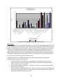
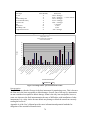
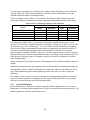
1
Bridge Scour Monitoring
Technologies: Development
of Evaluation and Selection
Protocols for Application on
River Bridges in Minnesota
Jeff Marr, Principal Investigator
St. Anthony Falls Laboratory
University of Minnesota
March 2010
Research Project
Final Report #2010-14
Technical Report Documentation Page
1. Report No.
2.
3. Recipients Accession No.
MN/RC 2010-14
4. Title and Subtitle
5. Report Date
Bridge Scour Monitoring Technologies: Development of
Evaluation and Selection Protocols for Application on River
Bridges in Minnesota
March 2010
7. Author(s)
8. Performing Organization Report No.
6.
Matthew Lueker, Jeff Marr, Chris Ellis, Vincent Winsted,
Shankar Reddy Akula
9. Performing Organization Name and Address
10. Project/Task/Work Unit No.
St. Anthony Falls Laboratory
University of Minnesota
2 3rd Ave SE
Minneapolis, MN 55414
11. Contract (C) or Grant (G) No.
(c) 89261 (wo) 112
12. Sponsoring Organization Name and Address
13. Type of Report and Period Covered
Minnesota Department of Transportation
Research Services Section
395 John Ireland Boulevard, Mail Stop 330
St. Paul, MN 55155
Final Report
14. Sponsoring Agency Code
15. Supplementary Notes
http://www.lrrb.org/pdf/201014.pdf
The Scour Monitoring Decision Framework Excel workbook affiliated with this project can be found:
http://www.safl.umn.edu/publications/software.html
16. Abstract (Limit: 250 words)
Bridge failure or loss of structural integrity can result from scour of riverbed sediment near bridge abutments or
piers during high-flow events in rivers. In the past 20 years, several methods of monitoring bridge scour have been
developed spanning a range of measurement approaches, complexities, costs, robustness, and measurement
resolutions. This project brings together the expertise of Minnesota Department of Transportation (Mn/DOT)
bridge engineers and researchers, university hydraulic and electrical engineers, field staff, and inspectors to take the
first steps toward development of robust scour monitoring for Minnesota river bridges. The team worked with
Mn/DOT engineers to identify variables of scour critical bridges that affect the application of scour monitoring
technology. The research team will used this information to develop a Scour Monitoring Decision Framework
(SMDF) that will aid Mn/DOT in selecting the best technologies for specific sites. The final component of the
project will involve testing the SMDF on five bridges in a case-study type demonstration; work plans for two of the
sites were developed for demonstration of deployed instrumentation.
17. Document Analysis/Descriptors
18. Availability Statement
Scour, Bridge, Monitoring, Remote, Stream instability, Streams,
Decision support systems, Decision framework
No restrictions. Document available from:
National Technical Information Services,
Springfield, Virginia 22161
19. Security Class (this report)
20. Security Class (this page)
21. No. of Pages
Unclassified
Unclassified
193
22. Price
Bridge Scour Monitoring Technologies:
Development of Evaluation and Selection Protocols for
Application on River Bridges in Minnesota
Final Report
Prepared by:
Matthew Lueker
Jeff Marr
Chris Ellis
St. Anthony Fall Laboratory
University of Minnesota
Vincent Winsted
Shankar Reddy Akula
Department of Electrical & Computer Engineering and Technology
Minnesota State University, Mankato
March 2010
Published by:
Minnesota Department of Transportation
Research Services Section
395 John Ireland Boulevard, MS 330
St. Paul, Minnesota 55155-1899
This report represents the results of research conducted by the authors and does not necessarily represent the views
or policies of the Minnesota Department of Transportation, the University of Minnesota, or Minnesota State
University, Mankato. This report does not contain a standard or specified technique.
The authors, the Minnesota Department of Transportation, the University of Minnesota, and Minnesota State
University, Mankato do not endorse products or manufacturers. Any trade or manufacturers’ names that may appear
herein do so solely because they are considered essential to this report.
Acknowledgments
We would like to acknowledge the hydraulics division at the Minnesota Department of
Transportation (Mn/DOT) bridge department for its help updating the project team on bridge
design and conveying real world situations and concerns that affected the result of this project.
This includes Andrea Hendrickson, Lisa Sayler, Petra DeWall, Bonnie Peterson, and Nicole
Danielson-Bartelt.
We would also like to thank Eric Evens and Scott Morgan of the Rochester and Mankato
Mn/DOT districts, respectively, for giving insights into scour monitoring at the field level. Their
advice led to better understanding of problems involved in scour monitoring and issues that are
critical for the success of scour monitoring.
We also thank the rest of the members of the technical advisory panel, Leonard Palek and
Jennifer Zink, and our administrative liaison, Shirlee Sherkow.
Finally, we would like to thank the manufacturers for their time explaining products to the
research team and other state agencies that provided their views, methods, and experiences with
regard to fixed scour monitoring devices.
Table of Contents
Chapter 1 Introduction ................................................................................................................. 1 Chapter 2 Literature Review........................................................................................................ 2 2.1 Introduction ..................................................................................................................... 2 2.1.1 FHWA Literature Specific to Fixed Scour Monitoring .......................................... 2 2.2 FHWA Literature Specific to Stream Stability and Scour at Waterway Crossings ........ 5 2.3 Instrument Specific Literature ........................................................................................ 6 2.4 Implementation of Fixed Scour Monitoring ................................................................... 8 2.5 Ongoing Research at Other DOTs .................................................................................. 9 Chapter 3 River, Bridge, and Scour Characterization ............................................................... 10 3.1 Introduction ................................................................................................................... 10 3.2 Flow Conditions ............................................................................................................ 10 3.2.1 Local Bridge Hydraulics ....................................................................................... 10 3.2.2 River Morphology................................................................................................. 11 3.3 Bridge Geometry........................................................................................................... 12 3.3.1 Deck Plan .............................................................................................................. 13 3.3.2 Superstructure ....................................................................................................... 13 3.3.3 Pier Geometry ....................................................................................................... 13 3.3.4 Abutment Geometry.............................................................................................. 15 3.4 Non-Hydraulic Bridge Conditions ................................................................................ 16 3.5 Bed Material.................................................................................................................. 17 3.5.1 Surface Material .................................................................................................... 17 3.5.2 Subsurface Material .............................................................................................. 17 3.5.3 Riprap/Countermeasure Type and Location ......................................................... 17 3.6 Scour Characterization .................................................................................................. 17 3.6.1 Major Types of Scour ........................................................................................... 17 3.6.2 Failure Modes Caused by Scour ........................................................................... 20 3.7 Mn/DOT Resources for Trunk Highway (T.H.) Bridges.............................................. 20 3.8 River Monitoring Resources ......................................................................................... 21 Chapter 4 Assessment of Key Monitoring Installations ............................................................ 22 4.1 Introduction ................................................................................................................... 22 4.2 Minnesota Fixed Scour Monitoring Installations ......................................................... 22 4.2.1 Bridge 74004......................................................................................................... 22 4.2.2 Bridge 23015......................................................................................................... 24 4.2.3 Bridge 9003........................................................................................................... 27 4.2.4 Lessons Learned.................................................................................................... 29 4.3 Out-of-State Fixed Scour Monitoring Installations ...................................................... 29 4.3.1 Wisconsin.............................................................................................................. 30 4.3.2 California .............................................................................................................. 30 4.3.3 New York .............................................................................................................. 31 4.3.4 Alaska ................................................................................................................... 31 4.3.5 Washington ........................................................................................................... 32 4.3.6 Maryland ............................................................................................................... 32 4.3.7 Vermont ................................................................................................................ 32 4.3.8 Texas ..................................................................................................................... 33 4.3.9 Nevada .................................................................................................................. 33 4.3.10 Oregon................................................................................................................... 34 4.4 Other Assessments ........................................................................................................ 34 4.5 Overall Review of Fixed Scour Monitoring Instrumentation ....................................... 34 4.6 Contacts......................................................................................................................... 37 Chapter 5 Characterization of Fixed Scour Monitoring Technologies...................................... 39 5.1 Introduction ................................................................................................................... 39 5.2 Attributes....................................................................................................................... 39 5.2.1 Sensor Attributes................................................................................................... 40 5.2.2 Sensor – Datalogger Interface............................................................................... 42 5.2.3 Datalogger – Personnel Interface .......................................................................... 43 5.2.4 Power .................................................................................................................... 44 5.2.5 Installation............................................................................................................. 45 5.2.6 Cost ....................................................................................................................... 46 5.2.7 Lifespan................................................................................................................. 47 5.2.8 Serviceability ........................................................................................................ 47 5.3 Scour Monitoring Devices ............................................................................................ 48 5.3.1 Sonar Devices ....................................................................................................... 48 5.3.2 Magnetic Sliding Collars ...................................................................................... 48 5.3.3 Float-Out Devices ................................................................................................. 49 5.3.4 Tilt Angle/Vibration Sensor Devices .................................................................... 49 5.3.5 Sounding Rods ...................................................................................................... 49 5.3.6 Piezoelectric Film Devices ................................................................................... 49 5.3.7 Time Domain Reflectometry ................................................................................ 50 5.4 Characterization Issues ................................................................................................. 50 Chapter 6 Scour Monitoring Decision Framework ................................................................... 52 Chapter 7 Application of Scour Monitoring Decision Framework to Five Minnesota Bridge
Sites
................................................................................................................................... 53 7.1 Bridge 6468................................................................................................................... 54 7.1.1 Data Entry ............................................................................................................. 55 7.1.2 Results ................................................................................................................... 55 7.2 Bridge 6868/6869.......................................................................................................... 57 7.2.1 Data Entry ............................................................................................................. 59 7.2.2 Results ................................................................................................................... 59 7.3 Bridge 07011................................................................................................................. 61 7.3.1 Data Entry ............................................................................................................. 62 7.3.2 Results ................................................................................................................... 63 7.4 Bridge 07038................................................................................................................. 65 7.4.1 Data Entry ............................................................................................................. 66 7.4.2 Results ................................................................................................................... 67 7.5 Bridge 23015................................................................................................................. 71 7.5.1 Data Entry ............................................................................................................. 73 7.5.2 Results ................................................................................................................... 73 7.6 Overview of Application to Bridges ............................................................................. 77 Chapter 8 Work Plans for Fixed Scour Monitoring Deployment at Two Bridges .................... 79 8.1 Bridge 07011................................................................................................................. 79 8.1.1 Deployment Overview .......................................................................................... 79 8.1.2 Sonar and Stage Sensor Assembly ........................................................................ 80 8.1.3 Conduit.................................................................................................................. 81 8.1.4 Datalogger Enclosure ............................................................................................ 81 8.1.5 Installation............................................................................................................. 82 8.1.6 System Construction and Programming ............................................................... 83 8.1.7 System Maintenance ............................................................................................. 84 8.1.8 Total Costs ............................................................................................................ 85 8.1.9 Additional Design Details ..................................................................................... 85 8.2 Bridge 23015................................................................................................................. 86 8.2.1 Deployment Overview .......................................................................................... 86 8.2.2 Sonar and Stage Sensor Assembly ........................................................................ 87 8.2.3 Conduit.................................................................................................................. 88 8.2.4 Float-Out Devices ................................................................................................. 88 8.2.5 Datalogger Enclosure ............................................................................................ 88 8.2.6 Installation............................................................................................................. 89 8.2.7 System Construction and Programming ............................................................... 90 8.2.8 System Maintenance ............................................................................................. 91 8.2.9 Total Costs ............................................................................................................ 92 8.3 Additional Design Details ............................................................................................. 92 Chapter 9 Conclusions ............................................................................................................... 94 Chapter 10 Recommendations for Future Research in Fixed Scour Monitoring .................... 95 References ..................................................................................................................................... 96 Appendix A Synopsis of Scour Critical Trunk Highway Bridges in Minnesota Appendix B Diagrams of Bridge Site Attributes Appendix C Scour Monitoring Decision Framework User Manual List of Tables
Table 3.1: Stream classifications .................................................................................................. 11 Table 3.2: River flow habits.......................................................................................................... 11 Table 3.3: Pier types ..................................................................................................................... 13 Table 3.4: Pier foundations ........................................................................................................... 13 Table 3.5: Abutment types ............................................................................................................ 15 Table 3.6: Abutment foundation types.......................................................................................... 15 Table 3.7: Bridge/river information available at Mn/DOT for trunk highway bridges ................ 21 Table 3.8: Resources for river discharge and stage ...................................................................... 21 Table 4.1: Summary of costs and attributes for fixed scour monitoring equipment reported during
assessment task ............................................................................................................................. 36 Table 5.1: Common fixed scour instrumentation attributes.......................................................... 51 Table 7.1: Selected bridges for SMDF demonstration.................................................................. 53 Table 7.2: Demonstration bridge characteristics .......................................................................... 53 Table 7.3: Summary of bridges for SMDF application and respective user-selected
instrumentation ............................................................................................................................. 78 Table 8.1: Sensor enclosure components for Bridge 07011 ......................................................... 80 Table 8.2: Sensor-datalogger connection components for Bridge 07011 ..................................... 81 Table 8.3: Datalogger enclosure components for Bridge 07011 .................................................. 82 Table 8.4: Estimated installation cost for Bridge 07011............................................................... 83 Table 8.5: Estimated hours for initial system construction for Bridge 07011 .............................. 83 Table 8.6: Power consumed/generated by system components .................................................... 84 Table 8.7: Estimated maintenance costs and hours ...................................................................... 85 Table 8.8: Sensor enclosure components for Bridge 23015 ......................................................... 87 Table 8.9: Sensor-datalogger connection components for Bridge 23015 ..................................... 88 Table 8.10: Datalogger enclosure components for Bridge 23015 ................................................ 89 Table 8.11: Estimated installation cost for Bridge 23015............................................................. 90 Table 8.12: Estimated hours for initial system construction for Bridge 23015 ............................ 90 Table 8.13: Power consumed/generated by system components .................................................. 91 Table 8.14: Estimated maintenance costs and hours .................................................................... 92 List of Figures
Figure 2.1: Flow chart for scour and stream analysis and evaluation............................................. 5 Figure 3.1: Solid, column, and pile bent pier types, respectively ................................................. 14 Figure 3.2: Generic upstream pier profile ..................................................................................... 15 Figure 3.3: Pier scour depth in a sand bed stream as a function of time ...................................... 18 Figure 3.4: Schematic representation of scour at a cylindrical pier .............................................. 19 Figure 3.5: Schematic representation of abutment scour .............................................................. 20 Figure 4.1: Profile view of Bridge 74004 installation .................................................................. 23 Figure 4.2: Installed manual sliding collar on Bridge 74004........................................................ 24 Figure 4.3: Point bar before deposition around pier 4 - looking west (unknown date) ................ 25 Figure 4.4: Point bar after deposition around pier 4 - looking west (January 2009) .................... 25 Figure 4.5: Bank erosion due to channel migration - looking east (note scale of person)............ 26 Figure 4.6: Profile view of Bridge 23015 installation .................................................................. 27 Figure 4.7: Installed manual sliding collar monitor on Bridge 23015 with debris damage.......... 27 Figure 4.8: Profile view of Bridge 9003 installation .................................................................... 28 Figure 4.9: Installed manual sliding collar on Bridge 9003.......................................................... 29 Figure 7.1: Bridge 6468 - aerial view from Google Earth ............................................................ 54 Figure 7.2: Bridge 6468 - upstream left abutment ........................................................................ 54 Figure 7.3: Bridge 6468 - west abutment results .......................................................................... 56 Figure 7.4: Bridge 6468 - west abutment characteristic results .................................................... 56 Figure 7.5: Bridge 6868/6869 - aerial view from Google Earth ................................................... 58 Figure 7.6: Bridge 6868/6869 - upstream pier profiles looking west ........................................... 58 Figure 7.7: Bridge 6868/6869 - sand covered riprap on east abutment ........................................ 58 Figure 7.8: Bridge 6868 – pier 1 results ....................................................................................... 60 Figure 7.9: Bridge 6868 – pier 1 characteristic results ................................................................. 60 Figure 7.10: Bridge 07011 - aerial view from Google Earth ........................................................ 62 Figure 7.11: Bridge 07011 - upstream profiles of piers 3 through 6 ............................................ 62 Figure 7.12: Bridge 07011 – pier 4 results ................................................................................... 63 Figure 7.13: Bridge 07011 – pier 4 characteristic results ............................................................. 64 Figure 7.14: Bridge 07038 - aerial view from Google Earth ........................................................ 66 Figure 7.15: Bridge 07038 - upstream pier profiles ...................................................................... 66 Figure 7.16: Bridge 07038 – pier 1 results ................................................................................... 67 Figure 7.17: Bridge 07038 – pier 1 characteristic results ............................................................. 68 Figure 7.18: Bridge 07038 – west abutment results ..................................................................... 69 Figure 7.19: Bridge 07038 – west abutment characteristic results ............................................... 70 Figure 7.20: Bridge 23015 - aerial view from Google Earth ........................................................ 72 Figure 7.21: Bridge 23015 - upstream pier profiles and debris .................................................... 72 Figure 7.22: Bridge 23015– pier 5 results .................................................................................... 74 Figure 7.23: Bridge 23015 – pier 5 characteristic results ............................................................. 74 Figure 7.24: Bridge 23015– north abutment results ..................................................................... 76 Figure 7.25: Bridge 23015 – north abutment characteristic results .............................................. 76 Figure 8.1: Bridge 07011 - pier 4 sonar installation ..................................................................... 80 Figure 8.2: Bridge 23015 - pier 5 sonar installation ..................................................................... 87 Executive Summary
Streams at waterway bridges present significant challenges for bridge engineers. They create
highly variable situations and can damage bridge structures in many different ways. Broadly,
these mechanisms involve scour and stream instability. Scour is the erosion of bed material due
either to bridge foundations set in the flow, or stream constriction at bridge sites. Stream
instability involves the lateral or vertical movement of a stream over time. According to the
National Cooperative Highway Research Program (NCHRP) Report 396, Instrumentation for
Measuring Scour at Bridge Piers and Abutment, (Lagasse et al, 1997, p. 4), these stream related
issues account for 60% of bridge failures in the United States. Countermeasures to mitigate these
issues involve either physical means, such as riprap or monitoring. In cases where physical
countermeasures are cost prohibitive, monitoring may be used as an acceptable alternative.
Monitoring can be further subdivided into portable monitoring or fixed monitoring. Portable
monitoring involves manually measuring stream bed levels at structures, whereas fixed
monitoring involves the deployment of a device to record scour depths that are later retrieved.
The goal of this work is to aid bridge engineers with proper selection of the numerous fixed
scour monitoring instruments available.
The final product of this work is the Scour Monitoring Decision Framework (SMDF). This
decision-making tool addresses one of the major problems with regard to fixed scour monitoring
instrumentation. NCHRP Report 396 best describes the issue: “no single methodology or
instrument for measuring scour at bridge piers and abutments can be used to solve the scour
measuring problems for all situations encountered in the field” (p. 84). The report further
describes this issue as an area for future research. The SMDF is a Visual Basic for Applications
(VBA) enabled Excel workbook that accepts site-specific information about one bridge site at a
time. This information includes details on bridge, stream, and scour, and then compares the
information to critical characteristics for fixed scour monitoring equipment. The output is a list
ranking the instruments in the SMDF and an overview of the characteristics illustrating the effect
of each on the score. After entering the required information, the user has a good familiarity with
the site and, along with the output of the SMDF, can more confidently select the instrument best
suited for the site.
The methodology used to gather information for construction of the SMDF included the
following:
•
•
•
•
A literature review
Bridge/stream/scour characterization
Previous installation assessments
Fixed scour monitoring instrumentation characterization
The literature review included documents on scour, specific instruments, and implementation.
One of the largest problems with fixed scour monitoring identified in the literature was the
ongoing maintenance systems required. The majority of the successful long-term deployments
were affiliated with research projects; this allowed continual attention to the system. Another
major problem identified in the literature review was woody river debris that damaged the
systems.
The bridge/stream/scour characterization was organized and designed to utilize information
readily available at Minnesota Department of Transportation (Mn/DOT). These sources of
information include bridge plans and scour calculations.
The assessment of previously installed fixed scour monitoring deployments included all those in
Minnesota and significant installations in the rest of the United States. These assessments agreed
with the conclusions found in the literature review.
The characterization of fixed scour monitoring devices resulted in 24 critical attributes for the
devices. These were selected to be as broad as possible to make them applicable to both current
instruments and instruments developed in the future. This allows comparison between new
instruments and those currently used within the framework.
The SMDF receives information from the user and outputs a list of the suitability for each
instrument for the bridge site currently of interest, as well as potential issues with deployment.
This list of issues includes both those specific to a particular instrument, and overall to the site.
First, it compares the user input to instrument characteristics. The second step of the decision
framework compares the instrument characteristics to each of the instruments currently entered
into the SMDF. The instruments are then output according to their percentage format scores. The
framework calculates the percentage by normalizing each instrument’s score to the score of a
hypothetical ideal instrument that satisfies all of the instrument characteristics for the bridge site.
The user then selects an instrument and the SMDF illustrates the characteristics of that
instrument in a bar graph. This graph shows the importance of each characteristic and whether
the selected instrument satisfies the characteristic. This graph can be used with documentation in
the user guide to determine possible mitigation techniques for weaknesses of the user-selected
instrument.
The SMDF was applied to five demonstration sites. These sites ranged from a two-lane singlespan bridge to an interstate bridge. The bridges selected provide a wide range of situations to test
the SMDF. All of the bridges selected have a high likelihood for scour according to Mn/DOT.
The results presented by the SMDF matched well with intuitive results, and the framework
successfully conveys site-specific issues to the user through its output.
Work plans were developed for two of the demonstration sites. This portion of the project
illustrates the next steps if deployment of a site is further investigated. The work plans include
example drawings of equipment installation and items required for installation, along with
pricing. The total costs for each of the two installations are estimated to be $30,100 and $37,100.
Both work plans involve installation of two sonar devices, each monitoring a single pier. The
more expensive installation includes float-out devices for monitoring an abutment. These costs
include significant labor costs associated with personnel hours for initial sensor setup and
programming. These costs will go down in similar systems installed later because the
programming will be reusable. The installation costs match well with other estimates for these
types of instruments. Yearly maintenance is estimated to be $2,200. The first year likely will
incur more costs as unforeseen issues with the installations are solved.
In conclusion, the Scour Monitoring Decision Framework should be able to help engineers when
selecting or investigating the possibility of using fixed scour monitoring on a bridge site. The
engineers should gain insight into site-specific issues for each bridge from both the output of the
framework as well as the process of entering the necessary input. The results are intuitive and
determine the most critical characteristics of each site. In addition, the SMDF provides warnings
for situations where atypical scour is likely to occur, i.e., high angle of attack of the stream on
the pier.
During application of the SMDF to the demonstration sites, the most common, highest-rated
instrument for monitoring piers were sonar devices, and the most common, highest-rated
instrument for monitoring abutments were float-out devices.
Recommendations for future installations and research include the following four items:
•
Additional deployments: Future deployments will provide the best information on
difficulties that arise with fixed scour monitoring deployments.
•
Collaboration with others: Installations that were part of a larger research effort were
found to be the most successful in the literature review. Finding other parties interested in
field-scale scour studies will help ensure good initial and continued deployments.
•
Additional research into individual sensors: Some instruments have not been widely
used, so additional research focusing on individual instruments may be beneficial. New
instruments are continuously being developed; two examples are tethered float-outs and
Time Domain Reflectometry.
•
Database management: Database management is crucial to the success of deployment
over the long term. Along with telemetry, a good database can provide long-term trends,
near instantaneous readings, and automated error checking.
Chapter 1 Introduction
This report provides a summary of the development of a software-based tool to aid the
evaluation and selection of fixed monitoring technologies for bridge scour. The tool is referred to
as the Scour Monitoring Decision Framework (SMDF). The tool was developed through
collaboration between researchers at the University of Minnesota’s St. Anthony Falls
Laboratory; Minnesota State University, Mankato; and members of the Technical Advisory
Panel (TAP). The TAP included engineers and staff from the Minnesota Department of
Transportation.
This report is organized into chapters that follow the chronological timeline of the project. The
initial phases of the project involved a literature review, assessment of previous deployments,
river/bridge characterization, and instrument characterization. The literature review and
assessment of previous deployments provided the current state of fixed scour monitoring. The
river/bridge characterization and instrumentation characterization sought appropriate attributes
that affect the decision of type fixed scour monitoring for scour critical bridges in Minnesota.
This would be used in the later phases for input into the SMDF tool.
The next phases of the project involved development of the SMDF. The tool was written in
Visual Basic for Applications, provided with Microsoft Excel. A user’s manual was developed to
help provide instruction. Application of the SMDF was performed on five scour critical bridges
to illustrate its use. Finally, two of the application bridges were selected for a more in-depth
development of a fixed scour monitoring plan resulting in workplans.
1
Chapter 2 Literature Review
2.1 Introduction
This literature review provides a summary of relevant scour monitoring literature available at the
time of the study and connects existing technologies, techniques, and experiences to scour
monitoring challenges in Minnesota. Only fixed instrumentation is considered.
This review relies heavily on National Cooperative Highway Research Program (NCHRP)
Reports 396, 397a, 397b, and the monitoring portion (Chapter 7) of Hydraulic Engineering
Circular (HEC)-23. Additionally, sources included in this review cover areas not addressed in the
NCHRP and HEC studies.
The literature review begins with the sections of the Federal Highway Administration (FHWA)
documents listed above that are directly related to fixed monitoring of scour, followed by other
FHWA documents on the broader topic of stream stability and scour at waterway crossings. The
remainder of the review discusses instrument-specific literature and includes an overview of
ongoing research at other Departments of Transportation (DOTs).
2.1.1 FHWA Literature Specific to Fixed Scour Monitoring
A set of three NCHRP reports substantially defined the current state of knowledge as of 1997
regarding fixed bridge scour instrumentation in the U.S. The reports are:
•
•
•
NCHRP Report 396, Instrumentation for Measuring Scour at Bridge Piers and
Abutments
NCHRP Report 397a, Sonar Scour Monitor: Installation, Operation, and Fabrication
Manual
NCHRP Report 397b, Magnetic Sliding Collar Scour Monitor: Installation, Operation,
and Fabrication Manual
The studies were motivated by the Schoharie Creek and Hatchie River bridge failures in New
York and Tennessee, respectively. Both of these bridges failed due to scouring at piers. These
three reports have greatly influenced the history of instrumentation development since their
publication, mostly by selecting sonar and magnetic sliding collars as the most deployable and
reliable monitoring methods.
Instrumentation for Monitoring Scour at Bridge Piers and Abutments, NCHRP Report 396
Authors: Lagasse, P.F., E.V. Richardson, J.D. Schall, and G.R. Price
Performing Organization: Ayres Associates
Sponsoring Organization: Transportation Research Board, National Research Council
Publication Date: 1997
NCHRP Report 396 is an overview of the technologies available at the time of its publication. It
characterizes each technology with regard to cost, feasibility, and applicability to hydraulic,
geomorphic, and structural conditions. A further goal of the study was to find and implement
technologies that were ready for field testing.
2
The report came to three major conclusions:
(I)
Fixed scour monitoring can be categorized into four major groups: sounding rods,
buried or driven rods, sonar, and other buried devices.
It is critically important to develop criteria for successful scour monitoring. These
criteria are based on insights gained by the NCHRP research team while studying and
installing various scour monitoring technologies and included:
(II)
1. Mandatory criteria
• Capability for installation on or near a bridge pier or abutment
• Ability to measure maximum scour depth within an accuracy of +/- 1 ft
• Ability to obtain scour depth readings from above water or from a remote site
• Operable during storm and flood conditions
2. Desirable criteria
• Capability to be installed on most existing bridges or during construction of new
bridges
• Capability to operate in a range of flow conditions
• Capability to withstand ice and debris
• Relatively low cost
• Vandal resistant
• Operable and maintainable by highway maintenance personnel
In the NCHRP studies, both the sonar and sliding collar instruments met all of the
mandatory criteria and most of the desirable criteria. Most of the other devices tested
met the same requirements, but were not as thoroughly tested.
(III)
Selection of a fixed scour monitoring technology should be based on site-specific
conditions. In NCHRP Report 396, the authors conclude that “no single methodology
or instrument for measuring scour at bridge piers and abutments can be used to solve
the scour measuring problems for all situations encountered in the field” (Lagasse, et
al., 1997, p. 84). In addition, one of the suggestions for further study is to provide
better guidance for the selection of appropriate instrumentation for site specific bridge
conditions.
Another suggestion from NCHRP Report 396 was to improve the methods used to estimate the
location of critical scour at bridge sites so that monitoring can be concentrated in that area.
Tables included in Report 396 that are directly applicable to the current work are:
1. Table 2. Comparison of Devices Tested With Mandatory and Desirable Criteria
2. Table 3. Equipment Cost Assuming Basic Level of Functionality (BLF) and Assumed
Level of Research and Development
3. Table 4. Estimated Costs for Scour Measuring Systems
4. Table 5. Applicability to Scour Measuring Device for Pier and Abutment Geometry
5. Table 6. Applicability of Scour Measuring Devices for Flow and Geomorphic Conditions
3
Sonar Scour Monitor – Installation, Operation, and Fabrication Manual, NCHRP Report
397a and Magnetic Sliding Collar Scour Monitor Installation, Operation and Fabrication
Manual, NCHRP Report 397b
Authors: Schall, J.D., G.R. Price, G.A. Fisher, P.F. Lagasse, and E.V. Richardson
Performing Organization: Ayres Associates
Sponsoring Organization: Transportation Research Board, National Research Council
Publication Date: 1997
These reports are manuals for the fabrication, installation, and operation of the two most field
deployable technologies as determined by NCHRP Report 396 - the sonar scour monitor and the
magnetic sliding collar monitor.
Sonar monitoring uses a low-cost, commercially available sonic fathometer pointed at the
locations of anticipated scour or critical failure. The technique can measure an aggrading or
eroding bed. The sonar probe is usually mounted to the sub structure of a bridge and connected
to a datalogger on the bridge deck. NCHRP Report 396a discusses the applicability of this type
of monitoring with regard to environmental and structural factors, and follows with instructions
on installation, operation, maintenance, and data interpretation. General fabrication drawings are
given at the end of the report.
Magnetic sliding collars are collars that slide down a rod driven into the streambed. The collar
sits on the riverbed, and as the local bed erodes, the collar follows the bed. This method of
monitoring only measures maximum scour depth. The system may be automated or read
manually. With the automated setup, magnetic switches inside of the driven rod locate the collar
and a datalogger records the collar’s location. In the manual setup, a magnetic switch is lowered
until it is triggered by the collar. NCHRP Report 396b follows the same format as 396a by
discussing the applicability, installation, operation, maintenance, and data interpretation of the
magnetic sliding collar. General fabrication drawings are also given at the end of the report.
Bridge Scour and Stream Instability Countermeasures – Experience, Selection, and Design
Guidance, HEC-23, FHWA NHI 01-003
Authors: Lagasse, P.F., L.W. Zevenbergen, J.D. Schall, and P.E. Clopper
Performing Organization: Ayres Associates
Sponsoring Organization: Federal Highway Administration, U.S. Department of Transportation
Publication Date: 2001
Many of the observations and results contained in NCHRP Reports 396, 397a, and 397b are
summarized in Chapter Seven of Hydraulic Engineering Circular 23, Bridge Scour and Stream
Instability Countermeasures. However, some additional content not in the 1997 NCHRP reports
is added. This new information describes field results from scour monitoring sites located in
California, Arizona, and Nevada installed from 1997-1998. These installations used previously
untested methods including call-outs (automated phone calls to management personnel triggered
at a set scour depth), multiple sonar setups, and float-out devices. A February 1998 flood event
in California scoured out and released buried float-out devices and triggered the call-out event.
The techniques worked as designed, but did not reach personnel immediately due to the event
occurring outside of normal business hours (Lagasse et al, 2001).
Three tables directly related to fixed scour monitoring are also included in Chapter 7 of HEC23. These tables provide a summary of key information related to the selection and performance
of fixed scour monitoring technologies. The tables include:
4
1. Table 7.1. Comparison of Devices Tested with Mandatory and Desirable Criteria
2. Table 7.4. Fixed Instrumentation Summary
3. Table 7.6. Estimated Cost Information
These tables are similar to those in NCHRP Report 396, but with updates. Other chapters of
HEC-23 should be consulted if an installation of fixed scour monitoring technology is to be used
in combination with, or to evaluate the effectiveness of, other countermeasure methods.
2.2 FHWA Literature Specific to Stream Stability and Scour at Waterway
Crossings
HEC-23 is part of a larger set of HEC documents written to provide guidance on bridge scour
and stream stability issues. The flowchart in figure 2.1, taken from Chapter 7 of HEC 23, shows
the links between HEC-20, -18, and -23. HEC-20, “Stream Stability and Highway Structures”
focuses on stream classification and stability. HEC-18, “Evaluation of Scour at Bridges” focuses
on hydraulic analysis as it relates to scour. HEC-20 and HEC-18 do not specifically address
scour monitoring, but provide important information and engineering tools for estimating the
geomorphic change and scour development at bridges. These are essential components of
effective scour monitoring design, as choices need to be made that can incorporate long-term
changes in the river bed cross section and identify specific locations of local scour.
Figure 2.1: Flow chart for scour and stream analysis and evaluation
Reprinted with Permission of the Department of Transportation - Federal Highway Administration,
from Lagasse, et al., 2001a
5
Stream Stability at Highway Structure, HEC-20, FHWA NHI 01-002
Authors: Lagasse, P.F., J.D. Schall, and E.V. Richardson
Performing Organization: Ayres Associates
Sponsoring Organization: Federal Highway Administration, US Department of Transportation
Publication Date: 2001
HEC-20 covers stream stability and presents detailed information including influences of bed
material, the affects of local bends, and head and tail water control on bed erosion and
deposition. The lateral and vertical stability of a channel directly affects the successful
implementation of a scour monitoring plan. For fixed scour monitoring design, this information
is necessary to ensure selected scour instrumentation is effective over its entire lifetime,
regardless of changes in stream morphology.
Evaluating Scour at Bridges HEC-18, FHWA NHI 01-001
Authors: Richardson, E.V. and S.R. Davis
Performing Organization: Ayres Associates
Sponsoring Organization: Federal Highway Administration, US Department of Transportation
Publication Date: 2001
HEC-18 extensively covers the calculation of scour depth for a number of bridge conditions. The
document addresses the fundamentals of scour and concepts of total scour, channel
degradation/aggradation, contraction scour, asymmetric scour due to river bends, and local scour.
It also provides an analysis with detailed calculations or other recommendations for determining
the magnitude of each component of scour. Using this procedure, potential scour critical areas
can be determined by finding the cumulative scour. This site-specific information is important to
fixed scour monitoring design as the expected depth of scour and the components of that scour
may affect instrumentation selection. The information needed for these scour calculation
procedures is important to know because it can be assumed the DOT still has the information and
it may be used to help choose fixed monitoring instrumentation.
Precise locations of maximum scour are difficult to determine beyond basic bridge and pier
geometries. These basic configurations include local scour directly upstream of a pier aligned
with the flow direction and the upstream toe of a sloping abutment. For more complex
geometries, additional information is needed to determine the correct location to monitor.
2.3 Instrument Specific Literature
A major conclusion of NCHRP Report 396 is that no one monitoring system can be expected to
work in every situation. The sliding collar and sonar devices have seen the most usage in field
installations due to the findings of NCHRP Report 396. Listed below are publications on other
specific instrumentation.
Evaluation of Brisco™ Scour Monitors
Authors: Marks,V.J
Sponsoring Organization: Iowa Department of Transportation & Federal Highway
Administration
Publication Date: 1993
The Brisco™ monitor is a sliding rod device which measures scour using a sounding rod with a
footplate. The sounding rod is guided by a hollow cylinder mounted on the bridge structure. Like
the sliding collar, this type of monitor can only record the history of the lowest bed elevation.
6
Very poor results with the Brisco™ automated sliding rod system were reported. The most
severe problems were due to poor electronic sensing of the instrument position. An enlarged
footplate was needed due to penetration problems in sand beds. The document suggests that
sensor performance may improve in coarse bed streams, however there has been little
documented testing of the device.
Understanding the Lowering of Beaches in Front of Coastal Defence Structures, Phase 2,
Technical Report, HR Wallingford, UK
Authors: Sutherland, J., et al
Performing Organization: HR Wallingford
Sponsor Organization: Department of Environment, Food and Rural Affairs, UK
Publication Date: 2006
This document describes a vertical 1-D array of piezoelectric devices attached to a single driven
or buried rod. The sensors generate a voltage when moved by flowing water, but are quiescent
when buried. Beginning in 1996, these devices were used for three years to successfully track the
tidal effects of cyclic scour at the toe of a coastal wall in the UK. Individual sensors within the
array started to fail after one year of use.
Laboratory Investigation of Time – Domain Reflectometry System for Monitoring Bridge
Scour
Authors: Yankielun, N.E. and L. Zabilansky
Publication Date: 1999
Laboratory research on a time domain reflectometry system designed to determine a bed – water
interface was conducted. The technique works by measuring the return of an electromagnetic
pulse sent through a driven or buried rod. Each change in medium through which the signal
travels returns a portion of the signal and the distance is proportional to the return time. Errors of
scour depth of 5% of the total sensor length were reported in the controlled test setup. Problems
involving signal attenuation over long wire runs and sensor lengths were anticipated in potential
field applications. Installation requires burying or driving rods into the bed.
The Pneumatic Scour Detection System
Authors: Mercado, E.J. and J.R. Rao
Conference: Symposium on the Application of Geophysics to Engineering and Environmental
Problems
Conference Date: April 2006
Laboratory design and a field installation in Oregon are documented. This system has no moving
parts and measures the rate of pressure decay in tubes initially pressurized. The outlets are
located at various depths in the water-bed column next to a structure. Outlets located in bed
material exhibit much slower pressure decay times compared to those in the water column. A
field device was installed in June 1997. The total length of the sensor was 55 feet with 22 feet
driven below the bed surface. The instrument worked as expected at installation, but water
infiltration into tubes caused problems. This was remedied with longer purge times.
Measurements require compressed air at the site.
7
Monitoring Bridge Scour with Buried Transmitters, FHWA/CA/TL-95/16
Authors: Winter, Walter A
Sponsoring Organization: California Department of Transportation
Publication Date: 1995
Buried transmitters are essentially weighted tip switches buried at known elevations and activate
when unburied by scour. This report roughly outlines a method to wirelessly monitor buried
transmitters which have a battery lifetime of at least five years. Installation involves boring a
hole and burying the sensors and a low frequency transponder at probable scour locations. The
appendix of the report contains a very technical proposal by a firm which thoroughly covers the
theory of operation. Each buried setup would have three tip sensors in a column that sends a
signal to a transponder, which then would relay the information wirelessly to a receiver every
five minutes. The cost of each column setup in 1997 was estimated to be $2000.
2.4
Implementation of Fixed Scour Monitoring
Fixed scour monitoring is an active area of research and development. Below is a list of the work
underway at the time of the study was conducted.
Monitoring Scour Critical Bridges, NCHRP Synthesis 396
Authors: Hunt, B.
Sponsoring Organization: National Cooperative Highway Research Program
Publication Date: 2009
This report documents the extent of fixed scour monitoring system usage in the United States.
Surveys were sent out to all states and responses detailed 56 sites where fixed monitoring has
been implemented. The survey questionnaire covered many aspects of the installations, including
problems encountered in system implementation. The most common problems associated with
implementation were floating debris, cost of maintenance, and information transfer to
appropriate personnel. The document continues with case studies of scour monitoring system
implementation and a discussion of new instrumentation and data quality requirements. The
survey portion of this report is extremely informative as it assigns values to variables such as the
importance of debris presented in the form of respondent percentages.
Bridge Foundation Scour Monitoring: A Prioritization and Implementation Guideline
Authors: Haas, C., and J.Weissman
Sponsoring Organization: University of Texas at Austin
Publication Date: 1999
A program was developed to prioritize which bridges in Texas would benefit the most from fixed
scour monitoring. The program did not evaluate what type of monitoring to implement, but
which bridges in the Texas database required scour monitoring the most. Pre-existing scour
monitoring prioritization programs were not compatible with the Texas DOT database or did not
correlate well with manual prioritizations completed by engineering staff. The report provides an
overview of a new bridge prioritization scheme and concludes with an overview of
instrumentation types and implementations in Texas.
8
Bridge Scour Monitoring Methods at Three Sites in Wisconsin, USGS Open File Report
2005-1374
Authors: Walker, John F., and Peter E. Hughes
Sponsoring Organization: US Geologic Survey, Wisconsin Department of Transportation,
Marathon and Jefferson County Highway Departments, Wisconsin
Publication Date: 2005
This 2005 report covers three installations in Wisconsin; one utilizing a permanent drop wire
deployment that requires on-site personnel to perform the measurements, and two which utilize
data-logging sonar. One of the sonar monitors was set up to download real-time scour data to a
USGS website. The sonar installations failed at first due to debris, but later attempts proved very
successful.
2.5 Ongoing Research at Other DOTs
There is currently ongoing research at other DOTs on fixed scour monitoring. The states which
have similar ongoing research are:
•
•
•
•
•
•
•
Texas, “Real-time Monitoring of Scour Events Using Remote Monitoring Technology,”
estimated end date: August 31, 2010
Arkansas, “Development of a Bridge Scour Monitoring System,” active
New Hampshire, “Scour Monitoring Implementation Study,” end date: December 31,
2007
Vermont, “Continuously Monitored Scour,” estimated end date: September 30, 2010
Hawaii, “Instrumentation and Monitoring of Sand Plugging and Bridge Scour at Selected
Streams in Hawaii,” end date: December 31, 2006
Indiana, “Scour Monitoring for Indiana Bridges,” completed
Indiana, “Scour Monitoring of Bridge Piers in Indiana,” active
9
Chapter 3 River, Bridge, and Scour Characterization
3.1 Introduction
Proper characterization of a waterway bridge site is essential to select appropriate fixed scour
monitoring instrumentation. Each site characterization should result in an evaluation of the
following details:
1.
2.
3.
4.
5.
6.
7.
8.
9.
Location and type of scour likely to cause bridge failure
Depth of scour likely to cause bridge failure
Hydrological behavior of river at the site (advanced warning)
Implementation goals in addition to public safety
Potential attachment points for sensors and wiring runs
Difficulty and cost of installation
Accessibility to installed equipment
Hazards which would cause damage to monitoring systems
Situations which would cause failure of monitoring systems
The information needed to evaluate these details comes from a combination of site attributes.
The Scour Monitoring Decision Framework (SMDF) developed in this study evaluates attributes
and determines the relevance of each to the above details. Much of the information needed for
the SMDF is readily available to DOTs due to the extensive use of the scour calculation
procedures as prescribed in HEC-18, “Evaluating Scour at Bridges.” The required inputs and
results of these scour calculations provide a large amount of critical site attributes. However, this
information is mostly limited to local hydraulic variables and further information, such as bridge
geometry, are required site for proper selection of fixed scour monitoring instrumentation. The
following sections list the waterway bridge attributes relevant to this selection process.
3.2 Flow Conditions
Flow conditions are separated into two major categories: hydraulic parameters that are locally
responsible for scour, and overall river morphology. Local bridge hydraulics consists of flow
velocity, direction, depth, and the presence of entrained air or other material close to the bridge
structure. River morphology consists of larger scale parameters such as river type, long-term
channel migration, the presence of upstream or downstream tributaries, debris loading, and
channel curvature at the bridge location.
3.2.1 Local Bridge Hydraulics
Local bridge hydraulics describes the flow that moves bed material during the scour process.
Water depth and velocity are the two most important characteristics of this flow with regard to
local scour. Generally, as the depth decreases and approach velocity increases, the flow becomes
more turbulent when encountering an obstruction. This in turn increases vortices and bed
scouring.
Depth and velocity also affect other hydraulic aspects of a bridge site besides local scour. The
water depth relative to the bridge geometry can have significant effects. If the water surface rises
above the low chord of the bridge, the additional component of a plunging pressure flow can
deepen the maximum scour depth and drag debris deeper into the flow. High water velocities
produce significant drag forces on fixed monitoring related structures. Among other effects,
10
these forces may cause removal or flow induced vibrations of instrumentation, resulting in
monitoring system failure.
The amount of entrained air and debris in the flow are examples of other characteristics that
affect the use of fixed scour monitoring instrumentation. Sonar does not work in bubbly flows
and debris in the water may also have adverse affects on sonar and other types of
instrumentation.
3.2.2 River Morphology
River morphology encompasses a group of characterizations affecting any waterway crossing.
The two most important river morphology parameters are stream classification and flow habit.
Table 3.1: Stream classifications
Stream Classification
Straight
Stable
Active
Meandering
Braided
Anabranching
Table 3.2: River flow habits
Flow Habit
Intermittent
Perennial, but Flashy
Perennial
Stream classification focuses on the local stream morphology of the stream site. The majority of
streams in Minnesota are either straight or meandering. Meandering streams are subdivided into
stable and active. In this project, a stream is considered stable if the river does not move during
the anticipated lifespan of the bridge. Large, old trees along the riverbank are good indicators of
a stable channel. Braided and anabranching streams are not common in Minnesota and are not
considered in this study.
Most rivers in Minnesota are classified as perennial. Flashy indicates that a complete event
hydrograph occurs within a few days and stream flow is not predictable beyond that same
timeframe. A steep stream emptying a quickly draining watershed is a general description of a
flashy river; however, historical accounts are the best method of determination. Intermittent
streams normally become completely dry at some point during an annual cycle. Ephemeral
streams are included in intermittent stream classification for purposes of clarification.
Other major characteristics derived from river morphology are curvature, lateral movement, and
stream stability. Curvature is a local variable at the bridge site that describes how much the
stream direction is turning. Erosion on the outer bank of the bend and deposition on the inner
bank is a general trait in meandering rivers and can have devastating effects on a bridge if it
crosses at a bend. Additionally, lateral migration adversely affects structures by attacking
portions of the bridge not initially designed to be threatened by erosion, changing the angle of
attack on piers and abutments, and/or contracting the waterway with deposition on the inner
bank.
11
Vertical stability of a river at a bridge crossing appears in the form of overall channel bed
degradation or aggradation. Changing headwater, tailwater, and/or sediment loading conditions
cause these changes in bed elevation. The time scale of these effects can be long (decades) or
short (days) depending on the cause. Short-term changes generally result from a nearby structural
failure, such as check dam washout, or an abrupt avulsion or cut-off resulting in an overall
shorter reach of river. These types of abrupt changes are not common, but potential for these
occurrences should be noted for the site. Long-term channel bed degradation usually does not
have a significant effect on bridges in Minnesota since its time scale is usually much longer than
the life of the structure or instrumentation. In addition, degradation sometimes results in an
armored bed, a condition where the bed becomes coarser due to the slower transport of larger
particles. This causes the bed to be more resistant to erosion when high flows do occur. Bed
aggradation is typically not a significant factor unless local to a certain portion of the cross
section. This may indicate the thalweg has moved and bed erosion may be occurring elsewhere
in the channel.
Local confluences near waterway bridges may have a significant effect on the flow at the bridge
site. A perpendicular tributary just upstream of the bridge will push the flow to the opposite
bank, thereby increasing the local velocity and scour at that bank. Typically, downstream
tributaries have little effect on water passing under the bridge other than possibly adding depth
due to tailwater effects. Alternatively, if the tributary enters the mainstem directly downstream,
the combined flow pattern may erode material rapidly during flooding, undermining bridge
integrity.
Lastly, factors that affect the amount of debris, including ice, in the river reach require
consideration. These factors include time elapsed since last major flood, the amount of overbank
flooding that occurs, debris sources upstream, and history of debris caught on the bridge. Debris
can deepen the maximum depth of a scour hole by constricting the channel. More importantly
with regard to scour instrumentation, debris can impact and destroy monitoring equipment
installed on the bridge. Sources of debris are upstream wood, trash, or ice. Rivers with larger
floodplains have access to more debris than rivers constrained to narrow banks. Estimation of
potential debris at a bridge site is very difficult. The best indicators are historical accounts of
debris buildup at the bridge site. However, any observable sources or knowledge of upstream
debris should be noted. The best approach to minimize the threat of debris damage to
instrumentation is to mount equipment close to the structure taking advantage of the strength of
the bridge. Furthermore, wires and conduit should be routed in locations normally out of the way
of debris.
3.3 Bridge Geometry
Bridge geometry is the area of attributes requiring the most additional information beyond what
is typically recorded and calculated during a scour evaluation. Information such as pier shape
and footing type are required for the hydraulic calculations during this process. However,
considerations for mounting equipment require additional geometry information, such as the
upstream pier profile, deck plan, and superstructure geometry. This information is readily
available in construction plan drawings.
12
3.3.1 Deck Plan
The deck plan is important for mounting and accessibility considerations. Equipment installation
will require lane closures and other safety considerations. In addition, access to manual readout
sites requires safe methods for personnel to regularly visit the site and collect data. Bridges with
oversized shoulders or pedestrian paths provide better locations for work. In addition, poor
visibility due to hills or curves in the approaching roadway can cause additional hazards to
personnel. Alternatively, equipment placed in locations that are difficult to access will help to
prevent vandalism.
3.3.2 Superstructure
The bridge superstructure is the component of the bridge that spans the abutments and piers and
includes the bridge deck. Since the equipment used for logging/reading is often located on the
superstructure and the sensors are usually located on the bridge substructures, the dimensions
and layout of each relative to each other is important to system design. If wire/conduit runs are
necessary, the height of the superstructure adds to the overall cable and conduit lengths. If water
elevations rise above the bottom of the superstructure during a flood, these runs need to be
securely mounted to reduce the risk of damage due to flow and/or debris.
3.3.3 Pier Geometry
Other geometric information regarding the piers requires consideration when installing
instrumentation. This not only involves physical attributes of the piers but also the number and
their location in the channel. Piers never exposed to water are not of interest in the present work.
Pier type and shape affect how instrumentation may be mounted and conduit/wire routed. It is
important to determine the number of piers and if they are similar. The major types of piers and
foundations are summarized below.
Table 3.3: Pier types
Pier Types
Solid
Column
Pile Bent
Pile Bent with Curtain
Table 3.4: Pier foundations
Pier Foundation Types
No Footing, Piling Only
Spread Footing, No Piling
Footing with Piling
Pier types are illustrated in figure 3.1 taken from the appendix of the “Mn/DOT Bridge
Inspection Manual.” Solid piers are single supporting members across the width of the bridge at
each pier location. The column or pile bent types consist of a series of vertical supports at each
pier location. Pile bent piers may have a concrete or other type of curtain to prevent debris from
becoming tangled in the row of piles. Pile bents do not have footings while solid and column
piers both have a footing. The footing transmits the bridge load to the supporting soil or rock and
may be either a spread or a pile cap footing. The spread footing transmits the load directly to a
13
hard geological feature with no piling; a pile cap footing transmits the load to driven piles. The
piling is either driven to bedrock or supported by skin friction contact with the subsoil. The
footing may be more complex than a simple rectangular prism running the length of the pier.
Variations include multiple footings for column bent piers or stepped spread footings.
Figure 3.1: Solid, column, and pile bent pier types, respectively
Reprinted with Permission of the Minnesota Department of Transportation,
from Minnesota Department of Transportation, 2008
Shapes of piers also vary within each pier type. Pile bent piers consist of a row of either H-beams
or cylindrical piles, characteristic of cast-in-place (CIP) piles. Column piers can have a variety of
configurations with varying numbers of columns, column shapes, and footing configurations.
Solid piers have varying profiles, overall widths, and nose shapes. Pier noses are generally
characterized as round, square, or sharp nosed.
The upstream pier profile is important when installing fixed scour monitoring instrumentation
piers. This information determines the following:
1.
2.
3.
4.
Necessary range of instrumentation measurement
Anticipated water depths
Equipment needed for installation
Routing and length of conduit/wires
Not all of these features are applicable to all pier types. For example, pile bent piers have no
footing. Footings may also have a more complex geometry in the cross sectional view than
shown. This can cause additional complications for mounting instrumentation.
It is necessary to obtain information on the above characteristics for all piers that are susceptible
to scour. Piers susceptible to scour are identified by the scour evaluation programs and are most
often located in the main channel of the waterway. If there is more than one susceptible pier, it
may be beneficial to determine whether one pier can serve as an indicator of the scour condition
of other piers or is much more scour susceptible than the others. As an example, one pier
calculated to fail during a 100-year flood event should be monitored, while monitoring a second
pier on the same bridge calculated to fail during a 500-year flood may not be required.
The final pier characteristic of interest is the angle of attack, i.e. the angle at which the pier is
misaligned to the incoming flow of the river. An angle of attack of zero results in the least
amount of scour depth for all piers. The additional currents at a pier created by a non-zero angle
of attack usually result in much deeper scour holes and locations of scour not typical of aligned
pier scour. Typical scour in non-cohesive material with flows aligned with the pier occurs at the
upstream edge and, to a lesser degree, on the side of the pier. The deepest scour on piers with a
non-zero angle of attack can occur on the sides of the pier. The angle of attack can vary with
discharge and other hydraulic conditions.
14
Figure 3.2: Generic upstream pier profile
3.3.4 Abutment Geometry
Abutments, the structures that support the ends of the bridge, are the other potential failure point
at a waterway bridge during a flood event. Although not as catastrophic as an undermined pier,
abutment failures are much more common in Minnesota. The same type of characterization
performed on piers with regard to scour susceptibility should be performed on abutments to
properly select instrumentation. Abutment types and foundations are listed below.
Table 3.5: Abutment types
Abutment Types
Spillthrough
Vertical
Table 3.6: Abutment foundation types
Abutment Foundation Type
No Footing, Piling Only
Spread Footing, No Piling
Pile Cap Footing with Piling
Spillthrough abutments have an earthen sloping embankment in front of the abutment structure.
Vertical abutments have no slope between the abutment and waterway.
15
The angle of the abutment relative to the stream cross section and the abutment projection into
the channel completes the characterization of the abutments. As with piers, the embankment
angle affects the maximum scour depth and location. However, the embankment angle of the
abutment has a much smaller effect on local scour depth than the angle of attack of piers.
However, the location of the local abutment scour may be in a different location.
3.4 Non-Hydraulic Bridge Conditions
Other bridge conditions that have no effect on hydraulics but do affect instrumentation design
and placement are:
1.
2.
3.
4.
5.
6.
7.
Geographical location
Boat/snowmobile traffic
Pedestrian traffic
Available power sources
Available methods of telemetry
Bridge replacement schedule
Available real-time data for local river reach
Geographic location has numerous impacts on instrumentation. The distance from the
responsible DOT office is a concern if manual readings are required during a flood event.
Vulnerability to vandalism also requires consideration. Data collection systems on bridges with
pedestrian traffic will generally attract more vandalism. Distance to homes, amount of average
daily traffic, and proximity to highly populated areas also affect the potential for vandalism.
Additionally, boat/snowmobile traffic can lead to instrument damage or cause safety hazards.
Power sources and telemetry are important considerations for fixed scour monitoring
instrumentation. Available power allows for more complex scour monitoring implementations
and telemetry options for each bridge are site specific. Some sites may have existing monitoring
systems already employing telemetry which could transmit the additional scour monitoring data.
USGS stage monitoring stations are an example. Nearby phone-wires may allow for a landline
connection to the site. Otherwise, wireless methods must be employed if telemetry is deemed
essential. Good cellular or radio reception at the site is required for this to be feasible.
Many bridges are instrumented to measure scour in the interim period before the structure is due
to be replaced. In these situations, monitoring systems with a limited lifespan may become more
attractive. For example, the limited lifespan due to battery life of wireless float-out devices is
unimportant if the bridge will be replaced before the device runs out of power.
Nearby flow monitoring may also affect scour monitoring instrumentation decisions. The
availability of remotely monitored flow conditions at a site decreases the need for constant scour
monitoring and associated telemetry and may make simpler manually-read scour monitors a
viable option. In addition, the presence of instrumentation belonging to other agencies may ease
data access costs by allowing for data collection by shared telemetry or manual readings.
Maintenance schedules may also be coordinated such that all equipment at a site may be checked
and serviced during a single site visit.
16
3.5 Bed Material
Bed material may consist of sand, clay, or rock. Besides being a fundamental variable of the
scour processes, bed material affects the selection of instrumentation. For example, a driven rod
is difficult to install into a gravel bed stream.
3.5.1 Surface Material
Surface material affects the location of scour and rate of erosion around structures. Surface
material may also affect the depth of scour if bed armoring is possible. Mobile bed material is
classified by six size classes: boulders, cobbles, gravel, sands, silts, and clays. Very small
particles such as clays are cohesive and may change maximum scour location. This information
is crucial to the successful implementation of any scour monitoring technique. Lastly, the surface
material, along with hydraulic factors, determines the existence of bedforms (e.g. ripples, dunes).
The presence of bedforms increases the depth of scour at bridge structures and may affect the
operation of scour monitors.
3.5.2 Subsurface Material
Sub-surface material affects the installation of driven rods. Cobbles and other debris below the
surface quickly inhibit the driving process.
3.5.3 Riprap/Countermeasure Type and Location
Scour countermeasures currently used at bridge sites directly affects the selection of scour
monitoring methods, both by reducing the risk of scour and by making equipment installation
more difficult. Riprap may need to be removed and replaced for the installation of driven rods.
Grouted riprap or fabric on abutments would likewise complicate installation. Monitoring
instrumentation may be used in conjunction with countermeasures to monitor their condition and
erosion. Buried devices would likely work well for monitoring riprap.
The type and location of countermeasures should be fully documented at each site. The condition
of installed riprap is also important. Buried riprap and spotty placement will affect fixed
monitoring instrumentation. Generally, countermeasures are installed at the same location that
the instrumentation will monitor.
3.6 Scour Characterization
The expected “scour type” is also important while characterizing a bridge site with the purpose
of selecting instrumentation. There are numerous types of scour and each has its own affiliated
depth, location, and method of erosion.
3.6.1 Major Types of Scour
Scour can be divided into two major categories with regard to bedload: live-bed and clearwater
scour. The first occurs when bedload transport is present in the reach of river directly upstream
of the bridge crossing. Clear water scour occurs where there is no bedload transport. A scour
hole in a live bed stream is quasi-stable with an undulating maximum depth, while a scour hole
in a clearwater stream is slightly deeper and asymptotically approaches a maximum depth over
time. These scour type processes are illustrated in figure 3.3, taken from HEC 18, “Evaluating
Scour at Bridges.”
17
Figure 3.3: Pier scour depth in a sand bed stream as a function of time
Reprinted with Permission of the Department of Transportation - Federal Highway Administration,
from Richardson and Davis, 2001
Minnesota waterways primarily experience live-bed scour. Live-bed scour tends to refill after the
flood event has passed. This makes scour measurement with conventional probing methods
difficult after the event has passed. If the aggradation cycle is also of interest, scour monitors
which only transmit the lowest level of scour encountered may not be used. Examples of this
type of instrumentation are sliding collar and fixed sounding rods which drop a probe as the bed
lowers, but are buried during aggradation.
A second type of characterization defines scour as general or local. Local scour is caused by an
obstruction placed in the flow, like a pier, causing velocities to change quickly and turbulence to
increase dramatically. General scour is a broader term used to classify larger scale erosive
processes that are due to major mean velocity changes in the stream.
3.6.1.1 General Scour
General scour can be further subdivided into the following categories:
1.
2.
3.
4.
Contraction scour
Scour at bends
Pressure flow scour
Scour at confluences
Contraction scour occurs as a result of the increased water velocity associated with a decrease in
channel width. Especially during high flows, bridge sites are typically narrower than the natural
channel and thus are examples of such a contraction. The higher water velocities in the vicinity
of the bridge cause an increased amount of sediment transport and an associated drop in bed
elevation.
Scour at bends refers to the deepening of the channel bed at the outside of a bend in a river. This
process is the driving force of river meandering. If a bridge is located at a river bend, bank
18
erosion due to bend scour can compromise bridge foundations. This type of scour primarily
affects abutments; however, the angle of attack on piers may be affected.
Scour from pressure flow occurs when the stage of the river becomes higher than the low chord
of the bridge. The obstruction causes the flow on the upstream side of the bridge to gain a
downward velocity component and produces an additional scour component. The pressure flow
may also drag debris downwards and damage instrumentation. The possibility of pressure flow
and overtopping conditions should be noted to prevent non-waterproof equipment from getting
wet.
Scour from confluences are due to the effect of upstream tributaries or downstream mainstems.
Upstream tributaries may push the main flow of the waterway to one side and cause velocities
and scour depths to increase. Downstream tributaries have little effect on scour at a bridge site
besides increasing the water depth. Downstream mainstems that are close to the bridge crossing
may cause erosion of the downstream abutment or have effects on piers if those structures are in
the mixing zone of the two rivers. This mixing produces turbulence that could contribute to
erosion.
3.6.1.2 Local Scour
Local scour is caused by objects placed in the waterway, which cause abrupt changes in flow
direction. The results are higher velocities near the bed, accelerated flows, and turbulence. For a
simple pier with zero angle of attack, the flow impacts the front of the pier and is forced
perpendicular to its flow path resulting in upwelling at the leading edge of the pier, increased
velocities around the front edge of the pier, and a jet pointing downward toward the bed. This jet
generates the “horse shoe vortex” which is the primary cause of erosion in front of and around
the sides of piers. The processes are illustrated in figure 3.4.
Figure 3.4: Schematic representation of scour at a cylindrical pier
Reprinted with Permission of the Department of Transportation - Federal Highway Administration,
from Richardson and Davis, 2001
19
Local scour at abutments is caused by the same basic processes as pier scour, although flow
velocities are comparatively less at the edges of rivers than in the middle. However, abutments
can be relatively large obstacles that can cause significant flow deflection. A schematic
illustrating abutment-related scour is shown in figure 3.5.
Figure 3.5: Schematic representation of abutment scour
Reprinted with Permission of the Department of Transportation - Federal Highway Administration,
from Richardson and Davis, 2001
As an abutment projects farther into the flow, velocities around the tip of the abutment increase,
resulting in deeper scour.
In general, wood and ice debris increase scour at piers and abutments by constricting the channel
and increasing local flow velocities. Debris caught on piers essentially increases the width of the
pier and creates deeper scour. However, since debris usually floats, this increase in width only
occurs at the water surface elevation of the structure. Debris has less of an effect on scour for
bridges that cross deep channels.
Total scour is the summation of all of the individual components of scour. Adding the individual
scour components is a conservative approach, since the scour processes may not be completely
independent when applied together; however, this application is justifiable for public structures.
3.6.2 Failure Modes Caused by Scour
The primary cause of pier and abutment failure due to scour is caused by flow directly eroding
the bed. However, failure can be caused indirectly by caving, when the toe of an embankment is
eroded to the point at which the entire embankment starts to slide or fall down. This second type
of failure may cause installed instrumentation to fail, especially if the instrumentation uses the
bed for support.
3.7 Mn/DOT Resources for Trunk Highway (T.H.) Bridges
Specifications of the characteristics of a waterway bridge needed for the SMDF for T.H. bridges
are available from individual departments of transportation. It is important to know the type and
extent of information available in department of transportation files for each bridge. The scour
20
evaluation program used nationally has already gathered much of the information needed for a
waterway bridge characterization, but site visits are needed to complete the characterization. The
table below lists the information that can be found at Mn/DOT offices for scour critical T.H.
bridges.
Table 3.7: Bridge/river information available at Mn/DOT for trunk highway bridges
Available Information from Mn/DOT Bridge Offices for T.H. Bridges
Reports/Historical Records
Hydraulic Data
Bridge Geometry
Photographic
Boring Reports
Underwater Inspections
Internal Scour Calculations
Hydrological Data
Plan Sheets
Pile Driving Reports
Aerial Photos
On-Site Photos
External Scour Reports
Scour Action Plans
Overlay Plots of Total
Scour/Bridge Dimensions
History of Significant Events
Survey Reports
For bridges owned by local units of government or others, information about the bridge will need
to be obtained from the bridge owner. The availability and extent of information may vary for
those bridges.
3.8 River Monitoring Resources
The following websites give real-time and historical stream gage and flow rate data for
Minnesota streams. Nearby relevant stream-gaging locations should be found for sites being
evaluated for scour monitoring.
Table 3.8: Resources for river discharge and stage
River Monitoring Resources
NOAA - National Weather Service - Water
http://www.weather.gov/ahps/
USGS Real-time water data for Minnesota
http://waterdata.usgs.gov/mn/nwis/rt
DNR/MPCA Cooperative Stream Gaging
http://www.dnr.state.mn.us/waters/csg/index.html
RiverGages.com - U.S. Army Corps of Engineers
http://www2.mvr.usace.army.mil/WaterControl/new/layout.cfm
21
Chapter 4 Assessment of Key Monitoring Installations
4.1 Introduction
The experience of current and past users of fixed scour monitoring is invaluable in evaluating
different types of instruments and the implementation of monitoring deployments. The research
team performed a literature review on fixed scour monitoring experiences and phone interviews
with other states to determine the effectiveness of fixed scour monitoring instruments. In
addition to evaluating the experiences of using the instruments, the bridge and stream conditions
were determined to find their applicability to the Minnesota waterway bridge crossings. In
general, Minnesota waterways are perennial rivers with debris and ice.
This assessment includes the three bridges in Minnesota (74004, 23015, 9003) that were outfitted
with manually read sliding collar devices, and their installation, use, and failure. None are
currently in use.
In addition, interviews were conducted with other state agencies, and the literature on
installations was reviewed to assess experiences with fixed scour monitoring. The key
components of this review were:
1. Overall approach of fixed scour monitoring program
2. Type of scour targeted for monitoring
3. Waterway types within state
a. Flow habits
b. Types of scour
c. Debris issues
4. Types of instruments used
a. Successes
b. Failures
c. Other
5. Data retrieval methods
6. Other (additional flow monitoring, warning protocols)
4.2 Minnesota Fixed Scour Monitoring Installations
Minnesota has outfitted three bridges with fixed scour monitoring equipment. All three utilized
the manually read sliding collar device. This work was performed in collaboration with NCHRP
Project 21-3, which culminated with NCHRP Report 396, Instrumentation for Measuring Scour
at Bridge Piers and Abutments. All scour monitoring systems were installed using a pneumatic
jackhammer and a “snooper” inspection truck. . All three installations took place during high
water events in June of 1993 over the course of two days. ETI Instrument Systems supplied the
monitors at a total cost of $10,800.
4.2.1 Bridge 74004
Bridge 74004 is on Trunk Highway (T.H.) 14 crossing the Straight River, 30 miles west of
Rochester in District 6. The current rating is “N – Stable, Scour in Footing or Pile.” This
indicates the calculated scour depth does not reach below the elevation determined to cause
bridge failure. Calculated maximum scour is at the level of the footing.
22
This bridge has solid piers and the instrument was mounted on the upstream side of pier 1 on the
west side of the bridge. The conduit ran along the pier as much as possible to lessen
susceptibility to debris. The vertical portion of the upstream pier profile is approximately 7 feet
inside of the bridge deck. The pier footing also required an offset for the conduit run. Crews may
have been able to install this offset lower on the pier had the installation occurred during a lower
water level. To accommodate these offsets, the conduit run required four 45-degree bends and
one 90-degree sweep. The planned installation drawing is shown in figure 4.1 and a photo of the
installed monitor is shown in figure 4.2. The rod was easily driven 13 feet into the bed and the
total length of the conduit run was 47 feet (Lagasse et al, 1997).
Figure 4.1: Profile view of Bridge 74004 installation
23
Figure 4.2: Installed manual sliding collar on Bridge 74004
Installation took place in June 2003. Collar elevation readings were taken in December 1993,
May 1994, August 1995, and August 1996. The December 1993 reading showed no movement
since installation, but the May 1994 reading indicated the collar had fallen two feet. The later
instrument readings show that no further degradation had occurred and recent underwater
inspections have shown that the local bed has experienced aggradation. While the visible portion
of the conduit was still attached as of June 2003, no readings have been taken since 1996 because
the system was no longer operational.
The highest discharge of record measured by the instrument occurred during installation. Since
then, high flows occurred in 1997 and 2001, which were approximately ten-year events.
4.2.2 Bridge 23015
Bridge 23015 is on T.H. 16 crossing over the Root River, 5 miles west of Rushford in District 6.
This bridge has a history of significant debris. The current rating is “R – Critical Monitor” which
was changed from “I – Low Risk” in 2004. The significant rating change was due to the lateral
migration of the river toward the east abutment of the bridge. A stream section survey taken in
2004 showed pier 4 buried in a point bar. This occurred sometime after a 2000 survey and left
the bed around pier 4 above typical water levels. Figures 4.3 and 4.4 illustrate the downstream
migration of the point bar. Figure 4.5 shows a large area of the bank caving in near the east
abutment. Figure 4.4 also shows an installed concrete curtain wall installed to reduce debris
caught between the piles.
24
Figure 4.3: Point bar before deposition around pier 4 - looking west (unknown date)
Figure 4.4: Point bar after deposition around pier 4 - looking west (January 2009)
25
Figure 4.5: Bank erosion due to channel migration - looking east (note scale of person)
The bank cutting has since been stabilized by extending the riprap further down the slope, but the
main channel is now constricted around pier 5 between the point bar and the riprapped abutment.
This series of events shows how river migration can influence the effectiveness of monitoring
equipment after installation.
Installation took place in June 2003. The instrument was located on the upstream side of pier 4
on the west side of the main channel. Figures 4.6 and 4.7 show the plans and the installed
instrument, respectively. Since the bridge has pile bent piers, conduit bends were not necessary
for the installation. However, buried objects interfered with the driving process and ended
driving prematurely at a depth of 7 feet. The total length of the conduit was 43 feet. Some of the
conduit was not supported by the pier pile, particularly in the region of floodwater surface
elevations. Floating debris bent the conduit within 6 months of the installation (Lagasse et al,
1997). A reading taken December 1993 indicated that the collar had dropped 0.8 feet; however,
this reading was likely erroneous as the result of the bent conduit. By 1996, debris had further
damaged the monitor and the district had discontinued readings. Photos show that the instrument
was still on the bridge as of 2000, but the instrument was no longer there during a December
2008 visit affiliated with the current Minnesota project.
26
Figure 4.6: Profile view of Bridge 23015 installation
Figure 4.7: Installed manual sliding collar monitor on Bridge 23015 with debris damage
4.2.3 Bridge 9003
Bridge 9003 on T.H. 76 crosses the Root River in Houston, MN, in District 6. The current rating
is “N – Stable, Scour in Footing or Pile.” The bridge site has a history of problems with debris.
27
A USGS gaging station is located at the bridge. Installation took place in June 2003. The sharpnosed pier that extended beyond the deck of the pier required two 45-degree bends in the conduit
run. Two layers of cohesive soil slowed the driving of the rod. The installation crew drove the
rod 11 feet into the bed; the total length of the rod was 50 feet. The bridge site causes a
constriction and creates significant backwater in the upstream valley. Damage occurred to the
monitor within the first six months of deployment. Within eight months, debris severed the pipe,
destroying the installation (Lagasse et. al., 1997).
Figure 4.8: Profile view of Bridge 9003 installation
28
Figure 4.9: Installed manual sliding collar on Bridge 9003
4.2.4 Lessons Learned
Four lessons learned from these three installations are:
•
•
•
•
debris is a major concern,
a review of any available subsoil information should be performed before installation,
installations should be performed during low water events, and
migrating streams can change which foundations are susceptible to scour.
The steel pipe extending through the water surface necessary for the manually read sliding collar
routinely collected debris. Better routing and direct connection of the pipe to the pier may have
reduced damage to the conduit. However, the high water conditions under which the instruments
were installed prevented the best possible mounting. Sites in other states where no water was
present at the time of installation have proven to be less susceptible to debris, although these
sites may have less debris loading than Minnesota waterways.
Before driving rods, installers should carefully review available subsoil information from boring
logs. Crews should perform installations during low water to achieve optimal conduit runs. This
involves running conduit along the upstream profile of the pier as much as possible.
Finally, the stream migration at Bridge 23015 illustrated that the lateral movement of the stream
can quickly make a deployment ineffective. The shifting river caused aggradation at the
monitored pier and moved the thalweg toward a different pier.
4.3 Out-of-State Fixed Scour Monitoring Installations
In Monitoring Scour Critical Bridges, a nationwide survey and literature review identified 37
states that have installed fixed scour monitors. A literature review within the current project was
29
performed to find which states had the most interesting cases. Several states were contacted to
discuss their experiences. The contacts are listed at the end of this section. States were selected
for contact based on the proximity to Minnesota, notable scour monitoring programs, ongoing
research, or the use of new technologies.
4.3.1 Wisconsin
Conditions in Wisconsin are very similar to those in Minnesota, so their experiences with fixed
scour monitoring installations are very applicable to Minnesota waterways. Although the
Wisconsin DOT (WisDOT) has little experience with fixed scour monitoring, the USGS in
Wisconsin has installed and operated three scour monitoring sites with fixed equipment. Two of
these sites utilized sonar with cellular modem telemetry. The third is a fixed drop wire
mechanism that requires personnel to operate (Walker and Hughes, 2005). The drop wire
instrument is better suited for long-term degradation measurements. The program was used to
test monitoring methods. The researchers used sonar because of its ability to continuously
monitor and download data easily. The sonar used was a moderately priced smart sensor. A 2001
estimate of the installation of a similar system using preexisting telemetry from a USGS stage
sensor was $15,000 to $20,000.
The first bridge with sonar probes installed had corrugated metal encased timber piles. The
bridge has since been replaced, but ice damaged the instrument twice during monitoring. The
second bridge site has a sharp-nosed column pier. Small C-channels welded onto the steel nose
of the pier provide support for the conduit run from the sensor to the data logger. The system was
installed in 2000 and there was no debris damage as of 2005. Riprap protects the pier, so no bed
level changes during flood events have been recorded. However, the signal becomes noisier
during flood events, which could indicate the presence of bedload or bedforms. Another source
of the noise could be vibrations of the instrument caused by high water velocities.
Both of the sonar installations were linked via telemetry to the existing USGS data storage
infrastructure that automatically stores data and posts it to the USGS website. These installations
illustrate the potential success of sonar setups for measuring scour. Installers of fixed monitors
should seek cooperation with other agencies, (e.g., USGS), which have telemetry and data
repository systems in place. Cooperative funding may also be available to help offset costs of
monitoring programs.
Cellular modems are becoming the preferred method of telemetry due to their two-way
communication capability and ease of setup. Billing and modem relocation are greatly
simplified.
4.3.2 California
The California DOT (Caltrans) limits its use of fixed scour monitoring to short-term monitoring
projects before countermeasures can be installed. In addition, most rivers in California are
intermittent due to the dry conditions. For these two reasons, Caltrans has used float-outs
extensively. The limited (~10 year) lifespan of battery operated float-outs is unimportant, since a
more permanent solution is usually scheduled to be installed before the battery runs out of
power. A major limitation of some of these systems is the inability to check the status of the
float-outs. They only produce a signal when they are uncovered by scour and their mercury type
switch closes.
30
Caltrans has successfully used float-out systems. However, false call-outs have also occurred due
to pile driving vibrations during bridge replacement. Crews typically install float-outs during dry
bed conditions utilizing a hollow stem auger. Typical practice is to bury one sensor at the critical
scour elevation and others at intermediate elevations.
Caltrans has also used magnetic sliding collars, sonar, and tilt sensors. The magnetic sliding
collars are used primarily for degradation tracking. Debris is not a large problem for devices at
these sites. Floating vegetation is usually too small to exert large forces on instrumentation.
In 1998, both a sliding collar and a float-out monitor correctly notified transportation personnel
of large changes in the bed elevation (Lagasse, et al, 2001). Neither of the scour events went
below the critical scour depth. The sliding collar dropped 5 feet and scour uncovered a float-out
initially buried 13 feet below the bed.
4.3.3 New York
The most active monitoring in New York occurs on two bridges that carry Wantagh Parkway
over Goose Creek and Sloop Channel. Sonar was selected at both sites because they both are in
tidal river environments. Barnacle growth and deep channels prohibit most types of instruments
that have moving parts. A partial collapse of one of the piers triggered the interest in fixed scour
monitoring. The monitoring program eventually included a third bridge, the Robert Moses
Causeway over Fire Island Inlet. The Sloop Chanel Bridge was replaced and is no longer
instrumented.
The Wantagh Parkway Bridge and the Fire Island Bridge scour monitoring programs have been
operating since 1998 and 2001, respectively. The design and installation of these systems was
complex due to the deep water, pier configurations, and high flow rates (Hunt, 2009). The
contractor, the responsible DOT (NYDOT), and the vendor (ETI sensors) all have telephone
access to the system. The vendor is the responsible party for programming the datalogger.
Installation and repairs have been costly because divers are required for maintenance. The cost of
the installations ranged from $30,000 to $50,000 per instrument (Hunt, 2009). Debris is not a
major issue for these installations. The telemetry system lowered ongoing costs but required a
larger installation cost.
New York has also used Brisco™ sounding rods and magnetic sliding collars in its riverine
systems, but these instruments are no longer in use.
4.3.4 Alaska
The Alaska USGS has deployed numerous sonar-based fixed scour monitors within a larger
project. The project’s objective is to better understand scour at bridge sites and confirm scour
calculation methodology. The multiphase project began with HEC-RAS modeling of the bridges
and the application of scour equations as prescribed in HEC-18, “Evaluating Scour at Bridges.”
The calculations utilized three different levels of data collection. The first level used readily
available information on the bridge sites. In-depth analyses of 54 of the 325 sites were
performed. These analyses required additional data gathered during field visits; one of two levels
of data collection was selected for each bridge. The secondary analysis of each bridge differed
from the initial analyses, benefiting from the expanded knowledge gathered from the field visits
(Conaway, 2004).
31
For the third level, project engineers devised a fixed scour monitoring program using sonar to
evaluate the accuracy of the analyses. Sonar was selected because of its ease of installation and
ability to continuously monitor scour. Researchers mounted the probes such that they could
manually raise them to avoid ice flows. They are located on either the front edge or side of the
pier, but all of them target scour in front of the pier. A telemetry system transmits the data via
Orbcomm Satellites to the USGS, which then posts it on their website,
http://ak.water.usgs.gov/usgs_scour/. Alaska DOT also uses the scour monitor data. As of 2008,
sixteen sites were in operation as part of the system. The program is dynamic; equipment is
regularly relocated based on the needs of the project. Some sites have been in continual operation
for as long as 3 years (Conaway 2004).
Over the course of the project, damage due to ice and debris occurred at three deployments. The
instruments each cost $10,000 for the parts and $7,000 for the installation labor. ETI Instrument
Systems of Fort Collins, Colorado, supplied the equipment (Hunt, 2009).
4.3.5 Washington
The Highway 99 Bridge over the Salmon River in Vancouver, Washington, experienced a dike
break in 1996. The broken dike and associated avulsion, located approximately a quarter mile
downstream of the bridge, produced a head cut that traveled upstream. Sheet piling and concrete
curtains were installed to keep the head cut from travelling underneath the bridge. The bridge
had a history of scour problems and was due for replacement. In 2006, scour exposed a majority
of the spread footings, initiating a scour monitoring program to keep the bridge open until a
replacement could be built.
The system consisted of two sonar transducers and two tilt sensors. Cable tied blocks were also
installed as countermeasures. Steel beams were added as sonar probe mounts to allow the outer
edge of the blocks to be monitored. The deployment used a landline to transmit the information
to appropriate personnel. The system reportedly worked well and allowed the bridge to stay open
during high water seasons, but it required regularly scheduled cleaning to remove debris from the
sonar mounts. The equipment cost was $15,000 in materials (Hunt, 2009).
4.3.6 Maryland
Woodrow Wilson Bridge, located on US 465 over the Potomac River, was replaced in 2006, but
its predecessor had one sonar probe mounted on each of five piers. The bridge is in a tidal
environment. The installation was costly at $90,000 for materials and $110,000 for labor. ETI
Instrument Systems of Fort Collins, Colorado, provided the equipment. The system used
landlines for data transmission. The installation used sonar because of the depth and the tidal
environment. The monitoring period extended from 1999 to 2006, at which time Maryland DOT
replaced the bridge. No large scour was ever recorded at the site.
Overall, the deployment was successful. System batteries were reported to be problematic and
difficult to replace. Hunt, 2009, noted the need for proper allocation of adequate funds for
maintenance.
4.3.7 Vermont
Two bridge failures over the White River have occurred during ice breakup in the spring.
Speculation suggested the cause to be a combination of forces due to ice jams and local pier
scour. For this reason, Cold Regions Research and Engineering Laboratory (CRREL) was hired
32
to analyze the failures and instrument bridges in the area. Instruments employed on the bridge on
U.S. Highway 5 over the White River have included Brisco™ sounding rods, piezoelectric
devices, time domain reflectometers, and scour chains. The researchers installed the scour chain
vertically into a water-jetted hole. The chain indicates scour depth by laying horizontally on the
eroded bed surface. It then has to be manually excavated to find the recorded scour depth. The
time domain reflectometers were reported to be the most useful instrument. The initial
investment for two time domain reflecotometers was $30,000 (Hunt, 2009).
The scour monitoring is part of a larger bridge failure research project investigating increased
velocities due to flow constriction by ice cover on the river and ice jam loading on the bridge
pier during breakup. Since river ice is a major focus of the Vermont study, the top priority for
equipment selection is low susceptibility to debris and ice damage. The study started in 1990 and
has funding through 2010 (Zabilansky, 1996).
4.3.8 Texas
The Texas DOT has an ongoing fixed scour monitoring program. A research project with Texas
A & M University plans to install float-out devices and tilt meters on a U.S. Highway 59 bridge
over the Guadalupe River in March 2009. The float-out devices are to be installed underwater.
This will be the first wet installation encountered in this literature review. The results of this
installation will be of interest to Minnesota regarding the use of float-outs in perennial streams.
ETI Instrument Systems are a partner in the research project.
Float-outs and tiltmeters were chosen for this installation because they are not susceptible to
debris. In 1994, other Texas scour monitoring sites used sonar and magnetic sliding collars.
These installations were performed in cooperation with the FHWA through the FHWA
Demonstration Project 97. Debris damaged the three sites using sonar, and downloading data
required personnel familiar with the system and system enclosures were difficult to access. The
magnetic sliding collar installation successfully tracked a 5-foot scour event (Lagasse et al,
1997). Monitoring the installations soon stopped due to the lack of operating knowledge of the
system within the DOT.
Another sonar installation was performed on a bridge over Mustang Creek in 1998. Monitoring
lasted less than 3 years. The bridge had spread footings and has since been replaced. That
installation cost $12,000 with labor (Hunt, 2009). The overall experience of fixed scour
monitoring in Texas has shown that a maintenance plan is necessary for a successful monitoring
program and debris can be a major problem. As a result, the state has developed a preference for
instrumentation not susceptible to debris such as tiltmeters and float-out devices. Experience in
Texas also shows that redundancy of instrumentation may be necessary, especially for float-outs,
which currently have no method of communicating their functionality without being uncovered.
The geotechnical division of the Texas Department of Transportation is responsible for
addressing bridge scour.
4.3.9 Nevada
The overall experience with fixed scour monitoring in Nevada has not been positive. The state
has essentially given up on fixed monitoring and prefers using countermeasures that do not
require such high levels of maintenance. In 1997, the Nevada DOT installed four instruments to
monitor bridge scour in anticipation of the expected effects of El Niño. Most of the bridges
33
instrumented were located in washes- dry streams that fill only during storms. The
instrumentation included sonar and float-outs. Crews buried float-out devices both around piers
and beneath riprap, a technique that may be useful for Minnesota abutments. Burying a float-out
in riprap is straightforward. The monitors recorded no major scour events. The equipment
experienced numerous problems including false warnings from the sonar probes, vandalism of
dataloggers, and solar panel theft. System maintenance continued until about 2002 when the
float-out batteries were due to run out of power. ETI Instrument Systems provided the
instrumentation.
The Nevada DOT installed a piezoelectric device on the Truckee River as part of a larger seismic
recovery project. The Truckee is a cobble bed river and crews buried the driven rod device while
refilling a hole associated with the project. No data collection occurred during the first event
following the installation because debris broke the conduit containing the instrumentation wires.
No other large events have occurred since the system was repaired and strengthened. The
intention of this installation was to assess the accuracy of scour calculations. The calculated
results predict scour that is deeper than otherwise expected.
4.3.10 Oregon
In addition to using some commonly used instrumentation (e.g., sonar) in the early 1990’s, the
state tried a new technology which measures the decay of pressurized air to determine the scour
depth. The Pneumatic Scour Detection System (PSDS) is a driven rod type device and has no
moving parts. Installation of the instrument occurred in June 2007.
Oregon DOT was seeking an instrument that was vandal resistant and not affected by debris. The
PSDS device installed was a 6”x6” steel box beam that had 39 pressure taps located along the
beam. The pressure taps connect to hoses that terminate in a locked box at the bridge deck.
Readings require DOT personnel to add compressed air to each of the tubes and measure
pressure decay caused by air leakage from the pressure tap location. The air leakage is a function
of the pressure and the adjacent material to the pressure tap. Edward Mercado, the patent holder,
noted that automating the device would require a switching valve and a source of compressed air.
To determine live bed scour depth after the event had occurred, the infill of the scour would need
to have a different composition resulting in faster pressure decay.
4.4 Other Assessments
Assessments of these and other sites can be found in,
•
•
Monitoring Scour Critical Bridges, NCHRP Synthesis 20-05/Topic 36-02
Chapter 7.5 in HEC-23, “Bridge Scour and Stream Instability”
4.5 Overall Review of Fixed Scour Monitoring Instrumentation
Monitoring Scour Critical Bridges (Hunt, 2009) included a broad survey on the use of fixed
scour monitoring instrumentation. It summarizes the results with regard to various aspects such
as cost, causes of failures, usage by states, etc. The results agree well with telephone
conversations conducted with users of fixed monitoring during the present Minnesota study.
Table 1 shows a summary of the costs and positive and negative attributes found during the
current assessment of monitoring locations. Empty cells indicate there was not enough
information gathered to adequately answer. Most of the attributes came from telephone
34
interviews and the literature review. Some of the attributes are a function of the bridge site as
well as the instrument used.
The major concern of those involved with the implementation of fixed monitoring systems is the
need to provide ongoing maintenance of these systems to insure continued functionality. Many
respondents indicated in the survey sent out for Monitoring Scour Critical Bridges that the
maintenance of the monitoring systems was more costly and time-consuming than originally
anticipated. Problems encountered usually involved vandalism and debris damage. Some users
also reported a lack of knowledge of system operation within DOT’s. Adequate funding and
clearly defined responsibility for ongoing monitoring are both required for a successful scour
monitoring program. Not fulfilling these requirements caused many of the failures affiliated with
the FHWA and NCHRP cooperative scour monitoring projects that occurred in the 1990’s. After
the initial installation, these projects became the responsibility of the DOT’s who usually lacked
allotted funds for the continuation of these efforts.
Debris has also been a major problem for fixed scour instrumentation, and has encouraged a
trend in major technologies toward the use of float-outs and tilt meters, which are not susceptible
to debris. However, it has been shown that careful installation and ongoing maintenance can
make the other more common instruments more robust and resistant to the damaging effects of
debris.
The overall approach by DOT’s regarding fixed scour instrumentation is to use them only for
short term monitoring until a more permanent solution can be implemented. Other circumstances
in which fixed scour monitoring has been used include:
•
•
•
rapid river migration or bed degradation due to a head cutting
research on scour, such as in Alaska and Vermont
verification of scour equations when they seem unreasonable, such as in Nevada
Overall, installation is the easiest part of fixed scour monitoring. For most types of monitoring
systems, this often takes one-half to two days after the proper equipment and personnel are
procured. The costs associated with installations in riverine system typically range from $15,000
to $20,000 per instrument with telemetry.
35
Table 4.1: Summary of costs and attributes for fixed scour monitoring equipment reported during assessment task
State
Instrument
Minnesota
Manual
Magnetic
Sliding Collar
Wisconsin
Sonar
California
Float-Out
Devices
Automatic
Sliding Collars
Tilt Sensors
Cost (Dollars
Per Device)
Positive Attributes
Negative Attributes
$3,600
Easy to Install and Use, Relatively Inexpensive
Very Susceptible to Debris
$17,500
Continuous Monitoring, Easy Telemetry, Indirect
Measurement
Somewhat Susceptible to Debris
-
Not Susceptible to Debris
Lack Ability to Check Operation of Device
-
Signaled Scour Event
-
-
Not Susceptible to Debris, Easy Installation
New York
Sonar
$40,000
Alaska
Sonar
$17,000
Washington
Sonar
Tilt Sensors
Allowed Bridge to Stay Open
Very Susceptible to Debris
Telemetry, Indirect Measurement
No Portion of Instrument Extends Through Water Surface,
No Moving Parts, Cheap After Data Analysis Portion of
Instrument is Purchased, Continuous Monitoring.
Expensive Installation and Maintenance
Sonar
$40,000
Vermont
Time Domain
Reflectometers
$30,000
Nevada
Oregon
Float-Out
Devices
-
Not Susceptible to Debris
Tilt Sensors
-
Not Susceptible to Debris
Sonar
Float-Out
Devices
Piezoelectric
Pneumatic
Scour Detection
System
Somewhat Susceptible to Debris
$15,000
Maryland
Texas
Telemetry, Indirect Measurement, No Moving Parts
Telemetry, Indirect Measurement, Ability to Move Out of
Water Easily, Continuous Monitoring
Requires Partial Failure, Requires
Characterization of Normal Bridge Movement
Expensive Installation and Maintenance
$12,000
No Vendors, In Research Phase, Requires
Signal Analysis
Difficult Installation in Wet Streams
-
-
Easy Installation in Dry Beds and Riprap
-
Use to Reject Overestimates of Scour
-
Very Robust, Vandal Resistant
36
Requires Partial Failure, Requires
Characterization of Normal Bridge Movement
Requires Maintenance
Difficult to Maintain, Would Rather Use Other
Countermeasure, Vandalism, False Alarms
Conduit Susceptible to Debris
Difficult to Automate, Uncertain about Ability to
Locate Depth of Live Bed Scour After Event
4.6 Contacts
Contacts found for the above states are listed here. The list is comprised of two
researchers, two USGS hydrologists, and six state department of transportation
employees. Those interviewed provided additional information on experiences beyond
what was found in the literature.
Wisconsin - Water Science Center USGS
Peter Hughes
Chief Supervisory Hydrologist
608-821-3833
[email protected]
*contacted
California - CALTRANS
Steve Ng
Structure Hydraulics and Hydrology/Scour Mitigation – Branch Chief
916-227-8018
[email protected]
*contacted
New York – STV Incorporated
Beatrice Hunt, P.E.
Principal Hydraulic Engineer
212-614-3358
[email protected]
*contacted
Alaska – Water Science Center USGS
Jeff Conaway
Hydrologist
907-786-7041
[email protected]
*contacted
Washington DOT
Matthew J. Witecki, P.E., H.E
State Hydraulics Engineer
360-705-7259
[email protected]
*not contacted
37
Maryland DOT
Kuruna Pujara
Division Chief – Hydraulics
410-545-8390
[email protected]
*not contacted
Vermont - Cold Regions Research and Engineering Lab
Leonard J. Zabilansky
Research Civil Engineer
603-646-4319
[email protected]
*contacted
Texas DOT
John Delphia
Engineering Assistant V
(512) 416-2359
*contacted
Nevada DOT
Chris Miller
Hydraulic Engineer
(775) 888-7619
*contacted
Oregon DOT
John R. Woodroof
Senior Hydraulics Engineer
503-986-3366
[email protected]
*not contacted
Edward Mercado
President
North American Geotechnical Co.
281-474-4027
[email protected]
*contacted
38
Chapter 5 Characterization of Fixed Scour Monitoring Technologies
5.1 Introduction
Proper characterization of available technologies and components is essential in order to
select the most appropriate fixed scour monitoring technology. This characterization
extends beyond functional operation characteristics of the sensor themselves. It also
includes additional factors that affect equipment deployment, operation, and long-term
maintenance such as power and system installation. There are a number of characteristics
that can be used to fully describe the operation of a given scour monitoring technology
relative to a specific application and environment. A desirable characteristic, for example,
is the ability of the technology to store rechargeable power using a renewable energy
source such as a solar panel. This both allows automated measurements and alleviates the
user from maintenance affiliated with recharging the system. Conversely, an undesirable
characteristic would include the use of structurally weak sensor housing vulnerable to
fracturing from impacts by waterway debris. Various scour monitoring technologies can
be evaluated according to these and other characteristics to provide a balanced and
thorough comparison among many possible monitoring solutions. The following sections
describe these characteristics in detail and include how they affect the function of a given
scour-monitoring system. The information needed to properly select a fixed scour
monitoring system comes from a combination of attributes. The Scour Monitoring
Decision Framework (SMDF) developed in this study provides weighting factors for all
of the relevant characteristics and allows a direct determination of the appropriate
technology for the bridge specific monitoring task. In other words, the bridge, waterway,
and instrument hardware characteristic information provides the inputs to the SMDF, and
the built-in weighting factors will be used to determine the most appropriate monitoring
technology for the desired application.
5.2 Attributes
The following sections consider main characteristic categories and sub-categories
delineating specific differentiable attribute types. The three primary subsystems of a fixed
scour monitor that must be interfaced are: the sensor, the datalogger, and the data transfer
system. The interfaces between these system components are important aspects of the
overall system operation. Scour depths are recorded and retrieved by personnel using
varying combinations of these three subsystems. For electronically based sensors,
measurements must be converted into a form that can be related to the associated bridge
scour.
For the purpose of this project, the characteristics of fixed scour monitoring systems fall
in the following categories:
39
1.
2.
3.
4.
5.
6.
7.
8.
Sensor Attributes
Sensor – Datalogger Interface
Datalogger – Personnel Interface
Power
Installation
Cost
Lifespan
Serviceability
The first three categories encompass the three main components of a fixed scour
monitoring system. Categories 2 and 3 include the datalogger and telemetry/download
systems, respectively. Some systems have a direct interface between the sensor and
personnel as in the case of the manual sliding collar device. The last five categories are
attributes applicable to all components of the scour monitoring system.
5.2.1 Sensor Attributes
Sensor attributes can be further classified. These sub-categories are:
1. Measurement modality
a. Indirect/direct
b. Continuous/discrete
2. Measurement type
a. Current depth
b. Deepest scour
c. Predetermined scour depth exceeded
3. Measurement range
4. Failure detection
5. Exposure to ice/debris
6. Resistance to ice/debris damage
7. Sensitivity to entrained material
8. Moving parts
9. Mounts in bed or on bridge structure
10. Environmental specifications
a. Thermal
b. Shock
c. Vibration
d. Resistance to UV
e. Construction material
Measurement modality relates to the specific technique used to determine the depth of
scour. The measurement can be either direct or indirect. Indirect measurements have
interrogation zones remote from the instruments, as with sonar. Direct measurements
require a physical interaction between the bed and the instrument, as with the magnetic
sliding collar. A further aspect of measurement modality is whether the measurement is
continuous or discrete with regard to spatial accuracy. Sonar measures time of travel,
which is essentially a continuous measurement. The sliding collar has discrete sensors
that are positioned at varying elevations along the instrument and outputs elevation
discretely at a small number of predefined scour depths. Float-outs, likewise, trigger an
40
output only at a predetermined scour depth and are thus discrete measurement devices. A
float-out must be buried at each predetermined scour depth of interest.
The measurement type of the various scour monitoring instruments refers to the
information recorded when a measurement is taken. These measurements include the
current local bed elevation, the lowest elevation that the bed has experienced since
installation, and whether or not scour has exceeded a given depth. Examples of these
types of instruments are sonar, magnetic sliding collar, and float-out devices,
respectively.
The range over which reliable measurements can be made for each type of sensor is
important. For some types of instruments, the range can be adjusted, e.g. the depth to
which a rod is driven. Sonar has a minimum and maximum range that defines the
distance from the bed the probe needs to be to make a reliable measurement. Overall, the
range of an instrument should extend far enough to measure the critical scour depth.
The ability to check the status of a system is also an important attribute. Measurement
validation should be a major part of any scour monitoring program. Additionally, the
ability of a system to signal a malfunction is a highly desirable attribute. Sonar is fairly
easy to check since it measures the current bed elevation and unreasonable values can be
screened. Sliding rods and sounding rods are more difficult to check since they can be
reburied. Float-outs are impossible to monitor at the current time because they are only
activated when uncovered.
Exposure to ice/debris refers to the quantity of ice and/or debris likely to be in contact
with the sensor. This usually occurs at the water surface. Positioning sensors close to the
bed or otherwise out of the way of ice and debris reduces the likelihood of damage to
equipment.
If the instrument is exposed to debris, the instrument should be robust. Impact by debris
can result in either total instrument failure or false readings. As an example, debris can
destroy a manually read magnetic sliding collar by severing the pipe. Alternatively,
debris can bend the pipe resulting in a false reading. The resistance to ice and debris can
be improved by adding additional structural supports, such as angle iron designed to
withstand much of the impact and protect the instrument and conduit.
Sensitivity to entrained material refers to the effect that suspended sediments or air
bubbles have on the measurements being made by the sensor. Instruments using time of
travel type measurements are affected by the medium through which the signal passes.
Sonar does not work when significant concentrations of entrained air are encountered,
and may incorrectly read suspended sediment as the current bed elevation.
Sensors that incorporate moving parts are susceptible to jamming by debris or sediment,
and failure due to inadequate mounting. These sensors primarily track the bed directly.
Some sort of guide directs the movement of the sensor as it falls with the bed level. For
the magnetic sliding collar, this guide is a driven rod; for the sounding rod, the guide is a
hollow tube. In general, the guides affect methods of installation and susceptibility of the
sensor to debris.
Mounting requirements differ for various types of instruments. Sensors are mounted on
bridge foundations, installed vertically in the bed of the river, or buried below the
41
sediment surface. Sonar probes need to be mounted such that they transmit a “ping”
which has a path that is nearly perpendicular to the bed surface which is reflecting it.
Robust mounting frames are necessary to support sonar if the anticipated location of
scour is not close to the bridge foundation.
Environmental specifications relate the reliable operability of monitoring sensors in the
presence of adverse temperatures, forces, and other environmental conditions. Electronic
devices are more susceptible to environmental factors. Usually, performance
specifications are clearly stated by instrument manufacturers. Some environmental
hazards may also affect non-electronic sensors as well. As an example, vibrations can
move driven rods and cause self-augering into the bed yielding incorrect readings.
Thermal limitations define the temperature range over which the system components or
components are designed to operate or store while inoperative. This type of specification
is most applicable to electronic instrumentation.
Shock resiliency refers to the capability of the installed monitoring system components to
withstand high forces under transient conditions (such as blunt force impacts), and
maintain reliable operation. This characteristic also indicates the level of resiliency a
device has to naturally occurring hazards separate from floating debris. This includes
intentional/unintentional human produced shock such as vandalism and mishandling
during installation. Again, this is mostly applicable to electronic devices but is also
important for instruments which have delicate parts or specifications with small
tolerances. An example of vulnerability to shock is the magnetic switch in a magnetic
sliding collar device, which may be jarred loose as a result of an impact.
Vibration refers to the susceptibility of an installed monitoring sensor to vibration.
Vibrations can lead to sensor damage and false readings. Vibration results primarily from
underwater flow conditions acting on weakly supported components of the system.
Sensors that are not rigidly attached to the bridge structure, such as sounding rods, are
most vulnerable to vibration.
Resistance to ultraviolet radiation may be important for sensors that are constructed of
UV sensitive polymers and are directly exposed to sunlight. Deterioration of plastic
components might lead to a weakened sensor. An example is a sonar probe mounted
above the water surface during normal water levels.
The material used to construct sensors of scour monitoring systems is a very important
characteristic. The material that the probe is fabricated of is mainly determined by the
function of the probe and the environmental conditions under which it operates. Most
physical sensors are constructed from mild or stainless steel depending on requirements.
Steel is also routinely used to support and protect electronic sensors.
5.2.2 Sensor – Datalogger Interface
The sensor to datalogger interface involves the transfer of measurements from a sensor to
a datalogger where simple measurement processing and data storage takes place.
Additionally, the datalogger controls the sensor’s measurement protocol. This interface is
not present for manually read instruments. If datalogging is used, the sensor subsystem
may generate either an analog output, such as a voltage that is converted to a scour depth,
or digital output. The conversion and storage of the data occurs in the data logger.
42
Attributes of this interface include:
1. Datalogger Compatibility
2. Connection Method
a. Wired/Wireless
b. Exposure to Ice/Debris
c. Resistance to Ice/Debris
3. Communication Protocol
a. Digital/Analog
4. Capable of Reading Multiple Sensors
If a sensor does not connect to a datalogger, the sensor must be read directly by
personnel. Examples of these types of instruments are manually read magnetic sliding
collars and simple sounding rods.
The connection between the sensor and the datalogger usually involves a number of
wires, one of which may carry power to the sensor, making an individual power source at
the sensor unnecessary. Float-outs make a wireless connection to the datalogger via
radios and antennas. With wired sensors, the connection often crosses the water surface
making it susceptible to debris damage. Wherever possible, cables should be routed out
of the way of debris and protected with some strong structure such as a pipe. If a wireless
connection to the sensor is employed, batteries are usually required to power the sensor
and affect the lifespan and maintenance of such a setup.
If a wired connection to the sensor is used, the connection to the datalogger should be
analyzed for exposure and susceptibility to ice and debris. As with the sensors, the wiring
can be strengthened, encased in conduit, and routed in a way to avoid damage due to
debris and vandalism.
The signal passing between the sensor and the datalogger can be either analog or digital,
depending on the sensor type. These options usually result in only minor differences in
system capability associated mainly with power and dataloggers functionality and
programming requirements. Simple switch closures, used in automatic magnetic sliding
collars for example, are read as analog signals. Sensors with onboard microprocessors
often output a serial digital protocol (such as RS-232) but may also be capable of
outputting an analog signal proportional to scour depth.
The ability of a single datalogger to process and store data from multiple sensors is
advantageous when more than one location of scour is being monitored.
5.2.3 Datalogger – Personnel Interface
The datalogger to personnel interface involves the transfer of locally stored data to end
users. This is distinct from the sensor to datalogger interface since the data transferred is,
at this point in the system, in a form readable by end users. The interface may involve
telemetry, local download, or manual measurement. An example of telemetry is a system
where the datalogger transfers data via cellular modem to a central computer. Data
transfer methods are listed below:
43
1. Manual Measurement
2. Local Downloading
3. Telemetry
a. Cellular Modem
b. Landline Modem
c. Satellite
d. Radio to Radio Telemetry
The three methods of extracting data from a fixed scour monitoring deployment are
manual measurement, local downloading, and telemetry. The first requires on-site
personnel to perform and record the scour measurement. The second employs a
datalogger to perform and record the measurements, but again, personnel must
periodically go to the site and download the information from the datalogger. Significant
benefits of this method include less site visits which do not have to directly coincide with
the time of scour.
Regarding telemetry, a wired interface typically requires less power than a wireless
interface. However, wireless methods can offer a number of advantages in the installation
and robustness of the system. It is relatively easy to relocate or replace wireless telemetry
systems and the telephone company’s hardware and personnel are not required for
installation.
Cellular based telemetry, where coverage is available, has the advantages of simplicity of
installation and real time connectivity. Disadvantages include relatively high power
consumption, especially during an active connection, and ongoing connection fees.
Spread spectrum radio telemetry, operating around 900 MHz, does not require an
individual license or frequency coordination through a regulatory agency. This may
provide a useful option where there is a site nearby (within about 5 miles and with a clear
line of sight to the scour monitoring location) that has existing telemetry or internet
access, such as a river stage monitor. This would require cooperation with the agency
operating the current monitor.
Satellite telemetry is an expensive option for remotes sites where no other telemetry
method is available.
5.2.4 Power
Most types of instrumentation require an electrical power source. If power is required to
operate the scour monitoring system, it is a critical hardware attribute and directly
influences the requirements for power availability and storage, system maintenance, and
the selection of various system components. The most common power source for a fixed
scour monitor deployment is a battery recharged by a solar panel. If the total power
consumption of the scour monitoring system exceeds that supplied by solar panels and
stored by available batteries, utility AC power will be needed. If utility AC power is
readily available, monitoring systems may be installed with little concern for their power
requirements. Characteristics with regard to power are listed below:
44
1. Power Demands
a. Sensor
b. Datalogger
c. Telemetry System
2. Power Supply
3. Battery Storage
4. Duty Cycle
The amount of current that a device sinks is related to the overall power consumption.
The three main potential power sinks in a monitoring system are the instrument, the data
logger, and the telemetry system. Manufacturers or suppliers provide the active and
quiescent power requirements for their devices.
The potential sources of power are batteries or utility power. If rechargeable batteries are
used, they may be charged via solar power. Typical small solar panels have peak power
output of 10-40 watts. Rechargeable lead-acid batteries are able to supply large amounts
of power for a short amount of time. Battery capacity is sized to provide the total system
power between periods of recharging. Battery reserve time is the amount of time the
battery can support the power requirements of a deployment without recharging. For
Minnesota, Campbell Scientific recommends battery reserve time of 336 hours.
Regardless of battery capacity, the charging source must be able to supply the long-term
average power needed for the monitoring system.
Battery based storage has a limited cycle lifespan and its ability to supply or absorb
power is dependent on environmental temperature. Currently popular rechargeable
battery chemistries include Ni-MH and Li-Ion, both having limitations for cold weather
operation. Li-Ion technology can have better energy density but may have additional
limitations on charging and discharging rates.
The duty cycle is the fraction of time that a device is active. By reducing the duty cycle,
often by reducing the measurement rate, average system power consumption can be
reduced. The disadvantage of a low duty cycle is slower measurement rate or temporal
resolution and/or slower system response time.
5.2.5 Installation
Installation of fixed scour monitors requires both personnel and equipment. The various
types of instruments have different methods and complexities of installation. Relevant
characteristics regarding installation are listed below.
1. Personnel
a. Person-hours
b. Qualifications
2. Equipment
a. Water/Air Jet
b. Pile Driver
c. Auger
These characteristics quantify the level of effort associated with the installation of system
components in person-hours and the types of qualifications required of installation
personnel. Most instruments require 16 to 64 person-hours for installation. The large
45
spread depends mostly on how many people are required for the installation.
Qualifications refer to what types of personnel are required on the site during installation.
In most cases, an instrumentation engineer would be required to complete the installation
and check for proper operation.
In addition, heavy equipment may be needed for the installation. The two major types of
equipment needed are devices to install objects in the riverbed and trucks to allow
personnel access below the bridge deck. Buried/driven rods require some method of
driving or water jetting and are particularly difficult to install in cobble-bed rivers. Buried
float-outs require some method of burial. Most often this is performed with an auger, but
may be performed by digging or placing under riprap material.
If portions of the installation require work underwater, a dive team and boat will be
necessary. Daily costs can range from $2,000 to $4,000.
5.2.6 Cost
This characteristic describes the expected life cycle cost of the system including the
component purchase and installation, expected maintenance costs assuming typical
maintenance intervals, and operational costs. The costs are summarized below.
1. Component purchase
a. Sensor
b. Datalogger
c. Telemetry
d. Batteries
e. Charging regulator
f. Solar panel
2. Installation
a. Personnel
b. Tools and equipment
3. Maintenance
a. Personnel
b. Tools and equipment
c. Service parts
4. Operation
a. Power cost
b. Communication cost (for Telemetry)
c. Data collection personnel
Costs associated with the purchase of a scour monitoring system include a range of
pricing for individual component parts. For example, rechargeable Ni-MH batteries cost
about $1 per Watt-hour. Battery chargers range from $10-$100 depending on the battery
chemistry and the number of options. Solar panel pricing depends on size and wattage
output but $20/Watt is typical for a 10-60 W panel. Dataloggers from Campbell Scientific
range in price from about $1000 to $2000 according to capability, ruggedness, and
memory capacity.
Installation and maintenance personnel costs depend on the number of hours required to
complete the associated tasks and range from $30-$60 per person-hour. A better estimate
46
for personnel time can be made within Mn/DOT. The contractor performing the
installation and maintenance tasks often absorbs tool and equipment costs. Service parts
may require a completely new component, such as a new sensor, or a sub-system
component such as an enclosure for a sensor. Costs will range accordingly.
Operational costs are associated with utility fees and the costs associated with personnel
dedicated to data collection and processing. Utility fees cover both the cost of the power
usage if AC power is used, and use of communication infrastructure.
5.2.7 Lifespan
This characteristic describes the longevity of the monitoring equipment assuming
operation in a specified application and in a typical installation configuration. The
expected longevity will be a function of the application environment and lifespan of
components, such as batteries. The lifespan of batteries is dependent on the amount of
cycling, charge and discharge cycles, and the battery chemistry. Typical life spans of
rechargeable batteries under moderate cycling are between 4-7 years. After this time, a
battery pack will not operate at full capacity. Battery pack degradation can be detected
with logged voltage readings. The lifespan of sub-system components is dependent on the
operational environment. Environmental conditions of heat and cold cycling, moisture
levels, and humidity break down internal circuit components such that lifespan is reduced
based on the severity of the environment.
5.2.8 Serviceability
This characteristic describes the ability of maintenance personnel to access and service
the installed monitoring system. This will also be a function of bridge characteristics, as
tall bridges may need more time and equipment for maintenance. Serviceability can be
categorized into the following categories.
1. Access
a. Sensors
b. Datalogger/Telemetry enclosure
2. Equipment complexity
3. Support equipment
a. Maintenance equipment
b. Computers
Access to the equipment is the most important part of the serviceability. Sensors that are
at the level of the bed may require divers if the instrument starts to malfunction or
requires maintenance. The enclosure for the other components of the system should also
be easy to access. However, the location of this enclosure will likely be more of a
function of bridge geometry unless the enclosure requires a rigid connection to the
sensor.
Equipment complexity will increase the hourly cost required to service the instrument
and/or the amount of time needed to complete maintenance. For very complex
maintenance or failure, vendors may be required to correct the problem.
47
The support equipment for most types of instruments will include a laptop computer and
various tools. These are anticipated to be readily available unless a specialized piece of
equipment is required.
5.3 Scour Monitoring Devices
This section provides a summary of the classes of scour monitoring equipment
commercially available and initially considered in the SMDF. The SMDF is capable of
inputting new instruments as they become available. Other methods in development such
as Pneumatic Scour Detection System (PSDS) (Mercado, 2003) are not included in this
overview, but may be characterized using the categories above.
The following sections describe each instrument. Each of the instruments are presented in
general terms. Sonar devices, magnetic sliding collars, and float-out devices are further
described in terms of the characteristics presented in the previous sections. This shows
how the characteristics can be used to fully describe the important aspects of each
instrument. In the SMDF, all of the instruments are described in terms of the
characteristics presented. A table of various sensors vs. sensor attributes is summarized in
Table 5.2.
5.3.1 Sonar Devices
The sonar instrument measures distance based on the travel time of a sound wave through
water. The data logger controls the sonar device and data collection functions. The data
logger is programmed to take measurements at prescribed intervals. Sonar sensors
normally take a rapid series of measurements and use an averaging scheme to determine
the distance from the sonar transducer to the streambed. These instruments can track both
the scour and refill processes.
This type of monitoring sensor system has a purchase cost of roughly $4,000. It is
affected by aerated flow and bed load. It is able to measure the current level of scour so
information on the refilling is collected. This type of sensor device is not structurally
robust, but the device may be mounted in a variety of elevations out of the way of debris.
The sensor requires DC power and the interface with a datalogger is wired. It is capable
of multiplexing and does contain some self diagnostic routines. This sensor can be
mounted at various angles of inclination without affecting function as long as the bed is
perpendicular to the sent “ping”.
5.3.2 Magnetic Sliding Collars
Magnetic sliding collars slide on rods or masts that are driven or augured into the
streambed. A collar with magnets is placed on the streambed around the rod and triggers
sensors in the rod. If the streambed erodes, the collar moves or slides down the rod into
the scour hole. The depth of the collar provides information on the scour that has
occurred at that particular location. The magnetic sliding collar may be automated or
manually read. The automated type is driven into the bed and is connected to a datalogger
using flexible wires that convey magnetic switch closures. The manually read type
requires a hollow metal tube to connect the sensor to the bridge deck. For this reason, the
manually read sliding collar is very exposed to debris and ice.
48
Automated magnetic sliding collars-based scour monitoring has a system cost of roughly
$10,000. It is a buried rod device which can measure the lowest level of scour where the
sensor is located. It is somewhat robust with regard to debris because its housing shell is
made of a structurally rigid metallic pipe and it is not exposed to debris at the water
surface. It is a powered sensor with a wired interface to a datalogger. It has moving parts,
which detracts from its reliability compared to a sonar or float-out device. It directly
measures scour, is multiplex capable and does have some diagnostics capability. It
requires a pile driver to install and is susceptible to mishandling or vandalism. It is rigidly
mounted and must be mounted vertically.
5.3.3 Float-Out Devices
Buried at strategic points near the bridge, float-outs are activated when scour occurs
directly above the sensor. The sensor floats to the stream surface and an onboard
transmitter is activated and transmits the float-out device’s digital identification number
to a data logger.
Float-out scour monitoring systems have a system cost of roughly $3,500. They only
provide a measurement if the scour has progressed past a datum. There is a power
requirement, but it is minimal. However, the device cannot be checked to verify
operational capability and the on-board power must be reliable for long periods without
use. The interface with a datalogger is wireless.
5.3.4 Tilt Angle/Vibration Sensor Devices
Tilt and vibration sensors measure movement and rotation of the bridge itself. The X, Y
tilt sensors or clinometers monitor the bridge position. Should the bridge be subject to
scour causing one of the support piers to settle, one of the tilt sensors would detect the
change. A pair of tilt sensors is installed on the bridge piers. One sensor senses rotation
parallel to the direction of traffic (the longitudinal direction of the bridge), while the other
senses rotation perpendicular to traffic (usually parallel with the stream flow).
5.3.5 Sounding Rods
Sounding-rod or falling-rod instruments are manual or automated gravity based physical
probes. As the streambed scours, the rod, with its foot resting on the streambed, follows
the streambed and causes the system counter to record the change. The foot must be of
sufficient size to prevent penetration of the streambed caused by the weight of the rod
and the vibration of the rod from flowing water. These are susceptible to streambed
surface penetration in sand bed channels. This influences their accuracy.
5.3.6 Piezoelectric Film Devices
A piezoelectric film sensor is a passive electric sensor that turns deformation into an
electric signal. The device uses an array of film sensors to detect the location of the bed.
When a sensor is buried, it does not move and does not output a signal; when unburied
the sensor is moved by the flow and outputs a small current. Thus, they can measure
aggradation and degradation of surrounding soil. These devices are typically very
sensitive which can lead to false measurements.
49
5.3.7 Time Domain Reflectometry
In Time Domain Reflectometry (TDR) an electromagnetic pulse is sent down a rod
buried vertically in the streambed. When the pulse encounters a change in the boundary
conditions, i.e. the soil-water interface, a portion of the pulse’s energy is reflected back to
the source from the boundary. The remainder of the pulse’s energy propagates through
the boundary until another boundary condition (or the end of the probe) causes part or all
of the energy to be reflected back to the source. By monitoring the round-trip travel time
of a pulse in real time, the distance to the respective boundaries can be calculated. This
provides information on any changes in streambed elevation. The instrument has the most
complicated signal analysis of the instruments in this document. Campbell Scientific sells
a device to produce the pulse and analyze the return signal.
5.4 Characterization Issues
There is a limitation to the specificity of manufacturer data with regards to use of certain
monitoring system technology in adverse environmental conditions. This data will either
need to be specifically requested from the manufacturer if specific testing has been
accomplished and documented, or will need to be approximated based on experience with
the monitoring system design.
50
Table 5.1: Common fixed scour instrumentation attributes
Direct/Indirect
Measurement
Continuous/Discrete
Maximum Range (ft)
Measured Depth
Current/Deepest/Datum
Exceeded
Failure Detection
Exposed to Debris
Resistant to Debris
Damage
Sensitive to Aerated Flow
Sensitive to Suspended
Sediment
Moving Parts
Mounting On Structure or
Bed
Thermal Effects
Shock Effects
Vibration Effects
Construction Material
UV Effects
Manual
Measurement/Datalogger
Sensor-Datalogger
Connection
Exposed to Debris
Resistant to Debris
Damage
Digital/Analog
Multiplex Capable
Power Required
Installation Duration
(Person Hours)
Personnel Qualifications
Heavy Equipment None/
Compressed Air/Water/
Post driver/ Auger
Cost of Sensor
Lifespan (Years)
Sensor Access
Equipment Complexity
Vandal Resistant
Tilt Sensors
Sonar
Manual
Sliding Collar
Automatic
Sliding Collar
Float-Out
Devices
Sounding
Rods
Time Domain
Relectometry
Piezoelectric
PSDS
Indirect
Indirect
Direct
Direct
Direct
Direct
Direct
Direct
Direct
N/A
N/A
Continuous
30
Discrete
5
Discrete
5
Discrete
N/A
Continuous
5
Continuous
5
Discrete
5
Discrete
20
N/A
Current
Deepest
Deepest
Datum
Exceeded
Deepest
Current
Current
Current
Yes
No
No
Maybe
No
Yes
No
No
No
No
No
Yes
Yes
No
Yes
No
Yes
Yes
N/A
No
No
No
N/A
Yes
No
No
Yes
No
Yes
No
No
No
No
Maybe
No
No
No
Yes
No
No
No
No
Maybe
No
No
No
No
Yes
Yes
No
Yes
No
Yes
No
Structure
Structure
Structure/Bed
Bed
Bed
Structure
Bed
Bed
Structure/Bed
Yes
Yes
No
Plastics
Maybe
Yes
Yes
No
Plastics
Maybe
No
No
Yes
Stainless
No
No
Yes
Yes
Stainless
No
Yes
Yes
No
Plastics
No
No
No
Yes
Steel
No
Yes
Yes
Yes
Steel
Maybe
Yes
Yes
Yes
Plastics
Maybe
Yes
Yes
Yes
Steel
Yes
Datalogger
Datalogger
Manual
Datalogger
Datalogger
Manual
Datalogger
Datalogger
Manual
N/A
Wire
Conduit
Wire
Wireless
Conduit
Wire
Wire
Vinyl Tubes
N/A
Maybe
Yes
Maybe
No
Yes
Maybe
Maybe
No
N/A
No
Slight
No
Yes
Yes
No
No
No
Digital
Yes
Yes
Digital
Yes
Yes
N/A
No
No
Analog
Yes
Yes
Digital
Yes
Yes
N/A
No
No
Digital
Yes
Yes
Analog
Yes
Yes
N/A
No
No
16
32
32
48
32
64
16
32
64
Instrumentation
Instrumentation
Construction
Instrumentation
Instrumentation
Construction
Instrumentation
Construction
None
Snooper
Post
Driver/Snooper
Post
Driver/Snooper
Auger
Snooper
Post Driver/
Snooper
Post Driver
Easy
Complex
No
$7,000
Mild
Mild
No
$5,000
Hard
Simple
Yes
$10,000
Hard
Simple
Yes
$3,500
10
Impossible
Complex
No
$7,500
Mild
Simple
No
Instrumentation
Compresses
Air/Water /
Snooper
$15,000
Hard
Complex
Yes
$5,000
Hard
Complex
Yes
$5,000
Hard
Mild
Yes
51
Chapter 6 Scour Monitoring Decision Framework
The Scour Monitoring Decision Framework (SMDF) helps the user select the best fixed scour
monitoring instrumentation at a single foundation for a bridge site. To meet this goal, the SMDF
provides the user with the calculated best instrument for the site. However, as with any decisionmaking tool using weighting factors, the results cannot foresee all of the situations possible and it
is up to the user to make the final decision. To help the user, the SMDF provides all of the
information used to make its decision using the instrument characteristic bar charts based on
each foundation. These charts display the importance of the various critical instrument
characteristics and if the user-selected instrument satisfies each characteristic. These charts
should be used in concert with Appendix A of the User Manual to help determine if the
characteristic is properly scored by the SMDF and give potential mitigation techniques for the
unsatisfied characteristics. The user may find that individual instrument characteristics are under
or overrated by the SMDF depending on their more extensive knowledge of the bridge site and
intuition.
The SMDF also returns warnings when the scour conditions are such that atypical scour will
likely occur at the bridge site. Typical scour occurs at the front of a pier and on the upstream
edge of abutments. These atypical situations and techniques for mitigation are discussed in
Appendix A of the User’s Manual.
For more detailed information on the Scour Monitoring Decision Framework, the User Manual
in Appendix C should be consulted.
52
Chapter 7 Application of Scour Monitoring Decision Framework to Five
Minnesota Bridge Sites
A review of all scour critical bridges in the Mn/DOT system was performed to determine the
classifications and variability of scour critical bridge in Minnesota. A secondary objective of this
review was to find bridges that would make good candidates for demonstration of the Scour
Monitoring Decision Framework (SMDF) resulting from this research project. The bridges
selected have the following characteristics.
1. Representative of geometries and conditions found at most of the scour critical bridges in
Minnesota
2. Relatively high frequency of scour critical events to determine instrumentation success
3. History or likelihood of problems due to scour
4. Project support from district level personnel
5. Funding available for installation/maintenance
After reviewing the files of the roughly 60 scour critical bridges in the state, 12 bridges were
chosen to be possibilities for further review and application of the completed SMDF. The 12
bridges were further narrowed down to five for demonstration. Locations and broad
characteristics of the five bridges are located in tables 12 and 13, respectively.
Bridge
Number
6468
6868/6869
07011
07038
23015
Table 7.1: Selected bridges for SMDF demonstration
Scour
Route
Waterway Feature
District
Code
T.H. 56
Rose Creek
6
O
Interstate 90
Cedar River
6
R
T.H. 14
Minnesota River
7
R
T.H. 30
Blue Earth River
7
R
T.H. 16
Root River
6
R
Preliminary
Site Visit
Yes
Yes
Yes
Yes
Yes
Table 7.2: Demonstration bridge characteristics
Bridge
Number
6468
6868/
6869
07011
07038
08010
23015
Important Characteristics
District 6 Suggestion, "O - Scour Stable,
Action Required"
Interstate System, History of Scour,
Debris Likely, District 6 Suggestion
50-70 Foot Tall Piers, Spread Footings
on Erodible Rock, District 7 Suggestion
Migrating River, High Angle of Attack,
Previous Interest In Fixed Monitoring,
District 7 Suggestion
Narrow Piers with High Angle of Attack,
District 7 Suggestion
Installed Sliding Collar Destroyed by
Debris, District 6 Suggestion
Susceptible Structure
Vertical Abutment
Column Pier
Solid Pier on Spread
Footing
Spillthrough Abutment,
Solid Pier
Solid Pier
Spillthrough Abutment,
Pile Bent with Curtain
The following sections provide an overview of each bridge site, specific SMDF data entry,
results, and interpretation of results for each of the five selected bridge sites. For each bridge, the
53
results and interpretation for up to two foundations are reviewed. These examples illustrate the
use of the Scour Monitoring Decision Framework.
7.1 Bridge 6468
Overview
Bridge 6468 is located outside of Rose Creek, MN, 40 miles southwest of Rochester in District
6. The bridge is located on Trunk Highway 56 over Rose Creek. Monitoring is required for a 50year flood event but is performed about once every two years as indicated by district personnel.
The stream is straight at the bridge site and appears stable. The site does not have a history of
scour problems. The main potential for erosion at the bridge site is settling of the approaching
roadway. This occurs when the scour level goes below the footing of the foundation and the fill
supporting the approach road empties from beneath the structure.
The bridge is a small single-span bridge classified as “O-Scour Stable, Action Required.” The
bridge is not scour critical. The abutments are vertical with wing walls. They sit on spread
footings with timber piling.
Figure 7.1: Bridge 6468 - aerial view from Google Earth
Figure 7.2: Bridge 6468 - upstream left abutment
Current Scour Countermeasures
There are no countermeasures installed at the bridge and the abutment angles are negligible.
54
Type of Scour
Scour at this location is caused by contraction and local abutment scour. Pressure scour may also
occur.
7.1.1 Data Entry
Bridge Identifiers
The Bridge Scour Action Plan provided information for the “Bridge Identifiers” tab. It also
provided the 50-year flood elevation, 1240.6 ft. This was taken to be the high water elevation.
Figure 7.2 indicates typical water levels are about 1235 ft.
Flow Conditions
The trees around the channel indicate that the river channel is stable. There are no indicators of
vertical of horizontal migration; however, the user should verify this by consulting personnel
from District 6. The stream is also assumed intermittent, as it is considered a creek and only
extends approximately ten miles upstream.
Online USGS topography maps indicate that, at a water elevation of 1240.6 feet, the flooded area
upstream of the bridge is more than 10 main channel widths.
District personnel encounter water levels of 1240.6 about once every two years.
The scour calculations use an approach velocity of 7.7 feet/sec. The stream is likely choked by a
downstream railroad bridge that slows the velocity at the bridge and raises the water level.
Curvature was estimated to be about 10 degrees by drawing lines on an aerial photo and
determining the angle between them.
Bridge Conditions
The Bridge Inventory lists an average daily traffic of 2300 vehicles and the bridge is not due for
replacement within the next 10 years. It is located about one hour from the Mn/DOT District 6
offices in Rochester and has a mild difficulty for lane closure. Digital cellular maps indicate that
the area has cellular service.
West Abutment Information
The foundations are both vertical abutments with elevation information taken from the Bridge
Scour Action Plan. The typical bed elevation was estimated to be 1232 feet, 3 feet below the
estimated typical water level. The bed of the river was assumed sandy throughout the bed. This
information was verified with information from the central Mn/DOT Bridge Office. The bridge
site plans indicated that the abutments were placed on timber footings. The Bridge Scour Action
Plan lists the scour critical elevation as the same elevation as the bottom of the foundation. The
failure mode of this structure is settlement or loss of the approach embankment fill.
7.1.2 Results
SMDF Output
The following figures show the SMDF Report and Summary Chart for the west abutment.
55
Abutment West
Sensor Type
Float-Out
Sonar
Automatic Sliding Collar
Time Domain Reflectometry
Piezoelectric Film
Sounding Rods
PSDS
Manual Sliding Collar
Tilt Angle/Vibration Sensors
Warning ----->
West Abutment
Score (Percent)
76
75
75
74
72
71
71
63
45
Local Curvature
Score (Cost)
$2000 + Datalogger <<< Sensor Selected
$6000 + Datalogger
$4100 + Datalogger
$3,650 + Datalogger
$1000 + Datalogger
$7,000
? + Datalogger
$2,500
$500 + Datalogger
10 to 30 degrees
Figure 7.3: Bridge 6468 - west abutment results
Bridge 6468 - Abutment West
Sensor Characteristics Comparison:
Float-Out to Ideal Instrument
50
45
40
35
Scores
30
25
20
15
10
5
In
di
re
C
ct
on
M
t
in
ea
Lo
M
u
su
ou
ng
ea
re
s
su
M
m
M
re
ea
en
e
s
as
su
t
C
ur
re
ur
em
m
re
en
nt
en
t
C
Be
t
R
or
an
d
Se
re
Le
ge
ct
ns
Se
ve
O
(>
or
ns
p
l
er
10
N
or
ot
at
Fe
R
io
Ex
Se
es
n
et
po
ns
Va
is
)
ta
se
or
lid
nt
d
In
at
to
to
se
io
Ic
n
Ic
ns
e
e
i ti
/D
/D
ve
eb
eb
to
r
ris
En is D
am
tra
in
ag
ed
e
N
M
o
at
M
er
Fr
ov
ia
ee
l
in
Vi
g
St
br
Pa
an
at
rts
di
io
ng
n
Fa
D
R
ilu
ev
es
re
ic
is
C
e
R
ta
o
rro
es
nt
is
to
si
t
o
a
U
n
n
l
t
t ra
R
In
es
se
Vi
is
ol
ns
ta
e
i
ti v
tR
nt
D
e
at
ad
to
al
ia
og
Ae
tio
ge
ra
n
rC
te
Va
d
W
om
nd
Fl
at
o
a
pa
er
w
lR
W
ti b
/A
ire
es
ilit
ir
le
is
Je
y
ss
ta
Pi
w
t
n
Se
ith
N
le
t
ot
ns
D
Se
R
riv
or
ns
eq
er
H
C
or
ui
ea
N
o
re
nn
ot
Au
vy
d
ec
R
fo
ge
Eq
eq
tio
rI
rN
ui
ui
n
ns
pm
r
ot
ed
ta
lla
en
R
fo
e
ti o
tN
rI
qu
n
ns
ot
ire
ta
R
d
lla
eq
fo
Lo
ti o
rI
ui
ng
n
re
ns
d
ta
Sy
fo
lla
st
rS
tio
em
en
n
Li
so
fe
Fo
r
sp
un
Eq Mai
a
n
da
n
ui
tio
pm tain
n
en
en
Se
ce
tS
ttl
im
in
g
pl
N
ic
ot
i ty
R
eq
ui
re
d
0
Instrument Characteristics
Ideal Instrument
Float-Out
Figure 7.4: Bridge 6468 - west abutment characteristic results
Interpretation
The east abutment is the same as the west abutment. The SMDF for both foundations indicate the
float-out device as the most appropriate device for this bridge site. The bar graph shows the
characteristics of the float-out indicating that it’s resistant to debris hazards outweighs the
requirements for an auger during installation, difficulty of access, short ten-year lifespan, and
lack of operation validation.
Appendix A of the User’s Manual provides more information and potential methods for
mitigation of the unsatisfied characteristics.
56
1. Indirect Measurement – The float-out device needs installation at the elevation of critical
scour or other scour elevation(s) of interest. This is an intrinsic characteristic of the floatout and cannot be mitigated.
2. Measures Current Bed Level – Although some instruments may be reset to measure
another degradation cycle, the float-out requires reinstallation.
3. Correct Operation Validation – Currently, float-outs are powered devices that activate
when they are uncovered by scour. This makes validation of proper operation difficult.
Advancements in float-out technology may result in float-outs that may be pinged to
determine if they are still operating correctly.
4. Auger Not Required for Installation – The only mitigation technique for float-outs with
regard to installation is placing the float-outs underneath scour protection such as riprap.
Since this site has only sand around its foundation, this is not an option.
5. Long System Lifespan – Current float-out technology uses batteries and has a limited
lifespan. This is an intrinsic characteristic of currently available float-outs but may
change with advancements in technology, such as tethered (remotely powered) floatouts.
6. Heavy Equipment Not Required for Maintenance – If a float-out requires maintenance,
heavy equipment will be needed to retrieve the device. In general, these devices are low
enough in cost such that abandoning the old float-out and installing a new one may be
the most cost effective strategy.
7. Equipment Simplicity – The wireless communication used by float-outs is complicated,
and attenuation of the signal by water and soil may become an issue for the device.
Advancements of tethered float-outs may simplify the instrument.
The “Warning --->” indicator at the bottom of the results in figure 7.3 indicates that the curvature
of the river at the bridge crossing is between 10 to 30 degrees. This is a mild curvature; however
it may affect scour at the bridge location. The aerial photo of the bridge site shows the main
channel curves right looking downstream. Although this slight curvature may cause a secondary
current that erodes the abutment on the outside edge of the curvature, the contraction of the
bridge site likely has a much more prominent effect on scour.
Final User Selection
Since the bridge is rated as “O-Scour Stable, Action Required” and has low average daily traffic
(ADT), the selected scour instrumentation should be low-cost. The listed instruments that can
operate without dataloggers are the sounding rod and the manual sliding collar. The sounding rod
is not a good choice because the high velocities through the bridge combined with the sand bed
will likely lead to self-auguring and incorrect readings. The sliding collar may be an option since
it is less likely to bury itself in the sand. However, the sliding collar is not resistant to debris. A
last option may be a variation on the float-out that is not instrumented, but floats to the surface if
scoured out. The float-out could be placed at an elevation above the scour critical elevation to
determine if scour is close to threatening the structure. This approach would remove some of the
negative characteristics of the instrumented float-out indicated by the chart.
7.2 Bridge 6868/6869
Overview
Bridges 6868 and 6869 are outside of Austin, MN in District 6. They carry Interstate 90 over the
Cedar River. Monitoring is necessary for a 50-year flood event. A pedestrian bridge is located
57
directly upstream of the bridge. The Cedar River is anabraching within a wooden area about a
mile upstream of the bridges, but inspection reports indicate little debris at the site.
Figure 7.5: Bridge 6868/6869 - aerial view from Google Earth
Figure 7.6: Bridge 6868/6869 - upstream pier profiles looking west
Figure 7.7: Bridge 6868/6869 - sand covered riprap on east abutment
58
Current Scour Countermeasures
Both bridges have two rows of column piers with spillthrough abutments. The piling underneath
the piers is about eight feet deep. There is riprap located around the abutments. However, the
riprap on the east side is buried beneath sand. The cause of the deposition is not clear.
Type of Scour
There is a slight skew to the piers as indicated by the aerial photo. Scour is most likely due to
contraction, local, and perhaps bend scour from overbank flooding. The majority of the
floodplain upstream is on the left side looking downstream.
Real-time stage monitoring is located 5.5 river miles upstream and 3 miles downstream. The
downstream stage measurement station is located beyond a confluence with a smaller river.
7.2.1 Data Entry
Bridge Identifiers
The Bridge Scour Action Plan provided the information for the “Bridge Identifiers” Tab. It also
provided the high water elevation, 1198 ft. This corresponds to the 50–year flood event. The 1020-2008 Underwater Inspection Report indicated the water elevation at the time of the inspection
was 1187.9 feet. This was entered as the typical water elevation.
Flow Conditions
The high water approach velocity used in the scour calculation is 9.3 feet/sec. A small check dam
downstream likely lowers the velocity compared to if the river were free flowing. This may be
responsible for the aggradation around the riprapped abutments. The stream was entered as
active with slight movement in both the lateral and vertical directions. The river is assumed
perennial, but this should be checked with local Mn/DOT personnel.
Potential debris consists of live trees upstream. The floodplain ratio was entered as 2 to 10 years
as indicated from a topographic map. Frequency of overbank flooding was estimated as 2 years.
Aerial photos show the local curvature to be 5 degrees.
Bridge Conditions
The bridge has a nearby pedestrian path that will likely attract vandalism. No waterway traffic is
assumed at the bridge site and the bridge replacement schedule is greater than 10 years. The
bridge is within an hour of Rochester and the difficulty of lane closure is mild. The bridge has
digital cellular coverage and existing telemetry is located slightly more than three miles
downstream of the site.Pier 1 Information
The Bridge Scour Action Plan provided information about the footing and scour critical
elevation. The Underwater Bridge Inspection provided information about the typical bed and
bridge deck elevations. It also provided the information for the bed material at the site. It
described the bed as sandy gravel with cobbles. Reports indicate that debris accumulation is
about three inches in diameter, so “Small Accumulation” was selected in the SMDF.
Pictures in the Underwater Bridge Inspection and bridge plans were used to determine the lateral
offset from the pier and the footing extension.
7.2.2 Results
SMDF Results
The following figures show the SMDF Report and Summary Chart for pier 1.
59
Pier 1
Pier 1 (West)
Sensor Type
Sonar
Float-Out
Time Domain Reflectometry
PSDS
Automatic Sliding Collar
Sounding Rods
Piezoelectric Film
Manual Sliding Collar
Tilt Angle/Vibration Sensors
Score (Percent)
78
76
75
73
71
70
69
60
52
Score (Cost)
$6000 + Datalogger <<< Sensor Selected
$2000 + Datalogger
$3,650 + Datalogger
? + Datalogger
$4100 + Datalogger
$7,000
$1000 + Datalogger
$2,500
$500 + Datalogger
Figure 7.8: Bridge 6868 – pier 1 results
Bridge 6868 - Pier 1
Sensor Characteristics Comparison:
Sonar to Ideal Instrument
50
45
40
Scores
35
30
25
20
15
10
5
In
d
Co ire c
tM
nt
i
Lo
n
ea
M
uo
ng
su
ea
us
re
M
su
M
ea
re
e a me
su
s
nt
su
Cu
re
re
m
r re
m
e
en
Co n t R n t B
t
ed
Se
an
rre
ge
ns
ct
Se
Le
or
O
v
(
ns
>
pe
No
or
1 0 el
t E rati
Re
Fe
Se
on
xp
sis
ns
os
Va et)
ta
or
ed
nt
lid
In
at
to
to
se
io
Ic
Ic
ns
n
e/
e/
it i
D
De
ve
eb
br
to
ris
i
s
En
D
am
tra
in
ag
ed
e
No
M
a
M
Fr
ov teri
ee
al
in
Vi
g
St
br
Pa
at
an
io
rts
di
n
n
Fa
g
Re
D
ilu
ev
sis
re
Co
ic e
ta
R
nt
rro
es
to
ist
sio
U
a
n
ltr
In
Re nt
aV
se
sis
io
ns
le
t
a
i
t iv
tR
Da
nt
e
ad
ta
to
lo
ia
Ae
gg
t io
er
r
n
Va ate
C
W
d
om
nd
Fl
at
al
pa
ow
W
er
R
t ib
ire
/A
es
ir
i lit
le
is
Je
ss
y
ta
Pi
w
tN
Se
nt
ith
le
o
ns
D
tR
S
riv
or
en
eq
He
er
so
C
u
o
av
No
ir
r
nn
Au
y
t R ed
ec
Eq
ge
fo
t io
rI
ui
r N equ
n
n
pm
ir e
st
ot
al
en
d
R
la
fo
eq
tN
t io
rI
ui
ot
n
ns
r
e
R
ta
d
eq
ll a
Lo
fo
ui
rI
tio
ng
re
n
n
st
d
Sy
al
fo
st
rS
em latio
en
n
L
so
i
Fo
r M fe s
un
Eq
pa
ai
da
n
ui
t io
pm n ta
in
n
e
en
Se
nt
ce
Si
ttl
in
m
g
pl
No
ic
t R ity
eq
ui
re
d
0
Instrument Characteristics
Ideal Instrument
Sonar
Figure 7.9: Bridge 6868 – pier 1 characteristic results
Interpretation
The results for pier 2 are similar to those of pier 1, and the SMDF outputs sonar as the top rated
instrument for both. From the bar graph, sonar appears to be the top rated instrument because of
the high weightings associated with not having to install the instrument in the bed. The gravel
bed with assorted riprap around the base of the pier makes this type of installation difficult.
Major difficulties with the sonar sensor are the susceptibility to debris and the difficulty of
servicing the instrument.
Appendix A of the User’s Manual provides more information and potential methods for
mitigation of the unsatisfied characteristics.
60
1. Sensor Not Exposed to Ice/Debris – The sonar sensor has a minimum required distance
from the bed and this may place the sonar at an elevation where debris is likely to collect.
Bridge 6868 has diamond shaped column piers so the sensor may be located in a variety
of locations and still monitor scour at the front edge of the pier.
2. Sensor Resistant to Ice Debris – A robust cover for the sonar sensor can protect the
delicate sensor from debris.
3. Sensor Insensitive to Entrained Material – This is an intrinsic characteristic of sonar;
however, the entrained material score is very low and should not be an issue at this site.
4. Free-standing device – This characteristic received some weighting because of the slight
complexity of the upstream profile of the column pier. This is likely not to be an issue
with the sonar as long as it is not pointed at the footing of the pier.
5. Resistant to Ultraviolet Radiation – If the sensor or wiring is susceptible to UV radiation,
they should be covered with UV resistant material.
6. Vandal Resistant – Vandalism may be a major issue for this bridge site. The instrument is
in direct view from the upstream pedestrian bridge. If possible, the installation should
place the sensor, wiring, and datalogging equipment in difficult to reach locations.
7. Wireless Sensor Connection – The wiring connecting the sonar sensor to the datalogger
may be easily routed along the downstream side of the column pier to prevent damage
from debris.
8. Long System Lifespan – The sonar sensor setup will likely require maintenance for
cleaning, but programming protocol will be able to notify personnel when maintenance is
required.
9. Heavy Equipment Not Required for Maintenance – Since this bridge carries an interstate
freeway with high ADT, this will be an issue if personnel access the sensor from the
roadway.
Final User Selection
This bridge is an ideal candidate for a sonar sensor. The gravel bed with assorted riprap makes
installation of sensors in the bed difficult. Furthermore, the lack of reported heavy debris at the
site makes the debris-susceptible sonar sensor a good choice. The sonar is also a proven method
for scour monitoring and should provide the reliability needed for the high ADT bridge.
The SMDF did not return any warnings about atypical scour conditions, so the installation
should place the sonar at the upstream side of the first pier looking directly at the bed in front of
the footing. There are a few methods for telemetry at the site. The agencies operating the stream
gages upstream and downstream of the bridge should be contacted about possibly sharing
telemetry. Otherwise, digital cellular service is available in the area.
7.3 Bridge 07011
Overview
Bridge 07011 is in Mankato, MN in District 7. It is located on Trunk Highway 14 crossing the
Minnesota River. Monitoring is necessary for 100-year flood events. The bridge crosses above
the edge of a massive dolomite rock feature extending toward the east. All of the foundations on
the eastern portion of the bridge sit on spread footings. Only piers four and five are susceptible to
scour. The distances from the deck to the spread footings are 80 and 70 feet respectively. The
river is straight.
61
Figure 7.10: Bridge 07011 - aerial view from Google Earth
Figure 7.11: Bridge 07011 - upstream profiles of piers 3 through 6
Current Scour Countermeasures
The piers are solid and aligned with the flow direction. One abutment is vertical and the other is
spillthrough. The spillthrough abutment is heavily riprapped and the vertical abutment sits on top
of the vertical face of the dolomite feature.
Type of Scour
Scour is mostly limited to local pier scour. A dike and the dolomite rock feature contain the river
upstream of the bridge. Real-time stage monitoring is located 2.3 river miles upstream of the
bridge.
7.3.1 Data Entry
Bridge Identifiers
The Bridge Scour Action Plan provided the information for the “Bridge Identifiers” tab. It also
provided the high water elevation, 775 feet. This corresponds to the 100-year flood event. The
10-24-2008 Underwater Inspection Report stated that the water level at the time of the inspection
was 748.7 feet. This was taken to be the typical water elevation. The water velocity used in scour
calculations was 8.5 ft/sec.
62
Flow Conditions
At the bridge site, a massive dolomite feature bounds the river on the east side and a dike on the
other, so there is essentially no floodplain. The river is active because of the sandy bottom and
fast moving current. There is no curvature of the river at this location.
Bridge Conditions
The Bridge Inventory Report lists the average daily traffic as 22,000 vehicles. The bridge is
located within the city of Mankato, MN, and is not due for replacement within the next ten years.
Bridge closure was estimated to be difficult because of the high speed of traffic and high ADT.
The area is covered by digital cellular service. There is also a gaging station approximately 2
miles upstream so “Nearby Telemetry” is also applicable. It is unknown if there is available
power at the bridge site.
Pier 4 Information
The piers on the bridge are set at an angle aligned with the direction of the river. The Underwater
Inspection Report noted that one-foot diameter logs were found lodged against the pier
indicating large debris accumulation is an issue at this site. The Bridge Scour Action Plan
provided the deck elevation, top of footing elevation, and critical scour elevation. Pictures show
the lateral offset of the hammerhead type piers retract more than 7 feet from the deck of the
bridge. Bridge plans indicate the footing extension to be approximately 2 feet from the front edge
of the pier.
The underwater report noted that the bed around pier 4 was silty sand, so sand was chosen as the
bed material for both piers entered. Bedrock was entered as the subsurface material.
7.3.2 Results
The following figures show the SMDF Report and Summary Chart for pier 4. The bed at this pier
is typically underwater. The bed at pier 5 is typically above the water level. Otherwise, the piers
are similar.
SMDF Results
The following figures show the SMDF Report and Summary Chart for pier 4.
Pier 4
Sensor Type
Sonar
Float-Out
Time Domain Reflectometry
Sounding Rods
PSDS
Automatic Sliding Collar
Piezoelectric Film
Manual Sliding Collar
Tilt Angle/Vibration Sensors
Pier 4
Score (Percent)
76
73
71
71
70
69
68
58
56
Score (Cost)
$6000 + Datalogger <<< Sensor Selected
$2000 + Datalogger
$3,650 + Datalogger
$7,000
? + Datalogger
$4100 + Datalogger
$1000 + Datalogger
$2,500
$500 + Datalogger
Figure 7.12: Bridge 07011 – pier 4 results
63
Bridge 07011 - Pier 4
Sensor Characteristics Comparison:
Sonar to Ideal Instrument
50
45
40
Scores
35
30
25
20
15
10
5
In
d
Co ire c
tM
nt
i
Lo
n
ea
M
uo
ng
su
ea
us
re
M
su
M
ea
re
e a me
su
s
nt
su
Cu
re
re
m
r re
m
e
en
Co n t R n t B
t
ed
Se
an
rre
ge
ns
ct
Se
Le
or
O
v
(
ns
>
pe
No
or
1 0 el
t E rati
Re
Fe
Se
on
xp
sis
ns
os
Va et)
ta
or
ed
nt
lid
In
at
to
to
se
io
Ic
Ic
ns
n
e/
e/
it i
D
De
ve
eb
br
to
ris
i
s
En
D
am
tra
in
ag
ed
e
No
M
a
M
Fr
ov teri
ee
al
in
Vi
g
St
br
Pa
at
an
io
rts
di
n
n
Fa
g
Re
D
ilu
ev
sis
re
Co
ic e
ta
R
nt
rro
es
to
ist
sio
U
a
n
ltr
In
Re nt
aV
se
sis
io
ns
le
t
a
i
t iv
tR
Da
nt
e
ad
ta
to
lo
ia
Ae
gg
t io
er
r
n
Va ate
C
W
d
om
nd
Fl
at
al
pa
ow
W
er
R
t ib
ire
/A
es
ir
i lit
le
is
Je
ss
y
ta
Pi
w
tN
Se
nt
ith
le
o
ns
D
tR
S
riv
or
en
eq
He
er
so
C
u
o
av
No
ir
r
nn
Au
y
t R ed
ec
Eq
ge
fo
t io
rI
ui
r N equ
n
n
pm
ir e
st
ot
al
en
d
R
la
fo
eq
tN
t io
rI
ui
ot
n
ns
r
e
R
ta
d
eq
ll a
Lo
fo
ui
rI
tio
ng
re
n
n
st
d
Sy
al
fo
st
rS
em latio
en
n
L
so
i
Fo
r M fe s
un
Eq
pa
ai
da
n
ui
t io
pm n ta
in
n
e
en
Se
nt
ce
Si
ttl
in
m
g
pl
No
ic
t R ity
eq
ui
re
d
0
Instrument Characteristics
Ideal Instrument
Sonar
Figure 7.13: Bridge 07011 – pier 4 characteristic results
Interpretation
The SMDF outputs sonar as the top rated sensor. As expected, the most important characteristics
for the bridge site involve difficulties with installation and maintenance. These difficulties arise
from the large height of the bridge and the bedrock substrate material. Although scour readings
do not have to extend below the bedrock, installation of sensors that utilize the substrate for
support will be difficult to install. Only the sounding rod and float-out directly measure scour
depth without a portion of the sensor extending below the required lowest measured elevation.
Overall, the sonar sensor is the best option for pier 4. The float-out may be a viable option for
pier 5 since the local bed is typically not under water.
Appendix A of the User’s Manual provides more information and potential methods for
mitigation of the unsatisfied characteristics.
1. Sensor Not Exposed to Ice/Debris – Sonar mounted on this bridge is likely to be in
contact with large debris. The solid pier does not provide good locations to place the
sensor out of the way of the debris.
2. Sensor Not Resistant to Ice/Debris – A robust cover for the sonar probe can protect the
delicate sensor from debris.
3. Sensor Insensitive to Entrained Material – This is an intrinsic characteristic of sonar and
may be an issue at the site; however, proper instrument settings may lessen the effect of
entrained bed material on the sonar device.
64
4. Free Standing Device – This characteristic received some weighting because of the
complexity of the upstream profile of the column pier. This is likely not to be an issue
with the sonar as long as it is not directed at the footing of the pier.
5. Resistant to Ultraviolet Radiation – If the sensor or wiring is susceptible to UV radiation,
they should be covered with UV resistant material.
6. Vandal Resistant – Vandalism should not be a major issue for this bridge site. Pier 4 is
difficult to access because of the surrounding water. However, graffiti is present on other
bridge foundations and the bridge is located within a city. Where possible, the installation
should place the sensor, wiring, and datalogging equipment in difficult to reach locations.
7. Wireless Sensor Connection – The wiring connecting the sonar sensor to the datalogger
will likely also be in contact with debris. Routing the connection along the front face
requires a guard that protects against compressive forces. Alternatively, a connection
running down the side of the pier will lessen the compressive forces, but will be subject
to shear forces.
8. Long System Lifespan – The sonar sensor setup will likely require maintenance for
cleaning, but programming protocol will be able to notify personnel when maintenance is
required.
9. Heavy Equipment Not Required for Sensor Maintenance – Since this bridge carries a
major roadway with high ADT, this will be an issue if personnel access the sensor from
the roadway. Personnel may also access the sensor from the river, lessening the
importance of this characteristic.
Final User Selection
Given the height of this bridge and the bedrock substrate at the pier, the sonar sensor is likely the
best instrument for this bridge site. The only other options are the sounding rod, float-outs, or the
tilt meter. The sounding rod is difficult to measure with the large elevation difference, may selfaugur, or fail due to debris. Personnel would require an innovative installation method for floatouts. The tilt-meter requires some movement to detect failure, which is unacceptable for this
bridge site.
Protection of the sonar sensor and associated wiring from debris at this bridge location is critical.
The SMDF did not list any warnings about conditions that may cause atypical scour, so the
sensor should be set to interrogate the bed directly in front of the pier. Telemetry use is
warranted for the site because of the high ADT and good signal coverage. Access for installation
and maintenance will likely utilize both the bridge deck and boat.
7.4 Bridge 07038
Overview
Bridge 07038 is 25 miles southwest of Mankato in District 7. It is located on Trunk Highway 30
over the Blue Earth River. Monitoring is necessary for 50-year flood events. The stream is
actively migrating. There is a bend in the stream at the bridge location and the angle of attack
and embankment angle are both about 30 degrees. Furthermore, files at the Mn/DOT Hydraulic
Office indicate that the site would be a good candidate for Iowa Vanes (river training devices)
and fixed scour monitoring instrumentation. The bridge has two solid piers with sloping
abutments. Both have footings and piling.
65
Figure 7.14: Bridge 07038 - aerial view from Google Earth
Figure 7.15: Bridge 07038 - upstream pier profiles
Current Scour Countermeasures
Both abutments have riprap in apparently good condition although the west bank had deep snow
during the 12-22-2008 site visit. Inner bank deposition from the stream curvature is burying
some of the riprap on the downstream side of the east abutment. Sediment deposition on the
downstream edge of the pier is also visible indicating an angle of attack on the pier.
Type of Scour
Scour at this bridge site is most likely due to bend scour and local scour at the piers and
abutments.
7.4.1 Data Entry
Bridge Identifiers
The Bridge Scour Action Plan provided the information for the “Bridge Identifiers” tab. It also
provided the high water elevation for the site, 987 feet. This corresponds to a 50-year flood. The
10-23-2008 Underwater Inspection report stated that the water level at the time of the inspection
was 970.1 feet. This was entered as the typical water elevation. The water velocity used in scour
calculations was 5 ft/sec.
66
Flow Conditions
The bridge site is located on an extreme bend on the river and the stream is actively moving at
the bridge site. Estimates of the main channel to floodplain ratio and frequency of overbank
flooding were made using topographic maps. Aerial photography shows the majority of the
channel is lined with live trees and was used to find the local curvature at the site.
Bridge Conditions
The bridge site is on the edge of digital cellular coverage. The Bridge Inventory indicates the
ADT is 1000 and the bridge is not due for replacement within the next 10 years.
Pier 1 Information
Aerial photography indicates that the pier angle of attack is about 30 degrees. The Bridge Scour
Action Plan lists the deck elevation, footing elevation, and critical scour elevation. The
Underwater Inspection provides the typical bed elevation and material. The bed material at the
pier locations are both sand.
West Abutment Information
Both abutments are spillthrough. This indicates to the SMDF that the toe of the abutment
requires monitoring. The Bridge Scour Action Plan provided the deck elevation and the typical
bed elevation was entered at the location of the toe of the spillthrough abutment. This elevation
was estimated from the photographs in the Underwater Inspection. Debris accumulation was set
to small, the same as the piers. Sand was entered as the bed material at the toe of the abutment
and riprap was entered as the installed countermeasure. The countermeasure condition was set as
buried.
7.4.2 Results
The following figures show the SMDF Report and Summary Chart for pier 1 and the west
abutment. Both of these foundations are on the outer bank of the river bend at the bridge site and
are the most susceptible to scour.
7.4.2.1 Pier 1
SMDF Results
The following figures show the SMDF Report and Summary Chart for pier 1.
Pier 1
Pier 1
Sensor Type
Sonar
Float-Out
Time Domain Reflectometry
PSDS
Piezoelectric Film
Automatic Sliding Collar
Sounding Rods
Manual Sliding Collar
Tilt Angle/Vibration Sensors
Score (Percent)
75
73
70
67
67
67
66
57
52
Warning ----->
Warning ----->
Angle of Attack
Local Curvature
Score (Cost)
$6000 + Datalogger <<< Sensor Selected
$2000 + Datalogger
$3,650 + Datalogger
? + Datalogger
$1000 + Datalogger
$4100 + Datalogger
$7,000
$2,500
$500 + Datalogger
Greater Than 10 Degrees
Greater Than 30 degrees
Figure 7.16: Bridge 07038 – pier 1 results
67
Bridge 07038 - Pier 1
Sensor Characteristics Comparison:
Sonar to Ideal Instrument
50
45
40
Scores
35
30
25
20
15
10
5
In
d
Co ire c
tM
nt
i
Lo
n
ea
M
uo
ng
su
ea
us
re
M
su
M
ea
re
e a me
su
s
nt
su
Cu
re
re
m
r re
m
e
en
Co n t R n t B
t
ed
Se
an
rre
ge
ns
ct
Se
Le
or
O
v
(
ns
>
pe
No
or
1 0 el
t E rati
Re
Fe
Se
on
xp
sis
ns
os
Va et)
ta
or
ed
nt
lid
In
at
to
to
se
io
Ic
Ic
ns
n
e/
e/
it i
D
De
ve
eb
br
to
ris
i
s
En
D
am
tra
in
ag
ed
e
No
M
a
M
Fr
ov teri
ee
al
in
Vi
g
St
br
Pa
at
an
io
rts
di
n
n
Fa
g
Re
D
ilu
ev
sis
re
Co
ic e
ta
R
nt
rro
es
to
ist
sio
U
a
n
ltr
In
Re nt
aV
se
sis
io
ns
le
t
a
i
t iv
tR
Da
nt
e
ad
ta
to
lo
ia
Ae
gg
t io
er
r
n
Va ate
C
W
d
om
nd
Fl
at
al
pa
ow
W
er
R
t ib
ire
/A
es
ir
i lit
le
is
Je
ss
y
ta
Pi
w
tN
Se
nt
ith
le
o
ns
D
tR
S
riv
or
en
eq
He
er
so
C
u
o
av
No
ir
r
nn
Au
y
t R ed
ec
Eq
ge
fo
t io
rI
ui
r N equ
n
n
pm
ir e
st
ot
al
en
d
R
la
fo
eq
tN
t io
rI
ui
ot
n
ns
r
e
R
ta
d
eq
ll a
Lo
fo
ui
rI
tio
ng
re
n
n
st
d
Sy
al
fo
st
rS
em latio
en
n
L
so
i
Fo
r M fe s
un
Eq
pa
ai
da
n
ui
t io
pm n ta
in
n
e
en
Se
nt
ce
Si
ttl
in
m
g
pl
No
ic
t R ity
eq
ui
re
d
0
Instrument Characteristics
Ideal Instrument
Sonar
Figure 7.17: Bridge 07038 – pier 1 characteristic results
Interpretation
The results for pier 1 indicate that sonar is the best device for scour monitoring. The sonar sensor
does not require installation involving the bed of the river but is susceptible to debris. Since there
is a high likelihood for atypical scour at this site, a sensor that measures both aggradation as well
as degradation is important to determine if the sensor is monitoring the correct location. Four of
the five top sensors in the SMDF results are instruments that can measure aggradation as well as
degradation.
Appendix A of the User’s Manual provides more information and potential methods for
mitigation of the unsatisfied characteristics.
1. Sensor Not Exposed to Ice/Debris – Sonar mounted on this bridge is likely to be in
contact with large debris. Furthermore, the solid piers do not provide good locations to
place the sensor out of the way of the debris.
2. Sensor Resistant to Ice/Debris Damage – A robust cover for the sonar probe can protect
the delicate sensor from debris.
3. Sensor Insensitive to Entrained Material – This is an intrinsic characteristic of sonar and
may be an issue at the site; however, proper instrument settings may lessen the effect of
entrained bed material on the sonar device.
4. Free Standing Device – This characteristic received some weighting because of the slight
complexity of the upstream profile of the column pier. This is likely not to be an issue
with sonar as long as it is not directed at the footing of the pier.
68
5. Resistant to Ultraviolet Radiation – If the sensor or wiring is susceptible to UV radiation,
they should be covered with UV resistant material.
6. Vandal Resistant – Vandalism should not be a major issue for this bridge site. The bridge
is located on a rural road with low ADT, but there is a residence very close to the bridge
site.
7. Wireless Sensor Connection – The wiring connecting the sonar sensor to the datalogger
will likely also be in contact with debris. Routing the connection along the front face
requires a guard that protects against compressive forces. Alternatively, a connection
running down the side of the pier will lessen the compressive forces but will be subject to
shear forces.
8. Long System Lifespan – The sonar sensor setup will likely require maintenance for
cleaning, but programming protocol will be able to notify personnel when maintenance is
required.
9. Heavy Equipment Not Required for Sensor Maintenance – This characteristic should not
be a major issue for this bridge site. The low ADT makes lane closure easy.
Final User Selection
The most important aspect with regard to installing fixed scour monitoring instrumentation at
this bridge site is the complex flow patterns occurring at the bridge. The flow is complex because
of the curvature of the stream at the bridge location and the high angle of attack on the solid
piers. These two conditions come up as warnings in the SMDF reports. The location of
maximum scour will likely not be at the upstream edge of the pier. The 10-23-2008 Underwater
Inspection Report indicated the lowest bed elevation at the pier was located at the downstream
edge of the pier on the side nearest the inner bank.
A sonar sensor would likely be the best instrument for this bridge site since it can give a clear
picture of the scour processes occurring there. Additional sonar sensors may need to be deployed
at the site to ensure that the location of the deepest scour is monitored. The best locations for
sensors would be on the side of the pier closest to the inner bank of the curvature. The digital
cellular coverage of the area should be verified during a preliminary site visit to be sure that
cellular telemetry is reliable.
7.4.2.2 West Abutment
SMDF Results
The following figures show the SMDF Report and Summary Chart for the west abutment.
Abutment West
West Abutment
Sensor Type
Time Domain Reflectometry
Automatic Sliding Collar
Float-Out
Sonar
Piezoelectric Film
PSDS
Sounding Rods
Manual Sliding Collar
Tilt Angle/Vibration Sensors
Score (Percent)
76
74
74
74
73
70
69
60
48
Warning ----->
Local Curvature
Score (Cost)
$3,650 + Datalogger
$4100 + Datalogger
$2000 + Datalogger <<< Sensor Selected
$6000 + Datalogger
$1000 + Datalogger
? + Datalogger
$7,000
$2,500
$500 + Datalogger
Greater Than 30 degrees
Figure 7.18: Bridge 07038 – west abutment results
69
Bridge 07038 - Abutment West
Sensor Characteristics Comparison:
Float-Out to Ideal Instrument
50
45
40
Scores
35
30
25
20
15
10
5
In
d
Co ire c
tM
nt
i
Lo
n
ea
M
uo
ng
su
ea
us
re
M
su
M
ea
re
e a me
su
s
nt
su
Cu
re
re
m
m
en r ren
e
tR
C
tB
nt
Se o rr
ed
e c an g
ns
Se
Le
e
tO
or
v
(
ns
>
pe
No
or
1 0 el
t E rati
Re
Fe
Se
on
xp
sis
et
ns
o
V
)
ta
se
or
al
nt
id
d
In
at
to
to
se
i
on
Ic
Ic
ns
e
e/
it i
/D
De
ve
eb
br
to
ris
is
En
D
am
tra
in
ag
e
e
No d M
at
M
er
Fr
o
i
v
ee
al
in
Vi
g
St
br
Pa
at
an
io
rts
di
n
n
Fa
g
Re
D
il u
ev
sis
re
Co
ice
ta
R
nt
rro
es
to
ist
sio
U
an
n
ltr
In
Re
t
aV
se
sis
io
ns
le
t
a
i
t iv
tR
Da
nt
e
ad
ta
to
lo
ia
Ae
gg
t io
er
ra
n
V
t
C
ed
an
W
om
F
d
at
a
lo
pa
W
er
l
w
R
t ib
ire
/A
es
ir
ili t
le
is
Je
ss
y
ta
Pi
w
tN
Se
nt
ith
le
o
ns
D
tR
S
riv
or
en
eq
He
er
so
C
u
o
av
No
ir
r
nn
Au
y
t R ed
ec
Eq
ge
fo
t io
rI
ui
r N equ
n
n
pm
ire
st
ot
al
en
d
R
la
fo
tN
eq
ti
rI
ui
ot
n s on
r
e
R
ta
d
eq
ll a
Lo
fo
ui
rI
tio
ng
re
ns
n
d
Sy
ta
fo
l
st
rS
em latio
en
n
L
so
i
Fo
r M fe s
un
Eq
pa
ai
da
ui
n
t io
pm n ta
in
n
e
en
Se
nt
ce
Si
ttl
in
m
g
pl
No
ic
i
t
y
tR
eq
ui
re
d
0
Instrument Characteristics
Ideal Instrument
Float-Out
Figure 7.19: Bridge 07038 – west abutment characteristic results
Interpretation
Since the abutment type is spillthrough, the SMDF determines that the toe of the spillthrough
abutment requires monitoring. A free-standing device is important for this type of application.
The toes of spillthrough abutments are generally not located near foundations. The float-out
device would be ideal for this site, except the riprap around the abutment has been buried in
sediment. This makes installation of any type of free-standing device difficult. Other freestanding devices are rated higher than the float-out due to their ability to measure the elevation of
scour rather than indicating if scour has reached a certain elevation. The ability to measure
current elevation is desirable due to the complexity of the scour conditions at the bridge site.
Appendix A of the User’s Manual provides more information and potential methods for
mitigation of the unsatisfied characteristics.
1. Indirect Measurement – The float-out device needs installation at the elevation of critical
scour or other scour elevation(s) of interest. This is an intrinsic characteristic of the floatout and cannot be mitigated.
2. Measures Current Bed Level – Although some instruments may be easily reset to
measure another degradation cycle, the float-out requires reinstallation to measure
another degradation cycle.
3. Correct Operation Validation – Currently, float-outs are powered devices that activate
when they are uncovered by scour. This makes validation of proper operation difficult.
Advancements in float-out technology may result in float-outs that may be pinged to
determine if they are still operating correctly.
70
4. Auger Not Required for Installation – The only mitigation technique for float-outs with
regard to installation is placing the float-outs underneath scour protection such as riprap.
Since this site has riprap buried in river sediment, installation will be difficult. The floatouts may be placed further up the slope where the riprap has not been buried.
Alternatively, they may be buried in the sediment that has been deposited on the riprap
down to the level of the riprap.
5. Long System Lifespan – Current float-out technology uses batteries and has a limited
lifespan. This is an intrinsic characteristic of the float-out but may change with
advancements in technology, such as tethered (remotely powered) float-outs.
6. Heavy Equipment Not Required for Maintenance – If a float-out has to be serviced,
heavy equipment will be required to retrieve the device. If the float-out is buried by hand
under the riprap, this may not be an issue. In general, these devices are low enough in
cost such that abandonment of the old float-out and installation of a new one may be the
most cost effective strategy.
7. Equipment Simplicity – The wireless communication used by float-outs is complicated
and attenuation of the signal by water and soil may become an issue for the device.
Advancements of tethered float-outs may simplify the equipment.
Final User Selection
Installation of fixed scour monitoring for the spillthrough abutments for this bridge site will be
difficult and requires extra attention. A free-standing device is desirable for this site. A float-out
would likely be the best choice due to the flexibility with installation methods. The location
monitored is also critical for this site and will need additional attention. Overall, a more in-depth
analysis of the site is needed to make a final decision on the most effective deployment of a fixed
scour monitoring system. Datalogging and telemetry can be shared with the sensor used for
monitoring pier scour.
7.5 Bridge 23015
Overview
Bridge 23015 is located 40 miles southeast of Rochester, MN, in District 6. It is located on Trunk
Highway 16 crossing over the Root River. Monitoring is necessary for a 100-year flood event.
The stream is actively migrating. The bridge was one of three bridges outfitted with a sliding
collar monitor as part of the fixed scour monitoring NCHRP report. It has five pile bent piers but
only two are in the main channel and are scour critical with the current bed cross section. They
have been retrofitted with concrete curtains.
71
Figure 7.20: Bridge 23015 - aerial view from Google Earth
Figure 7.21: Bridge 23015 - upstream pier profiles and debris
Current Scour Countermeasures
The abutments are both spillthrough and riprap was placed at the time of construction. Only the
north abutment is scour critical with the present bed cross section.
There is a history of large debris rafts forming on the upstream river reach and massive debris
collection around the piers. Debris damaged the sliding rod of the NCHRP installation and the
instrument has since been removed. The scour critical water surface elevation of the river is
above the bottom of the pile cap supporting the bridge deck. This increases the chances that
debris will collect on the bridge.
Angle of attack and embankment angle are negligible.
The bed material is sandy but during driving of the rod for the NCHRP installation, a buried
cobble stopped driving prematurely.
Type of Scour
Scour at this location is likely due to local scour around the piers and abutment. Since the span is
wide, contraction scour is not an issue at this site. Major flooding occurred in the area in 2007.
72
7.5.1 Data Entry
Bridge Identifiers
The Bridge Scour Action Plan provided the information for the “Bridge Identifiers” tab. It also
provided the high water elevation, 744 feet. This is associated with the 100-year flood. The 1019-2008 Underwater Inspection report stated that the water level at the time of the inspection
was 725 feet. This was taken to be the typical water elevation. The water velocity used in scour
calculations was 4.8 ft/sec.
Flow Conditions
Root River is a sand bed river that has experienced major lateral movement since the bridge was
built. The floodplain is estimated to be about 10 channel widths and overbank flooding occurring
about every 2 years. The local curvature of the stream was measured using an aerial photograph
and estimated to be about 8 degrees.
Bridge Conditions
Average daily traffic is 2000 and the bridge is not due to be replaced within the next 10 years.
Lane closure is mild due to the low ADT. The bridge site is on the edge of digital cellular
coverage.
Pier 5 Information
The two piers are considered solid piers because of the installed curtains between the pile bents.
Aerial photographs indicate the angle of attack is near zero. The bottom of the piling is entered
as the footing elevation. The Underwater Inspection gives typical bed levels and the Bridge
Scour Action Plan provided the remaining elevations. The bed material at both piers is sand. Pier
4 was listed as having a small amount of accumulation and pier 5 was listed as having large
debris accumulation as explained in the Underwater Inspection.
North Abutment Information
The north abutment is a spillthrough abutment. The Bridge Scour Action Plan provided the deck
elevation and the typical bed elevation was estimated from figures in the Underwater Bridge
Inspection report. The bed elevation used was the elevation of the toe of the abutment where the
riprap ends. The debris accumulation in this area was assumed large because of the large amount
of accumulation that has occurred on the nearby pier 5. The local streambed was assumed sandy.
Riprap is the countermeasure and is in the same condition as installed.
7.5.2 Results
The following figures show the SMDF Report and Summary Chart for pier 5 and the north
abutment. Both of these foundations have large debris problems that are the primary
characteristic for choosing fixed scour monitoring instrumentation. The bed at pier 5 is typically
submerged by water.
7.5.2.1 Pier 5
SMDF Results
The following figures show the SMDF Report and Summary Chart for the pier 5.
73
Pier 5
Pier 5
Sensor Type
Float-Out
Sonar
Automatic Sliding Collar
Time Domain Reflectometry
Piezoelectric Film
PSDS
Sounding Rods
Manual Sliding Collar
Tilt Angle/Vibration Sensors
Score (Percent)
76
74
73
72
70
70
68
61
47
Score (Cost)
$2000 + Datalogger
$6000 + Datalogger <<< Sensor Selected
$4100 + Datalogger
$3,650 + Datalogger
$1000 + Datalogger
? + Datalogger
$7,000
$2,500
$500 + Datalogger
Figure 7.22: Bridge 23015– pier 5 results
Bridge 23015 - Pier 5
Sensor Characteristics Comparison:
Sonar to Ideal Instrument
50
45
40
Scores
35
30
25
20
15
10
5
In
d
Co ire c
tM
nt
i
Lo
n
ea
M
uo
ng
su
ea
us
re
M
su
M
ea
re
e a me
su
s
nt
su
Cu
re
re
m
m
en r ren
e
tR
C
tB
nt
Se o rr
ed
e c an g
ns
Se
Le
e
tO
or
v
(
ns
>
pe
No
or
1 0 el
t E rati
Re
Fe
Se
on
xp
sis
et
ns
o
V
)
ta
se
or
al
nt
id
d
In
at
to
to
se
i
on
Ic
Ic
ns
e
e/
it i
/D
De
ve
eb
br
to
ris
is
En
D
am
tra
in
ag
e
e
No d M
at
M
er
Fr
o
i
v
ee
al
in
Vi
g
St
br
Pa
at
an
io
rt s
di
n
n
Fa
g
Re
D
i lu
ev
sis
re
Co
ice
ta
R
nt
rro
es
to
is t
sio
U
an
n
ltr
In
Re
t
aV
se
sis
io
ns
le
t
a
i
t iv
tR
Da
nt
e
ad
ta
to
lo
ia
Ae
gg
t io
er
ra
n
V
t
C
ed
an
W
om
da
Fl
at
p
W
ow
er
l
a
R
t ib
ire
/A
es
ir
il it
le
is
Je
ss
y
ta
Pi
w
tN
Se
nt
ith
le
o
ns
D
tR
S
riv
or
en
eq
He
er
so
C
u
o
av
No
ir
r
nn
Au
y
t R ed
ec
Eq
ge
fo
t io
rI
ui
r N equ
n
n
pm
ir e
st
ot
al
en
d
R
la
fo
tN
eq
t io
rI
ui
ot
n
ns
r
e
R
ta
d
eq
l la
Lo
fo
ui
rI
tio
ng
re
n
n
st
d
Sy
al
fo
st
rS
em latio
en
n
L
so
i
Fo
r M fe s
un
Eq
pa
ai
da
ui
n
t io
pm n ta
in
n
e
en
Se
nt
ce
Si
ttl
in
m
g
pl
No
ic
i
t
y
tR
eq
ui
re
d
0
Instrument Characteristics
Ideal Instrument
Sonar
Figure 7.23: Bridge 23015 – pier 5 characteristic results
Interpretation
The SMDF shows that the float-out is the best instrument for monitoring scour. This is because
the float-out is the least susceptible to debris damage. Overall, four of the top five instruments
are not considered susceptible to debris damage. Sonar is the only item susceptible; however,
sonar was chosen as the final instrumentation because of difficulties with installation of other
instruments. It is a risky choice because debris may damage or block the sonar from correctly
reading the bed level.
Appendix A of the User’s Manual provides more information and potential methods for
mitigation of the unsatisfied characteristics.
74
1. Sensor Not Exposed to Ice/Debris – The sonar mounted on this bridge is likely to be in
contact with large amounts of the debris. The solid pier does not provide any good
locations to place the sensor out of the way of the debris. The sensor should be placed as
close to the bed as possible to keep it out of the way of debris.
2. Sensor Resistant to Ice/Debris Damage – A robust cover for the sonar probe can protect
the delicate sensor from debris.
3. Sensor Insensitive to Entrained Material – This is an intrinsic characteristic of sonar and
may be an issue at the site. Proper instrument settings may lessen the effect of entrained
bed material on the sonar device. Debris may also be present in the line of sight of the
sensor causing inaccurate readings.
4. Free Standing Device – This characteristic received little weighting because of the
simplicity of the upstream profile of the column pier. This is likely not to be an issue with
sonar.
5. Resistant to Ultraviolet Radiation – If the sensor or wiring is susceptible to UV radiation,
they should be covered with UV resistant material.
6. Vandal Resistant – Vandalism should not be a major issue for this bridge site. The bridge
is located on a rural road with low ADT.
7. Wireless Sensor Connection – The wiring connecting the sonar sensor to the datalogger
will likely also be in contact with debris. Routing the connection along the front face
requires a guard that protects against compressive forces. Alternatively, a connection
running down the side of the pier will lessen the compressive forces but will be subject to
shear forces.
8. Long System Lifespan – The sonar sensor setup will likely require maintenance for
cleaning, but programming protocol will be able to notify personnel when maintenance is
required.
9. Heavy Equipment Not Required for Sensor Maintenance – This characteristic should not
be a major issue for this bridge site. The low ADT makes lane closure easy.
Final User Selection
Overall, the choice of sonar for this site is risky. The amount of debris at this site is very high
and may extend all the way to the bed making most of the instrument susceptible to false
readings. The SMDF does not realize this extreme condition and it is up to the user to make the
best choice, given this circumstance. The sonar sensor will require that extra measures be taken
to protect it as well as the wire connecting the sonar to the data logger system. A float-out device
would eliminate this problem but would require an innovative installation method since the water
is typically 10 feet deep.
Telemetry would be useful at this site but cellular coverage may be spotty. In addition, no
warnings for the site came up, so scour at this site is likely typical, i.e. the deepest scour is
located at the front of the pier. The chosen sensor should be located so that the bed directly in
front of the pier is monitored.
7.5.2.2 North Abutment
SMDF Results
The following figures show the SMDF Report and Summary Chart for the north abutment.
75
Abutment North
Sensor Type
Float-Out
Time Domain Reflectometry
Automatic Sliding Collar
Piezoelectric Film
Sonar
PSDS
Sounding Rods
Manual Sliding Collar
Tilt Angle/Vibration Sensors
North Abutment
Score (Percent)
81
78
75
74
71
66
65
57
43
Score (Cost)
$2000 + Datalogger <<< Sensor Selected
$3,650 + Datalogger
$4100 + Datalogger
$1000 + Datalogger
$6000 + Datalogger
? + Datalogger
$7,000
$2,500
$500 + Datalogger
Figure 7.24: Bridge 23015– north abutment results
Bridge 23015 - Abutment North
Sensor Characteristics Comparison:
Float-Out to Ideal Instrument
50
45
40
Scores
35
30
25
20
15
10
5
In
d
Co ire c
tM
nt
i
Lo
n
ea
M
uo
ng
su
ea
us
re
M
su
M
ea
re
e a me
su
s
nt
su
Cu
re
re
m
m
en r ren
e
tR
C
tB
nt
Se o rr
ed
e c an g
ns
Se
Le
e
tO
or
v
(
ns
>
pe
No
or
1 0 el
t E rati
Re
Fe
Se
on
xp
sis
et
ns
o
V
)
ta
se
or
al
nt
id
d
In
at
to
to
se
i
on
Ic
Ic
ns
e
e/
it i
/D
De
ve
eb
br
to
ris
is
En
D
am
tra
in
ag
e
e
No d M
at
M
er
Fr
o
i
v
ee
al
in
Vi
g
St
br
Pa
at
an
io
rts
di
n
n
Fa
g
Re
D
il u
ev
sis
re
Co
ice
ta
R
nt
rro
es
to
is t
sio
U
an
n
ltr
In
Re
t
aV
se
sis
io
ns
le
t
a
i
t iv
tR
Da
nt
e
ad
ta
to
lo
ia
Ae
gg
t io
er
ra
n
V
t
C
ed
an
W
om
d
F
at
a
lo
pa
W
er
l
w
R
t ib
ire
/A
es
ir
ili t
le
is
Je
ss
y
ta
Pi
w
tN
Se
nt
ith
le
o
ns
D
tR
S
riv
or
en
eq
He
er
so
C
u
o
av
No
ir
r
nn
Au
y
t R ed
ec
Eq
ge
fo
t io
rI
ui
r N equ
n
n
pm
ire
st
ot
al
en
d
R
la
fo
tN
eq
t io
rI
ui
ot
n
ns
r
e
R
ta
d
eq
ll a
Lo
fo
ui
rI
tio
ng
re
n
n
st
d
Sy
al
fo
st
rS
em latio
en
n
L
so
Fo
r M ife s
un
Eq
pa
ai
da
ui
n
t io
pm n ta
in
n
e
en
Se
nt
ce
Si
ttl
in
m
g
pl
No
ic
i
t
y
tR
eq
ui
re
d
0
Instrument Characteristics
Ideal Instrument
Float-Out
Figure 7.25: Bridge 23015 – north abutment characteristic results
Interpretation
As expected, the float-out device is the best instrument for monitoring this foundation. The
SMDF assumes that the toe of the spillthrough abutment requires monitoring, so a free-standing
device is required. Furthermore, the newly installed riprap at this location will make installation
of the float-out device straightforward while creating difficulties for the placement of other
instruments in the bed.
Appendix A of the User’s Manual provides more information and potential methods for
mitigation of the unsatisfied characteristics.
76
1. Indirect Measurement – The float-out device needs installation at the elevation of critical
scour or other scour elevation(s) of interest. This is an intrinsic characteristic of the floatout and cannot be mitigated.
2. Measures Current Bed Level – Although some instruments may be easily reset to
measure another degradation cycle, the float-out requires reinstallation to measure
another degradation cycle.
3. Correct Operation Validation – Currently float-outs are powered devices that activate
when they are uncovered by scour. This makes validation of proper operation difficult.
Advancements in float-out technology may result in float-outs that may be pinged to
determine if they are still operating correctly.
4. Auger Not Required for Installation – This is not an issue for the site since the float-out
may be manually buried beneath the riprap. The focus for this installation will be to
monitor the riprap installation rather than monitor the total depth of scour.
5. Long System Lifespan – Current float-out technology uses batteries and thus have a
limited lifespan. This is an intrinsic characteristic of the float-out but may change with
advancements in technology, such as tethered (remotely powered) float-outs.
6. Heavy Equipment Not Required for Maintenance –The float-out will likely be buried
manually under the riprap, so this will not be an issue. In general, these devices are low
enough in cost such that abandonment of the old float-out and installation of a new one
may be the most cost effective strategy.
7. Equipment Simplicity – The wireless communication used by float-outs is complicated
and attenuation of the signal by water and soil may become an issue for the device.
Advancements of tethered float-outs may simplify the equipment.
Final User Selection
The two most important characteristics not satisfied are likely not an issue if the float-outs are
manually buried beneath the riprap. This suggests that float-outs are the best candidate for
monitoring the toe of this spillthrough abutment.
The datalogging and telemetry for the abutment could easily be provided by the same equipment
used for monitoring the pier, providing a complete system for monitoring scour at the bridge.
7.6 Overview of Application to Bridges
The following table lists the five bridges for SMDF application. The important conditions of
each bridge are shown along with the final instrument chosen after reviewing the SMDF results.
77
Table 7.3: Summary of bridges for SMDF application and respective user-selected instrumentation
Bridge
Number
District
6468
6
6868/
6869
6
07011
7
07038
7
23015
6
Important
Characteristics
Single-span Bridge,
Failure Due to Loss
of Approach Panel,
ADT – 2300
Interstate System,
History of Scour,
Downstream Check
Dam, ADT - 36,000
70 Foot Tall Piers,
Spread Footings on
Erodible Rock, ADT
- 22,000
Complex Scour
Conditions, Previous
Mn/DOT Interest In
Fixed Monitoring,
ADT – 1000
Extreme Debris, Pile
Bent Piers, ADT 2000
User-Selected
Instrumentation
Likely Require Low
Cost Sensor,
Uninstrumented
Float-Outs
Susceptible
Structures
2 Vertical
Abutments /
Footing / On
Timber Piling
Work
Plan
Sonar
2 Column
Piers on
Piling
No
Sonar on Pier 4,
Sonar or Float-out on
Pier 5
2 Solid Piers
on Spread
Footings
Yes
Multiple Sonar on
Pier 1, Float-out on
West Abutment
1 Spillthrough
Abutment, 2
Solid Piers
No
Sonar on Pier 5 with 1 Spillthrough
Significant Protection Abutment, 2
from Debris, FloatPile Bent with
out on East Abutment
Curtain
Yes
No
The user-selected instrumentation matches the top rated instrument for the SMDF except for the
case of the abutment on Bridge 07038 and the pier on Bridge 23015. In the case of Bridge 07038,
the complex scour and buried riprap caused the SMDF to give a higher rating to other
instrumentation for the abutment. In the case of Bridge 23015, the extreme debris caused the
SMDF score for the sonar to drop below that of the float-out. Protecting the sonar device with
shields and positioning the sensor out of the way during installation will help mitigate the
problems with debris at this site.
78
Chapter 8 Work Plans for Fixed Scour Monitoring Deployment at Two
Bridges
Work plans for deployment of fixed scour monitoring equipment on Bridge 07011 in Mankato,
and Bridge 23015 outside of Rushford are presented. They provide sample figures for instrument
location, wire routing, sample hardware lists, and estimates for costs associated with initial setup,
installation, and maintenance. The estimates for programming and testing are for the first system
deployment. If the system is cloned for other bridges, these costs should fall dramatically.
The work plan for Bridge 07011 includes two sonar sensors and a stage sensor routed to a single
datalogger. The Bridge 23015 work plan includes two sonar sensors, a stage sensor, and a
receiver along with float-out devices routed to a single datalogger.
8.1 Bridge 07011
The objective of this work plan is to provide necessary information and rough estimates of costs
for deployment of underwater sonar sensors on piers four and five of Mn/DOT Bridge 07011 for
monitoring scour depth.
The Scour Monitoring Decision Framework indicates that sonar is the most applicable
instrument for both piers. The bed level at pier four is underwater at typical water elevations and
the bed level at pier five is above water at typical water elevations.
The major issues with installation at this site will be difficulty of heavy equipment mobilization
due to high average daily traffic, tall pier heights, and potential for damage to the sensors due to
debris and vandalism. The work plan considers these issues.
8.1.1 Deployment Overview
The proposed system consists of two sonar sensors (one for each pier monitored), one stage
monitor to contribute to data analysis, sensor connections, and a datalogger with ancillary
equipment for system power and telemetry. The complete system for pier 4 (including conduit
routing) is shown in Figure 8.1. A 1 ½” pipe is mounted on the outside of the south guardrail to
mount the antenna, solar panel, and datalogger enclosure. Flexible conduit containing wiring for
the stage sensor and sonar device runs down under the deck, along the I-beams, and down the
side of the pier until the incline of the “hammerhead” pier is reached. At this point, the remainder
of the conduit is stainless steel pipe more capable of withstanding debris impacts. An offset
places the conduit in the middle of the pier running down the front edge as shown. Both the
sonar and stage sensors are mounted within in an open bottom stainless steel case capable of
withstanding impacts from debris. All of the conduit and the sensor enclosure are mounted
directly to the pier to minimize potential damage from debris. The top of the sensor enclosure is
placed at an elevation of 747.5 ft, below river ice. At this elevation, the sonar sensor should be
angled 15 degrees from vertical, looking upstream of the footing. The bed level shown includes
local scour. Bed levels at locations away from the pier are about three feet higher.
79
Figure 8.1: Bridge 07011 - pier 4 sonar installation
8.1.2 Sonar and Stage Sensor Assembly
The following tables contains suggested parts list for the sonar and stage sensors.
Table 8.1: Sensor enclosure components for Bridge 07011
Part
Manufacturer
Name
Cost/Item
Quantity
Sonar Sensor
Tritech Ltd.
DST Micron EchoSounder
$3,000
2
Water Level
Pressure Sensor
Campbell Scientific
CS450-L
$745
1
Sensor Enclosure
Custom
-
$500
2
The sonar and stage sensor components are only suggestions and may be replaced by equivalent
parts. The stage sensor is optional, but it will contribute to the data set collected at the bridge site
and aid with troubleshooting the system. The pressure range of the instrument should be at least
25 feet of water. The enclosure that contains the sensors should
• Be robust enough to withstand debris impacts
• Not impede the line of sight of the sonar device
• Angle the sonar away from the footing.
• Not impede the operation of the stage sensor
• Mount rigidly to the front of the pier
• Connect directly to conduit to eliminate exposure of wires to debris
• Not cause damage to instruments during winter freeze up
80
8.1.3 Conduit
The conduit from the sensor enclosure to the datalogger enclosure should be robust enough to
protect from debris damage, carry the wires for the sonar and stage sensors, and mount rigidly to
the pier.
Table 8.2: Sensor-datalogger connection components for Bridge 07011
Part
Sonar Sensor Wiring
(Pier 4)
Sonar Sensor Wiring
(Pier 5)
Water Level Pressure
Wiring (Pier 4)
Flexible Conduit
(Pier 4)
Manufacturer
Name
Cost/Unit
Quantity
-
4-Wire Plus Shield
$1.00
90 ft
-
4-Wire Plus Shield
$1.00
240 ft
Campbell
Scientific
Designate Length with
Sensor Order
$1.45
90 ft
-
1" Liquid Tight Conduit
$1.67
30 ft
Flexible Conduit
(Pier 5)
1" Stainless Steel Pipe
Conduit (Pier 4)
1" Stainless Steel Pipe
Conduit (Pier 5)
-
1" Liquid Tight Conduit
$1.67
170 ft
-
10' Lengths
$154.31
6 each
-
10' Lengths
$154.31
5 each
Conduit Clamps
-
1" Heavy Duty Pipe Clamp
$1.52
30 each
Various Pipe Fittings
-
1" Fittings
$100
1
The sonar sensors come with short lead lengths with waterproof connections to the probes.
Waterproof splices need to be added to get the total desired length. Campbell Scientific supplies
the stage sensor with customer-specified wire lengths. Flexible waterproof conduit is used for the
wire housing from the datalogger enclosure to the underside of the “hammerhead” portion of the
pier. From here to the sensor enclosure, 1” inch stainless steel pipe is specified due to its added
strength.
8.1.4 Datalogger Enclosure
The enclosure is mounted on a 1 ½” pipe rigidly attached to the south guardrail. The solar panel
and cellular antenna are also mounted to this pipe. A suggested parts list for this portion of the
system is listed in the following table.
81
Table 8.3: Datalogger enclosure components for Bridge 07011
Part
Supplier
Name
Cost/Item
Quantity
CR1000
$1,440
1
PS100
$245
1
SP20
$415
1
RAVENXTV
$545
1
SC-105
$155
1
PN14454
$155
1
EN12/14
$235
1
-MM Mounting Option
$50
1
$123
1
$31
1
1 1/2" by 3'
$60
1
-
Attach Mounting Pipe to
Concrete Guard Rail
$250
1
Campbell
Scientific
SW12V
$68
1
Campbell
Scientific
Campbell
Scientific
Campbell
Scientific
Campbell
Scientific
Campbell
Scientific
Campbell
Scientific
Campbell
Scientific
Campbell
Scientific
Campbell
Scientific
Campbell
Scientific
Surge Suppressor Kit
for 900 or 922MHz
COAXNTN-L Antenna
Cable RG8
Stainless Steel Mounting
Pipe
-
Custom Pipe Mount
External 12 V Switch
Datalogger
Battery Pack/Regulator
Solar Panel
Verizon Cellular Modem
9-pin to RS232 (includes rs232 Cable)
Cellular Antenna - Yagi
Enclosure
Enclosure Mount
Surge Protector
Antenna Cable
The datalogger, battery pack/regulator, modem, and surge protector are all mounted in the
enclosure. The solar panel is positioned facing south at an angle of about 55 degrees from
horizontal. The antenna is directional and will need adjusting on site to optimize cellular signal
reception. The mount connecting the pipe to the guard barrier is custom made.
8.1.5 Installation
Installation of the equipment will require appropriate lane closure and a “snooper” under bridge
inspection truck. The location of the sonar is 63 feet below the edge of the deck and 25 feet
inside the outer edge of the deck on the vertical portion of the “hammerhead” pier. A boat and/or
divers may also be required for portions of the installation near or below the water surface. The
“snooper” will also be used to install clamps for the conduit.
82
Table 8.4: Estimated installation cost for Bridge 07011
Equipment/Operation
Personnel
Approximate Cost/Day
"Snooper" and Operators
Lane Closure
Technician
Boat/Divers
Mn/DOT
Mn/DOT
Mn/DOT / Contractor
Contractor
$1,500
$1,000
$480
$2,000
Installation should require a single working day. Most physical maintenance to the system will
require similar resources.
8.1.6 System Construction and Programming
Prior to system deployment, all hardware interfacing, datalogger programming, system testing,
and finalizing of all installation details need to be performed. One to two people would likely
perform this work. The following table shows rough estimates of how many hours of work each
of the above tasks require.
Table 8.5: Estimated hours for initial system construction for Bridge 07011
Task
Hours
Purchase and Assemble
Hardware
Datalogger Programming
System Testing
Installation Preparation
40
80
40
24
The first step requires acquisition and assembly of system components including full lengths of
wire between the components. The long lengths required for this bridge site may cause problems
with the serial communications between the sensors and the datalogger. This estimate of time is
only for working time and does not include downtime for equipment delivery. Programming will
likely take two weeks and the following functionality should be incorporated in the program.
•
•
•
•
Turn on cellular modem for fixed time(s) during the day for programming and data
downloading A secondary remote system should notify administrator if cellular
connection fails at designated times
Turn on cellular modem, increase measurement frequency and/or notify personnel if
o Water level exceeds a maximum threshold, i.e., 50 year flood elevation
o Water level changes by a large amount between readings
o Bed elevation at either pier fall below a set threshold, i.e., 5 feet above scour
critical elevation
o Bed elevation changes by a large amount between readings
o Battery voltage falls below a designated value
o Communications with sensors fail
Repeat readings before notifying personnel to keep false warnings to a minimum
Acceptable power budgeting
83
To keep power consumption to a minimum, the cellular modem should be powered off for the
majority of the time. Short, designated periods will allow remote administrator access and
scheduled data downloads at prearranged times.
The power budget of the system is very important. The following table lists the solar panel
output and the power consumption of system components along with their likely daily usage.
Device
Table 8.6: Power consumed/generated by system components
Current (mA)
Hours / Day
Solar Panel (SP20)
CR1000
Cellular Modem
Sonar Sensor (x2)
Water Level Pressure Sensor
Active
Quiescent
Active
Quiescent
1190
50
120
300
8
0.6
50
0.8
5
0.5
0.5
0.5
0.5
23.5
23.5
The solar panel would provide 5.95 A-hr/day during winter months and the system would
consume 0.42 A-hr/day. Campbell Scientific recommends 336 hours, or 14 days of reserve time.
This amounts to 5.9 A-hr, less than the 7.5 A-hr provided by the PS100 battery pack/regulator.
Power to the cellular modem and both sonar sensors is controlled by the internal switched 12volt source in the CR1000 datalogger and the external SW12V switched 12-volt source
purchased from Campbell Scientific, respectively. All three sensors would use RS-232 protocol
unless problems arose with the long transmission lines, especially the line extending to pier five.
Other protocols allowing longer wire lengths would be evaluated if a problem arose with the
serial communication.
System testing will be performed using all of the equipment to be installed including actual wire
lengths.
Installation preparation will require gathering all materials needed for installation including the
instrumentation system, conduit, and clamps for attaching the conduit to the bridge site. Every
step of the installation requires detailed planning so that work at the site can be completed
efficiently.
The estimate of time required for system construction and programming pertains to the initial
system. If similar systems are constructed, the first system and program will act as a template
and costs associated with this task will drop dramatically.
8.1.7 System Maintenance
System maintenance is difficult to estimate, especially with the deployment of a new system.
Maintenance is the most underestimated cost of fixed scour monitoring system deployment. The
following table lists the likely maintenance items.
84
Item
System Evaluation
Cellular Plan
Unplanned
Maintenance
Table 8.7: Estimated maintenance costs and hours
Equipment
Frequency
Description
Cost
Lane Closure, Boat Access
Yearly
$0
to Sensors
Monthly Cost for Cellular
Monthly
$60
Plan
Remote Reprogramming to
Varies
$0 to $3000
Hardware Replacement
Hours
16
0
4 to 24
A yearly system evaluation will need to be performed to make sure that all of the components are
working correctly. This would most likely include a visual inspection of the system and an indepth analysis of the data collected to check for irregularities that have passed the error trapping
features of the datalogger program and database management software.
The cellular modem requires a data plan from the provider that will have a fixed cost per month.
Unplanned maintenance may result from system failure, vandalism, damage from debris, or other
unknown causes. The costs can vary from time for system reprogramming to sensor replacement.
The resulting cost for these maintenance issues can range from $100 to $4000, depending on the
severity of the problem.
8.1.8 Total Costs
The total cost of the system components is $14,120. The cost for the first system construction
and programming is $11,000 assuming wages of $60/hour. The total cost for system construction
is then $25,200 dollars. This excludes installation costs, which is approximately $5,000 with a
dive team.
The monthly cellular plan and the yearly evaluation would come to $1200/year. Unplanned
maintenance is usually very high for fixed scour monitoring, so an estimate for the first year
would likely be about $5,000 and decreasing to about $1,000 for following years.
8.1.9 Additional Design Details
The sensors are placed below the expected ice line during winter months to prevent problems
due to freezing. This offers uninterrupted readings as well as preventing the sensor from freezing
into the ice. If ice is determined to develop below the elevation of the sensors, they will have to
be relocated.
The location of the datalogger enclosure requires additional examination. The current location,
partially hidden behind the barrier, is a compromise between ease of access by the administrator
and by vandals. The suggested location allows access to the datalogger enclosure without heavy
equipment. If vandalism prevention is determined to be important, the enclosure should be
located under the bridge deck or replaced with a more robust and secure alternative. If vandalism
prevention is not important, the enclosure should be mounted higher and facing the roadway for
easier access. However, this may place the equipment in the way of roadway debris and/or
plowed snow.
85
8.2 Bridge 23015
The objective of this work plan is to provide necessary information and rough estimates of costs
for installing underwater sonar sensors on piers four and five, and wireless float-out devices on
the north abutment of Mn/DOT bridge 23015 for the purpose of monitoring scour depth and
abutment riprap, respectively.
The Scour Monitoring Decision Framework indicates that sonar is the second most applicable
instrument for pier five because the bed is typically below the water level. For pier four, the
sonar device is the third choice of the SMDF because of the large amount of debris at the site and
the bed is typically above water level. A float-out device is the top rated sensor for the north
abutment.
The single most important issue with regard to instrument deployment is river debris. The site
has a history of very large debris mattes.
8.2.1 Deployment Overview
The proposed system consists of two sonar sensors (one for each pier monitored), float-out
devices with transmitters (for the north abutment), a float-out device receiver at the datalogger,
one stage monitor to contribute to data analysis, sensor connections, and a datalogger with
ancillary equipment for system power and telemetry. The system at pier five including conduit
routing is shown in Figure 8.2. A 1 ½” pipe is mounted on the outside of the north guardrail to
hold the antenna, solar panel, and datalogger enclosure. Flexible conduit containing wiring for
the stage sensor and sonar device runs down under the deck and along the concrete beams.
Directly underneath the beam, the conduit should transition to 1” stainless steel pipe and run
down the side of the pile cap. Under the pile cap, an offset should place the conduit at the
location where the concrete curtain and pile cap join. This location minimizes exposure to debris.
A second offset should place the remainder of the conduit under the concrete curtain behind the
upstream piling. The sonar and stage sensors are mounted in an open bottom stainless steel case
capable of withstanding impacts from debris. The top of this enclosure is mounted at an elevation
of 721.5 feet, below river ice. A problem with locating the sensor on the backside of the piling is
that the location of maximum scour, in front of the piling, is not measured. However, the sensor
should be close enough to get near-maximum scour depths. The bed level shown includes local
scour. Bed levels at locations away from the pier are about two to three feet higher.
86
Figure 8.2: Bridge 23015 - pier 5 sonar installation
(units in feet)
8.2.2 Sonar and Stage Sensor Assembly
The following tables has suggested parts list for the sonar and stage sensors.
Table 8.8: Sensor enclosure components for Bridge 23015
Part
Manufacturer
Name
Cost/Item
Quantity
Sonar Sensor
Tritech Ltd.
DST Micron EchoSounder
$3,000
2
Water Level
Pressure Sensor
Campbell Scientific
CS450-L
$745
1
Sensor Enclosure
Custom
-
$500
2
The sonar and stage sensor components are only suggestions and may be replaced by equivalent
parts. The stage sensor is optional, but it will contribute to the data set collected at the bridge site
and aid with troubleshooting the system. The pressure range of the instrument should be at least
20 feet of water. The enclosure that contains the sensors should
•
•
•
•
•
Be robust enough to withstand debris impacts
Not impede the line of sight of the sonar device
Angle the sonar as close to piling as possible without the piling interfering with the
reading
Not impede the operation of the stage sensor
Mount rigidly to the back of pier or under concrete curtain
87
•
•
Connect directly to conduit to eliminate exposure of wires to debris
Not cause damage to instruments during winter freeze up
8.2.3 Conduit
The conduit from the sensor enclosure to the datalogger enclosure should be robust enough to
protect from debris damage, carry the wires for the sonar and stage sensors, and mount rigidly to
the pier and/or concrete curtain.
Table 8.9: Sensor-datalogger connection components for Bridge 23015
Part
Manufacturer
Name
Cost/Unit
Quantity
-
4-Wire Plus Shield
$1.00
160 ft
-
4-Wire Plus Shield
$1.00
50 ft
Campbell
Scientific
Designate Length with
Sensor Order
$1.45
50 ft
-
1" Liquid Tight Conduit
$1.67
130 ft
-
1" Liquid Tight Conduit
$1.67
10 ft
-
10' Lengths
$154.31
3 each
-
10' Lengths
$154.31
3 each
Conduit Clamps
-
1" Heavy Duty Pipe Clamp
$1.52
20 each
Various Pipe Fittings
-
1" Fittings
$100
1
Sonar Sensor Wiring
(Pier 4)
Sonar Sensor Wiring
(Pier 5)
Water Level Pressure
Wiring (Pier 5)
Flexible Conduit
(Pier 4)
Flexible Conduit
(Pier 5)
1" Stainless Steel Pipe
Conduit (Pier 4)
1" Stainless Steel Pipe
Conduit (Pier 5)
The sonar sensors come with short lead lengths with waterproof connections to the probes.
Waterproof splices need to be added to get the total desired length. Campbell Scientific supplies
the stage sensor with customer-specified wire lengths. Flexible waterproof conduit is used for the
wire housing from the datalogger enclosure to the underside of the bridge beams. From there to
the sensor enclosure, 1” inch stainless steel pipe is specified due to its added strength.
8.2.4 Float-Out Devices
The main objective of installing float-out devices at the north abutment of this site is to monitor
the riprap around the site rather than determine the depth of scour. ETI Instrument Systems
constructs systems using this technology. The cost for each float-out device is estimated at
$1,000. At least two devices should be installed at the site. The actual locations would be
determined during a site visit prior to installation. They should be placed only a few feet below
the surface. Likely locations would be near the toe of the abutment at the upstream and
downstream sides of the bridge. The elevation at which each float-out device was installed
should be recorded.
8.2.5 Datalogger Enclosure
The enclosure is mounted on a 1 ½” pipe rigidly attached to the north guardrail. The solar panel
and cellular antenna are also mounted to this pipe. A suggested parts list for this portion of the
system is listed in the following table.
88
Table 8.10: Datalogger enclosure components for Bridge 23015
Part
Supplier
Campbell
Scientific
Campbell
Scientific
Campbell
Scientific
Campbell
Scientific
Campbell
Scientific
Campbell
Scientific
Campbell
Scientific
Campbell
Scientific
Campbell
Scientific
Campbell
Scientific
Surge Suppressor Kit
for 900 or 922MHz
COAXNTN-L Antenna
Cable RG8
Stainless Steel Mounting
Pipe
-
Custom Pipe Mount
-
Datalogger
Battery Pack/Regulator
Solar Panel
Verizon Cellular Modem
9-pin to RS232 (includes
rs-232 Cable)
Cellular Antenna - Yagi
Enclosure
Enclosure Mount
Surge Protector
Antenna Cable
External 12 V Switch
Receiver for Float-Outs
Name
Cost/Item
Quantity
CR1000
$1,440
1
PS100
$245
1
SP20
$415
1
RAVENXTV
$545
1
SC-105
$155
1
PN14454
$155
1
EN12/14
$235
1
-MM Mounting Option
$50
1
$123
1
$31
1
1 1/2" by 3'
$60
1
Attach Mounting Pipe to
Concrete Guard Rail
$250
1
SW12V
$68
1
-
$2,500
1
Campbell
Scientific
ETI Instrument
Systems
The datalogger, battery pack/regulator, modem, surge protector, and float-out receiver are all
mounted in the enclosure. The solar panel is positioned facing south at an angle of about 55
degrees from horizontal. The solar panel may be relocated to the south side of the bridge since
the solar panel will require mounting above the guardrail facing the roadway to point south. The
antenna is directional and will need adjusting on-site to optimize signal reception. The mount
connecting the pipe to the guard barrier will need to be custom made. The cost for the receiver
for the float-out devices are an estimate taken from Monitoring Scour Critical Bridges, 2009.
8.2.6 Installation
Installation of the equipment on the piers will require appropriate lane closure and a “snooper”
under bridge inspection truck. The location of the sonar is 25 feet below the edge of the deck. A
boat and/or divers may also be required for portions of the installation near or below the water
surface. The “snooper” will also be used to install clamps for the conduit.
The installation of the float-out device may require the use of excavating equipment if they
cannot be installed manually underneath the riprap. An additional site visit before installation is
required to note what equipment is needed.
89
Table 8.11: Estimated installation cost for Bridge 23015
Equipment/Operation
Personnel
Approximate Cost/Day
"Snooper" and Operators
Lane Closure
Technician
Boat/Divers
Float-Out Excavation
Mn/DOT
Mn/DOT
Mn/DOT / Contractor
Contractor
Mn/DOT / Contractor
$1,500
$1,000
$480
$2,000
$1,000
Installation should take a single working day. Most physical maintenance to the system will
require similar resources.
8.2.7 System Construction and Programming
Prior to system deployment, all hardware interfacing, datalogger programming, system testing,
and finalizing of all installation details need to be performed. One to two people would likely
perform this work. The following table show rough estimates of how many hours of work each
of the above tasks would take to perform.
Table 8.12: Estimated hours for initial system construction for Bridge 23015
Task
Purchase and Assemble
Hardware
Datalogger Programming
System Testing
Installation Preparation
Hours
40
120
40
24
The first step requires acquisition and assembly of system components including full lengths of
wire between components. This estimate of time is only for working time and does not include
downtime for equipment delivery. Programming will likely take three weeks and the following
functionality should be incorporated in the program.
•
•
•
•
Turn on cellular modem for fixed time(s) during the day for programming and data
downloading A secondary remote system should notify administrator if cellular
connection fails at designated times
Turn on cellular modem, increase measurement frequency and/or notify personnel if
o Water level exceeds a maximum threshold, i.e., 50 year flood elevation
o Water level changes by a large amount between readings
o Bed elevation at either pier fall below a set threshold, i.e., 5 feet above scour
critical elevation
o Bed elevation changes by a large amount between readings
o Battery voltage falls below a designated value
o Communications with sensors fail
o Float-out device activates
Repeat readings where applicable before notifying personnel to keep false warnings to a
minimum
Acceptable power budget
To keep power consumption to a minimum, the cellular modem should be powered off for the
majority of the time. Short, designated periods will allow remote administrator access and
scheduled data downloads at prearranged times.
90
The power budget of the system is very important. The following table lists the solar panel
output and the power consumption of system components along with their likely daily usage.
Device
Table 8.13: Power consumed/generated by system components
Current (mA)
Hours / Day
Solar Panel (SP20)
CR1000
Cellular Modem
Sonar Sensor (x2)
Float-Out Receiver
Water Level Pressure Sensor
Active
Quiescent
Active
Quiescent
1190
50
120
300
5
8
0.6
50
1
0.8
5
0.5
0.5
0.5
24
0.5
23.5
23.5
The solar panel would provide 5.95 A-hr/day during winter months and the system would
consume 0.54 A-hr/day. Campbell Scientific recommends 336 hours, or 14 days of reserve time.
The 7.5 A-hr provided by the PS100 battery pack/regulator only would offer a reserve time of
only 11 days, which may be acceptable. Power to the cellular modem and both sonar sensors is
controlled by the internal switched 12-volt source in the CR1000 datalogger and the external
SW12V switched 12-volt source purchased from Campbell Scientific, respectively. These three
sensors use RS-232 protocol. The protocol for the float-out receiver, but the datalogger has an
additional RS-232 available.
The 5 mA active current drain for the float-out receiver is only an estimate. It is based on halfsecond duty cycle of a radio sold by Campbell Scientific.
System testing will be performed using all of the equipment to be installed including actual wire
lengths. Additionally, extensive testing of the float-out and receiver will be performed to ensure
the receiver and transmitters successfully work together.
Installation preparation will require gathering all materials needed for installation including the
instrumentation system, conduit, and clamps for attaching the conduit to the bridge site. Every
step of the installation requires detailed planning so that work at the site can be completed
efficiently.
The estimate of time required for system construction and programming pertains to the initial
system. If similar systems are constructed, the first system and program will act as a template
and costs associated with this task will drop dramatically.
8.2.8 System Maintenance
System maintenance is difficult to estimate, especially with the deployment of a new system.
Maintenance is the most underestimated cost of fixed scour monitoring system deployment. The
following table lists the likely maintenance items.
91
Item
System Evaluation
Cellular Plan
Unplanned
Maintenance
Table 8.14: Estimated maintenance costs and hours
Equipment
Frequency
Description
Cost
Lane Closure, Boat Access
Yearly
$0
to Sensors
Monthly Cost for Cellular
Monthly
$60
Plan
Remote Reprogramming to
Varies
$0 to $3000
Hardware Replacement
Hours
16
0
4 to 24
A yearly system evaluation will need to be performed to make sure that all of the components are
working correctly. This would most likely include a visual inspection of the system and an indepth analysis of the data collected to check for irregularities that have passed the error trapping
features of the datalogger program and database management software.
The cellular modem requires a data plan from the provider that will likely have a fixed cost per
month.
Unplanned maintenance may result from system failure, vandalism, damage from debris, or other
unknown causes. The costs can vary from time for system reprogramming to sensor replacement.
The resulting cost for these maintenance issues can range from $100 to $4000, depending on the
severity of the problem.
8.2.9 Total Costs
The total cost of the system components is $17,600, including two float-out devices. The cost for
the first system construction and programming is $13,500, assuming wages of $60/hour. The
total for system construction is then $31,100 dollars. This excludes installation costs, which is
approximately $6,000 with a dive team.
The monthly cellular plan and the yearly evaluation would come to $1200/year. Unplanned
maintenance is usually very high for fixed scour monitoring, so an estimate for the first year
would likely be about $5,000 and decreasing to about $1,000 for following years.
8.3 Additional Design Details
The sensors are placed below the expected ice line during winter months to prevent problems
due to freezing. This offers uninterrupted readings as well as preventing the sensor from freezing
into the ice. If ice is determined to develop below the elevation of the sensors, they will have to
be relocated.
The location of the datalogger enclosure also requires additional attention. The current location,
partially hidden behind the barrier, is a compromise between ease of access by the administrator
and by vandals. The suggested location allows access to the datalogger enclosure without heavy
equipment. If vandalism issues prove to be more important, the enclosure should be located
under the bridge deck or the enclosure should be replaced with a more robust and secure
alternative. If vandalism prevention is not important, the enclosure should be mounted higher
and facing the roadway for easier access. However, this may place the equipment in the way of
roadway debris and/or plowed snow.
92
The solar panel may need extended wiring and an additional mount if it is determined that it
should be placed on the south side of the bridge to keep it out of harm’s way while still pointing
south.
Finally, estimates for cost of the float-out devices and receivers are based on the Monitoring
Scour Critical Bridge. The electronics for these wireless devices are out of the scope of this work
plan to provide better estimates. ETI Instrument Systems may also be contacted for additional
information.
93
Chapter 9 Conclusions
The Scour Monitoring Decision Framework (SMDF) developed in the current project helps
Mn/DOT bridge engineers in three aspects with regard to fixed scour monitoring. It helps them
decide which type of fixed scour monitoring instrumentation is best suited for a specific bridge
site, how to mitigate potential problems that may occur with the user-selected sensor, and
provides the user with warnings of atypical scour at the bridge site. The process involves the user
entering input that characterizes the bridge site and the SMDF matching these inputs to
instrument characteristics. The SMDF then outputs the ranking of the fixed scour monitoring
instruments and the user selects the most appropriate instrument. Further information is provided
to the user on the strengths and weaknesses of the instruments. As with any engineering tool, the
user is responsible for proper use of the results.
The SMDF was demonstrated on five sites providing a wide range of issues with fixed scour
monitoring typical in Minnesota. After entering data from the five demonstration sites, the
program produced results intuitive to those familiar with fixed scour monitoring practices and
the sites. The program also successfully provided information for potential problem mitigation
for the user-selected instrument. Lastly, the SMDF successfully determined if the sites were
susceptible to atypical scour.
The work plans provide enough information that instrumentation of the two sites can be pursued.
94
Chapter 10 Recommendations for Future Research in Fixed Scour
Monitoring
Four recommendations for further research are listed below.
1. Continued new deployments of fixed scour monitors
Installation of new systems is obviously the best way to determine what hardware and
techniques work best for fixed scour monitoring. However, it is important to be up to date
on current practices as to not repeat previous mistakes. Additionally, any deployed fixed
scour monitors should be documented well and made available to other DOT’s for
reference.
For the state of Minnesota, this may start with the deployment of the systems listed in the
work plan portion of this project.
2. Search collaborations between researchers interested in scour processes and
Departments of Transportation
During the literature review and deployment assessment portion of this project, it was
found that the most successful deployments were part of larger ongoing projects with
scour research or bridge reconstruction. The Alaska and Vermont deployments are good
examples. If researchers are interested in the results of the monitoring, the deployment is
less likely to fail. This is especially true for initial trial deployments such as those
described in the work plans.
3. Determine additional sensors that may be better for monitoring abutments
Most of the sensors currently available are better suited for monitoring piers than
abutments. In Minnesota, the majority of the scour type bridge failures are approach
panel wash outs.
There are few instruments starting to be used that may be better for this type of
monitoring. ETI Instrument Systems is starting to deploy “tethered float-out” which
offers the advantage of not being susceptible to debris without the disadvantage of a short
battery life. Also, Campbell Scientifics Time Domain Reflectometry pulsers can be used
in a variety of methods that may be suitable for this type of monitoring.
4. Database management
Improving the accessibility of data gathered at these remote sites will result in heightened
interest in the deployment, better data storage, and improved system error checking. The
primary purpose of fixed scour monitoring is to signal the correct personnel when a
critical scour event is occurring. These events likely occur on a very infrequent basis and
good database ensures the system continuously works as specified.
In Minnesota, the data repository for the measurements should be determined before
deployment and integrated into any current monitoring databases Mn/DOT uses. The
information should also be made available to other researchers through any applicable
national bridge or scour databases.
95
References
Campbell Scientific, Inc., 2004. Application Note on Power Supplies. (Internet, cited January,
2009), http://www.campbellsci.com/documents/technical-papers/pow-sup.pdf.
Conaway, J.S., 2004. Summary and Comparison of Multiphase Streambed Scour Analysis at
Selected Bridge Sites in Alaska. Scientific Investigations Report 2004-5066, U.S.
Geological Survey, Reston, VA. (Internet, cited January, 2008),
http://pubs.usgs.gov/sir/2004/5066/pdf/sir20045066.pdf.
Haas, C., J.Weissman, and T. Groll, 1999. Bridge Foundation Scour Monitoring: A
Prioritization and Implementation Guideline. Report TX-00/0-3970-1, University of
Texas at Austin, Austin, TX.
Hunt, B., 2009. Monitoring Scour Critical Bridges. NCHRP Synthesis 396, Transportation
Research Board, Washington, D.C.
Lagasse, P.F., E.V. Richardson, J.D. Schall, and G.R. Price, 1997. Instrumentation for
Monitoring Scour at Bridges. NCHRP Report 396, Transportation Research Board,
National Research Council, National Academy Press, Washington, D.C.
Lagasse, P.F., J.D. Schall, and E.V. Richardson, 2001a. Stream Stability at Highway Structure.
Hydraulic Engineering Circular 20, Third Edition. FHWA NHI 01-002, Federal
Highway Administration, U.S. Department of Transportation, Washington, D.C.
Lagasse, P.F., L.W. Zevenbergen, J.D. Schall, and P.E. Clopper, 2001b. “Bridge Scour and
Stream Instability Countermeasures – Experience, Selection, and Design Guidance.”
Hydraulic Engineering Circular 23, Second Edition. FHWA NHI 01-003, Federal
Highway Administration, U.S. Department of Transportation, Washington, D.C.
Marks,V.J., 1993. Evaluation of Brisco Scour Monitors. Final Report for Iowa Department of
Transportation Project HR-155, Iowa Department of Transportation - Highway Division,
Ames, IA.
Mercado, E. J., and M.W. O’Neill, 2003. “Methods to Measure Scour Depth and the Depth of
Unknown Foundations.” The 3rd International Conference on Applied Geophysics Geophysics 2003, FHWA-FDOT, Orlando, FL, December 2003.
Mercado, E.J. and J.R. Rao, 2006. “The Pneumatic Scour Detection System.” Symposium on the
Application of Geophysics to Engineering and Environmental Problems, Seattle, WA,
April 2006.
Mercado, E.J. and J.R. Woodruff, 2008. “The Pneumatic Scour Detection System: Development
and Case History.” Proceedings from NDE/NDT for Highways and Bridges: Structural
Materials Technology (SMT), Oakland, CA, September 2008.
Minnesota Department of Transportation, 2008. Bridge Inspection Manual Version 1.7.
Mn/DOT, St. Paul, MN.
Richardson, E.V. and S.R. Davis, 2001. Evaluating Scour at Bridges. Hydraulic Engineering
Circular 18. Fourth Edition. FHWA NHI 01-001, Federal Highway Administration, U.S.
Department of Transportation, Washington, D.C.
96
Richardson, E.V., 2002. “Instruments to Measure and Monitor Bridge Scour.” First International
Conference on Scour of Foundations, College Station, TX, November 2002.
Schall, J.D., G.R. Price, G.A. Fisher, P.F. Lagasse, and E.V. Richardson, 1997a. Sonar Scour
Monitor – Installation, Operation and Fabrication Manual. NCHRP Report 397A,
Transportation Research Board, National Research Council, National Academy Press,
Washington, D.C.
Schall, J.D., G.R. Price, G.A. Fisher, P.F. Lagasse, and E.V. Richardson, 1997b. Magnetic
Sliding Collar Scour Monitor – Installation, Operation and Fabrication Manual.
NCHRP Report 397B, Transportation Research Board, National Research Council,
National Academy Press, Washington, D.C.
Sutherland, J., A.H. Brampton, C. Obhrai, S. Dunn, and R.J.S. Whitehouse, 2004. Understanding
the Lowering of Beaches in Front of Coastal Defense Structures, Phase 2. Technical
Note CBS0726/04, HR Wallingford Ltd., Howbery Park, Wallingford, UK.
Walker, J.F., and P.E. Hughes, 2005. Bridge Scour Monitoring Methods at Three Sites in
Wisconsin. Open File Report 2005-1374, U.S. Geological Survey, Reston, VA.
Winter, W.A., 1995. Monitoring Bridge Scour with Buried Transducers. FHWA/CA/TL-95/16,
California Department of Transportation, Sacramento, CA.
Yankielun, N.E. and L. Zabilansky, 1999. “Laboratory Investigation of Time – Domain
Reflectometry System for Monitoring Bridge Scour.” Journal of Hydraulic Engineering,
125(12):1279-1284.
Zabilansky, L.J., 1996. Ice Force and Scour Instrumentation for the White River, Vermont.
Special Report 96-6, Federal Highway Administration, Washington, D.C. (Internet, cited
January 2008),
http://www.crrel.usace.army.mil/techpub/CRREL_Reports/reports/SR96_06.pdf.
97
Appendix A
Synopsis of Scour Critical Trunk Highway Bridges in Minnesota
Pier Type
Pier Foundation
Abutment Type
Abutment Foundation
Number of Piers
Vertical Motion
Angle of Attack (degrees)
Deck to Bottom of Footing (ft)
Deck to Bottom of Piling (ft)
Lateral Offset From Deck to Pier Edge
(ft)
Countermeasures
Bed Material
Pile Bent
15
Column Bent
18
Solid
19
No Footing, Piling Only
15
Spread Footing, No Piling
5
Pile Cap Footing with Piling
33
Spillthrough
34
Vertical
21
Spread Footing, No Piling
Pile Cap Footing with Piling
4
51
0
3
1
2
5
32
3 or more
15
Degrading
5
Aggrading
3
0-9
37
10-19
8
20+
8
19 and less
9
20-39
24
40+
9
19 and less
1
20-39
7
40+
3
2 and less
12
3-6
28
6+
10
None
8
Grouting Fabric or Riprap
5
Riprap
32
Clay/Soil/Loam
8
Sand
18
Sand with Cobbles, Gravel
11
A-1
Appendix B
Diagrams of Bridge Site Attributes
Flo w Co nditio ns
Lo cal Hydraulics
Stream M o rpho lo gy
Debris
A ppro ach Velo city?
River Type? Straight , St able
M eandering, Act ive M eandering
Histo ry o f Debris?
Depth
Flow Habit ?
Intermittent , Perennial, Flashy
M ain Channel/Flo o dplain Ratio ?
Stream Stability
Frequency of Overbank Flooding?
High Water Surface Elevatio n?
Typical Water Surface Elevation?
Lateral M igratio n?
Water Surface Elevation Above Low
Chord?
Vertical M o vement?
Co nfluences
Typical Depth?
Entrained A ir?
Upstream Tributaries?
Degree o f Entrained So lids?
Do wnstream M ainstems?
Lo cal Curvature?
Figure B-1: Flow condition attributes
B-1
Debris So urces Upstream?
Bridge Conditions
Deck/ Superstructure
Piers
Abutments
Non-Hydraulic
Pl
Pedestrian Path?
Sco ur Susceptibility
Sco ur Susceptibility
Distance to DOT?
Shoulder Width?
Which Piers?
Which abutments?
Dist. t o Populations?
Ease of Lane Closure?
Degree of Each?
Degree of Each?
Average Daily Traff ic?
Oncoming Roadway
Pier Configuration
Abutment Conf iguration
Pier Type
Superst ruct ure Height
So lid. No se Type?
Super st ruct ure Over hang
Column
Abutment Type?
Sno wmo bile Traffic?
Foundation Type?
P edestrian Traffic?
A butment Geo metry
A vailable P o wer?
Shape?
Lo cal Elev. Datum?
A vailable Telemetry?
Diameter?
Typical Bed Elev?
B ridge Replacement?
Elev. To p o f Fo o ting?
Local Flow M onit oring?
Pile Bent. Type?
Foundation Type?
Critical Sco ur Elev.?
Pier Geometry
Footing Ext?
Lo cal Elev. Datum?
Elev. Top of Footing?
Embankment A ngle?
Elev. To p o f Ext.?
Fo o ting Thickness?
Abut ment Projection?
Elev. B o tto m o f Ext.?
Critical Sco ur Elev.?
High Water Elev.?
Deck Ext.?
Typical Water Elev.?
Footing Ext.?
Typical Bed Elev.?
Angle of Attack?
Figure B-2: Bridge condition attributes
B-2
Boat Traffic?
Stream Bed Conditions
Bed Material
Scour Characterization
Surface Material
General
Bed Material Type?
Contraction Depth?
Cobbles Present?
Bend?
Upstream Bedforms Type?
Depth?
Subsurface Material
Location?
Type Extendi ng 5 f eet Bel ow Cr i ti cal El ev.?
Pressure Flow Depth?
Cobbles Present?
Confluence
Buried Debris/Structure?
Depth?
Countermeasures
Location?
Countermeasure Type?
Local
Installation Location?
Pier Depth?
Countermeasure Condition?
Abutment Depth?
Location?
Figure B-3: Stream bed condition attributes
B-3
Appendix C
Scour Monitoring Decision Framework User Manual
Bridge Scour Monitoring Technologies: Development of
Evaluation and Selection Protocols for Application on River
Bridges in Minnesota
Scour Monitoring Decision Framework
User Guide
Prepared by:
Matthew Lueker
Jeff Marr
Chris Ellis
St. Anthony Falls Laboratory
University of Minnesota
Vincent Winsted
Shankar Reddy Akula
Department of Electrical & Computer Engineering and Technology
Minnesota State University, Mankato
January 2010
This report represents the results of research conducted by the authors and does not necessarily represent the views
or policies of the Minnesota Department of Transportation and/or the Center for Transportation Studies. This report
does not contain a standard or specified technique.
The authors and the Minnesota Department of Transportation and/or Center for Transportation Studies do not
endorse products or manufacturers. Trade or manufacturers’ names appear herein solely because they are considered
essential to this report.
C-1
Table of Contents
1. Project Introduction ............................................................................................................. C-3 2. Software Version and Macro Security ................................................................................. C-3 3. Overview of Scour Monitoring Decision Framework (SMDF) .......................................... C-3 4. Definition of SMDF Worksheets ......................................................................................... C-4 4.1 SMDF Input (green tab) .............................................................................................. C-4 4.2 SMDF Output (red tabs) ............................................................................................. C-4 4.3 SMDF Computation (blue tabs) .................................................................................. C-4 4.4 Administration Notes (white tab)................................................................................ C-4 5. Using the SMDF .................................................................................................................. C-4 5.1 SMDF Input ................................................................................................................ C-5 5.1.1 Bridge Data Folder.............................................................................................. C-5 5.1.2 Current Bridge .................................................................................................... C-5 5.1.3 Current Abutment or Pier.................................................................................... C-7 5.1.4 SMDF Results ..................................................................................................... C-8 5.2 SMDF Output ............................................................................................................. C-9 5.2.1 The SMDF Report worksheet.............................................................................. C-9 5.2.2 Summary Charts worksheet ................................................................................ C-9 5.2.3 The Input Summaries worksheet ....................................................................... C-10 5.3 SMDF Computation .................................................................................................. C-11 5.3.1 The Multiplier Matrices worksheet ................................................................... C-11 5.3.2 The SMDF Computation worksheet ................................................................. C-12 5.3.3 The Instrument Descriptions worksheet ........................................................... C-12 6. Software Support – Contact Information ........................................................................... C-13 C-2
1. Project Introduction
River scour at waterway bridges is a major hazard that can jeopardize bridge structure and
human safety. One approach to address scour issues is to monitor the bridge site using portable
or fixed (mounted) scour monitoring methodologies. The Scour Monitoring Decision Framework
(SMDF) is a decision making tool developed by the University of Minnesota and the Minnesota
Department of Transportation to assist personnel with evaluation and selection of available fixed
scour monitoring technologies for a specific bridge and stream. This document is the user
manual for the SMDF. A full report of the supporting research and application of this tool is
available from the Center for Transportation Studies, University of Minnesota.
The SMDF is designed for state or district level Mn/DOT personnel responsible for waterway
bridges. Users should be familiar with river scour, scour monitoring, bridge structures, debris,
and other issues relevant to scour. The information for input into the SMDF is readily available
at local or central bridges offices.
This manual recommends using the SMDF with a team approach. That is, personnel from the
hydraulics division, instrumentation division, and local transportation agency where the bridge is
located, should all contribute to the input of bridge information.
SMDF users will need to have working knowledge of Microsoft Excel.
2. Software Version and Macro Security
The SMDF is a Visual Basic for Applications (VBA) enabled workbook created using Microsoft
Excel 2003 with Service Pack 3, the last version of Excel 2003. The SMDF runs in Excel 2002
and newer versions. Users must change Excel’s macro security settings to allow the macros in
the SMDF to run. Refer to Excel’s help files for assistance.
3. Overview of Scour Monitoring Decision Framework (SMDF)
The SMDF workbook helps users select an appropriate type of fixed scour monitoring
instrument based on easily accessible information about the bridge structure and stream. It works
by recommending a best match between available technologies and structural and environmental
site conditions. Although the SMDF recommends a best instrument for the bridge site, it leaves
the final decision to the user. However, the SMDF aims to provide as much information and
illustrate potential issues to the user resulting in a reliable fixed scour monitoring system.
Eight primary fixed scour technologies were selected for inclusion in the SMDF:
•
•
•
•
•
•
•
•
Sonar Devices
Manual Sliding Collar
Automated Sliding Collar
Tilt/Vibration Sensors
Sounding Rods
Piezometric Films
Time Domain Reflectometry
Pneumatic Scour Detection System – Proprietary
Each of these technologies is described by a set of characteristics (such as measurement method,
susceptibility to debris damage, etc.) summarized in Appendix A.
C-3
The SMDF examines one bridge at a time, but considers multiple locations of scour monitoring
at the bridge site. A data file is created for each bridge, but data entry and results from different
bridges are quickly accessible by entering the proper file path and a pull-down menu.
The SMDF provides a full range of information and potential issues, and a final recommendation
of the best instrument for the bridge site.
4. Definition of SMDF Worksheets
The SMDF.xls workbook includes four worksheet types:
1. SMDF Input (green tab): indicates the worksheet requiring user input.
2. SMDF Output (red tabs): indicate worksheets containing SMDF output.
3. SMDF Computation (blue tabs): indicate where SMDF calculations are performed.
(Uneditable area.)
4. Admin notes (white tab): indicates the worksheet where administrative comments are
stored for user reference.
4.1 SMDF Input (green tab)
The SMDF Input worksheet (green tab) is the first step in using the SMDF, where the user inputs
structural and environmental information about the site such as bed substrate, estimates of debris
loading, depth and flow information, etc.
4.2 SMDF Output (red tabs)
The SMDF Output worksheets (red tabs) are where the program uses SMDF computations to
determine which instrument best satisfies the sensor characteristics required at the bridge site.
The resulting scores are compared to an ideal instrument, and a percentage type score is given
for each instrument.
4.3 SMDF Computation (blue tabs)
The SMDF Computation worksheets (blue tabs) are where the program combines the user input
with two pre-determined multiplier matrices to determine the importance of each sensor
characteristic for a particular bridge site.
4.4 Administration Notes (white tab)
The Admin Notes work sheet gives step-by-step instructions for adding additional instruments,
deleting instruments and changing weighting factors in the SMDF.
5. Using the SMDF
The user enters all of the information through the SMDF Input worksheet, and the results are
reviewed in the SMDF Report worksheet and Summary Charts worksheets. Additional
information about the instruments is found in the Instrument Descriptions worksheet. During
data entry, users can consult Appendix B on questions about input parameters. While reviewing
the results from the SMDF, users should note instrument characteristics important to the bridge
site, but not satisfied by the selected instruments. Appendix A contains information about all of
the instrument characteristics, including potential improvements to the sensor to help mitigate its
deficiencies.
C-4
5.1 SMDF Input
The SMDF Input worksheet is where the user enters all of the bridge and stream characteristics
into the program. Figure 1 shows a screen shot of the SMDF Input worksheet tab.
Figure 1: SMDF Input tab
The four major components required to begin the evaluation are listed below.
5.1.1 Bridge Data Folder
All of the input values and controls in this worksheet refer to comma-separated value (CSV) files
located in the Bridge Data Folder directory. The user may change the directory by double
clicking the textbox and manually entering the full directory path. It is important that any file to
be viewed or changed needs to be in this file directory. The user must check the file path and, if
needed, manually change it at the start of every new project. Cutting and pasting the file path is
recommended since browsing is not available. To delete a bridge site, users must manually delete
the file from the directory outside of the SMDF program.
Once the root directory is set, the user is ready to begin entering bridge and site information.
5.1.2 Current Bridge
Here the user can change between existing bridge files located in the Bridge Data Folder pulldown box, or add a new bridge.
C-5
¾ Click Add Bridge to enter a new bridge name/number, create a new file in the
current directory, and bring up the “Overall Bridge Characteristics” user form
(Figure 2).
Figure 2: Overall bridge attributes user form
The “Overall Bridge Characteristics” user form requests entry of all of the information relevant
to the overall bridge site, including information common to all foundations. There are three tabs
on the user form:
1. Bridge Identifiers – General information about the bridge site (i.e., stream, route number,
etc.);
2. Flow Conditions – Information that pertains to the flow conditions near the bridge site;
3. Bridge Conditions – Information that pertains to other non-hydraulic factors that affect
the installation and use of fixed scour monitors.
The program requires the user to enter all the information before selecting an instrument. The
three buttons at the bottom of the page have the following actions.
1. Cancel – Cancels any changes that have been made since the user form was loaded.
2. Update – Updates the information that has been changed, but keeps the user form loaded.
This allows the user to see what fields are still highlighted and require additional
information.
3. Apply & Exit – Applies all the changes made in the user form and exits the user form.
On some inputs, pop-up balloons provide the user with additional information.
C-6
¾ Click View/Edit Common Bridge Data to load the user form for the currently
selected bridge in the pull-down menu. (This is the same form used when adding
a bridge, and will pull up any data that has been previously entered.)
5.1.3 Current Abutment or Pier
This section is where the user selects either an abutment or pier of the bridge identified in the
Current Bridge drop-down box. Due to major differences between instrumenting an abutment
versus a pier, there is a button for adding each foundation type.
¾ Click Add Pier or Add Abutment to load the appropriate user form. A prompt will
ask for the name of the foundation, and append a new foundation section to the
current bridge file. The foundation name should be an alphanumeric entry that
best describes the foundation, i.e. “1” for Pier 1 or “N” for North Abutment.
“Pier” or “Abutment” is automatically added to the beginning of the foundation
name by the program. (Figure 3 shows the user form that appears when the Add
Pier button is selected.)
Figure 3: Individual foundation attributes user form
The user form for the addition of an abutment foundation is similar with a few minor changes
made on the “Structure” tab of the user form. The user form acts similarly to the “Overall Bridge
Characteristics” user form with empty fields highlighted and same Cancel/Update/Apply & Exit
buttons at the base of the user form. The three tabs of the user from are as follows:
C-7
1. Structure – Information that pertains to that structure of the foundation, i.e. footing
dimensions, etc.;
2. Local Streambed – Information about the local composition of the streambed;
3. Sensor Ranking – Allows the user to make a preliminary choice for instrumentation given
the scores of the instruments.
As with the “Overall Bridge Characteristics” user form, pop-up balloons appear for some of the
inputs, but all of the inputs are described in Appendix B.
¾ Click Delete Currently Selected Foundation to delete the pier or abutment
currently in the pull-down menu.
¾ Click View/Edit Foundation Specific Data to load the user form for entering
information about the selected bridge foundation. Selecting a different foundation
from the Current Abutment or Pier pull-down box automatically brings up this
same user form.
5.1.4 SMDF Results
¾ Click View Report to view the results of the SMDF, located on the SMDF Report
worksheet. If the user has not fully entered all of the information, the button is
disabled. (Highlighted text below the “View/Edit” buttons for both Current
Bridge and Current Abutment or Pier will indicate whether additional information
is required.) See Figure 2 for an example of the SMDF Report.
Figure 4: Example of the SMDF Report worksheet
C-8
5.2 SMDF Output
The SMDF generates three printable outputs for each foundation entered at a bridge site.
1. SMDF Report - A summary report of the overall score and rank for each instrument
2. Summary Charts - A bar graph describing the importance of each instrument
characteristic, and whether a selected instrument satisfies each characteristic
3. Input Summaries - A summary of the input variables
5.2.1 The SMDF Report worksheet
This is the primary output worksheet of the SMDF and provides evaluation of all sensors for the
current bridge. The report includes the list of sensors, the scores in percent (relative to an ideal
instrument), and the estimated cost for each sensor. This sheet lists each foundation of the
associated bridge. The report also includes a preliminary sensor selection from the user forms.
This information aids the user in selecting the best instrument(s) for the bridge foundation(s)
listed. After the user enters all of the input information, the SMDF automatically calculates the
ranking of the instruments and places them in the SMDF Report worksheet. For a complete
description of how this report is generated, see section 5.3 SMDF Computation.
The first box on every report contains general information about the bridge site. Each remaining
box pertains to each foundation of the bridge site entered into the SMDF. The first line contains
the name that the SMDF uses to identify the structure followed by the description entered by the
user.
A list of instruments follows with their respective percentage score and cost. The report also
indicates the user-selected instrument to the right of the scores. The instruments are listed
starting with the highest percentage score.
Additionally, warnings of bridge site attributes that drastically affect the installation of fixed
scour monitoring equipment are listed below the scores. They affect the location of scour at the
particular bridge site to differ from typical locations. Typical locations of scour are at the nose of
a pier and at the upstream portion of an abutment. Additional information on each warning can
be found in the beginning of Appendix A.
5.2.2 Summary Charts worksheet
This worksheet contains a bar chart for each foundation entered for the bridge in the Current
Bridge pull-down menu. The chart lists all of the characteristics as categories and shows the
importance of each. Additionally, if a sensor is selected from the user forms, a second set of data
shows whether the sensor satisfies the characteristic. Characteristics with a higher score have a
large influence on the instrument selection. Figure 3 shows an example of a summary bar chart.
C-9
Figure 5: Example of a summary bar chart from Summary Charts worksheet
Appendix A gives descriptions of each instrument characteristic and potential improvements to
the instrument or installation if the selected instrument does not satisfy the instrument
characteristic. Using Appendix A, the charts, and working knowledge of the bridge site together
gives the user the best information for making a final selection of fixed scour monitoring
instrumentation. The best selection may not be the highest scoring instrument in the SMDF.
5.2.3 The Input Summaries worksheet
The Input Summaries worksheet gives a printable summary of the data input into the SMDF, and
is used for selection of the fixed scour monitoring equipment. This information can be reviewed
to make sure that no mistakes were made during data entry. (See Figure 4.)
C-10
Input Data
Report Date
8/12/2009
Common Bridge Data
Bridge Number
District Number
Route
Stream
County
Scour Code
High Water Elevation
High Water Velocity
Typical Water Elevation
River Type
Flow Type
Lateral Migration
Vertical Migration
Flood Ratio
Flood Frequency
Upstream Debris
Entrained Air
Excessive Entrained Sediment
Upstream Tributary
DownStream Mainstem
Local Curvature
Pedestrian Traffic
Snowmobile/Boat Traffic
ADT
Bridge Replacement
Nearby Population
Distance to Responsible Agency
Ease of Lane Closure
Landline Available
Cellular Coverage
Nearby Telemetry
Telemetry At Site
Available Utility Power
Foundation Data
Description
Abutment Type
Pier Type
Pier Angle of Attack
Debris Accumulation
Deck Elevation
Top of Foundation Elevation
Bottom of Foundation Elevation
Typical Bed Elevation
Critical Scour Elevation
Footing Extension
Lateral Deck Offset
Bed Material
Cobbles Present
Substrate Material
Countermeasure Type
Countermeasure Condition
Research Quality Data
No Settling Allowed
6468.00
6.00
TH 56
Rose Creek
Mower
O - Stable-Action Required
1240.60
7.70
1235.00
Stable
Flashy
No History
No History
Greater Than 10
2 years
Live Trees
FALSE
FALSE
FALSE
FALSE
10.00
FALSE
FALSE
2300.00
Greater Than 10 Years
In Town
Less than 1 Hour
Mild
FALSE
TRUE
FALSE
FALSE
FALSE
Abutment East
Abutment West
East Abutment
Vertical
N/A
N/A
Small Accumulation
1244.40
1224.40
1224.40
1232.00
1224.40
0 to 3 Feet
0 to 3 Feet
Sand
FALSE
Sand
None
n/a
FALSE
TRUE
West Abutment
Vertical
N/A
N/A
Small Accumulation
1244.40
1224.40
1224.40
1232.00
1224.40
0 to 3 Feet
0 to 3 Feet
Sand
FALSE
Sand
None
n/a
FALSE
TRUE
Figure 6: Example of Input Summaries worksheet
The first box contains all of the overall bridge information that pertains to the entire bridge site.
The second box contains all of the information entered for individual foundations.
5.3 SMDF Computation
5.3.1 The Multiplier Matrices worksheet
This worksheet is the location of all of the multipliers used in the calculations of the SMDF.
Multipliers are weighting factors that provide values to various attributes of the site
characteristics and design needs. It contains two sets of multiplier matrices.
C-11
1. The first is the Structure and Stream – Sensor Characteristics Matrix, which is used to
connect the instrument characteristics to user-inputted bridge and site characteristics.
This matrix contains weighting factors that assign values to all applicable instrument
characteristics for a given site attribute. These factors were developed out of the
background research and through collaboration with Mn/DOT bridge engineers. They
represent the importance of instrument characteristic to the site and stream conditions.
The Structure and Stream attributes are readily accessible to the user through bridge
surveys, monitoring reports, design documents, etc. Appendix B provides a summary of
the user inputs.
2. To the right of the first matrix is the second Technology – Sensor Characteristics Matrix.
The Technology Database is a matrix of Boolean values (0 or 1) that indicate which
instrument characteristics are satisfied by each technology. These characteristics were
chosen from research on available technologies’ performance under field conditions.
The values within the Multiplier Matrices create the sensor evaluation. The matrix values are
determined from background research on technologies and bridge scour, from test analysis on
bridges, and input from experienced bridge professionals.
Users are strongly advised NOT to change values within the Multiplier Matrix worksheet
unless they understand the implications.
5.3.2 The SMDF Computation worksheet
This worksheet is where the calculations for the SMDF are performed. Within this worksheet,
the input information for the bridge site and stream (supplied by the user) are compared against
the available technologies. The columns of the matrix are all the bridge and stream variables
identified from the SMDF input. Through the user input, the SMDF turns certain columns on or
off depending on relevancy to the foundation site. This is done in the fourth row of the worksheet
where a Boolean value (1 or 0) is assigned to each column from “C4” to “CR4.” These Boolean
values are then multiplied column-wise by values in the Multiplier Matrices worksheet, and the
results are listed in the columns beneath each structure and stream characteristic. Indicated rows
within the SMDF Computation worksheet correspond to each of the instrument characteristics.
Each row representing an instrument characteristic in the SMDF Computation worksheet is
summed and a cumulative value for all the bridge characteristics is found. The “Ideal
Instrument” indicator bars on the charts in the Summary Charts worksheet illustrates this
information. These cumulative values for each instrument characteristics are then multiplied
row-wise by values in the Multiplier Matrices worksheet, and the results are listed in the rows to
the right of each totaled characteristic value. The columns corresponding to each instrument are
then totaled to yield the final instrument score.
Users should NOT change this worksheet.
5.3.3 The Instrument Descriptions worksheet
This worksheet provides a summary of the fixed-monitoring technologies considered in the
SMDF. Five categories are discussed.
C-12
1.
2.
3.
4.
5.
Description
Components
Power requirements
Installation
Costs
This information is provided to the user to help select fixed-monitoring equipment. Appendix C
of this user manual also summarizes the instrument descriptions.
6. Software Support – Contact Information
Users of the SMDF should contact the following organization for support and questions:
St. Anthony Falls Laboratory
University of Minnesota
2 Third Ave SE
Minneapolis, MN 55414
Front Office: 612-624-4363
E-Mail: [email protected]
C-13
User Guide Appendix A
Installation Warnings and Critical Instrument Characteristics
C-14
Table of Contents
1. Installation Warnings ............................................................................................. C-16 1.1 Angle of Attack ............................................................................................. C-16 1.2 Overtopping Bridge ...................................................................................... C-16 1.3 Upstream Tributary ....................................................................................... C-16 1.4 Downstream Mainstem ................................................................................. C-16 1.5 Local Curvature ............................................................................................ C-17 1.6 Clay Soils ...................................................................................................... C-17 2. Critical Instrument Characteristics ........................................................................ C-18 2.1 Indirect Measurement ................................................................................... C-18 2.2 Continuous Measurement ............................................................................. C-18 2.3 Measures Current Bed Level ........................................................................ C-19 2.4 Measurement Range Greater Than 10 Feet .................................................. C-19 2.5 Correct Operation Validation........................................................................ C-19 2.6 Instrument Not Exposed to Ice/Debris .......................................................... C-20 2.7 Instrument Resistant to Ice/Debris Damage ................................................. C-20 2.8 Sensor Insensitive to Entrained Material ...................................................... C-21 2.9 No Moving Parts ........................................................................................... C-21 2.10 Free Standing Device .................................................................................... C-21 2.11 Vibration Failure Resistant ........................................................................... C-22 2.12 Corrosion Resistant ....................................................................................... C-22 2.13 Resistant to Ultraviolet Radiation ................................................................. C-22 2.14 Insensitive to Entrained Air .......................................................................... C-23 2.15 Vandal Resistant ........................................................................................... C-23 2.16 Datalogger Compatibility with Sensor.......................................................... C-23 2.17 Wireless Sensor Connection ......................................................................... C-24 2.18 Water/Air Jet Not Required for Installation.................................................. C-24 2.19 Pile/Post Driver Not Required for Installation.............................................. C-25 2.20 Auger Not Required for Installation ............................................................. C-25 2.21 Long System Lifespan (> 10 Years) ............................................................. C-25 2.22 Heavy Equipment Not Required for Sensor Maintenance............................ C-26 2.23 Equipment Simplicity (Not Complex) .......................................................... C-26 2.24 Foundation Settling Not Required ................................................................ C-26 C-15
1. Installation Warnings
These warnings appear in the SMDF Report worksheet and affect the installation of
instrumentation. They mostly affect the location of installation to ensure that the location
of the greatest scour threat to the bridge foundation is monitored. Typically, scour forms
on the upstream side of piers and at the toe of the upstream corner of spillthrough
abutments.
1.1 Angle of Attack
This is the angle between the longitudinal axis of the pier and the incoming flow
direction. The best angle of attack is 0°, when the incoming flow velocity and pier are in
line. For a significant angle of attack, the effective width of the pier becomes greater and
the deepest scour may occur on the sides of the pier. For an angle of attack is 0°, the
deepest scour is located at the front edge of the pier. The location of the deepest scour
depends on bridge site conditions and should be located with a local bed survey prior to
installation of the fixed scour monitoring instrument. This warning occurs when the angle
of attack is above 10°.
1.2 Overtopping Bridge
An overtopping bridge occurs when the high water level rises above the elevation of the
bridge deck. A pressure scour situation occurs where there is a downward velocity
component going through the bridge section, resulting in atypical scour conditions. The
location of the deepest scour depends on bridge site conditions and should be located
with a local bed survey prior to installation of the fixed scour monitoring instrument.
Additionally, components vulnerable to water, i.e. dataloggers, need to be located where
the relatively high water levels cannot damage them.
1.3 Upstream Tributary
A close upstream tributary can affect the flow field entering the bridge site. The tributary
may be a drainage ditch as well as a perennial river. Overall, the tributary will push the
main flow to one side. This increases velocities at one side and may increase the scour on
the opposite side than the river enters. The tributary may also change the flow direction
creating an angle of attack on the foundations or set up turbulent vortices that may erode
the bed at the foundations. This warning occurs when there is an upstream tributary
within five main channel widths of the bridge.
The location of the deepest scour depends on bridge site conditions and should be located
with a local bed survey prior to installation of the fixed scour monitoring instrument.
1.4 Downstream Mainstem
A close downstream mainstem can affect the flow conditions at a bridge site over the
incoming tributary. The affect is less than that of an upstream confluence, but the
downstream mainstem could create some turbulence that would affect scour at the bridge
site. This warning occurs when the mainstem is within two main channel widths of the
stream that the bridge crosses.
C-16
The location of the deepest scour depends on bridge site conditions and should be located
with a local bed survey prior to installation of the fixed scour monitoring instrument.
1.5 Local Curvature
Local curvature is the rate that the stream is turning at the bridge site. This is defined in
the SMDF as the degrees difference using the cross sections two main channel widths
downstream and upstream of the bridge site. Flow fields at bends in rivers contain a
circular secondary current that erodes the bed on the outer bank and deposits it on the
inner bank. This current can create locations of unintuitive when a foundation is located
in its path. The warning is shown for two cases. The first is when the curvature is from
10° to 30° and the second shows when the curvature is greater than 30°. The greater than
30° condition is more serious than the smaller curvature.
The location of the deepest scour depends on bridge site conditions and should be located
with a local bed survey prior to installation of the fixed scour monitoring instrument.
1.6 Clay Soils
Studies have shown clay soils scour in locations not typical of sand or gravel-bed rivers.
In some cases, the greatest scour has been found at downstream edge of foundations.
Typically, deepest scour is located at the upstream edge of bridge foundations.
The location of the deepest scour depends on bridge site conditions and should be located
with a local bed survey prior to installation of the fixed scour monitoring instrument.
C-17
2. Critical Instrument Characteristics
This is the list of the instrument characteristics used to score the fixed scour monitoring
devices. The score are based on the user inputs and weightings used in the Scour
Monitoring Decision Framework (SMDF). This list should be used in concert with the
summary charts produced in the Scour Monitoring Decision Framework. The charts
illustrate the importance of each characteristic and if it is satisfied by the user selected
instrument.
The characteristics are all “good” characteristics with regard to fixed scour monitoring.
This allows all scoring in the SMDF to be positive.
Following each item are the following descriptions.
Positive Aspects
The reason why this characteristic is beneficial for fixed scour monitoring.
Negative Aspects
Potential negative aspects of the characteristic. For most of the characteristics, this is
negligible.
Potential Improvements for Non-Applicable Instruments
This lists any potential remedies for instruments which do not satisfy this characteristic, if
any.
2.1 Indirect Measurement
This defines that the instrument does use direct contact with the riverbed to determine the
level of scour. The main instrument in this category is sonar.
Positive Aspects
A positive aspect is that the instrument does not need to extend all the way to the bed.
Negative Aspects
None.
Potential Improvements for Non-Applicable Instruments
This is definite characteristic of instrument and cannot be mitigated.
2.2 Continuous Measurement
This defines that the instrument uses a single transducer to measure the depth as opposed
to multiple transducers that detect the presence of bed sediment at a given elevation.
These usually use “time of return” type systems, i.e. sonar.
Positive Aspects
Research quality data and single transducer to read.
C-18
Negative Aspects
None.
Potential Improvements for Non-Applicable Instruments
The proper choice of the number and location of discrete sensors can optimize the
relationship between instrument complexity and resolution.
2.3 Measures Current Bed Level
This determines if a sensor can measure aggradation at a likely scour location. The two
reasons why this would be good is that the data may be more appropriate for research and
the sensor may indicate a laterally migrating channel and scour conditions may have
changed since last examined.
Positive Aspects
Research quality data and possible indicator for lateral migration.
Negative Aspects
None.
Potential Improvements for Non-Applicable Instruments
Instruments that cannot automatically measure aggradation may be able to be reset
(sounding rods) or another depth indicator may be able to added (sliding collar) to
capture another scour event.
2.4 Measurement Range Greater Than 10 Feet
This indicates the range over which the instrument can measure. Most installations will
require ranges above 10 feet, as the bed level at installation is usually more than 10 feet
above the scour critical elevation.
Positive Aspects
The full range of scour can be measured if the range is greater than 10 feet.
Negative Aspects
None.
Potential Improvements for Non-Applicable Instruments
Instruments that do not satisfy this characteristic are normally instrumented rods. The
potential for instrument redesign may exist or multiple instruments may be installed at a
single location to measure grater ranges.
2.5 Correct Operation Validation
This indicates that validation can be performed to ensure the device is working properly.
The main issue here is that deployed instruments below the surface cannot be checked
without unburying them. Instruments that record the current scour depth are easily
validated by periodic soundings; instruments that measure the lowest level of scour
C-19
encountered are also assumed to be able to be validated, as jamming will be found during
a sounding.
Positive Aspects
The instrument can be seen as much more trustworthy if correct operation may be
validated.
Negative Aspects
None.
Potential Improvements for Non-Applicable Instruments
Overall, this is definite characteristic of instrument and cannot be mitigated. However,
instrument redesign may be possible to obtain proper operation validation.
2.6 Instrument Not Exposed to Ice/Debris
This indicates that the sensor is not exposed to debris. This may mean that the sensor is
located far down by the bed, in the bed, or above the water line.
Positive Aspects
Sensors that are not exposed to debris cannot be damaged by debris.
Negative Aspects
None.
Potential Improvements for Non-Applicable Instruments
Instruments that are exposed to debris can generally be strengthened using metal guards
to mitigate damage due to debris. This is especially true for instruments that are mounted
on the bridge structure. Additionally, portions of the instrument that are exposed to debris
may be able to be relocated to les debris-prone locations. An example is locating
conduits/wires on the downstream sides on piers.
2.7 Instrument Resistant to Ice/Debris Damage
This indicates that the instrument is robust with respect to debris. This is similar to
ruggedness.
Positive Aspects
Instruments that are robust with respect to debris are less affected by debris.
Negative Aspects
None.
Potential Improvements for Non-Applicable Instruments
Instruments that are not resistant to debris can generally be strengthened using additional
supports or mass to the instrument. An example is welding additional members to the
guide sleeve for a sounding rod.
C-20
2.8 Sensor Insensitive to Entrained Material
This indicates that entrained material in the flow, which may be organics, sediments, or
other neutrally buoyant objects, may affect the instrument. The best example is sonar,
which may return a false echo on an object other than the riverbed.
Positive Aspects
False signals are not created by entrained material in the flow.
Negative Aspects
None.
Potential Improvements for Non-Applicable Instruments
The instrument may be positioned in alternate locations where entrained material is likely
to be minimal. An example is on the backside of a pier.
2.9 No Moving Parts
This indicates that the scour measurement device does not depend on moving parts, i.e. a
sliding collar, which may jam or otherwise fail.
Positive Aspects
Instruments with no moving parts are overall more reliable.
Negative Aspects
None.
Potential Improvements for Non-Applicable Instruments
Overall, this is definite characteristic of instrument and cannot be mitigated.
2.10 Free Standing Device
This indicates that the instrument does not require mounting directly to the bridge
structure. This is limited to instruments which are supported by the river bed alone and do
not require additional support at all. They are especially useful for measuring bed
elevations away from bridge structures.
Positive Aspects
This type of instrument may be located away from structures and measure scour that is
indicative of scour that will soon threaten the bridge structure.
Negative Aspects
These devices are more difficult to protect from debris damage, as there is no massive
structures nearby.
Potential Improvements for Non-Applicable Instruments
If a freestanding device is required, but the instrument is not free standing, a base or stand
may be built to hold the instrument at a given elevation. However, these built structure
C-21
usually must be massive to resist debris and be unaffected by the scour itself.
Alternatively, a driven post may be added to hold the instrument in place.
2.11 Vibration Failure Resistant
This pertains to failures due to flow-induced vibrations from the river flow. The failures
may result in self-auguring as with the case with sounding rods or general destruction of
the sensor.
Positive Aspects
Sensors that are insensitive to flow induced vibrations are more reliable.
Negative Aspects
None.
Potential Improvements for Non-Applicable Instruments
Vibrations may be mitigated by increasing the mass of portions of the instrument that are
prone to flow-induced vibrations.
2.12 Corrosion Resistant
This pertains to the possibility of material degradation of the instruments that could lead
to instrument failure. The most common method of this would be metal that corrodes and
could impede the function of moving parts or perhaps electrical conductive parts.
Positive Aspects
Instruments made primarily of plastic or stainless steel material will not corrode and
impede the function of the instrument.
Negative Aspects
None.
Potential Improvements for Non-Applicable Instruments
Corrosion may be mitigated by changing to non-erodible materials or applying special
coatings where applicable. Minimum material properties requirements for proper
operations should not be sacrificed.
2.13 Resistant to Ultraviolet Radiation
This pertains to the parts of the instrument that are made of materials such as plastic that
become brittle or otherwise weaker from exposure to UV radiation that accompanies
deployed equipment in direct sunlight.
Positive Aspects
Instruments that are prone to material degradation due to UV radiation can have a shorter
lifespan than other instruments that are not affected by UV radiation.
C-22
Negative Aspects
None.
Potential Improvements for Non-Applicable Instruments
Portions of the instrument that are susceptible to UV radiation degradation may be
shaded or otherwise protected by materials that are not susceptible to UV radiation.
2.14 Insensitive to Entrained Air
This pertains to the sensitivity of the instrument to entrained air bubbles within the water
column. This is usually restricted to instruments that have a time-of-return type sensor
where multiple mediums can affect the signal. Entrained air is not common at most
bridge sites.
Positive Aspects
In locations where there may be entrained air in the water column, i.e., directly below a
dam, only instruments that are unaffected by entrained air should be used.
Negative Aspects
None.
Potential Improvements for Non-Applicable Instruments
Overall, this is definite characteristic of instrument and cannot be mitigated.
2.15 Vandal Resistant
This pertains to the general resistance to vandalism of instruments. Characteristics that
would make an installation less susceptible to vandalism are difficulty of access, less
non-vehicular traffic, and overall robustness. Dataloggers should not be included in this
as this is generally independent of the type of sensor, unless the instrument is manually
read.
Positive Aspects
In general, vandal resistant installations will last longer if vandalism is an issue at a site.
Negative Aspects
None.
Potential Improvements for Non-Applicable Instruments
Portions of the instrument most susceptible to vandalism can generally be placed in
locations out of the reach of vandals or placed inside vandal resistant enclosures.
2.16 Datalogger Compatibility with Sensor
This indicates that the instrument has a reliable and proven method to convert the bed
measurement to an electronic form and be logged by standard datalogging equipment.
C-23
Positive Aspects
Instruments that have the ability to be automatically logged have a long list of positive
attributes. Among them are
1. Ease of remote monitoring
2. Ability to log data that may be more helpful for research.
3. Remote monitoring of system status
Negative Aspects
Installations with dataloggers may require additional expertise and maintenance. They
may also be more prone to vandalism as dataloggers are usually located for easy access
and can be one of the more expensive portions of an installation.
Potential Improvements for Non-Applicable Instruments
Overall, this is definite characteristic of instrument and cannot be mitigated.
2.17 Wireless Sensor Connection
The connection between the sensor and the datalogger or location where depth is
recorded is a wireless connection. This is assumed a positive attribute as the installation
is much less susceptible to debris and the location of the datalogger may be located in a
better location. The negative may be a battery required for the sensor but this is not
assumed in this criteria.
Positive Aspects
The installation will be much less susceptible to debris and the datalogger or recording
location may be located in a more remote location.
Negative Aspects
None.
Potential Improvements for Non-Applicable Instruments
Proper routing of the wire/conduit connecting the sensor to the datalogger may reduce the
exposure to debris or other hazards.
2.18 Water/Air Jet Not Required for Installation
This is limited to instruments that do not require careful burial into the riverbed. That is,
instruments installed with a pile/post-driver or are mounted above the bed.
Positive Aspects
Water/air jets usually require shallow depths for installations unless divers are available.
In addition, they require beds that are easily erodible to submerge the instrument. Since
this installation method is easily affected by unknown subsurface material, and may
require heavy equipment, it is assumed to best be avoided.
Negative Aspects
None.
C-24
Potential Improvements for Non-Applicable Instruments
Another method of installation may be possible for these types of instruments.
2.19 Pile/Post Driver Not Required for Installation
This is limited to instruments that do not require heavy driving into the riverbed. That is,
instruments installed with a water/air jet or are mounted above the bed.
Positive Aspects
Pile/post driving usually requires heavy equipment position to force the instrument into
the bed. In addition, the subsurface material can impede the installation with this method,
although not as much as with air/water jetting. Therefore, this method is assumed to best
be avoided.
Negative Aspects
None.
Potential Improvements for Non-Applicable Instruments
Overall, this is definite characteristic of instrument and cannot be mitigated.
2.20 Auger Not Required for Installation
This is limited to instruments, which may require an auger for installation. This may be
an alternate method to air/water jetting for relatively delicate instruments. It is also the
primary installation method for float out devices.
Positive Aspects
Auguring is best performed on dry riverbed where the auger may be easily positioned and
the installation hole does not refill easily during installation. Therefore, where there is
water at typical water elevations, this method is to be avoided, and in general, is preferred
to be avoided due to the heavy equipment necessary.
Negative Aspects
None.
Potential Improvements for Non-Applicable Instruments
Other methods for burial may be possible. For example, float-outs may be buried beneath
riprapped abutments.
2.21 Long System Lifespan (> 10 Years)
This characteristic indicates the monitoring equipment has an expected lifespan of more
than 10 years. Components that may lead to short instrument lifespan are batteries in
sensors or other portions of the instrument that decay over time.
Positive Aspects
A system with a long lifespan will be much better for long-term monitoring and will
reduce the need for reinstallation.
C-25
Negative Aspects
None.
Potential Improvements for Non-Applicable Instruments
Depending on the type of instrument, portions of the instrument that shorten the lifespan
may be accessible and replaced to extend the lifespan.
2.22 Heavy Equipment Not Required for Sensor Maintenance
This indicates that large equipment, primarily a snooper or diving equipment, is not
required to maintain and repair the scour sensor and associated conduit wiring. Telemetry
and datalogger devices are independent of this as the type of sensor selected will
normally not affect the location of this equipment.
Positive Aspects
Sensors that do not require heavy equipment will lower maintenance costs.
Negative Aspects
None.
Potential Improvements for Non-Applicable Instruments
Relocating instrumentation to locations where large equipment is not required for
maintenance may be possible.
2.23 Equipment Simplicity (Not Complex)
This indicates that the instrument is relatively simple and intuitive to service. This entails
the level of complexity encountered by service personnel and does not include the
complexity of the smart sensors that are serviced by the supplier.
Positive Aspects
Simple, intuitive installations will overall be easier to service than those which are more
complex.
Negative Aspects
None.
Potential Improvements for Non-Applicable Instruments
Overall, this is definite characteristic of instrument and cannot be mitigated.
2.24 Foundation Settling Not Required
This indicates that the instrument does not monitor the bridge structure for spatial
variation to ascertain whether the depth of scour has affected the stability of the bridge.
Scour is directly measured.
C-26
Positive Aspects
Instruments which do not require foundation movement can warn personnel before bridge
integrity is compromised.
Negative Aspects
None.
Potential Improvements for Non-Applicable Instruments
Overall, this is definite characteristic of instrument and cannot be mitigated.
C-27
User Guide Appendix B
User Inputs
C-28
Table of Contents
Expected Use of Appendix B.................................................................................................... C-31 1. Overall Bridge Characteristics ............................................................................................C-32 1.1 Bridge Identifiers .......................................................................................................C-33 1.1.1 Bridge Number...................................................................................................C-33 1.1.2 Mn/DOT District................................................................................................C-33 1.1.3 Route Number ....................................................................................................C-33 1.1.4 Stream ................................................................................................................C-33 1.1.5 County ................................................................................................................C-33 1.1.6 Scour Code .........................................................................................................C-33 1.2 Flow Conditions .........................................................................................................C-34 1.2.1 High Water Elevation ........................................................................................C-34 1.2.2 High Water Approach Velocity .........................................................................C-34 1.2.3 Typical Water Elevation ....................................................................................C-34 1.2.4 River Type .........................................................................................................C-35 1.2.5 Flow Type ..........................................................................................................C-36 1.2.6 Lateral Migration ...............................................................................................C-37 1.2.7 Vertical Migration..............................................................................................C-37 1.2.8 Main Channel to Floodplain Ratio.....................................................................C-38 1.2.9 Frequency of Overbank Flooding ......................................................................C-39 1.2.10 Upstream Debris Sources ...................................................................................C-39 1.2.11 Entrained Air......................................................................................................C-40 1.2.12 Excessive Entrained Sediment ...........................................................................C-41 1.2.13 Upstream Tributary ............................................................................................C-41 1.2.14 Downstream Mainstem ......................................................................................C-42 1.2.15 Local Curvature .................................................................................................C-42 1.3 Bridge Conditions ......................................................................................................C-44 1.3.1 Pedestrian Path ...................................................................................................C-44 1.3.2 Waterway Traffic ...............................................................................................C-44 1.3.3 Average Daily Traffic ........................................................................................C-45 1.3.4 Bridge Replacement Schedule ...........................................................................C-45 1.3.5 Nearby Populations ............................................................................................C-46 C-29
1.3.6 Distance to Responsible Agency .......................................................................C-46 1.3.7 Ease of Lane Closure .........................................................................................C-47 1.3.8 Available Communication .................................................................................C-48 1.3.9 Available Utility Power .....................................................................................C-48 2. Pier/Abutment Foundation..................................................................................................C-49 2.1.1 2.2 Description .........................................................................................................C-49 Structure .....................................................................................................................C-50 2.2.1 Abutment/Pier Type ...........................................................................................C-50 2.2.2 Pier Angle of Attack ..........................................................................................C-51 2.2.3 Research Quality Data .......................................................................................C-52 2.2.4 No Foundation Settling Allowable ....................................................................C-52 2.2.5 Debris Accumulation .........................................................................................C-53 2.2.6 Deck Elevation ...................................................................................................C-53 2.2.7 Top of Foundation Elevation .............................................................................C-54 2.2.8 Typical Bed Elevation........................................................................................C-55 2.2.9 Critical Scour Elevation .....................................................................................C-56 2.2.10 Lateral Deck Offset from Pier............................................................................C-57 2.2.11 Footing Extension ..............................................................................................C-58 2.3 Local Streambed ........................................................................................................C-59 2.3.1 Bed Material.......................................................................................................C-59 2.3.2 Cobbles Present..................................................................................................C-59 2.3.3 Subsurface Material ...........................................................................................C-60 2.3.4 Countermeasure Type ........................................................................................C-61 2.3.5 Countermeasure Condition ................................................................................C-61 2.4 Sensor Ranking ..........................................................................................................C-63 2.4.1 Instrument Choice ..............................................................................................C-63 C-30
Expected Use of Appendix B
The following is a list of all of the user inputs that will be encountered while entering specific
bridge site data. It is meant to be used as a glossary if any questions about an input arise. The
order in which items are listed is the order in which the inputs are encountered while moving
through the Scour Monitoring Decision Framework.
After each user input is a list of the following applicable definitions of the input.
Definition
A brief definition of the Input
Information Location
The documents that contain the input information
Directions
Any special directions needed for the input
Broad Effect
How the input relates to the overall implementation of scour monitoring devices
Use in SMDF
Specifically where the input is applied in the Scour Monitoring Decision Framework and
how it affects results.
C-31
1. Overall Bridge Characteristics
These inputs are relevant to the entire bridge structure. They may or may not play a role in the
decision of instrumentation for each bridge foundation entered. If they are applicable, they are
automatically loaded in the decision matrix for each foundation. Characteristics that are not
applicable to instrumentation selection may be used to
1. trigger potential problems with the specific bridge site which may be outside the
scope of the framework,
2. help construct an overall instrumentation plan for the bridge, or
3. determine installation and maintenance needs
C-32
1.1 Bridge Identifiers
These inputs are not used in the decision making protocol, but are used to fully identify the
bridge.
1.1.1 Bridge Number
The number assigned to the bridge structure by Mn/DOT.
1.1.2 Mn/DOT District
The district is where the bridge is located. The eight Minnesota districts are
1.
2.
3.
4.
5.
6.
7.
8.
Duluth
Bemidji
Brainerd
Detroit Lakes
Metro
Rochester
Mankato
Willmar
1.1.3 Route Number
This in the road number the bridge is located on. Identifiers such as TH (Trunk Highway) or I
(Interstate) should be included.
1.1.4 Stream
This is the waterway that the bridge crosses over.
1.1.5 County
This is the county where the bridge is located.
1.1.6 Scour Code
This is the Mn/DOT specified scour rating for the bridge.
C-33
1.2 Flow Conditions
These are characteristics that help to define the local stream condition at the bridge site.
1.2.1
High Water Elevation
Definition
The elevation of the water surface upstream of the bridge site with reference to the local
coordinate system of the bridge. This is affiliated with a flood event, i.e. a 100-year event.
Information Location
Bridge Scour Analysis Documents
Directions
The High Water Elevation should be in the same coordinate system as the local bridge datum
elevation.
Broad Effect
The High Water Elevation is used to calculate how close the water level comes to
overtopping the bridge. This is used to determine if components on the deck will stay dry and
also checks for pressure flow conditions.
Use in SMDF
The High Water Elevation is compared to the deck elevation to check if overtopping of the
bridge may occur. Overtopping affects the sensor connection to the datalogger and the
location of the datalogger. If overtopping is calculated to occur, the user is notified.
1.2.2
High Water Approach Velocity
Definition
This is the likely upstream velocity of the river approaching the velocity. This is affiliated
with a flood event, i.e. a 100-year event.
Information Location
Bridge Scour Analysis Documents
Broad Effect
The approach velocity affects how hard debris can hit instrumentation and may destroy or
cause erroneous readings by instruments that are affected by flow-induced vibrations.
Use in SMDF
This is not currently used in the SMDF in any way.
1.2.3
Typical Water Elevation
Definition
C-34
This is the elevation of the typical water surface upstream of the bridge in the local
coordinate system of the bridge.
Information Location
Bridge Drawings, Bridge Inspection Reports
Directions
The Typical Water Elevation should be in the same coordinate system as the local bridge
datum elevation.
Broad Effect
Typical Water Elevation defines typical depth when the local bed elevation is subtracted
from it; this affects installation, vandalism, and maintenance.
Use in SMDF
Deep typical water depths give higher scores to instruments
1. resistant to debris,
2. not exposed to debris,
3. that are simple,
4. that do not require heavy equipment for maintenance,
5. requiring an auger for installation,
6. requiring an air/water jet for installation.
Shallow typical water depths give higher scores to instruments
7. resistant to vandalism.
1.2.4
River Type
Definition
This is the type of river in terms of migration. This option is roughly split into
a. Active
b. Stable
Information Location
Aerial photographs taken over a number of years, history of stream section surveys, and
evidence of bank erosion.
Directions
Old growth trees along banks are usually indicative of a stable channel.
Actively meandering channels need special care to make sure the location of critical scour
does not change.
Broad Effect
Stable channels are easier to monitor for extended periods.
C-35
Use in SMDF
Active streams give higher scores to instruments
1. that can measure aggradation,
2. that can be validated for correct operation,
3. compatible with dataloggers.
Stable streams give higher scores to instruments
4. with a long lifespan.
1.2.5
Flow Type
Definition
This describes the flow that occurs in the reach of the river where the bridge is located. It is
broadly split into
a. Perennial
b. Intermittent
c. Flashy
Perennial rivers have fairly constant flow that changes slowly over time and is easily
predictable, intermittent rivers dry up completely during some part of the year, flashy rivers
are usually steep and can quickly flood, usually due to rainfall.
Information Location
The best information on this can be found from people’s experiences with the river. If
available, hydrologic analyses may also provide additional information.
Directions
Intermittent streams should become so dry such that vehicle or equipment may be operated in
the streambed. Flashy streams are usually defined by storm hydrographs that occur over a
time-period less than 2 days.
Broad Effect
Flow type affects installation/maintenance with regard to intermittent rivers and distance to
responsible DOT with regard to flashiness.
Use in SMDF
Perennial and flashy streams give high scores to instruments
1. which do not require augers for installation
Flashy streams give high scores to instruments
2. compatible with dataloggers,
3. resistant to flow-induced vibrations,
4. that can be validated for correct operation.
C-36
1.2.6
Lateral Migration
Definition
Lateral migration of the river is movement of the stream tangent to the flow direction at the
bridge site location. The possible inputs are listed below.
a. No history – The river has not shown any appreciable movement at the location of
the bridge.
b. Some Movement – The river has shown consistent slow movement in the past, but
there are no major indications of bank erosion.
c. Major Movement – The river migration is very quick or occurred over just a few
flood events. Bank erosion is an indicator of river migration.
Information Location
Aerial photographs taken over a number of years, history of stream section surveys, and
evidence of bank erosion.
Directions
Erosion at banks indicates major migration. Slow processes or short-term large events may
cause the migration.
Broad Effect
Lateral migration will affect the usefulness of an installation over a long time. The migrating
river may start to threaten another foundation that is not instrumented.
Use in SMDF
Lateral migration gives higher scores to instruments
1. able to measure aggradation to note if the stream is moving .
2. compatible with dataloggers.
Absence of lateral migration gives higher scores to instruments
3. with long life spans.
1.2.7
Vertical Migration
Definition
Vertical Migration of the river is total raising or dropping of the entire bed cross section in
vicinity of the bridge crossing. Possible inputs are
a. No history – The river has not shown any appreciable vertical movement besides
local scour at the location of the bridge.
b. Some Movement – The river has shown consistent slow vertical movement in the
past.
c. Major Movement – The river is quickly degrading or aggrading or the possibility
rapid aggradation/degradation exists.
C-37
Information Location
History of stream section surveys
Directions
The vertical migration should be across the entire stream section and the cause of the drop or
rise should be clearly explainable. Examples are local bedload sinks/sources.
Broad Effect
Vertical migration may change will affect the total length and measurement range of the
instrument.
Use in SMDF
Vertical migration gives higher scores to instruments
1. able to measure aggradation to note if the stream is moving.
2. compatible with dataloggers.
Absence of vertical migration gives higher scores to instruments
3. with long life spans.
1.2.8
Main Channel to Floodplain Ratio
Definition
The main channel to floodplain ratio is the ratio of the main channel width to the maximum
width of the river when flooding occurs. Possible inputs are
a. Less Than 2
b. 2 to 10
c. Greater Than 10
Information Location
Contour maps of the local area with information on high water elevation give the best idea of
the width of the floodplain; however, prior experience and intuition will give good estimates.
Directions
The bank full main channel should be used as the reference width for the flood plain ratio.
Broad Effect
Larger floodplains are more likely to contain more debris, which can damage scour
monitoring instrumentation.
Use in SMDF
Bridges over rivers with wide floodplains give higher scores to instruments
1. resistant to debris damage,
2. not exposed to debris.
C-38
1.2.9
Frequency of Overbank Flooding
Definition
The frequency in years that the main channel overflows and flow enters the floodplain.
Possible inputs are
a. None – The main channel hardly ever overtopped or dikes are in place essentially
eliminating the floodplain.
b. 2 Years
c. 10 Years
Information Location
Rivers stage information of prior years near the bridge site compared to floodplain elevations
would yield the best information. However, personnel familiar with the bridge should
provide a good approximation.
Directions
Broad Effect
This input is related to debris. Rivers that never have overbank flooding or flood frequently
will likely have less debris as there is no significant source of debris in these two cases.
Use in SMDF
Bridges over rivers with floodplains that are determined to contain large amounts of debris
give higher score to instruments
1. resistant to debris damage,
2. not exposed to debris.
1.2.10 Upstream Debris Sources
Definition
The type of land use upstream determines the amount of debris that may collide with the
bridge. For example, farmland is not likely to contain many large piece of debris. The
possible inputs are
a. None/Farmland – There are few trees or debris sources upstream.
b. Dead Trees – Dense forests that include dead or dying trees.
c. Live Trees – Sparse healthy trees are unlikely to become sources of debris.
Information Location
A site visit and aerial photographs provide the best information for the amount or type of
debris source upstream. Intuition and familiarity with the area will also provide good
estimates.
C-39
Directions
The amount of trees as well as condition of the trees should be considered as well as the
likelihood that the river will entrain them.
Broad Effect
The type and amount of upstream debris sources provide a rough estimate of how much
debris the bridge and instrumentation will be subjected to.
Use in SMDF
Bridges over rivers with large sources of upstream debris give higher scores to instruments
1. resistant to debris damage,
2. not exposed to debris.
1.2.11 Entrained Air
Definition
This includes any type of entrained air that will be in the water column where scour is
measured. Air in the flow impedes the use of some types of sensors, mainly sonar. This is not
a common characteristic in rivers and usually requires an upstream dam or other structure
that entrains air into the water.
Information Location
The location of the bridge with respect to other structures in the river, i.e. dams, bridges
directly upstream. The evidence of entrained air is usually obvious.
Directions
This is restricted to air bubbles in the water. Foam on the surface and dissolved gases are not
an issue.
Broad Effect
Devices that send and receive pulses do not work well when the travel path has more than
one medium (air and water) through which to travel.
Use in SMDF
Bridges over rivers with aerated flow gives higher score to instruments
1. insensitive to entrained air,
2. that can be validated for correct operation.
C-40
1.2.12 Excessive Entrained Sediment
Definition
This includes excessive bedload material and any other material that may be entrained in the
flow. Sensors that send and receive pulses may be affected by extra debris.
Information Location
Rivers known to have very high bedloads may affect the operation of some sensors.
Familiarity with the river and bridge site provides the best information.
Directions
This is usually limited to fast flowing rivers with small sediment sizes. The entrainment of
sediment may be increased in areas of local scour where there is increased turbulence.
Broad Effect
Dense concentrations of sediment or other material in the flow may cause false returns and
not measure the distance all the way to the bed.
Use in SMDF
Bridges over rivers with entrained material give higher scores to instruments
1. insensitive to entrained air,
2. that can be validated for correct operation.
1.2.13 Upstream Tributary
Definition
A tributary 5 main channel widths upstream of a bridge structure can complicate flow
conditions at the bridge site.
Information Location
Aerial photographs or a site visit should allow for easy determination.
Directions
Large ditches carrying a significant amount of water to the river should also be included.
Broad Effect
The effect of a lateral flow entering a river can cause major changes in the flow patterns at a
bridge site and may cause major deviations in scour from normal conditions.
C-41
Use in SMDF
Bridges over rivers with upstream tributaries give higher scores to instruments
1. that can be validated for correct operation,
2. able to measure aggradation to note if correct location is monitored,
3. compatible with a datalogger.
They also notify the user that the site requires additional attention.
1.2.14 Downstream Mainstem
Definition
A mainstem within 2 main channel widths downstream stream of a bridge structure may
complicate flow conditions at the bridge site.
Information Location
Aerial photographs or a site visit should allow for easy determination.
Directions
The mainstem should be large compared to the river over which the bridge is being
monitored. Further complications may arise if the mainstem is turning at the location where
the tributary is entering.
Broad Effect
Although downstream effects of confluences have less of an effect on the flow patterns
upstream, they may cause significant differences in the scour occurring at a specified bridge
site.
Use in SMDF
Bridges over rivers with immediate downstream mainstems give higher scores to instruments
1. that can be validated for correct operation,
2. able to measure aggradation to note if correct location is monitored,
3. compatible with a datalogger.
They also notify the user that the site requires additional attention.
1.2.15 Local Curvature
Definition
Local curvature is how much the river is changing direction in the immediate location of the
bridge crossing. For the SMDF, it is defined as the degrees difference between tangential
lines drawn on the river 2 main channel widths upstream and downstream.
Information Location
Recent aerial photographs can be used to find the local curvature.
C-42
Directions
The bank full width should be used as a reference for the locations of where to draw the
tangential lines.
Broad Effect
River with high angles of local curvature can have secondary other flows that differ from
typical conditions. This can result in scours that is not typical.
Use in SMDF
Bridges over rivers with large local curvatures give higher scores to instruments
1. that can be validated for correct operation,
2. able to measure aggradation to note if correct location is monitored,
3. compatible with a datalogger.
They also notify the user that the site requires additional attention.
C-43
1.3 Bridge Conditions
1.3.1
Pedestrian Path
Definition
Pathway over the bridges designated for pedestrians.
Information Location
Directions
Broad Effect
Instrumentation on bridges with high pedestrian traffic is more susceptible to vandalism.
Use in SMDF
Bridges with pedestrian paths give higher scores to instruments
1. that are vandal resistant,
2. that can be validated for correct operation.
1.3.2
Waterway Traffic
Definition
Boat or snowmobile traffic that occurs on the river beneath the bridge.
Information Location
Personnel familiar with the bridge site should have this information.
Directions
Broad Effect
Instruments that extend through the water surface or are close to the surface may be hit or
cause hazards for boaters or snowmobiles.
Use in SMDF
Bridges over rivers with boat or snowmobile traffic give higher scores to instruments
1. that are vandal resistant,
2. that can be validated for correct operation.
3. that have a wireless sensor connection.
C-44
1.3.3
Average Daily Traffic
Definition
This is the number of vehicles that cross the bridge on an average day. Within the SMDF, the
categories are split into
a. Less that 1000 vehicles per day
b. 1000 to 5000
c. Greater than 5000
Information Location
Bridge inventory, inspection reports
Directions
Broad Effect
Bridges with higher ADT’s are assumed to be less susceptible to vandalism on the deck as
there is a near constant flow of traffic. Also, bridges with high ADT’s will be more difficult
to divert traffic so datalogger compatibility is preferred as is instruments which do not
require heavy equipment for maintenance.
Use in SMDF
Bridges with low ADT’s give higher scores to instruments
1. that are vandal resistant.
Bridges with high ADT’s give higher scores to instruments
2. compatible with a datalogger,
3. that do not require heavy equipment for maintenance.
1.3.4
Bridge Replacement Schedule
Definition
This is the anticipated replacement schedule of the bridge. This may be due to scour related
or other issues. The user selectable options are
a. Less that 2 years
b. 2 to 10 years
c. Greater than 10 years
Information Location
Mn/DOT bridge office should have this information.
Directions
Broad Effect
Bridges that have more years of service left require instruments that have a long lifespan.
This refers both to sensors that require batteries and general robustness of instruments.
C-45
Use in SMDF
Bridges which have long time to replacement give higher scores to instruments
1. that are corrosion resistant
2. that are resistant to UV radiation,
3. that are vandal resistant,
4. have long system life spans,
5. that do not require heavy equipment for maintenance.
1.3.5
Nearby Populations
Definition
This is the bridges vicinity to cities, towns, and other homes. The user selected choices are
a.
b.
c.
d.
In City
In Town
Nearby Homes
Isolated
Information Location
A site visit would give the best information about nearby dwellings. Maps also will give
good information.
Directions
Nearby homes should be within a few hundred yards.
Broad Effect
In general, isolated bridges will be more prone to vandalism. Conversely, bridges in cities
may also be more prone to vandalism due to the high density of people.
Use in SMDF
Bridges in isolated areas or areas of high population densities give higher scores to
instruments
a. that are vandal resistant.
1.3.6
Distance to Responsible Agency
Definition
This is the travel time for the personnel who monitor the bridge to get to the bridge site from
their offices. The user-selected options are
a. Less that 1 hour
b. 1 to 3 Hours
c. Greater than 3 Hours
Information Location
Maps provide this information.
C-46
Directions
Determine travel time for responsible personnel to get to site.
Broad Effect
Bridges which are further from the responsible agency for monitoring benefit more from
monitoring systems with datalogger capabilities.
Use in SMDF
Bridges further from the responsible agencies give higher scores to instruments
1. that are vandal resistant,
2. compatible with a datalogger.
1.3.7
Ease of Lane Closure
Definition
This is the general ease of closing lanes for servicing scour monitoring equipment.
Characteristics of bridges which have lanes that are easily closed are low ADT, large
shoulders, multiple lanes, a low speed limit, and a good view of the bridge from the
approaching roadway. The user-selected options are
a. Easy
b. Mild
c. Difficult
Information Location
Personnel familiar with prior work on the bridge would give the best selection.
Directions
An example of an easy lane closure would be one that satisfies most of the above
characteristics. A mild lane closure would satisfy about half of the characteristics and a
difficult lane closure would satisfy nearly none of the characteristics.
Broad Effect
All installation/maintenance or use of scour monitoring equipment that requires personnel to
work from the bridge deck requires lane closure. Bridges where lane closures are more
difficult prefer the instruments that do not require them.
Use in SMDF
Bridges which have difficult lane closures give higher scores to instruments
1. compatible with dataloggers,
2. that do not require a water/air jet for installation,
3. that do not require a pile driver for installation,
4. that do not require an auger for installation,
5. that do not require heavy equipment for maintenance.
C-47
1.3.8
Available Communication
Definition
This is the methods available for telemetry communication. The available user-selectable
check boxes are for
a. Landline
b. Cellular
c. Other Nearby Telemetry
d. Telemetry at Site
Information Location
Available utility companies should be contacted to see if service is available. For telemetry,
other agencies, such as USGS, that typically collect data at bridges should be contacted to see
if telemetry resources may be combined.
Directions
Landline should be restricted to landlines that cross the river using the bridge or are very near
(50 yards) to the bridge site. Cellular modems typically need digital service to send data over
cellular networks. For cooperation with other agencies, collaboration may or may not be
possible.
Broad Effect
Telemetry using one of the selectable communication networks is less expensive than
satellite telemetry. Additionally, if telemetry can be shared with existing bridge or river
monitoring systems initial and ongoing costs and maintenance of telemetry may be offset.
Use in SMDF
As expected, bridges with good local communication networks give higher scores to
instruments
1. compatible with dataloggers, which may then used telemetry.
1.3.9
Available Utility Power
Definition
This is the presence of AC power hardwired to the bridge site and provided by a utility. This
option allows for much higher power usage as compared to monitoring systems restricted to
power limits of a solar panel.
Information Location
Personnel familiar with the bridge site should know if power is available.
Directions
The bridge should have a power drop from high voltage carrier wires. This may be an
additional initial expense if a power drop needs to be performed by a power utility.
C-48
Broad Effect
Locations with access to AC power are much less restricted with respect to power usage.
Some instruments require more power than solar panels can provide.
Use in SMDF
Bridges with access to AC utility power have no effect on the SMDF.
2. Pier/Abutment Foundation
These inputs are relevant to individual foundations. Where applicable, they are combined with
information from the overall bridge information and used to select the best instrument for a given
bridge foundation.
2.1.1
Description
Definition
This is the description written by the user to identify the correct bridge foundation. It may be
any string of characters and may include foundation type, number, or direction. Any other
additional clarifications may be entered here.
Information Location
Directions
Broad Effect
The description helps current users and others identify which foundation is currently of
interest.
Use in SMDF
The description has no actual use in the SMDF. It is used just fro clarification.
C-49
2.2 Structure
2.2.1
Abutment/Pier Type
Definition
Depending on which type of foundation is currently of interest, a drop down for the
Abutment Type or Pier Type is shown. This is the type of foundation that is currently being
considered. For piers the user selectable options are
a. Solid
b. Column
c. Pile Bent
and they are shown in the Figure 1.
Figure 1: Solid, column, and pile bent pier types, respectively
(Courtesy Minnesota Department of Transportation)
For abutments the options are
a. Spillthrough
b. Vertical
Spillthrough abutments have a sloping embankment in front of the abutment structure, which
is normally not exposed to the flow. Vertical abutments have no slope between the abutment
foundation and waterway. A spillthrough abutment selection assumes that the embankment
sloughing is to be monitored. If the bed at the foundation of a spillthrough abutment is to be
measured, vertical abutment is a more appropriate choice since the sensor will be located at
the actual foundation location.
When spillthrough abutment is chosen, the following assumptions are made in the SMDF as
seen by the automatically filled and disabled inputs.
1. The bottom of the footing elevation is set to zero making it have no effect on the
instrumentation choice.
2. Critical scour elevation is set to 1 foot below the typical bed elevation so that any
scour that occurs is noted.
3. Since the lateral deck offset has no effect it is set to lowest weighted option.
4. Since the footing extension has no effect it is set to lowest weighted option.
Information Location
Bridge plans would provide the best details, but inspection reports or general familiarity with
the bridge site gives good results.
C-50
Directions
At the discretion of the user, pile bent piers with curtains may be regarded as solid piers. The
major effect of the distinction between piers is that wires may be routed in areas out of the
way of direct contact with debris, i.e. the downstream side of piers.
Broad Effect
Piers with spacing between supports allow wiring or other connections to be placed on the
backside of the pier out of the way of incoming ice or debris rafts.
Abutments of the spillthrough type usually experience preliminary scour away from the
foundation structure so monitoring likely occurs far away from any structure. This can cause
routing wire or other connections difficult and limit installations if it requires heavy
equipment. Conversely, vertical abutments can use the sturdy foundation as support for
monitoring equipment.
Use in SMDF
Piers without spaces between supports, such as solid piers, give higher scores to instruments
1. that are not exposed debris
2. that are resistant to debris
3. have wireless sensor connections
Spillthrough abutments give higher scores to instruments
1. that are free standing
2. that have a wireless sensor connection
2.2.2
Pier Angle of Attack
Definition
The angle of attack is the angle between the incoming flow direction and the long dimension
of the pier. A perfectly aligned pier has a 0-degree angle of attack. Piers with high angles of
attack have local scour not typical of aligned piers, i.e. scour located at the frond edge of the
pier.
Information Location
This may be evaluated using an aerial photo to determine flow direction and bridge plans to
determine the angle of the piers. Intuitive estimates may not give the best results.
Directions
Lines may be drawn over the river and the pier direction and measured on an aerial photo.
The angle of attack may be different for different piers.
Broad Effect
High angles of attack create a separation zone off the tip of the pier resulting in deepest scour
located on the side of the pier.
C-51
Use in SMDF
The angle of attack is not used in the decision of what type of instrument to choose but
notifies the user that the site requires additional attention.
2.2.3
Research Quality Data
Definition
Data assumed to be useful for research requires constant monitoring and measurements that
quantify a range of bed levels.
Information Location
Parties potentially interested in scour data should be contacted. Interested parties may be
interested in the particular bridge site or general scour data.
Directions
This should only be checked if the data is likely to be analyzed as it may skew the instrument
selection.
Broad Effect
General scour data adds to the database of information for researchers and specific scour data
provides additional information about scour mitigation at the bridge site.
Use in SMDF
Foundations requiring research quality data give higher scores to instruments
1. that have high resolution (continuous monitoring),
2. that measure current bed elevation (can measure aggradation),
3. compatible with a datalogger.
2.2.4
No Foundation Settling Allowable
Definition
This input indicates that the local foundation cannot undergo some deflection before bridge
failure. This is used in the selection of the tilt sensors, which require some bridge deflection
to determine scour. Extreme care should be taken when unselecting this input.
Information Location
The structure department of the bridge department must be contacted before unselecting this
box to make sure that it is acceptable.
Directions
Possible scenarios where this may be unchecked are large piers with many bearing members
or piers in the middle of spans which are supported at the end by other structures.
C-52
Broad Effect
Selection of this criterion allows higher weightings to be given to instruments that rely on
bridge movement to indirectly monitor scour.
Use in SMDF
Bridges that cannot allow bridge settling give higher scores to instruments
1. that do not require foundation settling.
2.2.5
Debris Accumulation
Definition
This is the amount of debris that has been noted to accumulate around the foundation of
interest. The used selectable options and descriptions are
a. None – No accumulation has been noted.
b. Small Accumulation – A debris raft less than 10 feet in diameter composed of small
diameter material (less that 6 inches)
c. Large Accumulation – A large debris raft or material that exceeds a diameter of 6 inches.
Information Location
This information would be noted in bridge inspections reports and personnel familiar with
the bridge should provide a good estimate.
Directions
Different foundations will likely have different histories of debris accumulation. If debris
accumulation is unknown, small accumulation should be chosen as the default.
Broad Effect
The history of debris accumulation on a bridge structure is the best indicator of what type and
magnitudes of debris an installed sensor will encounter.
Use in SMDF
Bridges with large recorded accumulations give higher scores to instruments
1. that are not exposed to debris,
2. that are resistant to debris,
3. that are able to be validated for correct operation
2.2.6
Deck Elevation
Definition
This is the elevation of the deck. This is usually noted as the curb elevation on Bridge Scour
Action Plans, but may be any known elevation within a few elevation feet of the roadway
surface.
C-53
Information Location
This information can be found in the Bridge Scour Action Plans, or in the general bridge
plans.
Directions
Broad Effect
The deck elevation is a reference for elevation to determine how long an instrument must
extend from the deck to measure the deepest location of scour.
Use in SMDF
The deck elevation is compared to
a. high water elevation to determine overtopping,
b. scour critical elevation to determine total length of system,
c. typical bed elevation to determine the distance to the typical bed from the deck.
If overtopping is calculated to occur, the user is notified.
Bridges with high deck to critical scour elevation distances give higher scores to instruments
1. that indirectly measure scour elevation,
2. that have no moving parts,
3. that have a wireless sensor connection,
4. that do not require an air/water jet for installation,
5. that do not require a pile driver for installation,
6. that do not require an auger for installation,
7. that do not require heavy equipment for maintenance,
8. that are simple.
Bridges with high deck to typical bed elevation give higher scores to instruments
1. that indirectly measure scour elevation,
2. that have no moving parts,
3. that have a wireless sensor connection,
4. that do not require an air/water jet for installation,
5. that do not require a pile driver for installation,
6. that do not require an auger for installation,
7. that do not require heavy equipment for maintenance,
8. that are simple.
2.2.7
Top of Foundation Elevation
Definition
This is the elevation of the top of the foundation. This refers to either the elevation of the top
of the footing extension or the bottom the piling if there is no footing. It is used to determine
any additional offsets that may be needed for wire or conduit runs.
Information Location
Bridge plans would provide the best information for this information.
C-54
Directions
The elevation of the top of the footing should be entered.
Broad Effect
The presence of a footing involves additional complexity to the installation geometry as any
wires or conduits need to be routed around the footing.
Use in SMDF
This is currently not used in the decision framework.
2.2.8
Typical Bed Elevation
Definition
This is the elevation of the local bed during typical flows.
Information Location
This information can be found in bridge inspection reports.
Directions
Typically, scour holes refill somewhat in Minnesota at locations of local scour. This
elevation should be the lowest local elevation after the scour hole has refilled.
Broad Effect
This affects the upper range, if applicable, that an instrument should be able to read.
Use in SMDF
This elevation is compared to
a. typical water elevation to determine the typical water depth,
b. critical scour elevation to determine critical scour depth,
d. deck elevation to determine the distance to the typical bed from the deck.
Deep typical water depths give higher scores to instruments
1. resistant to debris,
2. not exposed to debris,
3. that are simple,
4. that do not require heavy equipment for maintenance,
5. requiring an auger for installation,
6. requiring an air/water jet for installation.
Shallow typical water depths give higher scores to instruments
7. resistant to vandalism.
Deep scour depths (those with short ranges) give higher scores to instruments
1.
2.
3.
4.
that indirectly measure scour,
that have long measurement ranges,
that are resistant to vibration failure,
that do not require an air/water jet for installation,
C-55
5. that do not require a pile driver for installation,
6. that do not require an auger for installation.
Shallow scour depths give higher score to instruments
7. that are free standing devices.
Bridges with high deck to typical bed elevation give higher scores to instruments
1. that indirectly measure scour elevation,
2. that have no moving parts,
3. that have a wireless sensor connection,
4. that do not require an air/water jet for installation,
5. that do not require a pile driver for installation,
6. that do not require an auger for installation,
7. that do not require heavy equipment for maintenance,
8. that are simple.
2.2.9
Critical Scour Elevation
Definition
This is the minimum bed elevation determined to not cause bridge failure. For spread
footings, this is typically at the elevation of the bottom of the footing; for bridges with piling,
this elevation has to be determined by the structures group at the bridge office.
Information Location
This is found on the Bridge Scour Action Plan for the bridge.
Directions
Broad Effect
This is essentially the lower bound of the measurement range for the measurement device.
Use in SMDF
This elevation is compared to
a. deck elevation to determine total length of system,
b. typical bed elevation to determine critical scour depth.
Bridges with high deck to critical scour elevation distances give higher scores to instruments
1. that indirectly measure scour elevation,
2. that have no moving parts,
3. that have a wireless sensor connection,
4. that do not require an air/water jet for installation,
5. that do not require a pile driver for installation,
6. that do not require an auger for installation,
7. that do not require heavy equipment for maintenance,
8. that are simple.
C-56
Deep scour depths (those with short ranges) give higher scores to instruments
1. that indirectly measure scour,
2. that have long measurement ranges,
3. that are resistant to vibration failure,
4. that do not require an air/water jet for installation,
5. that do not require a pile driver for installation,
6. that do not require an auger for installation.
Shallow scour depths give higher score to instruments
7. that are free standing devices.
2.2.10 Lateral Deck Offset from Pier
Definition
This is the lateral offset from the edge of the deck to the vertical run of the upstream edge of
the pier. For example, on “hammer head” piers there is a lateral offset from the edge of the
deck to the upstream edge of the pier. This affects mounting of instrumentation and routing
of wires and conduits. User selectable options are
a. 0 to 3 Feet
b. 3 to 7 Feet
c. Greater Than 7 Feet
Information Location
This value is not a typically given bridge dimension and will likely have to be found from
bridge plans using other given dimensions.
Directions
The object of this characteristic length is to determine how far under the bridge wiring or
conduit will have to be run to mount them on a sturdy portion of the bridge.
Broad Effect
Since debris is a major issue for scour monitoring, mounting equipment directly onto the
bridge structure is very important. This characteristic helps resolve the issue of the ease of
mounting instrumentation directly to the bridge structure.
Use in SMDF
Bridges with large lateral large deck offsets from the pier nose give higher score to
instruments
1. that are freestanding,
2. that are vibration resistant,
3. that have a wireless sensor connection,
4. that do not require an air/water jet for installation,
5. that do not require a pile driver for installation,
C-57
6. that do not require an auger for installation,
7. that do not require heavy equipment for maintenance.
2.2.11 Footing Extension
Definition
This is the distance that the footing of the foundation extends past the upstream edge of the
pier. User selectable inputs are
a. 0, No Footing
b. 0 to 3 Feet
c. Greater than 3 Feet
Information Location
This information would be found on the bridge plan sheets.
Directions
This dimension should be the farthest lateral dimension needed to drive a rod into the bed
without interfering with any of the bridge structure. This includes casings or any other
objects.
Broad Effect
Any instruments that need to be buried or driven below the bed level will need to avoid any
substructure of the bridge. If the footing is buried below the level of the bed, wire or conduit
will not be able to be supported by the bridge structure.
Use in SMDF
Bridges with large footing extensions give higher scores to instruments
1. that indirectly measure scour,
2. that have no moving parts,
3. that are free standing devices,
4. that are resistant to vibration,
5. that have a wireless sensor connection.
C-58
2.3 Local Streambed
2.3.1
Bed Material
Definition
This is the type of material that is on the surface or the bed. User-selectable options are
a. Sand
b. Clay
c. Gravel
d. Bedrock
Information Location
This information can be found from bridge plans or borings, but the best and most current
information will be from the most recent bridge inspection report.
Directions
This should be restricted to the first few top inches of the bed material.
Broad Effect
This can affect the operation of the sensor. Instruments with moving parts are more
susceptible to jamb with gravel pieces; conversely, some instruments like the sounding rod
require larger bed with higher compressive stress to support the instrument and inhibit selfauguring.
Use in SMDF
Bridges over rivers with sand beds give higher scores to instruments
1. insensitive to entrained material.
Bridges over rivers with gravel beds give higher scores to instruments
2. with no moving parts.
Bridges over rivers with hard beds give higher scores to instruments
3. that do not require an air/water jet for installation,
4. that do not require a pile driver for installation,
5. that do not require an auger for installation.
2.3.2
Cobbles Present
Definition
This is the presence of cobbles or other known structures in the riverbed. This is a difficult
characteristic to determine.
Information Location
Pile driving reports or any other reports where subsurface activity occurred would give an
indication if large hard material is located beneath the bed.
C-59
Directions
This is difficult and should only be checked if there has been a documented history of
submerged materials in the bed that would inhibit the installation of buried or driven rods.
Broad Effect
Unknown objects below the surface can make installation of buried or driven devices
difficult. This may lead to improperly installed devices since conditions at the time of
installation usually can drastically change installation plans.
Use in SMDF
Bridges over rivers with known cobbles give higher scores to instruments
1. that do not require an air/water jet for installation,
2. that do not require a pile driver for installation,
3. that do not require an auger for installation.
2.3.3
Subsurface Material
Definition
This is the type of material that is below the surface or the bed. User-selectable options are
a. Sand
b. Clay
c. Gravel
d. Bedrock
Information Location
Borings performed at the site will give the best indication of what type of soil is beneath the
surface layer. If borings are not available, pile driving reports may also give an indication of
the material beneath the surface.
Directions
The subsurface should be known 5 feet below the elevation of current scour. This assumes
that any type of driven rod requires 5 feet of submerged pipe to maintain stability of the
sensor even at scour critical bed elevations.
Broad Effect
The subsurface material directly affects the difficulty of driving or burying a rod or sensor
into the bed of the river.
Use in SMDF
Bridges over rivers with sand beds give higher scores to instruments
1. insensitive to entrained material.
Bridges over rivers with gravel beds give higher scores to instruments
2. with no moving parts.
Bridges over rivers with hard beds give higher scores to instruments
3. that do not require an air/water jet for installation,
4. that do not require a pile driver for installation,
C-60
5. that do not require an auger for installation.
2.3.4
Countermeasure Type
Definition
This is the type of countermeasure currently in place at the location where the scour
instrumentation is to be located. The user-selectable options are
a. None
b. Riprap – Dumped rock of a size that is easily moved manually
c. Concrete – Any massive structure that cannot be moved manually. This should
include concrete aprons, concrete embedded riprap and large gabions.
Information Location
The bridge file or bridge plans should have any information on placement of
countermeasures at the bridge site, but a field visit is the best source of information.
Directions
Other types of countermeasures should be placed into the category that it fits best into.
Broad Effect
The type of countermeasure will mostly hinder installation of most types of scour
instrumentation; however, with riprap, float-out installation may be greatly simplified.
Use in SMDF
Sites with countermeasures give higher scores to instruments
1. that have no moving parts,
2. that do not require an air/water jet for installation,
3. that do not require a pile driver for installation,
4. that do not require an auger for installation.
2.3.5
Countermeasure Condition
Definition
This is the current condition of previously installed countermeasures designed to prevent
scouring action, such as riprap or concrete aprons. The user-selectable options are
a. As Installed
b. Buried
c. Eroded/Degraded
If no countermeasures are installed at the location, the condition is automatically set to N/A
and there is no affect on the decision framework.
Information Location
A site visit to the bridge is the best method to determine the status of installed
countermeasures.
C-61
Directions
Buried indicates that the countermeasure is clogged with sediment to the point where the
riprap can no longer be manually moved if it was before. Eroded/Degraded indicates that the
majority of the countermeasure has been moved, but remnants still remain and may increase
difficulty with installation.
Broad Effect
In general, buried countermeasures increase the difficulty of installation and degraded or
eroded countermeasures make installation easier compared to the as-installed condition.
Use in SMDF
Bridges with buried countermeasures give higher scores to instruments
1. that have no moving parts,
2. that do not require an air/water jet for installation,
3. that do not require a pile driver for installation,
4. that do not require an auger for installation.
C-62
2.4 Sensor Ranking
If all of the data fields have been found to be satisfactorily filled out, the instrument ranking are
listed here and the final selection may be entered.
2.4.1 Instrument Choice
This is the location where the user of the SMDF may select the instrument. The selected
instrument is then shown on the report page.
C-63
User Guide Appendix C
Fixed Scour Monitoring Technology Descriptions
C-64
Table of Contents
1. Sonar ...................................................................................................................... C-66 2. Manual Sliding Collar............................................................................................ C-68 3. Auto Sliding Collar ................................................................................................ C-69 4. Float-Out ................................................................................................................ C-70 5. Tilt Angle/Vibration Sensor .................................................................................. C-71 6. Sounding Rods ....................................................................................................... C-72 7. Piezo Film .............................................................................................................. C-73 8. Time Domain Reflectometry ................................................................................. C-74 9. PSDS ...................................................................................................................... C-75 C-65
1. Sonar
1.1 Description
The sonar instrument measures distance based on the travel time of a sound wave
through water. The data logger controls the sonar system operation and data
collection functions. The data logger program takes measurements at prescribed
intervals. Sonar sensors normally take a rapid series of measurements and use an
averaging scheme to determine the distance from the sonar transducer to the
streambed. These instruments can track both the scour and refill processes.
1.2 Components
The components include the sonar unit, datalogger, wireless transceiver, baud rate
converter, solid state relays, datalink antennas, and batteries.
1.3 Power Requirements
The unit requires 10W of 12VDC peak continuous power using a 5Ahr or better,
sealed gel cell battery with 0.5A of current load. A Campbell SP5-L 5W solar panel
of 72 square inches or larger is required to support the battery.
1.4 Installation
1.4.1 Site Preparation
1. Remove debris from desired bridge.
2. Find best location for electronics enclosure.
3. Find best location for solar panel mounting, (south side of bridge).
1.4.2 Assembly
1. Sonar must be capable to output data to datalogger, usually through
NEMA.
2. NEMA reads through RS-232.
3. Depth is part of ASCII sequence.
4. Datalogger program must read and understand depth information in ASCII
sequence.
1.4.3 Datalogger
1. Datalogger must read sentence, may be problem if cannot read 4800-baud
rate.
2. Turn sonar on and off and tell how many samples to collect.
3. There should be filtering to reduce incorrect data, i.e. three readings in a
row within 0.3 feet from each other.
4. ETI instruments EI/MDL works well with sonar.
C-66
5. Campbell CR-200(X00,X000) may also be used after converted baud rate.
6. Hard type data retrieval performs in various ways.
1.4.4 Transducer
1. Narrow transducer (8 deg) is best for scour monitoring.
2. Transducer can mount to bracket before going to field.
3. Minimum sounding distance between 1.5 to 3 feet, but should be greater
than this if full record is required.
4. Most cables are 25 feet long, but can add cable or create splice where
possible.
5. Anti-fouling paint used in tidal installations.
1.4.5 Installation and Support Equipment
1. Mount instrument closure.
2. Install solar panel and run associated wires.
3. Mount transducer assembly.
4. Route the transducer in conduit to instrument enclosure.
Small bridges may use ladder, but otherwise snooper truck is required and mount
with concrete anchors or band.
1.5 Cost
The cost is $6000 not including additional cost of the datalogger.
C-67
2. Manual Sliding Collar
2.1 Description
Magnetic sliding collars ride on rods or masts that are driven or augured into the
streambed. A collar with magnetic sensors mounts on the streambed around the rod.
If the streambed erodes, the collar moves or slides down the rod into the scour hole.
The depth of the collar provides information on the scour that has occurred at that
particular location. The magnetic sliding collar reads manually. This manually read
type requires a hollow metal tube to connect the sensor to the bridge deck. For this
reason, the manually read sliding collar is susceptible to debris and ice.
2.2 Components
The components include the sliding collar assembly, mounting hardware, and the
post.
2.3 Power Requirements
There are now power requirements for this type of monitoring technology.
2.4 Installation
When selecting a location for installing the ETI Scour Tracker SMC-3/AS-3 (or
other) sliding collar support structure, consider that there may have been a prior
scour hole which may contain a buried tree branch, rock, or other debris. Those
obstructions could prevent the support structure from inserting to its full length into
the streambed. To avoid this, first probe the potential streambed location to the full
support structure depth using a smooth, sturdy, round metal rod, such as a 3/8 - inch
ground rod. If the test probe indicates that the location is unobstructed, the sensor
support structure can properly install into the streambed.
2.4.1 Site Preparation
1. Remove debris from desired bridge mounting point.
2. Find best location for electronics enclosure.
One person-day is required for concrete drilling, post driver (hydraulic or
pneumatic), hydraulic lift and worker platform is required.
2.5 Cost
The cost is $2,500.
C-68
3. Auto Sliding Collar
3.1 Description
Magnetic sliding collars ride on rods or masts that are driven or augured into the
streambed. A collar with magnetic sensors mounts on the streambed around the
rod. If the streambed erodes, the collar moves or slides down the rod into the
scour hole. The depth of the collar provides information on the scour that has
occurred at that particular location. The magnetic sliding collar reads
automatically. This automated type drives into the bed and connects to a
datalogger using flexible wires that convey magnetic switch closures.
3.2 Components
The components include the sensor hardware, mounting hardware, post, power
supply, cables, datalogger (Campbell CR-200 or similar), and enclosure.
3.3 Power Requirements
The unit requires 20-50W at 12-15VDC depending on the sensor. A 5Ahr or
better, sealed gel cell battery with 1-10A of current load supplies power during
measurement. A SP20 (20W) solar panel is required to support the battery.
3.4 Installation
When selecting a location for installing the ETI Scour Tracker SMC-3/AS-3 (or
other) sliding collar support structure, consider that there may have been a prior
scour hole which may contain a buried tree branch, rock, or other debris. Those
obstructions could prevent the support structure from inserting to its full length
into the streambed. To avoid this, first probe the potential streambed location to
the full support structure depth using a smooth, sturdy, round metal rod, such as a
3/8 - inch ground rod. If the test probe indicates that the location is unobstructed,
the sensor support structure can properly install into the streambed.
3.4.1 Site Preparation
1. Remove debris from desired bridge mounting point.
2. Find best location for electronics enclosure
3. Find best location for solar panel mounting, south side of bridge.
Two person-days are required for concrete drilling, post driver (hydraulic or
pneumatic), hydraulic lift and worker platform is required.
3.5 Cost
The cost is $4,100 not including the cost of the datalogger.
C-69
4. Float-Out
4.1 Description
Buried at strategic points near the bridge, float-outs activate when scour occurs
directly above the monitor. The monitor floats to the stream surface causing an
onboard transmitter to activate and transmit the float-out device’s digital
identification number to a data logger.
4.2 Components
The components include the sensor, datalogger and telemetry, and batteries.
4.3 Power Requirements
Less than 1W of intermittent DC power is required.
4.4 Installation
4.4.1 Site Preparation
1. Determine location for burying the sensor.
2. Find best location for telemetry, if available, and electronics enclosure.
3. Auger the location for insertion of float-out device.
4.5 Cost
The cost is $2,000 not including the cost of the datalogger.
C-70
5. Tilt Angle/Vibration Sensor
5.1 Description
Tilt and vibration sensors measure movement and rotation of the bridge itself. The
X, Y tilt sensors or clinometers monitor the bridge position. Should the bridge be
subject to scour causing one of the support piers to settle, one of the tilt sensors
would detect the change. A pair of tilt sensors install on the bridge piers. One sensor
senses rotation parallel to the direction of traffic (the longitudinal direction of the
bridge), while the other senses rotation perpendicular to traffic (usually parallel with
the stream flow).
5.2 Components
The components include the clinometers or vibration sensors, mounting hardware,
datalogger and telemetry, and batteries.
5.3 Power Requirements
The unit requires 1-5W of continuous DC power for measurement and datalogging.
Supplying this is 5Ahr or better, sealed gel cell batteries. These are supported by a
Campbell SP5-L 5W solar panel of 72 squared inches or larger.
5.4 Installation
5.4.1 Site Preparation
1. Remove debris from desired bridge mounting points.
2. Find best location for sensors and electronics enclosure.
3. Find best location for solar panel mounting, south side of bridge.
5.5 Cost
The cost is $500 not including the cost of the datalogger.
C-71
6. Sounding Rods
6.1 Description
Sounding-rod or falling-rod instruments are manual or mechanical (automated)
gravity based physical probes. As the streambed scours, the rod, with its foot resting
on the streambed drops following the streambed and causing the system counter to
record the change. The foot must be of sufficient size to prevent penetration of the
streambed caused by the weight of the rod and the vibration of the rod from flowing
water. These were susceptible to streambed surface penetration in sand bed channels,
influencing their accuracy.
6.2 Components
The components include the sensor hardware (BRISCOE monitor), mounting
hardware, power supply, cables, datalogger, and enclosure.
6.3 Power Requirements
The unit requires 1W intermittent DC power for the datalogger and telemetry.
Supplying this are 5Ahr or better, sealed gel cell batteries. Campbell SP5-L 5W
solar panel of 72 squared inches or larger supports the batteries.
6.4 Installation
6.4.1 Site Preparation
1. Remove debris from desired bridge pier mount points
2. Find best location for electronics enclosure
3. Find best location for solar panel mounting, south side of bridge.
Eight person-days and a power drill for concrete are required.
6.5 Cost
The cost is $7,000 not including the cost of the datalogger.
C-72
7. Piezo Film
7.1 Description
A piezoelectric film sensor is a passive electric sensor that turns deformation into
electric signal. The device uses an array of film sensors to detect the location of the
bed. A buried sensor does not move and output a signal; when unburied the sensor
moves by the flow and outputs a small current. Thus, it can measure aggradation and
degradation of surrounding soil. These devices are typically very sensitive which
can lead to false measurements in various environments.
7.2 Components
The components include piezoelectric film sensors, mounting hardware, datalogger
and telemetry, and batteries.
7.3 Power Requirements
The unit requires 1-5W of DC power for continuous measurement and datalogging.
Supplying this is 5Ahr or better, sealed gel cell batteries. Campbell SP5-L 5W solar
panel of 72 squared inches or larger supports the batteries.
7.4 Installation
7.4.1 Site Preparation
1. Determine location for burying the sensor.
2. Find the best location for telemetry, if available, electronics enclosure.
3. Identify cabling attach points.
Auger or dig the location for insertion of sensor device.
7.5 Cost
The cost is $1,000 not including the cost of the datalogger.
C-73
8. Time Domain Reflectometry
8.1 Description
In Time Domain Reflectometry (TDR), an electromagnetic pulse travels down two
parallel vertically buried pipes in the streambed. When the pulse encounters a
change in the boundary conditions, i.e. the soil-water interface, a portion of the
pulse’s energy reflects back to the source from the boundary. The remainder of the
pulse’s energy propagates through the boundary until another boundary condition (or
the end of the probe) causes part or all of the energy to reflect back to the source. By
monitoring the round-trip travel time of a pulse in real time, the calculated distance
to the respective boundaries provides information on any changes in streambed
elevation. This instrument has the most complicated signal analysis of the
instruments in this document and there is currently no vendor for this instrument.
8.2 Components
The components include the sensor cable and probe hardware (piping), TDR signal
generator and reflection measurement apparatus, datalogger, and probe mounting
hardware.
8.3 Power Requirements
This unit requires greater than 100W of AC power for testing and measurement.
8.4 Installation
8.4.1 Site Preparation
1. Remove debris from the desired bridge.
2. Find the best location for electronics enclosure.
3. Find the best location for probe mounting.
8.5 Cost
The cost is currently unknown as there are no available vendors for this instrument.
C-74
9. PSDS
9.1 Description
The Pneumatic Scour Detection System (PSDS) is designed to operate under the
most extreme flood conditions and monitor the development of a scour zone in real
time. This technique is based on the differential resistance to air (or liquid) flow
through a vertical array of porous plugs made of sintered glass. The array of porous
plugs (about 8 to 12 mm (1/4 to 1/2 in) diameter) sealed into the wall of a very
strong steel drill stem pipe (such as 10 mm, (4 in) or larger diameter) and inserted
into the river bottom adjacent to the pier. The PSDS technique has the advantages of
ruggedness, as it uses pipe of sufficient strength to withstand impact with floodborne debris, braced against the pile footing if necessary, and there are no
mechanical parts, such as sliding collars, that can jam with debris. The PSDS
technique has not yet been field-tested.
9.2 Components
The components include the pipe containing porous plugs with air tubes leading to
the surface, a tamper-proof box, mounting hardware, datalogger, and pneumatic
pump.
9.3 Power Requirements
The unit requires greater than 100W of AC power during testing and measuring.
9.4 Installation
9.4.1 Field Instrumentation and Deployment
The pipe containing the porous plugs with air tubes leading to the surface installs
permanently at a bridge site. A rugged, tamper-proof box permanently attaches to the
top of the pipe to safeguard the air hoses from vandals during non-flood periods.
When in operation to monitor scour during a flood event, the instrumentation to test
the bleed-off rate of the multiple porous plugs mounts off the bridge for safety. Long
air hoses would link the instrumentation to the air hoses stored atop the pipe. A
telecommunications link could transmit bleed-off vs. depth data to a central site for
real time monitoring. Some type of portable structure would be required on-site at
the bridge to protect this instrumentation from weather and vandalism during the
scour-monitoring period.
9.5 Cost
The cost is unknown due to their being no available units existing in the field or been
tested.
C-75