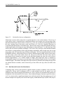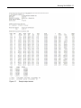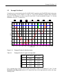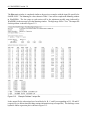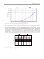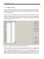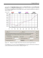
1
United States
Department
of Agriculture
WinXSPRO, A Channel Cross
Section Analyzer, User’s Manual,
Version 3.0.
Forest Service
Rocky Mountain
Research Station
General Technical
Report RMRS-GTR-147
January 2005
Thomas Hardy, Palavi Panja, and Dean Mathias
Hardy, Thomas; Palavi Panja; and Dean Mathias. 2005 WinXSPRO, A Channel Cross Section
Analyzer, User’s Manual, Version 3.0. Gen. Tech. Rep. RMRS-GTR-147. Fort Collins, CO: U.S.
Department of Agriculture, Forest Service, Rocky Mountain Research Station. 94 p.
ABSTRACT
WinXSPRO is an interactive Windows™ software package designed to analyze stream channel cross
section data for geometric, hydraulic, and sediment transport parameters. WinXSPRO was specifically
developed for use in high-gradient streams (gradient > 0.01) and supports four alternative resistance
equations for computing boundary roughness and resistance to flow. Cross section input data may be
from standard cross section surveys using a rod and level or sag-tape procedures. WinXSPRO allows
the user to subdivide the channel cross section into multiple sub-sections and has the ability to vary
water-surface slopes with discharge to reflect natural conditions. Analysis options include developing
stage-discharge relationships, evaluating changes in channel cross-sectional area, and computing
sediment transport rates. Resource specialists can use the estimated stream-channel geometry cross
section hydraulic characteristics and sediment transport output to assist with channel design and
monitoring, instream flow analysis, the restoration of riparian areas, and the placement of instream
structures.
The AUTHORS
Thomas Hardy, Associate Director of the Utah Water Research Laboratory, Utah State University,
Logan, UT 84322-8200
Palavi Panja, Research Programmer, Utah Water Research Laboratory, Utah State University, Logan,
UT 84322-8200.
Dean Mathias, Lead System Analyst, Utah Water Research Laboratory, Utah State University, Logan,
UT 84322-8200.
This is a revised electronic version of the original publication. It corrects errors discovered subsequent
to publication of the original hard-copy publication of General Technical Report RMRS-GTR-147.
ERRATA for RMRS-GTR-147
Section 4.5.2: The “Geometry Only” option has been disabled in this version of WinXSPRO.
Equivalent output tables can be found in the output under either the “Hydraulics Only” or the “Both
Hydraulics and Regression” options when run.
Citation: Should be dated 2005 instead of 2004.
WinXSPRO
A Channel Cross Section Analyzer
User’s Manual
Prepared by
Thomas Hardy
Palavi Panja
Dean Mathias
Institute for Natural Systems Engineering
Utah Water Research Laboratory
Utah State University
Modified from Earlier Versions Prepared by
Grant et al. 1992
and
WEST, Inc. 1998
Produced by
USDA Forest Service
Washington Office
Watershed, Fish, Wildlife, Air, & Rare Plants Staff
Stream Systems Technology Center
Prepared in support of the National Stream Systems Technology Center mission to enable land
managers to “secure favorable conditions of water flows” from our National Forests.
ii
ACKNOWLEDGMENTS
The development of the original version of this software, called XSPRO, Version 1.0, was supported by
the USDA Forest Service, Pacific Northwest Experiment Station, Corvallis, Oregon, and the Ecology,
Range, and Watershed Management Staff of the Northwest Region, Portland, Oregon. Further software
development, testing, and publication were supported by the Division of Resource Services and the
Technology Transfer Staff, Bureau of Land Management Service Center, Denver, Colorado. This
version was published as: Grant, Gordon E., Duval, Joseph E., Koerper, Greg J., and James L.
Fogg, 1992. XSPRO: A Channel Cross-Section Analyzer. USDI Bureau of Land Management and
USDA Forest Service, Technical Note 387, BLM/SC/PT-92/001+7200, Denver, CO.
The development of a Windows™-based program renamed WinXSPRO, Versions 2.x, was supported by
the USDA Forest Service, Rocky Mountain Research Station, Stream Systems Technology Center, Fort
Collins, Colorado. Version 2 added and improved many of the channel hydraulics features of the
program and added bed load sediment transport modeling capabilities provided by Dr. Jon Nelson,
Research Hydrologist, U.S. Geological Survey, Water Resources Division, Denver, Colorado.
Programming, document revision, and coding of the sediment transport relations were supervised by Mr.
Marty Teal, WEST Consultants, Inc., San Diego, California. This version was distributed as: USDA
Forest Service, 1998. WinXSPRO, A Channel Cross-Section Analyzer, User’s Manual. USDA
Forest Service, Rocky Mountain Research Station, Fort Collins, CO, unpublished manuscript.
Version 3 is also a Windows™-based version of WinXSPRO supported by the USDA Forest Service,
Rocky Mountain Research Station, Stream Systems Technology Center, Fort Collins, Colorado. It
contains numerous enhancements and improvements derived from user input and feedback from using
previous versions of the software. Programming and document revision was supervised by Dr. Thomas
Hardy, Utah State University, Institute for Natural Systems Engineering while programming changes
were made by Mrs. Palavi Panja and Mr. Dean Mathias.
The authors wish to thank the numerous Forest Service and other users who tested earlier versions,
identified “glitches” and provided useful suggestions for improving the program. We especially wish to
thank Dr. Gordon Grant, Dr. Jon Nelson, Jim Fogg, and Toby Hanes for critical review of the software
and documentation. Finally, we wish to thank Larry Schmidt and John Potyondy of the Stream Systems
Technology Center for their leadership and diligent work in making this Windows™ version of the
WinXSPRO program a reality.
iii
DISCLAIMER
This software is in the public domain, and the recipient may not assert any proprietary rights thereto nor
represent it to anyone as other than a Government-produced program. WinXSPRO is provided “as-is”
without warranty of any kind, including, but not limited to, the implied warranties of merchantability
and fitness for a particular purpose. The user assumes all responsibility for the accuracy and suitability
of this program for a specific application. In no event will the USDA Forest Service, WEST Consultants,
Inc., or Utah State University, be liable for any damages, including lost profits, lost savings, or other
incidental or consequential damages arising from the use of or the inability to use this program.
DOWNLOAD INFORMATION
This User’s Guide and the WinXSPRO program can be downloaded from:
http://www.stream.fs.fed.us/publications/software.html.
This publication may be updated as features and modeling capabilities are added to the program. Users
may wish to periodically check the download site for the latest updates.
WinXSPRO is supported by and limited technical support is available from USDA Forest Service,
Washington Office Watershed, Fish, Wildlife, Air, & Rare Plants Staff, Streams Systems Technology
Center, Fort Collins, CO. The preferred method of contact for obtaining support is to send an e-mail to
[email protected] requesting “WinXSPRO Support” in the subject line.
USDA Forest Service
Rocky Mountain Research Station
Stream Systems Technology Center
2150 Centre Ave., Bldg. A, Suite 368
Fort Collins, CO 80526-1891
(970) 295-5983
iv
Table of Contents
WinXSPRO...........................................................................................................................................i
Acknowledgments............................................................................................................................... ii
Disclaimer .......................................................................................................................................... iii
Download Information....................................................................................................................... iii
Table of Contents................................................................................................................................iv
List of Figures .....................................................................................................................................vi
List of Tables ......................................................................................................................................vi
Chapter 1 - Introduction.......................................................................................................................1
1.1
Purpose of WinXSPRO................................................................................................1
1.2
Applications of WinXSPRO ........................................................................................1
1.3
Overview of User's Manual .........................................................................................2
1.4
Features of WinXSPRO...............................................................................................3
1.5
Computer Requirements ..............................................................................................3
Chapter 2 - Theoretical Basis...............................................................................................................4
2.1
General.........................................................................................................................4
2.2
General Assumptions and Limitations.........................................................................5
2.3
Flow Resistance Equations ..........................................................................................5
2.4
Subdivision of Cross Sections ...................................................................................16
2.5
Gini Coefficient .........................................................................................................17
2.6
Sediment Transport....................................................................................................17
Chapter 3 - Field Procedures and Techniques ...................................................................................22
3.1
General.......................................................................................................................22
3.2
Reach Selection..........................................................................................................22
3.3
Field Procedures ........................................................................................................23
Chapter 4 - Running WinXSPRO ......................................................................................................27
4.1
Windows™..................................................................................................................27
4.2
Program Installation...................................................................................................27
4.3
Overview of Program Use .........................................................................................28
4.4
Creating a Plan...........................................................................................................28
4.5
Main Plan Window ....................................................................................................30
4.6
Cross Section Window...............................................................................................36
4.7
Stage & Section Window...........................................................................................36
4.8
Manning's n Window .................................................................................................37
4.9
Pull-down Menus .......................................................................................................38
4.10 Toolbar.......................................................................................................................50
4.11 Output Files................................................................................................................51
Chapter 5 - Example Problems ..........................................................................................................54
5.1
Example Problem 1....................................................................................................54
5.2
Example Problem 2....................................................................................................62
5.3
Example Problem 3....................................................................................................65
5.4
Example Problem 4....................................................................................................68
Chapter 6 - References.......................................................................................................................73
v
Appendix A – List of Symbols ..........................................................................................................76
Appendix B – Using WinXSPRO With Spreadsheet Programs ........................................................78
Appendix C – Glossary......................................................................................................................79
Appendix D – Error and Warning Messages .....................................................................................86
Appendix E - WinXSPRO Sample Files ...........................................................................................92
Typical Cross Sections...........................................................................................................92
Cross Section With Undercut Banks .....................................................................................92
Compare Two Cross Sections................................................................................................92
Nelson et al. Resistance Method and Bed Load Computations.............................................93
Index ..................................................................................................................................................94
vi
List of Figures
Figure 2.1. Computational elements of hydraulic parameters. ...........................................................4
Figure 2.2. Typical channel configurations that disrupt uniform flow...............................................6
Figure 3.1. Sag tape survey configuration ........................................................................................23
Figure 3.2. Rod and level survey configuration................................................................................24
Figure 3.3. Diagram of longitudinal profile and plan view of a pool-riffle sequence. .....................25
Figure 4.1. Main plan window..........................................................................................................29
Figure 4.2. Input data editor..............................................................................................................31
Figure 4.3. User defined data format dialog box ..............................................................................33
Figure 4.4. Portion of user defined sample input file .......................................................................33
Figure 4.5. Area comparison window...............................................................................................43
Figure 4.6. Plot parameters dialog box .............................................................................................48
Figure 4.7. Sample output screen......................................................................................................53
Figure 5.1. Example cross section ....................................................................................................54
Figure 5.2. Initial blank plan.............................................................................................................55
Figure 5.3 Updated WinXSPRO plan window after cross section geometry file is selected ..........55
Figure 5.4. Updated WinXSPRO plan window after setting initial analysis options.......................56
Figure 5.5. WinXSPRO cross section plot and stage and section input form ..................................57
Figure 5.6. Completed stage and section form .................................................................................58
Figure 5.7. Manning’s n input data screen for the first defined section ...........................................58
Figure 5.8. Stage and Manning’s n values for the first (left-most) section defined for the channel 59
Figure 5.9. Example Problem 1 output file.......................................................................................60
Figure 5.10. Example Problem 2 output file......................................................................................63
Figure 5.11. Example Problem 3 definition sketch ...........................................................................65
Figure 5.12. Example Problem 3 output file......................................................................................66
Figure 5.13. Discharge vs. hydraulic radius regression curve ...........................................................67
Figure 5.14. Stage-discharge regression curve ..................................................................................67
Figure 5.15. Modify Data screen using the BEFORE.SEC input file ...............................................68
Figure 5.16. Example of Compare Areas Window with values set for Example Problem 4.............69
Figure 5.17. Difference between Before and After using the Gini coefficient..................................70
Figure 5.18. Example Problem 4 hydraulic analysis output ..............................................................71
Figure 5.19. Ackers-White dialog box with data field for Example problem 4 ................................71
Figure 5.20. Ackers-White sediment rating curve .............................................................................72
Figure C-1. Example of main channel vs. left and right overbank roughness areas. .......................85
List of Tables
Table 2.1. Base values of Manning's n ............................................................................................8
Table 2.2. Factors that affect roughness of the channel ...................................................................9
Table 5.1. Example Problem 3 region and stage data.....................................................................65
Table C-1 Sediment size classes .....................................................................................................85
Introduction 1
Chapter 1 - Introduction
1.1
Purpose of WinXSPRO
WinXSPRO is an interactive, Windows™ software package designed to assist watershed specialists in
analyzing stream channel cross section data for geometric, hydraulic and sediment transport parameters.
Although the program can be used with streams of any gradient, it has been specifically developed to
handle channel geometry and hydraulic conditions for single transects in steep (gradient > 0.01) streams.
Several resistance equations are supported, including those specifically designed for large roughness
channels. Analysis options include developing stage-to-discharge relationships, calculating depth
required to inundate valley floor surfaces, evaluating changes in channel cross-sectional area, and
computing sediment transport rates. Both graphical and tabular output can be generated. WinXSPRO
can assist resource specialists in analyzing instream flow needs, performing hydraulic reconstructions,
designing effective channel and riparian structures, and monitoring channel changes.
1.2
Applications of WinXSPRO
Information on stream-channel geometry, hydraulic characteristics, and sediment transport rates is useful
for channel design, restoration of riparian areas, and placement of instream structures. The analyses of
cross section hydraulics, along with an evaluation of flood frequency, are primary considerations in
channel design. Once a desired bank-full flow is defined, the channel is designed to contain that flow,
and higher flows are allowed to spread over the floodplain. Such periodic flooding is extremely
important for the formation of channel macro-features (e.g., point bars and meander bends) and for
establishment of certain kinds of riparian vegetation. A cross section analysis may also help in optimal
placement of such items as culverts and fish habitat structures.
Additionally, knowledge of the relationships between discharge, channel geometry and hydraulics is
useful for reconstructing the conditions associated with a particular flow situation. For example, in
many channel stability analyses, it is customary to relate movement of streambed materials to some
measure of stream power or average bed shear stress. If the relations between streamflow and certain
hydraulic variables (e.g., mean depth and water-surface slope) are known, it is possible to estimate
stream power and average bed shear at any given level of flow. Thus, a channel cross section analysis
makes it possible to estimate conditions of streambed particle movement at various levels of streamflow.
WinXSPRO also includes two sediment transport relations: the Parker model for gravel-bed rivers and
the Ackers-White model for sand-bed channels.
Finally, cross section analyses provide important information for instream flow assessments. Various
riparian resource values may be altered by changes in hydraulic parameters associated with changes in
streamflow. For example, the relation between low-water discharge and channel wetted perimeter may
be an important consideration for macroinvertebrate production or the scenic enjoyment of a stream.
Similarly, cross section data may be used to define the depth-discharge relationship for analysis of fish
habitat. Also, if the recurrence frequencies of various discharges are known, a depth-duration
relationship may be constructed. The applications of WinXSPRO are not limited by those described
here; with some imagination, the user will find others for which the tools in the program will serve.
2 WinXSPRO Version 3.0
1.3
Overview of User's Manual
This manual describes the fundamental concepts, methodologies, capabilities and limitations, features,
input requirements, and output of WinXSPRO. The manual is organized into the following sections:
Introduction (Chapter 1)
This chapter.
Theoretical Basis (Chapter 2)
Chapter 2 describes the theoretical basis for the hydraulic, flow resistance, and sediment
transport calculations used in WinXSPRO.
Field Procedures and Techniques (Chapter 3)
Chapter 3 provides guidance on selection of reaches and representative cross sections where
information is to be collected and field procedures to be used in the collection.
Running WinXSPRO (Chapter 4)
Chapter 4 covers information on installing the program, setting up projects and plans, and
navigating through the program itself. Input and output data and all options available within
WinXSPRO are described in this chapter.
Example Problems (Chapter 5)
Chapter 5 provides example applications of WinXSPRO.
References (Chapter 6)
Chapter 6 is a listing of references cited.
Appendices
Appendix A is a list of symbols that are used in this manual and Appendix B addresses use of
WinXSPRO with spreadsheet programs. Appendix C is a glossary of terms and phrases used in
this manual, and Appendix D lists and explains the warning and error messages used in
WinXSPRO. Appendix E explains typical sample files distributed with the software.
Introduction 3
1.4
Features of WinXSPRO
The WinXSPRO program is designed for analyzing channel cross section data in an interactive, userfriendly environment. The program is run under Microsoft® Windows™ with easy-to-read input and
output screens and many other features common to Windows™ programs. WinXSPRO uses a
resistance-equation approach (e.g., Manning's equation) to single cross section hydraulic analysis, and is
capable of analyzing the geometry, hydraulics and sediment transport potential of a given channel cross
section (including sections with undercut banks). WinXSPRO was specifically developed for use in
high-gradient streams and supports four alternative resistance equations for computing boundary
roughness and resistance to flow. The program allows the user to subdivide the channel cross section so
that overbank areas, mid-channel islands, and high-water overflow channels may be analyzed separately.
WinXSPRO also allows input of water-surface slopes such that the slope will vary with discharge to
reflect natural conditions. The user can overlay plots and compute the difference in area between two
cross sections using a special feature of the program. Sediment transport calculations can be performed
using one bed load equation and one total load equation.
1.5
Computer Requirements
WinXSPRO requires Microsoft® Windows™ Version 3.1 or higher, a minimum of 4 MB hard disk
space and 4 MB RAM. Eight (8) MB RAM is recommended for faster operation. Installation of the
program is described in Chapter 4.
4 WinXSPRO Version 3.0
Chapter 2 - Theoretical Basis
2.1
General
The theoretical background for analyzing channel cross section data is derived from the basic continuity,
momentum, and energy equations of fluid mechanics. Specifically, streamflow at a cross section is
computed using the simplified form of the continuity equation where discharge equals the product of
velocity and cross-sectional area of flow. Computation of cross-sectional area is strictly a geometry
problem; it is determined by inputting incremental depths of water (stage) to a channel cross section
defined by distance-elevation pairs. In addition to cross-sectional area, the top width, wetted perimeter,
mean depth, and hydraulic radius are computed for each increment of stage (Figure 2.1).
Figure 2.1.
Computational elements of hydraulic properties.
Once the channel geometry has been computed for a given stage, an estimate of mean cross section
velocity is needed to produce an estimate of streamflow. Analysis of the momentum and energy
equations requires that, under certain streamflow conditions, gravitational forces that cause water to
move downhill are balanced by frictional forces at the channel boundary that tend to resist the downhill
flow. Under these conditions it is possible to estimate resistance to flow and, hence, mean velocity at
the channel cross section. Thus, various resistance equations have been developed for estimating mean
velocity as a function of cross section hydraulic parameters.
Sediment transport relations have also been developed based on hydraulic parameters, most notably
shear stress and velocity. For steep streams, sediment transport is mostly as bed load, i.e., by particles
rolling or sliding along the streambed, or moving by short jumps (saltating). For streams with smaller
gradients, transport generally will occur as both bed load and suspended load (where some particles are
supported above the bed by turbulence and transported at about the local flow velocity).
Theoretical Basis 5
2.2
General Assumptions and Limitations
As indicated, the mean velocity of streamflow in a cross section can be computed when certain flow
conditions are met. The main criteria for these flow conditions is that the bed slope, the water-surface
slope, and the total energy grade line are essentially parallel. The total energy of the stream is a function
of the position of the streambed above some arbitrary datum (potential energy), the depth of the water
column (pressure energy), and the velocity of the water column (kinetic energy). The slope of the total
energy grade line indicates the rate at which energy is dissipated through turbulence and boundary
friction. When the slope of this line is known, the various resistance formulas allow computation of
mean cross-sectional velocity. When the water-surface and the energy grade line parallel the streambed,
the energy grade line slope is assumed to be the same as the water-surface slope.
Under conditions of constant width, depth, area, and velocity, the water surface slope and energy grade
line approach the slope of the streambed, producing a condition known as "uniform flow." One feature
of uniform flow is that the streamlines (the traces of the path that a particle of water would follow in the
flow) are parallel and straight (Roberson and Crowe 1985). Perfectly uniform flow rarely occurs in
natural channels, but the condition is approached in some reaches where the geometry of the channel
cross section is relatively constant throughout the reach. Conditions that tend to disrupt uniform flow
include bends in the stream course; changes in cross section geometry; obstructions to flow caused by
large roughness elements such as channel bars, large boulders, and woody debris; or other features that
cause convergence, divergence, acceleration, or deceleration of flow (Figure 2.2). Resistance equations
also may be used to evaluate these non-uniform flow conditions (gradually varied flow); however,
energy-transition calculations (backwater) must then be included in the analysis. This requires the use
of multiple transect numerical models (e.g., HEC-2, HEC-RAS, WSPRO).
2.3
Flow Resistance Equations
WinXSPRO supports four sets of resistance equations for estimating mean velocity at a cross section.
Each equation or set of equations was developed from specific sets of data; therefore, use of a particular
resistance formula to estimate velocity is subject to the limitations of the data used to develop that
formula, as well as the assumptions of the formula itself. Also, because each resistance equation
estimates channel resistance or roughness in a slightly different way, the different formulas may require
different inputs from the user and will likely produce somewhat different results. Selection of the
appropriate resistance equation requires understanding the assumptions and limitations of each
approach.
6 WinXSPRO Version 3.0
Figure 2.2.
2.3.1
Typical channel configurations that disrupt uniform flow.
Manning's Equation
WinXSPRO supports the use of Manning's equation for estimating mean cross section velocity.
Manning's equation was developed for conditions of uniform flow (described previously). Lacking a
better solution, it is assumed that the equation is also valid for non-uniform reaches that are invariably
encountered in natural channels if the energy gradient is modified to reflect only the losses due to
boundary friction (Dalrymple and Benson 1967). The Manning equation for mean velocity is given as:
V =
where:
V
k
n
R
S
=
=
=
=
=
k 2 / 3 1/ 2
R S
n
average velocity in the cross section (ft/s or m/s)
1.0 for metric units and 1.486 for English units,
Manning's roughness coefficient,
hydraulic radius (ft or meters) , and
energy slope (ft/ft or m/m) (water-surface slope for uniform flow).
(1)
Theoretical Basis 7
In Manning's equation, resistance to flow due to friction at the channel boundary is addressed through
the use of a roughness coefficient, n, supplied by the user of the equation. The roughness coefficient
may be thought of as an index of the features of channel roughness that contribute to the dissipation of
stream energy.
There are three methods for estimating Manning's roughness coefficient for natural channels: direct
solution of Manning's equation for n (given R, S, and V in the above equation), comparison with
computed n values for other channels, and formulas relating n to other hydraulic parameters. Each
method has its own limitations and advantages.
The method of direct solution entails measuring stream discharge and dividing by the cross sectional
flow area to obtain a mean velocity. The mean velocity, hydraulic radius (roughly equal to mean depth
for wide channels), and water-surface slope are entered into Manning's equation, and the equation is
solved directly for the roughness coefficient, n. This approach gives an estimate of n that is as accurate
as the associated measurement of discharge, cross sectional area, and water-surface slope. However, the
n value obtained is only applicable to the particular stage and cross sectional geometry at which the flow
was measured. Even at a given stage the n value can vary seasonally due to vegetation and temperature
effects.
Since the features of channel roughness that contribute to energy dissipation will vary with water level,
n also will vary with water level; therefore, it is desirable to directly estimate n at more than one level of
streamflow. Most authors cited have found that n values decrease with increasing stage, at least up to
bank-full flow. If streamflow can be measured at several different stages, n may be calculated for a
range of flows and the relationship between n and stage determined.
The second method for estimating n values at a cross section involves comparing the reach to a similar,
measured reach for which Manning's n has already been computed. This is probably the quickest and
most commonly used procedure for estimating Manning's n and is usually done from either a table of
values or by comparison with photographs of natural channels. Tables of Manning's n values for a
variety of natural and artificial channels are common in the literature on hydraulics (e.g., Chow 1959;
Van Haveren 1986). Photographs of stream reaches with computed n values have been compiled by
Chow (1959) and Barnes (1967); Arcement and Schneider (1984) extended this work for floodplain
areas.
When the roughness coefficient is estimated from table values or by comparison with photographs of
natural channels with known n, the chosen n value is considered a base value, nb, that may need to be
adjusted for local channel conditions. Several publications provide procedures for adjusting nb to
account for channel irregularities, vegetation, obstructions, and sinuosity (Chow 1959; Benson and
Dalrymple 1967; Arcement and Schneider 1984; Parsons and Hudson 1985). The most common
procedure uses the formula proposed by Cowan (1956) to estimate the value of n:
n = (nb + n1 + n2 + n3 + n4)m
(2)
8 WinXSPRO Version 3.0
where:
nb
=
n1
n2
n3
n4
m
=
=
=
=
=
base value of n for a straight, uniform, smooth channel in natural
materials,
correction for the effect of surface irregularities,
correction for variations in cross section size and shape,
correction for obstructions,
correction for vegetation and flow conditions, and
correction for degree of channel meandering.
Table 2.1 is taken from Aldridge and Garrett (1973) and may be used to estimate the base n values for
stable channels and floodplains, where stable channels are defined as those where the bed is composed
of firm soil, gravel, cobbles, boulders, or bedrock and which remains relatively unchanged through most
of the range of flows. The base values of Benson and Dalrymple (1967) generally apply to conditions
that are close to average whereas Chow's (1959) base values are for the smoothest reach attainable for a
given bed material. Table 2.2 is also taken from Aldridge and Garrett (1973) and may be used to
estimate each of the correction factors in Equation 2 to produce a final estimated n.
Table 2.1.
Base values of Manning's n [modified from Aldridge and Garrett (1973) Table 1].
Channel or
floodplain type
Millimeters
Inches
Benson and
Dalrymple (1967)1
Chow (1959)2
-
-
0.012-0.018
0.011
Rock cut
-
-
-
0.025
Firm soil
-
-
0.025-0.032
0.020
Coarse sand
1-2
-
0.026-0.035
-
Fine gravel
-
-
-
0.024
2-64
0.08-2.5
0.028-0.035
-
-
-
-
0.026
Cobble
64-256
2.5-10.1
0.030-0.050
-
Boulder
>256
>10.1
0.040-0.070
-
Coarse gravel
Straight uniform channel.
Smoothest channel attainable for indicated material.
2
Base n value (nb)
Concrete
Gravel
1
Median size of bed material
Theoretical Basis 9
Table 2.2.
Factors that affect roughness of the channel (modified from Aldridge and Garrett
(1973), Table 2).
Degree of
irregularity (n1)
Variation in
channel cross
section (n2)
1
Channel
conditions
n value
adjustment1
Example
Smooth
0.000
Compares to the smoothest channel attainable
in a given bed material.
Minor
0.001-0.005
Compares to carefully dredged channels in
good condition but having slightly eroded or
scoured side slopes.
Moderate
0.006-0.010
Compares to dredged channels having
moderate to considerable bed roughness and
moderately sloughed or eroded side slopes.
Severe
0.011-0.020
Badly sloughed or scalloped banks of natural
streams; badly eroded or sloughed sides of
canals or drainage channels; unshaped, jagged,
and irregular surfaces of channels in rock.
Gradual
0.000
Size and shape of channel cross sections
change gradually.
Alternating
occasionally
0.001-0.005
Large and small cross sections alternate
occasionally, or the main flow occasionally
shifts from side to side owing to changes in
cross sectional shape.
Alternating
frequently
0.010-0.015
Large and small cross sections alternate
frequently, or the main flow frequently shifts
from side to side owing to changes in cross
sectional shape.
Adjustments for degree of irregularity, variations in cross section, effect of obstructions, and vegetation are added
to the base Manning's n value before multiplying by the adjustment for meander, m.
10 WinXSPRO Version 3.0
Table 2.2.
Factors that affect roughness of the channel – (continued).
Effect of
obstruction (n3)
Amount of
vegetation (n4)
1
Channel
conditions
n value
adjustment1
Example
Negligible
0.000-0.004
A few scattered obstructions, which include
debris deposits, stumps, exposed roots, logs,
piers, or isolated boulders, that occupy less
than 5 percent of the cross sectional area.
Minor
0.005-0.015
Obstructions occupy less than 15 percent of
the cross sectional area and the spacing
between obstructions is such that the sphere of
influence around one obstruction does not
extend to the sphere of influence around
another obstruction. Smaller adjustments are
used for curved smooth-surfaced objects than
are used for sharp-edged angular objects.
Appreciable
0.020-0.030
Obstructions occupy from 15 to 20 percent of
the cross sectional area or the space between
obstructions is small enough to cause the
effects of several obstructions to be additive,
thereby blocking an equivalent part of a cross
section.
Severe
0.040-0.050
Obstructions occupy more than 50 percent of
the cross sectional area or the space between
obstructions is small enough to cause
turbulence across most of the cross section.
Small
0.002-0.010
Dense growths of flexible turf grass, such as
Bermuda, or weeds growing where the average
depth of flow is at least two times the height of
the vegetation; supple tree seedlings such as
willow, cottonwood, arrowweed, or saltcedar
growing where the average depth of flow is at
least three times the height of the vegetation.
Adjustments for degree of irregularity, variations in cross section, effect of obstructions, and vegetation are added
to the base Manning's n value before multiplying by the adjustment for meander.
Theoretical Basis 11
Table 2.2.
Factors that affect roughness of the channel – (continued).
Amount of
vegetation (n4) continued
1
Channel
conditions
n value
adjustment1
Example
Medium
0.010-0.025
Turf grass growing where the average depth of
flow is from one to two times the height of the
vegetation; moderately dense stemmy grass,
weeds, or tree seedlings growing where the
average depth of flow is from two to three times
the height of the vegetation; brushy, moderately
dense vegetation, similar to 1- to 2-year-old
willow trees in the dormant season, growing
along the banks and no significant vegetation
along the channel bottoms where the hydraulic
radius exceeds 2 feet.
Large
0.025-0.050
Turf grass growing where the average depth of
flow is about equal to the height of vegetation;
8- to 10-year-old willow or cottonwood trees
intergrown with some weeds and brush (none of
the vegetation in foliage) where the hydraulic
radius exceeds 2 feet; bushy willows about 1
year old intergrown with some weeds along side
slopes (all vegetation in full foliage) and no
significant vegetation along channel bottoms
where the hydraulic radius is greater than 2 feet.
Very Large
0.050-0.100
Turf grass growing where the average depth of
flow is less than half the height of vegetation;
bushy willow trees about 1 year old intergrown
with weeds along the side slopes (all vegetation
in full foliage) or dense cattails growing along
channel bottom; trees intergrown with weeds
and brush (all vegetation in full foliage).
Adjustments for degree of irregularity, variations in cross section, effect of obstructions, and vegetation are added
to the base Manning's n value before multiplying by the adjustment for meander.
12 WinXSPRO Version 3.0
Table 2.2.
Factors that affect roughness of the channel – (continued).
Degree of
meandering1
(adjustment
values apply to
flow confined in
the channel and
do not apply
where
downvalley flow
crosses
meanders)
Channel
conditions
Meander
adjustment, m1
Example
Minor
1.00
Ratio of the channel length to valley
length is 1.0 to 1.2.
Appreciable
1.15
Ratio of the channel length to valley
length is 1.2 to 1.5.
Severe
1.30
Ratio of the channel length to valley
length is greater than 1.5.
1
Adjustments for degree of irregularity, variations in cross section, effect of obstructions, and vegetation are added
to the base n value before multiplying by the adjustment for meander.
While estimating Manning's roughness coefficient from a table of values or by comparison with
photographs of channels with known n is the quickest and most commonly used method, most
experienced hydrologists and river engineers simply estimate n from experience -- often the tables and
photographs are not even consulted. For that reason, this method is subject to the most variability
between individuals and is probably the least consistent method for arriving at Manning's n. Also, the
method ordinarily is used to produce a single value for roughness, which is then applied throughout the
entire range of flow, often introducing large errors for the estimate at high or low flows.
The third method of determining Manning's roughness coefficient for a cross section uses empirical
formulas relating n to other hydraulic parameters. Many of these formulas assume that a representative
particle size in the channel boundary dominates the hydraulic roughness; hence, the empirical
relationships usually correlate n with some statistical index of bed material size distribution. As such,
these formulas do not adjust n for changes in depth of flow at the cross section. To compensate for
changes in roughness with depth of flow, several formulas have been developed that use a relative
roughness term relating some representative particle size (e.g., the 84th-percentile particle size) to the
hydraulic radius or mean depth. Changes in depth of flow therefore change roughness and n values.
Some empirical formulas, such as the Jarrett (1984) formula described later, do not use particle size but
relate the roughness coefficient n to other hydraulic parameters, such as slope and hydraulic radius.
Just as Manning's n may vary significantly with changes in stage (water level), channel irregularities,
obstructions, vegetation, sinuosity, and bed material size distribution, n may also vary with bed forms in
the channel. The hydraulics of sand and mobile-bed channels produce changes in bed forms as the
velocity, stream power, and Froude number increase with discharge (note, however, that bed forms
rarely occur in sediments coarser than approximately 0.6 mm [ASCE, 1966]). As velocity and stream
power increase, bed forms evolve from a plane bed to ripples, to dunes, to washed-out dunes, to plane
Theoretical Basis 13
bed again, to antidunes, and to chutes and pools. Ripples and dunes occur when the Froude number is
less than 1 (subcritical flow); washed out dunes occur at a Froude number near 1 (critical flow); and
plane bed, antidunes, and chutes and pools occur at a Froude number greater than 1 (supercritical flow).
Manning's n attains maximum values when dune or anti-dune bed forms are present, and minimum
values when ripples and plane bed forms are present (Parsons and Hudson 1985).
Vegetation can cause Manning's n to change, sometimes drastically, between seasons. The effect of
vegetation depends mainly on height, density, distribution, and type of vegetation, as well as the flow
conditions. The depth of flow is important because as the water level in a stream rises, different types,
distributions, stiffness, and densities of vegetation may be encountered. Also, under flows of sufficient
depth, many types of vegetation such as grasses and weeds will bend over to produce lower n values.
The slope of the channel can amplify this effect because a steep slope causes greater velocity, which
leads to greater flattening of vegetation.
Because Manning's roughness coefficient varies with different flows and cross section characteristics, it
is important to define the variability of n over the entire range of flows when conducting cross section
analyses. If possible, this is best accomplished by measuring discharge at several different water levels
(stages), solving Manning's equation for the true value of n at each stage, and developing a relation
between stage and Manning's n. If Manning's n is estimated from a table of values or by comparison
with photographs, estimates should be made for several stages, and the relationship between n and stage
defined for the flow range of interest. If empirical formulas are used to estimate n, it is best to select a
formula that is sensitive to mean depth or hydraulic radius, such as the formulas that use a relative
roughness term. It is wise to perform a sensitivity analysis to show the effect of changes in n values on
hydraulic parameters such as discharge and velocity, especially if bed forms or vegetative characteristics
vary over the range of discharges.
2.3.2
Thorne and Zevenbergen's Recommended Equations
Resistance equations that include a term for relative roughness (the ratio of the bed material size to the
flow depth or hydraulic radius) have an inherent sensitivity to changes in depth for low to moderate flow
depths. Thorne and Zevenbergen (1985), in a review of resistance equations developed for mountain
streams, tested several formulas using relative submergence terms for estimating mean velocity in steep,
cobble/boulder-bed channels (note that any consistent set of units may be used with these equations).
For small relative roughness values (relative submergence, R/d84, greater than 1), Thorne and
Zevenbergen recommended an equation developed by Hey (1979) for estimating mean cross section
velocity:
V
= 5.62 log
( gRS )1 / 2
( )
a′R
3.5 d84
(3)
14 WinXSPRO Version 3.0
( )
a ′ = 11.1
R −0.314
Dmax
(4)
where:
V
g
d84
Dmax
=
=
=
=
mean cross section velocity (ft/s),
acceleration due to gravity (ft/s2),
intermediate axis for the 84th-percentile particle size (ft), and
maximum depth of section (ft).
Similarly, for large relative roughness values (relative submergence, R/d84, less than or equal to 1),
Thorne and Zevenbergen recommended Bathurst's (1978) equation for estimating mean cross section
velocity:
⎛
⎞
V
R
⎟⎟
= ⎜⎜
1/ 2
( gRS )
⎝ 0.365d84 ⎠
2.34
⎛W ⎞
⎜ ⎟
⎝D⎠
7 ( λE −0.08 )
(5)
⎛ R ⎞
⎟⎟
⎝ d 84 ⎠
λE = 0.039 − 0.139 log⎜⎜
(6)
where:
D
W
=
=
mean flow depth (ft or m), and
water surface width (ft or m).
WinXSPRO supports these formulas as an option for calculating mean cross section velocity. However,
in applying these formulas to a cross section analysis, the assumptions of the equations must be
considered, i.e., that channel gradients generally exceed 1 percent, channel beds are predominately
cobble and boulder substrate, and relative roughness is large. Thorne and Zevenbergen (1985) reported
average errors of only 6 percent when using the Hey equation for small values of relative roughness
(relative submergence R/d84>>1), but even the best equations over predicted mean velocity by as much
as 30 percent for the highest values of relative roughness (relative submergence R/d84<1), an error they
attributed to difficulties in measuring bed material sizes. An additional factor to consider is that
WinXSPRO approximates the mean flow depth with the hydraulic depth (area/top width). In cross
sections lacking a single, well-defined channel, erroneous values may result.
2.3.3
Jarrett's Equation for Manning's Roughness Coefficient
The previous discussion of Manning's equation alluded to the existence of empirical formulas for n that
do not make use of particle-size data as an index of relative roughness. These formulas tend to relate the
roughness coefficient to other hydraulic parameters. Jarrett (1984) developed the following equation for
n, relating the roughness coefficient to water-surface slope and hydraulic radius at the section:
n = 0.39 S0.38 R-0.16
(7)
Theoretical Basis 15
where R is in feet. Jarrett's equation for n has no explicit term for relative roughness; however, he
reported a positive correlation between water-surface slope and coarse bed material particle size. Thus,
although particle size is not an explicit part of the equation, it is still implicit in the slope term. Jarrett
also reported a slightly stronger correlation between Manning's n and slope than the correlation between
n and d84 particle size.
Jarrett (1984) also compared n values calculated with the above equation to actual n values obtained
from cross sections with measured hydraulic geometry and flow data. The average standard error of the
estimated n values was 28 percent, and ranged from -24 percent to +32 percent. Jarrett found the
equation to slightly overestimate n, with the greatest errors typically associated with low-flow
measurements when the ratio of R/d50 is less than 7.
WinXSPRO supports the use of Jarrett's equation for estimating Manning's roughness coefficient and
mean cross section velocity. Again, the limitations of the data from which the equation was developed
should be considered when performing a cross section analysis. Specifically, the equation is limited to
the following conditions:
1.
2.
3.
4.
5.
Natural channels having stable bed and bank materials (gravels, cobbles, and boulders),
Water-surface slopes between 0.2 and 4.0 percent,
Hydraulic radii from 0.5 to 7.0 feet (0.15 to 2.1 meters),
Cross sections unaffected by downstream obstructions (i.e., no backwater), and
Streams having relatively small amounts of suspended sediment.
Because Jarrett's equation includes hydraulic radius as a parameter for estimating Manning's n, it is
sensitive to changes in depth. The negative exponent associated with the hydraulic-radius term indicates
diminishing resistance with increasing depth. However, the relatively low value of this exponent (n is
only sensitive to the 0.16 power of hydraulic radius) means that n will change only slightly through the
normal range of stage at a section. An independent evaluation of the equation on Idaho mountain
streams confirmed this (Potyondy 1990). Jarrett's n appeared to fit the measured data best at flows at or
above bank-full stage; the poorest fits occurred at low flow. Potyondy concluded that the equation was
best applied to bank-full flow estimates, with low-water n values supplied from field measurements of
hydraulic geometry and discharge.
2.3.4
Nelson et al. Method
This method is primarily intended for use in steep, mountainous channels that have large bed material
(i.e., large particle sizes) relative to the flow depth (typically gravel, cobble, and boulder channels). The
vertical flow structure and the relation between bottom stress and velocity are not well predicted by
existing resistance equations in these channels with high relative roughness. The Nelson et al. approach
uses measured sediment size data in conjunction with a simple model for the extraction of momentum
associated with flow around and over the large sediment particles on the bed to determine the stagedischarge relation for a given channel geometry. The method assumes that by far the majority of the
drag on the flow is produced by flow over bed particles, that is, drag due to features other than bed
particles is negligible. The Nelson et al. method is best used in channels with beds composed of
sediment sizes that are a significant fraction of the flow depth, that is, the size of the largest particles
should be at least 5% of the flow depth.
16 WinXSPRO Version 3.0
Determining a stage-discharge with the Nelson et al. method requires information about the bed particle
size distribution. Because the relative protrusion of the particles into the flow varies significantly with
flow depth, the computed vertical velocity structure also varies with flow depth. As the flow becomes
very deep, the vertical structure over most of the depth asymptotically approaches a quasi-logarithmic
profile. At shallower depths, the velocity profile varies in a relatively complicated manner as a function
of the grain geometry of the bed. Due to this complexity, approaches using constant friction or Manning
coefficients frequently fail to yield valid predictions of the stage-discharge relation. Using the
computational procedures described in Nelson et al. (1991), the spatial variation in velocity profile is
computed and a relation between the velocity profile and the depth is found using bed particle size data
that is relatively easy to measure. The computations provide a link between the discharge and boundary
shear stress distribution of the channel bed that is used along with the stream geometry to obtain a stagedischarge relation. To compute the discharge for a given stage, the computed velocity profiles for
various depths are integrated vertically and across the channel using the surveyed cross section.
Complete details about the theoretical basis and the equations used in the computations can be found in
Nelson et al. (1991).
2.4
Subdivision of Cross Sections
Natural channel cross sections are rarely perfectly uniform, and it may be necessary to analyze
hydraulics in a very irregularly shaped cross section. Frequently, high-gradient streams have overflow
channels on one or both sides that carry water only during unusual high-flow events. Even in channels
of fairly regular cross section, overbank areas convey water at discharges above bank-full. These areas
usually have hydraulic properties significantly different from those of the main channel. Generally,
overflow channels and overbank areas are treated as separate subchannels.
When subdividing a channel cross section into main channel, side channels, and overbank areas,
WinXSPRO assumes frictionless vertical divisions ("smooth glass walls") between individual
subsections. The assumption of negligible shear between subsections avoids the formidable task of
estimating small energy losses due to friction and momentum exchange between adjacent moving bodies
of water. WinXSPRO also assumes that flow can access each subsection as the stage reaches the lowest
elevation of that subsection; i.e., the overflow channel or overbank area is not blocked off from the flow
at some upstream location such as in a leveed channel. If the user desires to exclude these areas from
consideration, the geometric data for those areas should be removed for the range of flows where the
channel banks are not overtopped. A cross section can be subdivided into a maximum of five
subsections (see section 4.7.2 for additional description of subsections). For any given stage, the energy
slope is assumed to be the same for each subsection, and the discharge is computed separately for each
of these subsections. The discharges from each subsection are added for the total section discharge.
Theoretical Basis 17
2.5
Gini Coefficient
The Gini coefficient (G) describes the distribution of channel depth measurements, and thus the channel
cross sectional shape. This coefficient was adapted from economics and plant population biology and its
application to stream channels was presented by Olson-Rutz and Marlow (1992). The Gini coefficient
(G) is the arithmetic average of the differences between all pairs of depths (Yi - Yj):
n
n
∑ ∑ Yi − Y j
i =1 j =1
G=
2n 2Yavg
(8)
where n is the number measured depths and Yavg is the average depth. It equals a minimum value of 0
when all depths are equal. A wide flat channel has a low G value. In contrast, a deep and narrow
channel has a greater distribution of depths and the Gini coefficient approaches its maximum value of 1.
The change in the Gini coefficient for a cross section over time describes the change in channel shape.
An increase in the Gini coefficient indicates the channel is becoming deeper and narrower. Conversely,
a decrease indicates the channel is becoming flatter and wider.
Changes in cross section shape can affect hydraulic and geomorphic processes, which, in turn, can
influence stream biota. Change-in-area indices do not always describe channel form. Observational
assessments of stream form to estimate roughness coefficients or to determine habitat suitability are
stage dependent, as are measurements of width/depth (w/d) to estimate water discharge. In contrast,
permanent measurements of channel cross sections are not influenced by water level. Water level can be
noted, however, during critical times to allow for evaluation of underwater channel shape or usable fish
habitat. A w/d value from permanent transects gives a relative indication of channel shape. However,
because the width is fixed, this ratio can be misleading. The Gini coefficient is another repeatable index
that quantifies stream channel form independent of stage height and cross sectional area. The direction
and magnitude of change in G over time describes whether a channel is becoming wider and flatter or
narrower and deeper in response to management or natural events. Because many fish species prefer
cool, slow, deep channels, early detection of changes in channel form may be important to fisheries
management. Note that because channel width increases faster than depth in downstream progression,
all index comparisons should be made over time at the same location or between streams of equal order
or drainage area.
2.6
Sediment Transport
WinXSPRO supports one bed load transport function appropriate for gravel-bed steams and one bed
material load transport function appropriate for sand-bed streams. The bed load function is that of Parker
(1990). The Parker (1990) relation estimates the quantity of material rolling, sliding or jumping
(saltating) along the bed through the given cross section. The bed material load function, that of Ackers
and White (1973), calculates the total bed material load being transported through the cross section (i.e.,
18 WinXSPRO Version 3.0
bed load plus suspended bed material load). These methods are described in more detail below. All the
sediment transport calculations in WinXSPRO use a single representative grain size to compute
sediment load.
2.6.1
Parker 1990 Function
The original Parker equation (1982) was developed using field data collected from Oak Creek, Oregon,
and several other gravel bed rivers. It allows computation of the sediment flux in a gravel-bed channel
using mean grain size by applying a similarity argument for the fluxes in various grain size classes.
Parker (1982) estimates the total bed load flux over a poorly sorted gravel bed by:
⎡⎛ ρ − ρ ⎞ 3 ⎤
⎟⎟ gd ⎥
q B = q ⎢⎜⎜ s
ρ
⎝
⎠
⎣
⎦
1/ 2
∗
B
( )
(10)
τo
( ρ s − ρ ) gd
(11)
q B∗ = W ∗ τ ∗
τ* =
(9)
3/ 2
where qB is the bed load flux per unit width, ρ and ρs are water and sediment density, respectively, and d
is the mean grain size of the surface layer.
⎧ 0.0025 exp[14.2(Φ 50 − 1) − 9.28(Φ 50 < 1) 2 ]
4.5
⎪
W* = ⎨
⎛ 0.822 ⎞
⎪11.2⎜⎜1 − Φ ⎟⎟
50 ⎠
⎝
⎩
0.95 < Φ 50 < 1.65
Φ 50 > 1.65
(12)
In equation (12), Φ50 is defined in terms of the boundary shear stress and the critical shear stress. Using
the non-dimensionalization defined in equation (9), Φ50 is given by
Φ 50 =
τ*
1.18τ c*
(13)
The value of τc* was set using the model for critical shear stress developed by Wiberg and Smith
(1987b) with a pocket angle of 30°. This yields the critical stress for first motion rather than significant
motion (see Wiberg and Smith [1987b] for a more detailed discussion), as required for use in the Parker
equation if surface particle sizes are used. The Wiberg-Smith model yields a value of about 0.028 for
τc*, in good agreement with the value of 0.0299 reported by Parker et al. (1982). In WinXSPRO, the
lower limit of Φ50 in equation (24) is 0.8 in place of 0.95 in keeping with the adaptation of Nelson
(1993).
Theoretical Basis 19
The volumetric bed load fluxes per unit width calculated from the Parker equation are multiplied by
sediment density and integrated across the channel width for each discharge using the surveyed channel
cross section. This yields the total mass of bed load discharge as a function of flow discharge.
Parker (1990) resulted from modifications to the 1982 formulation, mostly to improve matching of W*
and its derivative at the divisions between the ranges of Φ values. Also, the 1982 function was
formulated using the particle size(s) of the substrate, whereas the 1990 function uses the particle size(s)
of the surface layer. The reformulated definition is:
⎧0.00218 exp[14.2(Φ 50 − 1) − 9.28(Φ 50 − 1) 2 ]
4.5
⎪
⎛ 0.853 ⎞
⎪
*
⎟⎟
W = ⎨ 11.93⎜⎜1 −
Φ
50 ⎠
⎝
⎪
.2
⎪⎩ 0.00218Φ14
50
1 < Φ 50 < 1.59
Φ 50 > 1.59
(14)
Φ 50 < 1
All variables are defined and the bed load discharge is calculated in the same manner as described
above. WinXSPRO performs bed load calculations using a single representative grain size (D50).
For situations where the total volume of sediment moved is all that is needed, Parker 1990 with the d50
size is sufficient provided the grain size distribution is typical of gravel channels. If the grain size
distribution is poorly sorted or bimodal, it is probably better to use a different formulation of the Parker
function that permits computation by individual size fractions.
2.6.2 Ackers and White (1973) Function
This relation differs from the bed load function in that it is designed to calculate the total sediment load,
i.e., the bed load and suspended bed material sediment load combined. The equations presented here are
intended for the computation of sand transport in sand-bedded streams with bed material ranging from
0.04 to 2.5 mm. Calibration of the relation was accomplished using 925 sets of data from 14
investigators. Ackers and White developed a general sediment transport function that determines the
rate of transport in terms of three dimensionless parameters: size, mobility, and transport. The relations
are:
Ggr = f(Fgr,Dgr)
where:
Ggr
Fgr
Dgr
=
=
=
dimensionless sediment transport rate
sediment mobility number
dimensionless sediment size.
(15)
20 WinXSPRO Version 3.0
The sediment mobility, Fgr, is described by:
Fgr =
⎡
⎤
⎢
⎥
⎢
⎥
u*n
V
⎢
⎥
gd 50 ( s − 1) ⎢
⎛ D ⎞⎥
⎟⎟
32 log⎜⎜α
⎢
⎥
d
50
⎝
⎠⎦
⎣
1− n
(16)
where:
d50
D
n
s
V
u*
α
g
=
=
=
=
=
=
=
=
median sediment diameter
mean flow depth
a transition exponent depending on sediment size
mass density of sediment relative to the fluid
mean flow velocity
shear velocity (See Appendix A)
coefficient in rough-turbulent equation
acceleration of gravity.
The particle size is expressed by the dimensionless grain diameter, Dgr :
Dgr = d 50
g ( s − 1)
v2
1/ 3
(17)
and where sediment transport is defined in terms of a general transport parameter, Ggr:
Ggr =
XD ⎛ u* ⎞
⎜ ⎟
sd 50 ⎝ V ⎠
n
(18)
where X is the sediment transport (mass flux per unit mass flow rate). Equation (18) is based upon
Bagnold's (1966) concept of stream power. Ackers and White have further hypothesized that the
transition parameter, n, is a function of Dgr.
Using flume data from other investigators, Ackers and White (1973) developed a new general transport
relation and evaluated the associated coefficients:
⎛F
⎞
Ggr = C ⎜⎜ gr − 1⎟⎟
⎝ A
⎠
m
(19)
in which the coefficients C, A, m, and n would vary with sediment size as presented in the following.
For the transition range, with 1.0 < Dgr £ 60 (0.04 mm silt size to 2.5 mm sand size), the coefficients are:
n = 1.00 – 0.56 log Dgr
(20)
Theoretical Basis 21
A=
0.23
+ 0.14
Dgr
(21)
m=
9.66
= 1.34
Dgr
(22)
log C = 2.86 log Dgr – (log Dgr)2 – 3.53
(23)
and the coefficients for the coarse sediments, Dgr >60, could be expressed as n = 0.00, A = 0.17, m =
1.50, and C = 0.025. Fine size material with Dgr less than 1 exhibit cohesive properties and conventional
sediment transport equations do not apply.
Ackers and White suggested that d35 be used in place of d50 for graded and coarse sediments. For a
detailed report of the Ackers and White method (background, application, and verification), the reader is
referred to Bunte (1994).
To calculate the sediment discharge, the following procedure is used:
1.
2.
3.
4.
5.
6.
The value of Dgr is calculated using equation (17).
The values of A, C, n, and m are computed {equations (20-23)} or selected for this Dgr value.
The value of Fgr is calculated using equation (16).
The value of Ggr is computed using equation (19).
The mass flux X is calculated from equation (18).
The sediment discharge, Qs, is
Qs = XQ
where Q is the flow in the channel.
(24)
22 WinXSPRO Version 3.0
Chapter 3 - Field Procedures and Techniques
3.1
General
A good cross section analysis depends on good field data, which requires careful reach selection and
proper field techniques. Whether a critical or representative reach is to be analyzed must be determined
and then the uniform flow assumptions of Manning's equation must be considered in reach selection.
Proper field techniques must be followed in survey procedures, particle-size determinations, and
streamflow measurements. Harrelson et al. (1994) give an excellent illustration of proper field
techniques.
3.2
Reach Selection
The intended use of the cross section analysis plays a large role in locating the reach and the cross
section. The user must decide whether the section is to be located in a critical reach or in a reach that is
considered representative of some larger area. The reach most sensitive to change or most likely to meet
(or fail to meet) some important condition may be considered a critical reach. A representative reach
will typify a definable portion of the channel system and can be used to describe that portion of the
system (Parsons and Hudson 1985).
Once a reach has been selected, the channel cross sections are sited in the locations considered most
suitable for meeting the uniform flow requirements of Manning's equation. The uniform flow
requirement is approached where width, depth, and cross sectional area of flow remain relatively
constant from cross section to cross section, and the water-surface slope and energy grade line approach
the slope of the streambed. For this reason, marked changes in channel geometry and discontinuities in
the flow (steps, falls, change in discharge, and hydraulic jumps) should be avoided. Generally, the
section should be located where it appears the streamlines are parallel to the bank and each other.
Straight channel reaches with uniform flow are rare in nature and, in most cases, may only be
approached to varying degrees. If a reach with constant cross sectional area and shape is not available, a
slightly contracting reach is acceptable, provided that there is no significant backwater effect from the
constriction for the range of flows or stages under consideration. Backwater occurs where the upstream
stage-discharge relationship is controlled by the geometry of a single downstream cross section or a
break in bed slope. Manning's equation assumes the stage-discharge relationship of the cross section is
controlled by the geometry and roughness of a long reach of channel downstream of the section (channel
control); thus, Manning's equation will not produce an accurate stage-discharge relationship in pools or
other backwater areas. In addition, expanding reaches also should be avoided, as there are additional
energy losses associated with channel expansions that are not accounted for in Manning's equation.
When no channel reaches are available that meet or approach the condition of uniform flow, it may be
necessary to use multitransect models (e.g., HEC-2) to analyze cross section hydraulics.
Field Procedures and Techniques 23
3.3
Field Procedures
The basic information to be collected in the reach selected for analysis is a survey of the channel cross
section and water-surface slope, a sample of the bed material or measurement of bed material particlesize distribution, and a discharge measurement.
3.3.1
Survey of Cross Section and Water Surface Slope
The basic data required for a channel cross section analysis are a surveyed channel cross section and
water surface slope. The cross section is established perpendicular to the main body of the flow, and the
points across the section are surveyed relative to a known or arbitrarily established benchmark elevation.
The distance-elevation paired data associated with each point on the section may be obtained either by
sag-tape or rod-and-level survey. The basic setups for these methods are illustrated in Figures 3.1 and
3.2, respectively. The intricacies of correct survey procedures are beyond the scope of this document.
For details of the sag-tape procedure, the reader is referred to Ray and Megahan (1979). Benson and
Dalrymple (1967) present an excellent overview of rod-and-level surveying procedures, including
guidance on equipment, field notes, and vertical and horizontal control.
Figure 3.1.
Sag tape survey configuration.
24 WinXSPRO Version 3.0
Figure 3.2.
Rod and level survey configuration.
Information on water surface slope also is required input for a cross section analysis. The survey of
water surface slope is somewhat more complicated than the cross section survey in that slope of the
individual channel unit at the location of a section (e.g., pool, run, or riffle) must be distinguished from
the more constant slope of the entire reach (see Grant et al., 1990 for a detailed discussion on
recognition and characteristics of channel units). Water-surface slope in individual channel units may
change significantly with changes in stage and discharge (as shown in Figure 3.3), while the slope of the
entire reach will remain essentially unchanged. Thus, at low flow, the slope of the individual channel
unit will have a strong influence on the stage-discharge relationship, while at high water, the average
slope of the reach will control the stage-discharge relationship. This is an important distinction for the
WinXSPRO software, which allows the user to specify different slopes for high- and low-water stages.
For this reason, when water-surface slopes are surveyed in the field, low-water slope may be
approximated by the change in elevation over the individual channel unit where the cross section is
located (approximately 1 to 5 channel widths in length), while high-water slope is obtained by
measuring the change in elevation over a much longer reach of channel (usually at least 15 to 20 channel
widths in length). An estimate of the high-water slope can also be obtained by measuring the slope from
one channel feature to another, such as from the top of one riffle to the top of the next riffle in the
stream.
3.3.2
Bed Material Particle Size Distribution
Computing mean velocity with resistance equations based on relative roughness, such as the ones
suggested by Thorne and Zevenbergen (1985), or with methods based on the particle size and
orientation, such as the one proposed by Nelson et al. (1991), requires an evaluation of the particle-size
distribution of the bed material of the stream. Most sediment transport functions require this data as
well. For streams with no significant channel armor and bed material finer than medium gravel, bed
material samplers developed by the Federal Inter-agency Sedimentation Project (FISP 1986) may be
Field Procedures and Techniques 25
used to obtain a representative sample of the streambed. If the stream is relatively shallow, bulk samples
may be collected manually (usually with a shovel). The bed material is then passed through a set of
standard sieves to determine percent-by-weight of particles of various sizes. The cumulative percent of
material finer (smaller) than a given size may then be determined. Particle-size data are usually reported
in terms of di, where i represents some nominal percentile of the distribution and d represents the particle
size, usually expressed in millimeters, at which i percent of the total sample is finer. For example, 84
percent of the total sample, by weight, would be finer than the d84 particle size. For additional guidance
on bed material sampling in sand-bed streams, the reader is referred to Ashmore et al. (1988).
Figure 3.3.
Diagram of longitudinal profile and plan view of a pool-riffle sequence. Water
surface profiles in upper figure represent high, intermediate and low flow conditions.
WinXSPRO supports resistance equations for estimating velocity in steep mountain rivers with bed
particles that can be much coarser than the medium-gravel limitation of FISP samplers. In addition, the
bed load sediment transport functions in the program are intended for use with larger grain sizes often
found in steep channels. For these streams, the most common method used to measure bed particle size
is a pebble count (Wolman 1954), in which at least 100 bed material particles are manually collected
from the streambed and measured. A grid pattern of sampling points is paced or staked along the
stream, and at each sample point, a particle is retrieved from the bed and the intermediate axis (not the
longest or shortest axis) is measured. The measurements are tabulated as to number of particles
occurring within predetermined size intervals and the percentage of the total in each interval is then
26 WinXSPRO Version 3.0
determined. Again, the percentage in each interval is accumulated to give a particle-size distribution,
and the particle-size data are reported as described above. Additional guidance for bed material
sampling in coarse-bed streams is provided in Yuzyk (1986) and Bunte and Abt (2001).
3.3.3
Discharge Measurement
When analyzing channel cross section data, it is desirable to have at least one good measurement of
discharge at the section. Although a discharge estimate is not required to execute WinXSPRO, the
availability of streamflow data will greatly improve the quality of the input and provide a good check on
the accuracy of the output (i.e., data on stage, discharge, and other hydraulic parameters). If only one
discharge measurement is obtained, it is likely during low water and would be useful for defining the
lower end of the rating table. If two measurements can be made, it is desirable to have a low-water
measurement and a high-water measurement to define both ends of the rating table and to establish the
relationship between Manning's n and stage. If high water cannot be measured directly, it may be
necessary to estimate the stage-discharge relationship using WinXSPRO. Using the Jarrett formula
(Jarrett, 1984) or the resistance equations recommended by Thorne and Zevenbergen (1985), the
discharge and equivalent n values are calculated at the stage intervals defined by the user. If several
discharge measurements can be made over a wide range of flows, relations between stage, discharge,
and other hydraulic parameters may be developed directly without the use of WinXSPRO. However,
WinXSPRO can still be helpful in determining these hydraulic parameters at stages between those where
measurements exist.
It is beyond the scope of this document to discuss all the intricacies of correct streamflow-measurement
techniques. The reader is referred to Buchanan and Somers (1969) and Rantz et al. (1982) for an indepth treatment of this subject. Also, Smoot and Novak (1968) present procedures for calibration and
maintenance of current meters to ensure accurate measurement of velocity and discharge. When
equipment is functioning properly and standard procedures are followed correctly, it is possible to
measure streamflow to within 5 percent of the true value. The data gathered from a standard discharge
measurement also include information on top width and cross sectional area from which mean velocity
and mean depth may be computed. This information is extremely useful for improving quality of results
from any channel cross section analysis program.
Running WinXSPRO 27
Chapter 4 - Running WinXSPRO
4.1
Windows™
WinXSPRO was written for use under the Windows™ operating system (it cannot be used from DOS).
It is assumed in this manual that the user has a rudimentary knowledge of Windows™ operating system
and is familiar with the concepts of pull-down menus, buttons, scroll bars,
opening/closing/moving/resizing windows, and so forth. Although this program can be used without a
mouse, it is not recommended. The instructions and examples herein will assume the user has a mouse.
If the keyboard is used instead of a mouse, the usual Windows™ conventions apply:
1. To select a field, press Alt+X (hold down the Alt button while pressing X), where X is the
letter underlined in the field name.
2. To advance from one dialog box field to the next, use the Tab key. Use Shift-Tab to move
to the previous field.
Help is available from within the program by using one of three methods:
1. Click on specially placed help buttons within selected windows for context-sensitive help.
2. Select Help from the pull-down menu for an index of subjects or instructions on how to use
the help system.
3. Click on the help button from the toolbar (help on Windows™ items only).
A more detailed description of the help system is provided in Section 4.9.6.
4.2
Program Installation
Place the WinXSPRO distribution CD into the CD-ROM drive and double click on the file
SetupWinXSPRO3_0.exe or download the file from the Internet to your hard drive and double click on
it to begin installation. Follow the instructions on the installation screen.
The setup program automatically installs files in a directory called WinXSPRO on drive C unless
another subdirectory and/or drive are specified using the Set Location button. If you wish to put files in
a subdirectory other than WinXSPRO, click on the Set Location button and at the prompt type in the
name of the directory where you wish the files installed. WinXSPRO or any other directory entered will
be created for you if it does not already exist. After the setup program has completed installing the
requested files, simply double-click on the WinXSPRO icon to begin using the program.
28 WinXSPRO Version 3.0
4.2.1
Uninstall
Use the Windows™ Control Panel and the Add/Remove Programs feature to uninstall WinXSPRO.
When Windows™ has finished uninstalling the software, the WinXSPRO directory (located where you
indicated it to be created at install time) can be deleted.
4.3
Overview of Program Use
Use of WinXSPRO can be divided into two main areas: Geometric and Hydraulic Analysis, and utility
programs from the Toolbox. The Toolbox programs are described under the Pull-down Menus heading
in Section 4.9. To perform a geometric or hydraulic analysis, the following steps are taken:
1. Create a plan (addressed in Section 4.4)
2. Fill-in the necessary data fields on the Main Plan Window (described in Section 4.5)
3. Run the analysis either by clicking on the Run button (shown in Figure 4.1), selecting Run
from the Plan pull-down menu (described in Section 4.9.1), or clicking on the Run icon
from the Toolbar (discussed in Section 4.10)
4. Fill out the necessary fields in the Stage and Section Window.
5. When you have finished, click on the Calc button. After the analysis is completed, the
output file will be displayed on your screen in its own window.
The above description is valid except when analyzing hydraulics using the user supplied Manning’s n
approach. For the Manning’s n analysis, there is an additional step between Step 4 and Step 5 where
window(s) are presented for you to assign roughness value(s). Example problems illustrating the use of
the program are presented in Chapter 5.
4.3.1
Renaming Files in Windows™
When creating files for input to WinXSPRO it is important to understand that many existing Windows™
programs assign their own default file name extensions (e.g., *.txt, *.csv). To rename a file in
Windows™, use Explorer or My Computer to display the file. Highlight the file and then right click
the file name. Select the Rename option and then change the extension to the appropriate naming
convention required by WinXSPRO (e.g., *.sec for cross section files). Ignore the Windows™ warning,
“If you change a filename extension the file may become unstable.” The file will work just fine. If data
is created in Excel, use the Save As menu item, and then select the output format as Delimited Text file
type. Make sure to use Rename to modify the default file extension to the appropriate extension.
4.4
Creating a Plan
The first suggested step in using WinXSPRO consists of creating a plan. Creating a plan is not required
but often facilitates analysis. When you first start the program, your screen should look similar to Figure
4.1 (the appearance may be slightly different for machines with different monitors).
Running WinXSPRO 29
Figure 4.1. Main plan window.
A plan consists of the grouping of parameters, options, and input and output files shown in Figure 4.1.
These are described in more detail in subsequent sections. A plan has the file extension *.xsp and is
nothing but a convenient way to store the input parameters when the user first enters the values. This
helps the user have future runs of the program using the same data set, without having to re-enter the
input parameters. Any particular project you may be working on will probably have several different
plans. For convenience, a subdirectory (folder) should be created that will contain all the plans for each
particular project.
Examples of project subdirectories with plans in them include:
C:\WINXSPRO\BEAVER\
BCXS1.XSP
BCXS2.XSP
{Subdirectory for Beaver Creek plans}
{Cross Section 1}
{Cross Section 2}
C:\DEER_M32\
DEER82.XSP
DEER92.XSP
{Subdirectory for the cross section on Deer Creek at river mile 32}
{1982 cross section analysis}
{1992 cross section analysis}
30 WinXSPRO Version 3.0
C:\PUTAH\RM27\
RM27MAN.XSP
RM27T&Z.XSP
RM27JAR.XSP
4.5
{Subdirectory for analyses on Putah Creek, river mile 27}
{Analysis using Manning's n for resistance}
{Analysis using Thorne and Zevenbergen approach for resistance}
{Analysis using Jarrett's equation for resistance}
Main Plan Window
The Main Plan Window (Figure 4.1) must have certain fields filled in before a plan may be run. Plans
are saved after an analysis is performed. A description of these fields is provided in the following
sections. If a plan is not saved before it is run, you will be prompted to save it so that the combination of
parameters may be reused on subsequent runs.
4.5.1
Input Parameters
In this section of the window, located in the upper left quadrant of Figure 4.1, the information related to
the geometric data for the cross section under study is specified. The geometric data, consisting of
station-elevation pairs (x,y data) may be read from an existing file or entered via use of the keyboard as
described below. When using an existing file, the file should contain the station-elevation pairs on each
line, with the values separated by a comma (,) or by tabs (tab delimited). Input files can be created with
the WinXSPRO Input Data Editor (sec 4.5.1.2), any other data editor (e.g., Windows™ Notepad), or
with spreadsheet programs like Excel saving the files in a tab delimited format (see section 4.3.1). In all
of these instances, the created file containing the geometric data for a cross section should be checked to
ensure that the filename extension is renamed to *.sec.
4.5.1.1 Input File Selection
An input file must be specified in this field in order for WinXSPRO to run (although any file name may
be used, input files have a default extension of *.sec). For new files, you must first create a new plan
and then you can type the name for the cross section geometry file you wish to create in the blank field
and select the Modify Data button to enter your cross section point coordinates. For existing files,
either type the name directly in the blank field, or choose the Input File Select button. Selecting this
button will lead to a typical Windows™ file dialog, where an input file may be searched for anywhere
within your computer system. To select a file from the list, simply click on the file name, then click on
OK, or just double-click on the file name.
4.5.1.2 Creating/Modifying Input File Data
When the Modify Data button is chosen from the Main Plan Window, the Input Data Editor appears
on the screen (Figure 4.2). If the input file already exists, you will see columns of data in the chosen file.
If you are creating a new file the editor will not contain any data.
The Input Data Editor works like most popular spreadsheet programs. To add data or edit a cell,
simply click on the cell and type in the data. Double-clicking on a particular cell will cause a cursor to
appear in the cell so that individual numerals and text may be edited. To insert a row, click on the
Running WinXSPRO 31
Insert Row button and a row will be inserted above the currently highlighted row. To insert a column,
click on the Insert Column button and a column will be inserted to the left of the currently highlighted
column. To delete a row or column, simply click on the appropriate button and the currently highlighted
row or column will be deleted. To cut, copy and paste rows and columns, use the Windows™ shortcut
keys (CTRL-X, CTRL-C and CTRL-V, respectively). Note that data copied to the Windows™
clipboard from other programs may be pasted directly into the Input Data Editor.
To specify a stable point (used in the Compare Area Option), type in the letter S next to the
appropriate value in the second column read by the program (see row 12 in Figure 4.2). For positionelevation or elevation-position data collection methods, this will be column B. For User Defined File
Format, it will be the column corresponding to the highest number specified in the User Defined File
Format Dialog (e.g., 2 = column B, 3 = column C, etc.).
Figure 4.2.
Input data editor.
The letter S must be in the same cell as the value shown in Figure 4.2. For the Compare Areas option,
if there was no stable point specified, then a message box comes up that reminds the user that no stable
point is specified.
Up to six digits will be retained for the position and elevation data. You may enter up to 200 rows and
50 columns. When you select Run from the main menu, data will be read from the file and put through
the analysis. Be sure that the data file you are using is formatted correctly. Refer to the Data Format
section for information on input file formats. [Note: although the order of the points in the input file is
not important for all formats other than Undercut Banks, it is recommended that the position coordinate
increases for each successive point].
Comment lines may be inserted into the input file. A comment line will begin in the first column of the
file and the first character in the cell must be an asterisk (*) or a semi-colon (;). Comment lines must
appear above the numerical data and should not appear after the numerical data.
32 WinXSPRO Version 3.0
To save a new or modified file, click the Save As button. This will bring up the Save As dialog where
the file name and location may be specified. The Save As button may also be used to save a modified
file under a different name (although this will not alter the file name in the input file field on the Main
Plan Window). If an existing file is changed in the data editor and you select the OK button, the
changes to the file will be saved and you will exit the data editor. Clicking on the Cancel button after
making changes to a file will cause you to exit the data editor without saving the changes.
4.5.1.3 Data Collection Method
WinXSPRO supports two data survey methods: Sag Tape or Rod and Level. To select an option other
than the one currently shown for this field, click once on the down arrow just to the right of the field.
Then click on the desired option from the list of possible options (note that other fields such as Data
Format work in this same way).
For the two survey types (Sag Tape or Rod and Level), data correction may be made for uneven tape end
elevations, tape physical characteristics, and tape sag. The sag tape forms a catenary curve and if
elevation data are measured from the streambed to the tape, these data will be incorrect. If the survey
method was rod and level, the tape is assumed to be without sag. If the tape ends for either method are
uneven, distance measurements using that method will be incorrect.
If you select either of the two specific survey methods (Sag Tape or Rod and Level), you will be
prompted with an input window to enter the data to be used for correction of the sag. For rod and level,
an elevation difference between the ends of the tape needs to be entered only if the tape elevations at
both are not the same. For sag tape, a tape end elevation difference, a tape tension, and a tape weight
need to be entered. Note that by choosing either of these methods, WinXSPRO performs the data
adjustments internally, i.e., no data is actually changed in the geometry input file. Also, the distance
and/or corrections are made assuming that the end of the tape is at horizontal station 0.
4.5.1.4 Input File Data Format
Each selection associated with input data (files) corresponds to a different format for the input file. The
files will normally contain two columns of numbers representing a position-elevation pair on each row
that defines each point on a cross section. There are currently four formats available: PositionElevation Free Format, Elevation-Position Free Format, User Defined Format, and Undercut
Banks. In this context, ‘Free Format’ means that data pairs contained in the input file are separated by
commas (,) or tabs.
The special case of selecting User Defined from the data format options involves specifying which
columns contain the data values in your file. This is provided for an input file that may contain more
than just the position and elevation data for a cross section. For example, if you have four columns of
data in a file and one of those columns contains a position value and another contains an elevation value,
but they are not the first two columns or are not adjacent, you should select User Defined from the menu
to select the correct columns. All you will need to tell WinXSPRO is which column numbers to use for
the data (WinXSPRO recognizes space or TAB delimited columns).
Running WinXSPRO 33
Figure 4.3 shows the dialog that is opened after selecting User Defined as the input file data format.
The values for the column containing the x-position data and the column for the elevation data have
been entered (i.e., column 3 and column 4). Figure 4.4 shows a portion of a sample input file where the
data are not in a specific order. In this particular file, the x-position values are located in column 3 and
the elevation values are located in column 4. As you can see, these values have been entered in Fig. 4.3.
Figure 4.3.
User Defined Data Format Dialogue Box.
811024
811024
811024
811024
811024
811024
811024
811024
811024
811024
811024
811024
811024
811024
811024
811024
811024
811024
Figure 4.4.
101
101
101
101
101
101
101
101
101
101
101
101
101
101
101
101
101
101
0
4
2 2 .1 6
2 .4
1 .7
3 1 .6 5
4
1 .7
6 1 .6 5
8 1 .6 2
9 1 .5 4
9 .7 1 .1 0 S
1 0 0 .9 9
12
0 .8
1 4 0 .5 1
16
0 .3
18
0
2 0 0 .6 6
2 2 1 .8 5
23
2 .5
2 4 .3 3 .5 8
Portion of user defined sample input file where data are not in a specific order.
Selecting Undercut Banks assumes a position-elevation data format in which the horizontal stationing
(i.e., x-position) follows the proceeding one, even if the position value (i.e., bed elevation) decreases
from one point to the next. When this format is selected, no internal data manipulation (i.e., Rod and
Level or Sag Tape) is allowed.
Special Requirements for the Nelson et al. Resistance Method
If the cross section geometry input file is to be used with the Nelson et al. resistance method, it must be
named sitename.sec, where sitename is any valid Windows™ file name describing your site. Unlike
other methods, the x-position values in the input geometry file must be constantly increasing. When
using the Nelson et al. Resistance Method, an additional input file must be supplied (described below)
and must use the same root file name but use a *.dat extension (i.e., sitename.dat). Given this, it is a
good idea to use short file names when this method is used. The *.dat file contains grain geometry and
orientation information from field surveys, with each line having the following format:
position, exposure, x, y, z, a, b, c
34 WinXSPRO Version 3.0
Position is an arbitrary number describing the data location or measurement technique. If the grain
geometry measurements (e.g., pebble counts) are carried out using a random walk technique, position
can be an integer (1,2,...) assigned to each measurement. If the measurements were obtained by taking
uniform increments along a tape measure, position can be the reading of the tape measure for each
sample. Exposure is the vertical distance the grain sticks up from the surrounding bed surface, in
centimeters. The next three numbers, x, y, and z, are the downstream, cross-stream, and total vertical
length of the particle as it occurs on the bed, also in centimeters. The final three numbers, a, b, and c,
are the standard long, intermediate, and short axes of the grain in centimeters. Remember this data file
must use the same root filename as the geometry data and have a filename extension of sitename.dat.
For missing data, insert a -1 (negative one) in the missing data field. Allowable missing data include:
(1) the z variable (the total vertical extent of the pebble/rock) may be coded as missing data in instances
where, for example, a rock cannot be dug up and measured, or it may be coded –1 for the entire data set;
and (2) the a variable (the longest particle axis) and the c variable (the shortest particle axis) may be
coded as missing data to accommodate pebble count data sets where only the b variable (the
intermediate particle axis) may have been measured.
4.5.1.5 Units
The units of the cross section input data is selected by clicking on the appropriate button of the Main
Plan Window. The three choices are Feet, Meters, or Centimeters. Input data may not be in mixed
units, e.g., distance in meters and elevation in feet or centimeters.
4.5.2
Analysis Parameters
4.5.2.1 Analysis Procedure
You must choose how the program will perform the analysis. Two selections are possible:
- Hydraulics only
Values computed for this analysis are area, wetted perimeter, top width,
hydraulic radius, hydraulic depth, Manning's n, average velocity,
discharge, and shear stress. The data are organized from the low-stage
value up to the high-stage value.
- Both Hydraulics
and Regression
This selection gives you the hydraulic analysis and will also perform a
regression on the discharge versus hydraulic radius and discharge versus
stage values.
Running WinXSPRO 35
4.5.2.2 Cross Section Number, Survey Date, Comment
These three fields are optional and contain user-supplied data that will be printed in the analysis output.
Entry of this data is highly recommended. The comment field is limited to 80 spaces and characters.
4.5.2.3 Resistance Equation
You may choose to use one of four methods: 1) Thorne & Zevenbergen (1985) where either the Hey
(1979) or Bathurst (1978) equations will be used; 2) Jarrett, where his equation (1984) is used to
compute a Manning's n; 3) User supplied Manning's n where you supply your own n values; or 4)
Nelson et al. iterative method (1991). The Nelson et al. method cannot be used with undercut banks.
The Thorne & Zevenbergen option employs a user supplied d84 diameter for the bed material at the cross
section. If you choose this method, the input fields for d84 diameter and units will be activated on the
screen; the other three selections do not use these fields and so, for those selections, the fields will be
unavailable.
4.5.2.4 d84 Particle Diameter and Units
The units of the diameter of the d84 particle can be in feet or millimeters. The particle diameter is a
number representing the intermediate axis diameter of the 84th percentile particle in the bed material.
Only if you select the Thorne & Zevenbergen equations will you be required to enter this information.
4.5.3
Output Parameters
4.5.3.1 File Name
The output file will contain the user-selected parameters chosen with the Analysis Output Format
function (under Preferences on the Plan pull-down menu). The format of the output data allows easy
importing of the data to your favorite spreadsheet program’s using its import text file feature. A file
name matching the Input Filename is automatically assigned as the Output file name and given a
*.OUT extension. The filename may be changed by typing in another name directly, or the Output File
Select button may be used to search your system for an existing file name where the results will be
output (see next section).
4.5.3.2 Output Mode
You may select Overwrite or Append to indicate how the data from the next run will impact the
existing file if it has the same output file name (the selection does not matter for the first run using a new
output file). Overwriting will completely erase the file and then write the new data to the file.
Appending will simply add the new output to the end of the file, preserving all previous output in the
file. If you print an appended file, all of the data in that file will be printed. The current version of
WinXSPRO limits the size of the output file to 500 lines per run or 1000 lines total.
36 WinXSPRO Version 3.0
4.5.3.3 Units
The units of the output data can be either in meters or feet. This is also a menu selection type field. All
output will use the units selected here regardless of the input units.
4.6
Cross Section Window
When the required information has been entered on the Main Plan Window, and the plan is run, the
Cross Section Window is one of two that appears on the screen for all analysis methods. The other
window that appears is the Stage and Section Window, described in the next section (these two
windows are shown together in Figure 5.4). The Cross Section Window shows the cross section as it
has been read in by the program, and after any corrections have been made for the data collection
method (Sag Tape or Rod and Level). By right clicking on the graph, you may view the data points,
include data labels, allow for zoom and also change the look of the graph. You may also change the
fonts, colors, and other properties of the plot, or send the plot to the printer by using the options
available under the Options pull-down menu, described in Section 4.9.4.
4.7
Stage & Section Window
This window appears below the Cross Section Window (described above) and provides you with fields
that need to be filled with the additional parameters needed to complete the analysis. These windows
are shown in Figure 5.4. The window is divided into two areas: one for stages and slopes, and the other
for section boundaries. When all the information has been entered, click on the Calc button and view
the output file. If you have selected a hydraulic analysis using Manning's equation, the Manning’s n
Window(s) must be completed before the analysis can finish as described in Section 4.8.
4.7.1
Stages and Slopes
4.7.1.1 Hydraulics or Hydraulics and Regression Analysis
For a Hydraulics or Hydraulics and Regression analysis, all fields must be completed in this area of the
input data window. As the values are accepted in the Low Stage and High Stage fields, these limits are
drawn on the Cross Section Window. The analysis will only be performed between these specified
limits. The high stage entered may be up to 1.5 meters or 5 feet higher than the highest cross section
elevation, although specification of a high stage above your highest cross section elevation is strongly
discouraged. The program will assume vertical banks and extrapolate discharge for values above the
highest cross section elevation. Data that are extrapolated are marked with an '*' after the discharge
value on the output.
Running WinXSPRO 37
The water surface slope (equal to the energy slope for uniform flow conditions) for each stage limit is
entered in the field next to the stage. For stages between the high and low limits, the slope will be
linearly interpolated (if your analysis uses the Nelson et al. method, only a single slope may be entered
which is used for all stages). The same low- and high-flow slope can be used if the slope does not
change.
Finally, the stage increment must be entered in the last field. This is the increment that WinXSPRO will
use to step through from the low- to high-flow stages (if your analysis uses the Nelson et al. method the
stage increment is not used - a total of twenty stages including the entered low and high stages will be
output at equal stage intervals). The analysis will start at the low stage value and will increase by the
value you input in the increment field, up to, but not past, the high-stage value. In the output you will
see an evaluation of the cross section at every increment. At stages where more than one defined
channel is present (see Section Boundaries below) the data for that stage will be computed for each
subsection and a sum of the values across the stream will be computed.
4.7.2
Section Boundaries
WinXSPRO can divide a channel cross section into several subsections, each of which is analyzed
separately for each stage as was described in Section 2.4. After you have filled in the stage and slope
information, you may define section boundaries if you wish (if you desire only a single section, leave the
section boundary fields blank). Because most of the resistance formulas were derived from singlechannel cross sections, inaccurate hydraulic results may occur if cross sections with multiple channels
are not divided into separate sections. The User Supplied Manning’s n option must be specified for the
hydraulics to be computed separately by each defined section. The other options ignore section
boundaries and treat the channel as a single unit even if sections are assigned.
To define a section boundary, enter the horizontal position (station) at which you want the boundary.
The actual position of the boundary will be shown in the next field over and the boundary will appear on
the plot in the cross section window. If you wish to change this boundary, simply enter a new station
value in the boundary field. Subsection boundaries are not allowed in undercut areas if the Undercut
Bank format is being used. Up to five sections (four unique boundaries) may be defined. Each section
will then be analyzed separately. In the output file, the total cross section discharge for the current stage
will be the sum of all of the separate section discharges. Examples of use of the section boundaries are
shown in Chapter 5.
4.8
Manning's n Window
If you are performing a hydraulic analysis with the User-Supplied Manning's n resistance method, this
window will appear after the stage and section window is completed. Because the roughness values can
vary with flow depth, you may specify both low and high stage n values. These low and high stages can
be different from the ones used to define the boundaries of the analysis in the stage and section window.
For example, n values calculated from field discharge measurements can be used. WinXSPRO will
linearly interpolate a Manning's n value for each incremental stage, and will compute a flow-weighted
average for the output summary. WinXSPRO will not accept an n value of less than 0.01.
38 WinXSPRO Version 3.0
A Manning's n window will appear for each section defined. A dashed vertical section boundary line on
the cross section plot will indicate the right edge of the section under consideration and the horizontal
limits of the current section are displayed in the window’s title bar. A dashed horizontal line will be
drawn on the cross section plot for each of the stages entered in the Manning's n window. After the
stage and Manning's n information has been entered for one section, click on the Next button and the
window for the next section will appear (WinXSPRO begins with the leftmost section and proceeds
across the channel to the right). When the information has been entered for the last section, click on the
Calc. button to complete the analysis and view the output file. If you are dealing with multiple subsections in your analysis, the Back button may be used to back up to the Manning’s dialog for a
previous subsection.
4.9
Pull-down Menus
There are seven basic pull-down menus available in WinXSPRO: Plan, Edit, Toolbox, Options, View,
Window, and Help. Not all options under each menu are available at all locations within the program
(e.g., plotting options are not available until you have a plot window open). Unavailable options will
appear in gray instead of black letters. Options will be unavailable if you have not performed an
operation or condition to activate them.
4.9.1 Plan Menu
The options found under this menu are New, Open, Save, Save As, Run, Preferences, Print, Print
Preview, Print Setup, and Exit. In addition, the names of the last four plans that have been saved are
displayed for easy access.
4.9.1.1 New
This option creates a new plan in WinXSPRO. Shortcuts for performing this same task include using
CTRL-N from the keyboard or the Create New Plan icon in the toolbar (see Section 4.10).
4.9.1.2 Open
This option accesses the Plan Open dialog box and allows you to open an existing plan. This option
can also be selected by using CTRL-O from the keyboard or the Open Existing Plan button on the
toolbar (see Section 4.10). The Plan Open dialog box contains the following elements:
Plan Name
Type or select the plan name you want to open. This box lists Plans with the extension *.XSP.
Drives
Select the drive in which WinXSPRO stores the plan that you want to open.
Directories
Select the directory in which WinXSPRO stores the plan that you want to open.
Running WinXSPRO 39
Network...
Choose this button to connect to a network location, assigning it a new drive letter.
4.9.1.3 Save
Use this command to save the active plan to its current name and directory. When you save a document
for the first time, WinXSPRO displays the Save As dialog box so you can name your plan. If you want
to change the name and directory of an existing plan before you save it, choose the Save As command
(see below). Shortcuts for accessing the Save command are CTRL-S from the keyboard or the icon
from the toolbar (see Section 4.10)
4.9.1.4 Save As
Use this command to save and name the active plan. If you open a plan, and use Save As to save a
modified version under a different plan name, the original plan will not be affected. To save a plan with
its existing name and directory, use the Save command. With the Save As command, WinXSPRO
displays the Save As dialog box so you can name your plan. This dialog box contains the following
fields:
File Name
Type a new file name to save a plan with a different name. A filename can contain more than
eight characters acceptable to Windows™ and an extension of up to three characters. You will
receive a warning if the file already exists and will be asked if you wish to overwrite the existing
file. Naming a plan with other than the *.xsp will result in the file not being visible when using
the default Open menu when selecting a plan to analyze.
Drives
Select the drive in which you want to store the plan.
Directories
Select the directory in which you want to store the plan.
Network...
Choose this button to connect to a network location, assigning it a new drive letter.
4.9.1.5 Run
This command initiates the analysis using the parameters and selections in the active plan. Shortcuts to
use this command are CTRL-R from the keyboard or the run icon from the toolbar (see Section 4.10).
Note that if the Output Mode on the Main Plan Window is set to Overwrite, selecting the Run
command will cause the listed output file to be created, overwriting any existing file with the same path
and file name.
40 WinXSPRO Version 3.0
4.9.1.6 Preferences
This option allows you to specify preferences for output variables and format for the hydraulic analyses
and also lets you set default variables for new plans.
Plan Defaults
Every time you create a new plan, the various parameters listed will be set to the chosen default
values. The items for which default values may be set are Data Collection Method, Analysis
Procedure, Data Format, Resistance Equation, Position and Elevation column numbers for the
User Defined File Format option, d84 particle diameter, Units for input, output and d84, and
Output Mode. Note: Selection of the Geometry Analysis Option under Analysis Procedures will
have no effect since this option is disabled.
4.9.1.7 Print
This print command can be used to print text or graphs and charts. The Print command under the
Options menu can also be used to print graphs and charts. Shortcuts for using this command are
CTRL-P from the keyboard or the print icon from the toolbar. This command will bring up the Print
dialog box, which contains the following options:
Printer
This displays the active printer and printer connection. Choose the Setup option to change the
printer and printer connection.
Setup
Displays a Print Setup dialog box so you can select a printer and printer connection (see Print
Setup option, Section 4.9.1.9).
Print Range
Specify the pages you want to print:
All
Selection
Pages
Prints entire document
Prints currently selected text.
Prints the range of pages you specify in the From and To boxes.
Copies
Specify the number of copies you want to print for the above print range.
Collate Copies
Prints copies in page number order, instead of separated multiple copies of each page.
Print Quality
Select the quality of the printing. Generally, lower quality printing takes less time to produce.
Running WinXSPRO 41
4.9.1.8 Print Preview
Use this command to display the active document as it would appear when printed (the command is
available only for text files, not graphs and charts). When you choose this command, the main window
will be replaced with a print preview window in which one or two pages will be displayed in their
printed format. The print preview toolbar offers you options to view one or two pages at a time; move
back and forth through the document; zoom in and out on pages; and initiate a print job.
4.9.1.9 Print Setup
Use this command to select a printer and a printer connection. This command presents a Print Setup
dialog box where you may select the following options:
Printer
Selects the printer you want to use. Choose the Default Printer, or choose the Specific Printer
option and select one of the current installed printers shown in the box. You can install printers
and configure ports using the Windows™ Control Panel.
Orientation
Choose Portrait or Landscape.
Paper Size
Select the size of paper that the document is to be printed on.
Paper Source
Some printers offer multiple trays for different paper sources. Specify the tray here.
Options
Displays a dialog box where you can make additional choices about printing, specific to the type
of printer you have selected.
Network...
Choose this button to connect to a network location, assigning it a new drive letter.
4.9.1.10 Displayed (1,2,3,4) Plans
Use the numbers and plan names listed at the bottom of the Plan menu to open the last four plans you
previously closed. Choose the number that corresponds with the plan you want to open.
4.9.1.11 Exit
Use this command to end your WinXSPRO session. If you have not previously saved the current plan or
if modifications have been made to the plan, you will be asked if you want to save before you exit.
42 WinXSPRO Version 3.0
4.9.2
Edit Menu
The features under this menu, found in many Windows™ applications, allow you to copy or cut selected
data from text files to the clipboard and to paste data from the clipboard into a text file. It will also
allow you to undo the last cut, copy or paste action performed.
4.9.2.1 Undo
This option allows you to undo the last cut, copy or paste action performed. This option can also be
selected by pressing CTRL-Z from the keyboard.
4.9.2.2 Cut
This option allows you to cut (remove) the selected text from the current document and places the text
on the Windows™ clipboard. Shortcuts for this option are CTRL-X from the keyboard or the scissors
icon from the toolbar.
4.9.2.3 Copy
This option allows you to copy the selected text from the current document and places the text on the
Windows™ clipboard. Shortcuts for this option are CTRL-C from the keyboard or the copy icon from
the toolbar.
4.9.2.4 Paste
This option allows you to paste the contents of the Windows™ clipboard into the current document at
the cursor location. Shortcuts for this option are CTRL-V from the keyboard or the paste icon from the
toolbar.
4.9.3 Toolbox Menu
This pull-down menu contains several "tools" that are available to the user: Area Comparison between
two cross sections, Grain Size Analysis, Bed Load Rating Curve generation using the Parker bed load
function, Bed load Discharge hydrograph generation, Modify Discharge in a hydrograph file, and
Ackers and White Transport which calculates bed material sediment discharge. These options are
described in more detail below.
4.9.3.1 Compare Areas
This function will compare the cross sectional areas of two cross sections between user-specified
boundaries (i.e., within the right and left horizontal limits specified by the user). To activate this
function, either choose Compare Areas from the Toolbox pull-down menu or click on the Compare
Areas icon from the toolbar (see Section 4.10 below). This will bring up the Area Comparison dialog
(Figure 4.5). When you are finished comparing areas, clicking on the Close button will return you to the
Main Input Screen.
Running WinXSPRO 43
Plotting Cross sections and Horizontal Boundaries
Files to be used for comparison should have a stable point specified in them. Once file names have been
entered in the fields for File 1 Name and File 2 Name (either by entering the names from the keyboard
or selecting the files by clicking on the File 1 and File 2 buttons, Figure 4.5), the cross sections from
these files may be plotted by clicking on the Plot button.
Figure 4.5.
Area comparison window.
The Input Data Format area allows three different formats to be correctly plotted (both files must share
the same format). The cross sections from the two files will be overlaid, and the axis scales will
automatically adjust to contain both sections. The program assumes that the stable point for each of the
cross sections is the same physical point in space. Therefore, it is important that the stable points be
correctly defined before comparing areas. Refer to Section 4.5.1.2, Creating/Modifying Input File
Data, for information about coding the stable point.
44 WinXSPRO Version 3.0
To plot the horizontal boundaries between which the area calculations will be performed, first enter
horizontal (x-axis) values in the Left Horizontal Boundary and Right Horizontal Boundary fields
(see Figure 4.5), then click on the Plot button again. To change either boundary, simply enter a new
value in the desired field (Left or Right Horizontal Boundary) and click on Plot once again. The
boundaries will automatically be redrawn.
Calculating the Area Between Two Cross sections
When the file name and boundary information has been entered, clicking on the Calculate button will
cause the program to compute the area between the two cross sections in the region defined by the
horizontal boundaries. If the cross section from File 2 is below the cross section from File 1 in a given
region, the calculated area in that region will be positive. When the cross section from File 2 is higher
than that of File 1, the area of the region will be negative. WinXSPRO uses a repeated Simpson's Rule
to compute the difference in areas. Simpson’s rule simply integrates the area under the water surface
elevation line and the bed topography to derive the cross-sectional area (i.e., Simpson’s rule is a formula
that gives a numerical approximation to the value of a definite integral).
Plot Manipulation
The Copy button will send the image of the overlaid cross sections to the clipboard from which it may
be pasted into other Windows™ applications. The Print button will cause a dialog box to appear to set
the print options.
Gini Coefficient Calculation
To calculate the Gini coefficient of each of the sections, and the difference between the two values, click
on the Gini button. A dialog will then appear showing the computed values. Note that WinXSPRO
calculates each Gini coefficient independently; therefore, each cross section may have a different
number of measured depths (data points). However, to correctly compare the change in Gini coefficient
between the two cross sections as described in Olson-Rutz and Marlow (1992), the two cross sections
should have the same number of measured depths (data points).
4.9.3.2 Grain Size Analysis
This selection will provide output of the cumulative grain size for the a, b, or c axes, downstream length,
cross-stream length, vertical length, exposure, or equivalent spherical diameter. You will be queried for
a site name (WinXSPRO will then look for the file sitename.dat which contains the sediment data) and
the user must also select the axis to be analyzed. An ASCII output file (sitename.gsd) is created in the
current directory. When the OK button is selected, the cumulative grain size plot will be displayed in
one window and the output file in a separate window. The format of the input file is described in
Section 4.5.1.4. The output file (*.gsd) consists of data in two columns, one being the grain size (in
centimeters) and the other the cumulative percent finer for the grain size (i.e., the percentage of the
sample with a grain size less than the grain size in question). The output graph is plotted with linear
scales on both the x and y-axes. Grain size distributions are often plotted with a logarithmic scale on the
x-axis. To do this, go to the toolbar, click on Options, then General, then go to the Axis tab and check
the Log button under x-axis followed by clicking the Apply or OK button.
Running WinXSPRO 45
4.9.3.3 Bed load Rating Curve
Selecting this option will compute and plot a bed load rating curve using the Parker (1990) bed load
function. NOTE: You must first have run the Nelson et al., method for computing the resistance
equation in order to generate the required default output file necessary to use this option. You may then
rerun any of the other resistance equations before proceeding with your bed load rating curve analysis.
You will be prompted for an input file name. The input file name should be the name of your hydraulic
output file (usually having a *.out extension). When the OK button is selected, a plot of the bed load
rating curve is displayed in one window, and the bed load output file is displayed in a separate window.
The text output file will be saved in the current directory with the same name as the input file but with
the extension *.P90. The output file consists of two parts. The first part lists the output by subsection
(if being used) including the width, shear stress, discharge and bed load discharge. The second part
immediately below contains three columns: the first column contains the stage values, the second has the
discharge values, and the third contains the sediment discharge values.
4.9.3.4 Bed Load Discharge
This selection will compute and plot the annual sediment yield for the year of daily stream flow values
included in the analysis. You must supply an input file name (usually the results from your sediment
rating curve file, i.e., having an extension of P90 or ACK) and a discharge file name (the discharge file
must have a .DIS extension). If you have not already run the bed load rating curve option, you will be
told to do so before continuing. The .DIS file contains one water year of discharge data for the given
site, and each line of data will contain two numbers: in the first column, the water day (1 through 365)
and in the second column, the discharge value. WinXSPRO assumes that the units of the discharge
values are in cubic meters per second if the sediment rating curve file (see sections 4.9.3.3 and 4.9.3.6)
has metric units and in cubic feet per second if the sediment rating curve file has English units. (NOTE:
The Help file for Toolbox>Bed load discharge specifies that the second column of the *.DIS input file
must be in cubic meters per second and should be ignored). The When the OK button is selected, a plot
of the annual sediment yield discharge over the water year is shown in one window, and the output file
(saved as filename.abd in the current directory) is displayed in another. The output file consists of three
columns: the first is the day of the water year (1 to 365), the second is the discharge for that day, and the
third is the bed load discharge for that day. At the end of the file is the value of the Average Annual
Sediment Yield, which is equal to the sum of the mean daily sediment discharges.
4.9.3.5 Modify Discharge
This selection queries the user for an input discharge file (with the format described in the above
section) and allows the user to modify that discharge file in a variety of menu-selected manners to
simulate discharge changes due to dams, diversions, and other phenomena. The user is also queried for
the new (modified) discharge file name. Click the Compute button to perform the calculations, and then
the Save button to save the results to the new discharge file. The new file name can then be used with
the Bed load Discharge option to assess the effect of discharge alterations on bed load flux. When
selecting the Smooth Discharge option, the user is prompted for a value between 1 and 100. This value
will specify the number of times a three-point moving average will be used to smooth the data.
46 WinXSPRO Version 3.0
4.9.3.6 Ackers and White Transport
This selection will calculate a bed material load rating curve for your cross section using the Ackers and
White (1973) transport method. Note that the Akers-White transport calculations are strictly applicable
to sand bed streams and that such streams are typically wide and shallow. Irrational results may be
obtained when this method is applied to streams with a small width:depth ratio. When you choose this
option, a dialog will appear which will ask you for the output file name (usually *.OUT) from which the
stage-discharge data will be read, the median grain diameter (d50 in millimeter) of the sediment sample,
and the temperature in degrees centigrade of the water will also be read. The *.OUT file must be from a
hydraulics or hydraulics and regression analysis performed with any of the available resistance methods.
When this information has been supplied and the OK button is selected, two windows will appear on the
screen. One will contain the sediment rating curve (discharge versus sediment discharge) and the other
will contain the output file, saved as *.ACK in the current directory. In evaluating output, remember
that the Acker and White model is intended for sediment sizes from 0.04 to 2.5 mm.
4.9.4
Options Menu
The items found under this menu apply to the graphics and charts available under WinXSPRO. The
main sub-menus under the Options Menu are General, Axis, Copy, Print, Save As, Ratio, Plot
Parameters and Export. You can format any element of a WinXSPRO chart by changing settings in a
dialog box displayed by making a selection from Option menu. Most WinXSPRO dialog boxes provide
sets of options grouped on separate tabs. As you click on each tab, the controls in the dialog box change
to allow you to edit a different set of options. Any options that are not appropriate for the current chart
type or situation are grayed. The descriptions of options presented below are intended to provide a brief
overview of what each option can do, more detailed information on each item can be found in the help
screens. Alternatively, right clicking on the chart with the mouse will also bring up options to change
the chart accordingly.
4.9.4.1 General
This option brings up a customization dialog. This has several tabs that allow you to change the look
and feel of the chart.
4.9.4.2 Axis
Under this sub-menu you may choose Format. The Format option lets you specify the number of
places shown after the decimal point (0 to 3) for values on each of the axes.
4.9.4.3 Copy
The Copy command will copy the selected chart to the Windows™ clipboard. The chart may then be
pasted into another Windows™ application.
Running WinXSPRO 47
4.9.4.4 Print
Selecting Print will cause a dialog box to appear that sets the print options. The print icon from the
toolbar may also be used for this command.
4.9.4.5 Save As
This command allows you to save the chart to a file. Three formats are available: Windows™ Metafile,
Windows™ Bitmap and Windows™ JPEG. As with the other Save As dialog boxes, you may select the
drive and subdirectory where you wish the file to be saved. If you wish to convert either of these
formats to another, see Section 4.9.4.9.
4.9.4.6 Ratio
Two preset plot ratios are available for viewing channel cross sections: 1 horizontal unit to 1 vertical
unit (1:1) and 10 horizontal units to 1 vertical unit (10:1). The 1:1 scale is how the cross section would
appear in nature, i.e., no vertical exaggeration. However, vertical exaggeration is often desired to
accentuate the cross section features. The Ratio option is only available when the Cross Section
Window is active.
4.9.4.7 Plot Parameters
This command may be used to plot output variables versus each other. When the command is selected,
two columns of variables are presented in the dialog box (Figure 4.6); one for the x-axis and one for the
y-axis. Select the variables that you wish to plot, and then click on the Plot button to see the plot. Only
valid variables may be selected. Note that the data plotted is taken from the last plan output (shown in
the File 1 field) unless a different file is selected by clicking on the File 1 button or typing in a different
file name. Therefore, if you wish to make plots from a plan that was previously analyzed, it is not
necessary to re-analyze the plan first. Also note that the number of data points used in the plots is
directly related to the stage increment chosen for your plan.
48 WinXSPRO Version 3.0
Figure 4.6.
Plot parameters dialog box.
Sometimes it is useful to overlay data points from a second output file onto your plot. For example, you
might want to see how the change in a cross section's shape with time has affected its computed stagedischarge curve. To include data points from a second output file, click on the Overlay Input File 2
box. When this box is checked, you may then enter the second file name directly in the File 2 field, or
search for the file clicking on the File 2 button. Clicking on the Plot button will then overlay the two
plots for the selected parameters. When changing the plot settings with the other features of the Options
pull-down menu (Axis, Legend, etc.), the input File 1 curve is the default "active" curve to which the
changes will apply. If you wish to change the settings for the input File 2 curve, click on that curve to
make it the active one before proceeding with the changes.
If Shields Shear is chosen as one of the plot parameters, the D50 area of the dialog becomes active
because its value is needed to calculate the Shields (dimensionless) shear stress.
Note that measured data points can be added to the resulting plot by using the Plot Measured option.
4.9.4.8 Discharge Rating Curve Plot
This command may be used when the active window contains any of the output plots. Activating the
command will bring up the Select Measured Data File dialog from which you must select the file
containing the measured data you wish to overlay on top of the existing plot. WinXSPRO assumes that
the measured data file consists of two columns, the first containing the X data and the second the
corresponding Y data. The file can have any name and extension selected by the user, e.g., *.txt, *.dat,
Running WinXSPRO 49
or *.mrd (measured rating data). Because the program has no way to check the validity of the measured
data, it is assumed that the X and Y parameters correspond to those on the active chart window and that
the units are also the same.
4.9.4.9 Export
The Export command allows you to take any previously created chart in Windows™ Metafile format
(*.WMF files) and export it in another format. The available export formats are:
Windows™ Metafile (*.WMF)
Windows™ Bitmap (*.BMP)
Joint Photographic Experts Group bitmap (*.JPG)
Selecting Load will produce the Open File dialog from which a file may be chosen. The Export button
will activate a Save As dialog for the user to name the exported file, the file type, and the location where
the file will reside.
4.9.5
View Menu
The options under this menu are Toolbar and Status Bar. A check will be placed to the side of any
option when it is displayed.
4.9.5.1 Toolbar
The toolbar is displayed across the top of the application window, below the menu bar. The toolbar
provides quick mouse access to many tools used in WinXSPRO. The keyboard shortcut for hiding or
displaying the toolbar is ALT+V+T. A description of the icons found in the toolbar is offered in
Section 4.10.
4.9.5.2 Status Bar
Use this command to display and hide this status bar, which describes the action to be executed by the
selected menu item or depressed toolbar button, and the keyboard latch state (i.e., if the Caps lock, Num
lock and Scroll lock are on).
4.9.6 Window Menu
The following options are available under the Window Menu:
Cascade
Tile
Arrange Icons
Arranges windows in a cascading overlapped fashion.
Arranges windows in non-overlapped tiles.
Arranges the icons of minimized windows at the bottom of the main
window. Note that some or all of these icons may not be visible if an
open plan window overlaps them.
50 WinXSPRO Version 3.0
Window 1,2...
4.9.7
Displays a list of currently open windows. A check mark appears in front
of the active window. Choose from this list to change active windows.
Help Menu
The Help menu offers the following commands that provide you with assistance:
Index
Using Help
About
Offers an index of topics on which help is available.
Provides general instructions on how to use the help system.
Displays the version number and date of this application.
4.10 Toolbar
Many of the toolbar icons duplicate options found under the pull-down menus (see Section 4.9). The
following icons are available:
Create New Plan - Opens a new Plan Input Screen.
Open Existing Plan - Provides a dialog to open an existing plan (*.XSP file).
Save Current Plan - Saves the current plan. If current plan has not been previously saved,
will provide a Save As dialog box.
Run Current Plan - Executes the analysis of the current plan.
Cut Selected Text - Removes selected text from the current file and places on the clipboard.
Copy Selected Text - Copies selected text from the current file and places on the clipboard.
Paste From Clipboard - Inserts the clipboard contents into the document at the cursor
location.
Compare Areas - Brings up the calculator to compare areas (see Section 4.9.2.1).
Plot Parameters - Lets you create 2-D plots (Y vs. X) from WinXSPRO output files.
Running WinXSPRO 51
Print Selected Output File - After the analysis has been completed, will print the output file to
the selected printer.
About - Provides information on the version number of WinXSPRO.
Windows Help - After this button is activated, a cursor that looks identical to the button
appears. The cursor may then be moved to the item of interest, and a click will access the
available help information on that item. Note that only help on windows features (e.g.,
headers, scrollbars, the toolbar) can be accessed with this button. For help on WinXSPRO
items, such as input fields, use the pull-down help menu or the help button in each particular
window.
4.11 Output Files
Depending on the type of analysis chosen and the variables selected using the Preferences command
(see Section 4.9.1.6), the output files will vary in appearance. Output files for the Toolbox options are
described above in Section 4.9.3. Description of the output files for the Hydraulics and Hydraulics
and Regression analyses are provided below.
4.11.1 Hydraulic or Hydraulic and Regression Analysis
For the Hydraulics or Hydraulics and Regression analyses, the properties will be listed beginning at the
channel low point (the Low Stage), proceeding upwards at the specified stage increment to the highest
stage in the cross section or the High Stage input by the user. A sample output file from a Hydraulics
and Regression analysis using the Thorne and Zevenbergen resistance method is shown in Figure 4.7.
The output files for other resistance methods are similar.
The file header lists the input and output files used, the run date, the type of analysis being performed,
whether the horizontal distances have been adjusted or not and pertinent input data. The channel
subsections are indicated by letters, and the dividing stations between subsection(s) are given. For each
stage, properties are listed first for each subsection (A, B, etc.) and then for the total section (T). The
geometric and hydraulic properties listed in columns three through twelve are: area, wetted perimeter,
top width, hydraulic radius, hydraulic depth, slope, equivalent Manning’s n value, average velocity,
discharge, and shear stress. In the next section of the output file, two total-section properties are also
listed for each stage: the velocity distribution coefficient (Alpha) and the Froude Number.
52 WinXSPRO Version 3.0
The velocity distribution coefficient (Alpha) is an index of how uniform (i.e., 1.0) or non-uniform the
velocity for a given stage is distributed between defined channel subsections. It is computed as the ratio
of resistance of each defined section divided by the total cross section resistance. Resistance for each
section and the total for the cross section are computed using elements of Manning’s Equation:
Resistance = 1.486 * Area * Hydraulic Radius (2/3) * 1/n
Alpha = Resistance (subsection) / Resistance (total section)
Note that data that are extrapolated (i.e., the stage is higher than one of the ends of the cross section) are
marked with an '*' after the discharge value on the output.
If the Hydraulics and Regression analysis was selected, the results of the regression analysis are also
displayed at the bottom of the file. The regression equations for hydraulic radius versus discharge and
stage versus discharge are shown along with their respective regression coefficients (a and b), the square
of the correlation coefficient (r2) and the number of data points (n). For regression results to be
computed, the combination of user-defined stage limits and stage increment must yield a minimum of
five data points. Note that regression results will vary for a single cross section depending on the
number of data points that are available.
Running WinXSPRO 53
Figure 4.7.
Sample output screen.
54 WinXSPRO Version 3.0
Chapter 5 - Example Problems
5.1
Example Problem 1
Based on the channel cross section below (Figure 5.1), determine the channel discharge at one-foot stage
increments from the channel invert (low point) to a water surface elevation of 288 ft. The Manning’s n
values are given in Figure 5.1 for each section of the channel. Use a constant slope of 1% (0.01). The
coordinate data are as follows:
X-distance
-5
0
10
20
25
30
40
50
Elevation
290
290
286
286
284
286
286
290
Use Notepad to enter these data as x-y pairs (tab between values) and save the data with the filename
Example_1.sec. Be sure to rename the file extension from *.txt to *.sec (Section 4.5.1).
Figure 5.1.
Example cross section.
Example Problems 55
Start the WinXSPRO software. The user should be presented with a blank Plan as shown in Figure 5.2.
Figure 5.2.
Initial blank plan.
Use the Input File Select button and navigate to the Example_1.sec file you created and select it. Once
the file is selected, WinXSPRO will prompt the user to specify if the tape is horizontal. For this
exercise, answer Yes. The Plan window should update as illustrated in Figure 5.3.
Figure 5.3.
Updated WinXSPRO plan window after cross section geometry file is selected.
56 WinXSPRO Version 3.0
You can verify that the data has been imported correctly by selecting the Modify Data button. Once
you have verified that your data has been imported correctly, close the Input Data Editor to return to
the Plan window. Enter Example Problem 1 in the Plan Comment field and then change the
Resistance Equation to User Supplied Manning’s n. Use the Plan – Save As menu to save the plan
using the filename Example_1 (you do not need to specify an extension). The Plan window should now
look like Figure 5.4.
Figure 5.4.
Updated WinXSPRO plan window after setting initial analysis options.
We can move to the next step in our analysis by clicking on the Run button (alternatively, Run may be
activated from the pull-down menu or the toolbar). This will open two new windows as illustrated in
Figure 5.5. In this example, we wish to analyze the channel hydraulics for stages from 0.01 to 4 feet
(elevations 284 to 288) at one-foot increments. Enter 0.01 for the Low Stage, 4.0 for the High Stage and
0.01 for both slopes, and 1.0 for the Stage Increment.
Because the channel has varying Manning’s n values (see Figure 5.1), the user needs to tell WinXSPRO
to subdivide the cross section into three separate subsections, i.e., left bank to start of the low flow
channel at 20 feet, the low flow channel between 20 and 30 feet, and then the end of the low flow
channel to the end of the cross section. The position co-ordinates (stations) of the change in n values, 20
ft. and 30 ft., are entered in the Section Boundaries part of the form. As the stages and section
boundaries are entered in the Section Boundaries part of the form, they are drawn in the cross section
window. Figure 5.6 illustrates all data fields with their appropriate values for this example problem.
Example Problems 57
Figure 5.5.
WinXSPRO cross section plot and stage and section input form.
58 WinXSPRO Version 3.0
Figure 5.6.
Completed Stage and Section form.
Once the user has entered the appropriate data in the Stages and Section form, the Calc button should
be selected. This will open the Manning’s n window in which the Manning's n values for each section
must be entered. When the Manning’s n window opens, the first section defined (i.e., from left to right)
is displayed as shown in Figure 5.7.
Figure 5.7.
Manning’s n input data screen for the first defined section.
Example Problems 59
The high stage at each subsection will be 4 ft. (elevation 288). The low stage entered will be 2 feet
(elevation 286) for the channel between –5.0 and 20 feet and for the section between 30.0 and 55.0 feet.
The low stage for the middle section (i.e., between 20.0 feet and 30 feet will be 0.01 feet (elevation
284). As shown in Figure 5.1, the Manning’s n values for the first and third section should be 0.06 while
the Manning’s n value for the middle section should be 0.08. Figure 5.8 shows the stage and Manning’s
n entries for the first section.
Figure 5.8.
Stage and Manning’s n values for the first (left-most) section defined for the channel.
Once the user has entered the appropriate stages and Manning’s n values for the first section, the Next
button should be selected, which will display the same input screen for the next defined section (i.e. the
second or middle section for this example). The user should enter a low stage of 0.01 and a Manning’s n
of 0.08 for the Low Stage and 4.0 feet and Manning’s n of 0.06 for the High Stage. Use the Next button
to move to the final section and use the same values for both stage and Manning’s n as used for the first
section.
Once the data for the final section has been entered, the user can select the Calc button to actually
conduct the desired analysis. WinXSPRO will then display the computational details in a new window
as illustrated in Figure 5.9. For the information given in this problem WinXSPRO calculates a discharge
of 319.1 cfs for a stage of 4 ft. (elevation 288 ft.).
60 WinXSPRO Version 3.0
Figure 5.9.
Example Problem 1 output file.
As a simple verification exercise, we will carry out the computations for estimated discharge by hand for
the high elevation of 288 feet in order to verify the program results. Since the geometric and hydraulic
parameters are identical for sections 1 and 3, computations will be carried out only for section 1.
We must first compute the areas (A) of each of our subsections. The area of section 1 can be determined
by breaking it up into a triangle and a rectangle. The area of section 2 can determined by breaking it up
into a rectangle and two triangles:
A1 = Area of triangle + Area of rectangle
A1 = 1/2(Base)(Height) + (Base)(Height)
A1 = 1/2(5)(2) + 10(2)=25 sq. ft.
Example Problems 61
A 2 = Area of rectangle + Area of triangles
A2 = (Base)(Height) + 2(1/2)(Base)(Height)
A2 = 10(2) + 2(1/2)(5)(2) = 30 sq. ft.
The wetted perimeter (P) of each subsection is then computed. The wetted perimeter is defined as the
length of the channel cross section that is in contact with the water. The length of the sloped portions of
the channel can be found by applying the Pythagorean Theorem. In this channel the sloped portions of
sections 1 & 2 happen to be the same length:
Pythagorean Theorem: a2 + b2 = c2
where:
a and b
c
=
=
lengths of sides that are perpendicular to one another
length of hypotenuse
Thus, in the case of our channel a=2, b=5, and c = 2 2 + 5 2 = 5.385
P1 = length of sloped portion + length of bottom = 5.385 + 10 = 15.385 ft.
P2 = length of two sloped portions = 2(5.385) = 10.770 ft.
From the area and the wetted perimeter, the hydraulic radius (R) of each subsection can be found:
R = A/P
R1 = 25/15.385 = 1.625 ft.
R2 = 30/10.770 = 2.786 ft.
Substituting these values into Manning’s equation (1) yields the mean velocity in each of the subsections
of the channel:
⎛k ⎞
V = ⎜ ⎟ R 2 / 3S 1 / 2
⎝n⎠
V1 = (1.486/0.06)(1.625)2/3(.01)1/2 = 3.423 ft/s
V2 = (1.486/0.06)(2.786)2/3(.01)1/2 = 4.904 ft/s
Applying the continuity equation:
Q = VA
QTOT = 2V1A1 + V2A2
QTOT = 2(25)(3.424) + 30(4.904) = 318.27 cfs
62 WinXSPRO Version 3.0
WinXSPRO computed an overall discharge of 319.1 cfs for the channel described for a stage of 4 ft.
Since the discharge calculated by the hand computations is within roundoff error (0.3% error) of the
discharge calculated by WinXSPRO, the result is verified.
5.2
Example Problem 2
Assume the cross section in problem 2 to be from a steep, cobble/boulder bed channel. Using the same
geometry and slope data as in example problem 1, determine the total discharge by using the equations
for resistance to flow recommended by Thorne and Zevenbergen (1985). Take the d84 value to be 300
mm. Give the answer in English units.
We can use the existing Plan for Example_1 as a starting point. First, change the output filename to
Example_2.out in the Output portion of the Plan window. Next, change the Resistance Equation to
Thorne and Zevenbergen and then set the d84 particle diameter to 300 mm. Change the text in the Plan
Comment field to Example Problem 2 and then use the Plan – Save As menu and rename the Plan to
Example_2.xsp. When you have made these changes, select the Run button from the Plan window in
order to conduct the analysis. WinXSPRO will again display the Stage and Section window for user
input. Enter a low stage of 0.01 and a high stage of 4.0. The slopes for both stages should be set to
0.01. The stage increment can be set to 1.0. However, since only the total discharge is desired at a stage
of 288 (i.e., 4 feet), there is no reason to mark subsection boundaries as was done in example problem 1.
Therefore, all fields in the Section Boundaries window can be left blank. When the data have been
entered, the Calc button can be selected to generate the results. WinXSPRO will compute the output
parameters and display them in the output file window. The WinXSPRO output file is shown in Figure
5.10.
Example Problems 63
Figure 5.10.
Example Problem 2 output file.
The calculations are performed by hand below in order to better understand the solution. In this problem
we will not analyze the channel by dividing it into subsections. Therefore, we can simply sum up the
areas and wetted perimeters from problem 1 to be used in this example:
ATOT = 2A1 + A2
ATOT = 2(25) + 30 = 80 sq. ft.
PTOT = 2P1 + P2
PTOT = 2(15.385) + 10.770 = 41.540 ft.
The hydraulic radius of the channel can then be found:
R = ATOT/PTOT
R = 80/41.540 = 1.926 ft.
We must choose from two equations when using the Thorne and Zevenbergen recommendations - either
Hey's (1979) or Bathurst's (1978) equation. The appropriate equation to use is determined by the ratio
R/d84. The d84 value needs to be converted to English units:
d84 = 300mm = 0.984 ft.
R/d84 = 1.926/0.984 = 1.957
64 WinXSPRO Version 3.0
R/d84 > 1 ∴ use Equations (3) and (4) presented in Chapter 2.
Equations (3) and (4) [Hey's equation]:
⎛ a ′R ⎞
V
⎟⎟
= 5.62 log⎜⎜
1/ 2
( gRS )
⎝ 3.5d 84 ⎠
⎛ R ⎞
⎟⎟
a ′ = 11.1⎜⎜
⎝ Dmax ⎠
−0.314
where Dmax is the maximum depth of four feet.
Rearranging equation (3) in order to solve for the mean cross section velocity (V):
⎛ a ′R ⎞
⎟⎟
V = 5.62( gRS )1 / 2 log⎜⎜
⎝ 3.5d 84 ⎠
⎛ (1.926) ⎞
a ′ = 11.1⎜
⎟
⎝ 4 ⎠
−0314
= 13.96
Applying the continuity equation:
Q=VA
⎛ 13.96(1.926) ⎞
V = 5.62(32.2(1.926)(0.01))1 / 2 log⎜⎜
⎟⎟ = 3.95 ftls
⎝ 3.5(0.984) ⎠
Q = 3.950(80) = 316 cfs
WinXSPRO calculated a discharge of 315.81 cfs. Since the discharge calculated by the hand
computations is within roundoff error (0.5% error) of the discharge calculated by WinXSPRO, the result
is verified.
Example Problems 65
5.3
Example Problem 3
Using the cross section data from the file SAMPLE.SEC (supplied on the WinXSPRO disks), determine
the total discharge of the channel at a stage of 7 feet by the Manning's equation flow resistance
approach. The Manning’s n values are given in the Table 5.1 and correspond to Figure 5.11. Section
boundaries are at 16, 72, and 94 feet.
Flow
8.0
High Stage
Low Stage
Section Boundary #1
Section Boundary #2
Section Boundary #3
Section Boundary #4
90.0
110.0
7.0
6.0
5.0
Stage (ft)
4.0
3.0
2.0
1.0
0.0
-10.0
0.0
10.0
20.0
30.0
40.0
50.0
60.0
Horizontal Position (ft)
70.0
Figure 5.11.
Example Problem 3 definition sketch.
Table 5.1.
Example Problem 3 region and stage data.
Region
Low Stage n
80.0
100.0
120.0
High Stage n
I
0.080
0.060
II
0.070
0.035
III
0.070
0.060
IV
0.090
0.090
Use a constant slope of 0.005 for all regions and produce results in increments of 1 foot. Use the
Hydraulics and Regression analysis to fit regression lines to the stage-hydraulic radius and stagedischarge data.
66 WinXSPRO Version 3.0
The Plan main window is completed similar to the previous examples with the input file specified as
SAMPLE.SEC. The Manning's n values shown in Table 5.1 are used to complete the Manning window
in WinXSPRO. The low stage at each section will be the minimum possible stage indicated by
WinXSPRO in the message bar in the Manning window. The high stage will be 7 feet. The output file
for this problem is shown in Figure 5.12.
Figure 5.12.
Example Problem 3 output file.
In the output file the subsections have been labeled A, B, C, and D corresponding to II, I, III and IV
respectively (see Subsections/Dividing stations information at top of output file). The discharge versus
hydraulic radius regression plot is shown in Figure 5.13.
Example Problems 67
Figure 5.13.
Discharge vs. Hydraulic Radius Regression Curve.
Notice that while the curve has a reasonable fit to the data points at lower values of the hydraulic radius
(R), the last data point (where R is 3.4 feet, corresponding to a stage of 7 feet) is not near the curve.
Similarly, Figure 5.14 shows that while the computed discharge was 2864 cfs at the 7-foot stage, the
regression curve formula yielded a discharge of 2573 cfs, a 10% under prediction. This discrepancy is
principally due to the small, perched channel on the right side of the cross section. The user of the
program must be cautious in accepting regression results since channel geometry (e.g., multiple
channels, a small channel opening out into wide overbanks above a certain stage) will skew the results.
Actual
Reg. Line
8.0
7.0
6.0
S ta g e (ft)
5.0
4.0
3.0
2.0
1.0
0.0
0.0
Figure 5.14.
500.0
1000.0
1500.0
Discharge (cfs)
Stage-discharge regression curve.
2000.0
2500.0
3000.0
68 WinXSPRO Version 3.0
5.4
Example Problem 4
As a result of a sand mining operation upstream, a channel cross section has recently been scoured.
Channel geometry before and after the scour is supplied in the files BEFORE.SEC and AFTER.SEC.
Determine the change in area for the two cross sections and compute the bed material load using the
Akers and White Method.
The easiest way to find the difference in area between the before and after conditions is to use the
Compare Areas feature. Before activating the function, a stable point must be identified for each cross
section. Selecting BEFORE.SEC as the input file on the Plan window and clicking the Modify Data
button brings up the input Data Editor (Figure 5.15). Note that the first point, point 1, has been
selected as the stable point.
Figure 5.15.
Modify Data screen using the BEFORE.SEC input file.
AFTER.SEC basically contains the same geometry data as BEFORE.SEC except for modified data
points to reflect changes in geometry. In this example, the same stable point for AFTER.SEC was
selected as indicated for the BEFORE.SEC file in Figure 5.15. The user can compare these two cross
sections by clicking the Compare Areas icon from the toolbar or choosing Compare Areas from the
Toolbox pull-down menu. This will bring up the Area Comparison dialog box. The user should set
File 1 as BEFORE.SEC and File 2 as AFTER.SEC and then select the Plot button to display to two
Example Problems 69
cross sections. The Input Data Format should be set to Position-Elevation. Set the Left Horizontal
Boundary to 0.0 and Right Horizontal Boundary to 50.0. The user can now complete the comparison
by selecting the Calculate button and WinXSPRO will cause the calculated area difference to appear, as
shown in Figure 5.16.
Figure 5.16.
Example of Compare Areas window with values set for Example Problem 4.
If the Gini button is activated on the Area Comparison dialog, the Gini coefficient for each of the two
sections and the difference between them is displayed (Figure 5.17).
70 WinXSPRO Version 3.0
Figure 5.17.
Difference between BEFORE and AFTER using the Gini coefficient.
The next task is to determine the bed material load using the Ackers and White method for sand-bed
channels. Assume that the d50 has been determined to be 4.5 mm.
Before running the Ackers and White Method, a stage-discharge relationship needs to be generated
using WinXSPRO for the file AFTER.SEC (i.e., set this as the input file in the Plan window). Change
the Plan Comment field to be Example Problem 4. For this example we will use the user supplied
Manning’s n option from the main program window and then save the plan with the name
Example_4.xsp.
The user should now select the Run button, which will display the Stage and Section window. Set the
low stage at 0.1 and the high stage to 3.0, with corresponding slopes of 0.005. Use a stage increment of
1.0 foot. Since we want to analyze the whole cross section, we will not specify and segment boundaries,
so the Calc button can be selected. This will display the Manning’s n input window. Use a value for
Manning’s n of 0.045 for the low stage (0.1) and a value of 0.025 for the high stage (3.0). The user can
now select the Calc button and WinXSPRO to generate the corresponding results as illustrated in Figure
5.18.
Example Problems 71
Figure 5.18.
Example Problem 4 hydraulic analysis output.
The output file, AFTER.OUT, along with the d50 determined previously (i.e., 4.5 mm) and the water
temperature (assumed to be 25 degrees centigrade) are required input for the Ackers and White Method.
The Ackers and White Method can be selected by choosing Ackers and White from the Toolbox pulldown menu. Use the AFTER.OUT file for the input, set the D50 as 4.5 mm, and the temperature to
25.0. Figure 5.19 illustrates the Ackers and White dialogue box with the appropriate input fields.
Figure 5.19.
Ackers-White dialog box with data field for Example Problem 4.
72 WinXSPRO Version 3.0
Once these fields have been entered with the appropriate data, the user can select the OK button to
conduct the analysis. In this example, WinXSPRO will display a dialogue box that indicates that no
sediment transport has been computed based on the entered D50 grain size. Remember that Ackers and
White is for sand-sized material typically less than 2 mm in size, but our grain size analysis for the
sediment sample is 4.5mm! Close the tabular and graphical windows and open the Ackers and White
window from Tools again. Set the D50 input box to 1 mm and set the temperature to 25.0 degrees, then
press OK.
The graphical and tabular outputs appear on the screen after the method is run with the revised D50 for
the bed material. The graph of bed material load versus discharge is shown as Figure 5.20.
Figure 5.20.
Ackers-White sediment rating curve.
References 73
Chapter 6 - References
Ackers, P., and W.R. White. 1973. “Sediment transport: New approach and analysis.” Journal of the
Hydraulics Division, Am. Soc. Civil Engr., Vol. 99, No. HY11, pp. 2041-2060.
Aldridge, B. N., and J.M. Garrett. 1973. “Roughness Coefficients for Stream Channels in Arizona.”
U.S. Geological Survey Open-File Report.
Arcement, G.J., Jr., and V.R. Schneider. 1984. “Guide for Selecting Manning’s Roughness
Coefficients for Natural Channels and Flood Plains.” U.S. Dept. Trans., Federal Highway
Administration Tech. Rept. No. FHWA-TS-84-204, McLean, VA.
Ashmore, P.E., T.R. Yuzyk, and R. Herrington. 1988. “Bed Material Sampling in Sand-Bed Streams.”
Report IWD-HQ-WRB-SS-88-4, Sediment Survey Section, Water Resources Branch, Inland
Waters Directorate, Environment Canada. 90 p.
ASCE Task Force on Bed Forms in Alluvial Channels, John F. Kennedy, Chairman. 1966.
“Nomenclature for Bed Forms in Alluvial Channels.” Journal of the Hydraulics Division, Am.
Soc. Civil Engr., Vol. 93, No. HY5, pp. 297-302.
Bagnold, R.A. 1966. “An approach to the Sediment transport Problem from General Physics.” U.S.
Geological Survey Professional Paper 422-1, Washington, D.C.
Barnes, Harry H., Jr. 1967. “Roughness Characteristics of Natural Channels.” U.S. Geological Survey
Water-Supply Paper 1849, Washington. D.C.
Barthurst, J.C. 1978. “Flow Resistance of Large-Scale Roughness.” Journal of the Hydraulics
Division, Am. Soc. Civil. Engr., Vol. 104, No. HY12, pp. 1587-1603.
Benson, M.A., and Tate Dalrymple. 1967. “General Field and Office Procedures for Indirect Discharge
Measurements.” Techniques of Water-Resources Investigations of the United States Geological
Survey, Book 3, Chapter A1, Washington, DC.
Buchanan, Thomas J., and Williams P. Somers. 1969. “Discharge measurements at Gauging Stations.”
Techniques of Water-Resources Investigations of the United States Geological Survey, Book 3,
Chapter A8, Washington, DC.
Bunte, Kristin. 1994. Draft of “Modeling Bed load Sediment Transport in Sand-Bed Streams using the
Ackers and White (1973) Sediment Transport Formula.” Prepared for the Stream Systems
Technology Center, Rocky Mountain Forest and Range Experiment Station, U.S. Forest Service,
Fort Collins, Colorado.
74 WinXSPRO Version 3.0
Bunte, Kristin, and Steven R. Abt. 2001. “Sampling Surface and Subsurface Particle-Size Distributions
in Wadable Gravel- and Cobble-Bed Streams for Analyses in Sediment Transport, Hydraulics, and
Streambed Monitoring.” Gen. Tech. Rep. RMRS-GTR-74, USDA Forest Service, Rocky Mountain
Research Station, Fort Collins, CO, 428 p.
Chow, Ven Te. 1959. Open-Channel Hydraulics. McGraw-Hill Book Company, New York, NY.
Cowan, W.L. 1956. “Estimating Hydraulic Roughness Coefficients.” Agricultural Engineering,Vol.
37, No. 7, pp. 473-475.
Dalrymple, Tate, and M.A. Benson. 1967. “Measurement of Peak Discharge by the Slope-Area
Method.” Techniques of Water-Resources Investigations of the United States Geological Survey,
Book 3, chapter A2, Washington, DC.
Federal Inter-Agency Sedimentation Project. 1986. “Catalog of Instruments and Reports for Fluvial
Sediment Investigations,” Federal Inter-Agency Sedimentation project, Vicksburg, MS.
Grant, Gordon E., Frederick J. Swanson, and M. Gordon Wolman. 1990. “Pattern and origin of
stepped-bed morphology in high-gradient streams, Western Cascades, Oregon.” Geological
Survey of American Bulletin, Vol. 102, pp. 340-352.
Grant, G.E, J.E. Duval, G.J. Koerper, and J.L. Fogg. 1992. “XSPRO: A channel cross section
analyzer.” USDI, Bureau of Land Management, Technical Note 387, BLM/SC/PT-02/001+7200,
Denver, CO, 53p.
Harrelson, Cheryl C., C.L. Rawlins, and John P. Potyondy. 1994. “Stream Channel Reference Sites: An
illustrated Guide to Field Technique.” Gen. Tech. Rep. RM-245, USDA Forest Service, Rocky
Mountain Forest and Range Experiment Station, Fort Collins, CO.
Hey, R.D. 1979. “Flow Resistance in Gravel-Bed Rivers.” Journal of the Hydraulics Engineering,
Am. Soc. Civil Engr., Vol. 105, No. HY4, pp. 365-379.
Jarrett, Rober D. 1984. “Hydraulics of High-Gradient Streams.” Journal of the Hydraulic Engineering,
Am. Civil Engr., Vol. 110, No. 11, pp. 1519-1539.
Nelson, Jonathan M., W. Emmett Williams, and J. Dungan Smith. 1991. “Flow and Sediment
Transport in Rough Channels.” Proceedings of the Fifth Federal Interagency Sedimentation
Conference, Las Vegas, NV.
Nelson, Jonathan M. 1993. Draft Toolbox Reference Manual, Version 1.0, U.S. Geological Survey,
Lakewood, CO.
Olson-Rutz, K.M., and C.B. Marlow. 1992. “Analysis and Interpretation of Stream Channel Cross
Sectional Data,” North American Journal of Fisheries Management, American Fisheries Society,
Vol. 12, pp. 55-61.
References 75
Parker, Gary, Peter C. Klingeman, and David G. McLean. 1982. “Bed load and Size Distribution in
Paved Gravel-Bed Streams.” Journal of the Hydraulics Division, Am. Soc. Civil Engr., Vol. 108,
No. HY4, pp. 544-471.
Parker, Gary. 1990. “Surface-based bed load transport relation for gravel rivers.” Journal of Hydraulic
Research, IAHR, Vol. 28, No. 4.
Parsons, Stephen C., and Shirley Hudson. 1985. “Stream Channel Cross Section Surveys and Data
Analysis.” U.S. Bureau of Land Management Tech. Rept. No. TR-4341-1, Denver, CO.
Potyondy, John P. 1990. “An Analysis of the Use of Roughness Coefficients in the Modeling of
Channel Hydraulics: A comparison of Flows Calculated with Jarrett’s Equation to Flows
Calculated Using Manning’s n-values.” Unpublished report, Boise National Forest.
Rantz, S.E., et al. 1982. “Measurement and Computation of Streamflow: Volume 1. Measurement of
Stage and Discharge.” U.S. Geological Survey Water –Supply Paper 2175, Washington, D.C.
Rattray, M., and E. Mitsuda. 1974. “Theoretical analysis of conditions in a salt wedge.” Estuarine and
Coastal Marine Science, 2.
Ray, Gary A., and Walter F. Megahan. 1979. “Measuring cross sections using a sag tape: A
generalized procedure.” USDA Forest Service General Technical Report INT-47, Ogden, UT.
Roberson, John A., and Clayton T. Crowe. 1985. Fluid Mechanics. Houghton Mifflin Company,
Boston, MA. 712 p.
Smoot, Geroge F., and Charles E. Novak. 1968. “Calibration and Maintenance of Vertical-Axis Type
Current Meters.” Techniques of Water-Resources Investigations of the United States Geological
Survey, Book 8, Chapter B2, Washington, D.C.
Thorne, Colin R., and Lyle W. Zevenbergen. 1985. “Estimating Mean Velocity in Mountain Rivers.”
Journal of Hydraulic Engineering, ASCE, Vol. 111, No. 4, pp. 612-624.
Van Haveren, B. P. 1986. Water Resource Measurements. American Water Works, Assn., Denver,
CO.
Wiberg, P.L, and J.D. Smith. 1987b. “Calculations of the critical shear stress for motion of uniform and
heterogeneous sediments.” Water Resources Research, 23(8), pp. 1471-1480.
Wolman, M. Gordon. 1954. “A Method of Sampling Coarse River-Bed Material.” Transactions of the
American Geophysical Union, Vol. 25, No. 6, pp. 951-956.
Yuzyk, T.R. 1986. “Bed Material Sampling in Gravel-Bed Streams.” Report IWD-HQ-WRB-SS-86-8,
Sediment Survey Section, Water Resources Branch, Inland Waters Directorate, Environment
Canada. 74 p.
76 WinXSPRO Version 3.0
Appendix A – List of Symbols
a
A
Ab
Ai
b
c
C
Cd
d35
d50
d84
Dgr
Dmax
D
Fgr
g
G
Ggr
H
k
Kt
Lt
m
=
=
=
=
=
=
=
=
=
=
=
=
=
=
=
=
=
=
=
=
=
=
=
n
ni=
qB
qB*
Qs
R
s
S
u*
=
=
=
=
=
=
=
=
=
length of longest axis of a sediment particle
value of the Froude number at nominal initial sediment motion
area of the streambed occupied by a particle
cross sectional area of a particle perpendicular to the flow
length of intermediate axis of a sediment particle or wake height
length of shortest axis of a sediment particle
coefficient in the Ackers-White sediment transport function
drag coefficient
intermediate diameter for the 35th-percentile particle size
intermediate diameter for the 50th-percentile particle size
intermediate diameter for the 84th-percentile particle size
dimensionless grain size parameter
maximum depth at section
mean depth
dimensionless mobility number
acceleration due to gravity
Gini coefficient
dimensionless general sediment transport
depth at flow subsection
1 for metric units and 1.486 for English units or von Karman’s constant (=0.40)
eddy viscosity in Nelson et al. (1991) resistance method.
length scale in Nelson et al. (1991) resistance method.
correction factor for degree of meandering in Cowan’s formula for Manning’s n or
exponent in the Ackers-White sediment transport function
Manning’s roughness coefficient or Ackers-White transition exponent
partial n value in Cowan’s formula for Manning’s n where i=b, 1, 2, 3 or 4
bed load flux per unit width
dimensionless bed load flux
sediment discharge
hydraulic radius
specific gravity
energy slope (equal to water-surface slope for assumed uniform flow conditions)
shear velocity, equal to (τ b / ρ )
Ur
Ut
V
W
W*
X
Y
z
=
=
=
=
=
=
=
=
reference velocity in Nelson et al. (1991) resistance method
velocity scale in Nelson et al. (1991) resistance method
mean cross section velocity
water surface width
dimensionless bed load parameter
sediment discharge concentration
measured depth
the vertical coordinate
Appendix A 77
α
γw
v
ρ
ρs
τ*
τ c*
τ r*
τd
τf
τo
τ zz
φ50
=
=
=
=
=
velocity distribution coefficient or coefficient in rough turbulent equation
unit weight of water, 62.4 lb/ft3, 9810 N/m3 (equal to ρg )
kinematic viscosity of water
water density
sediment density
=
=
dimensionless boundary shear stress (Shields stress)
critical Shields stress
=
=
reference value of τ *
drag shear stress
=
actual fluid shear stress
=
average bed shear stress, equal to γ w RS or ( γ w RHS )
=
shear stress on a horizontal plane
=
τ * /τ r *
78 WinXSPRO Version 3.0
Appendix B – Using WinXSPRO
With Spreadsheet Programs
WinXSPRO can use geometric data that has been saved previously to a spreadsheet program. As the
WinXSPRO program reads geometric data from text files, a text file must be created from the
spreadsheet before the data can be used in an analysis. There are two ways to create text files from a
spreadsheet: (1) copying from the spreadsheet and pasting data into WinXSPRO using the Windows™
clipboard, or (2) saving the spreadsheet data directly to a text file.
To use the first method, open a new plan in WinXSPRO, and click the Modify Data button to enter the
Input Data Editor. From your spreadsheet program, select the rows and columns of data you will use for
the analysis. Copy the selected data to the clipboard by either pressing CTRL-C from the keyboard,
clicking on the copy icon on the toolbar or selecting copy from the spreadsheet pull-down menu. Then,
in the WinXSPRO Input Data Editor, click on the location where you wanted the data inserted. Then
use the CTRL-V command from the keyboard to paste the data. Next, use the Save As button to save
your new input data file. The name of the file will automatically be inserted in the Input File Name field
on the Main Plan Window.
The second method of using spreadsheet data with WinXSPRO involves creating an ASCII text file
from your spreadsheet program. Although the procedure may be different depending on the spreadsheet
application you use, the concept is the same. Some spreadsheets use the Save As command to generate a
ASCII text file while others use the Print to File command. The procedure outlined illustrates the steps
necessary to create a ASCII text file from Microsoft® Excel 5.0 and Excel 2000.
In the active worksheet select Save As.. from the File pull-down menu. The Save As.. dialog box will
now be the active window (Figure B-1). Enter a name for your file in the box under File Name:, then
choose Formatted Text (Space delimited) from the drop-down list under Save File as Type. Note that
your file has been automatically assigned a .PRN (for Print files) file extension in Excel 5.0, but under
Excel 2000 you could choose “Text (Tab delimited) and the file will be save with a .txt extension. This
is the default extension for the file type you have selected but may be assigned any three-character
extension. A .SEC extension would be consistent with the file extension used by WinXSPRO cross
section data. You may need to rename the extension to *.DAT using Windows™ File Rename function
previously described. When you have chosen a directory in which to store the file select OK. A
message box will appear informing you that only the active sheet will be saved. Click on OK. When
you exit Excel, a dialog box will appear prompting you to Save Changes in ‘filename.*’, if you have
made any changes to the current spreadsheet which you want to save, click on Save, otherwise, choose
No to exit.
You have just created an ASCII text file that may now be used by WinXSPRO. From the Main Plan
Screen of WinXSPRO select the New Plan button from the toolbar, or choose New from the Plan pulldown menu. In the File Name field, type the name of the ASCII text file you have just created (be sure
to include the full path where the file is located) or select your file using the Input File Select button. Be
sure the Data Collection Method is set to the correct option for your data (refer to section 4.5.1.4). To
view the geometric data in the text file you have just created, click on the Modify Data button. When
finished viewing, choose Cancel to return to the Plan main window.
Appendix C 79
Appendix C – Glossary
ACCURACY Degree of conformity of a measure to a standard or true value.
ALLUVIAL STREAM A stream whose channel boundary is composed of appreciable quantities of
the sediments transported by the flow, and which generally changes its bed forms as the rate of
flow changes.
ARMOR LAYER
See ARMORING
ARMORING The process of progressive coarsening of the bed layer by removal of fine particles
until it becomes resistant to scour. The coarse layer that remains on the surface is termed the
“armor layer”. Armoring is a temporary condition; higher flows may destroy an armor layer and
it may re-form as flows decrease. Or simply, the formation of a resistant layer of relatively large
particles resulting from removal of finer particles by erosion.
BACKWATER PROFILE Longitudinal profile of the water surface in a stream where the water
surface is raised above its normal level by a natural or artificial obstruction.
BED FORMS
Irregularities found on the bottom (bed) of a stream that are related to flow
characteristics. They are given names such as “dunes”, “ripples”, and “antidunes”. They are
related to the transport of sediment and interact with the flow because they change the roughness
of the streambed. An analog to streambed forms are desert sand dunes (although the physical
mechanisms for their creation and movement may be different).
BED LOAD Material moving on or near the stream bed by rolling, sliding, and sometimes making
brief excursions into the flow a few diameters above the bed, i.e. jumping. The term “saltation”
is sometimes used in place of “jumping”. Bed load is bed material that moves in continuous
contact with the bed; contrast with SUSPENDED LOAD.
BED LOAD MATERIAL The sediment mixture of which the moving bed is composed. In alluvial
streams, bed material particles are likely to be moved at any moment or during some future flow
condition. Bed material consists of both bed load and suspended load. Contrast with WASH
LOAD.
BOULDERS
See Table C-1.
BOUNDARY ROUGHNESS The roughness of the bed and banks of a stream or river. The greater
the roughness, the greater the frictional resistance to flows; and, hence, the greater the water
surface elevation for any given discharge.
CHANNEL A natural or artificial waterway that periodically or continuously contains moving water.
80 WinXSPRO Version 3.0
CHANNEL STABILIZATION A stable channel is neither progressively aggrading nor degrading, or
changing its cross sectional area through time. It could aggrade or degrade slightly, but over the
period of a year, the channel would remain similar in shape and dimensions and position to
previous times. Unstable channels are depositing or eroding in response to some exterior
conditions. Stabilization techniques consist of bank protection and other measures that work to
transform an unstable channel into a stable one.
CLAY See Table C-1.
COBBLES See Table C-1.
CHANNEL ARMOR See ARMORING.
CRITICAL DEPTH If discharge is held constant and the water depth allowed to decrease, as in the
case of water approaching a free overfall, velocity head will increase, pressure head will
decrease, and total energy will decrease toward a minimum value where the rate of decrease in
the pressure head is just counter-balanced by the rate of increase in velocity head. This is the
critical depth. More generally, the critical depth is the depth of flow that would produce the
minimum total energy head.
CRITICAL FLOW The state of flow where the water depth is at the critical depth and when the
inertial and gravitational forces are equal.
CROSS SECTION
Depicts the shape of the channel in which a stream flows. Measured by
surveying the streambed elevation across the stream on a line perpendicular to the flow.
Necessary data for the computation of hydraulic and sediment transport information.
CROSS SECTIONAL AREA
surface.
The area of a cross section between the streambed and the water
DEPTH OF FLOW The depth of flow is the vertical distance from the bed of a stream to the water
surface.
DISCHARGE The discharge (Q) is the volume of a fluid or solid passing a cross section of a stream
per unit time.
ENERGY GRADE LINE In open channel flow it is equal to the water surface elevation plus the
velocity head, αV 2 / 2 g .
FREQUENCY The number of repetitions of a periodic process in a certain time period.
FROUDE NUMBER A dimensionless number defined as V / gy reflecting the ratio of stream
velocity to wave velocity. If the Froude Number is greater than 1 the flow is supercritical; flow
with the Froude Number less than one is subcritical.
Appendix C 81
GRADATION The proportion of material of each particle size, or the frequency distribution of
various sizes, constituting a particulate material such as a soil, sediment, or sedimentary rock.
The limits of each size are chosen arbitrarily. Four different gradations are significant: the
gradation of the suspended load, the gradation of the bed load, the gradation of the material
comprising the bed surface, and the gradation of material beneath the bed surface.
GRADATION CURVE Sediment samples usually contain a range of grain sizes, and it is customary
to break this range into classes of percentages of the total sample weight contained in each class.
After the individual percentages are accumulated, a graph, the “gradation curve”, shows the
grain size versus the accumulated percent of material that is finer than that grain size. These
curves are used by movable boundary models to depict the bed sediment material properties
(e.g., grain size distribution of the bed material).
GRAIN SIZE
See Table C-1.
GRAIN SIZE DISTRIBUTION (GRADATION) A measure of the variation in grain (particle) sizes
within a mixture. Usually presented as a graph of grain diameter versus percent of the mixture
that is finer than that diameter.
GRAVEL See Table C-1.
HYDRAULIC DEPTH (DHYD)
The ratio of the cross sectional area to the top width.
HYDRAULIC GRADE LINE In pressure flow it is equal to the elevation of the center of the pipe
plus the pressure gradient, p / γ . In open channel flow it corresponds to the water surface
elevation.
HYDRAULIC JUMP A sudden transition from supercritical to subcritical flow.
HYDRAULIC RADIUS
Equal to the cross sectional area divided by the wetted perimeter.
HYDRAULICS The study and computation of the characteristics, e.g. depth (water surface elevation,
velocity and slope, of water flowing in a stream or river.
MANNING’S EQUATION The empirical Manning’s equation commonly applied in water surface
profile calculations defines the relationship between surface roughness, discharge, flow
geometry, and rate of friction loss for a given stream location.
MANNING’S n VALUE n is the coefficient of roughness with the dimensions of T ⋅ L1 / 3 . n accounts
for energy loss due to the friction between the bed and the water. In fluvial hydraulics (movable
boundary hydraulics), the Manning’s n value includes the effects of all losses, such as grain
roughness of the movable bed, form roughness of the movable bed, bank irregularities,
vegetation, bend losses, and junction losses. Contraction and expansion losses are not included
in Manning’s n, but are typically accounted for separately.
82 WinXSPRO Version 3.0
MATHEMATICAL MODEL A model that uses mathematical expressions (i.e., a set of equations,
usually based upon fundamental physical principles) to represent a physical process.
MEAN DEPTH For a given stage, equal to the cross section area divided by the top width.
MEANDERING STREAM An alluvial stream characterized in planform by a series of pronounced
alternating bends. The shape and existence of the bends in a meandering stream are a result of
alluvial process and not determined by the nature of the terrain (geology) through which the
stream flows.
MOBILE-BED STREAMS Streams where the channel boundaries can be modified by the force of
the water being conveyed.
MODEL A representation of a physical process or thing that can be used to predict the process’s or
thing’s behavior or state.
Examples:
A conceptual model: if I throw a rock harder, it will go faster.
A mathematical model: F=m * a
A hydraulic model: Columbia River physical model.
NUMERICAL MODEL A numerical model is the representation of a mathematical model as a
sequence of instructions (program) for a computer. Given approximate data, the execution of
this sequence of instructions yields an approximate solution to the set of equations that comprise
the mathematical model.
OVERBANK In a river reach, the surface area between the bank of the main channel and the limits of
the floodplain. See Figure C-1.
PARAMETER Any set of physical properties whose values determine the characteristics or behavior
of something.
PARTICLE SIZE A linear dimension, usually designated as “diameter”, used to characterize the size
of a particle. The dimension may be determined by any of several different techniques,
including sedimentation sieving, micrometric measurement, or direct measurement.
PARTICLE SIZE DISTRIBUTION
See GRAIN SIZE DISTRIBUTION.
RATING CURVE See STAGE-DISCHARGE CURVE.
REACH (1) The length of a channel, uniform with respect to discharge, depth, area, and slope, e.g.,
“study reach”, “typical channel reach”, or “degrading reach”, etc. (2) The length of a stream
between two specified gauging stations.
Appendix C 83
RECURRENCE INTERVAL The reciprocal of the probability of an event within one time unit. For
example, if the probability of a certain flow occurring in one year is 0.01, then the recurrence
interval (also sometimes called the return period) is 1/0.01=100 years. This means that spacing
between events is on the average 100 years, not that the event will occur exactly every 100
years.
RELATIVE ROUGHNESS The ratio of the hydraulic radius to a representative grain size (usually
defined as R/d84.
RIPPLES Small triangular-shaped bed forms, similar to dunes but have much smaller heights and are
0.3m or less in length. They develop when the Froude number is less than 0.3.
SEDIMENT (1) Particles derived from rocks or biological materials that have been transported by a
fluid. (2) Solid materials (sludges) suspended in or settled from water. A collective term
meaning an accumulation of soil, rock and mineral particles transported or deposited by flowing
water.
SEDIMENT DISCHARGE The mass or volume of sediment (usually mass) passing a stream cross
section in a unit of time. The term may be qualified, for example; as suspended-sediment
discharge, bed load discharge, or total-sediment discharge. See SEDIMENT LOAD.
SEDIMENT LOAD A general term that refers to material in suspension and/or in transport. It is not
synonymous with either discharge or concentration. It may also refer to a particular type of load;
e.g. total, suspended, wash, bed, or material.
SEDIMENT PARTICLE Fragments of mineral or organic material in either a singular or aggregate
state.
SHEAR STRESS Frictional force per unit of bed area exerted on the bed by the flowing water. Equal
to γ w RS where γ w is the unit weight of water, R is the hydraulic radius and S is the energy
slope. An important factor in the movement of bed material.
SHIELD’S SHEAR STRESS
Equal to the ratio of the drag force to the gravitational force.
SIEVE DIAMETER The smallest standard sieve opening size through which a given particle of
sediment will pass.
SILT See Table C-1.
STABLE CHANNEL A stream channel that does not change in planform or bed profile during a
particular period of time. For purposes of this glossary the time period is years to tens of years.
STAGE-DISCHARGE (RATING) CURVE
surface elevation at a given location.
Defines a relationship between discharge and water
84 WinXSPRO Version 3.0
STEADY FLOW Flow that does not vary with time.
STREAM POWER The product of bed shear stress and mean cross sectional velocity at a cross
section for a given flow.
STREAM PROFILE A plot of the elevation of a streambed versus distance along the stream.
SUBCRITICAL FLOW The state of flow where the water depth is above the critical depth. Here,
the influence of gravity forces dominate the influences in inertial forces, and flow, having a low
velocity, is often described as tranquil.
SUPERCRITICAL FLOW The state of flow where the water depth is below the critical depth,
inertial forces dominate the gravitational forces, and the flow is described as rapid or shooting.
SUSPENDED BED MATERIAL LOAD That portion of the suspended load that is composed of
particle sizes found in the bed material.
SUSPENDED LOAD Includes both suspended bed material load and wash load. Sediment that
moves in suspension is continuously supported in the water column by fluid turbulence.
Contrast with BED LOAD.
SUSPENDED-SEDIMENT DISCHARGE The quantity of suspended sediment passing a cross
section in a unit of time usually given in tons/day. See SUSPENDED LOAD.
TURBULENCE In general terms, the irregular motion of a flowing fluid.
UNIFORM FLOW Flow that does not vary with distance, i.e., the mean velocity and depth remain
the same at all sections along the channel.
VELOCITY COEFFICIENT This coefficient, symbolized by α , reflects the uneven distribution of
velocities across a cross section.
WASH LOAD That part of the suspended load that is finer than the bed material. Wash load is
limited by supply rather than hydraulics. What grain sizes constitute wash load varies with flow
and location in a stream. Sampling procedures that measure suspended load will include both
wash load and suspended and material load. Normally, that is of sediment particles smaller than
0.062 mm.
WATER COLUMN
An imaginary vertical column of water used as a control volume for
computational purposes. Usually the size of a unit area and as deep as the depth of water at that
location in the river.
WATER DISCHARGE See STREAM DISCHARGE.
WATER SURFACE PROFILE See STREAM PROFILE.
Appendix C 85
WATERSHED A topographically defined area drained by a river/stream or system of connecting
rivers/streams such that all outflow is discharged through a single outlet. Also called a drainage
area.
WETTED PERIMETER The wetted perimeter is the length of the wetted contact between a stream
of flowing water and its containing channel, measured in a direction normal to the flow.
Table C-1.
Sediment Size Classes (USGS Methods for Water Data Acquisition Table 3.2, 1978,
American Society of Engineering, Sediment Engineering, Table 2.1, 1977).
Class Name
Colloid
Clay
Silt
Sand, very fine
Sand, fine
Sand, medium
Sand, coarse
Sand, very coarse
Gravel, very fine
Gravel, fine
Gravel, medium
Gravel, coarse
Gravel, very coarse
Cobbles, small
Cobbles, large
Boulders, small
Boulders, medium
Boulders, large
Boulders, very large
Figure C-1.
Size (mm)
< 0.00024
0.0002420 - 0.004
0.004 - 0.062
0.062 - 0.125
0.125-0.25
0.50 – 0.25
0.50-1.0
1.0-2.0
2.0 – 4.0
4-8
8-16
16-32
32-64
64-128
128-256
256 – 512
512 – 1024
1024 – 2048
> 2048
Example of main channel versus left and right overbank roughness areas.
86 WinXSPRO Version 3.0
Appendix D – Error and Warning Messages
2
WARNINGS/ERROR
MESSAGE
Do you really want to overwrite
the existing file
Invalid range/duplicate data!
3
Invalid Entry
4
Maximum number of stage output
is 500. Please Run the analysis
again and select a larger value for
stage increment
This is not a valid number.
No.
1
5
6
X is not a valid entry for
(high/low) stage. Range Y to Z.
7
X is above the range of input
data! Use as is?
8
File to large to open
9
X.XXX may be invalid, n values
usually decrease! Use as is?
10
11
Invalid entry. Please select/enter
the Section Boundaries in
increasing order.
Please specify File 1 Name.
12
Please specify File 2 Name.
MEANING/ACTION TO CORRECT
Confirms the new analysis output should
overwrite the existing file (yes or no).
The cross section boundary is not valid or a
duplicated value is entered in the Stage and
Section data entry window. Enter a different
value.
An invalid entry (e.g., entry is not numeric).
Enter a correct value.
The maximum number of output stages (500)
has been exceeded for the given stage limits
and stage increment. Try increasing the stage
increment and/or decreasing the stage range.
Number is outside of allowable range or letters
entered instead of numbers. Enter a number
within the allowable range.
The number entered (X) is not within the
allowed stage range. Enter a number in the
allowed range, between values Y and Z.
The high stage value X is above the highest
endpoint of the cross section. If Yes is chosen,
frictionless vertical walls will be assumed at
the ends of the cross section.
Selected analysis variables produce a file
which is larger than available memory. Try
scaling back analysis to reduce file size.
Manning’s n values usually decrease with
stage. Answering Yes will keep your entered
value while No will clear the entry field.
Section boundaries need to be entered in
increasing order (left to right) in the Stage and
Section data entry window.
For Area comparison the name of file 1 is
missing.
For Area comparison the name of file 2 is
missing.
Appendix D 87
13
14
15
16
File X does note exist or invalid
file name. Please check path and
file name.
File does not exist! Please select
a different input file.
X. Cannot fine this file. Please
verify that the correct path and
file name are given.
There are no stable points
specified for input file X. Please
specify the stable point.
17
Invalid data for Horizontal
Boundary.
18
Horizontal Boundaries cannot be
equal. Please correct value(s).
Left Horizontal Boundary cannot
be bigger or equal to Right
Horizontal Boundary. Please
make the correction and try again.
Some discharges are lower than
the computed range. Bed load
discharge for these points is set at
0.
Some discharges are higher than
the computed range. Bed load
discharge for these points is set to
the maximum value computed.
There is no option selected.
Implementation cancel.
19
20
21
22
23
There is no entry for discharge
modification’s parameter field.
An invalid file name or path has been entered.
Check to see that the name and path are correct
and that the file exists.
An invalid file name or path has been entered
for the input data file in the main plan window.
Check to see that the name and path are correct
and that the file exists.
An invalid file name or path has been entered.
Check to see that the name and path are correct
and that the file exists.
For analysis requiring a stable point (e.g., area
comparison) file X must have a stable point
specified. Specify the stable point in the input
file using the input data editor or any text
editor.
Data is outside the valid range in Area
Comparison. Enter a value in the allowed
range.
For the Area Comparison, the two boundaries
cannot be the same station.
For the Area Comparison, the value or the left
boundary must be less than the value of the
right boundary. Enter a new boundary value.
Sediment discharges for flows less than the
minimum on the sediment rating curve will be
set to zero in the output file.
Sediment discharges for flows greater tan the
maximum on the sediment rating curve will be
set to the maximum sediment discharge value
in the output file.
There is no option selected in the Modify
Discharge. Select a Discharge option before
proceeding.
One or both Modify Discharge Window’s field
(Discharge File or New Discharge File) is/are
empty.
88 WinXSPRO Version 3.0
24
25
26
Discharge input file invalid or
does not exist. Please check the
path and file name.
There is no entry for the new
discharge file.
File X exists. Overwrite?
27
Invalid file name for the Input
File. Please check the file name.
28
There is no entry for discharge
file.
29
The Bed load rating curve file X
does not exist. Check the site
name and its path.
30
37
The discharge file X does not
exist. Check the file name and its
path.
The data file for this site does not
exist.
The Bed load data file does not
exist for this site.
There is no Bed load equation
selected.
There is no grain size analysis
selected.
The survey file for this site does
not exist.
Ackers-White (using D50)
computed concentration less than
zero.
There is no entry for input file.
38
Invalid value for temperature.
31
32
33
34
35
36
The name or path of the input file is invalid.
Check the path and file name and make sure
the file exists.
Enter a new discharge file name to which the
modified discharges will be written.
Requires user to confirm overwriting an
existing file (e.g., data editor, output file).
The name or path of the input file is invalid.
Check the path and file name and make sure
the file exists.
In the Modify Discharge Window, Discharge
field is empty. Enter the original (unmodified)
discharge file name.
Invalid file name/path was provided for the
Bed load Rating Curve window. Check the
path and file name and make sure the file
exists.
Invalid file name/path was provided for the
discharge input file. Check the path and file
name and make sure the file exists
Invalid file name or path. Check the path and
file name and make sure the file exists.
Invalid file name or path. Check the path and
file name and make sure the file exists.
Need to select one of the provided Bed load
equations before analysis can be performed.
Need to select an analysis method before
analysis can be performed.
An invalid file name or path is entered in the
Modify Discharge window.
This method can generate negative
concentrations. These will be set to zero in the
output file.
No input file is entered. Enter a valid file and
path name.
The temperature entry data field in the AckersWhite window is either empty or has
alphanumeric character(s). Only Numeric
values can be entered.
Appendix D 89
39
Invalid value for D50.
40
Input file invalid or does not
exist. Please check the path and
file name.
41
There is no entry for the X Axis
decimal point format.
42
There is no entry for the Y Axis
decimal point format.
43
Invalid number for the X Axis,
range 0-3.
44
Invalid number for the Y Axis,
range 0-3.
45
File does not exist or Corrupt
Input file! Please select a
different input file.
46
There is no Column selected!
Cannot perform Delete.
There is no Row selected!
Cannot perform Delete.
Invalid entry. Number of digits
after decimal point valid range is
1 to 5.
One or more selected output
columns has/have no entry for
number of digits after decimal
point. Please correct your
selection.
Invalid file! Please check the
The Plan selected is invalid. Make sure the
original path of the output file and Plan is created with WinXSPRO Version 2.0 or
the version.
above.
47
48
49
50
The D50 entry data field in the Ackers-White
window is either empty or has alphanumeric
character(s). Only Numeric values can be
entered.
In the main Plan Window, the Input File field
contains incorrect data. Check to make sure
file has right type of data and is correctly
formatted.
In the Options menu, Axis Format, Axis X
Decimal Point Number Format does not
contain any data.
In the Options menu, Axis Format, Axis Y
Decimal Point Number Format does not
contain any data.
In the Options menu, Axis Format, Axis X
Decimal Point Number Format, the valid range
is 0 (no decimal point) to a maximum of 3
decimal points.
In the Options menu, Axis Format, Axis Y
Decimal Point Number Format, the valid range
is 0 (no decimal point) to a maximum of 3
decimal points.
In the main Plan Window, the entry for the
Input File Name indicates an invalid or
corrupted file. Check the path and file name,
make sure the file exists, and check file data
format.
Select a column before performing Delete
Column in the data editor.
Select a row before performing Delete Column
in the data editor.
Under Plan menu, preferences, Analysis output
format, the valid range of decimal points is 1 to
5.
Under Plan menu, Preferences, Analysis
outpoint format, there is one or more fields
with no data. Cannot set new configuration
without filling all the fields.
90 WinXSPRO Version 3.0
51
Invalid Plot Parameter Field(s)
selected. Unable to locate the
field(s) in the output file.
52
There is no data for D50. Shields
Shear Stress requires D50 data
and proper unit.
Invalid field name for Parker
1990 with Size Fraction. Please
check the file name.
Invalid data for the Size Fraction
File. Please check the data file.
The size fraction file contains
more than 100 rows of data.
Maximum allowable is 100 rows.
Cannot accept this input file.
Invalid Hydraulics data file. Not
all the required fields present.
D84 is < = 0.0 for Thorne
Equation.
Less than 3 points in the cross
section.
The first point is not the leftmost
or the last point is not the
rightmost point on the section.
Subsection boundaries intersect.
53
54
55
56
57
58
59
60
61
62
63
64
65
66
For one or more subsections(s),
the first point is not the leftmost
or the last point is not the
rightmost point.
One or more subsection boundary
station value does not tie with the
existing ground shot.
Error occurred while in function
Undercut.
Cannot select Nelson et al.
Default to Jarrett.
File Seek Read Error! Output
result not valid.
Out of memory.
The output file selected for Plot Parameters
does not contain the selected parameters for
plotting. Make sure desired parameters are
chosen using the Analysis Output format
feature before running the analysis.
In the plot parameters window, a median grain
size must be entered for the Shields shear stress
to be calculated.
In the Bed load Rating Curve function, the Size
function file entry is invalid. Check the file
name, path and data format.
The Bed load Rating Curve, Size Fraction File
contains invalid data/format.
The selected file has too many rows of data.
Modify the file so that it contains 100 rows.
Not all the required fields are in the output file
for selected Bed load Rating Curve Analysis.
The sediment size must be a positive number.
A cross section must have at least three data
points.
No undercuts are allowed at the very beginning
or end of a cross section.
Subsection boundary stations must be
increasing order from left to right.
No undercuts are allowed at the very beginning
or end of a subsection (i.e., subsection
boundaries cannot pass through an undercut).
WinXSPRO could not find a groundpoint near
the entered boundary station. Enter a different
station.
An unexpected/Unknown error occurred while
performing undercut Analysis.
Undercut Analysis does not support Nelson et
al. Hydraulic analysis method. Try using the
Jarrett method instead.
An error occurred while performing read/write
during analysis.
Not enough memory available to display
analysis text data. Close one or more running
applications and try again.
Appendix D 91
71
Cannot implement Ration 1:1,
Position scaling too small.
Cannot implement Ration 1:1,
Stage scaling too small.
Cannot implement Ration 10:1,
Stage scaling too large.
Cannot implement Ration 10:1,
Position scaling too large.
There is not entry for High Stage
72
There is not entry for Low Stage
73
There is not entry for High Stage
Manning’s n
There is not entry for Low Stage
Manning’s n.
Error, cannot Plot Parameters.
Please check the Output file.
67
68
69
70
74
75
76
Error, Cannot find valid data for
both plot parameters.
77
Cannot accept a D84 particle
diameter of zero or negative.
No cell selected, please select a
cell.
78
79
There is no valid entry for Stage
Increment.
Warning during Option, Plot Ratio, X:Y due to
scaling factors.
Warning during Option, Plot Ratio, X:Y due to
scaling factors.
Warning during Option, Plot Ratio, X:Y due to
scaling factors.
Warning during Option, Plot Ratio, X:Y due to
scaling factors.
There is no data for the High Stage Manning.
Enter a valid value for the stage.
There is no data for the Low Stage Manning.
Enter a valid value for the stage.
There is no data for the High Stage Manning.
Enter a valid value for the stage.
There is no data for the Low Stage Manning.
Enter a valid value for the stage.
The files selected for Plot Parameters are
invalid. Check the path and file name and the
data format of the output file.
The required data cannot be found in the
selected plot parameters input file field. Make
sure the required parameters are output using
the Analysis output Format feature.
The value for D84 in the main Plan Window is
invalid.
There is no row selected for Delete in the data
editor. Cannot perform the requested Delete
action.
There is no entry in the Stage Increment field
of the Stage & Section Window. Enter a value.
92 WinXSPRO Version 3.0
Appendix E - WinXSPRO Sample Files
The directory SAMPLES distributed with the WinXSPRO program contains files that are known to
work for the major features of the program. If you encounter problems getting a particular feature to
work, substitute one of these files to help identify data formatting errors. The information below
provides addition information needed for some of the examples to produce reasonable results.
Typical Cross Sections
File: EXAMPLE.SEC
Example Creek is a typical gravel-bed river cross section. Data were collected with a rod and level, the
tape was horizontal, and the data are in position-elevation format. The slope of the reach is 0.01.
Bankfull discharge occurs at an elevation of 98.46 feet (stage = 3.53 feet) and bankfull discharge is
estimated to be 237 cfs. For the Thorne and Zevenbergen resistance equation use a d84 of 225 mm.
Manning’s n values of 0.06 are suggested for low flows (low stage of 1.0 feet) and values near 0.03 are
suggested for flows near bankfull discharge (high stage of 3.5 feet). Set high stage to 5.0 if doing bed
load computations using the example discharge file.
File: SAMPLE.SEC
This file is the data file used in Example Problem 4.
Cross Section With Undercut Banks
File: UNDERCUT.SEC
A typical cross section containing an undercut bank.
Compare Two Cross Sections
Files: BEFORE.SEC and AFTER.SEC
These files compare a cross section over two time periods (before and after). The point (0,98.5) has
been set as the stable point for each file be placing an “s” after the elevation value (0, 98.5s). The results
below illustrate how various parts of the cross section might be compared.
Comparison
Left side (3 to 14 feet)
Right side (14 to 30 feet)
Entire X-sec (0 to 50 feet)
Change in area (ft2)
5.8
-5.2
1.0
Interpretation
Degradation (after area is larger)
Aggradation (after area is smaller)
Degradation (after area is larger)
Appendix E 93
Nelson et al. Resistance Method and Bed Load Computations
Files:
EXAMPLE.SEC – basic cross section file
EXAMPLE.DAT – grain geometry and orientation file
DISCHARGE.DIS – one water year of discharge data
94 WinXSPRO Version 3.0
Index
Ackers and White....17, 19, 20, 21, 42, 46, 70,
71, 72
Analysis Output Format..............................35
Analysis Parameters....................................34
Analysis Procedure ...............................34, 40
Area Comparison ......................42, 43, 68, 69
Bathurst Equation ...........................14, 35, 63
Bedload Discharge ................................19, 45
Bedload Rating Curve.................................42
Channel Geometry ......1, 4, 15, 22, 37, 67, 68
Charts ..............................................40, 41, 46
Copying...................................................46
Exporting ................................................49
Format .....................................................46
Print.........................................................40
Printing....................................................41
Saving .....................................................47
Compare Areas................................42, 50, 68
Computer Requirements ...............................3
Cross-section Window ..............36, 37, 47, 56
Data Collection Method..............................36
Edit Menu ...................................................42
Error and Warning Messages......................86
Field Procedures .....................................2, 22
Files
Chart Export File Formats ................46, 49
Creating/Modifying Input File Data .......30
Input File Data Format............................32
Input File Selection.................................30
Installatioin .............................................27
Output File ..............................................51
Flow Resistance Equations ...........................5
Gini Coefficient ..............................17, 44, 70
Glossary ......................................................79
Grain Size Analysis ....................................42
Help...........................................27, 46, 50, 51
Hey Equation ......................13, 14, 35, 63, 64
Hydraulic Radius4, 6, 7, 11, 12, 13, 14, 15,
34, 51, 52, 61, 63, 65, 66, 67, 76, 81, 83
Installation ........................................3, 27, 41
Jarrett's Equation.......................14, 15, 30, 75
Manning Window .................................37, 58
Manning's n.7, 8, 9, 10, 11, 12, 13, 15, 26, 30,
34, 37, 38, 56, 65, 70, 81, 93
Mean Depth.............1, 4, 7, 12, 13, 26, 76, 82
Modify Discharge .................................42, 45
Nelson et al. Method ....................15, 16, 35, 37
Options Menu .......................................40, 46
Output
Files 28, 35, 36, 37, 38, 39, 44, 45, 48, 50,
51, 60, 62, 63, 66, 71
Format .........................................28, 35, 40
Overwrite or Append ........................35, 39
Parameters.........................................35, 62
Parker ........................1, 17, 18, 19, 42, 45, 75
Particle Size Distribution ................16, 24, 82
Plan Creating...............................................28
Plan Defaults...............................................40
Plan Main Window .28, 29, 30, 32, 34, 36, 39,
66, 78
Plan Menu .............................................38, 41
Plot Parameters .........................46, 47, 48, 50
Plot Vertical Flow.......................................47
Preferences................................35, 38, 40, 51
Printing..............35, 38, 40, 41, 44, 46, 47, 51
References...................................................73
Regression...............34, 36, 46, 51, 52, 65, 67
Resistance Equation1, 3, 4, 13, 15, 24, 25, 26,
35, 40, 45, 93
Rod and Level .....................24, 32, 33, 36, 93
Sag Tape....................................23, 32, 33, 36
Section Boundaries ...................36, 37, 56, 58
Sediment Transport...1, 2, 3, 4, 17, 18, 19, 20,
21, 24, 25, 76, 80
Setup .....................................................27, 40
Stable Point .............31, 34, 37, 43, 51, 68, 93
Stage and Section Window .28, 36, 37, 56, 62
Subdivision of Cross-sections.....................16
Symbols.......................................................76
Thorne and Zevenbergen ....13, 14, 24, 26, 30,
51, 62, 63, 93
Toolbox Menu.................................38, 42, 68
Uniform Flow....................5, 6, 22, 37, 76, 84
View Menu..................................................49
You may order additional copies of this publication by sending your
mailing information in label form through one of the following media.
Please specify the publication title and series number.
Fort Collins Service Center
Telephone
FAX
E-mail
Web site
Mailing address
(970) 498-1392
(970) 498-1396
[email protected]
http://www.fs.fed.us/rm
Publications Distribution
Rocky Mountain Research Station
240 West Prospect Road
Fort Collins, CO 80526
Rocky Mountain Research Station
Natural Resources Research Center
2150 Centre Avenue, Building A
Fort Collins, CO 80526
RMRS
ROCKY MOUNTAIN RESEARCH STATION
The Rocky Mountain Research Station develops scientific
information and technology to improve management, protection,
and use of the forests and rangelands. Research is designed to
meet the needs of the National Forest managers, Federal and
State agencies, public and private organizations, academic
institutions, industry, and individuals.
Studies accelerate solutions to problems involving
ecosystems, range, forests, water, recreation, fire, resource
inventory, land reclamation, community sustainability, forest
engineering technology, multiple use economics, wildlife and fish
habitat, and forest insects and diseases. Studies are conducted
cooperatively, and applications may be found worldwide.
Research Locations
Flagstaff, Arizona
Fort Collins, Colorado*
Boise, Idaho
Moscow, Idaho
Bozeman, Montana
Missoula, Montana
Lincoln, Nebraska
Reno, Nevada
Albuquerque, New Mexico
Rapid City, South Dakota
Logan, Utah
Ogden, Utah
Provo, Utah
Laramie, Wyoming
*Station Headquarters, Natural Resources Research Center,
2150 Centre Avenue, Building A, Fort Collins, CO 80526.
The U.S. Department of Agriculture (USDA) prohibits discrimination
in all its programs and activities on the basis of race, color, national
origin, sex, religion, age, disability, political beliefs, sexual orientation,
or marital or family status. (Not all prohibited bases apply to all
programs.) Persons with disabilities who require alternative means for
communication of program information (Braille, large print, audiotape,
etc.) should contact USDA’s TARGET Center at (202) 720-2600 (voice
and TDD).
To file a complaint of discrimination, write USDA, Director, Office
of Civil Rights, Room 326 W, Whitten Building, 1400 Independence
Avenue, SW, Washington, D.C. 20250-9410 or call (202) 720-5964
(voice and TDD). USDA is an equal opportunity provider and employer.
Federal Recycling Program
Printed on Recycled Paper