1
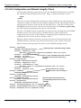
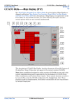
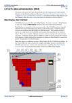
INTREPID User Manual
Library | Help | Top
Setting up the GDADS Front-Office (D06)
1
| Back |
Setting up the GDADS Front-Office (D06)
Top
The second main function of GDADS is to provide a customer-user with access to
data. Because this is typically public access, there are three important
considerations.
•
Security—the interface must ensure system and data security, and maintain data
confidentiality
•
Ease-of-Use—the interface must be robust, intuitive, simple, but effective
•
Real-time Responsiveness—the system must allow simple, real-time image
manipulation
For these reasons, GDADS (for customer-user access) is generally installed on a
separate computer, working with a copy of the data. In this manual, this customeruser access computer environment is referred to as the Front-Office.
Checklist
1
Customise GDADS to its Front-Office style of interface
2
Copy the (necessary) ONLINE data files to the Front-Office computer
3
Copy the database to the Front-Office computer
4
Ensure that confidential data files and database records are removed from the
Front-Office computer
Front-Office Computer
Hardware and Network Resources
General hardware and operating system requirements for GDADS are noted in
Section "Hardware and Operating System Suitability" in Installing GDADS (D02)
Since the Front-Office computer is typically a public interface to the organisation's
data, it should be a quality computer with sufficient processing speed to allow
effective imaging in real time. Disk storage requirements are not large, since only a
part of the data needs to be copied to the Front-Office. Only the grids that are
actually used by GDADS in visualisation need to be copied. In summary, the
requirements are:
Library | Help | Top
•
Near state-of-the-art processor—for effective, real-time image manipulation and
visualisation.
•
Disk storage capacity—sufficient to store all grid files used in visualisation.
(Local disk storage is much preferred compared to network access to the master
files of the on-line data. Security of the master copy of the data is the main
consideration, but also local disk access ensures more effective real-time image
manipulation, compared to accessing files across a network).
•
Network access for GDADS file maintenance, and processing data or map orders
in the Back-Office
•
Access to a (network?) printer (standard page printer)—the Purchase Data wizard
prints a hard copy order.
•
Access to email—the Purchase Data wizard sends an email message to the data
administrator
© 2009 Intrepid Geophysics
| Back |
INTREPID User Manual
Library | Help | Top
Setting up the GDADS Front-Office (D06)
2
| Back |
System Security
GDADS does not provide any system or network security. It is entirely the
responsibility of the organisation's system administrator to ensure that there is no
possibility of customer-user access to any part of the Front-Office computer system, or
to the computer network. The system should have a password protected log-in, which
should be executed be an office clerical assistant. Once logged in, the system must
allow access only to customer-user executables. All other executables and system
administrative tools must be excluded from the public log-in interface (except for the
system log-off or shutdown functions). In other words, everything should be removed
from the Windows desktop and Windows 'start' menu, including simple system
'basics' such as 'Windows Explorer'.
All system administrative (and GDADS data administrative) functions must be
operated from a separate, password-protected administrator's log-in.
Data Security and Confidentiality
Data security can be considered from two viewpoints
•
Ensuring the stored data cannot be corrupted by any inappropriate access to the
stored data files
•
Preventing any public access to (or even knowledge of) data held by the
organisation in confidence.
Data Security
It is entirely the responsibility of the GDADS data administrator to ensure that
GDADS is configured correctly for the Front-Office, and that all of GDADS data
administrative capabilities are disabled in the Front-Office environment. GDADS—
when correctly configured for the Front-Office—does not allow any direct access to
data files. Rather, it allows only the possibility of viewing database information
about surveys, and visualising data, with limited real-time manipulation of that view
of the data. No data editing or file deletion is possible.
A further level of basic data security is guaranteed by setting up a Front-Office which
works with a copy of the data. The main data store—on the Back-Office computer—
would remain secure.
Data Confidentiality
GDADS does not provide any capability for maintaining confidentiality of any
dataset. Even if the GDADS database has a 'confidential' flag, GDADS is currently
not configured to use such a field. Data confidentiality is entirely the responsibility of
the data administrator. The data administrator should:
Library | Help | Top
•
Set up a Front-Office copy of the data which excludes all confidential datasets
•
Remove the records of confidential surveys from the Front-Office copy of the
GDADS database
© 2009 Intrepid Geophysics
| Back |
INTREPID User Manual
Library | Help | Top
Setting up the GDADS Front-Office (D06)
3
| Back |
GDADS Disk Directory Structure (Front-Office)
The setup of GDADS in the Front-Office must be identical to that in the Back-Office.
The setup of the various directories used by GDADS, and the associated specification
of those directories in the configuration file, is documented in Section "GDADS
System Files and Directory Structure" in Installing GDADS (D02)
The reason why the two environments must be identical is because of the way in
which the data purchasing (and map making) process operates. Essentially the tasks
of creating a map, or scissoring out a subset of data, are not actually done by the
customer-user. Rather, a batch job script is set up to do the task. That script—set up
in the Front-Office—is ultimately executed in the Back-Office (where all grid and line
data files are 'on-line', or are retrieved from archive). For the script to execute all
tasks correctly, the directory structures of Front-Office and Back-Office must be
identical.
Front-Office Copy of the ONLINE Data
important—confidential datasets
Do NOT copy any confidential datasets to the Front-Office copy of the GDADS
ONLINE directory disk storage.
GDADS does not provide any function for maintaining confidentiality. It is entirely
the responsibility of the data administrator to ensure that confidential data are not
available in the Front-Office, where they could be inappropriately accessed or viewed
by customer-users.
The Front-Office copy of the ONLINE data does not need to be a complete copy. In fact,
only a small part of the overall datasets has to be copied to the Front-Office computer.
The basic requirements are:
•
Only the grid files actually used by GDADS for visualisation must be copied.
(This includes the country-wide GridMerge grid files, and just the main grid file
for each product type available for sale. Thus, the magnetics grid must be copied,
but additional grids such as 1st vertical derivative and reduction to the pole are
not required)
•
Line data files are not needed, BUT, if line data are available for sale, the
linedata directory must exist. (GDADS' Purchase Data wizard uses the
existence of the linedata directory to flag that 'linedata' is one of the 'product
flavours' available for sale in the 'shop').
•
As noted, the directory structure must be identical (EXCEPT as noted in (4)
below). So, for a typical Survey_Directory, this would include the two
subdirectories, grids and linedata (even though the line data files themselves
do not need to be copied to the Front-Office).
•
Arbitrary 'extra' directories only need to be duplicated to the Front-Office copy if
they are used for data visualisation or product sales.
Using the example scenario from Section "Organising the Data Files in GDADS
ONLINE Disk Storage" in GDADS data administration (D04), the Front-Office copy
would have a directory structure as follows. No 'extra' directories are needed. No line
data are needed (but the linedata directory must exist if line data are available for
sale). Only the main grid files (used for visualisation) are copied. None of the 'extra'
grid files need to be copied.
Library | Help | Top
© 2009 Intrepid Geophysics
| Back |
INTREPID User Manual
Library | Help | Top
Setting up the GDADS Front-Office (D06)
4
| Back |
ONLINE (GDADS Data Directory)
|
country-wide (GridMerge) files for magnetics, totalcount, potassium,
uranium,
|
thorium, em and gravity--used for visualisation and map making.
|
|--- Survey1_Directory
|
|---magnetics
|
|
|---linedata (typically empty--but the directory must exist if data
are 'for sale')
|
|
|
(The INTREPID line dataset is not used in Front-Office)
|
|
|---grids
|
|
|
Only the main files (magnetics & magnetics.ers) are needed
|
|
|
(any 'extra' files, such as 1VD, RTP, DEM, are not needed)
|
|
\---any_other_arbitrary_subdirectory(ies) ARE NOT NEEDED.
|
|
|
|---radiometrics
|
|
|---linedata (typically empty, but the directory must exist if data
are 'for sale')
|
|
|
(The INTREPID line dataset is not used in Front-Office)
|
|
\---grids
|
|
Only the main files are needed:
|
|
files totalcount & totalcount.ers
|
|
files potassium & potassium.ers
|
|
files uranium & uranium.ers
|
|
files thorium & thorium.ers
|
|
(any 'extra' files, such as K_cps, K_percent, are not needed)
|
|
|
\---any_other_arbitrary_subdirectory(ies) ARE NOT NEEDED.
|
|--- Survey2_Directory
|--- Survey3_Directory
|--- ...
Front-Office Copy of the GDADS Database
Important—confidential datasets
In making a Front-Office copy of the GDADS database, REMOVE any records which
refer to confidential datasets.
GDADS does not provide any function for maintaining confidentiality. It is entirely
the responsibility of the data administrator to ensure that all references to
confidential data are not available in the Front-Office, where they could be
inappropriately accessed or viewed by public access users.
A copy of the GDADS database is needed in the Front-Office. In updating the FrontOffice copy of the database, it is essential that any records of 'confidential' surveys are
removed from the Front-Office copy. Note that, for a given confidential survey, both
the SurveyInfo record, and the Outlines record (containing the survey boundary
polygon) must be removed.
Library | Help | Top
© 2009 Intrepid Geophysics
| Back |
INTREPID User Manual
Library | Help | Top
Setting up the GDADS Front-Office (D06)
5
| Back |
Customise GDADS to the Front-Office
As documented in Section "Software Configuration (Part2) Configuration File
Properties.txt" in Installing GDADS (D02), GDADS is 'configured' using a special
configuration file. An environment variable (INTREPID_GDADS) must be set to
point to this configuration file. The configuration file tells GDADS many of the things
that it needs to know about the location of needed files and working directories. It
also includes numerous parameters such as those about products for sale, costs of
those products and the range of available map scales for map production. The other
very important thing that can be achieved through the configuration file is to
fundamentally modify the GDADS interface.
Customising the GDADS User Interface
The user interface for GDADS Front-Office must have a simple, intuitive interface,
suitable for the customer-user. At the same time, all data administrative
functionality needs to be disabled. This is done by modifying several parts of the
configuration file. Given that there are typically so many small changes needed,
however, GDADS is supplied with two configuration files:
Properties.txt
Configured for GDADS Back-Office data
administrative tasks
FO_Properties.txt
Suited to the Front-Office function
Thus, a simple way to configure GDADS to its two differing roles is to maintain the
two configuration files, and modify the environment variable, INTREPID_GDADS,
according to requirements. Thus, in the Front-Office, the computer's environment
variable might be set as follows:
INTREPID_GDADS=C:\gdads\admin\FO_Properties.txt
The changes that must be made to alter GDADS user interface are noted here briefly,
but are documented fully using 'comments' in the Front-Office version of the file,
FO_Properties.txt (included as "GDADS Front-Office config file
FO_Properties.txt (D19)"). The main changes are in the section entitled 'Look
and Feel'. Some of the keyword lines add special capabilities to GDADS Front-Office,
such as the shortcut (right-click) menus, and their associated actions:
GDADS.properties.map.RHpopup.labels = Image View,Purchase Data,|,Properties
GDADS.properties.map.RHpopup.actions = intrepid,buydata,|,info
Many of the keyword lines that are added to the file are used to 'switch off' parts of
the interface—effectively removing all of those buttons and menus which are the data
administrative portion of GDADS. These are illustrated in the following example
segment of the FO_Properties.txt file.
Library | Help | Top
© 2009 Intrepid Geophysics
| Back |
INTREPID User Manual
Library | Help | Top
Setting up the GDADS Front-Office (D06)
6
| Back |
# Turn off options in initial pane
#
# Map Display 'drag & drop panels' along the right-hand side
# .map.ftp = false
false=Do not show the FTP panel
# .map.order = false false=Do not show the Purchase Data panel
# .map.connection = false false=Do not show the Database Connections panel
# Map Display buttons along the top-left toolbar
# .map.toolbar.openfile = falsefalse=Do not show the Open File button
# .map.toolbar.opendb = falsefalse=Do not show the Open Database button
# .map.toolbar.zoomextent = falsefalse=Do not show the Zoom to Extents button
# .map.toolbar.query = falsefalse=Do not show the SQL Query Builder button
# .map.toolbar.help = falsefalse=Do not show the Help button
#
GDADS.properties.map.ftp = false
GDADS.properties.map.order = false
GDADS.properties.map.connection = false
GDADS.properties.map.toolbar.openfile = false
GDADS.properties.map.toolbar.opendb = false
GDADS.properties.map.toolbar.zoomextent = false
GDADS.properties.map.toolbar.query = false
GDADS.properties.map.toolbar.help = false
Customising 'Products for Sale'
The main function of GDADS in terms of facilitating 'public' access to data is to
enable a customer-user to find available data, to view those data, and actually place
an order for those data. To do this, GDADS needs to know 'what data are available
for sale'. This is done through a combination of the configuration file, the GDADS
database, and an associated directory structure and file naming conventions in the
GDADS ONLINE data disk store. The basic requirements are noted here, but are
documented more fully in "Modifying the GDADS database design (D16)" (relating to
GDADS database design), and also using 'comments' in the Front-Office version of the
file, FO_Properties.txt (included as "GDADS Front-Office config file
FO_Properties.txt (D19)").
In summary, the convention used within GDADS is analogous to a 'shop', having
various products for sale, each of which may have various flavours.
Products
•
Are major data categories, such as magnetic data, radiometric data.
•
Must each be defined in the database, with a Boolean data type.
•
Since these have a 'special' data type, these fields must also be recorded in the
GDADS_FIELDINFO table of the GDADS database, with their data type recorded
as 'CheckBox'
•
Must be specified in the Properties.txt configuration file. For example, by
specifying the following three fields (magnetics, radiometrics and em), GDADS is
able to query the database, and offer data for sale if any of these fields are
'checked'. Note that these field names must be written exactly as defined in the
database (case-sensitive). Optionally, a related entry can be specified in
Properties.txt, which are corresponding 'labels' that can be used in the
GDADS interface, and in the title portion of hardcopy maps.
GDADS.properties.buydata.products = magnetics,radiometrics,em
GDADS.properties.buydata.products.labels = Magnetics,Radiometrics,EM
Library | Help | Top
© 2009 Intrepid Geophysics
| Back |
INTREPID User Manual
Library | Help | Top
Setting up the GDADS Front-Office (D06)
7
| Back |
•
Must also be the names of subdirectories under the main survey dataset directory
in the GDADS on-line data storage area of the disk.
•
Grids with these names must exist within the 'product_name'\grids
subdirectories
Note the very important integration that is essential between the configuration file,
the database, the directory structure and file naming conventions
Flavours
GDADS uses flavours as a further breakdown of 'products for sale'. These are not
specified in the database, but they are entries in the Properties.txt configuration
file, and they also must have corresponding subdirectories in the on-line datastore (if,
indeed, those data are for sale for a given survey).
GDADS.properties.buydata.flavours = Grids,LineData
An example directory structure associated with these products and flavours is
illustrated
GDADS_ONLINE_Data_Directory
|
|--- Survey1_Directory
|
|---magnetics
< 'Product'
|
|
|---linedata< a 'Flavour' of the 'Product'
|
|
\---grids< another 'Flavour'
|
|---radiometrics< another 'Product'
|
|
|---linedata< ...
|
|
\---grids
|
|---...
|
|--- Survey2_Directory
Customising Pricing of 'Products for Sale'
In addition to informing GDADS that certain products are 'for sale', the configuration
file must also include the prices for data products, and also some specifications of
maps for sale, and their prices. For data sales, a price must be set for each
combination of Product and Flavour which is actually for sale, as illustrated in the
example segment of the FO_Properties.txt file below.
It is important to define how units of distance are used in GDADS. To summarise a
typical case, assume that, for the Projection specified for the GDADS database,
distances are measured in metres, then:
Library | Help | Top
•
GDADS needs to know the survey line spacing, expressed in m
•
GDADS calculates areas (for example, the area of a survey) in km2
•
GDADS calculates survey line distances (based on area and line spacing) in line
kilometres
•
Costs for data sales are expressed in cost/km2 (grid data) and cost/line-kilometre
(line data)
© 2009 Intrepid Geophysics
| Back |
INTREPID User Manual
Library | Help | Top
Setting up the GDADS Front-Office (D06)
8
| Back |
The specification (in the configuration file) of the field name for the line spacing field,
and the inclusion of that field in the database design, is documented in "Modifying
the GDADS database design (D16)". For GDADS to correctly estimate line
kilometres, it is essential that the line spacing (for each survey) is correctly entered
into the database, and that each survey's boundary polygon does accurately delineate
the survey's data extents.
Examples of the specification of the cost figures for grids and line data are included in
the following segment from the configuration file, FO_Properties.txt. Notice also
the definitions related to map products, and the specification of prices for those. See
also the 'comments' in the Front-Office version of the file, FO_Properties.txt
(included as "GDADS Front-Office config file FO_Properties.txt (D19)").
# PRICES expressed in (Namibian Dollar/line-kilometre) or (Namibian Dollar/
square kilometre)
#
GDADS.properties.buydata.magnetics.LineData.price = 10
GDADS.properties.buydata.radiometrics.LineData.price = 1
GDADS.properties.buydata.em.LineData.price = 20
GDADS.properties.buydata.gravity.LineData.price = 20
GDADS.properties.buydata.magnetics.Grids.price = 2
GDADS.properties.buydata.radiometrics.Grids.price = 15
GDADS.properties.buydata.em.Grids.price = 25
GDADS.properties.buydata.gravity.Grids.price = 20
# .buydata.Maps.products —Range of available hard copy map scales
# .buydata.Maps.fittoscale —names of map templates for which a 'fit-to-page'
option is enabled
# .buydata.Maps.5000000.price, ... —Hard copy Map prices in Namibian Dollar /
Map Plot
# .buydata.GeoTiffs.price —GeoTiff bitmap image file price in Namibian Dollar /
BitMap File
#
GDADS.properties.buydata.Maps.products =
5000000,2000000,1000000,250000,100000,50000,25000
GDADS.properties.buydata.Maps.fittoscale = A4P,A4L,A3P,A3L
GDADS.properties.buydata.Maps.5000000.price = 1000
GDADS.properties.buydata.Maps.2000000.price = 1000
GDADS.properties.buydata.Maps.1000000.price = 1000
GDADS.properties.buydata.Maps.250000.price = 500
GDADS.properties.buydata.Maps.100000.price = 300
GDADS.properties.buydata.Maps.50000.price = 50
GDADS.properties.buydata.Maps.25000.price = 50
GDADS.properties.buydata.GeoTiffs.price = 50
Library | Help | Top
© 2009 Intrepid Geophysics
| Back |
INTREPID User Manual
Library | Help | Top
Setting up the GDADS Front-Office (D06)
9
| Back |
Customising the Initial Public View of GDADS
In designing the Front-Office implementation of GDADS, the aim was to provide a
simple, graphical and highly intuitive interface. The initial 'view' which GDADS
presents to the customer-user is a 'map view' of the GDADS database project area.
The view shows all 'surveys' as distinctive polygon objects. These are typically
rendered onto a background layer of 'standard map sheets', which are themselves also
polygon objects (of a different colour). A 'country' outline is drawn on top of the
display to provide a broad regional context. This initial display can be customised
through the configuration file, FO_Properties.txt. Some selected examples of this
customisation are noted here, but for full details of the customisation options see the
internal documentation in FO_Properties.txt (included as "GDADS Front-Office
config file FO_Properties.txt (D19)").
Set a flag for GDADS to automatically load the database, and show the Map Display
GDADS.properties.open.auto = true
'Turn off' all of the 'drag & drop' panels used in the Back-Office version of GDADS
GDADS.properties.functions = false
Set a flag for GDADS to use selectable 'layers' (for example, the surveys layers, a map
sheets layer)
GDADS.properties.layers = true
Set up the contents (and associated actions) of the shortcut (right-click) menu
GDADS.properties.map.RHpopup.labels = Image View,Purchase
Data,|,Properties
GDADS.properties.map.RHpopup.actions = intrepid,buydata,|,info
Set up the initial (and 'reset') display limits
GDADS.properties.map.extents.longitude.min = 11
GDADS.properties.map.extents.longitude.max = 26
GDADS.properties.map.extents.latitude.min = –29
GDADS.properties.map.extents.latitude.max = –16
Library | Help | Top
© 2009 Intrepid Geophysics
| Back |
INTREPID User Manual
Library | Help | Top
Setting up the GDADS Front-Office (D06)
10
| Back |
GDADS Configuration and Dataset Integrity Check
A small utility function is provided to assist the GDADS administrator in checking
the integrity of the GDADS system setup. From a command window, execute:
gdads
—check
This process runs a background check on the whole GDADS setup, and checks the
consistency within and between the GDADS configuration file, the GDADS database
and the survey datasets stored in the 'on-line' disk store. A log file is written into
INTREPID's 'temp' directory, which is (by default) located in install_path\temp.
No GUI interface is popped up; the process runs silently.
The types of GDADS system checks that are done include checking that the GDADS
database exists, and can be opened, checking that key tables listed in the
configuration file do exist in the database, checking that key fields listed in the
configuration file do exist in those database tables.
The data checks look for consistency between the survey datasets listed in the
GDADS database, and the survey dataset directories in the 'on-line' disk store.
Extract from the Intrepid log file written by the GDADS integrity check.
Survey: surveyOz5
Setting of the 'confidential' flag is noted.
ONLINE confidential=false
Product: magnetics true
Warning: Directory magnetics\LineData does not exist
Product: radiometrics false
The linedata subdirectory does not exist
Product: em false
(possibly correct, but the warning is
Product: gravity false
issued)
Survey: Diamond_SE
ONLINE confidential=false
Product: magnetics true
Product: radiometrics true
Warning: Grid in radiometrics\Grids does not exist
Product: em true
Survey listed in the GDADS
Product: gravity true
database, but is not currently onSurvey: Diamond
line.
OFFLINE confidential=false
Survey: Diamond_NW
OFFLINE confidential=false
Survey: Rehoboth_Part
Directories that exist, but have no
OFFLINE confidential=false
corresponding entries in the GDADS
Survey: WindyPlace
database
OFFLINE confidential=false
Survey: TestPartDiamond has no database entry
Survey: TestPartRehoboth has no database entry
Survey: Windhoek has no database entry
Library | Help | Top
© 2009 Intrepid Geophysics
| Back |