1
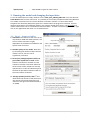
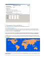
Global to Neighborhood Scale Anthropogenic Heat Flux model: LUCY - Large scale Urban Consumption of energY User Manual - Version 2014a Fredrik Lindberg & CSB Grimmond Web page: http://londonclimate.info Email: [email protected] Table of Contents 1. 2. 3. 4. Changes from Previous Versions ..................................................................................................... 1 Installation ....................................................................................................................................... 2 Running the model and changing the input data ............................................................................ 3 3.1. Step 1 - Input variables ............................................................................................................ 3 3.2. Step 2 - Choose region selection method ............................................................................... 4 3.3. Step 3a – Choose input population data ................................................................................. 5 3.4. Step 3b – Choose pixel resolution ........................................................................................... 5 3.5. Step 4 - Choose output folder name ....................................................................................... 5 3.6. Step 5 - (Optional) Change input data ..................................................................................... 5 3.7. Additional options ................................................................................................................... 5 3.8. EXECUTE and Data Summary Window .................................................................................... 5 Changing the Data in the Model ..................................................................................................... 6 4.1 Gridded datasets ........................................................................................................................... 6 4.2 Country based statistics ................................................................................................................ 7 5. 6. 7. Output data ..................................................................................................................................... 8 Acknowledgements: ........................................................................................................................ 8 References ....................................................................................................................................... 8 How to install and use LUCY to compute anthropogenic heat flux (AHF) for a number of cities or regions around the world. A detailed description of the model can be found in Allen et al. (2011) and Lindberg et al. (2013). The current formal reference for the model is: Allen L, F Lindberg, CSB Grimmond (2011) Global to city scale model for anthropogenic heat flux, International Journal of Climatology, 31, 1990-2005. Lindberg F, Grimmond CSB, Nithiandamdan Y, Kotthaus S, Allen L (2013) Impact of city changes and weather on anthropogenic heat flux in Europe 1995–2015, Urban Climate, 4, 1-15. http://dx.doi.org/10.1016/j.uclim.2013.03.002 1. Changes from Previous Versions Version Released 2014a 14 June 2014 2013b 27 May 2013 2013a 15 March 2013 30 June 2012 4.0 16 June 2014 Changes from previous version 1. 2. 3. 4. 1. A bug concerning the use of daily temperature grids resolved 32-bit version is now available (MCR version 8.2). A bug concerning the GWP dataset is resolved. A new installation procedure is introduced. A new global population dataset, GRUMP v1 (CIESIN, 2011), is introduced as well as opportunity to alter the spatial resolution. 1. A new weighting scheme for energy use based on Cooling Degree Days and 1|LUCY 3.1 3.0 2.2 2.1 2.0 22 August 2011 1 July 2011 18 Jan 2011 1.0 0.0 Heating Degree Days 2. Migrated to 64-bit MATLAB Compiler Runtime (version 7.14) which can cope with larger model domains. This makes the option introduced in version 2.2 obsolete. 1. Major bugs fixed 2. Opportunity to only consider pixels classified as urban. 1. Possibility to run any time period between 1900 and 2100. However, the success of the execution is highly dependent on the datasets available for the specific time of interest. 2. Monthly datasets can be used instead of average monthly temperature dataset (1960-90). 3. Reduction of the size of the mandatory input datasets. 1. Possibility to run large model domains 1. Possibility to change model inputs 1. Introduction of improved response to air temperature which extends latitudinal range ( see Lindberg et al 2011 Manuscript in preparation – contact Sue Grimmond for a copy) 2. Graphical User Interface (GUI) introduced As published in Allen et al. (2011) As described in Allen (2009) Master’s thesis 2. Installation This model is written in MATLAB and is executed using the MATLAB Compiler Runtime (MCR), which can be distributed royalty free. Hence, the user can run the model without having a MATLAB license or any skills in MATLAB programming. The MCR runs on 64-bit and 32-bit WINDOWS NT/2000/XP/Vista/7 platforms and the current version of the MCR connected to the software is 8.2 and can be downloaded from: http://www.mathworks.se/products/compiler/mcr/ To run the model MCR must be installed locally on the computer that will be used. To install the software, download and install LUCY Install (XX-bit).exe. By using the installation file, all data and executables will be located as described below.. Main executable files in installation folder: LUCY_GUI_v2014a_XXbit.exe Main model mat2ascGUI_XXbit.exe Translation tool between MATLAB binary format and ESRI ASCII raster All files and data will be located in the same folder system. The structure of data is shown below (IMPORTANT! Do not change the file and folder structure!). \Data\ \Data\countries\ \Data\DataGPW\ \Data\population\ - \Data\temperature\ - 16 June 2014 Main data folder includes text files concerning e.g. holidays traffic etc. Tiled GRUMP v1 grids of country extent and ID. Global population density grids based on GPW v3 (CIESIN, 2011). Tiled GRUMP v1 grids of population density for 2000. More grids are available (see Section 4.1). Here, global monthly temperature datasets for 1970-2000 is located. If alternative datasets (monthly) is used than these files should be located in this folder. The same goes for daily temperature grids. 2|LUCY \Data\urban\ - Tiled GRUMP v1 grids of urban extents. 3. Running the model and changing the input data To run the model the user simply needs to run the LUCY_GUI_v2014a_XXbit.exe or use the shortcut LUCY 2014a found from the start menu. It is possible to use monthly temperature datasets (Willmott et al. 2009). Instruction how to use this datasets are found in Section 4.1. LUCY comes with a Graphical User Interface (GUI) which opens this window when the program is executed. An error logfile is generated in the installation folder if any runtime related issues occurs. The error file will not be created if the user is not allowed to write this folder. To make sure that a logfile is used, right click on the application and chose ‘run as administrator’. 3.1. Step 1 - Input variables 1. Start date: This feature let the user run any day between 1900 and 2100. However, the success of the execution is highly dependent on the datasets available for the specific time of interest. 2. Number of days to run model: Note that by increasing the number of days that the model is run for, the run time is significantly increased. 3. Factor (0-1) multiplying total vehicles to get number of vehicles on road: Traffic statistics are based on number on total number of vehicles. This factor allows for what fraction of the vehicles are actually operational so a value of 0.8 assumes that the fleet of operational vehicles is 80% of the total number of vehicles. 4. Average speed of vehicle in km h-1: This determines the amount of fuel and hence, the amount of heat exhausted by each vehicle in each grid cell based on Smith et al. (2009). 16 June 2014 3|LUCY 3.2. Step 2 - Choose region selection method Due to the high spatial resolution of the model the computational time for running the whole world is very high. Therefore, a number of options to select smaller model domains are available: 1. Select Country: This option let you choose a region based on a specific country. 2. Select region from world map: This option makes is possible to define a larger region on a global map to be modelled. Remember, the larger region selected the longer the model run will take. Choosing too large a region may cause memory failure and the model will not run. 3. Specify region using lat/long coordinates: Latitude: positive are Northern Hemisphere, Longitude: positive are west). To run whole world: The easiest way to do this is to specify the following coordinates: Min latitude:-58 Min Longitude=-180 Max Latitude=85 Max Longitude=180 Note: this will be very slow if more than a day (e.g. 2h/day) and there may be memory issues depending on your computer. 16 June 2014 4|LUCY 3.3. Step 3a – Choose input population data There are two different population density datasets to choose from: GRUMPv1: Gridded Rural-Urban Mapping Project. This dataset is gridded at 30’’ x 30’’ resolution with a latitudinal range of 82°N to 58°S and is available for the years 1990, 1995 and 2000 (CIESIN, 2011). GPWv3: Gridded Population of the World. This dataset is gridded at 2.5’ x 2.5’ with a latitudinal range of 85°N to 58°S and is available for the years 1990, 1995, 2000, 2005, 2010 and 2015 (CIESIN, 2011). 3.4. Step 3b – Choose pixel resolution If the GRUMPv1 dataset is chosen in step 3a, it is possible to change the spatial resolution in LUCY. The different pixel resolution available is 30’’, 60’’, 2.5’, 5’, 10’ and 0.5°. If the GPW is chosen in step 3a the spatial resolution is fixed to 2.5’. 3.5. Step 4 - Choose output folder name Here, an output folder must be specified where model results can be saved. Make sure that you have write access to the specified folder. 3.6. Step 5 - (Optional) Change input data This makes it possible to use daily mean air temperature grids as global datasets at 2.5’ resolution with a latitudinal range of 85°N to 58°S. See Section 4 for further details. 3.7. Additional options Show hourly map of Anthropogenic Heat Flux during execution: This will display a map of the hourly evolution of the AHF for the model domain. If this option is chosen the model will take longer to execute. Only consider pixels classified as urban pixels: This will use a mask grid where only urban pixels will be picked out for the calculation of AHF. Save anthropogenic heat flux images as ESRI ASCIIgrid: This will output anthropogenic heat flux grids as ESRI ASCII grids which could be loaded into almost any GIS software system available. Save population density as ESRI ASCIIgrid: This will output population density grids (persons/km2) as ESRI ASCII grids which could be loaded into almost any GIS software system available. 3.8. EXECUTE and Data Summary Window To start the calculation using the settings made in Step 1 to Step 5, Press EXECUTE. Data Summary1 window provides information of the available datasets that will be used for the specific time period chosen in STEP 1. 1 Version 3.0 and later. In earlier versions data such as energy consumption and traffic was represented as large grids valid for the year 2005. Now that data has been moved from grids to tables to reduce the size of the data folder and also to be able to model other years than 2005. 16 June 2014 5|LUCY 4. Changing the Data in the Model The datasets that can be changed in LUCY are described in this section. 4.1 Gridded datasets Some of the input gridded datasets such as population and temperature can be changed. It is also possible to export the input data grids to explore it in other software systems (e.g. QGIS). To export and import new data, run: mat2ascGUI.exe. Since the base data comes in two different spatial resolutions and extents based on the population datasets (see section 3.4), it is possible to import and export both versions (GPWv3 and GRUMPv1). GRUMPv1 comes in 5° x 5° tiles: It needs to be exported and imported using the tiles shown on the world map below. The latitudinal intervals start from -58° (58°S). Tiles occupied by only ocean cannot be exported. GPWv3 datasets are not tiled and will be exported as global datasets with the with a latitudinal range of 85°N to 58°S. 16 June 2014 6|LUCY Any dataset to be imported should be in ASCII raster format and have the same spatial extent and resolution as all the other input datasets. The easiest way to obtain this information is to export the current datasets using: mat2ascGUI.exe The ASCII raster grids that can be retrieved and exported from the database (if they exist) in the current version are: 1. Population density 2. CountryID grid 3. Default monthly temperature grids 4. Daily average temperature grids In the current version it is possible to use daily temperature input data. Since the model is able to model sequential days, a dataset needs to exist for each day of interest. Daily temperature files should be stored in the temperature folder. The name of each file will be Dailytemp_YYYY_DOY.mat. If the mat2ascGUI.exe program is used this is automatically stored in the correct folder with the correct name based on year and day of year. Currently there is only possible to include daily datasets based on the same resolution and spatial extent as the GWPv3 dataset. To include additional monthly temperature data, it should be in the format used by Willmott et al. (2009). Monthly data for 2005 is included in the installation of LUCY. You can examine the format by opening air_temp.2005 (located in the temperature folder) in a regular text editor. Additional data for any month between 1900 and 2010 are available for download from University of Delaware. Data to be used are Terrestrial Air Temperature: 1900-2010 Gridded Monthly Time Series (V 3.01) which can be unzipped, located in the temperature folder and used directly in the LUCY (http://climate.geog.udel.edu/~climate/). The direct link to the full dataset is: http://climate.geog. udel.edu/~climate/html_pages/Global2011/Global2011T.tar.gz. If the format and filename (e.g. air_temp.YYYY) is kept it is also possible to include any other gridded monthly temperature dataset. 4.2 Country based statistics Annual energy consumption and vehicle numbers are stored in tables. The latest version of these tables can be accessed and downloaded from Google documents linked from the LUMA data archive. Here you can also find more detailed information about these datasets and where they originate from. If new data are prepared we would appreciate receiving a copy or to update the Google documents to allow others to use it. Please make use of LUMA to do this. Annual energy consumption and vehicle numbers are stored in tables giving data = country and year specific values source = external data source which provided the data user = LUCY user who provided the data The latest version of these tables can be accessed and downloaded from Google documents links provided. The spreadsheet view should also be used to edit and expand the datasets if you are able to provide information not yet present in the database. Each ‘data’ sheet is linked to a sheet specifying the external data ‘source’ and the LUCY ‘user’ who provided the data. Please make sure that all three sheets are filled in, when submitting new information. In order to keep these meta tables tidy, please enter source and user in form of ID numbers. Translation of source ID numbers (e.g. S001) and user ID numbers (e.g. U001) is accomplished in the meta data tables which you can find in the link called ‘SOURCE/USER’. Again, please specify all external sources. Currently there are three sets of spreadsheets for each dataset available. The ‘basic’ data tables provide the information available in the LUCY model at download stage. ‘Basic’ data tables provide the information available in the LUCY model at download stage. Sometimes several values from different data sources are 16 June 2014 7|LUCY available for the same country and year – that is if they are provided by different external sources. these supplement information is stored in data tables 2 and 3. To use an updated version of the spreadsheets, export them as plain text-files from the Google spreadsheets and name them Energy.txt, Cars.txt, Freights.txt or Motorbikes.txt depending on what information you have updated. Overwrite the old file which is found in the main folder of the model. You might want to save a copy of the old file. 5. Output data The output data files from the model will be created in the output folder as specified in Step 4. Files that are created are: 1. A statistics file consisting of time series of anthropogenic heat flux. If a certain country is chosen in STEP 2 (Section 3.3) statistics will only be calculated using the grids within the specific country. 2. Hourly ASCII matrices (.txt) of AHF as well as an averaged matrix for the whole model period. These will be save as ESRI ASCII grids if this option is chosen. 3. An ASCII raster header which could be used for importing the results into GIS software systems as well as obtaining information about spatial resolution and location. The header includes the following information: ncols nrows xllcorner yllcorner cellsize NODATA_value number of columns of the matrix number of rows of the matrix geographic “x” coordinate of the lower corner of the matrix geographic “y” coordinate of the left side of the matrix in lat long -9999 6. Acknowledgements: People who have contributed to the Model Development: Lucy Allen, Fredrik Lindberg, Sue Grimmond, Simone Kotthaus, Nithiyanandam Yogeswaran People who have contributed to early versions of this manual: Susie Kinghan We thank those users who have provided feedback to allow this to be improved. Financial support for this project: NERC ClearfLO, NERC Studentship (L Allen), EUF7 MegaPoli (212520), EUF7 BRIDGE (211345), King’s College London and FORMAS – the Swedish Research Council for Environment, Agricultural Sciences and Spatial Planning. The model is available for download at http://geography.kcl.ac.uk/micromet 7. References Allen L, F Lindberg, CSB Grimmond (2011) Global to city scale model for anthropogenic heat flux, International Journal of Climatology, 31, 1990–2005. CIESIN, Columbia University, and Centro Internacional de Agricultura Tropical (CIAT) (2011). Gridded Population of the World Version 3 (GPWv3): Population Density Grids. Palisades, NY: Socioeconomic Data and Applications Center (SEDAC), Columbia University. [Online]. Available from: http://sedac.ciesin.columbia.edu/data/collection/grump-v1, Accessed on 3 December, 2012. Lindberg F, CSB Grimmond, N Yogeswaran, S Kotthaus, L Allen, (2013). Impact of city changes and weather on anthropogenic heat flux in Europe 1995-2015. Urban Climate, 4, 1-15, http://dx.doi.org/10.1016/j.uclim. 2013.03.002. Smith C, Lindley S and Levermore G (2009) Estimating spatial and temporal patterns of urban anthropogenic heat fluxes for UK cities: the case of Manchester. Theoretical Applied Climatology, 98(1-2), 19-35. Willmott CJ, Matsuura K, Legates DR. (2009) Terrestrial Air Temperature: 1900-2008 Gridded Monthly Time Series (1900-2008) (V. 2.01). [Online]. Available from: http://climate.geog.udel.edu/~climate/html_pages/download.html#lw_temp [Accessed 15 January 2011] 16 June 2014 8|LUCY