1
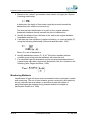
Water Use
Regulatory Method (WAT-RM-16)
Hydrogeologist Input to Groundwater
Abstraction Assessment
Version: v4
Released: Mar 2013
Copyright and Legal Information
Copyright© 2013 Scottish Environment Protection Agency (SEPA).
All rights reserved. No part of this document may be reproduced in any form or in any
means, electronic or mechanical, including (but not limited to) photocopying, recording or by
any information storage and retrieval systems, without the express permission in writing of
SEPA.
Disclaimer
Whilst every effort has been made to ensure the accuracy of this document, SEPA cannot
accept and hereby expressly excludes all or any liability and gives no warranty, covenant or
undertaking (whether express or implied) in respect of the fitness for purpose of, or any
error, omission or discrepancy in, this document and reliance on contents hereof is entirely
at the user’s own risk.
Registered Trademarks
All registered trademarks used in this document are used for reference purpose only.
Other brand and product names maybe registered trademarks or trademarks of their
respective holders.
Update Summary
Version Description
v1.0
First issue for Water Use reference using approved content from the following
documents:
GWABS_8_v1_19_Hydrogeologist_Input_to
_the_assessment_of_Groundwater_Abstraction_Impacts.doc
v2.0
Changes made to reflect difference in abstraction rate for the simple/complex
licence cut-off
v2.1
Header info revised, minor typos corrected.
v3
Doc simplified to remove repeated info and updated to reflect changes to WATRM-11 and revised Form references..
v4
Expired CMS links reviewed and updated.
Notes
References: Linked references to other documents have been disabled in this web version
of the document. See the References section for details of all referenced documents.
Printing the Document: This document is uncontrolled if printed and is only intended to be
viewed online.
If you do need to print the document, the best results are achieved using Booklet printing or
else double-sided, Duplex (2-on-1) A4 printing (both four pages per A4 sheet).
Always refer to the online document for accurate and up-to-date information.
2 of 40
Uncontrolled if printed
v4 Mar 2013
Table of Contents
1. Introduction......................................................................................................... 5
1.1
Purpose.................................................................................................... 5
1.2
Scope ....................................................................................................... 5
1.3
Legislative Context ................................................................................... 5
2. Principles of Environmental Impact Assessment for Groundwater Abstractions. 6
2.1
Introduction .............................................................................................. 6
2.2
Groundwater Quantitative Status ............................................................. 6
2.3
Screening Assessment............................................................................. 6
2.4
Further Assessment ................................................................................. 7
2.5
Formulation of licence conditions ............................................................. 9
2.6
Groundwater Unit Input to Process .......................................................... 9
2.7
Conceptual Modelling............................................................................... 9
3. Groundwater Dependent Terrestrial Ecosystems (GWDTE) ............................ 11
3.1
Overview ................................................................................................ 11
3.2
Core Assumptions .................................................................................. 11
3.3
Screening Assessment Review .............................................................. 11
3.4
Further Assessment ............................................................................... 12
3.5
Assessment of Information Provided by the Applicant ........................... 13
3.6
Formulation of Licence Conditions ......................................................... 13
4. Other Abstractions ............................................................................................ 14
4.1
Overview ................................................................................................ 14
4.2
Core Assumptions .................................................................................. 14
4.3
Screening Assessment Review .............................................................. 14
4.4
Further Assessment ............................................................................... 15
4.5
The Formulation of Licence Conditions .................................................. 16
5. Impacts on Flowing Surface Waters ................................................................. 18
5.1
Overview ................................................................................................ 18
5.2
Standing Surface Waters ....................................................................... 18
v4 Mar 2013
Uncontrolled if printed
3 of 40
Regulatory Method (WAT-RM-16)
5.3
Core Assumptions .................................................................................. 18
5.4
Screening Assessment Review .............................................................. 19
5.5
Further Assessment ............................................................................... 20
5.6
Formulating Licence Conditions ............................................................. 21
6. Saline Intrusion ................................................................................................. 23
6.1
Overview ................................................................................................ 23
6.2
Core Assumptions .................................................................................. 23
6.3
Screening Assessment Review .............................................................. 23
6.4
Further Assessment ............................................................................... 24
6.5
Formulating Licence Conditions ............................................................. 26
7. Insufficient Resource ........................................................................................ 28
7.1
Overview ................................................................................................ 28
7.2
Core Assumptions .................................................................................. 28
7.3
Screening Assessment Review .............................................................. 29
7.4
Further Assessment ............................................................................... 29
7.5
Formulating Licence Conditions. ............................................................ 31
Appendix 1:
IGARF ........................................................................................... 33
Appendix 2:
Values of T&S Used in Low Flows 2000 ....................................... 35
Appendix 3:
Saline Intrusion Assessment......................................................... 37
References ........................................................................................................... 39
4 of 40
Uncontrolled if printed
v4 Mar 2013
1. Introduction
1.1 Purpose
This document aims to provide guidance for SEPA Groundwater Unit staff on
how to assess of potential environmental impact of a groundwater
abstraction and determine if this complies with the WFD.
This guidance also provides an understanding of the way in which SEPA
considers abstraction impacts and so may be useful to anyone involved with
estimating impacts from groundwater abstractions, such as environmental
consultants.
1.2 Scope
This document deals with the sort of further information which may be
required from the applicant to determine a groundwater abstraction
application as well as assessment of this information to decide if the
abstraction is acceptable. The assessment process is not designed to
undertake estimates of, or guarantee, well yields.
The guidance has been written with respect to licence applications but the
principles will also be relevant to anyone assessing a registration level
abstraction in a sensitive location.
1.3 Legislative Context
The Water Environment and Water Services (Scotland) Act 2003 (WEWS)
transposed the principles of the European Directive 2000/60/EC (known as
the Water Framework Directive or WFD) into Scots law. The Water
Environment (Controlled Activities) (Scotland) Regulations (CAR), provide
the framework of control necessary for groundwater abstractions as required
under the WFD. WEWS makes SEPA the responsible body for assessment
and regulation of abstractions such that the requirements of WEWS, CAR,
and hence the WFD, are met.
v4 Mar 2013
Uncontrolled if printed
5 of 40
2. Principles of Environmental Impact
Assessment for Groundwater Abstractions
2.1 Introduction
The groundwater abstraction licence assessment process is designed to help
Scotland meet the objectives of the WFD. This assessment is undertaken at
two levels:
Screening assessment
Further assessment following site-specific investigations if required.
The tests are designed to see if the abstraction is likely to result in a
deterioration in status of Scotlands groundwater bodies.
2.2 Groundwater Quantitative Status
Good quantitative status of groundwater is achieved if:
There is a surplus of resource over abstraction
There is no long term decrease in groundwater level
Groundwater abstraction causes no failure in ecological objectives for
any associated surface waters, or diminution in status, or prevents the
return to good ecological status of such waters
Groundwater abstraction causes no significant damage to directly
supported terrestrial ecosystems
There is no saline or other intrusion
In addition the WFD aims to safeguard and develop the potential uses of
Community waters.
2.3 Screening Assessment
A series of screening tests needs to be carried out by EPI to assess the
licence application. This is detailed in WAT-RM-11: Licensing Groundwater
Abstractions including Dewatering.
For licences the assessment is based upon a survey of water features
undertaken by the applicant in conjunction with SEPA datasets (e.g.
registered and licensed abstractions).
For licences the assessment is based upon a survey of water features
detailed in WAT-FORM-10: Water Features Survey Identification Form (GW),
undertaken by the applicant in conjunction with SEPA datasets (e.g.
registered and licensed abstractions). The results of each screening test
should be recorded in WAT-FORM-11: Groundwater Abstraction Application
Screening Assessment. The screening assessment is designed to examine
6 of 40
Uncontrolled if printed
v4 Mar 2013
Principles of Environmental Impact Assessment for Groundwater Abstractions
the effects that an abstraction might have which could lead to a failure of
WFD objectives. The tests are as follows:
Surface water Flow Impact Assessment (environmental standards test)
Potential saline intrusion
Adequate Resource test (consult the Groundwater Unit)
Existing abstractions within survey radius
Wetlands within survey radius
England Scotland border within survey area. In such cases, the
consultative procedure with the EA is triggered. This ensures that any
potential problems to the water environment in the Solway Tweed River
Basin Districts are identified.
Each of the above tests are based upon a set of core assumptions. If
potential impacts are identified as a result of the screening assessment and
the abstraction cannot be moved or the volume reduced to remove or lessen
the impact of the abstraction the applicant will be asked to undertake further
site specific investigations. These investigations are designed to demonstrate
the validity or otherwise of the core assumptions, for this particular
abstraction.
Where a potential significant impact is identified the applicant may be able to
supply socio-economic justification for the abstraction. This assessment will
be undertaken by EPI.
2.4 Further Assessment
2.4.1 Information to be submitted by the applicant
The Groundwater Unit should detail the further information required from the
applicant to determine the application on WAT-FORM-12: Groundwater
Abstraction Further Information Requirements. EPI will then use this
information to specify investigation requirements.
In some cases the applicant may wish to test the borehole for a longer period
than we require e.g. for yield testing. SEPA should aim to accommodate any
requests of this kind where this is unlikely to cause unacceptable
environmental impacts. Advice may be sought from Ecology where the
presence of a groundwater dependent wetland is the reason for failure.
For licence applications the applicant must submit the data and an
interpretative report consisting of:
Conceptual model constructed using real data as appropriate
Quantification of impact
v4 Mar 2013
Uncontrolled if printed
7 of 40
Regulatory Method (WAT-RM-16)
Assessment of any reduction in flow, water level or nutrients as
appropriate
2.4.2 Assessment of Information Provided by the Applicant
When assessing the further information supplied by the applicant e.g. test
pumping information or further details on wetlands, you should make use of
WAT-FORM-14: Hydrogeologist Input to Groundwater Abstraction
Assessment.
EPI will only refer those applications for abstraction to you if the interpretative
report submitted by the applicant is not of the required quality, does not
supply the information required or identifies a potential impact.
In such cases you will need to examine the report in detail. Your objective is
to determine if investigation demonstrates that the hydrogeological
assumptions are not justified, and the findings are backed with appropriate
data.
Your examination may need to include some or all of the following:
Examination of the conceptual model and in particular the information
used to validate it
Analysis of test pumping interpretation to check that the most
appropriate aquifer properties have been used in modelling
Examination of data to check that the interpretation of the
hydrogeological conditions is justified
Where relevant, examination of any flow apportioning where the
evidence supports a contribution from more than one surface water
Where relevant, quantification of impact by calculation or modelling of
risk of intrusion, e.g. Appendix 2 in relation to the short term
measurement and long term prediction of groundwater quality trends
induced by pumping.
Where relevant an assessment of significance of any further reduction
in available resource, e.g. surface water flow impacts.
Consultation with Wetland Ecology if wetlands are identified within the
survey area
Having assessed the hydrogeological data and the interpretative report for
adequacy and accuracy you should prepare a short report using WATFORM-14: Hydrogeologist Input to Groundwater Abstraction Assessment
which you should send to EPI who will decide if the abstraction may be
authorised. Any recommendation to refuse the permit application should be
justified in full.
8 of 40
Uncontrolled if printed
v4 Mar 2013
Principles of Environmental Impact Assessment for Groundwater Abstractions
2.5 Formulation of licence conditions
You may be asked by EPI to describe conditions that could be added to the
licence to allow authorisation of the abstraction. If you consider that the
impact could be significant then site specific conditions on the licence may
allow the abstraction to be authorised. This should be detailed on WATFORM-14: Hydrogeologist Input to Groundwater Abstraction Assessment
which should be sent to EPI.
If you decide that adequate conditions cannot be applied to protect the
receptor the abstraction may still be authorised if the applicant can
demonstrate socio-economic justification and this option should be included
in your report. The assessment of socio-economic justification will be
undertaken by EPI.
2.6 Groundwater Unit Input to Process
The Groundwater Unit may be asked to advise the process at a number of
stages of an application:
You may be asked to advise EPI on groundwater resource availability
as part of the screening assessment.
If the screening assessment identifies a potential impact you may be
asked to review the failed test
Where a potential impact is confirmed, and the applicant has agreed to
supply further information, you may be asked to define the scope of an
investigation. Consultation with ecology on this is appropriate where
wetlands may be impacted.
You may be asked to review and comment on an interpretative report
submitted in support of an application to abstract groundwater .
Consultation with ecology on this is appropriate where wetlands may be
impacted.
Sections 3 to 7 provide further information on each assessment test and
Groundwater Unit input to them.
2.7 Conceptual Modelling
You will need to construct a conceptual model of sufficient detail at each
input level. The guidance document WAT-RM-27: Modelling Methods for
Groundwater Abstractions gives more information on the construction of
conceptual models.
An appropriate conceptual model will normally be constructed from
information held on GIS and any other relevant information of which you are
aware, e.g. local borehole logs or groundwater level data, in order to confirm
that the basic assumptions underlying each test apply to the application. It is
important to note that whilst the basic screening will be done using a
v4 Mar 2013
Uncontrolled if printed
9 of 40
Regulatory Method (WAT-RM-16)
standard assumption of radial flow, local geological structures or other
natural or man-made features may cause non-radial flow. This should be
taken into account in your conceptual model.
The development of the conceptual model needs inclusion of wetlands and
their hydro-ecological functioning, where wetlands are associated with any
potential impact. Advice from Ecology needs to be sought on this.
10 of 40
Uncontrolled if printed
v4 Mar 2013
3. Groundwater Dependent Terrestrial
Ecosystems (GWDTE)
3.1 Overview
The protection of Groundwater Dependent Terrestrial Ecosystems
(GWDTEs) is an objective of the WFD and is one of the components of
groundwater status.
The overall decision concerning the significance of an impact will be made by
Wetland Ecology supported by the Groundwater Unit and Hydrology.
Impacts on GWDTEs may be induced by the new groundwater abstraction as
a result of changes to surface water flows or groundwater levels. Significant
groundwater level impacts will be more likely where these ecosystems are
located close to the proposed abstraction as the drawdown of the water table
decreases with distance from the abstraction. The key issues for which the
Groundwater Unit may be consulted are:
Changes in groundwater level induced by drawdown
Changes in surface water flow, particularly spring flow, as a result of a
reduction in the available resource
Changes in the natural seasonal variations to the groundwater regime
Changes in the supply of essential nutrients
3.2 Core Assumptions
Until regulatory standards are approved the screening assessment for
wetlands is based on the following assumptions:
There is hydraulic continuity between the wetland (GWDTE) and the
groundwater body
The wetland (GWDTE) is groundwater dependent
The wetland (GWDTE) is sensitive to changes in water level or flow
from groundwater within the groundwater body
Following development of regulatory standards these assumptions may be
revised.
3.3 Screening Assessment Review
Where the screening assessment identifies a wetland consult wetland
ecology specialists.
v4 Mar 2013
Uncontrolled if printed
11 of 40
Regulatory Method (WAT-RM-16)
3.4 Further Assessment
3.4.1 Information to be Supplied by the Applicant
Where the applicant has agreed in principle to undertake an investigation
then, to demonstrate that the core assumptions are not valid, they will need
to either:
Provide evidence of the presence of a hydrogeological barrier between
the groundwater body and wetland
Provide evidence that there will be no hydraulic impact or that the
hydraulic impact will not cause significant damage
Provide evidence that the ecology of the wetland does not include those
communities associated with groundwater dependency and/or evidence
that the hydrogeological conditions are such at the wetland is not water
dependent.
The applicant will therefore need to supply data obtained from one or more of
the following:
Measurements that demonstrate that the groundwater table lies at such
a depth that the groundwater body cannot be contributing to the wetland.
Examination of the standing water level in the abstraction borehole and,
in most cases an additional observation borehole is likely to be needed,
located as close to the site as possible.
Borehole logs or hydrogeological sources that establish the presence
and extent of a low permeability barrier between the wetland and the
groundwater body.
Information may be gathered from the abstraction borehole log and in
most cases evidence is also likely to be needed from other boreholes
closer to the site.
Test pumping and groundwater level monitoring to assess the long term
drawdown or flow reduction which will occur if the abstraction took place,
including the seasonality of the drawdown/reduction in flow.
Monitoring of the pumping borehole and in most cases an observation
well into the aquifer and lying as close as possible to the edge of the
GWDTE is likely to be necessary. Data or prediction of seasonality of
drawdown must be submitted by the applicant.
Identification and location of sensitive species to demonstrate that these
do not include communities that are normally assumed to indicate
groundwater dependency. (The investigation, and therefore the contents
of the relevant part of the notice or the licence conditions, must be
defined and assessed by Ecology.)
Investigations to demonstrate that there will be no significant damage to
the wetland as a result of any change in the supply of nutrients to the
site. This will normally need to be linked to some estimation of flow
12 of 40
Uncontrolled if printed
v4 Mar 2013
Groundwater Dependent Terrestrial Ecosystems (GWDTE)
changes derived from monitoring of surface water or ground water flow.
Where potential flow impacts have been identified you may need to use
IGARF to determine the proportion of the abstraction that should be
allocated to the surface water. For more details on flow allocation, refer
to:
• Section 5: Impacts on Flowing Surface Waters
• Appendix 1: IGARF
• IGARF User Manual
In some instances, e.g. where the GWDTE is some distance from the
abstraction, the effects of the abstraction may not occur for some time
(perhaps months or even years in the future). However, modelling with test
pump data should be able to predict any impacts. Where there is still
considerable uncertainty a long term (e.g. at least one year) time limited
licence including monitoring can be issued prior to issue of a full abstraction
licence.
3.5 Assessment of Information Provided by the Applicant
Wetland regulatory standards are not yet available. Until these have been
developed Wetland Ecology will advise the significance or otherwise of the
impact on a site specific basis.
3.6 Formulation of Licence Conditions
If Wetland Ecology is satisfied that there will be no impacts or that any
impacts will not cause significant damage to the site then no site specific
conditions will be required on the licence.
If Wetland Ecology decides that significant impacts are possible but unlikely,
the Groundwater Unit should define long term monitoring of groundwater
levels and/or spring flows for conditions of any authorisation. You may also
wish to consider the addition of groundwater quality monitoring to ensure that
an adequate supply of nutrients is maintained.
If Wetland Ecology decides that there may be significant impacts you may be
consulted to decide if it is possible to authorise the abstraction by using
conditions on the licence. These may include:
“Hands off” conditions, i.e. abstraction must cease when surface water
flow or level or groundwater level reaches a predetermined point
Restricted abstraction, i.e. abstraction is restricted to a predetermined
amount when surface water flow or level or groundwater level reaches a
predetermined point
Temporal restrictions which restrict the abstraction to specified periods,
e.g. winter only.
v4 Mar 2013
Uncontrolled if printed
13 of 40
4. Other Abstractions
4.1 Overview
It is SEPA policy to protect other users of groundwater and an objective of
the WFD the provision of the sufficient supply of good quality surface water
and groundwater as needed for sustainable, balanced and equitable water
use. In general, other abstractors of groundwater are the users most likely to
be impacted by a new abstraction as a result of changes to groundwater
levels. Reduction of groundwater level by a new abstraction may, in extreme
cases, result in the groundwater level being reduced close to or below the
level of the pump intake of another abstraction, thus prohibiting extraction of
groundwater. Examination of drawdown effects will therefore be the key issue
for the Groundwater Unit.
Significant impacts will be more likely where other abstractions are located
close to the proposed abstraction as the fall in groundwater level diminishes
with distance from the abstraction. Further consideration of a potential impact
identified during screening will need input from the Groundwater Unit for:
Determination of hydrogeological connection
Pumping test and monitoring design and evaluation
Assessment of the significance of changes to groundwater levels
Determination of appropriate licence conditions
4.2 Core Assumptions
There are no regulatory standards for assessing impacts on existing
abstractors. The screening assessment for the impact on other abstractions
is based upon the following core assumptions:
There is hydraulic continuity between the abstractions
The reduction in groundwater level will impact the existing abstraction,
i.e. the radius of impact used in the screening assessment is appropriate
The aquifer is homogeneous/isotropic
4.3 Screening Assessment Review
Where EPI asks for a review of the screening assessment because of an
identified potential impact you should use GIS and any other information of
which you are aware, e.g. geological maps, to determine if the core
assumptions are justified. You should examine the geological evidence to
determine if hydraulic continuity between the abstractions may be poor or
unlikely. This may be due to the presence of a hydraulic barrier, such as a
dyke, or a change in geology. You need to consider that, even where both
abstractions are from productive aquifers, the difference in properties may
mean that the impact is significantly reduced, e.g. a new abstraction from
14 of 40
Uncontrolled if printed
v4 Mar 2013
Other Abstractions
river gravels may not significantly impact on a neighbouring abstraction into
sandstones. You should enter your decision on WAT-FORM-12:
Groundwater Abstraction Further Information Requirements and return the
form and the application to EPI.
Where potential significant impacts have been identified EPI will then contact
the applicant to determine if they are willing to move the abstraction or
reduce the abstraction volume so as to remove the risk. Where the applicant
is unwilling or unable to do either then, for the application to proceed,
investigations must be undertaken to test the core assumptions.
4.4 Further Assessment
4.4.1 Information to be Supplied by the Applicant
To demonstrate that the core assumptions are not valid, the applicant will
need to either:
Provide evidence of the presence of a hydrogeological barrier between
the groundwater body and abstraction, or
Provide evidence that there will be no significant drawdown effects or
that the drawdown will not inhibit normal abstraction from the potentially
impacted borehole.
The applicant will need to supply information on one or more of the following:
A geological investigation to establish the presence a low permeability
barrier or a significant difference in geology between the new and
existing abstraction. Sufficient information may be gathered from
borehole logs where these exist for both boreholes. Where no log exists
for the existing borehole, applicants may need to construct other
boreholes.
Test pumping and groundwater level monitoring to assess the long term
drawdown which could occur if the abstraction was authorised.
Information of the pumped groundwater level and the depth of the pump
intake will be required from the potentially impacted abstraction.
Monitoring of groundwater levels of the pumping and potentially
impacted boreholes will usually be required. However, this may not
always be possible because:
• Headworks or pumping equipment in the existing borehole may
prevent monitoring,
• The pumping regime of the existing well may be such that
groundwater level monitoring may not be practicable, or
• The existing abstractor may not be willing to allow monitoring
In such cases the construction of an observation well may be needed.
v4 Mar 2013
Uncontrolled if printed
15 of 40
Regulatory Method (WAT-RM-16)
In some circumstances (e.g. for a large abstraction >100 m3/d) one or more
observation wells may need to be constructed between the application and
the existing borehole as the radius of impact of large abstractions may
extend to more than a kilometre. In such cases drawdown effects on the
existing abstraction may take months or even years to become fully
apparent. Where there are large distances between the new and existing
abstractions, drawdown effects recorded in observation wells are not
conclusive evidence that the existing abstraction will be impacted, as this
assumes that aquifer properties are continuous. You will therefore need to
carefully consider the use of this option for test pumping, it may be more
practical to specify long term monitoring of the existing abstraction well.
Long term test pumping and groundwater level monitoring to assess the
impact. The use of conditions on a ‘long term’ time-limited abstraction
licence may be the most appropriate way of instituting this option.
Where a pumping test forms part of the investigation the conditions described
in WAT-RM-24: Pumping Test Methodology will normally provide the licence
conditions
In some instances, e.g. where the existing abstraction is some distance from
the application, your investigation of the pumping test requirements may
reveal that the effects of the abstraction may not occur for some time
(perhaps months or even years in the future). In such cases long term
monitoring may be preferable to, and substitute for, a long pumping test. Any
required long-term monitoring (at least one year recommended) requirements
should be noted in your report so that the appropriate conditions can be
included on the abstraction authorisation Alternatively a pumping test could
provide data to enable modelling predilections about impacts to be made.
4.4.2 Assessment of Information Provided by the Applicant
You should decide if the measured or predicted drawdown is likely to cause
problems for the existing abstraction. In general this will be indicated where
the additional drawdown induced by the new abstraction does not leave
sufficient head above the pump inlet to prevent cavitation. When calculating
predicted drawdown you will need to take account of:
The drawdown induced by the existing abstraction
The drawdown induced by other neighbouring abstractions
The recommended submergence depth of the pump combined with
information concerning pump depth
Groundwater level monitoring data from the existing well will help with this.
4.5 The Formulation of Licence Conditions
You may be asked by EPI to describe conditions that could be added to the
licence to allow authorisation of the abstraction. These may include:
16 of 40
Uncontrolled if printed
v4 Mar 2013
Other Abstractions
Temporal limits restricting the abstraction to specific periods,
Reduction of the abstraction volume, (this should already have been
considered and rejected by the applicant)
Long term monitoring as a condition of the abstraction authorisation in
cases where you are unsure of the significance of the impact
Alternatively the applicant may come to an agreement with the owner of the
existing abstraction to modify the existing abstraction (deepen the borehole,
lower the pump or both). Any such agreement must be in writing. It is the
responsibility of EPI to ensure that the applicant is informed of the need for
such an agreement, the role of the Groundwater Unit is to inform EPI of the
potential for significant impact and the possible need for an agreement.
v4 Mar 2013
Uncontrolled if printed
17 of 40
5. Impacts on Flowing Surface Waters
5.1 Overview
The protection of surface water flows is an important objective of the WFD. In
some cases more than 50% of surface water baseflow is provided by
groundwater. This contribution is particularly important during periods of low
rainfall when surface water flow is at a minimum, e.g. the summer and
autumn, or when fauna are particularly sensitive to flow, e.g. spawning of
salmonid species in the spring. Abstraction of groundwater may therefore
have significant impacts on the surface water flow regime at sensitive times.
The flow assessment uses regulatory standards based on low flow indices to
protect the surface water flow regime. These indices relate to both surface
and groundwater abstractions and the assessments are therefore undertaken
for both surface and groundwater abstractions by surface water specialists in
EPI and Water Resources Hydrology. Groundwater Unit input is only required
if a significant flow impact has been identified and associated with a
groundwater abstraction. In this context, Groundwater Unit inputs are
required to determine if there are mitigating circumstances which may mean
the abstraction can be allowed. These circumstances relate to the
applicability of the core assumptions outlined in this section.
The Groundwater Unit therefore provides a supporting role in the event that a
significant impact has been identified by a groundwater abstraction. The role
is to determine if there are mitigating circumstances to the assessment in
relation to the applicability of the methods used by Water Resource
Hydrology.
5.2 Standing Surface Waters
Standing surface waters such as lochs, lochans or large ponds (<100 m2) will
be assessed as flowing surface waters where they have significant outflow.
The flow assessment will be generally based on the outflow. Where outflow is
absent standing surface waters should be assessed in the same way as
GWDTEs.
5.3 Core Assumptions
The core assumptions for the assessment of flow impacts are:
Low Flows 2000 is appropriate for identifying high risk situations for
both groundwater and surface water abstractions
Only one surface water is impacted
The surface water is in hydraulic continuity with the groundwater body
Values of Transmissivity and Storativity are uniform across the aquifer
The abstraction is obtained from only one groundwater body
18 of 40
Uncontrolled if printed
v4 Mar 2013
Impacts on Flowing Surface Waters
The aquifer is homogeneous/isotropic
5.4 Screening Assessment Review
Where the groundwater abstraction fails the screening test for the surface
water flow impact, routine checks on the low flow predictions and confidence
limits will be undertaken by Water Resource Hydrology. If the potential
impact is confirmed they will then refer the application to the Groundwater
Unit for a review of the other assumptions. You will need to construct a basic
conceptual model, normally based upon GIS and any other available
information, e.g. geological information from available borehole logs. Using
this model you should check that the assumptions are justified as follows:
If there are other surface waters that could be impacted use IGARF to
apportion the flow between them.
Brief details of how to undertake flow apportioning using IGARF are
contained in Appendix 1. You will only need to undertake flow
apportioning where the aquifer has reasonable productivity as the
effects of an abstraction are spatially restricted in hard rock aquifers of
low productivity. You should report the results of this check to EPI and
Hydrology so that, where you have apportioned flows, a flow impact
assessment can be undertaken on each potentially impacted surface
water using the appropriate volume.
If a hydraulic barrier exists between the abstraction and the surface
water and, in your opinion, this would be sufficient to prevent the impact,
i.e. there is complete hydraulic isolation of the abstraction from the
surface water.
NOTE: where such a barrier exists the impact will be transferred to other
surface waters and the potential impacts on these will need to be
assessed, initially by Water Resource Hydrology.
If there are changes in geology between the application location and the
surface waters and, in your opinion the difference in hydraulic properties
would prevent or reduce an impact.
NOTE: Changes in hydraulic conductivity along the flowpath between
the abstraction and the surface water will not necessarily reduce the
impact. It may mean that it will take much longer to become apparent.
If the abstraction is drawing water from a deeper flow system which is
not associated with the surface water system assessed. For example, if
the abstraction is deep it may be removing water from a flow cell that is
unconnected to the surface water that has been assessed. In such
cases you will need to consider which surface water will be impacted
and recommend to EPI and Water Resource Hydrology that a flow
assessment is undertaken on that.
If the abstraction is drawing water from an adjacent groundwater body
such that the impact on the surface water is reduced.
This will normally only occur if the abstraction is located close to the
v4 Mar 2013
Uncontrolled if printed
19 of 40
Regulatory Method (WAT-RM-16)
groundwater body boundary and the hydraulic gradient between the
groundwater bodies is low. The latter will not normally apply to aquifers
of poor productivity as abstraction effects in these are severely spatially
restricted. Where the possibility for drawing water from another
groundwater body is possible then an impact assessment will need to be
undertaken on surface waters in that body.
You should enter your decision on WAT-FORM-12: Groundwater Abstraction
Further Information Requirements and return the form and the application to
EPI.
5.5 Further Assessment
5.5.1 Information to be Supplied by the Applicant
Where the applicant has agreed in principle to undertake an investigation
then, in order to demonstrate that the core assumptions are not valid, they
will need to demonstrate that:
The Low Flows 2000 data is inappropriate and that regulatory standards
will not be exceeded
Or, where this cannot be demonstrated, that:
A hydrogeological barrier exists that would prevent hydraulic
connectivity between the surface water and the abstraction, or would
buffer seasonal impacts over time, or
Changes in aquifer properties between the abstraction and the surface
water will prevent a failure of the regulatory standards due to the
buffering of a seasonal abstraction over a whole year, or
That the abstraction draws from more than one surface water and the
impact on these will not contravene surface water regulatory standards
The investigation may therefore require the input from Water Resource
Hydrology or the Groundwater Unit where hydrogeological evidence forms
part of a wider investigation into flow impacts.
Where the applicant is required to provide hydrogeological evidence they will
need to supply data on one or more of the following:
20 of 40
A geological investigation to establish the presence a low permeability
barrier that would prevent a hydraulic connection between the
abstraction and surface water. In such cases the contribution of the
surface water to the abstraction, and hence the flow effects on that
surface water, will be reduced. Sufficient information may be gathered
from borehole logs where these exist. Where no log exists, applicants
for larger abstractions may be willing to construct other boreholes
(applicants for lesser volumes will not normally be willing to construct
additional boreholes due to the cost). Where the applicant demonstrates
the presence of such a barrier they must also assess the significance of
Uncontrolled if printed
v4 Mar 2013
Impacts on Flowing Surface Waters
impacts on other surface waters that the presence of this barrier might
induce.
Test pumping and groundwater level monitoring to confirm a change in
hydraulic properties between the abstraction and the surface water that
would reduce the impact. Groundwater level monitoring in one or more
observation wells and surface water flow monitoring will be needed to
demonstrate this. As such effects may take months or years to become
apparent, long term monitoring may be the most appropriate response.
Groundwater level monitoring to demonstrate that the abstraction is
drawing water from an adjacent groundwater body. This will need to be
backed up with an examination of the contribution from each body and
hence the potential impact on surface waters in each body.
5.5.2 Assessment of Information Provided by the Applicant
If EPI are not confident that the report submitted by the applicant is of the
required quality, does not supply the information required or identifies a
potential impact they will refer it to the Groundwater Unit.
If you are satisfied that that the hydrogeological data collected is adequate
and accurate and that the interpretation is fair then you should consult with
Water Resource Hydrology so that they can assess the significance or
otherwise of the impact.
All references need to be fully identified. If this is not possible, consider why
the reference is included at all in the document.
It may be necessary to validate or derive aquifer properties from pumping
test data using the appropriate software and the guidance provided by WATRM-26: Determination of Aquifer Properties. You should compare the derived
properties with those of the appropriate aquifer type as given in Appendix 2
below and, where these differ significantly, recommend to EPI that any
further flow impact assessment is undertaken using the site specific values.
5.6 Formulating Licence Conditions
You may be asked by EPI to describe conditions that could be added to the
licence allow authorisation of the abstraction. These may include:
Conditions to restrict the abstraction to times when surface water flows
(or levels) are above a specified rate (or height) usually referred to as
“hands off” flow (or level)
Conditions or restrictions to the abstraction rate at specified flows (or
levels)
Conditions for “hands off” groundwater level(s) as measured in
specified observation well(s)
v4 Mar 2013
Uncontrolled if printed
21 of 40
Regulatory Method (WAT-RM-16)
22 of 40
Conditions for long term monitoring of flow at a specified location (this
will be defined and specified by Water Resource Hydrology)
Uncontrolled if printed
v4 Mar 2013
6. Saline Intrusion
6.1 Overview
Whilst this section deals particularly with coastal saline intrusion you should
be aware that intrusion can be induced by any abstraction and may be a
significant risk where poor quality groundwater is present at depth (common
in many areas) or close to areas where deep mining has been a historic
activity (common in the Central Belt).
The screening assessment process only examines the risk of coastal saline
intrusion occurrence. Therefore, intrusions from other sources can only be
examined where a Water Features Survey has been submitted. In such
cases and where a risk of intrusion may be present (large abstractions from
deep boreholes or abstractions close to historic mining areas) long term
monitoring of the appropriate parameter (Electrical Conductivity, Fe etc.)
should be seriously considered.
Saline intrusion may cause the status of a groundwater body to deteriorate.
This is contrary to the objectives of the WFD for good groundwater status.
The risk of saline intrusion is dependent on proximity to the coast, geological
setting, depth of abstraction and abstracted volume. Evidence of saline
intrusion is notoriously difficult to obtain during a short investigation and will
normally only be feasible for large abstractions that are close to the coast. No
regulatory standards have been defined and your decision will need to be
based on a review of groundwater quality data.
6.2 Core Assumptions
The core assumptions for the screening assessment for saline intrusion are
that:
The width of the coastal buffer zone is appropriate
An abstraction within this zone may cause saline intrusion
The abstraction is from a bedrock aquifer
The aquifer is homogeneous/isotropic
6.3 Screening Assessment Review
You will be asked to review the screening assessment where potential
coastal saline intrusion has been identified. The GIS layers on SDE on
coastal risk zones should be used; the correct layer for the type of aquifer
and abstraction rate should be selected
Where risk of intrusion exists you should return the application to EPI with
written confirmation of the reasons for your decision.
If the assessment demonstrates that the abstraction lies outside the coastal
intrusion risk zone you should return the application to EPI with written
v4 Mar 2013
Uncontrolled if printed
23 of 40
Regulatory Method (WAT-RM-16)
confirmation of the reasons for your decision and indicating that, providing
that there are no other assessment failures, the abstraction may be
authorised.
If the evidence is inconclusive you should assume that the risk of intrusion
exists and indicate this in your response to EPI.
6.4 Further Assessment
6.4.1 Information to be Supplied by the Applicant
For all applications the applicant will need to demonstrate through
investigation that the core assumptions are not valid by:
A pumping test and groundwater quality monitoring and/or downhole
logging for salinity (to determine aquifer properties and short/medium
term changes in groundwater quality) with measurement of parameters
from the abstracted borehole and, for larger abstractions the installation
of observation borehole(s) closer to the source of intrusion, e.g. the sea,
should be considered. The duration of the pumping test should normally
be significantly longer than that recommended in WAT-RM-24: Pumping
Test Methodology. Alternatively it may be better to authorise the
abstraction and have long-term monitoring with trigger levels for salinity
so that abstraction can be stopped if necessary.
Collection of geological and hydrogeological evidence (including aquifer
properties) to determine the type of aquifer and assess connectivity of
features between abstraction and source of intrusion.
6.4.2 Assessment of Information Provided by the Applicant
If EPI are not confident that the report is of the required quality, does not
supply the information required or identifies a potential impact they will refer it
to the Groundwater Unit.
In such cases you will need to examine the report in detail. Your examination
should determine if the hydrogeological assumptions given in section 6.2 are
justified and that the investigation has been properly undertaken. You will
need to examine those parts of the report that assess the risk and whether
the risk falls into the risk categories defined below with particular attention to:
The conceptual model and in particular the information used to validate
it
A review of the calculations of the position of the actual and projected
interface position, including the assumptions and data used in support of
these.
A review of the groundwater quality data from the pumping test or long
term monitoring to determine if there is evidence of saline intrusion.
Unless long term baseline groundwater quality data exists for the
24 of 40
Uncontrolled if printed
v4 Mar 2013
Saline Intrusion
immediate vicinity small deteriorations should not be considered
definitive evidence.
That the report includes an assessment of the risk, e.g. does it lie within
the High, Medium or Low risk categories defined below.
If the Schmorak and Mercado calculation has been used and the result is Z >
0.3d, there is a high risk that saline intrusion will occur and an alternative
maximum abstraction rate may have been calculated by the applicant (see
Dagan and Bear equation given in Appendix 2). You should consider the
need for an additional pumping test to demonstrate that intrusion would not
result at the revised abstraction rate or whether this may be achieved by long
term monitoring conditions.
The assessment of changes to groundwater quality must make use of
statistical analysis to ensure that variations are not merely a result of normal
variations in groundwater quality or poor analysis.
You should include your decision and any licence conditions on WAT-FORM14: Hydrogeologist Input to Groundwater Abstraction Assessment which
should be sent to EPI with all other paperwork.
High Risk
High risk may be demonstrated by location within the coastal buffer zone with
demonstrable groundwater quality deterioration in groundwater quality:
Taking account of background water quality and a statistical
examination of trends, plus deterioration to more than 1000 microSiemens/cm of Electrical Conductivity, or
Geological and/or hydrogeological evidence that demonstrates
connectivity to identified source and calculation of high risk e.g. Z > 0.3d
in the Schmorak and Mercado equation of Appendix 2
Moderate Risk
Moderate risk may be demonstrated by location within the coastal buffer
zone with:
Demonstrable deterioration in groundwater quality trend but no
deterioration to more than 1000 micro-Siemens/cm of Electrical
Conductivity, or
Geological and/or hydrogeological evidence that suggests connectivity
and calculation that the risk is moderate or low e.g. Z<0.3d in the
Schmorak and Mercado equation of Appendix 2
Low Risk
Low Risk may be demonstrated by:
v4 Mar 2013
Uncontrolled if printed
25 of 40
Regulatory Method (WAT-RM-16)
Location outside the coastal buffer zone, or
Location within the coastal buffer zone with no long term evidence of
deteriorating groundwater quality, or
Geological and/or hydrogeological evidence that demonstrates lack of
connectivity and calculation that the risk is low, e.g. Z <0.3d in the
Schmorak and Mercado equation of Appendix 2
Long Term Monitoring Data
Long term monitoring conditions may be attached to any authorisation. When
this is submitted, EPI will almost certainly refer this data to you for
examination. It is unlikely that the results of one round of groundwater quality
monitoring will be sufficient to demonstrate that intrusion is occurring as
variations in groundwater quality may be natural. Where you suspect that a
small but significant deterioration in quality has occurred you should note this
in your response but only recommend a review of the abstraction licence
where the deterioration continues over two or more monitoring rounds or the
increase is so large that you consider that saline intrusion has occurred.
A statistical analysis of groundwater quality data and the use of trigger levels
as described in 6.4.1 is recommended.
6.5 Formulating Licence Conditions
The presumption is that long term monitoring of groundwater quality will be
required for all licensed groundwater abstractions within the coastal buffer
zone. This requirement should be noted in WAT-FORM-14: Hydrogeologist
Input to Groundwater Abstraction Assessment.
Depending on the results of your assessment:
High Risk: For those abstractions where you have judged the risk of
intrusion to be high you should recommend to EPI that the application for an
abstraction licence be rejected unless:
The abstraction volume or pumping regime can be set to a level that
would reduce the risk of intrusion to moderate or low (e.g. Schmorak
and Mercado calculation reduced to less than 0.3d) and there was no
evidence of sustained upward trend in groundwater quality monitoring
data during the investigation, or
The abstraction volume or pumping regime can be set to a level that
would reduce the risk of intrusion to moderate or low (e.g. Schmorak
and Mercado calculation reduced to less than 0.3d) and an additional
pumping test demonstrates no sustained upward trend in groundwater
quality monitoring data.
The applicant can submit socio-economic justification for the
abstraction. In such cases there may be a need for an increased level of
26 of 40
Uncontrolled if printed
v4 Mar 2013
Saline Intrusion
surveillance e.g. where socio-economic justification was demonstrated
for an abstraction on an island, there would be a need to monitor the
spatial extent of any intrusion, possibly by periodic down-hole
geophysical mapping and continuous measurement of relevant level and
quality parameters in the abstraction well and depth targeted
piezometers. In addition, it is probable that compliance checking of suite
parameters at appropriate intervals will be required.
Moderate Risk: For those abstractions where you have judged the risk to be
moderate, (e.g. the result of the Schmorak and Mercado calculation is <0.3d)
you should recommend that the abstraction is authorised with frequent (e.g.
3-monthly) submission of groundwater quality monitoring data.
Low Risk: For those abstractions where you judge the risk of intrusion is low,
you should recommend that the abstraction is authorised with submission of
groundwater quality monitoring data at a reduced frequency (6 to 12
monthly).
In addition to the groundwater quality monitoring data, the applicant must
also submit details of the abstraction rate over the same period.
For Licences the applicant should analyse the data for any long term trends.
Equipment to continuously record Electrical Conductivity (EC) is relatively
inexpensive and the measurement of EC using this type of equipment will
generally be the most appropriate where high frequency long term
groundwater quality monitoring is specified as a licence condition, e.g. in
moderate risk situations, with a sampling frequency of at least once daily
although tidal water quality variations may need to be taken into account in
the design of the monitoring. For low risk situations where a lower
measurement frequency would be acceptable, manual measurement may be
suitable with a minimum frequency of twice per month.
Validation of in situ EC measurements by occasional chemical testing for
salinity is recommended.
Whichever method is defined, a means of checking the accuracy of the
equipment must form part of the authorisation.
You should periodically review the interval of sampling and submission so
that, if increases are identified, a shorter interval may be set and, if no impact
has been identified after monitoring for a period of one year, the interval may
be lengthened.
You should include any licence conditions on WAT-FORM-14:
Hydrogeologist Input to Groundwater Abstraction Assessment which should
be sent to EPI with all other paperwork.
v4 Mar 2013
Uncontrolled if printed
27 of 40
7. Insufficient Resource
7.1 Overview
It is a requirement of the WFD that, for a groundwater body to achieve good
status, the cumulative abstraction volume must not exceed the available
resource. UK TAG has interpreted this to mean that there should be an
excess of recharge over abstraction. For good groundwater status the WFD
also requires that falling groundwater levels caused by anthropogenic effects
do not result in:
Failure to achieve the environmental objectives specified under Article 4
for associated surface waters
Any significant diminution in the status of such waters
Any significant damage to terrestrial ecosystems which depend directly
on the groundwater body
Thus an assessment of available resource needs to include tests for
cumulative abstraction versus recharge and falling groundwater levels. The
screening assessment includes both tests.
The initial screening assessment will consider the current status of the
groundwater body as well as the risk rating (red/amber/green) assigned to
the groundwater body. The status and risk results for the water balance test
should be used.
The available groundwater resource has been calculated for classification
purposes. Evidence of falling groundwater levels is provided by long term
groundwater level monitoring data.
Conclusive evidence for falling groundwater levels is difficult to obtain as
groundwater level may have natural variations with a long periodicity, e.g.
several years of less than average rainfall. In addition, long term groundwater
level data is only available for a small number of groundwater bodies in
Scotland.
The link between cumulative abstraction, recharge and falling groundwater
levels means that any evidence of falling groundwater levels must consider
the overall water balance of the groundwater body.
7.2 Core Assumptions
The core assumptions for the Level 1 assessment of resource availability are:
Only direct recharge (rainfall) is included in the estimate
Abstractions only remove recharge from within the groundwater body in
which they are located
28 of 40
Uncontrolled if printed
v4 Mar 2013
Insufficient Resource
All abstractions within the area of the groundwater body contribute to
the cumulative abstraction volume, i.e. all abstractions are hydraulically
connected
Groundwater level data is representative of the whole groundwater
body
The falling groundwater level trends are permanent
7.3 Screening Assessment Review
This screening assessment will be undertaken by the Groundwater Unit
rather than by EPI.
New consumptive abstractions in groundwater bodies at Poor status are
assumed to have failed this screening test.
New consumptive abstractions in groundwater bodies at Good status at Red
or Amber risk or non-consumptive abstractions in groundwater bodies at
Poor status require further assessment. This will require recalculation of the
water balance test for the relevant groundwater body. New abstractions that
would cause a deterioration in status or in risk rating are deemed to have
failed this screening test. New abstractions that would not cause a
deterioration in status or risk rating are assumed to have passed this
screening test.
New abstractions in groundwater bodies at Good status and at Green risk are
assumed to have passed this screening test.
7.4 Further Assessment
7.4.1 Information to be Supplied by the Applicant
The applicant will need to supply evidence to demonstrate that one or more
of the core assumptions are not valid, i.e. that:
Indirect recharge makes a significant contribution and should be
included in the recharge total
Some of the groundwater abstracted is derived from neighbouring
groundwater bodies
Not all abstractions are hydrogeologically connected
Groundwater level data is not relevant to the abstraction
Groundwater levels are falling for natural reasons
The applicant must therefore submit one of the following:
An alternative recharge calculation supported with data, which
demonstrates that the inclusion of indirect recharge will materially affect
v4 Mar 2013
Uncontrolled if printed
29 of 40
Regulatory Method (WAT-RM-16)
the assessment.
The submission of a numerical model based upon actual data would be
an appropriate alternative.
WAT-RM-27: Modelling Methods for Groundwater Abstractions gives a
brief description of the requirements for the construction and testing of a
suitable numerical model. Where applicants can demonstrate that the
cumulative abstraction volume is less than recharge the proportion of
recharge abstracted will still be significant and likely to result in impacts
on water features. The applicant will also need to submit evidence that
these impacts would not be significant.
Evidence that conditions exist that would allow a material contribution to
recharge from outside the boundary of the groundwater body, i.e. that
groundwater from an adjacent groundwater body is contributing to the
abstraction. For licence applications a comprehensive water balance, or
a numerical model, supported with actual data must be submitted.
WAT-RM-27 gives a description of water balance calculations and the
requirements for the construction and testing of a suitable numerical
model. Where this option is chosen the applicant should also present
evidence that there is sufficient resource in the other groundwater body
to prevent impacts to the water environment.
Geological evidence, supported with borehole logs, or other suitable
evidence, and an appropriate conceptual model, that demonstrate that
groundwater flow barriers exist within the groundwater body such that
the ratio of cumulative abstraction volume to recharge would be
materially affected or that falling groundwater levels elsewhere in the
groundwater body do not apply. The submission of geological evidence
to demonstrate that the effects of the abstraction would be isolated from
the wider groundwater body would be a suitable alternative. The
geological evidence would need to be supported by a recharge
calculation of the appropriate area of the groundwater body or long term
groundwater level monitoring data. A description of the construction of
conceptual models is contained in WAT-RM-27. This alternative may
involve the construction of additional boreholes to provide geological
evidence.
Measurements that demonstrate that the falling groundwater levels
used in the screening assessment are not representative of the
groundwater body in general or the area of the proposed abstraction in
particular. A minimum of 5 years continuous groundwater level data will
be necessary to demonstrate this and will need to be linked to an
examination of long term rainfall data, normally of 30 years duration, to
show that the groundwater levels have not been measured during a
period of higher than average recharge. Alternatively a large excess of
recharge over cumulative abstraction would provide the required
evidence and detailed water balance and recharge calculations
supported with data would be a minimum requirement.
Measurements that demonstrate that the fall in groundwater levels is
temporary. This will entail the submission of evidence to demonstrate
30 of 40
Uncontrolled if printed
v4 Mar 2013
Insufficient Resource
that recharge for the period over which the groundwater level data has
been collected is not representative of the long term average.
Any required long-term monitoring requirements should be noted in your
report so that the appropriate abstraction authorisation may be issued in due
course without further consultation.
7.4.2 Assessment of Information Provided by the Applicant
If EPI are not confident that the report is of the required quality, does not
supply the information required or identifies a potential impact they will refer it
to the Groundwater Unit.
In such cases you will need to examine the report in detail. You should
examine the data, construct a suitable conceptual model and where
necessary calculate a water balance, to decide if the assumptions in section
7.2 are justified and backed with data and may need to include some or all of
the following:
Your examination should determine if the
Examination of any recharge calculation and in particular that the data
used in the calculation is appropriate
Examination of the conceptual or numerical model and in particular the
information used to validate it
A review of the geological evidence to determine if the presence of
geological barriers is justified
A review of groundwater level data to determine if the another
groundwater body is contributing to the abstraction
Examination of any water balance calculation and in particular that the
data used in the calculation is appropriate
A review of water feature impact assessments including wetlands
You should include your decision in a short report which should be sent to
EPI with WAT-FORM-14: Hydrogeologist Input to Groundwater Abstraction
Assessment and all other paperwork
7.5 Formulating Licence Conditions.
If the submitted evidence demonstrates that one or more of the core
assumptions are not justified and then you should recommend that the
abstraction should be authorised.
Where you are convinced that the core assumptions remain justified you
should recommend to EPI that any application for an abstraction licence be
rejected.
v4 Mar 2013
Uncontrolled if printed
31 of 40
Regulatory Method (WAT-RM-16)
Where no convincing evidence exists you should recommend to EPI that an
abstraction licence should contain conditions requiring long term groundwater
level monitoring.
Where no evidence has been presented to demonstrate that the core
assumptions are not justified it may be possible to reduce the abstraction
volume to prevent cumulative abstraction exceeding recharge. In such cases
your recommendation to EPI should be that the abstraction authorisation
should be limited to that volume. Otherwise you should recommend that the
application should be rejected. Alternatively, authorisation of the abstraction
may be possible if the applicant can submit socio-economic justification. This
assessment will be undertaken by EPI but you should indicate this possibility
in your response.
You should include your decision and any licence conditions on WAT-FORM14: Hydrogeologist Input to Groundwater Abstraction Assessment which
should be sent to EPI with all other paperwork.
32 of 40
Uncontrolled if printed
v4 Mar 2013
Appendix 1: IGARF
IGARF: Impact of Groundwater Abstractions on River Flows
Where a risk of river impact has been identified IGARF can be used. IGARF
is a spreadsheet-based methodology, developed by the Environment Agency
of England and Wales, for assessing the impacts of new groundwater
abstractions on river flows (Environment Agency 1999a). It is intended to be
used as a scoping tool during a procedure to refine a conceptual model, and
should not be used in isolation (with the output taken as a mathematically
correct answer). IGARF (version 4) uses the analytical solutions of Theis,
Hantush or Hunt, whichever is applicable to the system in question, and the
user must be aware of the assumptions inherent in each of the analytical
solutions.
As with all models, where no site specific data is available, the model output
can be manipulated to obtain widely differing results. It is therefore important
to select the most representative parameter values. The following list gives
details of known references or sources of information:
River Sediment Hydraulic Conductivity, Calver 2001
In the absence of site specific information, the BGS publication
Hydrogeology of Scotland provides some aquifer parameters
Flow Impact Assessment
When the Flow Impact Screening Assessment has failed, EPI will have first
requested real flow data from Water Resource Hydrology. Where this
confirms the failure you will be asked to examine the application to determine
if the abstraction may impact upon other surface waters in addition to that
used in the assessment and, if so, the proportion of the abstraction that
should be allocated to each.
The recommended procedure is as follows:
Two River Systems
To examine a system containing two rivers the process is reasonably
straightforward and is simply a case of inputting the most appropriate data.
For details of how to use IGARF you should refer to the IGARF user manual.
Multiple River Systems
To examine a system containing more than two rivers requires a certain
amount of iteration. You should proceed by undertaking an IGARF
determination of two of the rivers and then choose one of these and a third to
undertake a further determination. Repeat this procedure until you have
produced a determination for all. You must then examine the relative
proportions of the pairs of determinations and interpolate the results to
estimate the proportion of the abstraction volume that should allocated to
each surface water body. You must then undertake a new run of all the pairs
using the estimated abstraction volume associated with each pair.
v4 Mar 2013
Uncontrolled if printed
33 of 40
Regulatory Method (WAT-RM-16)
Examination of the results will demonstrate if further interpolation is
necessary.
Determination of the Flow Assessment Point
When you are satisfied that the flow allocation is sufficiently accurate you
may use the abstraction volume for each river to calculate the approximate
length of river reach impacted by undertaking a further IGARF determination
for each river which will define the downstream limit of the impact. Examine
the river between this point and the point on the river closest to the
abstraction. If no tributaries join the river between these points the
downstream limit of the impact represents the point at which the maximum
cumulative impacts of the abstraction will be felt and should be used to
determine a new Flow Assessment. Where a tributary is present the
maximum impact will occur immediately upstream. You should repeat this
procedure for each impacted surface water body.
Groundwater Unit Output
You should then prepare a short report containing your conceptual model,
relevant IGARF information, e.g. the data used in the model, and the
locations of the Flow Assessment Points. This report should be sent to EPI
who will request further flow impact assessments for the location(s) and
volume(s) you have specified.
34 of 40
Uncontrolled if printed
v4 Mar 2013
Appendix 2: Values of T&S Used in Low Flows
2000
Table 1
Unit
Values of T & S used in Low Flows 2000
Rock Type (example)
T (m2/d)
Lo
Hi
S
Def
Lo
Hi
Def
Very High Productivity
IG
Alluvial sand and gravel (selected
areas)
50
2000
500
0.1
0.25
0.1
DIG
Permian and U. Devonian sandstone
(Fife)
50
1000
300
0.01
0.25
0.1
IG/F
Permian in Moffat, Arran, Mauchline
50
1000
250
0.01
0.2
0.01
F
N/A
High Productivity
IG
Glaciofluvial sand and gravel, alluvium
(most areas)
50
600
250
0.1
0.25
0.1
DIG
Passage Formation
50
500
150
0.1
0.2
0.1
IG/F
Devonian sandstone Moray or
Strathmore
30
400
100
0.01
0.2
0.01
F
N/A
50
100
50
0
0.25
0.05
Medium Productivity
IG
Raised Beach and Marine deposits,
blown sand
DIG
N/A
IG/F
Most Carboniferous, Orkney
Devonian, Solway Permo-Trias
10
100
50
0
0.1
0.02
F
Cambrian lstn, some Carboniferous
lavas
10
100
30
0
0.05
0.01
1
20
5
0
0.3
0.01
Low Productivity
IG
Sandy till, Moraine, landslip
DIG
N/A
IG/F
Volcaniclastic sediments,
Carboniferous mudstones
1
20
5
0
0.05
0.01
F
Moine pelites, Torridonian, Dalradian,
Lower Palaeozoic greywacke
1
15
5
0
0.05
0.01
Very Low Productivity
IG
N/A
v4 Mar 2013
Uncontrolled if printed
35 of 40
Regulatory Method (WAT-RM-16)
T (m2/d)
DIG
N/A
IG/F
N/A
F
Lewisian, Moine, igneous intrusions
0.1
5
S
3
0
0.01
0.001
Lo = Low, Hi = Upper, Def = Default values used in model
N/A = Unit not found in Scotland
Units: IG= Intergranular, DIG = Dominantly Intergranular, IG/F = Intergranular/Fractured, F =
Fractured
36 of 40
Uncontrolled if printed
v4 Mar 2013
Appendix 3: Saline Intrusion Assessment
Suggested Methodology
Margin of Saline Intrusion
1. Identify primary aquifer systems relative to shoreline configuration
promoting groundwater – seawater movement/interaction.
2. Attribute aquifer depth (M) and hydraulic conductivity values (K) to each
aquifer system. These may be assigned as a range of values (minimum,
most likely, maximum) to reflect data uncertainties.
3. Based on the above and conceptualised hydraulic gradient information
perpendicular to the shoreline, assign a range of values for groundwater
discharge per unit length of shoreline (q) where q = KiM and i = hydraulic
gradient.
4. Calculate the potential range for landward protrusion of the saltwater
wedge (L) by applying on an iterative basis the following relationship
(after Glover, 1964):
Note: ρf and ρs are freshwater and saltwater densities respectively.
A precautionary approach could be adopted whereby the maximum
aquifer depth (Mmax) and the lowest discharge value per unit length of
shoreline (qmin) are considered. This will permit derivation of a ‘potential’
coastal margin of saline intrusion based on ‘Lmax’ data.
5. Following delineation of the margin for saline intrusion an additional level
of screening should be undertaken to identify geological features, such as
bedrock channels and buried former river channels, which may locally
control and potentially enhance saline intrusion. These features may
locally increase the landward intrusion of the saltwater wedge beyond its
theoretical Lmax limit.
6. Finally, assessment should be made of existing groundwater chemical
data sourced from abstraction wells, monitoring boreholes and springline
features. This assessment will, through cross-referencing with both the
‘theoretical’ margins of saline intrusion and the presence of localised
controlling geological features, permit revision of the saline–freshwater
boundaries.
Assessment of Abstraction Effects
1. Identify abstraction points either within or in close proximity to the margin
of saline intrusion.
2. Identify the groundwater head relative to sea level at each abstraction
point prior to initiating abstraction. Again a range of values may be
chosen to account for tidal and seasonal effects.
v4 Mar 2013
Uncontrolled if printed
37 of 40
Regulatory Method (WAT-RM-16)
3. Based on the ‘natural’ groundwater head value/s (hf) apply the GhybenHerzberg relationship
to determine the depth of fresh water originally present beneath the
abstraction point relative to sea level (z).
This also permits identification of a point on the original saltwaterfreshwater interface directly beneath the point of abstraction.
4. Identify the distance from the base of the well to the original saltwaterfreshwater interface (d).
5. Calculate the new equilibrium interface elevation, or upconed height (Z),
using the following relationship (Schmorak and Mercado, 1969):
Where Q = rate of abstraction.
6. Identify abstractions where Z > 0.3d. This infers unstable interface
conditions and a high risk that saltwater will enter the well.
7. For identified high risk abstraction points and proposed abstractions in
coastal areas calculate a maximum abstraction rate (Qmax) based on the
following (after Dagan and Bear, 1968):
Monitoring Methods
Identification of high risk areas may necessitate further investigative studies
and monitoring. The use of non-invasive ground conductivity and resistivity
survey methods has been shown to provide accurate delineation of
saline/freshwater boundaries during coastal wetland investigations
(McDonald, Russill et al 1998)
38 of 40
Uncontrolled if printed
v4 Mar 2013
References
NOTE: Linked references to other documents have been disabled in this web
version of the document.
See the Water >Guidance pages of the SEPA website for Guidance and other
documentation (www.sepa.org.uk/water/water_regulation/guidance.aspx).
All references to external documents are listed on this page along with an indicative URL to
help locate the document. The full path is not provided as SEPA can not guarantee its future
location.
Regulatory Methods, Templates and Forms
WAT-RM-11: Licensing Groundwater Abstractions including Dewatering
WAT-RM-24: Pumping Test Methodology
WAT-RM-26: Determination of Aquifer Properties
WAT-RM-27: Modelling Methods for Groundwater Abstractions
WAT-FORM-10: Water Features Survey Identification Form
WAT-FORM-11: Groundwater Abstraction Application Screening
Assessment
WAT-FORM-12: Groundwater Abstraction Further Information
Requirements
WAT-FORM-14: Hydrogeologist Input to Groundwater Abstraction
Assessment
Other References
Water Environment (Controlled Activities) (Scotland) Regulations 2011
SSI 209 (www.netregs.org.uk)
Water Environment and Water Services (Scotland) Act 2003
(www.netregs.org.uk)
BGS, Hydrogeology of Scotland, HMSO, 1990
River Sediment Hydraulic Conductivity, Calver 2001
Calver, A., Riverbed permeabilities: information from pooled data,
Ground Water, 2001 Jul-Aug; 39(4): 546-53
Dagan, G. and Bear, J., Solving the problem of local upconing in a
coastal aquifer by the method of small perturbations, Journal of the
Internal Association of Hydrological Research, 6, 15-44, 1968
Glover, R.E., The pattern of fresh-water flow in a coastal aquifer, J.
Geophys. Res., 64(4), 457-59, 1959.
Impact of Groundwater Abstractions on River Flows 1 (IGARF), version
4 User Manual, Environment Agency (May 2004)
v4 Mar 2013
Uncontrolled if printed
39 of 40
Regulatory Method (WAT-RM-16)
McDonald, Russill et al 1998, A geophysical investigation of saline
intrusion and geological structure beneath areas of tidal coastal wetland
at Langstone Harbour, Hampshire, UK
Schmorak, S. and Mercado, A., Upconing of fresh water-sea water
interface below pumping wells, field study, Water Resour. Res., 5, pp.
1290-1311, 1969
SNIFFER project WFD 12 – Derivation of a Methodology for
Groundwater Recharge Assessment in Scotland and Northern Ireland
SNIFFER project WFD 53 - Criteria for groundwater ‘Good Quantitative
Status’ and a framework for assessment of groundwater abstractions
- End of Document -
40 of 40
Uncontrolled if printed
v4 Mar 2013