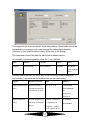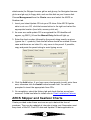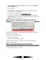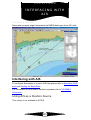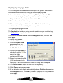
1
Navmaster User Gui de
NAVMASTER®
User Guide
Brunswick House, Brunswick Road, Plymouth PL4 0NP, UK
Tel: +44 (0)1752 254205
Email: [email protected]
Fax: +44 (0)1752 253599
Website: www.pcmaritime.co.uk
© PC Maritime 2009
Information You Need To Note
Use this page to note down your ARCS PIN and User Permit numbers. The PIN is a
4-digit number, eg 1234, found on the sheet headed Important Documentation
inside your Navmaster package.
Make a note here of your ARCS Licence number, eg 12345A, found on the UK
Hydrographic Office sheet headed “Schedule A” delivered with your first batch of
ARCS charts. You’ll need to quote this number when you buy more ARCS charts.
Please also remember to take good care of your security key (sometimes called a
dongle), which protects the copyright chart data against illegal copying. As a licensed
ARCS developer, PC Maritime is not permitted to issue replacement security keys
without charge for the full replacement value of software and charts. Make sure that
your security key is fully insured against risk of theft or loss.
My ARCS PIN number is:
____
My ARCS Licence Number is:
________
My ARCS User Permit is:
____ ____ ____ ____
My C-Map eToken # is:
________
(if you are operating a multi-user licence,
________
note the eToken # for each workstation
________
here)
________
________
Navmaster Version Information
Software
Navmaster ECDIS v7.0.0.X
C-Map SDK v4.2.1.18 with IHO
Presentation Library v3.4.0.0
ENC security
S-63 IHO Data Protection Scheme
Edition 1.1
Environmental models
Proudman Oceanographic
Laboratory Hydrodynamic Model
version 1.22
Magnetic Variation
IGRF-10 geomagnetic field model
(valid to 31 December 2009)
Operating System
Windows XP Professional Version
2002 including Service Pack 2
Microsoft MFC V8.00
Stingray Objective Toolkit v10.00
Crystal Reports v9.0 Print Engine
v9.0
Aladdin HASP4 8.0.1.0
The IHO Standards that relate to Navmaster ECDIS are listed below:
IHO ECDIS Standards
Current Edition
ECDIS Display and Presentation
S-52 PresLib Edition 3.4
Electronic Navigational Chart (ENC) S-57 Edition 3.1,
S-57 Edition 3.1.1 and S-57
Maintenance Document (Cumulative)
Number 8
Raster Navigational Chart (RNC)
S-61 Edition 1.0
ENC Data Protection
S-63 Edition 1.1
IHO Test Data Sets for ECDIS
S-64 Edition 1.0
Navmaster Setup Record
Vessel
Name
Dimensions (Vessel \
Setup \ General)
Length
m
Beam
m
Conning Position
Offsets
Length
m
Beam
m
Primary Position Fixing
System Offsets
Length
m
Beam
m
Secondary Position
Fixing System Offsets
Length
m
Beam
m
ARPA Offset
Length
m
Beam
m
Length
m
Beam
m
AIS Offset
COM port settings
(Navigator\Setup)
Checked
Com port no
Primary position fixing
system
transmit
COM
Secondary position
fixing system
COM
Gyro
COM
Speed
COM
Depth
COM
Wind
COM
(Target \ AIS \ Setup \
Configuration)
AIS
transmit
COM
COM
(Target \ ARPA \ Setup \
Configuration)
ARPA
COM
Monitor
Setup and calibration
COM
Baud rate settings
(Tools \ Setup \ Port
Settings)
ARCS Licence #
COM
Baud rate
COM
baud
COM
baud
COM
baud
COM
baud
ARCS Pin #
CONTENTS
Contents
NAVMASTER USER GUIDE
1
Information You Need To Note
2
Navmaster Version Information
2
Navmaster Setup Record
4
CONTENTS
WELCOME TO NAVMASTER
5
11
Chart Formats Supported By Navmaster
12
About This Guide
12
User Guide Conventions
13
INSTALLATION AND SETUP
15
Workspace
15
Installing Customised Passage Plans
16
Installing Proudman Tidal Areas
16
Setup Mode
16
Recording Screen Size
18
ECDIS Monitor Calibration
18
ECDIS Backup configuration
19
Setting a Consistent Common Reference Point (CCRP)
20
How to Enter Vessel Data
21
Setting Up the Interface to Instruments
22
NMEA Warnings and Alarms
25
NMEA Sentences
26
Alarm Management
32
Remote Diagnostics
32
Command Line Parameters
34
GETTING STARTED
36
Starting Navmaster.
36
Working With Windows Dialog Boxes
36
Property Inspection
36
The Navmaster Window
37
What’s In the Main Window?
38
Toolbars
39
Side Panels
42
Getting Help
49
To Close Navmaster
49
OPERATING NAVMASTER
50
How to Use Navmaster
50
How Navmaster Handles Time
50
Windows in Navmaster
50
Opening Electronic Charts
51
Navmaster Databases
51
Importing and Exporting Routes and Waypoints
53
Backing up Chartpoint, Route and Log databases
58
Using the Recent File List
61
To Change the Folder Location for Charts and Databases
61
To Open A Database from another Location
62
To Save A Database to A New Location
63
Maintaining Databases
64
Print and Print Preview
64
INSTALLING ARCS AND UPDATES
68
ARCS Licence Number
68
Chart Permits
68
To Delete All Charts
68
Installing ARCS or Seafarer Charts
68
ARCS Navigator or Seafarer Update Service
71
ARCS Skipper and Seafarer Charts
74
ARCS \ Seafarer Chart or Update Installation Failures
80
ARCS \ Seafarer Chart Management Information
81
INSTALLING AND UPDATING ENCS
83
Installing Encrypted ENC Charts
83
Installing Encrypted ENC Updates
87
To Update an Existing Licence or Add New Cell Permits
87
To Install ENC (S-57) Compiler License
88
Installing Unencrypted ENC Charts and Updates
90
Installing CM-ENC Charts
91
Installing CM-ENC Updates
95
ENC Chart or Update Installation Failures
97
ENC Chart Management Information
97
The C-Map Cartographic Service
98
INSTALLING C-MAP CM93/3 CHARTS AND UPDATES
102
Installing CM-93/3 Charts
102
CM-93/3 Chart Management Information
109
The C-Map Cartographic Service
110
ELECTRONIC CHARTS
113
ECDIS Chart 1
113
Scalebar, North Up Symbol And Scale Factor
114
Chart Options
115
Chart Setup
117
Selecting Charts
119
Safety Contours
120
Vector Chart Options
123
Presentation Parameters
123
Zooming Charts
126
Moving Around Charts
127
The Right Mouse Menu on Charts
127
Other Chart Commands
128
Manual Chart Updates
129
The Chart Information Panel
135
Chart Information on the Title Bar
138
Chart Notes and Diagrams (ARCS)
138
Temporary and Preliminary Notices to Mariners (ARCS)
139
The Blank Chart
139
CHARTPOINTS
140
Creating and Editing Chartpoints
140
Selecting a Chartpoint
141
GoTo Chartpoint
141
To Move A Chartpoint
142
To Delete A Chartpoint
142
To Sort Chartpoints
142
The Chartpoint Panel
142
Chartpoint Options
144
Chartpoint Setup
144
Entering Chartpoints in the Local Chart Datum
145
The Application of Datum Shifts to Chartpoints
146
ROUTES
148
To Create A Route
148
Setting Route Parameters
150
Editing A Route
152
Reviewing A Route
154
Route Functions
155
Route Side Panel Tabs
155
Route Warnings
158
Using Critical Points in Route Planning
159
Automatic Route Transfer to Backup ECDIS
160
Saving Your Work
161
Route Locking
161
Multiple Route Display
161
Route Options
163
Route Setup
168
The Application of Datum Shifts to Route Waypoints
168
PASSAGE PLANS
170
How to Create a Passage Plan
170
The Plan Tab
171
Printing and Exporting Plans
172
POSITION PLOTTING AND MONITORING
174
Interfacing to GPS
174
Starting a Passage
175
The Position Monitoring Side Panel
176
Route Locking
181
The Position Monitoring Window
182
Position Source
184
Position Offset
184
Navigator Options
185
Navigator Setup
186
Radar Overlay
191
Dead Reckoning (DR)
192
Position Logging
194
Log Reports
197
Uploading Routes and Waypoints to GPS
199
Tip - Using Position Monitoring With a “Look Ahead” Window
202
INTERFACING WITH AIS
203
Interfacing with AIS
203
AIS Data Categories
204
AIS Symbology
205
The AIS Toolbar
211
The AIS Target Tracking Side Panel
212
Changing Individual AIS Target Properties
215
AIS Options
216
AIS Setup
219
INTERFACING WITH ARPA
221
ARPA Target Symbols
221
Interfacing to ARPA
222
The ARPA Toolbar
222
The Target Tracking Side Panel
223
Changing Individual ARPA Target Properties
223
ARPA Options
224
ARPA Setup
225
NAVIGATION TOOLS
226
TotalTide Interface
226
Tidal Stream Atlas
230
Range and Bearing Tool (R&B)
234
Voyage Data Recording
237
Mariner Overlays
244
Mariner Tools
253
Datum Transformations
266
Calculator
266
On Screen Keyboard
267
Magnetic Variation Calculator
267
VESSEL
Own Ship Symbols
268
268
Vessel Options
272
Vessel Setup
276
CUSTOMISATION
Configuration Setup
NAVMASTER SHORTCUTS
Shortcut Keys
ACCURACY – GEODETIC DATUMS AND GPS
277
277
280
280
283
Background to Geodetic Datums
283
GPS Errors and Datum Considerations
284
Datum Management
285
Summary
286
WARNINGS
287
Alarms
287
Indications
288
System Messages
291
HCRF (ARCS & Seafarer) Error and Warning Messages
292
GLOSSARY OF TERMS AND SYSTEMS
296
Navigation System Types
299
TROUBLESHOOTING FLOW CHARTS
301
Interfacing with equipment
301
Chart installation
301
Interfacing to the AIS Pilot Plug
302
Navmaster Pilot Setup
302
WELCOME TO
NAVMASTER
Wel come To Navmaster
Navmaster is an advanced Electronic
Chart Display and Information System
(ECDIS). Its core function is to provide a
continuous display of vessel position
plotted onto official electronic charts.
The minimum input required for ECDIS
operation is position, heading and speed
log,
Navmaster manages all your navigation
data simply and effectively, storing them
in databases for you to use again. Its
passage-planning features are
unmatched by any other system.
And above all, Navmaster has a simple,
logical user interface which will be
familiar to anyone who has used a
Windows software program.
11
INTRODUCTION
Introducti on
Chart Formats Supported By Navmaster
Navmaster supports two raster chart formats:
• ARCS - a Raster Nautical Chart (RNC) produced by the UK
Hydrographic Office.
• Seafarer - a Raster Nautical Chart (RNC) produced by the
Hydrographic Service, Royal Australian Navy.
The two chart types are identical in format and the procedures for installing
and using them are the same.
Navmaster supports three vector chart formats
• ENCs – the official vector chart format required for ECDIS
• CM-ENCs – official vector charts in SENC format
• CM-93/3 - a private vector chart produced by C-Map Norway in the
same format as ENC.
All your charts are grouped to work together almost seamlessly. In effect,
the smallest scale chart (covering the largest area) acts as a "Master"
chart and more detailed charts as sub-charts.
About This Guide
This user guide assumes that:
• You have a working knowledge of navigation and are capable of
producing a safe navigation plan using traditional methods.
• You understand and can use the Windows XP operating system.
12
User Guide Conventions
Mouse operations
Click
Press and release the primary mouse button. The
primary mouse button is the button you use most often.
For most people, this is the left mouse button.
Right-click
Press and release the secondary mouse button. The
secondary mouse button is the button you use least
often. For most people, this is the right mouse button.
Double-click
Press and release the primary mouse button twice.
Drag
Move the mouse while you hold down the primary
mouse button.
Release
Remove your finger from a mouse button.
Scroll
Scroll bars along the right and bottom sides of a view
move the view up and down and left and right within the
window. To use a scrollbar, either click and hold one of
the arrow buttons or drag the scroll bar slider.
Keyboard
Tab
Press the <Tab> key to move from one box to the next.
<X>
Indicates a letter or word on the keyboard. Using the
keyboard to carry out commands often involves
pressing keys together or in succession.
<Ctrl> + <A>
(Or any two keys joined by a plus sign) Press and hold
down the <Ctrl> key followed by the <A> key.
Terminology
Cancel button
Click this button in a dialogue box to close the box
without applying the settings.
Check box
Click it to turn an option on and off. When the option is
selected, the box contains a check mark; when the
option is not selected, the box is blank.
Slider
Drag the slider to move along a range of settings. With
13
most sliders, moving to the left or down reduces an
effect or value; moving to the right or up increases it.
Spin control
The buttons with upward and downward pointing arrows
at the right hand side of number boxes. Press and hold
a button to increase or decrease a number rapidly.
Windows Controls
For ease of use, particularly at sea, spin-type
controls are automatically expanded when you
hover your mouse over them.
14
INSTALLATION
AND SETUP
Install ati on and Setup
Workspace
The Workspace is where setup information (eg com ports, vessel
dimensions) and options for Navmaster are stored. It is automatically
updated when you exit Navmaster.
Choose Workspace from the
File menu and select Save to
update your Workspace after,
for example, installation or
when new settings have been
applied. At this point you can
enter a comment to identify
the circumstances under
which the Workspace was updated.
Workspace Restore and Maintenance.
Workspace Maintenance allows you to restore Navmaster settings to a
previously saved Workspace with the settings saved at that time. This is
useful if, for example, your settings have become corrupted or have been
changed in error and you want to go back to the settings previously
applicable. To do this:
1. log into Setup Mode and choose Workspace \ Maintenance from the
File menu.
2. Dates when workspaces were saved will be outlined by a red box.
Select the date and the workspace you want to restore from the list to
the right and click Restore.
15
3. Select any unwanted saved Workspaces and click Delete to remove
them.
Installing Customised Passage Plans
Some customers have customised passage plan reports. Each report is
protected by a code number, which you will find on your PC Maritime CD.
1. Run the PC Maritime CD and click on the Applications button
2. On the next screen click the button marked Passage Plan Reports and
a list of company names will appear
3. Click on your company name to start the installation process
4. Enter the access code to install the customised report files.
Installing Proudman Tidal Areas
To install one or more Proudman tidal areas:
1. Insert the PC Maritime CD into your CD-ROM drive.
2. Click on the Programs button.
3. Click on the Proudman Tidal Stream button.
4. Select the area(s) you have purchased, enter the installation code
found on the PC Maritime CD and click Install.
Setup Mode
Variable parameters are placed under each main menu, divided between
Setup for parameters that are set during installation and infrequently
16
changed and Options for parameters that are changed during normal
operation.
Setup menus are unavailable during normal operation to prevent
accidental or unauthorised access. You must enter a password to gain
access. The password is case sensitive and must consist of at least 5
characters.
The default password is Navmaster
To Enter Setup Mode
1. Choose Setup from the File menu and select Log in
2. Enter the password and click OK
3. A message is displayed
momentarily to indicate whether
the password has been accepted
or rejected.
After the password has been accepted Setup and Chart Management
menus become available.
To Exit Setup Mode
Choose Setup from the File menu and select Log Out.
To Change Password
1. Choose Setup from the File
menu and select Change
Password.
2. Enter and confirm the new
password and click OK.
If you have forgotten your password …
Delete Support.sys from C:\Program Files \ Navmaster (only exists if the
default password has been changed).
17
Recording Screen Size
For symbols to be drawn at their correct size the size of your display must
be correctly entered.
Choose Setup from the Tools menu and select the System tab. Enter
height and width in millimetres. Save your Workspace.
Navmaster will display a message “Warning, workspace unsaved (screen
size may not be set)” until this action has been carried out.
If you are using a calibrated display (see next section) the screen size is
automatically applied and cannot be changed by the user.
ECDIS Monitor Calibration
ECDIS flat panel displays are calibrated against the PC’s graphics card so
that day, dusk and night colours conform exactly to those required by the
IHO ECDIS Presentation Library Edition.
The calibration takes place over a serial link between the computer and the
flat panel display and is applied automatically when shifting between day,
dusk and night palettes.
The following dialog is only visible if initialisation files are installed for the
monitor in question (ColourControl subdirectory and associated files).
When the appropriate calibration files are present, choose Setup from the
Tools menu and select the Monitor tab to set the following.
18
•
Control Port to select the com port used for the calibration
•
Connection Status shows whether the connection is active. Click Test
for visual confirmation that the connection is working (the backlight
values are changed momentarily).
•
Backlight modification to adjust the day, dusk and night backlight.
The default values are established during calibration and should not be
changed unless, due to the age of the monitor, the backlight is not
performing at its initial intensity. Click Set Default to set each value
back to its default.
Note: Be aware that use of a brightness or contrast control may
inhibit visibility of information, particularly when using the night
colour tables.
Calibration Screens provide a set of screens for colour tests.
ECDIS Backup configuration
Where dual Navmaster ECDIS systems are in operation with one system
configured as Primary and the other as Backup any changes saved to the
Primary system’s route database are automatically transferred to the
backup ECDIS if Auto transfer database on save is activated in Route \
Setup.
This requires a Command Line Parameter in the Navmaster icon which
must be configured as follows:
1. Close Navmaster.
2. On the Windows Desktop, right click on the Navmaster Icon, select
Properties and then the Shortcut tab.
3. Place your cursor at the end of the target field (after the quote mark),
enter a space and type DedicatedECDIS. If more than one Command
Line Parameter is present, separate each one with a space.
4. Click OK to close the dialog and restart Navmaster.
Once a network cable is connected (RJ45 - If two units are connected
directly, a crossover cable is necessary), the system will auto configure
19
and choose the unit with the lowest IP address as the Primary system. For
example:
IP address 192.168.0.1
will be the Primary system
IP address 192.168.0.2
will be the Backup system
To override auto assignment, the following Command Line Parameter can
be added to the Navmaster Icon target field to force a unit to Primary:
Primary
To force a system to be the primary ECDIS
Should there be a lot of PCs connected to a network the following
parameter will restrict the search to a range of IP addresses.
IPRange:xxx.xxx.xxx,x,x
Where xxx.xxx.xxx defines the first 3 segments of the IP
address to search for, and ,x,x defines the range to search
within, eg 192.168.0,1,5 would search for addresses in the
range 192.168.0.1 to 5. Note the placement of commas and
full stops; they are critical for this command line to work.
Setting a Consistent Common Reference
Point (CCRP)
A CCRP is defined as “a location on own ship, to which all horizontal
measurements such as target range, bearing, relative course, relative
speed, closest point of approach (CPA) or time to closest point of
approach (TCPA) are referenced, typically the conning position of the
bridge.”
In Navmaster the CCRP is the conning position which is set as described
under How to enter vessel data below.
The following items are drawn at the CCRP:
• own ship symbol and past track
• own ship’s heading line and velocity vector
• tracked target symbols and range and bearing to AIS target symbols
(AIS targets are plotted at the given latitude and longitude)
• the radar image overlay
• range and bearing, vessel to cursor
• ship-centred VRMs, EBLs and PIXs
• MOB R&B
20
How to Enter Vessel Data
Vessel dimensions and antenna positions
Log into Setup Mode and choose Setup \ General from the Vessel menu
to:
• Enter the vessel’s name. This is included on passage plan reports.
• Enter length and beam. This is used to draw a scaled outline of your
vessel. Gyro or compass input is required for the vessel outline to be
drawn.
• Set the conning position location and the antenna location for the
primary and secondary position fixing systems and ARPA.
Note: Failure to set these parameters correctly will cause the Own
Vessel scaled outline to be drawn incorrectly and for AIS, ARPA targets
and other range and bearing measurements to be inaccurately placed
relative to own ship.
TO ENTER SHIP’S DIMENSIONS
1. Enter Length and Beam.
2. Click Apply after each entry.
21
TO ENTER CONNING POSITION AND LOCATION OF ANTENNAS
1. Select the item to change from the drop down list.
2. In the Length field, enter a positive number to set antenna position
forward from amidships, or a negative number to set antenna position
aft from amidships.
3. In the Beam field, enter a positive number to set antenna position to
starboard of the centreline or negative to set antenna position to port of
the centreline.
4. Click Apply after each entry.
Note: it is only necessary to set the position of the AIS antenna if it is being
used as a position source.
Setting Up the Interface to Instruments
Please note that all equipment supplied with Navmaster ECDIS conforms
to International Standard IEC60945 for Maritime navigation and
radiocommunication equipment and systems. Only interface cards and
other equipment that have been approved in accordance with IEC60945
may be used in connection with Navmaster ECDIS.
Allocating COM ports
Log into Setup Mode. To enable Navmaster to read data from each
instrument:
1. Determine the COM port number used by the instrument.
2. Choose the menu item listed in the table for each instrument type.
Instrument
Location of COM port setting
Primary position fixing system
Navigator \ Setup \ Position \ Primary tab \
Receive
Secondary position fixing system
Navigator \ Setup \ Position \ Secondary
tab \ Receive
22
Depth
Navigator \ Setup \ Depth \ Receive
Gyro
Navigator \ Setup \ Gyro \ Receive
Speed
Navigator \ Setup \ Speed \ Receive
Wind
Navigator \ Setup \ Wind \ Receive
AIS
Target \ Setup \ AIS \ General \
Configuration \ Receive
ARPA
Target \ Setup \ ARPA \ General \
Configuration \ Receive
3. Set the COM port used by
the instrument in the
Receive box and click OK.
4. If a new sentence is not
received after the valid duration interval set, the sentence is considered
invalid. Set Valid Duration for Sentences between 1 and 60 (default
15s) for sentences to be valid for a time that suits you.
5. If data, for example position which often arrives in several different
sentences, is not received after the Valid Duration interval set, it is
considered invalid. Set Valid Duration for Data between 1 and 30
(default 5s) for data to be valid for a time that suits you.
6. To upload to GPS or AIS, set the COM port in the Transmit box and
click OK. Normally this will be the same COM port used to receive data
from the instrument.
7. Save your settings - see
workspace.
Setting the Baud rate
Most instruments output data at 4800
baud, the standard NMEA rate. AIS
outputs data at a higher rate (38400
baud) and for this reason should
normally be allocated a separate COM
port (this may not apply if an external
data combiner is used for all
instruments).
To set baud rate for any COM port:
23
1. Choose Setup from the Tools menu and select the COM port from the
drop down list.
2. Change the baud rate to the required level
3. Click OK.
4. Save your settings - see Workspace.
To verify data input
Once an instrument is connected, the COM port allocated and the baud
rate set, check data input as follows.
1. Choose NMEA Window from the Navigator menu, select the COM
port you wish to view, and click Receive to view data received or
Transmit to view data transmitted. Repeat if you wish to view more
than one COM port at a time.
2. If you open more than one NMEA window, choose Tile vertically or
horizontally from the Window menu so that you can identify the
instruments allocated to each COM port and view the data streams.
24
3. When data is streaming in, you can freeze the display by dragging the
vertical slide bar on the right hand side of the window upwards. You can
then verify that the required NMEA sentences are being received from
each instrument.
NMEA Warnings and Alarms
Checks are carried out on every NMEA sentence for:
1. Checksum: to detect if the data has been altered or corrupted during
transmission. The NMEA standard requires that a checksum is sent
with every sentence however sentences that are sent without a
checksum will be accepted provided that there are no other validity
issues.
2. Status flags: which are provided by some but not all sentences. For
example the status of the GLL sentence (Latitude and Longitude) is set
to invalid if its mode indicator is DR or Simulator. To allow for
circumstances where you might wish to use data sent with an invalid
flag, this check can be temporarily deactivated – see Ignore Warning
Flags below.
3. Invalid or null data or incorrect data in the context of the sentence.
To assist troubleshooting, appropriate messages are posted to the
Navigation section of System Messages. Where possible, the source of
the message is shown together with the state that has caused the
message or alarm.
25
If an Alarm is generated, such as for loss of position, then the following
window will appear. The alarm will sound until acknowledged.
NMEA Sentences
Note: the minimum inputs required for ECDIS mode are position, gyro
heading, and speed log.
Choose Setup from the Navigator menu, select the NMEA tab and then
Sentences. Select a device from the drop down list at the top of the dialog
to show the Talker ID and Sentences used by the device.
26
NMEA Talker ID
The Talker ID is a prefix attached to all NMEA sentences to identify its
origin. In the sample below, HE is Gyro (north seeking), RA is radar and
GP is GPS.
The standard Talker IDs are included in the receive list for each device
and are listed below. Any data not prefixed by one of the talker IDs in each
device’s list is ignored. However there are circumstances where NMEA
data that you wish to use is prefixed by a non-standard Talker ID.
To add a Talker ID for any device:
1. Select the device for
which you wish to
add a Talker ID from
the drop down list.
2. Click the New button
to the right of Receive
3. A text entry box appears. Enter the new Talker ID (eg RA under
Gyro).
4. Click OK or Apply and save your Workspace.
To remove a Talker ID, select it and click the Delete button.
To set the list of Talker IDs back to the original set, click the Default
button.
By default any data sent by Navmaster as a talker is prefixed with EI, the
Talker ID for ECDIS. To change, enter an appropriate ID in the Transmit
field, click OK or Apply and save your Workspace.
27
NMEA Sentence list
For each device, a list of
applicable sentences is
provided. Tick or clear the
box alongside any
sentence to activate \
deactivate.
Click the Tick button to activate all sentences or the Cross button to
deactivate all sentences.
Tick Ignore warning flags to ignore any warnings generated by a
sentence. Note: this setting is provided to overcome a short-term situation
or problem and is not saved to the workspace.
The following lists the NMEA sentences supported by Navmaster with
default Talker IDs for each device. Sentences prefixed with an asterisk are
required for normal operation.
AIS NMEA sentences
Pref’d
Sentence
Description
ALR: Set alarm state
Local alarm condition and status
VDM: UAIS VHF data link message
AIS target data
∗
VDO: UAIS VHF data link own
vessel report
Data relating to own vessel. Can be
used instead of GPS for position
source.
∗
VSD: UAIS Voyage static data
∗
∗
Used to send information about a
vessel’s transit that remains
relatively static during a voyage
Output
AIS TALKER IDS
Receive
AI
Transmit
EI
ARPA NMEA sentences
Pref’d
Sentence
Description
OSD: Own Ship Data
Heading, course, speed, set and drift
summary. Can be used as source for
heading data by adding the radar
Talker ID to the list recognised by
28
Gyro – see NMEA Talker IDs
∗
TLB: Target Label
Common target labels for tracked
targets.
TLL: Target Latitude and
Longitude
Target number, name, position and
time tag.
TTM: Tracked Target Message
Data associated with a tracked target
relative to own ship’s position.
RSD: Radar System Data
Radar display setting data. Includes
range and bearing to radar cursor.
Either TLL or TTM (preferred) is required in order to display a target
position. RSD enables the radar cursor to be superimposed on the chart.
ARPA TALKER IDS
Receive
RA
Transmit
none
Depth NMEA sentences
Pref’d
∗
Sentence
Description
DBT: Depth Below Transducer
Water depth referenced to the
transducer
DPT – Depth
Water depth relative to the
transducer and offset of the
measuring transducer
DEPTH TALKER IDS
Receive
SD, II
Transmit
None
Gyro NMEA sentences
Pref’d
Sentence
Description
HDG Heading – Deviation &
Variation
Heading (magnetic sensor reading),
which if corrected for deviation, will
produce Magnetic heading, which if
offset by variation will produce True
heading.
HDM: Heading – Magnetic
Actual vessel heading in degrees
Magnetic (if this sentence is the only
source of heading available,
Navmaster will derive a true heading
by adding variation from the IGRF
model – see
http://www.ngdc.noaa.gov/IAGA/vmo
d/igrfhw.html for the limitations of this
model)
29
∗
HDT: Heading – True
Actual vessel heading in degrees
True produced by any device or
system producing true heading.
∗
THS: True Heading and Status
Actual vessel heading in degrees
True produced by any device or
system producing true heading.
VHW: Water Speed and Heading
The compass heading to which the
vessel points and the speed of the
vessel relative to the water.
OSD: Own Ship Data
Heading, course, speed, set and drift
summary from ARPA.
(via
ARPA)
GYRO TALKER IDS
Receive
HC, HN, VD, HE, II, VM Transmit
None
Primary and Secondary Position Systems (normally
GPS) NMEA Sentences
Pref’d
Sentence
Description
BOD: Bearing – Origin to
Destination
Bearing angle of the line, calculated
at the origin waypoint, extending to
the destination waypoint from the
origin waypoint for the active
navigation leg of the journey.
BWR: Bearing and Distance to
Waypoint
Time (UTC) and distance and
bearing (rhumb line) to, and location
of, a specified waypoint from present
position.
DTM: Datum Reference
Local geodetic datum and datum
offsets from a reference datum.
GGA: Global Positioning System
Fix Data.
Time, position and fix related data for
a GPS receiver
∗
GNS: GNSS Fix Data
Fix data for single or combined
satellite navigation systems (GPS,
GLONASS, GNSS)
∗
GLL: Geographic Position –
Latitude/Longitude
Latitude and Longitude of vessel
position, time of position fix and
status
GLP: Loran-C Position
Present position and time
RMA: Recommended Minimum
Specific Loran-C data
Position course and speed data
provided by a Loran-C receiver
RMB: Recommended Minimum
Navigation Information
Navigation data from present
position to a destination waypoint
provided by Loran-C, GNSS,
navigation computer or other
integrated navigation system
∗
30
∗
Time, date, position, course and
speed data provided by a GNSS
navigation receiver.
RMC: Recommended Minimum
Specific GNSS Data
Output
Waypoint identifiers, listed in order
with starting waypoint first, for the
identified route
VTG: Course Over Ground and
Ground Speed
The actual course and speed relative
to the ground.
WPL: Waypoint Location
Latitude and Longitude of a specified
waypoint
RTE: Routes
Input and Output
XTE: Cross-Track Error –
Measured
Magnitude of the position error
perpendicular to the intended track
line and the direction to steer to
return to the intended track.
ZDA
UTC, day, month, year and local
time zone
Time and Date
ZTG: UTC & Time to Destination
Waypoint
UTC and predicted time to go to
destination waypoint
GPS TALKER IDS
Receive
GN, GL, GP, II
Transmit
None
Speed NMEA sentences
Pref’d
(via
ARPA)
Sentence
Description
VBW: Dual Ground/Water Speed
Water referenced and ground
referenced speed data
VHW: Water Speed and Heading
The compass heading to which the
vessel points and the speed of the
vessel relative to the water
OSD: Own Ship Data
Heading, course, speed, set and drift
summary from ARPA.
SPEED TALKER IDS
Receive
VD, VW, SN, VM, II
Transmit None
Wind NMEA sentences
Pref’d
Sentence
Description
MWD: Wind Direction & Speed
The direction from which the wind
blow’s, with respect to north, and the
speed of the wind
MWV: Wind Speed and Angle
Apparent or true
31
WIND TALKER IDS
Receive
WI, II
Transmit
None
Alarm Management
ARPA and AIS Target Alarms
Choose Setup from the Target menu and select the Alarm tab for an
alarm to sound for AIS or ARPA targets based on:
• Target Range
• CPA \ TCPA
Uncheck these options if you do not want an alarm to sound.
Remote Diagnostics
Remote Diagnostics is a service available to customers with Technical
Support Contracts. If you wish to take advantage of this service and do not
have a Technical Support Contract please contact PC Maritime.
Navmaster stores user configurations in a workspace, which is stored in
the Windows Registry. Workspaces can be emailed to PC Maritime to
enable us to replicate your system settings for technical support.
If you are having difficulty establishing correct connection with marine
instruments (GPS, Gyro, ARPA etc) you can record the data being
received. By emailing a file to PC Maritime we can replay the data received
from your equipment and help you identify and correct any problems.
32
To Email Your Workspace To PC Maritime.
1. From Navmaster choose Workspace from the File menu ,click Export
and choose the destination folder.
2. This will save a file called Registry x.txt (where x is a number
incremented by 1 every time you export).
3. Email Registry x.txt to your contact at PC Maritime or
[email protected].
To Email A NMEA Data File To PC Maritime.
Log into Setup Mode.
1. From Navmaster
choose Setup from
the Navigator menu
and select the
NMEA tab.
2. Click the browse
button to the right of
the Export file field.
3. This opens a
standard dialog as shown below
a. Select a location for the file (we suggest My Documents for
ease of access).
b. Type a file name (we suggest your name or the name of your
vessel followed by Data Test).
33
c. Click Open.
4. Check the Process check box and click Apply.
5. Allow five or ten minutes for sufficient data to be captured and then
uncheck the Process box.
6. Email the data file with C:\My Documents\Registry x.txt to your
contact at PC Maritime or to [email protected]
Note: You may wish to zip the files up before emailing. This will reduce
their size substantially.
Command Line Parameters
Navmaster can accept a number of command line parameters for special
situations. Using these parameters you can specify, for example, a specific
com port to search for or error logging for troubleshooting.
To apply a Command Line
Parameter.
1. Close Navmaster.
2. On the Windows Desktop,
right click on the Navmaster
Icon, select Properties and
then the Shortcut tab.
3. Place your cursor at the end
of the Target field (after the
34
quote mark and any existing command line entries), enter a space and
type the command line (eg logerrors as shown above). To add more
than one Command Line Parameter, separate each one with a space.
4. Click OK to close the dialog and restart Navmaster.
Ascertain whether applying a command line has resolved the problem and
contact PC Maritime for further support if necessary. When you are
finished, close Navmaster and remove the command line from the end of
the Target field if appropriate.
The following Command Line Parameters are available:
AddComPort
For use where Navmaster does not automatically recognise a
com port. Use this parameter followed by a colon and space with
the com port numbers you wish to be recognised. For example:
addcomport: 6,7,8
Clean
Removes any temporary files left over after a system crash.
Remove on completion.
DedicatedECDIS
Enables automatic route transfer between connected ECDIS
DongleUpdate
Use this parameter, followed by the update string to apply
changes to the Navmaster ECDIS dongle, which does not have
the option to update dongles from the Help menu, or for other
versions where the dongle has expired.
Eg DongleUpdate:204F64EE930177
Remove on completion.
Logerrors
Generates a file, Errorlog.txt, located in C:\Program
Files\Navmaster containing error reporting. Normally only used
under the instructions of PC Maritime’s technical support team.
Noworkspace
This parameter forces Navmaster to start with default settings.
IgnoreCMapCompile
Errors
nototaltide
35
CHAP TE R
O NE
GETTING
STARTED
Getti ng Started
Starting Navmaster.
Navmaster automatically starts when the ECDIS is turned on.
Working With Windows Dialog Boxes
Dialog boxes contain tabs, areas, entry boxes, drop-down lists, and various
other types of check boxes and buttons. Dialog boxes containing large
numbers of options are often organised into tabbed areas, which are selected
by clicking the tab’s title to bring it forward.
After making selections in a dialog box, pressing the OK button causes the
changes to take effect after the dialog box closes. Nearly all dialog boxes
feature an Apply button that causes the changes to take effect before
exiting the dialog box. This way you can preview your changes before
actually committing to them. Clicking the Cancel button causes the dialog
box to disappear without any changes taking effect.
Property Inspection
Objects drawn on the chart have properties such as name or position. The
Properties command, which appears if you right click on the object on the
chart, lets you inspect those properties and, in some cases, configure the
object.
36
The Navmaster Window
When you start Navmaster the display will look similar to the one below.
Figure 1 Navmaster Window in Position Monitoring mode
When you are in Chartpoint, Route or Route Management mode, extra
toolbars are added as shown below.
Figure 2 Toolbar layout in Planning Mode
37
What’s In the Main Window?
Title Bar
The title bar displays the program control icon, the application or active
image title, and minimise, maximise and close buttons.
Menu Bar
The menu bar displays the menu headings.
File
Contains: standard menu commands for file management;
printing and workspace; importing and exporting route and
Chartpoint information; backup, opening charts; and
opening and saving Chartpoint and route databases.
Edit
Provides standard menu commands.
View
Provides menu commands to select modes of operation,
turn on or off the toolbars, side panel and status bar.
Chart
Provides menu commands to change the chart display,
install chart permits and updates, set the location of charts
and updates, GoTo a specified position, add and manage
manual chart updates and set chart related options.
Navigator
Provides menu commands to: set position source and DR
parameters; apply a position offset, GoTo vessel; set
position monitoring options; make log entries; access
diagnostic windows to display data inputs; upload routes
and waypoints to GPS, and set position and navigation
related options.
Target
Provides menu commands related to AIS and ARPA and
set related options.
Chartpoint
Provides menu commands related to Chartpoints.
Route
Provides menu commands related to Routes.
Vessel
Provides menu commands to enter vessel data and
38
manage vessel related alarms and warnings; a deviation
table; to set vessel related overlays and to set track related
parameters.
Tools
Provides menu commands to display tidal atlas; work with
Voyage Data Recording (if purchased); work with Mariner
Overlays; datum transformations, calculator, on-screen
keyboard and set workspace and tidal atlas options.
Window
Provides standard menu commands to manipulate
windows.
Help
Provides Help, access to the ECDIS symbol chart; online
updating and information on getting technical support.
Any menu items that are “greyed out” are either unavailable in the current
mode or not available in your version of Navmaster.
Status bar
The following information is permanently displayed on the Status Bar.
System messages
Click to review system messages. This area
flashes when a new message is received.
Toolbars
The toolbars provide buttons that access the frequently used commands in
the menus. If a command is unavailable, its button appears greyed-out.
Toolbars are laid out as shown in The Navmaster Window.
Standard Toolbar
39
Chart Toolbar
Manual Updates Toolbar
Display Toolbar
Voyage Toolbar
AIS Toolbar
40
ARPA Toolbar
Radar Overlay Toolbar
Mariner Overlays
Mariner Tools
Vector Chart Toolbar
41
Chartpoint Toolbar
Route Toolbar (selects the route for editing only)
The Chartpoint and route toolbars are only available in Chartpoint and
Route mode as shown in The Navmaster Window. They contain scroll
buttons to enable you to select the first, previous, next, or last item in the
database or route.
The camera buttons allow you to view any pictures you have attached to
the Chartpoint or route.
You can select a Chartpoint, route or route waypoint by name by clicking
on the down arrow to the right of the Chartpoint or route name box.
Side Panels
Each of Navmaster’s main functional areas: monitoring position, storing
Chartpoints, and creating and calculating routes, has a side panel. You
switch between each function by pressing a button on the display toolbar
or by pressing the F12 key.
The side panel can be toggled on or off by clicking
toolbar.
on the display
By default the side panel is docked at the edge of the window. It can also
be undocked and left “floating” anywhere on the display, to allow more
space for chart display.
42
To dock the side panel:
• Double-click the title bar of the floating side panel. It will either dock at
the last place it was docked or select a default location.
To undock, do one of the following:
• Double click on the “handle” at the top of the side panel.
• Click and hold the handle and drag to the desired location.
Position Monitoring Side Panel.
The Position Monitoring Side Panel repeats
position from your sensors, (GPS, speed
log and gyro) provides information on any
datum shift that has been applied and
displays the active route name, active leg
and ETA at the destination waypoint
calculated from current speed over ground
(SOG). Tabs provide further information:
•
NMEA: repeats information from
electronic instruments.
•
to Wpt: provides calculated information
from current position to the next
waypoint in the route.
•
ETD: provides a means of setting
departure time for passage plan
calculation and route annotation.
•
Wind: repeats information from wind
instruments.
•
Devices: displays the Primary position
source, Secondary position source (if
connected) and Dead reckoning. A
green dot indicates the positioning systems that are active. The
difference between positions (in metres) is shown.
•
Satellite: repeats information on the quality and status of GPS
satellites (if the NMEA GGA sentence is received).
43
•
Route Warnings: displays a list of warnings generated against the
monitored route.
•
Chart Warnings: displays a list of warnings generated against
monitored position.
You can select the active route from the drop down list to the right of the
route name box. The Lock check box activates or deactivates route
locking so that route legs automatically increment as you pass waypoints.
(Note: if the correct leg is not selected it may be because Lock was
checked before or during a period when position input became active. In
this event uncheck and recheck the Lock box and the correct leg will be
selected).
Chartpoint Side Panel
The Chartpoint side panel enables you to
add, delete or edit Chartpoints. Chartpoints
are stored in a database; you can create any
number of Chartpoint databases containing
any number of Chartpoints.
The panel provides information about the
current Chartpoint. Each field within the panel
can be edited.
44
Route Side Panel
The Route side panel enables you to create
new routes, edit existing routes and copy or
reverse routes. Routes are stored in a route
database; you can create any number of
route databases containing any number of
routes.
Five tabs provide further information:
General enables you to enter and display a
textual note relating to the route.
Waypoints lists the waypoints in the route
and provides a means to select waypoints
for amendment or deletion or to locate a
new waypoint. Plan gives the ability to
calculate a passage plan based on the
route that you can print or view on screen;
Warnings allows you to view any chart
generated warnings applicable to the
selected route and Charts lists the installed
charts that cover the route.
button displays a horizontal panel that enables you to enter
The
planned speed, off track limits and radius and rate of turn per leg and view
planned times and distances.
45
Route Management Side Panel
This side panel enables you to:
•
Select the active route
•
Select the route to edit
•
Select any route for multiple display
46
Target Tracking
This side panel provides information on
ARPA and AIS targets.
47
Information
This side panel provides information on the
selected chart, any cautions and access to
Temporary and Permanent Notices to
Mariners (ARCS), text notes, picture and
general files (ENCs & CM-93/3), and any
categories that are removed from the
Standard Display (ENCs & CM-93/3).
48
Getting Help
ToolTip and Status Bar
To see the name of a button on the toolbar, place the cursor over it. A
short description of the item also appears on the status bar.
Help
Choose Help Topics (includes Troubleshooting Flow Charts) from the
Help menu to access online help. If online help is unavailable, this User
Guide will open in Adobe Acrobat.
System Information
Choose System Information from the Help menu to view:
•
Operating system information including system resource usage and
memory availability.
•
Library information
•
Files in use to view the names of the open charts, Chartpoint, Route
and Log databases.
To Close Navmaster
Choose Exit from the File menu.
49
CHA PTE R
TW O
OPERATING
NAVMASTER
Operati ng Navmaster
How to Use Navmaster
The recommended sequence to follow when using Navmaster is:
1. Create a route
2. Calculate a plan
3. Monitor and plot your position
Each of these operations is fully described in later chapters.
How Navmaster Handles Time
Navmaster takes time from your operating system so it is important that
your computer clock and zonetime are set correctly. Although all times are
displayed in local time (eg in logs and in dialogs), internally Navmaster
converts times to GMT. This enables calculations from, for example, the
Proudman tidal model to be calculated correctly.
Windows in Navmaster
Navmaster is a multi-window application. Charts, the log, waypoint lists etc
all have their own window and can be tiled, cascaded or kept in the
background to suit the job in hand.
This gives you complete flexibility to organise your chart views to suit the
tasks in hand. For example you can open new chart windows for the
following:
• To look ahead by displaying the vessel position on a smaller scale chart
than the Position Monitoring chart.
• To view the approaches or harbour charts for your destination
• To plan new routes or Chartpoints
Whilst you are carrying out any of the above you can still view the Position
Monitoring window.
50
You can choose how chart windows are displayed from the Window menu.
They can be cascaded, tiled or individually sized.
You can toggle between each open window by pressing <CTRL>+<TAB>
or <CTRL>+<F6> or by selecting from the list of open windows at the foot
of the Window menu.
Opening Electronic Charts
When you start Navmaster, a Position Monitoring window is opened
automatically if position data is available. Otherwise the chart display area
is blank. Refer to Selecting Charts for further details.
Navmaster Databases
In Navmaster, databases are used to store Chartpoints, Routes and Logs. File
operation is very similar to any Windows application.
Note: A database contains any number of Chartpoints, routes or logs. You
do not need to “save” a new database every time you create a Chartpoint,
route or log. Normally you would only have additional databases if you
wanted to maintain your routes and Chartpoints in separate areas, eg, one
for the Caribbean, and another for the Mediterranean. We recommend that
you regularly back up Chartpoint and Route databases.
51
Managing databases
CREATING A NEW CHARTPOINT, ROUTE OR LOG DATABASE
1. Choose New from the File menu or click
dialogue box opens.
on the toolbar. The New
2. Select the Chartpoint, Route or Log tab and double click on the
Database symbol.
3. Type a name in the File name field and click Save.
SAVING A CHARTPOINT, ROUTE OR LOG DATABASE
Choose Save, Save as or Save all from the File menu. When you choose
Save, you must select Chartpoint, Route or Log as required. When you
choose Save all, all open databases will be saved.
52
Opening a database or replacing a chart in the
current window
To open an existing file:
1. Choose Open from the File menu or click
on the toolbar. Select the
Chart, Chartpoint, Route or Log symbol depending on the type of item
you wish to open.
2. Double click on any of the items listed.
3. An Open dialogue box will appear.
4. Select the file required from the Name column
5. Click Open. (A chart opened through this dialogue will replace the chart
in the current chart window.)
Importing and Exporting Routes and
Waypoints
Procedures are provided to import or export route and waypoint data from /
to comma separated value (csv) or text (txt) file formats.
53
To Import Waypoints into a Chartpoint database
1. If you wish to import waypoints into an existing Chartpoint database,
ensure it is open, otherwise create a new database (File \ New \
Chartpoint database).
2. Select the Chartpoint side panel and click the Edit button.
3. Choose Import from the File menu and click the Chartpoint icon.
4. Click the browse button to the right of File name and select the file to
be imported.
5. Click Import.
The waypoint list must include all fields listed above: blank fields should be
separated by commas (or you can change the default field delimiter
(comma) or text qualifier (quote mark) at the top of the dialog).
An example comma separated value file (*.csv) follows:
Name
ID
"LIZARD", "AN110",
Latitude
Longitude
Datum
Area
"49°54.9798'N",
"005°10.0098'W",
"WGS84", "UK
Group
Zone Memo
"WPT", 0.00,
WEST",
"England's
most
southerly
point."
Latitude and longitude can be in any of the following formats (degrees (°)
and minute (‘) symbols can be entered but are not necessary):
54
Degrees
Minutes / seconds
Sign
Example
degrees followed by a
decimal minutes or
N or S / E or W
"49°54.9798'N",
space
minutes and seconds
"005°10.0098'W",
separated by a space
OR
“49 54 30 N”
“5 25 30 W”
degrees followed by .
Decimal degrees to a
Latitude – positive for
(point)
maximum 15 decimal
N, negative for S
places
27.11666667,
-50.16666667
Longitude – positive
for E, negative for W
Use the standard codes (WGS84, ETRS89, ED50 etc) to identify the
datum of the position and ensure that the positions are correctly
referenced to the chart.
To Export Chartpoints to a file
1. To export Chartpoints, open the Chartpoint database you wish to
export.
2. Choose Export from the File menu and click the Chartpoint icon.
3. Click the browse button to the right of File name, select the location for
the file and enter a filename with the suffix txt or csv depending on the
file format required.
4. Click Export.
55
You can change the default field delimiter (comma) or text qualifier (quote
mark) at the top of the dialog.
To Import Waypoints into a Route database
1. If you wish to import waypoints into an existing Route database, ensure
it is open, otherwise create a new database (File \ New \ Route
database).
2. Select the Route side panel and click the Edit button followed by the
New button.
3. Choose Import from the File menu and click the Route icon.
4. Click the browse button to the right of File name and select the file to
be imported.
5. Click Import.
56
The waypoint list must include all fields listed above: blank fields should be
separated by commas (or you can change the default field delimiter
(comma) or text qualifier (quote mark) at the top of the dialog).
The maximum size of the data for each field is shown above.
An example comma separated value file (*.csv) follows:
Name
Latitude
Longitude
Datum
Memo
"LIZARD",
"49°54.9798'N",
"005°10.0098'W",
"WGS84",
"England's
most southerly
point."
Latitude and longitude can be in any of the following formats (degrees (°)
and minute (‘) symbols can be entered but are not necessary):
Degrees
Minutes / seconds
Sign
Example
degrees followed by a
decimal minutes or
N or S / E or W
"49°54.9798'N",
space
minutes and seconds
"005°10.0098'W",
separated by a space
OR
“49 54 30 N”
“5 25 30 W”
degrees followed by .
Decimal degrees to a
Latitude – positive for
(point)
maximum 15 decimal
N, negative for S
places
Longitude – positive
for E, negative for W
57
27.11666667,
-50.16666667
Use the standard codes (WGS84, ETRS89, ED50 etc) to identify the
datum of the position and ensure that the positions are correctly
referenced to the chart.
To Export Route Waypoints to a file
1. To export route waypoints, open a Route database and select the route
you wish to export.
2. Choose Export from the File menu and click the Route icon.
3. Click the browse button to the right of File name, select the location for
the file and enter a filename with the suffix txt or csv depending on the
file format required.
4. Click Export.
You can change the default field delimiter (comma) or text qualifier (quote
mark) at the top of the dialog.
To Import Waypoints from GPS or other NMEA
compatible device
The GPS or other device must be capable of exporting the waypoints
contained in its memory via the NMEA sentence WPL (Waypoint Location).
Please refer to your device’s documentation to determine how to do this.
WPL includes latitude, longitude and Identifier (name). It does not provide
any information about datum which is therefore assumed to be unknown.
58
1. To import waypoints into an existing Chartpoint database, ensure it is
open, otherwise create a new database (File \ New \ Chartpoint
database).
2. Select the Chartpoint side panel and click the Edit button.
3. Choose Import from the File menu and select the NMEA tab.
4. Select the correct Com port from the Receive drop down list.
5. Click Receive whereupon each waypoint will be added to the list in the
dialog.
6. Once you have received all the waypoints click Receive again to
prevent further waypoints being added. Uncheck the tickbox for any
waypoints you do not wish to save.
59
7. You can now manually edit any of the fields, for example, datum as
shown below.
8. Once you have finished click Save to transfer the waypoints to the
currently open Chartpoint database.
Backing up Chartpoint, Route and Log
databases
This feature enables you to quickly copy data to backup media (USB
memory stick, another hard drive etc).
60
To carry out a backup:
1. Choose Backup from the File menu
2. Select the items you wish to backup from the list
3. Click the browse button to choose the destination location. The Backup
button is greyed out until a location other than C:\Program
Files\Navmaster is selected or if there is insufficient space on the
backup media.
4. Click Backup.
Using the Recent File List
The charts you have recently opened appear at the foot of the File menu.
Up to 4 charts can appear. To open one of these, double-click on its name.
To Change the Folder Location for Charts
and Databases
If you wish, you can change the folder location for charts and the
Navmaster databases as follows:
1. Log into Setup Mode
2. Choose Management from the Chart menu and select the General
tab.
3. Click the Chart folder browse button to change the folder location.
61
4. Click the External Chart Source to change the CD Drive from which
you will read chart CDs.
Logs
1. Log into Setup Mode and choose Setup from the Navigator menu and
select the General tab.
2. Click the Database folder browse button to change the folder location.
Chartpoints
1. Log into Setup Mode and choose Setup from the Chartpoint menu
and select the General tab.
2. Click the Database folder browse button to change the folder location.
3. Click the Attachments folder browse button to change the folder
location.
Routes
1. Log into Setup Mode and choose Setup from the Route menu and
select the General tab.
2. Click the Database folder browse button to change the folder location.
3. Click the Attachments folder browse button to change the folder
location.
To Open A Database from another Location
If you wish to open databases from another location, such as disk or backup locations:
1. Choose Open from the File menu, or click
on the toolbar.
2. Click the type of database you want to open.
3. Click on the browse button alongside the Look in path.
4. Select the new location.
5. Double click the file required.
6. Remember to change the Database Folder location back to the original.
62
To Save A Database to A New Location
Follow this process to back up databases or copy them to media for
transfer to another PC.
1. Choose Save As from the File menu, or click
on the toolbar.
2. Click the type of database you want to save.
3. Click on the browse button alongside the Look in path.
4. Select the new location.
5. Type a filename in the File name box.
6. Click Save
7. Remember to change the Database Folder location back to the original
if you do not wish to permanently save databases to the new location.
63
Maintaining Databases
These options are available from the Open, Save and Save as dialogs:
1. The Browse button, to change the location for opening and saving.
2. The Delete button to delete the selected file.
3. The Folder button to create a new folder.
4. The Tools menu which contains the following options:
a. Change Directory to select a new location for file operations.
b. Rename
c. Delete
d. Copy to create a copy of the selected file.
e. ReadOnly to add or remove a read-only flag to a database.
Navmaster will not operate correctly if a database is set to read-only.
Databases backed up to CD are invariably set to read-only. If you
copy them back to your hard disk use this option to turn off the readonly flag for each database.
f. Clean Temporary Files which will remove temporary files left over
from previous Navmaster sessions. The option is greyed out if there
are no temporary files to remove.
g. Refresh to redraw the file list.
Print and Print Preview
The following reports are available to print from Navmaster:
64
System Reports
Setup Record
A very useful report that lists com port allocations,
vessel dimensions etc. We recommend that you print
this report after installation or when you make and
changes to your setup.
Chart Reports
View of selected Prints the selected chart window.
chart
Installed chart
list
Provides a list of all charts installed with chart number,
description and scale.
Installed ARCS
list
Provides a list of all charts licensed with chart number,
description and scale plus the permit number and chart
and update CD dates applicable to each chart.
Chartpoint Reports
Chartpoint List
Provides a list of all Chartpoints in the current
Chartpoint database.
Route Reports
Waypoint list
Provides a list of the waypoints in the currently selected
65
route with distance and course for each leg.
Route list
Provides a list of all routes in the current database
showing Name, From and To fields.
Route list (full
details)
Provides a list of all routes in the current database
showing Name, From and To fields plus additional
information including the contents of the memo field for
each route.
Plan Reports
Passage plan
(with memos)
Provides leg information only
Passage plan
(without
memos)
Provides leg information plus any memos that have
been incorporated for waypoints.
Passage plan
Includes magnetic variation and deviation calculations
Log Reports
Vessel log
Limited report of positions, COG, SOG & notes
Voyage log
Full report to ECDIS requirements
Log list
List of all logs stored in the current log database
To view a report
1. Choose Print Preview from the File menu. Note that you must have a
printer driver installed.
2. Select the Chart, Chartpoint, Route or Log tab and double click the item
you wish to preview.
66
To print a report
1. To print a report, choose Print from the File menu or click
toolbar. Note that you must have a printer driver installed.
on the
2. Select the Chart, Chartpoint, Route or Log tab and double click the item
you wish to print.
67
CHA PTE R
TH REE
INSTALLING ARCS
AND UPDATES
Installi ng ARCS and Updates
The UK Hydrographic Office offers two update services for ARCS:
• The Navigator service where you licence charts for 12 months during
which you receive a weekly Update CD.
• The Skipper service where you buy charts without time limit, and can
buy updates annually or quarterly.
Seafarer is provided by the Australian Hydrographic Office in a similar
fashion except that all charts are licensed without time limit with options to
subscribe to a monthly or periodical update service.
ARCS Licence Number
With your first delivery of ARCS charts you received a UKHO sheet
headed “Schedule A” containing your ARCS licence number. To purchase
additional charts you must give your chart supplier this licence number.
Chart Permits
Each RC Chart CD contains all the charts available for a particular region.
A chart permit is a code that unlocks a specific chart.
To Delete All Charts
Click Delete to delete all charts related to the tab currently in view (ARCS,
ENC, Seafarer or CM93/3). This is useful should you need to reinstall
charts from a clean start.
Installing ARCS or Seafarer Charts
For your first installation of ARCS or Seafarer charts you need:
1. One floppy disk containing a licence file and chart permit file.
2. One (or more) RC chart CDs.
3. One Update CD containing the latest chart corrections.
68
Installing charts on a computer Installing charts
licences for the first time or when a new licence is
issued
1.
Start Navmaster
2.
Choose Management from the Charts menu
3.
Choose the ARCS or Seafarer tab
4.
Insert your Weekly Update CD in your CD drive. If the ARCS Update
data is not on a CD, click the browse button to the right and select the
appropriate location (hard disk, memory stick etc).
Note that the CD Identifier field and all other options will be greyed
out until a valid Update CD is inserted.
5. Once the Update CD has been recognised its CD identifier will be
displayed, and the Select Permits field will light up.
6.
Insert the Licence disk into the floppy disk drive.
7.
Click
8.
Select the location of the permits disk (normally drive A:).
9.
Double click the GB.* (ARCS permits) or AUS.* (Seafarer permits)
file.
at the end of the Select Permits field.
10. Click the Install button. The permits and updates will be installed.
69
11. Once the Update CD has been read you will be prompted to insert
each Area CD. If you want to skip an individual Area CD, click Cancel
alongside the insert CD message. Note: clicking Cancel at the
bottom of the dialog cancels the complete chart installation.
12. Insert the Area CD and / or Update CDs requested and click OK.
Repeat this operation until all Area CDs are installed.
Note: If the ARCS data is not on a CD, click the browse button to the
right and select the appropriate location (hard disk, memory stick etc).
13. On completion, select the History tab and check that no errors have
occurred. If data has failed to install refer to Chart Installation
Failures.
Note: Each ARCS/Seafarer chart takes about 1.5-2MB hard disk space.
70
Installing on a computer without a floppy disk drive
If your licence and chart permits are emailed or delivered on a floppy disk
and your computer does not have a floppy disk drive, copy the files to a
hard drive folder (X:\Permits) or other media (eg CD, or USB memory
stick) and access them from there.
ARCS Navigator or Seafarer Update Service
Charts provided under these services are issued with regular updates.
To install chart updates
The Update CD is cumulative and contains all the information on earlier
Update CDs plus the new week’s information. You only need to install the
latest weekly Update CD; all earlier Update CDs can be discarded.
1. Choose Management from the Chart menu and click the ARCS tab.
The dialog will show Insert Weekly Update CD until you put a CD into
the drive.
2. Insert your latest Update CD. Once recognised its identifier will be
displayed, eg WK10_04 and the Select Permits field will light up.
Note: If the ARCS data is not on a CD, click the browse button to the
right and select the appropriate location (hard disk, memory stick etc).
3. Click Install in the Updates Installation section.
4. On completion, select the History tab and check that no errors have
occurred. If data has failed to install refer to Chart Installation Failures.
71
To install additional charts from the licence disk
1. Start Navmaster.
2. Choose Management from the Charts menu.
3. Choose the ARCS or Seafarer tab as required.
4. The dialog will show Insert Weekly Update CD until you put a CD into
the drive.
Note: If the ARCS Update data is not on a CD, click the browse
button to the right and select the appropriate location (hard disk,
memory stick etc).
5. As soon as a valid update CD is recognised the message will disappear
and the CD identifier will appear, and the Select Permits field will light
up.
6. Insert the Licence disk into the floppy disk drive.
7. Click
at the end of the Select Permits field.
8. Select the location of the Permits disk, normally drive A.
9. Double click the GB.* (ARCS permits) or AUS.* (Seafarer permits) file.
10.
Click the Install button. The permits and Update CD will be installed.
72
11. Once the Update CD has been read you will be prompted to insert
each Area CD. If you want to skip an individual Area CD, click Cancel
alongside the insert CD message. Note: clicking Cancel at the
bottom of the dialog cancels the complete chart installation.
12. Insert the Area CD requested and click OK. Repeat this operation
when requested until all Area CDs are installed.
Note: If the ARCS data is not on a CD, click the browse button to the
right and select the appropriate location (hard disk, memory stick etc).
13. On completion, select the History tab and check that no errors have
occurred. If data has failed to install refer to Chart Installation Failures.
To install additional charts by email or manually
If you have the appropriate Area CDs and Update CD you can install
additional chart permits manually. Chart permits can be transmitted by fax,
email or voice. If you receive permits by email, copy the two file
73
attachments (for Skipper licences gb.lcn and gb.scp, for Navigator licences
gb.lcn and gb.ncp) to floppy disk, and use this disk as your licence disk.
Choose Management from the Charts menu and select the ARCS or
Seafarer tab.
1. Insert your latest Update CD into your CD drive.If the ARCS Update
data is not on a CD, click the browse button to the right and select the
appropriate location (hard disk, memory stick etc).
2. As soon as a valid update CD is recognised the CD identifier will
appear, eg WK10_04 and the Manual Entry fields will light up.
3. Enter the chart number followed by the permit string exactly as given
(ignore the ‘+’ symbols). Note that all letters should be entered in lower
case and there are no letter O’s, only zeros in the permit. If possible,
copy and paste the permit string to avoid typing errors.
4. Click the Add button. If you have more chart permits to add, enter them
now, otherwise click the Install button beneath Add. You will be
prompted to insert the appropriate Area CDs.
5. On completion, select the History tab and check that no errors have
occurred. If data has failed to install refer to Chart Installation Failures.
ARCS Skipper and Seafarer Charts
Charts provided under these services are up-to-date at the time of
purchase. They can be updated at intervals at extra cost. Navmaster must
keep track of the RC Chart CD date and Update CD date applicable to
74
each chart. Also, the UK HO periodically issues new RC Chart CDs; some
of your charts may require an earlier Chart CD than the latest in order to
load correctly.
If you have bought charts at different times it is essential that you keep all
Chart and Update CDs until you next update all your charts to the same
week. Then you can discard all Update CDs except the latest one, and you
can discard any reissued Chart CDs except the latest one(s).
To install an ARCS Skipper or Seafarer licence for
the first time
See section Installing ARCS or Seafarer Charts on page 68 above.
To install additional charts from a new licence disk
Your existing charts will not be updated to the same week as your newly
bought charts (unless you have bought an annual or quarterly update at
the same time). Use the new disk and CDs to install your new charts, but
keep older CDs until you update all your charts to the same week.
1. Choose Management from the Charts menu, and choose the ARCS or
Seafarer tab.
2. Insert your latest Update CD in your CD drive. Note that the CD
Identifier field and all other options will be greyed out until a valid
Update CD is inserted.
3. Once the Update CD has been recognised its CD identifier will be
displayed, eg WK10_04 and the Select Permits field will light up.
4. Insert your new Licence disk into the floppy disk drive.
5. Click
at the end of the Select Permits field.
75
6. Select the location of the permits disk (normally drive A:).
7. Double click the GB.* (ARCS permits) or AUS.* (Seafarer permits) file.
8. Click the Install button. The permits and updates will be installed.
9. Once the Update CD has been read you will be prompted to insert each
Area CD. If you want to skip an individual Area CD, click Cancel
alongside the insert CD message. Note: clicking Cancel at the
bottom of the dialog cancels the complete chart installation.
10. Insert the Area CD and / or Update CDs requested and click OK.
Repeat this operation until all Area CDs are installed.
11. On completion, select the History tab and check that no errors have
occurred. If data has failed to install refer to Chart Installation Failures.
76
To install additional charts by email or manually
If you have the appropriate Area CDs and Update CD, you can be given
chart permits by fax, email or voice. If you receive permits by email, either
copy the two file attachments (gb.lcn and gb.scp) to floppy disk and use
this as your licence disk or save the permits to a folder you can point to on
your PC. If necessary, you can install additional chart permits manually:
1. Choose Management from the Charts menu.
2. As soon as a valid update CD is recognised the CD identifier will
appear, eg WK10_04 and the Manual Entry fields will light up.
3. Enter the chart number followed by the permit string exactly as given
(ignore the ‘+’ symbols). Note that all letters should be entered in lower
case and there are no letter O’s, only zeros in the permit. If possible,
copy and paste the permit string to avoid typing errors.
4. Click the Add button. If you have more chart permits to add, enter them
now, otherwise click the Install button beneath Add. You will be
prompted to insert the appropriate Area CDs.
5. On completion, select the History tab and check that no errors have
occurred. If data has failed to install refer to Chart Installation Failures.
To re-install all your charts when some charts are
not updated to the latest week
This only occurs when:
• You are installing your Navmaster on a different computer
77
• You have deleted your charts from your computer
You may not be able to access some of your charts unless the
correct procedure is followed so please follow these instructions.
1. Choose Management from the Charts menu.
2. Sort the CDs into date order, earliest first.
3. Insert your earliest Weekly Update CD in your CD drive. Note that the
CD Identifier field and all other options will be greyed out until a valid
Update CD is inserted.
4. Once the Update CD has been recognised its CD identifier will be
displayed, eg WK10_04 and the Select Permits field will light up.
5. Insert your oldest Licence disk into the floppy disk drive.
6. Click
at the end of the Select Permits field.
7. Select the location of the permits disk (normally drive A:).
8. Double click the GB.* (ARCS permits) or AUS.* (Seafarer permits) file.
9. Click the Install button. The permits and updates will be installed.
78
10. Once the Update CD has been read you will be prompted to insert
the Area CD(s) relating to this batch of charts. Insert the earliest Area
CD(s) if you have identical Area CDs of different dates.
11. When the build is completed for your first batch of charts, remove
the CD from your drive so that the panel reverts to the prompt “Insert
Weekly Update CD”.
12. Insert your next dated Weekly Update CD and follow the operation
as described above for installing the second batch of charts. Repeat
this operation until all your batches of charts are installed. Remove the
CD and Licence disk from the disk drives.
13. On completion, select the History tab and check that no errors have
occurred. If data has failed to install refer to Chart Installation Failures.
When Navmaster loads an ARCS chart, it applies any chart updates that
are applicable. If for any reason the chart update is unavailable, you can
load the chart without its update by pressing Cancel when prompted for an
Update CD. The following warning will be displayed whilst a chart is used
without a valid update.
Chart ####. Warning - Licence is valid to NtoM correction XXXX.
The chart is correct to NtoM XXXX. Corrections are missing.
Please load Update CD that contains NtoM correction XXXX.
To install ARCS Skipper chart updates
You need:
79
• One floppy disk containing a licence file and chart permit file.
• One (or more) RC chart CDs.
• One Update CD containing the latest chart corrections.
1. Start Navmaster.
2. Choose Management from the Chart menu.
3. Choose the ARCS or Seafarer tab
4. Insert the Licence disk into the floppy disk drive.
5. Click the Permits button
6. Click the Disk button.
7. Double click the GB.* or AUS.* (Seafarer permits) file.
8. Insert the Update CD into your CD drive when prompted.
9. Enter your PIN number when requested. The permits will be installed.
10. Once the Update CD has been read choose Express to install
updates to hard disk.
11. On completion, select the History tab and check that no errors have
occurred. If data has failed to install refer to Chart Installation Failures.
ARCS \ Seafarer Chart or Update Installation
Failures
Should some or all charts or updates fail to install correctly, a message is
displayed as shown above.
80
To assess the cause of the failure:
1.
Refer to the History tab
2.
Refer to System Messages \ Charts
Causes for failure include: incorrect licence, a faulty CD, Chart CD \
Update CD mismatch etc.
ARCS \ Seafarer Chart Management
Information
Choose Management from the Chart menu and select the following tabs
to view information about your charts.
Licence
Click the Licence tab to view your licence details including User Permit
number, Licence Type and Pin number.
Charts
Click the Charts tab to see a list of all the charts you have licensed. Scroll
to the right to see further information for each chart including: Chart CD ID
and date, Update CD applied, expiry date (if appropriate), latest NtM,
permit number and other technical information.
81
History
Click the History tab to see a date and time stamped record of all chart
installation events including any errors that have occurred.
82
CHA PTE R
FOU R
INSTALLING AND
UPDATING ENCS
Installi ng and Updati ng ENCs
Installing Encrypted ENC Charts
To install encrypted ENCs you need:
•
An attached eToken USB security key
•
C-Map S57 installation licence file
(normally pre-installed).
If you need to install the S-57 compiler
license please refer To Install ENC (S57) Compiler License on page 88.
password.usr
(provided by C-Map
via PC Maritime)
•
A digital certificate file (normally preinstalled)
If you need to install a digital certificate
please refer to Installing the SA
Security Certificate on page 88 below
Normally called
IHO.CRT
(Normally on Base
and Update CDs)
•
A public key file (optional)
PRIMAR.PUB
•
A cell permit file
Normally called
PERMIT.TXT
•
ENC Base and Update exchange sets
which may be delivered on CD, DVD or
other large media or via online services
(provided by C-Map
via PC Maritime)
(provided by chart
supplier)
(provided by chart
supplier)
IHO S-63 Data Protection Scheme
Navmaster is compatible with the IHO S-63 Data Protection Scheme v1.1
and is backward compatible with version 1.0 of the scheme.
IHO S-63 Data Protection Scheme Error Messages are listed on page 292
below.
Installing Encrypted ENC charts
1. Choose Management from the Chart menu and select the ENC \ S-57 \
Encrypted tab followed by the Install tab.
83
If the Install button is “greyed out” it is because the Scheme
Administrators (SA) Security Certificate has not been installed. Follow the
instructions under Installing the SA Security Certificate on page 88
below before proceeding.
2. Click the Install button. This will open a browse window headed Select
Permit File location.
3. Locate and select [filename].TXT and click Open. (The filename will
normally be Permit.txt).
4. The permits will be checked and if valid posted into the tree window
under the heading Unassigned. They will be selected by default. If you
wish to view the permits, expand the list by clicking the + symbol.
5. When the permit
group is selected
(designated by a
number or producer
code) the Copy
button will light up.
The tick box gives
you the option to
84
separate data copying and installation. If ticked (the default) install will
proceed automatically after all data has been copied. If unticked you
have the option of copying the data and installing it in separate steps.
6. Click Copy and a Chart Source
Selection dialog opens. Click Drive to
select from an official base or update
CD, DVD or other optical drive device or Browse to open a browse
window so that you can select the location wherever it might be.
We recommend you select the Update first as this will give
Navmaster information that can be used to guide you through the
installation process (when data providers adopt v1.1 of the S-63
IHO Data Protection Scheme).
7. Update / Base sets are
identified by the volume name
V01X01. Once a set has been
copied you will be asked to
select the location of the next
set if one of a group (eg the
Admiralty AVCS service
consisting of nine CDs at the
time of writing). If any of the
remaining sets are not
required for the license click
Cancel to skip.
8. You will be asked if you have
further Update or Base media to install.
9. If Yes select the location and proceed as described above.
During Install the ENCs are converted to SENC format so that Navmaster
can display them. Depending on the number of ENCs being converted, this
85
can take some time. The progress bar will show the status of the
operation.
Click the View Log button and select the History tab to view any errors or
warnings that have occurred. If data has failed to install refer to Chart
Installation Failures.
You can open the installed charts from File \ Open or by clicking the Open
button.
Note that the C-Map ENC converter, type approved by DNV, generates
chart installation errors. Non-critical errors can generally be ignored.
Critical errors may need investigation. Queries regarding such errors
should be directed to the chart data supplier.
In this context the UK Hydrographic Office ENC Service User Guide
page 9 comments as follows:
… The data standard specification used for ENCs (S-57) is extremely
complex and in some circumstances it is possible for the … ENC
supplier to have subtlely different interpretations of the standard. It is
this that could cause the ECDIS to report conversion problems.
1 The ENC or Update will not load at all. This is very uncommon …
2 The ECDIS loads the ENC or Update and reports an error. This is
not common … Users should report the error … and only use the
ENC with caution.
3 The ECDIS loads the ENC or Update and reports a warning. This is
relatively common on some ECDIS systems. The warning indicates
that there are minor interpretational problems between the ENC and
ECDIS. These do not normally interfere with the correct operation of
the ENC in the ECDIS.
To Delete A Group Of Permits
You can delete permits before you install them by selecting a group of
permits and clicking the Delete button.
86
Updating Encrypted ENCs
1. Choose Management from the Chart menu and select the ENC \ S-57
\ Encrypted \ Install tab.
2. Select the group of permits to
update, click Copy and select
the location of the update via
the Browse button if it is on
your hard drive, USB key or
other media, or Drive if you
are installing from an official
update CD.
3. If Copy and Install (see above)
are ticked install will proceed
automatically after the data
has been copied. Otherwise
click the Install button when
copying is complete. Click the View Log button and select the History
tab to view any errors that have occurred. If data has failed to install
refer to Chart Installation Failures.
To Update an Existing Licence or Add New
Cell Permits
Proceed from Installing Permits above.
87
Maintenance
Installing the SA Security
Certificate
If a certificate has not been installed or you wish
to update it:
Note: In many cases
the SA Security
Certificate is preinstalled and you need
take no action.
1. Choose Management from the Chart menu
and select the ENC \ S-57 \ Encrypted tab followed by the
Maintenance tab. (If a SA Security Certificate has been installed the
View button will be available and you can read it.)
2. Click the Install button .This will open a file selection dialog headed
Select SA certificate location
3. Locate and select [filename].CRT and click Open. Note: The filename is
not fixed, it may be IHO.CRT or Primar.CRT or UKHO.CRT and is
normally delivered on exchange set media (base CD).
4. You will then be asked:
88
5. Click Yes and select the file in the appropriate location or No if you do
not have one.
Note: Primar.CRT you generate a SSE26 error message. This can be
ignored. Primar.CRT will be replaced by IHO.CRT when version 1.1 of the
S-63 Data Protection Scheme is adopted whereupon SSE26 will no longer
occur.
Viewing Installed Exchange Sets (Base and Update
CDs)
This dialog also shows the exchange sets that have been copied to the
hard drive.
To Install ENC (S-57) Compiler License
1. Choose Management from the Chart
menu and select the ENC \ S-57\
Access Permits tab.
[PC Maritime 00002]
CD-ROM ID=Software Modules.1
Expired=6.2006
V3CATMGR=D043399AC8495860
89
2. To install the licence manually, select the ENC licence radio button and
type or cut and paste the code that appears after V3CATMGR in the
password.usr file to the Access Code field and click Apply.
3. To read the licence directly from the password.usr file, select the
Licence File radio button, click the browse button to select the file
location and click Apply.
An expiry date or the word Purchased is shown against Licence Expiry
Date as appropriate.
Installing Unencrypted ENC Charts and
Updates
1. Choose Management from the Chart menu and select the ENC \ S-57
\ Unencrypted tab.
90
2. Click the Browse button alongside Charts Location and select a folder
(normally ENC_Root) containing ENCs you wish to import. The Import
button will be available if there are valid charts or a valid catalogue at
that location.
3. Click Import, the ENCs will be converted to SENC format so that
Navmaster can display them. Depending on the number of ENCs being
converted, this will take some time. The progress bar will show the
status of the operation.
4. Click the View Log button and select the History tab to view any errors
that have occurred. If data has failed to install refer to Chart Installation
Failures.
Note that the C-Map ENC converter, type approved by DNV, generates
these. Non-critical errors can generally be ignored. Critical errors may
need investigation. Queries regarding such errors should be directed to
the chart data supplier.
5. You can now open the installed charts from File \ Open or by clicking
the Open button.
Installing CM-ENC Charts
C-MAP deliver official ENC data in SENC format in accordance with the
IHO amendment to paragraph 3.3 of S-52 and a new Technical Resolution
A3.11 adopted at IHO's 16th International Hydrographic Conference. The
C-MAP CM-ENC SENC distribution system was type approved by Det
Norske Veritas, DNV, in March 2003. The distribution system is supported
91
with a Real Time Updating service which allows users to access chart
corrections directly online.
An advantage of SENC distribution is that the cells are pre-compiled which
avoids the sometimes lengthy compilation process required when installing
Encrypted ENC charts.
To install CM-ENCs you need:
•
An eToken USB security key and CMENC licence file
password.usr
(provided by C-Map
via PC Maritime)
Licenses are generated for ENC charts based on the System ID of the
ECDIS and the ENC coverage required in the form of a PASSWORD.USR
file. Each licence is issued for a 12 month subscription period with a two
month grace period. Jeppesen C-Map automatically renew licenses at the
end of each 12 month subscription period unless the customer has
terminated or defaulted on the subscription.
Installing the CM-ENC chart database
1. Choose Management from the Chart menu
2. Select the ENC \ CM-ENC \ Database tab.
3. Put the C-Map Chart CD into your CD-Drive.
4. Click the browse button to the right of the External Chart Source field
and select the folder X:\C93_ROOT where X is the drive letter of your
CD drive.
92
5. Click Install. If this button is greyed out the CD drive for the
C93_ROOT folder described above is not selected correctly or the CD
is not present. Chart data will be copied from the CD to the hard drive
and carry out a digital signature check to ensure data integrity which will
take a few minutes. If the SENC database fails the digital signature
check the following message will be displayed and the database will not
be available for registration:
This database failed the digital signature check and therefore cannot
be safely loaded into the ECDIS. Please contact your nearest CMAP office for further information
To generate a CM-ENC chart licence
6. Select the Licence Order tab. Select the chart or area name you wish to
purchase and click the right arrow button to add the item to the Order
box. Continue until all the items you need are listed in the order box.
(Click the Load button if you wish to display the last order saved.)
7. Check Subscribe if you are licensing charts under an annual
subscription with updates or uncheck Subscribe if you are purchasing
the charts without time limit or updates.
8. Click Save
9. Click Copy To to copy the CM-ENCLicenseOrder.ord file to a specified
location on your hard drive or to a floppy disc.
10.
Email the CM-ENCLicenseOrder.ord file to [email protected]
93
C-Map Norway will generate a licence code to enable you to access the
Zones & Areas you have ordered. You will receive the codes within a few
hours of sending the email (during normal working hours), in the body of
the email or as an attached file – Password.usr. The information provided
will be similar to the following:
To activate CM-ENC charts
1. Select the Licence tab.
If you have a Password.usr file, check File Licence and click the browse
button to its right. Open the folder containing Password.usr and select it.
Click Apply to process the licence file.
If you do not have a Password.usr file:
2. Highlight the item you have licensed and click in the Licence column or
press the Ins key to paste or type the 16 digit code. We recommend
you copy the code from the email or Password.usr file (highlight and
press Ctrl +C) and paste into the Licence column in Navmaster (Ctrl
+V) to avoid typing errors.
94
3. If you have licensed more than one Area or chart repeat Item 2 above
until you have entered the codes for them all.
4. Click Apply.
Ordering additional charts
1. Choose Management from the Chart menu and select the ENC \ CM93/3-ENC \ Licence Order tab.
2. Follow the steps under the heading To generate a CM-ENC chart
licence above.
3. Activate the charts as described under the heading To activate CMENC charts above.
Installing CM-ENC Updates
CM-ENC updates are provided by installing a new chart database CD or
by on-line update.
To install a new chart database CD, follow the steps described under
Installing the CM-ENC chart database above.
To update CM-ENC charts on-line:
Note that this option is only available if your operating system is
Windows 2000, XP or later.
95
4. You must have an active internet connection
5. Choose Management from the Chart menu and select the CM-ENC \
Update \ Auto tab.
6. Click Size if you wish to ascertain the file size of the download.
7. Click List to see a list of the updates that are available.
8. Click Download All to start the download.
9. Click OK to close the dialog when the download is finished.
To update CM-ENC charts manually
If you do not have Internet access you can request updates by sending a
file to C-Map Norway. To do this:
96
• Choose Management from the Chart menu and select the CM-ENC \
Update \ Manual tab.
• Click Create File.
• Click Copy to to copy the Updates.ord file to a specified location on
your hard drive or to a floppy disc.
• Send the file to C-Map Norway ([email protected]).
• On receipt of the return file click the browse button to the right of the
Update Charts field and select the folder and the Answer.ans file. Click
Update to process the update file.
ENC Chart or Update Installation Failures
Should some or all charts or updates fail to install correctly, a message is
displayed as shown above.
To assess the cause of the failure:
1. Refer to the History tab
2. Refer to System Messages \ Charts
Causes for failure include: Incorrect licence, a faulty CD, Base CD \
Update CD mismatch etc.
ENC Chart Management Information
Choose Management from the Chart menu and select the following tabs
to view information about your charts.
97
Charts
Click the Charts tab to see a list of all the charts you have licensed. Scroll
to the right to see further information for each chart including: Edition
Number, Update Number, Authority, and whether out of date.
Chart Updates
Click the Chart Updates tab to see a sequential list of chart updates that
have been applied together with an indication that each update has been
registered or rejected.
The C-Map Cartographic Service
The following text is provided by C-Map Norway for your information.
98
The system that you are now using has the capability of using and
displaying the CM-ENC vector chart databases. The ENC database charts
are fully compliant with the latest IHO S-57 3.1 specifications and, when
using this CM-ENC database (SENC) in an approved ECDIS, are
considered equivalent to the navigational charts required by the SOLAS
(Safety Of Life At Sea) convention.
Registration of the system at C-MAP Norway
A system that has the capability to use the CM-ENC SENC database can
either be installed with an eToken or, in the case of Windows NT OS, the
PC fingerprint method.
In the case of the PC Fingerprint method a file called USER.USR will be
created (normally in the Program Files\CM93v3 directory). This file
contains the Company ID and System ID assigned to the ECDIS/ECS
system when it is installed. These IDs can be found on the back of the
installation CD box or on a sticker placed on the equipment. If the eToken
is not being used then this file must be sent to C-MAP Norway by email.
Licenses can only be generated once this file has been received and
registered by C -MAP. In some cases the manufacturer of the system will
have already pre -registered the system.
If, when installing a new system, you do not know your Company ID or
System ID, please contact C-MAP Norway.
If you are using the eToken dongle then the USER.USR file has been
automatically generated and stored on our system at C-MAP Norway.
When you apply for chart licenses the application must include the System
ID number as shown on the eToken key ring.
Ordering Charts
It is possible that charts will not be ordered together with the registration of
the system. It is essential that as much information as possible is sent to C
–MAP when ordering charts for a system. Charts can be ordered by Zone,
Area or Cell or portfolio. Portfolios of charts can be defined and ordered by
using the C-MAP Product Catalogue. Standard portfolios can be seen on
our Internet pages at www.c-map.no. Price quotations can be obtained via
your chart dealer or direct from your local C -MAP office. Once the licence
99
order has been prepared it should be emailed to ( [email protected]) or
faxed to C-MAP Norway AS (+47 51464701).
Applying Licenses
Once the order has been received at C-MAP, a licence will be generated
and transmitted back to the user. This may be in the form of a single
alphanumerical string (16 characters), or in the form of a file called
PASSWORD.USR containing one or more licence strings. Once these
licenses have been received they should be input using the software
designed for this purpose by the ECDIS/ECS manufacturer. There are two
types of licenses, purchase and subscription. The ENC database is only
available on a subscription basis.
Subscription licenses need to be renewed each 12 months from the start of
the subscription. Failure to renew a subscription will result in the charts
becoming unavailable.
Updating SENC
It is a requirement from Primar Stavanger that the SENC database must
be updated once per week by CD or automatic download via Internet or
RAS. The SENC database can be updated with chart corrections via: 1. CD: C-MAP Norway will supply you with a new ENC database weekly.
This CD contains the complete and updated ENC SENC database and
completely replaces previous CDs. The new CD is installed into your
ECDIS system and the SENC data is checked for authenticity. Please see
your ECDIS user manual for more details on installation.
2. Internet, RAS or email: Your SENC subscription entitles you to
download chart corrections by connecting to the Internet, C -MAP Remote
Access Server (RAS), or by email. Once connected, charts updates are
downloaded and applied to the SENC database with a log of all changes
being available. If your system supports email updating you should prepare
an update order and email this directly to [email protected]. The update
server will automatically process the request and reply to the email with the
updates attached. The updates are split into 1,44MB files to allow them to
be copied to floppy disks.
100
Licence Expiry
If you are using an updated CM-93 SENC database together with a type
approved ECDIS it is considered equivalent to the navigational charts
required by the SOLAS (Safety Of Life At Sea) Convention. It is the
responsibility of the ships personnel to ensure that the charts are updated
at the beginning of each voyage. It is also the responsibility of the ship
owners or Management Company to ensure that all invoices are paid
ensuring that the chart database is always available and that the “timeout”
of the chart database does not occur.
Your SENC subscription licence entitles you to use the purchased charts
for a period of twelve (12) months from subscription start. Two months
prior to the end of each subscription period you will receive a new invoice
for the next subscription period. Once the invoice is paid you will be sent
new licenses extending your subscription for the next 12 months.
Two months prior to the licenses expiring, your ECDIS will start to display
warning messages. These messages will appear every time you start the
ECDIS or once every 24 hour period. The messages will inform you that
unless the SENC licenses are renewed detailed charts will no longer be
available after the expiry date. If the subscription is not renewed after the
licence expiry period and detailed charts are no longer displayed, C-MAP
will issue temporary licenses, upon request, in order for the vessel to
navigate to the destination port.
Troubleshooting
If you are having problems installing your software or charts please check
the following before calling the C-MAP support line:
• You are installing on Windows XP or Windows 2000. The system will
not run correctly under Windows 95 or Window s 98.
• That the registered SENC database is available and not deleted.
• That you have correctly input the licence string(s).
• That you have not reinstalled Windows or any major hardware
components. If you have done this you will probably need to reinstall
your software.
• That your licenses have not expired.
101
CHA PTE R
FIVE
INSTALLING C-MAP
CM-93/3
Installi ng C-Map CM93/3 Charts and Updates
Installing CM-93/3 Charts
To install CM-93/3 you need:
•
An eToken USB security key and CMENC licence file
•
CM-93/3 Global Chart Database CD
password.usr
(provided by C-Map
via PC Maritime)
If an eToken security key is unavailable you can generate two files
(User.usr & LicenceOrder.usr) and email them to PC Maritime for
registration and licence issue.
If you have an eToken attached start from the section headed Installing the
CM-93/3 chart database.
If you do not have an eToken start from the next section.
To generate a User.usr file (if you do not have an eToken)
The facility is provided in case of loss or damage to the e-Token to provide
an emergency method of installing charts.
1. Start Navmaster.
2. Choose Management from the Chart menu
3. Select the CM-93/3 \ System tab. Note: This tab does not appear if a
valid eToken is attached.
102
4. Enter the System ID number found on a sticker attached to the CM-93/3
CD jewel case in the User ID field. The sticker also contains the
Company ID (PCMaritime UK).
5. Click Details. Enter your contact details in the Enter Customer Details
section and click OK
6. Click Apply.
7. Click Create.
8. Note that this action overwrites any existing licenses and you will be
asked for confirmation twice before the file is created. Click OK to the
message below to proceed.
9. Click No to the question asking you to cancel the operation. If
successful, you will receive the message “New System ID has been
successfully created”.
10. Click Copy To to copy the User.usr file to a specified location on
your hard drive or to a floppy disc.
103
Installing the CM-93/3 chart database
1. Select the CM-93/3 \ Database tab.
2. Put the C-Map Chart CD into your CD-Drive.
3. Click the browse button to the right of the External Chart Source field
and select the folder X:\CM93_3 where X is the drive letter of your CD
drive.
4. Click Install. If this button is greyed out the CD drive for the C93_3
folder described above is not selected correctly or the CD is not
present. Chart data will be copied from the CD to the hard drive and
carry out a digital signature check to ensure data integrity which will
take a few minutes. If the CM-93/3 database fails the digital signature
check the following message will be displayed and the database will not
be available for registration:
This database failed the digital signature check and therefore cannot
be safely loaded into the ECDIS. Please contact your nearest CMAP office for further information
To generate a chart licence
1. Select the Licence Order tab.
2. Select the Zone or Areas within a Zone you have purchased and click
Add. (Click + alongside each Zone for a list of Areas and cross-
104
reference with the CM-93/3 chart catalogue if necessary). Continue until
all the Zones and Areas you need are listed in the order column.
(Click the Load button if you wish to display the last order saved.)
3. Check Subscribe if you are licensing charts under an annual
subscription with updates or uncheck Subscribe if you are purchasing
the charts without time limit or updates.
4. Click Save
5. Click Copy To to copy the CM93v3LicenseOrder.ord file to a specified
location on your hard drive or to a floppy disc.
6. Email CM93v3LicenseOrder.ord (and the User.usr file if you do not
have an e-Token installed) to [email protected].
C-Map Norway will generate a licence code to enable you to access the
Zones & Areas you have ordered. You will receive the codes within a few
hours of sending the email (during normal working hours), in the body of
the email or as an attached file – Password.usr. The information provided
will be similar to the following:
105
To activate CM-93/3 charts
1. Select the Licence tab.
If you have a Password.usr file, check File Licence and click the browse
button to its right. Open the folder containing Password.usr and select it.
Click Apply to process the licence file.
If you do not have a Password.usr file:
2. Highlight the Zone or Area that you have licensed and click in the
Licence column or press the INS key to paste or type the 16 digit code.
We recommend you copy the code from the email or Password.usr file
(highlight and press Ctrl +C) and paste into the Licence column in
Navmaster (Ctrl +V) to avoid typing errors.
3. If you have licensed more than one Zone or Area repeat Item 2 above
until you have entered the codes for them all.
4. Click Apply. After processing the CM-93/3 charts will be ready for use.
Ordering additional charts
1. Choose Management from the Chart menu and select the CM-93/3 \
Licence Order tab.
2. Follow the steps under the heading .
3. Activate the charts as described under the heading To generate a chart
licence above.
106
Installing CM93/3 Updates (subscription service
only)
If you have a subscription licence a new chart database CD is issued to
you every four months. You can also update your charts with all applicable
Notices to Mariners and new chart editions at any time via an Internet
connection.
To update CM93/3 charts from a new CD
1. Select the CM-93/3 \ Database tabs and put the C-Map Chart CD into
your CD-Drive.
2. .Click the browse button to the right of the External Chart Source field
and select the folder X:\CM93_3 where X is the drive letter of your CD
drive.
3. Click Install. If this button is greyed out the CD drive for the CM93_3
folder described above is not selected correctly or the CD is not present
or there are no updates available. Chart data will be copied from the CD
to the hard drive which will take a few minutes.
To update CM-93/3 charts on-line:
Note that this option is only available if your operating system is
Windows 2000 or XP.
1. You must have an active internet connection
107
2. Choose Management from the Chart menu and select the CM-93/3 \
Update \ Auto tab.
3. Click Size if you wish to ascertain the file size of the download.
4. Click List to see a list of the updates that are available.
5. Click Download All to start the download.
6. Click OK to close the dialog when the download is finished.
To update CM-93/3 charts manually
If you do not have Internet access you can request updates by sending a
file to C-Map Norway. To do this:
1. Choose Management from the Chart menu and select the CM-93/3 \
Update \ Manual tab.
2. Click Create File.
3. Click Copy to to copy the Updates.ord file to a specified location on
your hard drive or to a floppy disc.
4. Send the file to C-Map Norway.
5. On receipt of the return file click the browse button to the right of the
Update Charts field and select the folder and the Answer.ans file. Click
Update to process the update file.
108
To renew all CM-93/3 licenses
This is a special facility to update all licenses to the same expiry date and
is only available where necessary and by request to C-Map Norway.
1. Select the Licence tab.
2. Check Renew All Licenses
3. You will be supplied with a 16 character code – paste this into the
Licence field.
4. Click Apply.
CM-93/3 Chart Management Information
Choose Management from the Chart menu and select the following tabs
to view information about your charts.
Charts
Click the Charts tab to see a list of all the charts you have licensed.
109
Chart Updates
Click the Chart Updates tab to see a sequential list of chart updates that
have been applied together with an indication that each update has been
registered or rejected.
The C-Map Cartographic Service
The following text is provided by C-Map Norway for your information.
The system that you are now using has the capability of using and
displaying the latest CM-93/3 worldwide vector chart database. These
charts are fully compliant with the latest IHO S-57 3.1 specifications.
Registration of the system at C-MAP Norway
When a system is installed that has the capability to use the CM-93/3
database, it is required that an Aladdin eToken supplied by C-MAP is
connected to the system (if the system has and supports USB). The
eToken provides the system with a unique System ID that enables C-MAP
to issue correct licenses. The actual System ID can be found on the
eToken itself, on the back of the installation CD box or on a sticker placed
on the equipment. This ID must be quoted on all chart orders, either by
email ([email protected]) or by fax +47 51 46 47 01
When a system does not have a USB port or does not have support for the
eToken, a file called USER.USR will be automatically created during initial
installation (normally in the Program Files\CM93v3 SDK directory). This file
contains the Company ID and System ID assigned to the ECDIS/ECS
110
system when it is installed. These IDs can be found on the back of the
installation CD box or on a sticker placed on the equipment. This file must
always be sent to C-MAP Norway by email ([email protected]) when
installing the software. Licenses can only be generated once this file has
been received and registered by C-MAP. It is important to note that the
software may need to be reinstalled and reinitialised if the operating
system or hardware is upgraded (see the troubleshooting section).
Please note that in some cases the manufacturer of the system will have
already pre-registered the system by sending the USER.USR file to CMAP.
If during installation you do not know your Company ID or System ID,
please contact C-MAP Norway before continuing installation of the
software.
Ordering Charts
A chart order may be sent together with the registration of the system as
described above. It is essential that the required information be sent to CMAP when ordering charts for a system. C-MAP has issued order forms
specifying the information that is required, and contains vital information
that will allow us to monitor and maintain your licenses throughout the
lifetime of the system. Charts can be ordered by Zone, Area or Cell and
these can be seen on our Internet pages at www.c-map.no or by
downloading the Chart Product Catalogue also available on the web site.
Price quotations can be obtained via your chart dealer or direct from your
local C-MAP office. Once the licence order has been prepared it should be
emailed to [email protected] or faxed to C-MAP Norway AS (+47 51 46
47 01).
Applying Licenses
Once the order has been received at C-MAP, a licence will be generated
and transmitted back to the user. This may be in the form of a single
alphanumerical string (16 characters), or in the form of a file called
PASSWORD.USR. Once this licence has been received it should be input
using the Licence Administrator software designed and supplied by the
ECDIS/ECS manufacturer. There are two types of licenses, purchase and
subscription. Purchase licenses are valid indefinitely while subscription
111
licenses need to be renewed each 12 months from the start of the
subscription. Failure to renew a subscription will result in the charts
becoming unavailable.
Troubleshooting
If you are having problems installing your software or charts please check
the following before calling C-MAP:
• You are installing on Windows 2000 or Windows XP. The system will
not normally run under Windows 95 or Windows 98 first edition.
• That the registered WORLD database is available.
• That you have correctly typed the licence string.
• That you have not reinstalled Windows or any major hardware
components. If you have done this you will probably need to reinstall
your software (only required for systems that are not using eToken).
112
CHA PTE R
SIX
ELECTRONIC
CHARTS
El ectroni c Charts
ECDIS Chart 1
ECDIS Chart 1 is an ENC version of IHO INT1, including all simplified and
traditional symbols; line styles and colours used. It is provided as a look up
reference and can be accessed and used as follows:
1. Choose ECDIS Chart 1 from the Help menu. The chart will open in
a new window.
2. Click or scroll to the part of the chart you wish to access.
3. Right click to display a menu. By default
traditional symbology is shown. Click
Display Simplified symbols if required.
4. Click Properties and expand the item to display information and the
attributes of
the object.
to
5. Click
close the
chart.
113
Scalebar, North Up Symbol And Scale Factor
Scalebars are always drawn as shown to the
right.
If the scale of the chart currently viewed is
below 1:80,000 graduations are displayed
every tenth of a nautical mile.
If the scale of the chart currently viewed is
above 1:80,000, graduations are displayed
every 2 nautical miles.
The North Up arrow is always drawn and
rotated to represent true north.
Underscale or Overscale is displayed at the
bottom left corner of the chart window when
chart is not shown at its compilation scale.
On ENC and CM93/3 charts, a factor is
shown. If the factor is >1 the chart is
overscaled. If the factor is < 1 the chart is
underscaled.
No indication is shown when the chart is
displayed at its compilation scale.
114
Chart Options
Choose Options from the Chart menu to display the following tabs.
Overlays
CHART CATALOGUE
Limit lines are drawn to show chart boundaries. You can:
• Select labels for display when the chart catalogue is selected under
the ENC, ARCS, Seafarer and CM-93/3 tabs
o Type (eg ARCS, ENC, CM-9
o Name
o Description.
• Apply a filter to determine how densely chart boundaries are drawn.
If you sent the slider close to None, then all chart boundaries will be
drawn, regardless of the scale of chart being viewed (this can clutter
the view and take time to draw). If you set the filter close to Max
then only overview scale chart boundaries will be drawn. A setting in
the middle will probably suit most requirements.
GRATICULE
Check Graticule to display a latitude and longitude grid on charts.
115
ENC and CM-93/3 chart options
GENERAL
CHART CATALOGUE
Check to display the chart boundaries of installed ENCs
CUSTOM DISPLAY
Custom display enables you to define additional vector chart displays to
meet your requirements. To create a custom display:
1. Click new and enter a name.
2. Set the start level by clicking one of S52 Base, S52 Standard or S52
Other. For example, if you click S52 Standard, all the objects
applicable to the standard display will be checked and you can run
down the list deselecting or selecting objects as required. If an object is
greyed out it is in Display base and cannot be removed from the chart.
3. Check or uncheck the objects you wish to select.
116
4. For example name a Custom display Stnd with soundings, Set by S52
Standard and then run down the list, select soundings and check
Point. Click the Save button.
5. The Custom display will be available in the Vector Toolbar drop down
list. Select Standard and then Stnd with soundings to observe the
difference.
ARCS & SEAFARER CHART OPTIONS
LIMIT LINES
Check Chart catalogue to display ARCS (or Seafarer under the Seafarer
tab) chart coverage limits. Chart catalogue labels can be selected from
Overlays above.
Check Chart Updates to display a blue outline around updates that have
been applied to ARCS charts.
ZOOMING
Check Use Default scale only for zoom in / out operations to choose the
default ARCS chart scale only. This means that Navmaster will always
display the high-resolution image except at the largest scale of chart
available for a position.
Chart Setup
Log into Setup Mode and choose Setup from the Chart menu to display
the following tabs.
117
General
SCROLL BARS
Check or uncheck this item to show or hide scroll bars on chart windows
(other than the Position Monitoring window which never has scroll bars).
ROTATION STEP
To set the step number in degrees for rotating vector charts.
CURSOR
This option allows you to set the cursor with an open or closed centre.
Selection
WORLD CHART
Use this option to set the chart that will be loaded when you press the
World button. Run down the list to set the chart of your choice (perhaps
ARCS chart 4000 covering the World) and click Apply.
118
Selecting Charts
To replace the chart in a window
First, if you have more than one chart open, click on the title bar of the
chart window you want to replace to make it the active window and then do
one of the following:
1. Choose Open from the File menu.
2. Choose a recently used chart from the bottom of the File menu.
3. Draw a zoom box (hold the left mouse button down and drag to the left
or right) over the chart area you wish see in more detail
4. Click the right mouse button on the chart and choose Charts for vessel
position or Charts for cursor position from the menu. Select a chart
from the list and click Open.
5. Click the
(zoom in) or
(zoom out) buttons on the Chart toolbar.
6. Click the
(world) button on the Chart toolbar.
(GoTo) button on the Chartpoint, Route, Voyage and
7. Press the
ARPA or toolbars to open the best chart for the current Chartpoint,
route waypoint or vessel position, respectively.
119
8. When using ARCS charts move the
cursor over a chart border and click
when the cursor changes to an open
folder. This will open the best
available adjacent chart.
To open a new chart
window
1. Choose Open from the File menu, select a chart and choose Open in a
new Window from the Open button.
2. Click the right mouse button on the chart and chose either Charts for
vessel position or Charts for cursor position from the menu and
choose Open in a new Window from the Open button.
NB: If the Open button is greyed out it means you already have the
maximum number of chart windows open or have run low on memory.
Safety Contours
To set these parameters for your voyage, click
the Contours button on the Vector Toolbar or
choose Contours from the Chart menu.
Three contours can be set (vector charts only)
together with a means of accentuating spot
depths. If the values you enter do not
correspond to a contour available in the chart,
the next contour up will be used. For example if
the chart on display has 5m and 10m contours
120
and you have set your safety contour at 6m, the 10m contour will be used
as the safety contour.
Safety Contour
This contour is to distinguish between safe and unsafe water and to
generate alarms and warnings against your planned and monitored route.
During route monitoring the Chart Warnings tab shows active safety
contour warnings, (including contours within the vessel’s guard zone lower
than the safety contour), and chart warnings set under Vessel \ Options \
Warnings for Position Monitoring alarms.
Select any item and click Highlight to identify it on the chart.
The area between the Safety Contour and the Shallow Contour is shaded
light blue (day) and medium blue (night).
Shallow Contour
Shades the area from the shallow contour to zero depth medium blue
(day) and light blue (night).
Deep Contour
Shades the area above the deep contour to white (day) black (night).
Safety Depth
Emphasises soundings on the display equal to or less than the value set. It
could be set, for example, to the ship’s draught plus under keel clearance.
121
Display two shades only
Check this option to display depth in two shades: zero to safety contour
and greater than safety contour. Uncheck this option to display shading for
the following depth areas:
1. Zero to shallow;
2. Shallow to safety;
3. Safety to deep
4. Greater than deep.
It can be beneficial to set two shades on when the dusk or night palette
applys, to improve contrast for viewing ARPA and AIS targets.
Display shallow pattern
Displays a cross hatch over the area beneath the safety contour to make
shallow water more visible in dusk and night palettes.
122
Vector Chart Options
Display detail
The levels of detail that can be selected for ENC and CM93/3 (from the
Vector Chart Toolbar or by right clicking on the chart) are:
Base
This level cannot be removed from the display. It is
information that is required at all times in all geographic
areas and all circumstances. It is not intended to be
sufficient for safe navigation.
Standard
This displays the information that must be shown when a
chart is first displayed.
Other
This displays all the data available for the chart
Custom
This displays any custom sets that you have defined from
Chart \ Options \ ENC or CM-93/3 \ Custom Display.
Custom sets can be generated based on Base, Standard or
All displays with selected objects added and / or removed.
North up / Head up / COG Up
Select the orientation required from the Chart menu or by choosing the
Position Monitoring tab from Navigator \ Options.
Rotate Clockwise \ Anticlockwise
Choose Rotate Clockwise \ Anticlockwise from the Chart menu to
change the orientation of the chart in small steps. (Not available in Position
Monitoring window). The rotation step can be set in Chart \ Setup \
General.
Presentation Parameters
ENC and CM-93/3 charts can be configured from the Presentation
Parameter button on the Vector Chart Toolbar.
Note: the settings you apply here are automatically saved. However, if you
select S-52 Base or S-52 Standard the chart display reverts to ECDIS
standard settings. Some might regard this as a nuisance in which case you
should avoid using the these options. Instead create a Custom Display that
you can use without losing Presentation Parameter Settings.
123
Depth
Description
Explanation
No depth contours, objects will
be represented as safety
contours
Removes bold line defining edge of safety contour
Hide all depth soundings greater
than safety depth
Removes spot depths
Hide depth contour numbering
(always activated when
Standard display selected)
Removes numbers from contours
Display safety contours only
Restricts contour display to safety, shallow and
deep
Hide depth soundings less than
shallow contour
Removes spot depths
Display depth contours on all
displays
Forces display of depth contours on for Base and
Standard displays
Display soundings
Turns soundings (spot depths) ON
Text
Description
Explanation
Display important text
eg bridge clearance
Display other text
eg place and object names
Display short light description
Includes light characteristics
Additionally, if
you hover the
cursor over an
124
Description
Explanation
object for more than 2 seconds, the object’s name
and short light description (if available) will be
displayed until you move the cursor away.
Generic Text Off (Display $Text
objects)
Removes generic text such as place names.
Useful to remove clutter when a chart is zoomed
out.
Display Objects with INFORM
(NINFORM) attribute marked
(always activated when
Standard display selected)
to identify objects with
Displays
additional information
Display objects with TXTDSC
(NTXTDS) attribute marked
Displays
to identify objects with
additional information
Display objects with PICREP
attribute marked
Displays
to identify objects with
additional information
Display
Description
Explanation
Plain boundaries (eg Tracks,
Routes, Areas, Limits)
Displays simplified boundaries
Display real length of lights (light
sectors)
Display danger symbol for
certain objects within safety
contour
(always activated when
Standard display selected)
Highlights dangerous objects within safety
contours.
Hide quality of data symbol
Display simplified symbols
Display Unknown Object
Display Object with Unknown
Attribute
125
Display isolated dangers in
shallow waters
Display water turbulence symbol
Display seabed area
Shows nature of bottom
Zooming Charts
The same operations are used to zoom both raster and vector charts,
On the toolbar
On the keyboard
To zoom in
PgDn
To zoom out
PgUp
This will change the chart to the next larger or smaller scale.
Changing scale
An alternative to zooming
is to change scale or
range via the buttons on
the Vector toolbar. This
operation is not available
for raster charts.
Raster charts
An ARCS or Seafarer
chart is supplied as two
independent images: a low-resolution (LR) image and a high-resolution
(HR) image. The low-resolution image provides an overview of the chart.
The high-resolution image is updated with Notices to Mariner corrections
and is the resolution recommended for navigation.
Navmaster provides zooming in and out of high-resolution charts to
provides warnings as follows:
Resolution
Zoom Level
Warning
Low Resolution
Normal (LR)
Underscale
High Resolution
Zoom Out
(HR-Out)
Default (HR)
126
Underscale
None
Zoom in (HR-In)
Overscale
Vector charts
Vector charts are supplied as a series of data points that can be drawn at
any scale. The data is based on a “compilation scale” which gives an
indication of the suitability of the data for display at large scale. For
example if chart data is displayed on screen at 1:2500, it is not going to be
highly detailed and accurate if the original scale is 1:300,000. The original
and current scales are shown in the Chart Information panel.
Moving Around Charts
To centre the chart on the cursor position
Click anywhere on the chart to centre on that position.
To pan the chart
Use the scroll bars at the sides of the chart window.
The Right Mouse Menu on Charts
Clicking the right mouse button on any part of a chart will display a menu
that is partially context sensitive. The top portion of the menu displays
context sensitive options as follows:
Position monitoring
in DR mode
Chartpoints
Route
In all operations, the following are available:
Scale selector to choose the exact scale for the
display of vector charts.
Default scale to display the current chart at its
compilation scale.
127
Best chart for Cursor Posn to select the largest scale chart for the
position.
Charts for Vessel Posn to display, and optionally select from, a list of
charts for vessel position.
Charts for Cursor Posn to display, and optionally select from, a list of
charts for cursor position.
Lock Chart Format - If you have more than one chart format installed, use
this option to lock the current chart format to the current window. This is
useful if:
1. You wish to temporarily disable the selection of other chart types.
2. You wish to have two or more chart windows, one displaying ARCS and
the other CM-93/3 or ENC.
[Chart type] Display to display a menu from which you can select: [for
ARCS, the Overview chart, low resolution chart and Verify Chart
integrity to ensure that no data corruption has occurred (if verification
fails, re-install the chart and / or updates)], [for ENC/ CM-93/3, select
between Base, Standard, Full and Custom display.]
Obtain Magnetic Variation for the cursor position.
Display a Tidal Stream vector for the cursor position.
View chart Properties including description and datum and, for vector
charts, Object information and Updates.
Other Chart Commands
Duplicating a chart window
Choose Duplicate from the Chart menu to open a new chart window with
the same chart settings as the currently selected window.
To GoTo any position
Choose Go To Position from the Chart menu
to open the dialog shown here.
Enter a latitude and longitude and Select Go
To …. On current chart or On Best chart
Click Previous to go to the last selected position.
128
To select a screen symbol (Chartpoint, route
waypoint, ARPA target, Target etc)
Right click the symbol. Options and information will vary depending on the
type of symbol selected.
To Display the World Chart
Click
on the chart toolbar.
Manual Chart Updates
Manual updates are displayed on the chart as S-52 chart objects,
with an orange line dropped d own from the position of the update
object to indicate that it is a manual update.
Note: manual updates can be added to RNCs using the same symbols and
procedures described below. However no information is available for
objects on RNCs and delete symbols are added without reference to any
object on the chart.
To Add A New Manual Update
1. Choose Manual Updates \ Add Manual Update from the Chart
menu or click
on the Manual Updates toolbar.
129
2. Select the object
to add in the
category list
(click the +
symbol to expand
each category).
For example to add a cardinal buoy, expand Aids to Navigation
followed by Buoys and select Buoy, cardinal.
3. Alternatively enter text in the Search field and click Find. The first
appearance of the text will be selected. Click Find again to find the
next appearance and so on.
4. Some objects can be represented by a point, line or area. If there is
such a choice, select the Object type required.
5. Click Next when you have completed your selection.
6. Click any field in the Attributes property column to set attributes
which will vary according to the nature of the object. Some fields
offer a drop down list with appropriate attributes such as North,
South, East and West for category of a cardinal mark. Other fields,
such as Object name allow you to enter suitable text.
7. Click the Add Attribute button (if available) and select any
additional attributes required. For example, adding a light attribute
130
enables further details to be defined. Click Next when you have
finished defining attributes.
8. Set Scale maximum and Scale minimum values if you wish to
restrict the scales within which the update is drawn to avoid clutter.
Scale minimum (SCAMIN) specifies the smallest display scale at
which the object will be drawn. For example, an object with a
SCAMIN value of 50,000, indicating a scale of 1/50,000, will not be
drawn on a display of 1/60,000.
Scale maximum (SCAMAX) specifies the largest display scale at
which the object will be drawn. For example, an object with a
SCAMIN value of 10,000, indicating a scale of 1/10,000, will not be
drawn on a display of 1/8,000.
9. Now, you can set the position(s) for the update. Click Edit and either
a. Click on the chart where you want the update placed. A
hatched circle is placed at the chosen position. At this point,
the circle can be moved by clicking and dragging, OR
b. Click the Add Position button / add position to list and enter
the latitude and longitude of the object.
(It may be quicker to enter the position on the chart first and then fine
tune it in the position list.)
Click Next when finished.
131
10.
Enter final details and click Save when finished.
To Delete a SENC object
1. Ensure that you have an ENC
or CM-93/3 chart open.
2. Choose Manual Updates \
Delete object from the Chart
menu or click
toolbar.
on the chart
3. Click Select Point in the
dialog that appears and then
click the object on the chart
that you wish to delete. This
will populate the dialog with all the SENC objects found for the
selected point.
4. Select the point you wish to delete (eg Buoy, safe water
as shown above and click Delete Object. The object is
marked with an orange diagonal line as shown here (it is not
physically removed from the SENC).
5. You can repeat the process for another SENC object or click Close
if you have finished.
If you wish to restore a deleted SENC object follow the procedure
described in the section headed Review Manual Updates below.
132
To apply a Delete symbol to a RNC
1. Choose Delete object from the Chart menu or click
toolbar.
on the chart
2. Click Select Point in the dialog that appears and then click the
position on the chart where you want the delete symbol to appear.
3. A delete symbol will be laid at the chosen position. Click in the
latitude \ longitude field to edit the position.
4. You can repeat the process for another object or click Close if you
have finished.
If you wish to restore a deleted object follow the procedure described in
the section headed Review Manual Updates below.
133
To Review Manual Updates
1. Choose View All Manual Updates from the Chart menu or click
on the chart toolbar.
2. Expand the history tree on the left to see the record for each
correction with creation / modified / deleted date as appropriate
together with the name of the person who made the change if
entered.
button to the left of History List to view updates that
3. Click the
have expired (ie that were deleted more than 90 days ago).
4. Select any update and click
to centre it on the chart.
5. Select any update and click
highlight.
to toggle on / off the update’s
to delete the update (note that to
6. Select any update and click
restore a deleted SENC object you delete the manual update that
placed the delete symbol over it).
To Edit a Manual Update
1. Choose View All Manual Updates from the Chart menu or click
on the chart toolbar.
134
2. Select the update you wish to edit and click Edit.
3. Follow the Manual Update edit Steps listed above.
The Chart Information Panel
General
The information displayed here varies depending on the type of chart.
ARCS or Seafarer
ENC, CM-ENC or CM93/3
Chart number
The chart number.
Chart number
The chart number.
Manufacturer
The manufacturer of the
Manufacturer
The manufacturer of the
chart
Edition date
chart
Issue date
The date the chart was
first issued.
NtoM
The date the chart was
issued
Update date
The last Notices to
The date the chart was
last updated
Mariners number
applied.
Heights in
The units of height used
Edition No
The edition of the chart
Depths in
The units of depth used.
Update No
The last update number
applied to the chart
Projection
The type of projection
Data quality
If available
Safety depth
The value of the safety
used in the production of
the chart.
Horiz datum
The geodetic datum of
depth currently set
the chart. EG OSGB36 The Ordnance Survey of
Great Britain (1936)
Datum.
Depth Datum
Height Datum
The datum to which
Safety
The value of the safety
depths are referred.
contour
contour currently set
The datum to which
Visible safety
If the set safety contour
heights are referred.
contour
is not available on the
chart in view it is set to
the next contour up and
135
ARCS or Seafarer
ENC, CM-ENC or CM93/3
the value displayed here.
If the safety contour is
available on the chart but
not currently visible no
value is shown
Buoyage
The buoyage system in
Heights in
Normally metres
Depths in
Normally metres
Projection
The type of projection
use on the chart.
Original Scale
The scale of the chart as
supplied by the
manufacturer.
Current Scale
N/S range
The scale of the chart as
currently displayed by
used in the production of
Navmaster.
the chart.
The vertical distance of
Horiz datum
The geodetic datum of
the chart in nautical
the chart, normally
miles.
WGS84
Display
The number of metres
Sounding
The datum to which
Resolution
represented by each
datum
depths are referred.
Vertical
The datum to which
datum
depths are referred.
Buoyage
The buoyage system in
pixel on the computer
display, which will alter
depending on the zoom
level of the chart.
use on the chart.
Original Scale
The scale of the chart as
supplied by the
manufacturer.
Current Scale
The scale of the chart as
currently displayed by
Navmaster.
136
ARCS or Seafarer
ENC, CM-ENC or CM93/3
Display
The number of metres
Resolution
represented by each
pixel on the computer
display, which will alter
depending on the zoom
level of the chart.
Intended
The category of use for
usage
which the chart is
intended
Magnetic
The value of the
variation
magnetic variation taken
from the chart
ARCS - Cautions \ T&P NTMs \ Notes
Cautions repeat any special notes for the chart on view.
T&P NTMs provides access to text files containing Temporary and
Permanent Notices to Mariners. Select any item and click View or double
click on the item to see it. Click View or double click on the item again to
close the window.
Notes provides a link to the relevant part of the ARCS chart on view.
Select any item and click GoTo to view it. Click Back to return to where
you were on the chart.
ENCs or CM-93/3 Notes
Picture or text files pertaining to the chart in view are available in this tab.
Select any item and click View or double click on the item to see it. Click
View or double click on the item again to close the window.
Categories removed from Standard Display
137
Click the Features tab to see a list of any
categories, normally a part of the Standard
Display, which are not currently displayed.
This occurs if you have selected the Base
display or a Custom display.
Chart Information on the Title Bar
The title bar permanently displays the following information relating to the
chart on display:
Manufacturer
Chart type
Chart number
Units of depth
Horizontal datum
Original scale
Actual scale
Description
Display mode (ENC & CM93/3 only)
The description may be cut short for lack of space, but the full description
will be given in the Chart Information panel. Note that no descriptions are
provided for ENC \ CM-93/3 charts.
Chart Notes and Diagrams (ARCS)
138
Display the Information side panel and
choose the Notes tab.
Select the item of interest, and click GoTo to
display it. Click Back to return.
Temporary and Preliminary
Notices to Mariners (ARCS)
Display the Information side panel and
choose the T&P NtoM tab.
Choose the notice of interest and double click
or click View to display it. Click the close
button on the window to close it.
The Blank Chart
The Blank Chart is, as the name suggests, a
geographically referenced window for:
• Planning and plotting in areas where you do not have chart coverage or
if you have temporarily lost access to your charts.
• Position plotting in a very small geographical area.
All Chartpoints, routes and positions are plotted on the Blank Chart. The
chart can be scaled from a world size to a very small area. Most of the
standard chart buttons work in the Blank Chart. When operating in the
Blank Chart it may be helpful to turn on the latitude and longitude graticule
by choosing Options | Overlays from the Chart menu and clicking the
Graticule check box.
139
CHA PTE R
SEVE N
CHARTPOINTS
Chartpoi nts
A “Chartpoint” is the latitude and longitude of a geographical position
stored in a database.
You can use Chartpoints to define waypoints, or for other points of interest
such as anchorages, wreck positions, events or significant landmarks.
For each Chartpoint, you have optional database fields to enable you to
add information. You can create any number of Chartpoint databases and
each database can contain any number of Chartpoints.
on the display toolbar. The Chartpoint
To enter Chartpoint mode click
side panel will be displayed. If it is turned off, click
on the display
toolbar.
The Chartpoints in the current database are displayed by a
The selected Chartpoint is highlighted thus
.
For information on starting a new Chartpoint
database and saving your work see
managing databases.
Tip: when position monitoring, switch to a
different chart window or disengage position
monitoring.
Creating and Editing
Chartpoints
To create a new Chartpoint
1. Open an existing Chartpoint database or
create a new one.
2. Select the Chartpoint side panel and click
Edit.
140
symbol.
ON THE CHART
3. Move the cursor to the required position, right click and click Add new
Chartpoint on the menu. The latitude and longitude is automatically
stored, adjusted for WGS84.
IN THE SIDE PANEL
4. Click in the latitude / longitude field and use the mouse or the left / right
arrow keys to move to the value you wish to change. Then type the
required entry or use the spin buttons or up / down arrow keys to
change the values.
A Chartpoint symbol will be displayed on the chart (if the position is in
view). The latitude and longitude are stored in WGS84 co-ordinates. If
you wish to enter the position in the chart’s local datum, see the
Entering Chartpoints in the Local Chart Datum below.
5. Complete the Name and Area, Type, and ID fields, enter any text you
want in the Memo field if required and click Apply.
Note that if you move to another side panel without clicking Apply,
entries to these fields will not be saved.
Selecting a Chartpoint
Click any Chartpoint symbol on a chart, use the scroll buttons on the
Chartpoint toolbar to move between Chartpoints or click the button on
the Chartpoint toolbar to select a Chartpoint from a list (if the Chartpoints
are unnamed the list will show blanks).
If the Chartpoint toolbar is not displayed, you can select the first, previous,
next or last Chartpoint by choosing Selection from the Chartpoint menu.
GoTo Chartpoint
GoTo Chartpoint opens the best available chart centred on the selected
Chartpoint. It is useful for reviewing Chartpoints and navigating around
charts. For example, when planning a route you may place Chartpoints a
great distance apart. You could change the chart view manually to view
each Chartpoint, but this would take time. Instead select each Chartpoint
and click GoTo Chartpoint.
To use GoTo Chartpoint:
141
1. Select a Chartpoint.
2. Click GoTo Chartpoint on the Chartpoint toolbar.
To Move A Chartpoint
1. Click the Edit button on the Chartpoint panel.
2. Select the Chartpoint you wish to move and drag it to its new position.
To Delete A Chartpoint
Select a Chartpoint and press the Del button on the keyboard or click Edit
and Delete on the Chartpoint panel.
To Sort Chartpoints
To sort the current Chartpoint database in a different order, choose Sort
by from the Chartpoint menu or Chartpoint Toolbar and select a field.
The Chartpoint Panel
Toggle this panel on or off by clicking
on the display toolbar. Whilst the
panel is hidden you can create new Chartpoints, by choosing Edit from the
Chartpoint menu, but cannot edit fields associated with them.
Chartpoint Panel Buttons
Datum
Provides the option to view and edit the Chartpoint coordinates in local chart datum co-ordinates. This option is
“greyed out” if the Chartpoint is not on the currently
selected chart.
Edit
Click to enable / disable Chartpoint editing. All fields and
buttons are “greyed out” whilst edit is disabled.
Apply
Click to save changes made in the Chartpoint fields.
New
Click to clear the panel, ready for the keyboard entry of a
new Chartpoint.
Delete
Click to delete the current Chartpoint.
Nav
Click to download the current GPS position as a
Chartpoint.
CPT list
Click to open a list view of the Chartpoints in the database.
142
As you move the cursor in this window, the list view is
synchronised to the Chartpoint panel to show the details of
each Chartpoint. The button changes to CloseDB when the
list window is open. Click to close the list view or use the
standard window buttons.
Attachments
Attachments refer to images that can be attached to a Chartpoint. You can
add up to three images to each Chartpoint.
To attach an attachment
1. Click Attach
2. Navmaster opens a list box showing the files of type bmp, jpg, tga, tif
and pcx located in the Attachment folder.
3. Select a file and click Attach.
To view attachments
1. Select an attachment from the combo box.
2. Click View.
Buttons are provided on the Chartpoint Toolbar, with images indicating a
picture. Click this button to view or close the attachment.
To detach attachments
1. Select the attachment to delete from the combo box.
2. Click Detach.
Chartpoint Fields
Field
Description
ID
An alphanumeric identifier.
Latitude
Degrees, Minutes and Decimal Minutes to a maximum
of four decimal places.
Longitude
Degrees, Minutes and Decimal Minutes to a maximum
of four decimal places.
Datum
The geodetic datum of the position. This field cannot be
edited. For more information on geodetic datums, see
143
below and Appendix B - Geodetic Datums.
Zone Time
You can enter a suitable value.
Type
To indicate the type of Chartpoint such as a wreck or
waypoint.
Area
To allow sorting by area - e.g. West Channel, North
Sea, Caribbean etc.
Name
Maximum of 25 characters.
Memo
Up to several pages of text
Attachments
Up to four attachments.
Chartpoint Options
Overlays
Turns on or off the display of Chartpoint symbols.
ID
Turns on or off Chartpoint ID.
Name
Turns on or off Chartpoint name.
Chartpoint Setup
Log into Setup Mode and choose
Setup from the Chartpoint menu
to set the following options
Auto save database
every...
Tick this box and set a time to
autosave the current open
Chartpoint database.
144
To change the Chartpoint folder location
1. Click the Database folder browse button to change the location of
Chartpoint databases.
2. Click the Attachments folder browse button to change the location of
attachment files.
Entering Chartpoints in the Local Chart
Datum (ARCS charts only)
Navmaster stores Chartpoints in WGS84 co-ordinates where possible. If
the Chartpoint is on the selected chart, this option enables you to edit the
Chartpoint to match the local chart datum. Viewing the Chartpoint’s coordinates in the local chart’s datum does not move it. This enables you to
read a position from a paper chart and input it directly as follows.
Note that this option is greyed out if the datum of the chart on view is
WGS84 or its equivalent (eg ETRS89).
TO EDIT LATITUDE AND LONGITUDE TO THE CHART’S DATUM:
1. Select the Chartpoint you wish to edit.
2. Select the largest scale chart you have for the Chartpoint
3. Click the Edit button on the Chartpoint panel.
4. Click the Datum drop down arrow and select the chart’s datum.
5. Enter the required co-ordinates in the latitude / longitude field.
6. Click the Apply button.
Preparing to upload Chartpoints to GPS
Some makes of GPS have limitations to the way they receive
Chartpoints/routes. For instance, some models cannot accept lower case
letters, or spaces, and the GPS will reject the uploaded positions. Before
145
you store large numbers of Chartpoints, we suggest you establish what
your GPS is capable of receiving.
The Application of Datum Shifts to
Chartpoints (ARCS charts only)
As ENCs are required to be in WGS84 datum, this section applies only to
ARCS charts.
Navmaster’s Chartpoint datum management involves minimum user input.
The objective is to store positions in WGS84 co-ordinates so that, if
possible, Chartpoints are converted to the local chart datum of any chart.
Ideally you should avoid creating Chartpoints on charts whose datum is
unknown. For example, in the region of Jamaica, you have a choice of
charts to work with: including Chart 255 on the North American Datum
1927 with a supplied shift to WGS84 or chart 486 with an undetermined
datum. If you create a Chartpoint on chart 255, then Navmaster can add
the shift and store the position in WGS84 co-ordinates. If you create the
Chartpoint on chart 486 there is no shift available and Navmaster has to
store the position in “unknown” co-ordinates. Consequently Navmaster is
unable to apply datum shifts when you display the Chartpoint on other
charts. In this instance a Chartpoint created on Plumb Point lighthouse on
chart 486 is almost three quarters of a mile from the Chartpoint created on
the same point on chart 255 so the need for care is obvious.
The following is a summary of the different circumstances that might arise
and how Navmaster deals with them:
Chartpoints created on a chart
Datum of chart - WGS84
Shift available
Shift added
Chartpoint stored in
(datum)
None required
No
WGS84
The Chartpoint can be correctly referenced to any chart with a supplied
datum shift from WGS84. If the Chartpoint is viewed on a chart of
undetermined datum the following warning is given:
< One or more screen objects cannot be accurately referenced to this chart. >
146
Datum of chart - Any other datum
Shift available
Shift added
Chart stored in
(Datum)
Yes
Yes
WGS84
The Chartpoint can be correctly referenced to any chart with a supplied
datum shift from WGS84. If the Chartpoint is viewed on a chart of
undetermined datum the following warning is given:
< One or more screen objects cannot be accurately referenced to this chart. >
Datum of chart - Undetermined
Shift available
Shift added
Chart stored in
(Datum)
No
No
Unknown
The Chartpoint cannot be accurately referenced to any chart other than the
one it was created on. It was created on a chart with an unknown datum
and therefore no datum shift can be applied to it when it is displayed on a
chart with a known datum and supplied shift to WGS84. If the object
appears on a chart with a supplied datum shift the following message is
given:
< One or more screen objects cannot be accurately referenced to this chart. >
If the object appears on a chart with an undetermined datum the following
message is given:
< One or more screen objects cannot be accurately referenced to this chart. >
Chartpoints created by typing in co-ordinates in the
Chartpoint panel
All co-ordinates typed in to the Chartpoint panel are assumed to be
WGS84 and are stored accordingly.
147
CHA PTE R
EIGHT
ROUTES
Routes
A route can be built from Chartpoints or by drawing on a chart.
To enter Route mode click
on the display toolbar. The route side panel
on the display toolbar.
will be displayed. If it is turned off, click
In accordance with ECDIS regulations, the following symbols are used in
respect of routes.
The next waypoint on the monitored route is shown by a
The selected route waypoint is highlighted thus
symbol
.
For information on starting a new Route database and saving your work
see Managing databases.
To Create A Route
You can create a route by:
•
Drawing on the chart - the waypoints created by this method are
numbered and can be named.
•
Selecting Chartpoints - the Chartpoints you select are copied to the
route waypoint list; if you subsequently move the route waypoint, no
changes are made to the Chartpoint database and, equally, if you edit
the original Chartpoint, the changes are not carried through to the
route.
•
Using the keyboard – to enter waypoints in the route sidepanel.
You can mix these methods to create your route.
148
To create a new route
1. Open an existing route database or
create a new one.
2. Click the Edit button on the Route side
panel.
3. Click the New button.
4. Complete the Name and From and To
fields, enter any text you want in the
Memo field and click Apply.
Note that if you move to another side
panel without clicking Apply, entries to
these fields will not be saved.
5. Select the Waypoint tab
… BY DRAWING ON THE CHART
6. Move the cursor to the required position
on the chart and right click.
7. Click Add New Waypoint and repeat until
the route is complete.
When you create or move a route
waypoint, its lat/long co-ordinates are
automatically saved.
8. To name the waypoint, select it in the
Waypoints tab, click the name field in the
waypoint list and type the name.
9. To add a note, scroll to the right, click the
note field and type the text you wish to add
(limited to 255 characters). If a Chartpoint, with
memo information already attached, was used
to create the waypoint, its memo information
will be carried over to the route waypoint.
Memos are included in appropriate passage
plan reports.
149
… BY SELECTING CHARTPOINTS
10.
Ensure that the Chartpoint database you wish to use is open.
11.
Double click on a Chartpoint on a chart
OR
12. Click CPT List to open the Chartpoint list, double click a Chartpoint
or press <ENTER> and repeat until you have finished. Click CPT List
again to close the Chartpoint list.
… VIA THE KEYBOARD
button to enter a new
13. Click the
key to delete a waypoint.
waypoint or the
14. Use the <TAB> key to place the cursor in
the waypoint list and then to place the cursor
in the field you wish to edit. Use <SHFT> + <TAB> to move back a field.
15. Use the right \ left arrow keys to move between the latitude \
longitude fields and the up \ down arrow keys or number keys to
change the values.
Setting Route Parameters
Click
at the foot of the Route side panel to open a dialog that
enables you to enter, per leg:
•
Off track limit to port and to starboard in nautical miles
The default values for new legs are applied from the values set under
Route \ Setup \ Default – Off track limit. They are used to draw the
limits of deviation from each leg of the planned route and are drawn
against the route if Route \ Options \ Limits of deviation is ticked.
•
Planned speed
The default value for new legs is applied from the Speed entered in
under Route \ Setup \ Default – Speed.
150
•
Turn radius in nautical
miles
The default value is
applied from Route \
Options \ Overlays \
Turning Circles Default radius. If, in the
same dialog, Turning
circles is ticked,
Estimated rate of turn is
calculated when you
enter a speed and \ or
turn radius for each leg and the corresponding curved track is shown
against each waypoint.
Some fields are display only. These are:
No, Name, Latitude, Longitude, distance, course, leg type and rate of
turn. (Name and Leg type can be changed from the Route side panel
waypoint list.)
The remaining fields: Planned Speed, OTL (port), OTL (Stbd) and Turn
radius can be changed, individually or by column.
To change an individual cell:
1. Move the cursor to the required cell and double click.
2. Enter an appropriate value.
3. Click on another cell to save the entry
To change all the values for a column:
4. Use the cursor to select a cell you wish to
standardise on.
5. Move the cursor to the label at the top of the
column, eg Planned speed, right click and
select Standardise.
6. All values for the column will be set to the value selected.
To set all the values for a column to default values:
151
1. Right click on the column label you wish to set to default.
2. Select Reset. Speed will be set to the value you have entered in the
Route side panel, Plan tab. OTL values will be set to the Limit of
Deviation value you have entered in Route \ Options \ Monitoring.
Radius and Rate of Turn will be set to the values entered in Route \
Options \ Overlays.
Editing A Route
To select a route to edit
Open a route database and either:
1. Select a route from the Route Toolbar. Use the scroll buttons on the
route toolbar to move between routes or click the button to select a
route from the drop down list (if routes are unnamed the list will show
blanks), or
2. Select an alternate route from the Route Management side panel.
(Choose Route Management panel from the View menu or click the
from the display toolbar), or
3. Select the first, previous, next or last route by choosing Selection from
the Route menu, or
4. Click the right / left buttons alongside the route name in the Route side
panel.
Note that this toolbar does not select the Active route
To add or insert a route waypoint
1. Select the Route side panel and click the Edit button.
2. Select the waypoint list position where you wish to add / insert a
waypoint by one of the following methods:
o Click on the waypoint number in the Waypoint list.
152
o Click any route waypoint symbol.
o Click the route waypoint scroll buttons on the route toolbar.
o Click a waypoint in the drop down list on the route toolbar.
3. On the chart, move the cursor to the position of the new waypoint and
right-click. Choose Insert New Waypoint to insert the waypoint before
the selected waypoint or Add New Waypoint to add the waypoint after
the selected waypoint.
4. In the Chartpoint list, select the waypoint before the insertion point, click
CPT List and select the Chartpoint you wish to add. Double click on the
Chartpoint or press the <ENTER> key. Click CPT List again to close
the Chartpoint list.
5. In the Chartpoint list, select the waypoint before the insertion point, click
button, Select the new waypoint and then tab to move between
the
the latitude and longitude and other fields. Use the right \ left arrow keys
to move between the latitude \ longitude values and the up \ down
arrow keys or number keys to change the values.
To add or insert a waypoint from GPS
Click the Nav button to download the current position from your GPS as a
waypoint in your route. A popular use of this function is to get the first
waypoint in a route. If you are inserting your current position into an
existing route, select the waypoint before the insertion point, before
clicking the Nav button.
To Move a Waypoint to a different location in the list
Click the Waypoints tab and select the waypoint to move. Click the Up /
Down arrows to the right of List Order to move the waypoint to the
required location in the list.
153
To Move a Waypoint
Select and drag the waypoint to its new location.
To Delete a Waypoint
Select a waypoint and press the Del button on the Waypoint List tab of
the side panel or press the DEL key or right-click on the chart and select
Delete Selected Waypoint. Note that the Del key at the bottom of the side
panel deletes the entire route.
To Set Leg Type (Rhumb or Great Circle)
1. By default, the route line is set to Rhumb. To
change the leg type:
2. Select the waypoint at the beginning of the
leg you wish to change.
3. Click the down arrow to select the method
you wish to apply.
Rhumb will draw a straight-line track for the
leg. Rh will be displayed under leg type.
GC will draw a curved-line track for the leg
with its initial bearing and distance in the route waypoint list. GC will be
displayed under leg type.
GC wpts will break the curved-track into segments
based on the parameters set under Route | Options |
Great Circle. A number of rhumb line legs will be
created named GC x.1, GC x.2 etc, where x is the number of the first
waypoint in the leg.
This is shown here, where the original leg from Lizard to Newport has
been broken down into rhumb line legs.
Reviewing A Route
To open the best available chart centred on the selected waypoint:
1. Select a waypoint.
154
2. Click GoTo Route Waypoint on the route toolbar.
Alternatively, click along the route line to centre the chart and review the
route.
Route Functions
The following are available at the foot of the Route Side Panel:
New
Clears the panel for the entry of a new route.
Del
Deletes the current route from the database.
Copy
Copies the current route to a new route with the same waypoints. (CPY)
is added to the name, which you can change if you wish.
Reverse
Creates a new route with the same waypoints in reverse order. (REV) is
added to the name, which you can change if you wish.
Edit
Enables / disables route editing. All fields and buttons are “greyed out”
whilst edit is disabled.
Apply
Saves changes made in the route fields.
Opens the horizontal panel that enables you to enter planned speed, off
track limits and turn radius per leg and view courses, distances and
estimated rate of turn.
Route Side Panel Tabs
The General Tab
The General Tab provides the following options
MEMO FIELD
This field is to enable you to enter information
related to the route that you wish to record and
optionally printed in the passage plan report.
Click Apply when you have finished.
ATTACHMENTS
Up to three images can be attached to a route.
Any images you wish to attach must be located
in the C:\Program Files\Navmaster\Attach folder.
155
To attach an image
1. Click Attach
2. Navmaster opens a list box showing the files of type bmp, jpg, tga, tif
and pcx located in the Attachment folder.
3. Select a file and click Attach.
To view images
1. Select an attachment from the combo box.
2. Click View.
When an image is attached, a camera buttons lights up on the Route
Toolbar. Click to view or close the attachment.
To detach images
1. Select the attachment to delete from the combo box.
2. Click Detach.
Waypoint Tab
The Waypoint Tab provides the following
options
DEL
Deletes the currently selected waypoint.
NAV
Downloads current position into the waypoint
list
CPT LIST
Opens a list view of the Chartpoints in the current database. This enables
you to select Chartpoints for your route. Click this button again to close the
window or use the standard windows buttons.
THE ROUTE WAYPOINT LIST
156
The Route Waypoint list contains the following information:
No
Name
Leg
Distance Course
Lat
Long
Datum
Note
Type
1 .. n
25 char
GC
nnnnn.nn
Nnn.n°T
Rh
WGS84
Unknown
Use the scroll bar to see the columns that are out of view. Latitude and
Longitude are shown with the number of decimal places specified under
Tools | Options | Workspace.
The Plan Tab
The Plan tab is described on page 171 below.
The Warnings Tab
This tab displays warnings generated by ENC,
CM93/3 vector charts and Mariner Overlays.
Warnings are generated for any relevant
object within the off track limits of each leg
and are listed in leg order. The same warning
may occur in more than one leg if the warning
area is large, such as for a fairway.
To review Warnings:
157
1. Select the tab for the type of warning you wish to view: ENC, CM93/3 or
Mariner Overlay.
2. Click Display Warnings to list the warnings for the route.
3. Click the + box alongside each leg to view the warnings applicable to
that leg.
4. Select a warning; it will be highlighted on the chart in red, surrounded
by a bounding rectangle. If the warning is not visible double click or
click the Go to button to view it. (Go to is only available in a deactivated Position Monitoring window).
5. Click the + box alongside the warning to view
the detail of the warning and move the slider
to the right to see more information and to
open any text or image file.
6. Click Clear Highlight to remove the highlight
from the chart.
Note: The warnings displayed here are for the alternate route. To see, or
display the list of warnings for the monitored route select the Route
Warnings tab on the Position Monitoring side panel.
The example below shows a fairway highlighted on an ENC chart.
The Charts Tab
This tab displays the installed charts covered
by the route, divided by chart type.
Click Refresh to display the list.
Route Warnings
Route warnings occur for various reasons including when a route crosses
prohibited areas, caution notes, the safety contour or a mariner overlay.
158
Note: Navmaster searches the area within the off track limits of each leg
for objects that should generate a warning. See route parameters for
further information on setting off track limits.
They are recalculated whenever a route is changed, a new route is
selected or the safety contour value is changed.
The source of each warning is given in the Route Warnings tab in the
Route side panel as described above.
See Appendix B, Alarms and Indications for information on alarms and
warnings.
Using Critical Points in Route Planning
A Critical Point is used to define a position on a route to draw attention to
an action required on a leg, eg “Call Master”
Critical Points must be inside the off track limits of the route leg. Alarms
are triggered for the current route leg, which is automatically selected if the
route is locked; if the route is not locked you can select the current leg
manually from the Monitor side panel. Two alarms are triggered:
1. On approach, when the farthest extent of the vessel’s guard zone
reaches the Critical Point or a line perpendicular to the route leg
extending 10 nm either side of the Critical Point.
2. On arrival, when a perpendicular from the first point of the vessel’s
outline reaches the Critical Point.
If you change the deviation limits for any leg, warnings are recalculated.
Critical Points are stored as part of a Mariner Overlay.
159
To define a Critical Point:
1. Create a Mariner Overlay.
2. Click the Edit Overlay button and select the Point object from the
Mariner Overlay toolbar.
3. From the Point Properties dialog, select Critical Point from the Point
Type drop down list.
4. Left click on the chart where you want the Critical Point to be placed.
5. Enter any text in the Point Properties text box and tick Display Text if
you want the text to be shown against the Critical Point on the chart.
Click OK when you have finished.
6. Click the Edit Overlay button on the Mariner Overlay toolbar to exit Edit
mode.
Automatic Route Transfer to Backup ECDIS
Where dual Navmaster ECDIS systems are in operation with one
configured as a primary and the other as a backup, and with the setup
option “auto transfer database to backup system” selected, any changes to
either system’s route database are automatically transferred to the other
ECDIS when saved (ie after de-selecting Edit in the Route Side Panel,
selecting Save \ Route database from the File menu or clicking the Save
button on the Standard Toolbar ). If the modified route database is open
on the receiving system it is closed down. You must then manually reload
and select the required route on the backup system.
A message is sent to System Messages \ Route of each system to confirm
transfer \ receipt of the updated Route database.
Instructions for setting up the dual connection are provided in the
Navmaster Installation guide,
To identify the status of each Navmaster system, choose About
Navmaster from the Help menu. The version field will state primary or
secondary as appropriate. If neither word is present Navmaster has not
been configured to operate as a dual system.
160
Saving Your Work
Choose Save or Save as from the File menu, select the Route button and
enter a filename if necessary. Please ensure that you save your work
regularly.
Route Locking
If you cannot start a new Route Database or open an existing Route
Database because the route is locked:
1. Uncheck Lock on the Position Monitoring side panel
Or
2. Choose Options from the Route menu, select the Monitoring tab and
uncheck Automatic Leg Advance.
Multiple Route Display
The ECDIS performance standard requires
that it shall be possible to plan an alternate
route in addition to the active route and
during the voyage, to modify the active route
or select an alternate route.
Select the Route Management side panel by
clicking
on the display toolbar.
This panel allows you to select the Active
and Alternate routes from drop down lists
and to select additional routes for display.
To select the Active route
You can also select the Active route in the
Position Monitoring side panel. In this side
panel, to select an Active route, click the drop
down arrow alongside Active. To clear the
active route, click the drop down arrow and
select Reset from the top of the list.
Note: this section is greyed out if the route is locked on the Position
Monitoring side panel.
161
To select the Alternate route
Click the drop down arrow alongside Alternate to select a route to edit. If
you wish to clear the editable route, click the drop down arrow and select
Reset from the top of the list.
To Display Additional Routes
Tick the box to the left of the route name under Multiple Display. Clear
the tick box to remove the route from display.
The following image shows Navmaster displaying an active route (red) and
alternate route (orange).
Route Symbology
Monitored Route Symbology is shown to the
right. When position monitoring, the next
waypoint is shown as per the left hand
waypoint.
Alternate Route Symbology is shown to the
right. The left symbol indicates the currently
selected waypoint.
162
Route Options
Choose Options from the Route menu.
To turn off Active / Alternate route display clear the Display tick box.
Overlays
The Overlays tab is further divided into General display items, items
related to Route monitoring and items related to the display of Turning
Circles.
GENERAL OVERLAYS
Click the down arrow and select Active or Alternate to set
the following.
Direction arrow
Displays a direction arrow alongside each leg.
Course
Displays planned course alongside each leg
Planned speed
Displays planned speed alongside each leg
Distance to run
ticks
Displays ticks for the entire route or current leg at
the interval selected.
Click Entire route or Current leg depending on
your preference.
Use the spin buttons to change the time tick
interval.
163
Waypoint number
Turns on or off the route waypoint number.
Waypoint name
Turns on or off the route waypoint name.
Plan ETA
Displays Plan ETA at each waypoint if a plan has
been calculated.
TURNING CIRCLES
The Turning Circles tab sets whether turning circles are drawn based on a
turn radius and rate of turn for each waypoint along the planned route.
If Turning Circles is ticked, this calculation is applied to your Active or
Alternate route(s) based on the values set in the Route parameters
horizontal panel.
Use the spin buttons to enter a default Radius value.
If Display Wheel over symbol is ticked, a symbol is applied at the starting
point of the turn.
Tick Advance warning alarm to generate an alarm at the desired number
of minutes ahead of the wheel over point.
These values can be set for each leg of the route. See the section Setting
Route Parameters on page 150 above.
HOW RATE OF TURN IS CALCULATED
Rate of turn (ω) is the turn radius (R) divided by the vessel‘s speed (V):
ω = V/R.
And in degrees per minute ω = (180V/60π)/R = 3V/πR
MONITORING OVERLAYS
164
Tick any combination of the Arrival Circle, Perpendiculars and Limits of
deviation boxes to display an overlay on both Active and Alternate routes.
Route Monitoring
ARRIVAL CIRCLE ENTRY
Tick this box to
change to the next leg
when the vessel
enters the circle of
radius set under
Route \ Options \
Overlays \ Monitoring
described above. The
position and time of
entry, and the
waypoint name are
recorded in the log.
PASSING PERPENDICULAR
If ticked, this option sets Automatic Leg Advance to trigger when you
pass a perpendicular to the waypoint. The position and time of entry, and
the waypoint name are recorded in the log.
AUTOMATIC LEG ADVANCE
Tick this option and route legs will automatically increment as you pass
through the active Waypoint Detection parameters. You can also set or
unset Automatic leg advance by clicking the Lock check box on the
Position Monitoring side panel. Note that whilst Automatic leg advance is
active, the route and route leg is locked. (Note: if the correct leg is not
selected it may be because lock was checked before or during a period
165
when position input became active. In this event uncheck and recheck the
lock box and the correct leg will be selected).
NOTIFY ON ARRIVAL
Check this box for a message to be displayed on arrival at waypoints.
LIMIT OF DEVIATION
Tick the
Limit of
Deviation
from
Planned
Route box to
generate an
alarm if the
vessel
exceeds the
limits set for the current leg. A warning message is displayed until the
vessel returns inside the limit. When the vessel exceeds the limit a log
entry is made, with time and position and again when the vessel returns
inside the limit. Note that variable off track limits to port or starboard can be
set for each leg of the route. See the section See the section Setting Route
Parameters on page 150 above.
Great Circle Options
GREAT CIRCLE INTERCEPT
This option enables you to set the interval (in degrees of longitude) at
which the Great Circle leg will be divided into segments, by clicking the
spin buttons alongside the option. By default the intercept is set to 5°. For
166
example, if the departure is 5°W, and you specify an intercept of 5°,
waypoints will be generated for 10°, 15° etc when you select GC Wpts.
FORCE TO WHOLE DEGREES OF LONGITUDE
If, as is likely, the first point in the Great Circle is not a whole number of
degrees of longitude, it is convenient for plotting on paper charts if each
waypoint is forced to a whole number of degrees. If you check this option,
the first segment will be calculated to arrive at a whole number of degrees
of longitude and all subsequent waypoints along the Great Circle will be
whole numbers.
Composite Great Circle
LIMITING LATITUDE
Since a Great Circle track passes nearer to the pole than a Rhumb line
track, it may carry the ship into ice, counter currents, land or adverse
winds. You can enter a north or south latitude limit to avoid high latitudes.
If you set a limiting latitude the calculation will produce:
1. A Great Circle course to pass through the origin and the start of the
limiting parallel of latitude.
2. A rhumb line course along the limiting latitude.
3. A Great Circle course to pass through the end of the limiting parallel of
latitude and the destination.
Click a north or south limiting latitude box and use the spin buttons to set
the latitude.
167
Route Setup
Log into Setup Mode and choose Setup from the Route menu.
General
AUTO SAVE DATABASE EVERY...
Tick this box and set a time to autosave your Route database.
AUTO TRANSFER DATABASE TO BACK-UP SYSTEM
This option applies if dual Navmaster ECDIS systems are configured to
operate as dual ECDIS. When this option is checked, any route changes
saved are automatically transferred to the other ECDIS.
PATHS
1. Click the Database folder browse button to change the location of route
databases.
2. Click the Attachments folder browse button to change the location of
attachment files.
Default
The values entered here will be applied to new route legs for passage plan
calculation. See the section Setting Route Parameters on page 150 above.
168
The Application of Datum Shifts to Route
Waypoints
Route waypoints created on ENC or CM93/3 charts are always stored in
WGS84 co-ordinates. On ARCS or Seafarer charts, route waypoints are
stored in WGS84 co-ordinates if they created on a chart with a supplied
datum shift or in unknown co-ordinates if created on a chart of
undetermined datum. The datum of each waypoint can be viewed from the
waypoint list. If the waypoints were created from Chartpoints, their datum
will already have been determined.
The following error messages may be generated:
<One or more waypoints cannot be
referenced to this chart. >
If a route containing WGS84
waypoints is displayed on a
chart of undetermined datum.
< One or more waypoints cannot be
referenced to this chart.>
If a route containing one or
more waypoints of unknown
datum is displayed on a chart
with a supplied datum.
< No datum shift available >
If a route containing one or
more waypoints of unknown
datum are displayed on a chart
of undetermined datum.
< One or more objects cannot be
referenced to this chart. >
169
CHA PTE R
NI NE
PASSAGE PLANS
Passage Pl ans
Having created a route, you can enter planned speed(s) and desired
departure or arrival time and calculate, for each leg:
1. Course to steer allowing for variation and deviation
2. Distance
3. Estimated time of arrival for each waypoint.
You can then view the plan on screen, re-calculate it if you wish to change
the variables and print it.
The passage plan layout can be customised with your own layout and logo
if required. Please contact PC Maritime for more information.
Plan calculations assume that you are working in local time. Remember to
take the difference between local and destination time into account when
planning departure or arrival times.
How to Create a Passage Plan
1. Prepare a route.
2. Select the Plan tab on the Route panel
3. Enter departure/arrival time
4. Enter estimated speed per leg if required
5. Click Calc and then Report to see the plan
170
The Plan Tab
Setting departure or arrival time
Click the Edit button and check To depart
at for the plan to be calculated from a
departure time or To arrive for to arrive at
a specified time. To change the date and/or
time either: click on the values you wish to
change and click the spin buttons to
increase or reduce the dates, hours and
seconds, or click the down arrow for a
calendar view and select a date.
Entering Estimated Speed and
Off Track Limits per leg
. For more information, see
Click
the section Setting Route Parameters on
page 150 above.
Calculating a Plan
Distances, courses and estimated times of
arrival are calculated based on the departure or arrival time selected
above.
Click Calc to calculate the
plan and then click Report
to choose a passage plan
report layout from the
dialog.
You can also select
passage plan reports by
choosing Print Preview
from the File menu and
selecting the Plan tab. A
description is attached to each report name to indicate its purpose.
171
The Passage Plan report includes variation and deviation in the report.
Variation is based on a mathematical model included with Navmaster
(Note: Always check magnetic variation calculations against other sources of
data, such as official charts, when using them in passage making.);
Deviation requires that you have completed a deviation table (Vessel \ Setup
\ Deviation).
Printing and Exporting Plans
With the report displayed on screen, you can print it, export to another
format, increase or reduce the size of the display and search for text within
the report, from the controls at the top of the report. Note: Navmaster does
not save the plan. If you want to save a plan, export it to another
application.
Exporting the plan
You can export passage plans to another applications such as Adobe
Acrobat (PDF) or Word for Windows.
To export a plan:
1. Click the Report button or choose Print Preview from the File menu
and select a plan layout from the Plan tab.
2. Click the Export button at the top of the Print Preview window
3. This opens the Export dialog. Click the down arrow alongside the
Format entry box and select the file format you require and click OK.
172
4. From the next dialog, choose a folder location, enter a filename and click
OK.
Printing a Plan
1. Click the Print button at the top of the report window.
2. Click the Print button on the Standard Toolbar and select a plan layout
from the Plan tab.
3. Choose Print from the File menu and select a plan layout from the
Plan tab.
.
173
CHA PTE R
TE N
POSITION PLOTTING
AND MONITORING
Posi ti on Pl otti ng and Moni tori ng
Navmaster accepts position information from electronic position fixing
systems (normally GPS). In Position Monitoring mode, a side panel
provides information related to position and the active route. Primary and
secondary position inputs can be defined.
Interfacing to GPS
When a valid position is received, a Position Monitoring window is
automatically opened, centred on the vessel’s position.
To configure Navmaster to receive GPS data please refer to allocating
COM ports and configuring baud rate.
For information on GPS NMEA sentences please refer to GPS NMEA
Sentences.
To save your settings permanently, see Workspace.
For positions to be plotted correctly on charts and stored correctly in the
log, the following procedure must be followed:
1. Your GPS must be set to output position in WGS84 co-ordinates.
2. If your GPS supports the NMEA sentence DTM (which identifies the
geodetic datum of positions), Navmaster will verify the datum applied to
position information.
3. If your GPS does not output DTM, Navmaster will ask you to confirm
the datum.
Check the box if you are certain that your GPS is set to WGS84. Uncheck
if it is set to any other datum. If in doubt check your GPS.
174
Starting a Passage
1. If using ENC or CM93/3 charts set Safety Contours appropriate for the
voyage
2. Click the drop down arrow alongside
Route Name to select the active route.
To clear the active route, click the drop
down arrow and select Reset from the top
of the list.
Note that this option will be greyed out if
the route is locked.
3. If connected to a backup Navmaster,
Save the route to transfer it to the backup.
4. Check Lock to lock the active route. The
leg will increment so that it is correct for
your position. If you wish to change the
leg manually, uncheck Lock and change
the leg number using the spin buttons.
Lock automatically increments legs in
accordance with waypoint detection
options set under Route \ Options \
Monitoring to provide To Wpt
information.
Note: if the correct leg is not selected it may be because lock was
checked before position input became active. In this event uncheck
and recheck the lock box and the correct leg will be selected.
5. Set Vessel Warnings appropriate for the start of the passage and the
type of chart in use.
6. If vessel position is not visible, ensure that Position Monitoring is
on the Voyage Toolbar or
engaged (if in Look Away mode, click
press F9),
on the Voyage Toolbar to start a new log segment
7. Click New Log
and, if desired, enter a Voyage ID and Watch Officer, and click OK.
175
8. Click Activate RADAR overlay
if interfaced to Radar.
To close the log segment at the end of the voyage, click
Toolbar.
on the Voyage
The Position Monitoring Side Panel
This panel repeats information from your
instruments and provides information
related to the active route. If no data is
being received, NMEA inactive is shown.
If data is being received, the top box
indicates
•
The source of position data (eg, GP for
GPS or dGP for DGPS, II for Integrated
Instruments). If the source sentence
indicates that the data is Estimated
(DR), Manual or Simulated this will be
shown and the position display will turn
red.
•
A letter a (automatic) or m (manual) to
indicate whether the datum has been
confirmed automatically via the NMEA
sentence DTM, or manually by the user.
•
The datum of the received position (eg
WGS84, OSGB36).
Shift will show None required - Chart if the
chart is WGS84, Applied - Chart if the
chart is referenced to a different geodetic datum but a datum shift to
WGS84 is applied, or None available if the chart cannot be referenced to
WGS84. See Appendix B for information on geodetic datums.
Latitude and Longitude is displayed to the number of decimal places set
under Setup|Workspace in the Tools menu.
Speed and heading are shown against a blue background which is blanked
and changed to a red background when data is lost or the source sentence
176
indicates that the data is Estimated (DR), Manual or Simulated. To the
right of each field the source of the data is shown by its NMEA Talker ID.
The following route information is displayed:
Name
The name of the active route
Leg
The current leg number in the active route
Wpt
The next waypoint number and name in the active route
Destination ETA at the last waypoint in the route
ETA
Position Monitoring Panel Tabs
NMEA
This tab displays data received from the NMEA
device. When in dead reckoning mode, the tab
name changes to DR.
TO WPT
To Wpt provides information calculated from
your position to the next waypoint in the route.
Select Calc from the drop down list, Navmaster
calculates parameters from the last position
received to the end waypoint of the current leg.
Select NMEA from the drop down list to repeat
waypoint data received from your NMEA device
(if available).
The information displayed under To Wpt includes:
BRG
Bearing to waypoint in degrees true.
RNG
Range to waypoint in nautical miles. The Rhumb line range
177
and bearing of the current leg are shown to the right.
XTE
Distance off track in nautical miles. <<< in red or >>> in
green is displayed to indicate that you should steer to port or
starboard to reduce cross track error.
TTG
Time to go to the next route waypoint (dd hh:mm:ss)
ETA
Estimated time of arrival at the next waypoint (calculated
from current speed over ground (SOG).
TIP: if you want to see ETA at a specific waypoint, unlock
the route and then manually change the leg to select the
required waypoint.
Next Leg
The rhumb line course (° true) and distance for the next leg
taken from the current route.
ETD (ESTIMATED TIME OF DEPARTURE)
Set a departure or arrival time here to calculate
a planned ETA for each waypoint on the
monitored route. Planned ETA can be displayed
at each waypoint from Route \ Options \
Overlays.
The calculation is based on the speed applied
to each leg of the route which can be viewed by
clicking the leg scroll buttons. To change planned speeds, select the route
in the Route side panel and adjust the speeds as described under Setting
Route Parameters.
WIND
Displays wind information if an anemometer is
connected.
178
DEVICES
This tab lists position input devices with a
green dot indicating an active device. Move
the slide bar to the right to view latitude and
longitude, COG, SOG, and HDOP and
whether the data received is valid.
Place your cursor over a device for its full
name (Dead reckoning, Primary & Secondary
Positioning systems).
The lower part of this tab shows position
differences in metres if more than one position
input is active.
SATELLITE
This tab repeats information from GPS to allow
you to check the validity of received data. For
instance it shows the number of satellites in
use. If this value were 0 it would indicate why
positions were not plotted.
The Route Warnings Tab
This tab displays warnings for the monitored
route, generated by ENC or CM93/3 vector
charts based on the safety contour value that
you have set, and Mariner Overlays. Warnings
are generated for any relevant object within
the off track limits of each leg and are listed in
leg order. The same warning may occur in
more than one leg if the warning area is large,
such as for a fairway.
Warnings are listed in leg order. The same
warning may occur in more than one leg if the
179
warning area is large, such as for a fairway.
To review Warnings:
1. Select the ENC, CM93/3 or Mariner Overlay tab.
2. Click Display Warnings to list the warnings for the route.
3. Click the + box alongside each leg to view the warnings applicable to
that leg.
4. Select a warning; it will be highlighted on the chart in red, surrounded
by a bounding rectangle.
5. Click the + box alongside the warning to view
the detail of the warning and move the slider
to the right to see more information and to
open any text or image file.
6. If the warning is not visible and you are in the
to
Position Monitoring window, click
deactivate position monitoring and click the Go to button to view it.
7. Click Clear Highlight to remove the highlight from the chart.
8. Click
to reactivate position monitoring if necessary.
Note: The warnings displayed here are for the active route. To see, or
display the list of warnings for the alternate route go to the Route Warnings
tab on the Route side panel.
The Chart Warnings tab
During route monitoring this tab shows active
safety contour warnings, (including contours
within the vessel’s guard zone lower than the
safety contour), and chart warnings set under
Vessel \ Options \ Warnings for Position
Monitoring alarms. Note: no warnings are
given if Course over Ground (COG) is 0.
Select any item and click Highlight to identify
it on the chart.
180
To review Warnings:
1. Select the tab for the type of chart in use: ENC or CM93/3.
2. Select a warning; it will be highlighted on the chart in red, surrounded
by a bounding rectangle.
3. Click the + box alongside the warning to view
the detail of the warning and move the slider
to the right to see more information and to
open any text or image file.
4. If the warning is not visible and you are in the
to
Position Monitoring window, click
deactivate position monitoring and click the Go to button to view it.
5. Click Highlight again to remove the highlight from the chart.
6. Click
to reactivate position monitoring if necessary.
Route Locking
Once underway, and with the route locked, the route leg will automatically
increment as you pass through the waypoint perpendicular or arrival circle
specified under Route | Options | Monitoring. This ensures that you get
the correct information (R&B to next wpt, TTG, ETA at final waypoint etc)
in the display toolbars and on the Position Monitoring side panel. Whilst
locked you cannot manually change the leg on
the Position Monitoring panel (the boxes are
greyed out), and you cannot change route.
To change route or the leg of a route, de-activate
route locking:
1. Uncheck Lock on the Position Monitoring side
panel
2. Or choose Options from the Route menu, select the Monitoring tab
and clear Automatic Leg Advance.
181
Whilst the route is locked you are
unable to open a route database or
start a new database. The Route
folder in the File | Open dialog will
be marked with a lock symbol. If
you find that you cannot open a
route database, de-activate Route
Locking.
The Position Monitoring Window
A dedicated window is automatically allocated to monitor vessel position
on, by default, the largest scale of chart available, and changing chart
when necessary. This window cannot be minimised or closed if position
input is active.
The following options enable you to control the type of motion and to
position the vessel relative to the chart.
True / Relative / Directional Relative Motion
Choose Position Monitoring\ True Motion or Relative or Directional
Relative motion from the Navigator menu or press <F7> or <F8>.
Reposition
To reposition the vessel in the Position Monitoring Window, left click where
you want the vessel displayed.
Centre vessel
Press <F6> to move the vessel position on the chart between centre and
off centre or choose Position Monitoring\ Centre Ship from the
Navigator menu.
Look Ahead / Look Away
TO LOOK AWAY (DISENGAGE POSITION MONITORING)
You can Look Away via a button or function key that disengages display of
vessel position in the Position Monitoring window. This allows you to scroll
ahead or view another chart.
1. Click
on the Voyage Toolbar.
182
2. The chart title bar changes to read Look Away as shown below
3. Use normal chart commands to scroll elsewhere or to select a new
chart.
on the Voyage Toolbar or press <F9> to return to Position
4. Click
Monitoring.
TO LOOK AHEAD
You can set a Look Ahead distance via a set of buttons and function keys
that force the Position Monitoring window to display a chart, or scale a
vector chart, with a set distance from vessel to the edge of the chart
window, in the direction of travel. This option is for ARCS or Seafarer
charts that, because of their raster format, cannot be scaled without losing
clarity and to prevent the vessel being plotted up to the chart border before
changing to the next chart.
For example, in open water, you might set Look Ahead to 10nm whereas
in confined waters 0.5nm would be more appropriate. If Look Ahead falls
below the value, the chart will change to one with at least the set distance
ahead.
To activate Look Ahead:
1. Choose Position Monitoring\ Activate Look Ahead from the
Navigator menu or press <F3>.
2. Choose Increase \ Decrease Look Ahead from the Navigator menu
or press <F4> to increase or <F5> to decrease the look ahead value.
The default Voyage Toolbar provides a button to turn Look Ahead on or
off and a display field to show the current look ahead value.
Note: If you change chart or scale in the Position monitoring window whilst
Look Ahead is active, the look ahead value is overridden to match the new
chart scale.
183
Position Source
By default Position Source is set to NMEA to accept positional information
from GPS.
Click the AIS radio button to receive positional information via the VDO
sentence transmitted by AIS. Not available in ECDIS mode
Click the DR radio button if you wish to operate in DR.
Click the Off radio button if you wish to disable positional input.
Position Offset
You may wish to apply an offset to the
GPS position. You can offset the position
in two ways:
1. From the Navigator menu choose
Position Offset. Enter the bearing
and distance by which you want to offset position.
2. In Position Monitoring mode (press <F9>) right click at the point to
which you want to offset position and choose Offset Vessel from the
menu. The dialog will appear with the offset already calculated.
Select Apply to confirm.
To remove the offset chose Position Offset from the Navigator menu and
click Reset and then Apply.
184
When an Offset has been applied a warning message is put on permanent
display stating “Vessel position offset by x.x metres, x.xº”.
Navigator Options
Position monitoring
Choose Options from the Navigator menu and select the Monitoring tab
to set options to relative or true motion; the maximum amount of chart
ahead (or astern) of the vessel and to maintain a minimum look-ahead
distance within a chart window.
RELATIVE MOTION
When operating in relative motion, the chart moves under the vessel while
the vessel appears stationary relative to the screen.
If Directional is ticked, use the slide bar to define how much chart you
want ahead or astern of vessel position.
TRUE MOTION
When operating in True Motion, a chart redraw takes place when the
vessel approaches a set distance from the chart window border. Use the
min / max slide bar to define the distance from the border at which you
want chart redraw to take place.
185
CHART ORIENTATION
If you are using a vector chart, use this option to set
the chart to North Up, Head Up or COG Up. This
option does not apply to raster charts.
ACTIVE AT …
This option filters out chart movements at slow or zero speed when the
chart may frequently reposition itself if COG received from GPS is
changing rapidly. Check this box to deactivate chart movements below a
speed in the range 0.1 to 1nm.
LOOK AHEAD
To activate this feature, check Look Ahead and select your preferred look
ahead parameter: distance or time.
AUTO SELECT LARGEST CHART AT CHART BOUNDARY (WHEN
LOOK AHEAD OFF)
Navigator Setup
Choose Setup from the Navigator menu, select the Position tab and then
the General tab to set:
Log position interval and Log location
• The interval at which you wish to store log entries in the range 1 –
60 seconds (default 60 seconds)
• The location of log databases
186
Activate DR on position failure
Tick the checkbox for Navmaster to automatically switch into DR mode if
the position source fails (after the interval specified under the Primary \
Secondary tabs).
Primary \ secondary position difference alarm
Tick the checkbox if an alarm is required if positions received from the
primary and secondary position source vary by more than a set number of
metres. Use the spin button to set the distance at which the alarm is
activated.
Position \ Depth \ Gyro \ Keltron ES \ Speed and
Wind
These tabs enable you to set the COM port applicable to each instrument.
You can set the following options under the Primary or Secondary tabs:
187
•
Name - records the name of the position device that is displayed in the
Position Monitoring side panel.
•
Receive - sets the COM port to receive NMEA data from the
instrument.
•
Transmit - sets a COM port to transmit NMEA data received from this
device to another instrument or PC or to upload routes and waypoints.
•
Valid duration:
•
Sentences: sets the length of time that a NMEA sentence is
considered valid (default 15 seconds). If a replacement sentence is
not received within this time, the information from the sentence is
discarded and, in some cases, a warning given.
•
Data: sets the length of time that a data element is considered valid
(default 5 seconds). EG, position may be arriving in several
different sentences. If it is not refreshed within the data duration, it
is discarded and, in some cases, a warning or alarm given.
•
Transmit – character separator
•
HDOP threshold value - sets the value of HDOP (Horizontal Dilution
of Precision) below which GPS positions are considered invalid. If this
value is breached and another position fixing system is available with a
valid HDOP value, it will be switched to become the primary system.
•
Elapsed time for DR to initialise after failure - defines the interval
without GPS data after which Navmaster will switch to Dead
Reckoning.
188
NMEA
Refer to NMEA Sentences for information concerning the Sentences tab.
The General tab contains the following:
REPEATER
This facility enables you to transmit the data received from one or more
COM ports out through any COM port. It can be used to feed data to
another PC or instrument.
To transmit NMEA data:
1. Tick the COM ports you wish to repeat data from.
2. Select the COM port through which you wish to repeat the data
3. Click OK or Apply and save your Workspace.
SIMULATION
This facility enables you to replay NMEA data contained in a text file. To
operate the simulator you must not have active input from GPS or other
instruments.
To replay a file containing NMEA data:
1. Click the browse button to the right of the Simulation file field.
2. Check the Process box. By default the data will replay at 4800
baud, the standard NMEA rate. Select a different value from the Bits
per second drop down list to speed up or slow down the data
replay.
189
3. Click OK to close the dialog. You can operate Navmaster as if you
were receiving live data whilst the data is being replayed.
When in Simulation mode, the following symbol is shown in the top right
hand corner of the Position Monitoring chart window, to comply with IEC
62288, Presentation of navigation-related information on shipborne
navigational displays.
EXPORT
This facility enables you to record all received NMEA data in a text file for
diagnostic purposes or to replay later, perhaps as a training exercise.
To record a data file
1. Click the browse button to the right of the Export file field.
2. This opens a standard dialog where you
a. Select a location for the file (we suggest My Documents for
ease of access).
b. Type a file name.
c. Click Open.
3. Check the Process check box and click Apply.
4. When you have captured sufficient data for your purpose, uncheck
the Process box (there is no limit to the amount of data you can
capture – it can be a full voyage.
190
Radar Overlay
An additional module is available that processes radar signals in real-time
to overlay the radar image on ARCS, ENC. CM 93/3 or Navmaster’s Blank
Chart. The options described will not be seen if the Radar Overlay module
has not been purchased.
To Turn On\Off Radar Overlay
Choose Radar from the Navigator menu and select Turn on \ off Radar
on the Radar Toolbar (start up messages appear
Overlay or click
whilst the image is being processed for display that can be closed if
required).
To Hide the Radar Overlay
Choose Radar from the Navigator menu and select Hide Radar Overlay
on the Radar Toolbar to temporarily remove the radar overlay
or click
from the display. Click again to restore the overlay.
191
To Set Radar Overlay Options
Choose Radar from the Navigator menu and select Display Radar
Options or click
on the Radar Toolbar. This enables you to change
the range of the radar overlay and to adjust Brightness and Gain, Rain &
Sea clutter settings. In each case make your selection and click Apply to
activate. Click Default to set to original settings if required.
Click Display Radar Ring to display the limits of the radar overlay display.
If data is not received after the Valid Duration interval set, the data is
considered invalid and the overlay removed. Set Data Valid between 5
and 60 seconds (default 10s) for data to be valid for a time that suits you.
Communications Port is applicable to a special hardware solution that
allows automatic switching between a primary and secondary radar input.
Dead Reckoning (DR)
DR mode calculates and plots estimated positions from true course and
speed and estimated set and drift.
If the setup option Activate DR on position failure is on (page 187 above)
and the Primary NMEA connection is lost for the interval set under
Navigator | Options | Position (default 1 minute), Navmaster will switch
192
to the Secondary NMEA connection if available and if not to DR and will
switch back again if the connection is regained.
DR can be enabled manually from Navigator|Position Source. DR can be
used to simulate a passage. Set an initial position and the other values,
and you are ‘underway’. This can be useful for practise and training in the
use of ECDIS.
Starting a DR passage
To start a DR passage NMEA position input must be unavailable or off.
A DR passage can be started in one of two ways:
•
From Position Source in the Navigator menu, click the Dead Reckoning
radio button and enter position, course, speed, set and drift. Click
Apply when finished.
•
Or, move the cursor to the desired initial position and right click.
Choose Vessel Position from the menu. A position will be entered
automatically. Click the Dead Reckoning radio button and enter course,
speed, set and drift and click OK when finished.
COG and SOG are calculated from the values entered.
If Apply immediately is
checked, the Course and
Speed fields are given spin
buttons so that you can change their values and have them applied to the
DR update immediately.
193
Updating a DR position
To update your position, move the cursor to the new position and right
click. Choose Vessel Position from the menu. For the log to record the
type of fix, select a type from the drop-down list below the position fields.
When you are satisfied with the position click OK.
DR Warnings
When Navmaster is in DR mode the letters DR are displayed in the top
right corner of the chart window, the banner at the top of the Position
Monitoring panel will read DR and the background colour of the latitude
and longitude display will change from blue to red.
Position Logging
Logs are stored in databases containing any number of passages or
segments of passages.
For information on starting a new Log database see managing databases.
Log data is automatically saved whenever there is active NMEA input.
Start Log Segment
This option creates a new log segment. It is only available after a log
database has been saved.
To start a log:
on the Voyage toolbar or choose
1. Click the Start New Log button
Logbook \ Start New Log from the Navigator menu.
2. Enter a Voyage ID and watch officer name if desired and click OK.
The Voyage ID is used to name the log segment with any entry in Watch
Officer added to the end of the log segment name.
194
Making a Log Book Entry
To add an entry to the logbook:
1. Choose Logbook from the
Navigator menu and select
Logbook Entry
2. Enter text
3. Check Add time label (on by default) to add a time label to the track
record.
4. Click OK
Automatic Log Entries
In addition to position entries made at the specified interval, the following
automatic entries are made:
Type
Message
Occurs
System status
EPFS reception lost. Caution.
On loss of NMEA position input.
NMEA not received. Position
On transfer to DR calculation
calculation transferred to DR.
EPFS position re-established
On regaining NMEA position
input
NMEA manually switched off
When user turns off NMEA
reception
Position
Dead Reckoning manually
When user turns off DR
switched off
calculation
User confirmed GPS set to
On start up if Navmaster cannot
WGS84
automatically determine datum
of incoming positions
User confirmed GPS not set
On start up if Navmaster cannot
to WGS84
automatically determine datum
of incoming positions
Route
Vessel outside off-track limit
When vessel moves outside off-
monitoring
for the active route
track limit for the active leg
Vessel inside off-track limit for When vessel moves inside the
195
the active route
off-track limit for the active leg
Arrival circle entered – Wpt
When vessel enters the arrival
number - name
circle set under
Route|Options|Monitoring
Perpendicular passed – Wpt
When vessel passes a
number - name
perpendicular set under
Route|Options|Monitoring
Opening a log database
Old logs can be recalled and viewed when NMEA data input is inactive. To
view an old log:
1. Choose Position Source from the File menu, set to Off and Close
the dialog.
2. Choose Open from the File menu.
3. Click the Log symbol.
4. Select the database you wish to open
The display of log database names in the Open dialog is initially collapsed.
Click the + sign alongside each level to expand the list until you have all
levels displayed.
A log database could contain all the logs for a series of passages during,
for example, a week. The data for each log is stored at level 2 as LogN
(where N is a number added after the word Log) automatically incremented
196
from 1. Under the LogN heading all or part of a passage will be stored at
level 3 as follows:
Vessel name. From start date, time to end date, time
(If the log description does not show an end time, the log is still open.)
If you turn NMEA on whilst running Navmaster or re-enter Navmaster, a
new LogN is created.
Continuing Log to Complete Passage
If you break during the voyage, you can save the log in the same log file.
Choose File| Open| Log
1. Select the log file you were using previously and wish to append to
2. Check Append to current log
3. Click Open
Log Reports
Navmaster maintains a log of positions saved at the time interval specified
under Navigator|Options|Position Logging menu.
The following log reports are available to view or print for the current log:
Vessel log
Simplified report listing COG & SOG.
Voyage log
Full record including Position, COG / SOG,
Heading / Speed, Depth & chart in use.
Log list
List of log segments in the current database.
Printing Logs
1. Choose Print Preview from the File menu and select the Log tab
2. Select the report you wish to print
3. Click OK
197
TO EXPORT A LOG
You can export a log to another format, for example, Word or Excel.
You cannot load a past log whilst GPS or DR is active. To load a past log:
1. Choose Position Source from the Navigator menu and set to OFF.
2. If the log you wish to export is not already open select it from File |
Open | Log | Log Name. Once loaded click the Log button to check
that the correct log is loaded.
3. Choose File | Print Preview from the menu, select the Log tab.
4. Click the Export button at the top of the Print Preview window
5. Click OK to the Microsoft Outlook Message
6. This opens the Export dialog. Click the down arrow alongside the
Format entry box and select the file format you require and click OK.
198
7. For destination, select disk file and click OK
8. Choose a folder location, enter a filename and click Save. The default
location where the file is saved is Navmaster \ System\ Reports\ Plan
9. If you wish to view the
exported file, open the
appropriate application.
10. Once the export is
complete, turn Navigator
\ Position Source back
ON,
Uploading Routes and Waypoints to GPS
Note: this facility is provided so that a route can be monitored from GPS as
well as ECDIS. It is not provided so that the GPS can be used to steer the
vessel, which requires a type approved track control system.
Some GPS cannot accept route uploads (requires the NMEA sentence
RTE), but can accept waypoint uploads (requires the NMEA sentence
WPT). Some GPS will not accept spaces or lower case letters or certain
characters such as * $ ,\^ ~. For instance, the name START POINT may
be rejected, whereas STARTPOINT will be accepted. Check your GPS
manual to see what it is capable of receiving and for any characters that
will cause all or some waypoints to be rejected.
To Upload Waypoints
To upload waypoints
1. Open the Chartpoint database containing the waypoints you wish to
send to GPS.
2. Choose Upload|Chartpoints from the Navigator menu.
3. Click on individual waypoints to select or de-select them individually or
click Select All. Click Select None to de-select all waypoints.
4. Choose the Chartpoint identifiers you wish to use (refer to your GPS
manual).
199
Number starting at …. defines a number for the first waypoint to be
sent. Usually waypoints are sent to the corresponding memory
location. In other words if you enter 50 in this box, the waypoints will be
sent to memory location 50 and onwards in the GPS.
In addition you can select one of the following:
Name
Uses the Chartpoint name
ID
Uses the Chartpoint ID field
5. Click Upload.
6. If waypoints are not received correctly or some are missing, try using
each identifier in turn and check that you do not have any invalid
characters in the names.
To Upload a Route
GPS distinguishes routes in its memory by an identifier. Please refer to
your GPS manual to find out the identifiers used by your model. Under
Route Identifier, you can identify the route by Name or Number. The
waypoints usually arrive in the GPS’s waypoint bank where they can be
used to construct a route in the GPS.
200
To upload a route:
1. Open the Route database containing the route to send to GPS.
2. Choose Upload|Routes from the Navigator menu.
3. Select a route from the Available Routes combo box. Click Report if
you wish to see a list of waypoints in the route.
4. Note the message that confirms whether the route waypoints have
been stored in WGS84.
5. Choose a Route identifier if the GPS accepts this information.
6. Choose a Waypoint identifier if the GPS does not accept the Route
Identifier.
7. Check Number starting at …. if you wish to define a number for the
first waypoint to be sent.
8. Select Name or ID depending on your preference for the route identifier.
9. Click Upload.
10. Check that the route has been received correctly by the GPS. If any
are missing, try sending with each identifier in turn and check that you
do not have any invalid characters in names.
Checksum
Checksum is a verification process required by some GPS. Refer to your
GPS manual and tick Checksum if required.
201
Uploading a Great Circle Route
Because most GPS do not accept the NMEA RTE sentence for uploading
whole routes, to upload a great circle route you must first store each great
circle waypoint as a Chartpoint. Once you have created the great circle
route waypoints and can see the route on the chart, change to Chartpoint
mode; place your cursor over each waypoint, right-click and store the
position as a Chartpoint. You can then upload the Chartpoints following
instructions earlier in this chapter.
Tip - Using Position Monitoring With a “Look
Ahead” Window
A shortcoming of electronic charts is that the amount of chart you can
display is limited by screen size. You can overcome this by opening a
second chart window to display the area around the vessel at smaller
scale. To do this:
1. Choose Duplicate from the Chart menu.
2. Click the Zoom Out button on the Chart Toolbar until you are happy
with the scale displayed.
3. If your course is largely east / west choose, from the Window menu,
Tile Horizontally; or if north / south Tile Vertically.
202
CHA PTE R
E LEVE N
INTERFACING WITH
AIS
Interfaci ng wi th AIS
Navmaster accepts target information via NMEA data input from AIS units.
Interfacing with AIS
To configure Navmaster to receive AIS data please refer to allocating COM
ports and Setting the Baud Rate.
For information on AIS NMEA sentences please refer to AIS NMEA
Sentences.
Using AIS as a Position Source
This option is not available in ECDIS
203
The NMEA VDO sentence, transmitted by AIS
incorporates own ship position and heading
information.
To ensure that you have a Consistent Common
Reference Point (CCPR), log in to Setup,
choose Setup from the Vessel menu and enter
the location of the AIS antenna.
To activate, choose Position Source from the
Navigator menu and select the AIS radio button.
If AIS is used as the positioning source then AIS
will be shown as the NMEA source at the top of
the Position Monitoring side panel; the
Devices tab will list AIS with a green dot to show
that it is active.
AIS Data Categories
Information from AIS is categorised as follows:
1. Dynamic Information that is constantly updated including position,
COG and SOG. The frequency of transmission depends on various
factors including speed and course; see tables below. Information is
regarded as invalid if not received within a specified interval.
2. Static Information that relates to own vessel including dimensions
and type. This information is transmitted every 6 minutes or when
changed.
3. Voyage Information that relates to a specific voyage including ETA,
and destination. This information is transmitted every 6 minutes or
when updated.
Class A ship borne reporting intervals
Ship’s dynamic conditions
Nominal Reporting
Interval
Ship at anchor or moored and not moving faster than 3
3 minutes
knots
Ship at anchor or moored and moving faster than 3 knots
204
10 seconds
Ship 0-14 knots
10 seconds
Ship 0-14 knots and changing course
3⅓ seconds
Ship 14-23 knots
6 seconds
Ship 14-23 knots and changing course
2 seconds
Ship > 23 knots
3 seconds
Ship > 23 knots and changing course
2 seconds
Other than Class A reporting intervals
Ship’s dynamic conditions
Nominal Reporting
Interval
Class B ship borne equipment not moving faster than 2
3 minutes
knots
Class B ship borne equipment moving 2-14 knots
30 seconds
Class B ship borne equipment moving 14-23 knots
15 seconds
Class B ship borne equipment moving >23 knots
5 seconds
Search and rescue aircraft
10 seconds
Aids to navigation
3 minutes
AIS base station
10 seconds
AIS Symbology
To comply with IEC 62288, Presentation of navigation-related information
on shipborne navigational displays the symbols shown below are used in
respect of AIS targets
If a target is activated additional symbology will be displayed as shown
below with any text labels selected for display.
If a new sentence is not received within the Nominal Reporting interval, the
target is displayed as dangerous.
If a new sentence is not received after the Nominal Reporting interval plus
the valid sentence time interval set under Target \ Setup \ AIS \
Configuration the target is displayed as lost.
205
206
207
208
209
Displaying scaled outlines of AIS targets
Navmaster will draw a true scale outline of activated AIS Targets where
the beam of the vessel represents more than 7.5mm on the display. The
following criteria must also be met
• The last position received must be valid (the target must not be lost)
• The target’s heading must be valid
210
The AIS Toolbar
The AIS toolbar provides access to frequently used commands.
Hide targets
Click to temporarily remove AIS targets from the
display. Click again to restore targets and any
history associated with them. Any filtering
applied to hide targets is shown at the bottom of
the AIS side panel.
To Quick View text labels
alongside targets
Click to show text labels against targets for a limited time. Click again to
remove text labels.
To acknowledge a Lost Target alarm
Click to acknowledge an alarm for the selected target.
To GoTo a specific target
Click this button to go to the selected target.
To upload Voyage Data to AIS
To upload data to your AIS equipment you must have an upload connection
to the AIS and must set the COM port for transmission under Target \ Setup
\ AIS \ Configuration – See allocating COM ports for further information.
Normally this will be the same COM port used to receive AIS data.
Click this button and the following dialogue appears.
211
Each item has three states:
1. No Change: select this button if no change is required.
2. Unavailable: select this button if you wish to make the item
unavailable. This will cause the AIS unit to transmit an invalid data
field. AIS receivers will see a blank field for the item.
3. Valid Setting: select this button to enter data for upload. Note: in
some cases you will get a pre-set list of selections defined by AIS
specifications.
Once you are satisfied with your selections click the Send button. After a
short while you can check the data by selecting Own vessel in the AIS
target side panel and viewing the Dynamic, Static and Voyage displays.
The AIS Target Tracking Side Panel
Select the AIS Target Tracking side panel by clicking
on the Display
Toolbar, by choosing Target Tracking panel from the View menu, or by
pressing <F12>. Select the AIS tab to view AIS data.
212
The AIS Target Tracking side panel
consists of a target list and Dynamic,
Static and Voyage buttons to display data
associated with each target.
If own vessel data is received via the AIS
data stream, “Own Vessel”, is placed at
the top of the AIS Target side panel target
list so that you can view own vessel data as
transmitted.
If own vessel position exists, targets are
sorted by range with the nearest first;
otherwise they are displayed in the order in
which they are received.
Targets are listed by name, call sign or
MMSI number, dependent on availability. If
name has not been received, call sign will
be used and failing that the MMSI number,
which is always available.
Lost targets are annotated with
moved to the bottom of the list.
and
The target types include: Class A, Class B, Base Station, Aid to
Navigation and Search and Rescue Transmitter.
Click the Dynamic, Static or Voyage bars in the side panel to display
information relating to each target including:
Dynamic
Static
Voyage
AIS Type (Class A, Class B
MMSI
Draft
Latitude \ longitude
IMO number
Destination
Position accuracy
Ship type
ETA
Range to own vessel
Call sign
Cargo \ activity
Bearing to own vessel
Vessel name
Persons on board
TCPA \ CPA
Length
UTC
Beam
COG, SOG and heading
Antenna position from port
etc.)
and bow
213
Rate of turn
AIS version
Status
Time stamp
Type of position fix
DTE available
To Select an AIS target
You may wish to do this to view target information in the side panel and
display the target log, open a chart to display the target or to delete a
target.
To select a target
on the
1. Ensure that you are in Target Tracking mode by clicking
Display Toolbar, by choosing Target Tracking panel from the View
menu, or by pressing <F12>.
2. Click on any target in the AIS side panel target list, or
3. Click on any target on the chart.
Activating Targets
You can set parameters to automatically activate targets as described
below. If you wish to activate an individual target:
1. In the target list click the target you wish to activate and then click
the checkbox or press the spacebar.
2. On the chart, click on a target to select it and then right click. From
the menu that appears select Properties and then the AIS Target
Summary tab. Select the Target Status field and change it’s setting
from sleep to active.
On activation the target is enlarged and a COG \ SOG vector, heading
marker and rate of turn indicator are displayed. If you have selected text
labels they will be displayed. The target is displayed in true scale if the
chart scale is large enough.
AIS alarms
symbol is shown
When a target is lost a
alongside the target name. You can
acknowledge this alarm by selecting the target
214
with the alarm state and:
1. Clicking the symbol in the target list or
2. Pressing the letter A or
3. Clicking the Acknowledge Alarm button
on the AIS toolbar or
4. Selecting Target \ AIS \ Current Target \ Acknowledge Alarm.
Once the alarm is acknowledged the Alarm state symbol changes in the
target list changes to .
AIS system messages
When Navmaster receives an ALR: Set Alarm State sentence the
message is placed in the System Messages \ AIS record as shown below.
The message is not repeated for 30 minutes or until the message changes.
To view the window click the Messages symbol on the status bar or
choose System Messages from the View menu and select AIS in the left
hand column.
Changing Individual AIS Target Properties
To display individual target properties right click on a target on the chart,
choose Properties from the menu and select the AIS Target Summary
tab. To change settings select the item to change – options will appear on
the right (if there are no options the item cannot be changed). Click OK or
Apply to save your changes.
215
AIS Options
Overlays
Choose Options from the Target menu and select the AIS tab and then
the Overlays tab.
TEXT
Check the labels, e.g. Name, Call sign, CPA, TCPA, Destination, you
want to display alongside a target when it is activated.
VESSEL FILL
Use the drop down list to set colour fill for scaled vessel outlines to hollow
or 75% transparent.
PATH PREDICTOR
216
Check to display instead of the speed and direction vector when the target
is activated or dangerous and COG, SOG and ROT are received.
DISPLAY TURN INDICATOR
Check to display for activated targets
TARGET PAST POSITIONS
Check to display target past positions.
Check Limit to previous to limit past positions to the time specified in
Hrs: Mins.
217
DEFAULT
Click this button to change all settings to their defaults.
Activation
Choose Options from the Target menu and select the AIS tab and then
the Activation tab for AIS targets to be automatically activated based on:
• CPA \ TCPA
• Target Range
218
• Target Type
Filter
Choose Options from the Target menu, select the AIS tab and then the
Filter tab for AIS targets to be filtered out based on:
• CPA \ TCPA
• Target Range
• Target Type
AIS Setup
Log into Setup Mode and choose Setup from the Target menu and then
the AIS General tab for the following options.
219
Vessel Shape
Click Symbol to draw targets as a symbol only or Automatic for vessel to
be drawn as a scaled outline when the chart scale is large enough.
Track
The time interval here determines how frequently a track point is stored
and therefore the accuracy of each targets track. Set the time value low to
see a more accurate track for all targets.
Quick View
Quick View turns on text labels against all or limited targets. The labels
appear for the length of time set (from 5 to 60 seconds).
If Display ALL information is checked all text fields are shown, otherwise
only text fields checked under Options \ Target are shown.
If View Activated Targets only is checked then text fields are only shown
against activated targets.
Lost Targets
SOUND AND DISPLAY ALARM
Tick to sound an alarm if a target is lost within the range specified here.
DELETE “LOST” TARGETS AUTOMATICALLY
Check this box for targets to be deleted if data is not received for the time
specified in Time before delete lost target. This time interval is triggered
from the point that a target is lost. If this item is not checked targets must
be deleted manually.
220
CHA PTE R
TWE LVE
INTERFACING WITH
ARPA
Interfaci ng wi th ARPA
Navmaster accepts ARPA target information via NMEA data input. For
information please refer to ARPA NMEA Sentences.
ARPA Target Symbols
To comply with IEC 62288, Presentation of navigation-related information
on shipborne navigational displays, the following symbols are used in
respect of ARPA targets
221
Interfacing to ARPA
To configure Navmaster to receive ARPA data please refer to allocating
COM ports and configuring baud rate.
For information on ARPA NMEA sentences please refer to ARPA NMEA
Sentences.
To save your settings permanently, see Workspace.
The ARPA Toolbar
The ARPA toolbar provides access to frequently used commands.
Hide targets
Click to temporarily remove ARPA targets from the display. Click again to
restore targets and any history associated with them.
222
Acknowledge alarm
Click to acknowledge an alarm for the selected target.
To Go to an ARPA target
1. Click
panel.
on the Display Toolbar to select the Target Tracking side
2. Select the target you want to go to.
3. Click the GoTo button on the ARPA toolbar
Toggle Radar Cursor
Provided that Navmaster is receiving NMEA sentence RSD from the
ARPA, clicking this button will show or hide the radar cursor.
The Target Tracking Side Panel
Select the ARPA Target Tracking side panel
on the Display Toolbar, by
by clicking
choosing Target Tracking panel from the
View menu, or by pressing <F12>. Select the
ARPA tab to view ARPA data.
To select any target, click its target number or
click the target symbol on the chart. This will
enable you to:
• View the data associated with the target
(use the scroll bars to see any hidden
information).
• Double click on the target number to
open a chart displaying the target
• View a log showing data for the target
• Delete the target
Delete
Select any target and click Delete to remove it from the list
Changing Individual ARPA Target Properties
223
To display a
target’s
Properties right
click on a target
on the chart,
and choose
Properties from
the menu (you
must be in
Target Tracking mode - click
on the Display Toolbar.).
The Summary tab displays a target’s information and allows you to
customise target characteristics.
ARPA Options
Choose Options from the Target menu and select the ARPA tab to set
options.
Target
Text
Check Reference, Name, Number and Label to display these items
alongside each target. Number is the number generated by the ARPA to
identify individual targets. Label and name are (rarely) provided by the
ARPA and may be blank.
TRACK
Check Track to display each target’s track.
224
Check Limit to previous to limit the track to the time specified in Hrs:
Mins.
DEFAULT
Click this button to change all settings to their defaults.
ARPA Setup
Log into Setup Mode, choose Setup from the Target menu and select the
ARPA tab to set options.
TRACK
Click the spin buttons to change the interval at which position markers will
be added and positions saved to the target log.
DELETE ‘LOST’ TARGETS AUTOMATICALLY
Check this box for targets to be deleted if they have been set as
dangerous (lost) for the time specified in Maximum time out limit or if the
target is given a “lost” status by the ARPA.
225
CHA PTE R
FOU RTEE N
NAVIGATION TOOLS
Navi gati on Tool s
TotalTide Interface
Admiralty TotalTide is a tidal prediction program that provides a worldwide
tidal height and tidal stream data prediction capability. The software
automates the prediction process, eliminates the possibility of user error
and provides an easy means of viewing both underkeel and overhead
clearances.
PC Maritime offer a link to TotalTide’s tidal height and stream outputs
directly from Navmaster. For this feature to be available, users must have
activated a valid license for TotalTide, available from PC Maritime or your
Admiralty chart agent.
For detailed information on the operation of TotalTide and the information
provided, please refer to the TotalTide help system.
Note: it is not possible to run TotalTide as a standalone application and the
TotalTide interface from Navmaster simultaneously.
Installing or renewing a TotalTide Licence Key
This can be done either from the Admiralty Digital Publications (ADP) CD or
via Navmaster’s user interface. If you are installing the key via ADP please
follow their instructions.
If you wish to install a new license key or renew a license key via
Navmaster proceed as follows:
1. Close Navmaster and install the TotalTide application from the ADP CD.
2. Restart Navmaster and choose TotalTide from the Tools menu and
then Licence Wizard.
3. Choose the appropriate action and follow the instructions that appear.
TotalTide Functions
226
The following functions are available from the Tools menu
PORT & STREAM VIEW
Click this button to turn on or off display of
the locations of tidal ports and streams.
Double click on the tidal stream arrow or
tidal port square to display the predictions
for each location.
Switch between the tabs for more detail.
QUICK VIEW
Click this button to turn on
additional information for a limited
time.
227
DISPLAY PREDICTION TIME PANEL
This panel shows the current prediction time
as set in Tools \ TotalTide \ Options. If time
is set to User Defined scroll buttons and
date and time selectors become available so
that you can change time here, as required.
Note: you can reduce the size of TotalTide
panels by double clicking on their borders
and restore to full size by double clicking on
the blue title bar.
DISPLAY FILTER PANEL
Click to display a panel
that lets you filter out
port and stream
information by country
and data type. Simply
clear the tick box to
remove unwanted
items from the display.
DISPLAY PORTS PANEL
Click to display a panel listing tidal ports. Double click on any port to show
the predictions. Right click for a number of options including GoTo (that
location).
228
TotalTide Options
From the General Tab you can change:
DISPLAY OF PORT PREDICTION
To show alongside the port the Tidal Event (eg time of high water) or
Predicted Height (at high water)
PREDICTED TIME ZONE
Select Admiralty Time, Coordinated Universal Time or System Time as
required. Admiralty Time is Standard Local Time Zone from Admiralty Tide
Tables without adjustment for daylight saving time.
QUICK VIEW
Quick View turns on text information for the length of time set.
PREDICTION TIME SOURCE
Choose from Positioning System Time, Start Time from Current Plan,
System Time and User Defined. If the latter is selected, turn on the
229
Display Prediction Time Panel so that the required date and time can be
selected.
From the Overlay Tab you can change:
TEXT
Select 75% or 90% transparent to draw text on a transparent background.
Check the labels, e.g. Name, Prediction, to display during Quick View.
TIDAL STREAMS
Select 75% or 90% transparent to fill tidal stream arrows.
MINIMUM SCALE
Enter a scale against prediction text, Prediction Image and Station Symbol
above which each item should not be drawn.
Tidal Stream Atlas
Proudman tidal stream is official tidal stream data to load into Navmaster.
Proudman Oceanographic Laboratory, the UK’s tidal research centre, has
validated every data point against observed currents. The minimum
observation period at each data point is 30 days. When Proudman data is
installed, Navmaster can display tidal atlases overlaid onto charts, rate &
direction for any single point on a chart, and allow for tidal stream when
calculating passage plans.
The following models are available:
230
Standard Model – Continental Shelf
Divided into nine areas, each
area consists of a grid of data
points every 12 km covering
the whole of Western Europe.
Fine Model – English Channel
Available in three areas, the Fine Model provides
ten times more data than the Standard Model,
consisting of data points every 1.2km.
Ocean Model – North East Atlantic
Available in four different areas, the Ocean
Model provides tidal data to a 35km grid
To Display a Tidal Atlas
1. Choose Display Tidal Atlas from the Tools
menu.
2. If you have a tidal data model for all or part
of the current chart display, a tidal atlas will
be drawn otherwise the option is greyed out.
231
3. To change the date and/or time either: click on the value you wish to
change, click the spin buttons to increase or reduce, or click the down
arrow for a calendar view and select a date. If the Apply Immediately
box is checked, the atlas will update as you change time or date. If
unchecked, click the Apply button when you want to view the atlas for
the new time. The Caution button provides information about the tidal
data model and any limitations.
4. Click Close when you are finished.
To Display Tidal Rate and Direction for A
Single Point
1. Move the cursor to any position on the chart, right click and choose
Tidal Stream from the menu. A panel will be displayed with a tidal arrow
for the position. The Caution button provides information about the tidal
data model and any limitations.
2. To change the date and/or
time either: click on the
value you wish to change,
click the spin buttons to
increase or reduce, or
click the down arrow for a
calendar view and select
a date. If the Apply
Immediately button is
checked, the tidal vector
will update as you change
time or date. If left unchecked, click the Apply button when you want to
view the tidal vector for the new time. The Caution button provides
information about the tidal data model and any limitations.
3. Click Close when you are finished.
232
Tidal atlas options
Choose Options from the Tools menu and select the Tidal data tab or
click the Options button on Tidal Stream controls to set options:
LIMIT LINES
Check this box to display the boundaries of tidal atlas models.
TIDAL ARROWS
By default the Length of the tidal arrow is scaled to 20 pixels per knot. You
can change this setting if you require longer or shorter tidal arrows.
LABELS
Check Height to display the height above mean sea level by each arrow.
Check Speed to display the tidal rate alongside each arrow.
TO SET THE TIME OF THE ATLAS DISPLAY
Select one of:
Real time
The atlas is updated in real time
Use current
Time for atlas display is taken from the computer’s
clock
Use start time
from current
plan
Time is taken from the departure or arrival time set for
the current passage plan
233
User defined
You enter date and time as required.
TO SET THE SPACING OF TIDAL ATLAS ARROWS
This option defines the density of tidal arrow display. Set the slider towards
Low if you want the arrows spaced widely or towards High if you want to
see more arrows. The spacing will be consistent regardless of the scale of
chart you are viewing. Note that it will take longer to draw a very detailed
display. When drawing the Atlas Navmaster will examine the demand
placed on the processor and automatically reduce spacing if necessary.
Tidal arrow colour coding
The tidal arrows drawn on the screen are colour-coded by Proudman to
indicate their reliability, based on the number of data points used to
calculate the tide at any point.
Reliability
Colour
High
Black
Medium
Blue
Low
Red
In some areas close inshore, the tidal
prediction is so uncertain that no tidal
arrows are displayed.
Range and Bearing Tool (R&B)
To measure distances and bearings on a chart.
1. Click
on the Chart Toolbar and select Add from the
drop down menu for each R&B line you wish to draw.
2. Whilst you are drawing R&B lines, the letter E is added to
the cursor thus,
suspended.
to indicate that normal cursor commands are
3. Move the cursor to the start point and left click.
4. Move the cursor to the end point and left click again.
5. Or move the cursor to the start point and drag the line to the end point
and release to finish.
6. The drawing operation is complete and E is removed from the cursor.
234
To edit Range and Bearing lines
Whilst in R&B mode a left click will not reposition the chart, although the
chart can be scrolled. If a R&B line is selected then a right click will display
a menu for the selected line no matter where the cursor is on the chart.
To enter edit mode:
1. Click
on the Chart Toolbar and select Edit mode from
the drop down menu. The cursor changes to
.
2. Click on the line to edit which will be marked by selection boxes as
shown above. Click and hold on any of the selection boxes to move or
rotate the line.
3. Right click on the line for a menu that will
enable you to:
• Deselect the currently selected line.
• Show Annotation to turn on or off the
range and bearing of the line.
• Ship Centred to attach the line to vessel
position (if available).
• Extend to Edge to extend the end point of the line to the edge of the
chart window (textual display of the line’s range is turned off).
• Fixed End Position to fix the line to its current end position. This
option is only available if the line is Ship Centred and a vessel
position is available. As the vessel moves, range and bearing labels
are updated.
• Rotate to rotate the line around its centre point.
• Delete to delete the selected line.
235
• Properties to display a
dialog that enables you to
manually set range and
bearing.
4. To exit R&B edit mode, click
on the Chart Toolbar and
select Edit mode from the drop down menu. The letter E is removed
from the cursor.
To delete R&B lines either:
1. Select the line to delete, right click and select Delete from the menu.
2. Click the R&B button and select Delete all from the menu.
236
Voyage Data Recording
This is an optional module that can be added to Navmaster. Please contact
PC Maritime if you wish to take up this option.
Note: this feature does not meet carriage requirements for Voyage Data
Recording as defined by IMO regulations.
Objective
• To record and archive sensor inputs to Navmaster without the need
for operator action.
• To provide replay of data for analysis, training or presentation.
Background
Sensor input data is received by Navmaster in a standard protocol - NMEA
0183. Typically this includes GPS, Gyro heading, speed log, ARPA and AIS
data.
The data is recorded at the COM port level. Therefore even if the operator
has not activated ARPA or AIS target display, data is recorded and can be
replayed. Note that one instrument per COM port must be set to
Receive or Transmit in Navmaster for data to be recorded. Eg:
Instrument
Connected to:
Navmaster setting
Data recorded
GPS
COM 1
COM 1
Yes
ARPA
COM 1
OFF
Yes
GPS
COM 1
COM 1
Yes
ARPA
COM 2
OFF
NO
237
All Navmaster features can be used during voyage replay to manipulate the
chart, change vectors and overlays, display and interrogate targets etc.
Benefits
The recorded data is the actual data received during a voyage. Therefore
the voyage can be reconstructed in real time, speeded up or slowed down.
Position, COG & SOG from the GPS and heading from the Gyro enable the
vessel outline with heading marker and direction vector to be displayed and
manipulated for analysis. The tracked target table from ARPA allows other
vessels to be displayed with their positions, tracks, CPAs, TCPAs etc. Logs
of individual targets can be shown as below.
The key benefits are:
1. Documentary proof of what happened in the run up to an incident.
2. Post incident analysis
238
As shown above, own ship’s position can be played as well as all tracked
targets. The data allows reconstruction and analysis of own track and target
tracks.
The chart display can be printed via normal Windows routines. A screen
capture program (such as Paint Shop Pro) can be used to capture and
annotate portions of the display.
3. Training
Common manoeuvres can be recorded (eg berthing or transiting difficult
sections of a passage) and used in training and familiarising new
personnel.
Voyages can be replayed for crew training and for system familiarisation.
4. Risk Assessment
Management can assess, in the office, risk areas for their routes based on
recorded voyage data.
5. Navmaster in the office
The parameters for each ship can be stored in the office so that they can
be imported when required.
239
In addition, Navmaster in the office provides a wide range of benefits
including planning, risk assessment, emergency response and presentation
to potential customers and other interested parties.
To activate Voyage Data Recording (VDR)
Voyage Data Recording is activated by
specific programming of Navmaster’s
security key (dongle). Once the dongle
is programmed to activate VDR it is
always on.
To set VDR Storage Limits
Data is recorded at all times when
Navmaster is running. To automatically
erase data from the hard disk after a
defined interval:
Choose Voyage Data
Recording from the
Tools menu and select
the Recording tab.
1. Tick Erase Interval and
click the spin arrows to
select the number of days
after which data is
erased.
2. Tick Capacity Check and click the spin arrows to select a number of
Megabytes, which if exceeded, erases the oldest data.
3. Click Apply to save the settings and OK to close the dialog.
4. To save your changes permanently, see Workspace.
240
To recover VDR data from a ship
In addition to recovering data it is advisable to save the ship’s workspace
so that voyages can be replayed with the same parameters used onboard.
To do this:
1. On the ship, choose Workspace from the file menu and select Export.
2. This will save a file named Registry x.txt where x is a number
incremented by 1 each time the registry is exported.
The files and folders that should be copied are the ship’s:
Registry (setup) file C:\Program Files\Navmaster\Registry x.txt
Chartpoints
C:\Program Files\Navmaster\Chartpoints
Routes
C:\Program Files\Navmaster\Routes
Logs
C:\Program Files\Navmaster\Logs
VDR
C:\Program Files\Navmaster\VDR
For example, if using Ahead Nero to burn to CD the project could look like
this:
We recommend you create a Nero folder named–Shipname date and copy
the Chartpoints, Logs, Routes, VDR folders and Registry file as shown
above.
Copying data to an “Office” PC
To keep data separate from any Chartpoints,
Routes etc that you have created on the Office
PC we suggest you use Windows Explorer to
copy the CD created above to C:\Program
Files\Navmaster\VDR as shown.
Alternatively the data can be replayed direct
from a CD.
241
Replaying Voyage Data
The following instructions assume knowledge of the general operation of
Navmaster when undertaking a voyage. Before replaying data:
1. Import the ship’s workspace by choosing Workspace from the File
menu and selecting Import. Navigate to the folder containing the
Registry file to be imported, select it and click OK.
2. Ensure that a chart window is open.
3. When data is replayed click the Position Monitoring button to open a
chart window to automatically plot vessel position.
To replay voyage data:
The Playback tab is hidden during normal operation so you must first log
into Setup Mode to display it.
Then choose Position Source from the Navigator menu, click OFF and
click Apply.
To replay voyage data:
1. Choose Voyage Data
Recording from the
Tools menu and select
the PlayBack tab.
2. Uncheck All archives (if
to
checked) and click
select the folder
containing VDR data.
3. Select the first archive file
(if All archives are to be
replayed) or an individual archive file in the dialog and click Open.
4. Tick All archives to replay all files from the beginning.
5. Click Play to start voyage replay.
6. If the data does not display automatically choose Position Source from
the Navigator menu, click NMEA (or AIS if replaying AIS only data) and
click Apply.
242
7. Click Pause to pause voyage replay.
8. Click Fast Forward to speed up voyage replay
9. Click the down arrow alongside Fast Forward Rate to change fast
forward speed.
10.
In each case click Apply to activate the change.
TO RESTART REPLAY OR TO REPLAY A DIFFERENT ARCHIVE:
1. Keep the Voyage Data Recording dialog on display
2. Choose Position Source from the Navigator menu, click OFF and click
Apply.
3. Ensure that the Play button is not depressed.
4. Select the archive you wish to play in the Voyage Data Recording
dialog and click the Forward button.
5. Click NMEA (or AIS if replaying AIS only data) in the Position Source
dialog and click Apply. Close the Position Source dialog if you are
finished with it.
VDR File Structure
When recording, data is saved to an individual file every five seconds.
Every hour, or on exit from Navmaster, the files are compressed and
archived into a single archive file as shown below:
243
The filename, using the first file in the list above is made up as follows:
2002
07
16
16
58
46
.archive
Year
Month
Date
Hrs
Minutes
Seconds
suffix
The filename gives the time at the beginning of the time slice. The date and
time as shown in Windows Explorer represents the end of the time slice.
Opening Ship’s Chartpoint, Route or Log databases
If you have copied the above databases as described above the databases
will not be in the default location.
To load any of these databases:
1. Choose Open from the File menu and select the folder to look in
(Chartpoint, Route or Log).
and choose the location of the database you wish to load (eg
2. Click
C:\Program Files\Navmaster\VDR\Cymbeline 18-7-02\Chartpoints) and
click OK.
Mariner Overlays
Mariner Overlays provide tools to draw lines and highlight areas for
passage planning and route monitoring.
Mariner Overlays can be drawn on any type of chart (ARCS, ENC or CM93/3) however they are of particular value when operating with ARCS
charts since they provide the mechanism to enable Navmaster to emulate
some of the alarms and warnings automatically generated by ENC and CM93/3 vector chart data.
244
Lines, areas and points can be set to activate an alarm based on a preset
distance or time to the overlay. An alarm can also be given if an area is
entered or exited or a line is crossed. All alarms are automatically logged
with position and timestamp (provided that logging is on).
Mariner Overlays are created in groups and automatically saved so that
different sets of overlays can be defined and turned on / off. There is a
GoTo facility to load the best chart for an individual overlay.
245
Creating and managing Mariner Overlays
1. From the Tools menu choose Mariner Overlays.
A ‘List of current Overlays’ is provided for existing overlays organised as
follows:
• Type: e.g. polygon, text, point etc. Click the + or - sign alongside
each type to expand or collapse the list. Each overlay is identified
by any text associated with it or by “No note” if appropriate.
• Category: States whether a given overlay is a Danger Highlight
(alarmed) or Simple (non alarmed).
• Created Time: lists the date and time the overlay was created.
• Last Modified Time: lists the date and time an overlay was last
changed.
2. To start a new group click New and enter a name for the overlay.
3. To rename a group click Rename and enter a name for the overlay.
4. To close a group click Close.
5. To delete a group click Delete.
6. To open an existing group click the down arrow alongside the group
name and select the required group.
to the right
7. To delete an individual overlay select an overlay and click
of List of Current Overlays for [overlay name] and click Apply.
246
8. To open the best available chart for an overlay, select the overlay and
click GoTo.
9. To show or hide an overlay, tick or untick the box alongside the overlay
type or name and click Apply.
Drawing Mariner Overlays
EDIT
If this button is greyed out it is because a Mariner Overlays group has not
been created, or opened, see Creating and managing Mariner Overlays
above for details.
Click the Edit button to enter the drawing and editing mode. Whilst in Edit
. Click the Edit button when you
mode, the cursor is displayed thus:
have finished to return to normal operation.
When adding overlays, click OK in the Properties dialog to save it or
Cancel to abandon the overlay.
HIDE
Click Hide to temporarily remove / restore overlays from the chart.
247
OVERLAY PROPERTIES
Click any button and a Properties dialog as
shown to the right is displayed. The
properties dialog is similar for each type of
overlay and contains
1. An area for you to enter text. Press
<ENTER> to enter a line break.
2. A tick box to determine whether to
display the text on the chart,
3. A set of attributes to apply to the overlay. Depending on the type of
overlay the list may include:
Type: for example Simple (yellow and alarmed), Danger Highlight
(red and alarmed), Clearing line etc.
labels etc to set labels such as bearings on or off
248
Flashing: to determine whether the overlay flashes on screen. An
overlay set to flash flashes once a second. An overlay whose alarm
has been triggered flashes twice a second.
Maximum Scale (SCAMAX) specifies the largest display scale at
which the object will be drawn. For example, an object with a
SCAMIN value of 10,000, indicating a scale of 1/10,000, will not be
drawn on a display of 1/8,000.
Minimum Scale (SCAMIN) specifies the smallest display scale at
which the object will be drawn. For example, an object with a
SCAMIN value of 50,000, indicating a scale of 1/50,000, will not be
drawn on a display of 1/60,000.
• Click the Point button
• Left click at the required place on the chart. Repeat for as many
points as you require.
• In the Properties dialog:
• Type any text required.
• Set type to Simple, Danger (alarmed), Critical Point
• Select the desired symbol from the drop down list (by default
CHINFO09, Mariners Caution Note). For example, if you wish
to display a wreck symbol, click the drop down list next to
symbol, press the W key, scroll down to WreckS01 and select
it. The symbols used here are the chart symbols as displayed
in ECDIS Chart 1 (available from the Help menu). You can
view the symbols on ECDIS Chart 1 and identify its name by
right clicking on the symbol and selecting Properties.
• Complete SCAMAX and SCAMIN values if required.
To move a Point, close the properties dialog, left click to select it and
drag to the new position.
TO ADD A LINE OVERLAY
249
• Click the Line button.
• Move the cursor to the origin of the line and left click. Move the
cursor to the destination of the cursor and left click again. Repeat for
as many points as your require.
• In the Properties dialog:
• Type any text required.
• Set type to Simple or Clearing Line (only clearing lines can be
alarmed).
• Select whether you require the line to be labelled with
Distance, Bearing or Reciprocal Bearing.
• If a Clearing Line set whether the line is to be labelled Not
More Than (NMT) or Not Less Than (NLT) if is to be labelled
as such.
• Complete SCAMAX and SCAMIN values if required.
To move a line, left click to select it. Click and drag any selection box to
the position required and release.
TO ADD A POLYLINE OVERLAY
A PolyLine consists of multiple line segments joined together.
• Click the PolyLine button.
• Left click each point to draw the PolyLine. Double click on the last
point to complete the PolyLine.
• In the Properties dialog:
• Type any text required.
• Set type to Simple or Danger Line (alarmed).
• Select whether you want the line to flash.
• Complete SCAMAX and SCAMIN values if required.
To move a PolyLine, left click to select it. Click and drag any selection box
to the position required and release.
TO ADD A POLYGON, BOX OR CIRCLE OVERLAY
• Click the Polygon, Box or Circle button.
250
• For a polygon left click to draw the points of the polygon and double
click when finished. For a box or circle left button click at the intended
centre of the box or circle and drag the cursor out to define its size.
Left click again to finish.
• In the Properties dialog:
• Type any text required.
• Set type to Simple or Danger Highlight (alarmed).
• Select whether you want the line to flash.
• Complete SCAMAX and SCAMIN values if required.
To move a Polygon, Box or Circle left click to select it. Click and drag any
selection box to the position required and release.
TO ADD A RANGE MARKER
Range markers can be used for a number of purposes including to mark the
rising or dipping limits of navigational lights.
• Click the Range Marker button.
• Left click on the origin point of the range marker.
• In the Properties dialog:
• Type any text required.
• Select want an ARC or circle displayed.
• Specify the bearing and distance of the range marker.
• Complete SCAMAX and SCAMIN values if required.
You cannot move a Range Marker.
TO ADD A TEXT, INFORMATION OR CAUTIONARY NOTE OVERLAY
• Click the Polygon, Box or Circle button.
• In the Properties dialog:
• Type any text required.
• Complete SCAMAX and SCAMIN values if required.
To move a Point (after it has been created) left click to select it and drag
to the new position.
251
On completing an overlay you can carry on drawing the next overlay
without closing the Overlay Properties dialog. Click OK for the last overlay
you are drawing – clicking Cancel will abandon the current overlay.
Click the Overlay Mode button when you have finished drawing.
To Edit existing Mariner Overlays
You can change an overlay after it has been created as follows:
1. Display the Mariner Overlays toolbar and click the Edit button.
Right click on any overlay and select Properties. Depending on the overlay
you have selected, there will be a tab displaying its attributes. From this
dialog you can change the overlay type (for example from line to clearing
line), turn on or off labels etc. Click Apply to activate your changes.
2. The overlay’s selection points will
be outlined. Click and drag any of
the selection points to a new
location to adjust its shape or
direction.
3. Click the Overlay Edit button
when you have finished.
Route Monitoring with Mariner Overlays
Mariner Overlays can be set to generate alarms when a vessel is a preset
time or distance away. See position monitoring alarms for more information.
To activate alarms select Options from the Vessel menu and select
Warnings. Tick Mariner Overlay Alarms and tick either Distance or Time
or both.
252
Alarms are given as follows:
Overlay
Type
Alarm message
Line
Clearing Line
Approaching clearing line
Clearing line crossed
Poly
Line
Simple
Approaching danger line
Danger line crossed
Polygon
Danger Highlight &
Flashing Danger
Highlight
Approaching danger area
Danger area entered
Box
Danger Highlight
Flashing Danger
Highlight
A window is displayed when an alarm is activated and the event is entered
in the logbook with position and timestamp. An overlay whose alarm has
been triggered will flash twice a second. Overlays set to flash do so at a
frequency of once a second; in the alarm state this will increase to twice a
second.
Mariner Tools
Mariner Tools are temporary objects that are provided for chartwork and
route monitoring. There is no limit to the number of overlays that can be
created at any time.
253
Using Mariner Tools
.
EDIT
Click the Edit button to enter the drawing and editing mode. Whilst in Edit
mode, the cursor is displayed thus:
. Click the Edit button when you
have finished to return to normal operation.
TO DELETE MARINER TOOLS
When you click any tool button a menu appears. Each menu has an option
to delete all existing overlays of the type associated with the button.
TO HIDE ALL MARINER TOOLS
Click Hide to temporarily remove Mariner Tools from the chart. Click Hide
again to restore them.
TO ADD A VARIABLE RANGE MARKER (VRM)
• Click the VRM button.
• A menu will appear to allow you to:
• Add ship-centred VRM if there is
a valid ship’s position. Selecting
this option places the VRM centre
point on the ship.
• Add free-movable VRM: select this option and left click at the
required centre point of the VRM.
• Move the cursor to create the required size of the VRM and click
when finished.
254
• The dialog above is displayed to enable you to manually enter a
range and concentric radius if you wish. Click OK when finished.
After a VRM has been created, left click to select it and then right click to:
• Deselect:
• Show Annotation: to display radius
(always displayed when selected).
• Ship Centred: to make the VRM ship
centred or if deselected, free moveable.
• Show Concentric Rings: to display concentric rings as per the
parameter entered in the dialog above.
• Delete: to delete the selected VRM.
• Properties: to display the property dialog above.
To resize a VRM either:
1. Enter a new radius in the Properties dialog.
2. Left click on one of the outside selection boxes and drag to the
required size.
To move a VRM, click and hold the centre selection box and drag to the
new location.
TO ADD AN ELECTRONIC BEARING LINE (EBL)
You can create three types of EBL:
•
Free-movable EBL
•
Ship-centred EBL: (if there is a valid ship’s position). Selecting this
option places the EBL start point on own vessel.
•
Fixed End Position: (if ship-centred EBL selected) to provide a range
and bearing from the vessel to a fixed point on the chart.
255
To create a Free-movable EBL:
• Click the VRM button.
• Click Add free-movable EBL
• Left click at the origin of the EBL, move the
cursor to the end of the EBL and left click
again.
To create a ship-centred EBL:
• Click the VRM button.
• Click Add ship-centred EBL
• Move the cursor to the end of the EBL and left click.
A dialog is displayed to enable you to manually enter a range and bearing if
you wish. Click OK when finished.
To create a fixed point EBL:
• Create a ship-centred EBL as described above.
• Click Add ship-centred EBL
• Move the cursor to the point you wish to fix the EBL, right click and
select Fixed end position from the menu that appears.
After an EBL has been created, left click to select it
and then right click to:
• Deselect:
• Show Annotation: to display range and
bearing.
• Ship Centred: to make the EBL ship
centred or if deselected, free moveable.
• Extend to Edge: to extend the end point of the EBL to the edge of
the chart window.
• Fixed End position: to fix the end point of a ship centred EBL.
• Rotate: to pivot the EBL around the centre point (not available if the
EBL is ship centred). Click and hold the left mouse button on one of
the end selection boxes and drag the cursor to the new position and
release.
256
• Delete: the selected EBL.
• Properties: to display the EBL properties dialog.
To move an EBL click and hold the centre selection box and drag to the
new location.
To move an EBL end point, click and hold an end point selection box and
drag to the new location.
ADD PARALLEL INDEX LINES (PI)
A valid own vessel position is required to add parallel index lines.
To create a PI:
• Click the PI button.
• Click Add PI, move the cursor to the point where you
want to add the PI and click. To adjust the position of
the PI, click the centre selection box and drag to the
new location.
• The dialog above will appear to enable you to adjust the distance of
the PI from the ship and to enter an angular offset. At 0 degrees the
PI remains parallel to the vessel’s heading.
• After a PI has been created, left click to select
it and then right click to:
• Deselect:
• Show Annotation: to display the range from
own vessel.
• Rotate: to rotate the PI via the screen cursor.
• Extend To Edge: to extend the PI to the edge of the chart window.
• Delete: to delete the currently selected PI.
257
• Properties: to display the properties dialog.
To move a PI end point, click and hold an end point selection box and drag
to the new location.
To adjust the range of the PI from the vessel, click and drag the centre
selection box to the required position.
To Rotate the PI,
select it, right click to
display the Properties
menu and select
Rotate. Drag the rotate
“handle” (drawn from
the conning position) to
orientate the PI to the
required angle.
TO ADD LINES OF POSITION (LOP)
The LOP tool is provided to enable visual bearings, radar ranges and
transferred position lines to be used to plot dead reckoning and estimated
positions and / or to verify the accuracy of electronic position fixing
systems.
To add a LOP:
• Click the LOP button.
• Click Add LOP, move the cursor to the
point where you want to add the LOP and
click. A dialog will appear where you can enter a Name (optional),
range and bearing to the object. If range is left at 0, the position line
is drawn to the edge of the chart window. If a range is entered the
position line is drawn for the length specified. You can change the
time stamp for the LOP and adjust its origin, now but not after you
click OK.
258
To add a range mark:
• Click the LOP button.
• Click Add LOP, move the cursor to the point where you want to add
the range and click. A dialog will appear where you can enter a Name
(optional), distance and bearing to the object. If distance is entered
and bearing is left blank, a range ring is drawn. You can also change
the time stamp for the LOP and adjust its origin now, but not after you
click OK.
To calculate a position fix:
Provided that you have created two or more
position lines, click the LOP button and select Calc
Position Fix. This will calculate and display the fix
as shown. Before accepting the fix, select the Type
of Position Fix from the drop down list and adjust
the time stamp and position if necessary in the
Confirm Position Fix dialog. Once you accept the
fix, the symbol will change to show the type and
time of fix and, if you are connected to a position
fixing device, or running a DR plot, the position will be saved in the log. You
can, at this point, delete the position lines if they are no longer required.
259
TO TRANSFER A POSITION LINE:
Click on the position line you wish to transfer and select Transfer. Enter
course and speed (over the ground) and the time stamp for the transferred
position line.
TO ADD A MAN OVERBOARD EVENT (MOB)
, due to its importance,
The MOB button
is always enabled if a vessel position is
available, even when Mariner Tools are not
active. It is also available from the Chart
Toolbar or by pressing <F2>.
To add a Man Overboard event:
• Click the MOB button on the Mariner
Tools or Chart toolbar.
• An event marker is placed at the current vessel position and the MOB
properties dialog is opened.
• A line is drawn and constantly updated from the vessel’s position to
the MOB event with range, bearing and reciprocal bearing to the
MOB event.
260
• The dialog above appears to allow you to:
• Adjust Position: the default is the position at which the MOB
event was triggered.
• Change Annotation Text: click in this field to change the text.
• Change Event Time: click in this field to change the time (you
cannot change the date).
• Change Event Name: click in this field to enter text.
After a MOB event has been created, left click to select it and then right
click to:
• Deselect:
• Show Annotation: to display the
annotation text.
• Show Overlay Tool Time: to display
the event time and date.
• Delete: to delete the MOB event.
• Properties: to display the MOB Properties dialog.
Note: You can only select a MOB event or change its properties if Mariner
Tools are active.
To move a MOB event, left click to select it and drag to the new position.
The MOB event is a subset of the Event tool, so to delete all MOB events
in one operation select Delete ALL Events from the Add Event
TO ADD AN EVENT
• Click the Event button.
• Left click at the position you want the event
placed.
261
button.
• The Properties dialog will appear to allow you to:
• Adjust Position.
• Change Annotation Text: click in this field to change the text.
• Change Event Time: click in this field to change the time (you
cannot change the date).
• Change Event Name: click in this field to enter text.
After an Event has been created, left click to select it and then right click to:
• Deselect:
• Show Annotation: to display the
annotation text.
• Show Overlay Tool Time: to display
the event time and date.
• Delete: to deletes this Event.
• Properties: to display the Event Properties dialog.
To move an event, left click to select it and drag to the new position.
TO ADD A POSITION MARK
• Click the Event button.
• Click Add DR Position or Estimated
Position or Position Fix depending on your
requirement (the only difference between
them is the position mark that is placed by default).
• Left click at the position you want the position mark placed.
• The dialog above will appear to allow you to:
262
• Change Mark type by selecting a
different type from the drop down
list. Each mark is annotated to
identify its type and is time
stamped. For example a radar fix is
shown thus
.
• Change Position Time: click in this
field to change the time (you cannot
change the date).
• Change Position
After a Position Mark has been created, left click to select it and then right
click to:
• Deselect
• Add Log Entry: to record the position fix in the
logbook
• Delete: to delete the current mark
• Properties: to display the Position Mark Properties dialog.
To move a position mark, left click to select it and drag to the new position.
TO ADD A POSITION LINE
• Click the Position Line button.
• Click Add Position Line or Transferred
Position Line (the difference between
them is that the transferred position line is annotated with TPL).
• Left click at the origin point, move the cursor to the end of the line
and left click again.
263
A dialog is displayed to enable you to manually enter a range and bearing
and adjust position time. Click OK when finished.
After a Position Line has been created, left click to select it and then right
click to:
• Deselect.
• Show Bearing and Reciprocal: to
display these values against the line.
• Rotate: to pivot the position line
around its centre point. Click and hold
the left mouse button on one of the end selection boxes and drag the
cursor to the new position and release.
• Extend To Edge: to extend the position line to the edge of the chart
window.
• Delete: to delete the current position line.
• Properties: to display the Position Mark Properties dialog.
The Position Time text field is always displayed on the chart.
To move a position line, click and hold the middle selection box and drag to
the new location.
To move a position line end point, click and hold an end point selection box
and drag to the new location.
TO ADD A TIDAL STREAM VECTOR
• Click the Tidal Stream button
• Click Add Predicted Tidal Vector or Add Actual Tidal Vector.
• Left click at the position where you want the tidal vector to be placed.
264
• The Properties dialog appears to allow you to:
• Enter tidal rate and direction
• Change Position Time: click in this field to change the time
(you cannot change the date).
• Change Position
A predicted tidal vector is annotated with
the character P and its vector line is
dashed. An actual tidal vector is
annotated with the character A and its
vector line is solid.
After a Tidal Vector has been created, left click to select it (on the tidal
vector, not the annotation box) and then right click to:
• Deselect
• Delete: to delete the selected tidal vector.
• Properties: to display the Tidal Vectors dialog.
To move a tidal vector, left click to select it and drag to the new position.
265
Datum Transformations
Choose Launch Geotrans from the Tools menu to run Geotrans, a datum
transformation utility provided by the US Army Topographic Engineering
Centre.
Refer to Geotrans’ Help system for instructions on how to use the program.
Calculator
Choose Launch Calculator from the Tools menu to run the Windows™
calculator.
266
On Screen Keyboard
Choose Launch On Screen Keyboard from the Tools menu to run the
Windows™ keyboard.
Magnetic Variation Calculator
This function calculates Magnetic Variation for the current PC system time
at any position on the chart. The calculation is provided for dates between
2005 and 2009 and should be accurate to within half a degree except in
high latitudes. The calculation is independent of the charts you have
installed.
Magnetic anomalies are often reported for specific regions of the world and
these are usually printed on charts. This model cannot take into account the
possibility or presence of magnetic anomalies.
For information on the limitations of this model please refer to
http://www.ngdc.noaa.gov/IAGA/vmod/igrfhw.html
An upgrade, which will be valid for a further five years, will be required for
calculations beyond the end of 2009.
To calculate magnetic variation for a position
1. Right click anywhere on a chart.
2. Magnetic Variation for that position is displayed in the menu. Press
<ESC> or click the mouse outside the menu area to remove the menu
from the screen.
Note: Always check magnetic variation calculations against other sources
of data, such as official charts, before using them in passage making.
267
CHA PTE R
FIF TEE N
VESSEL
Vessel
Own Ship Symbols
To comply with IEC 62288, Presentation of navigation-related information
on shipborne navigational displays, the following symbols are used.
268
269
270
271
Vessel Options
Overlays
Choose Options from the Vessel menu and select the Overlays tab to set:
•
Vessel Shape select:
• Symbol to always draw vessel position as two concentric circles.
• Automatic for vessel to be drawn as a scaled outline or two
concentric symbols, depending on the scale of the chart.
•
Vessel fill
Use the drop down list to set colour fill for the scaled vessel outline to
hollow or 75% transparent.
•
Speed and Direction vector
This tick box turns on or off a course and speed vector (based on COG
& SOG received from GPS) for own ship and all newly acquired
vessels.
This vector setting applies to own vessel and all targets (AIS and
ARPA).
• Click the spin boxes to change the length of the vector in minutes.
• Tick 1 and / or 6 to display Interval Marks on the vector in minutes.
272
• Click Stabilisation to display a double arrowhead at the end of the
vector if it is ground stabilised or a single arrowhead if sea stabilised.
The display of these arrowheads is conditional on the NMEA data
being received so if you set the stabilisation to sea and appropriate
data is not available, the vector is turned off.
• Heading Marker to draw a heading line (requires compass or gyro
heading) from the conning position. Enter a value up to a maximum
of 999 mm to set the length of the line. This setting is overridden if a
ship centred VRM is active in which case the heading line is drawn to
the edge of the VRM (in accordance with IEC 62288, Presentation of
navigation-related information on shipborne navigational displays).
• Beam bearing line to draw a line, at right angles to heading, through
the conning position in millimetres.
• Speed to make good to display the speed to make good to meet the
planned time of arrival at the next waypoint in a box alongside the
vessel symbol. Speed to make good is calculated using the times set
in the ETD tab in the monitor side panel and the planned speeds for
each leg as set for the route.
Track
Choose Options from the Vessel menu and select the Track tab. Select
Primary or Secondary from the drop down list, depending on the type of
track you wish to change. The following options are available to either type
of track.
•
Past Track
•
Position markers tick or clear to turn on or off the display of position
markers at the interval set under Navigator \ Options \ Position Logging.
tick or clear to turn on or off the display of the track.
273
•
Fix time and source tick or clear to turn on or off the display of fix time
and source against each position marker.
•
Time marks tick or clear to turn on or off the display of time marks at
the interval specified.
•
Limit to previous tick or clear to limit the display of track to the time
specified, eg the past 4 hours.
•
Automatic drawing filter tick to apply a filter that removes
overlapping track points to reduce screen clutter. If not ticked all track
points are drawn regardless of whether they can be individually seen,
which can increase the drawing time.
•
Optimise track drawing tick to minimise the number of position
points used to draw the track by removing those that would otherwise
be on a straight line. Having this option on greatly reduces track
drawing time, especially for long voyage records. We recommend that
you uncheck it only if you need to see every position marker, such as
during an investigation.
Warnings
In accordance with IMO Resolution MSC.232(82) - Performance Standards
for ECDIS:
•
An alarm is given if the vessel, within a specified time set by the
mariner, is going to cross a safety contour (ENC, CM-ENC or CM93/3
charts).
•
An alarm or indication, as selected by the mariner, is given if the vessel
within a specified time set by the mariner is going to cross the boundary
of a prohibited area or of a geographic area for which special conditions
exist (ENC or CM93/3 charts).
•
An option is provided to activate an alarm when the ship crosses a point
or line or is within the boundary of a mariner-entered feature (Mariner
Overlay) within a specified time or distance (ARCS, Seafarer, ENC or
CM93/3 charts).
274
Use the spin buttons to set the Distance and Time parameters used to
trigger alarms (applies to types of position monitoring alarms).
Select Alarm or Indication (default is alarm) for prohibited areas or
geographic areas for which special conditions exist.
Tick Mariner Overlay Alarms to generate alarms when approaching or
crossing Mariner Overlays (see page 252) and Critical Points and select
either Distance or Time depending on your preference.
GUARD ZONE
The trigger points for alarms and warnings are defined by a guard zone
projected from the stern of the vessel, that is x times the beam of the vessel
at its limit. Choose Guard Zone Size and click the spin buttons to set the
size between 1 and 100 times beam (default 5).
Two Guard Zones are used: one for Safety Contour, Prohibited Area, and
Special Condition areas which is always time based, and one for Mariner
Overlay (including Critical Points) generated alarms which may be time or
distance based.
275
Figure 3 Guard Zone set at 1 minute, 5 times beam and 75% transparency
Guard Zones may be displayed by ticking the appropriate boxes.
Vessel Setup
See Entering vessel data for information relating to the General tab.
Deviation
Choose Setup from the Vessel menu and select the Deviation tab to enter
a deviation table for the vessel. This is used in passage plan reports that
have a deviation field.
276
CHA PTE R
SIX TEE N
CUSTOMISATION
Customi sati on
Configuration Setup
Log into Setup Mode and choose Setup from the Tools menu to set the
following options.
Workspace
DECIMAL PLACES
Click the spin buttons to increase or decrease the number of decimal
places for position display and for data entry in the range 0 to 4. Note: if you
wish to enter positions to high precision, such as when entering Chartpoints
or Manual Updates, you must select a high number of decimal places here.
SPEED UNITS
The choices are knots (default) or metres per second.
MEASUREMENTS
The choices are feet or metres for small distances and nautical miles or
kilometers for large distances.
WORKSPACE SETTINGS
Reload documents when
Check this box for Chartpoint, Route and
277
opening workspace
Log databases to be loaded when you open
a workspace.
Reload last workspace at
startup
Check this box for the last used workspace
to be loaded at startup.
Auto save workspace
Check this box for your workspace to be
updated when you exit Navmaster. If left
unchecked your workspace is only updated
when you choose Workspace from the File
menu and select Save, which allows you to
keep control of your workspace.
Confirm exit
Check this box to get a confirm message
when you exit Navmaster.
Display low memory warning,
low disk space warning &
system slow warning
Tick if required.
PORT SETTINGS
This tab allows you to change
COM port settings if you need to.
Under some circumstances, you
may need to Use Windows
settings in which case tick this
box, choose Workspace from the
File menu, select Save, and
reboot your computer.
System
Choose Setup from the
Tools menu and select the
System tab to change:
AUDIO
Click Wave Test to test that
speaker and sound levels
are working correctly.
278
Use the slide bars to adjust the volume for Master (alarm sounds) and wave
(voice sounds – not applicable in ECDIS). The brackets indicate the
minimum level to which volume can be set.
SCREEN SIZE
Set the exact size of your computer screen here to enable graphic elements
to be drawn to accurate size and for some chart related calculations to be
carried out accurately (such as Look Ahead). See Setting Screen Size for
more information.
MESSAGES
Tick this box to open the message window whenever a new message is
generated.
279
A PPE NDIX
A
NAVMASTER
SHORTCUTS
Navmaster Shortcuts
When using Navmaster at sea it can be difficult to work with a mouse or
track ball. This appendix lists Navmaster keyboard shortcuts.
Shortcut Keys
File Operations
Shortcut
Press
Open the New dialog
<CTRL> + <N>
Open the Open dialog
<CTRL> + <O>
Open the Print dialog
<CTRL> + <P>
Open the Save as dialog
<CTRL> + <S>
View operations
Look ahead On/Off
F3
Look ahead Up
F4
Look ahead Down
F5
Centre Vessel
F6
Toggle between Relative Motion and
Directional Relative Motion in Position
Monitoring window
F7
Toggle between True and Relative motion
display in Position Monitoring window
F8
Select Position Monitoring mode and
display Position Monitoring window
F9
Toggle between North up, COG up and
Heading up display (vector charts only)
F10
Not used
F11
280
Switch between Side Panels (Chart
F12
Information, Position Monitoring, Chartpoint,
Route, Route Management, Target
Tracking)
Toggle between chart and side panel
<SHFT> +F6
View files in use
<CTRL> + <ALT> +
<SHFT> + V
Chart operations
Day palette
<CTRL> + <B>
Dusk palette
<CTRL> + <D>
Night palette
<CTRL> + <M>
Display world chart
<CTRL> + <6>
Zoom in
PgDn or <+>
Zoom out
PgUp or <->
Pan up or down large steps
<CTRL> + <SHIFT> + UP
or DOWN Arrow Key.
Pan left & right, large steps
<CTRL> + <SHIFT> +
Left or Right Arrow keys.
Pan left, right, up & down, small steps
<SHIFT> + Arrow keys
Turn ARCS chart update tile outlines on/off
<CTRL> + <ALT> + <U>
Navigator operations
Go to vessel position
<CTRL> + <ALT> + <G>
Start new log
<CTRL> + <SHFT> +
<L>
Display logbook
<CTRL> + <L>
Chartpoint operations
Go to Chartpoint
<CTRL> + <G>
Display Chartpoint list on toolbar
<CTRL> + <ALT> + <C>
281
Route operations
Display route list on toolbar
<CTRL> + <ALT> + <R>
Display route waypoint list on toolbar
<CTRL> + <ALT> + <W>
Tools
Man Overboard
<F2>
Display Tidal Atlas
<CTRL> + <ALT> + <T>
Refresh
<CTRL> + <R>
Help
Load User Guide in Adobe Acrobat
F1
Standard Windows Shortcuts
Carry out the corresponding command on the <ALT> + underlined
menu
letter in menu
Close the current window
<CTRL> + F4
Switch to the next window
<CTRL> + F6
Delete
<Del>
Shortcut keys in dialog boxes
Cancel the current task
<Esc>
Click a button if the current control is a button <Spacebar>
Click the selected button
<ENTER>
Move backward through options
<SHFT> + <TAB>
Move backward through tabs
<CTRL> + <SHFT> +
<TAB>
Move forward through options
<TAB>
Move forward through tabs
<CTRL> + <TAB>
282
A PPE NDIX
B
ACCURACY - GEODETIC
DATUMS AND GPS
Accuracy – Geodeti c Datums and GPS
ARCS and Seafarer charts, like the equivalent paper charts, are based on a
variety of chart datums. Within the catalogue are charts of undetermined
datum, fathoms and feet charts and more recent metric charts.
Navmaster includes chart datum management that automatically applies
the official horizontal datum shift provided by an ARCS or Seafarer chart if
available. If there is a mismatch between chart and GPS datums the
navigator is warned. Where possible, the datum shift is applied to GPS
positions and all stored routes and waypoints, so that routes, which may
have been planned on one chart datum, are correctly transferred onto
charts of different datums.
Background to Geodetic Datums
Over the centuries mapmakers have devised local models of the earth’s
shape. Because the earth is not a regular shape the accuracy of each
datum will vary as you get further from the origin for which it was defined.
Hundreds of different datums exist to define positions; examples are
OSGB36, European 1950, Indian, etc.
283
Satellite systems require a global datum and GPS positions use the World
Geodetic System 1984 (WGS84), which is a model of the entire earth.
Problems arise when you are receiving positions based on one datum and
plotting them on a chart based on a different datum.
For example, if you plot a position on an OSGB36 chart and then move to a
European 1950 chart covering the same position without accounting for the
shift you will introduce an error. The difference between WGS84 and the
local datum can be quite significant as shown below.
This is not a new issue. It has affected paper charts for as long as satellite
navigation has been in use. The solution in the paper world is to maintain
positions in WGS84 and apply the shift every time you change chart.
GPS Errors and Datum Considerations
GPS positions are made less accurate by being plotted on charts of
different datum.
Most GPS’s have built-in datum transformations so that you can set the
GPS to output positions in a local datum. But there are problems with this:
1. There is no standard applied to transformation formulae; two different
GPS’s may use different formulae and output different results. They
provide a solution that is averaged over a wide area. Any error in the
transformation can range from say 25m to much more at the fringes of
284
the area covered by the datum. The resultant errors can be large
compared to the accuracy of DGPS.
2. It is hard to ensure that the GPS is switched to the correct datum each
time a chart is changed.
3. GPS positions may be simultaneously fed to other instruments, eg
ARPA, autopilot, expecting to receive the data in WGS84 co-ordinates.
4. Some GPS manufacturers apply the datum transformation to all
waypoint positions held in memory when a datum other than WGS84 is
selected for the display of positions. The point here is that you must be
aware of the actions taken by your equipment.
Datum Management
The recommended strategy is to maintain the output of GPS in WGS84. In
the case of Admiralty paper charts, a shift from WGS84 to the local datum
is printed on the chart. If the Admiralty has published a figure it means that
they have reconciled the original survey to WGS84 and that the shifts can
be used with confidence. There are a number of Admiralty charts where it
has not been possible to reconcile the original survey data against WGS84.
In this case no shift values are published. Under these circumstances you
are at least aware that plotted positions are to be treated with caution.
One of the benefits of software is that the management of datum shifts can
be automated. ARCS has shift data built in and with this Navmaster can
keep track of the datums of positions of all types, including vessel position
and track, waypoints and any other overlaid point on the chart, and adjust
them to the local geodetic datum as required.
For this to work it is important that the GPS is always set to output WGS84
positions. Ideally the GPS should identify the datum it is set to within the
NMEA sentence output to the chart plotter. Unfortunately few GPS
manufacturers output this vital information although there are calls for the
mandatory inclusion of a geodetic datum code with every position location
message. Equipment receiving such a message can then automatically
check that datums are correctly matched.
285
Summary
Situations where navigation is affected by datum mismatches (equally
applicable to paper and electronic charts).
1. Plotting of positions from GPS or other EPFS on non-WGS84 charts.
2. Moving overlaid information between charts of different datum (eg
waypoints or routes).
3. Taking waypoint or other positions off non-WGS84 charts and
transmitting them to GPS.
4. Calculation of waypoints from, for example, great circle algorithms.
Of course this emphasises the need for the standard navigation practice of
not relying on positional information from just one source. Every opportunity
should be taken to crosscheck against all other available sources, visual,
radar, etc
286
A PPE NDIX
C
ALARMS, WARNINGS &
INDICATIONS
Warni ngs
Alarms
An audible alarm is accompanied by a window that will describe the cause
of the alarm. Click Acknowledge to stop the alarm and record the message
in System Messages.
The following alarms are provided:
ECDIS Performance
Standard
RESOLUTION A.817
(19) ref:
Information
Message
10.4.6, 10.5.5
Exceeding off track limits
Alarm and permanent indication
“Vessel deviating from planned
course”
Approach to mariner entered
point, line or area within a
specified time or distance
Approaching Polygon Danger
Area – Danger Area entered –
Exiting Danger Area
RCDS - H 10.4.6, H
10.5.5, H.17.6.3 f) .3
RCDS H 10.4.7, H
10.5.15, H.17.6.2 a)
– 1), 2) & 3)
H.17.6.3 a)5 - 7
Approaching Clearing Line –
Clearing Line Crossed
Point – “Approaching Danger
Area” – no alarm
10.5.3
Where vessel, within a time
specified by the operator, will
cross the safety contour
Alarm “ENC Vessel will cross
safety contour in HH:MM””
10.5.4
Where vessel, within a time
specified by the operator, will
cross the boundary of an area
with special conditions
Alarm or indication as specified
by the operator “ENC Vessel will
cross [area with special
conditions] in HH:MM
4.10.5.7, H 10.5.7
Positioning system failure
Alarm “Position System Failure”
287
10.5.8, H 10.5.8
H.17.6.3 f) .4
Approach to and arrival at
critical point
Alarm “Approaching Critical
Point Lat / Long”
Alarm “Critical Point reached Lat
/ Long”
10.5.9, H10.5.9
Different geodetic datum
(GPS not outputting DTM
message confirming positions
in WGS84)
Alarm and permanent indication
“Primary Positioning System
datum missing”
H.17.5.6 e)
Different geodetic datum
Alarm “RNC [Chart No] datum
unknown or no shift available”
(GPS outputting DTM
message confirming positions
in WGS84 but RNC chart
datum unknown)
13.2, H13.2
Malfunction of ECDIS
PC Maritime Alarms
Sensor input
Loss of speed input
Speed system failure
+ speed field on monitor side
panel is blanked red
Sensor input
Loss of heading input
Heading system failure
+ heading field on monitor side
panel is blanked red
Primary / Secondary
alarm
Primary \ Secondary
difference exceeded (if active)
Position update not received
for over 60 seconds, and has
switched to DR mode. This
message also appears after
manually switching to DR.
Position lost, DR activated
+ permanent indication “DR” at
top right hand corner of position
monitoring chart window
Indications
Warnings are provided in message windows to indicate the state of various
aspects of the system (these windows cannot be closed while the state
applies). In some cases the warning is overlaid on the chart.
Warnings provided in permanent windows
1. A window is allocated to messages relating to the overall system (eg
RCDS Mode or Safety Contour setting). Some messages can be cleared
by right clicking on them and selecting Clear
Message (such as this one).
2. A window is allocated to a visible chart window to display warnings that
must be permanently displayed.
288
The following lists the warnings that are provided:
ECDIS Performance
Standard
RESOLUTION A.817
(19) ref:
Information
Message
H 3.11
ECDIS operating in RCDS
mode
RCDS Mode
4.5.1, H 3.4
Larger scale ENC \ RNC
available for the displayed
area.
Larger scale ENC \ RNC
available
4.5.2, H5.2, H17.5.2
c)
Vessel position is covered by
an ENC \ RNC at a larger
scale than that provided by
the display
Larger scale ENC / RNC
available for vessel position
6.2, H6.2, H.17.2.2 c)
Different reference system – a Primary Position system
number of messages provide datum missing – the GPS is not
information if a common
outputting the DTM sentence.
reference system is not in use
EPFS datum not WGS84 - if
Navmaster cannot determine
that the GPS is set to WGS84 or
if the operator confirms that the
GPS is not set to WGS84.
No datum shift available –
when an RNC has no datum
shift available
One or more Chartpoints \
Waypoints cannot be
referenced to this chart - either
where:
a)
the Chartpoint, Route
waypoint or other object
was created on a chart of
undetermined datum and
therefore no shift data can
be applied to it when it is
displayed on a chart with a
known datum and supplied
shift to WGS84 or
b)
the Chartpoint, Route
waypoint or other object is
displayed on a chart of
undetermined datum
Display regeneration time is
expected to take more than
5s.
Redraw will take > 5s
10.5.7
Positioning system failure
Position system failure
13.1, H13.1
System test failure –
automatic or manual on board
g) .2
H.17.6.3 f) .2
289
tests
Heading not received
Heading not received
Cannot draw vessel outline
H.17.2.2 a)
Indication of geodetic datum
of cursor position
Datum shown at the end of
cursor position display
6.8.12 f),
Position offset applied
Vessel position offset by x.xm,
x.xº
RCDS H.17.6.2 a) –
1), 2) & 3)
Approach to mariner entered
point, line or area within a
specified time or distance
The monitored / alternate
route has crossed x mariner
entered [points \ lines \ areas]
H.17.6.3 a)8)
RNC displayed in area where
ENC data is available.
ENC data available
Own ship’s safety contour
and visible safety contour
Safety contour value
H.17.5.6 f)
H.17.6.3 f) 8)
Annex A, Display
Base
Visible safety contour value
(not applicable if safety
contour not visible in the part
of the SENC currently
displayed)
Vessel position not in view
HCRF
Vessel position not visible
HCRF (ARCS & Seafarer)
messages relating to the
correctness of an RNC or
licence
PC Maritime
Warnings
ECDIS in DR mode of
operation
DR displayed at top right hand
Workspace \ screen
dimensions not saved (Tools
\ Options \ System)
Warning, workspace unsaved
(screen size may not be set)
For evaluation and time
limited systems (right click on
message and select Clear
Message to remove)
Dongle expires in x days
When system is replaying
recorded data
S displayed at top right hand
290
corner of Position Monitoring
window
corner of Position Monitoring
window
Route
When route change cannot
be transmitted automatically
to second ECDIS
ROUTE MODIFIED – PLEASE
TRANSFER TO MAIN
DATABASE
Warnings provided on the chart
5.1
H17.5.2 a) & b)
Information overscale /
underscale
OVERSCALE \ UNDERSCALE :
X <overscale factor>
When an ENC is displayed at
a larger scale than its
compilation scale or when an
ARCS chart is not displayed
in high resolution.
at the bottom left of the chart.
IHO SP 52 App 2 Edt 4.2
2.3.1c (ii) & (iii)
No official data available. refer to
official RNC or paper chart
IHO SP 52 App 2 Edt 4.2
2.3.1c (ii) & (iv)
Unofficial data present. Refer to
official RNC or paper chart
System Messages
On start-up, automatic checks are made to confirm the status of the
system. The checks include: disk and memory availability, time zone,
operating system, component drivers, availability of com ports etc.
A check is also made that each module in Navmaster has initialised
correctly.
The tests can be run whilst Navmaster is operational from Help \
Diagnostics.
Test results are recorded in files located in C:\Program Files \ Navmaster \
System. One file is maintained for each group with the suffix evt (eg
system.evt).
System message history is grouped between the items listed in the left
hand panel below.
291
In addition to system checks, the following alarms are recorded.
ECDIS Performance
Standard
RESOLUTION A.817
(19) ref:
Information
Message
ENC charts not updated for X
days
Your ENC charts may be out
of date. The last update was
DD MMM YYYY
Route planning across safety
contour
The monitored / alternate
route <name> has crossed
<x> safety contour(s)
Chart section
4.10.4.4
See Route Warnings for more
information
4.10.4.5
Route planning across prohibited
areas or areas for which special
conditions exist
The monitored / alternate
route <name> has
encountered <x> warnings
crossing specified areas
See Route Warnings for more
information
Navigation
H.17.5.6 d)
Repeat of error condition
generated by positioning
device
10.5.7
Alarms or indications passed
from a position-fixing system
Loss of NMEA sentence
Primary \ Secondary
Positioning system. NMEA
Sentence [sentence name] not
receiving fresh data
Invalid sentence
[NMEA sentence] Quality
indicator, changed to invalid
IHO S-63 Data Protection Scheme Error
Messages
Error Code
Error/Warning Message
SSE 01
SSE 02
SSE 03
SSE 04
“Self Signed Key is invalid”
“Format of Self Signed Key file is incorrect”
“SA Signed Data Server Certificate is invalid”
“Format of SA Signed DS Certificate is incorrect”
“SA Digital Certificate (X509) file is not available. A valid certificate can be obtained from the
IHO website or your data supplier”
“The SA Signed Data Server Certificate is invalid. The SA may have issued a new public key or
the ENC may originate from another service. A new SA public key can be obtained from the IHO
website or from your data supplier”
“SA signed DS Certificate file is not available. A valid certificate can be obtained from the IHO
website or your data supplier”
SSE 05
SSE 06
SSE 07
292
SSE 08
SSE 09
SSE 10
SSE 11
SSE 12
SSE 13
SSE 14
SSE 15
SSE 16
SSE 17
SSE 18
SSE 19
SSE 20
SSE 21
SSE 22
SSE 23
SSE 24
SSE 25
SSE 26
SSE 27
SA Digital Certificate (X509) file incorrect format. A valid certificate can be obtained from the
IHO website or your data supplier
ENC Signature is invalid
Permits not available for this Data Server. Contact your data supplier to obtain the correct
permits.
Cell Permit file not found. Load the permit file provided by the data supplier.
Cell Permit format is incorrect. Contact your data supplier and obtain a new permit file.
Cell Permit is invalid (checksum is incorrect). Contact your data supplier and obtain a new
permit file.
Incorrect system date, check that the computer clock (if accessible) is set correctly or contact
your system supplier.
Subscription service has expired. Please contact your data supplier to renew the subscription
licence
ENC CRC value is incorrect. Contact your data supplier as ENC(s) may be corrupted or missing
data.
Userpermit is invalid (checksum is incorrect). Check that the correct hardware device (dongle) is
connected or contact your system supplier to obtain a valid userpermit.
HW_ID is incorrect format
Permits are not valid for this system. Contact your data supplier to obtain the correct permits
Subscription service will expire in less than 30 days. Please contact your data supplier to renew
the subscription licence
Decryption failed no valid cell permit found. Permits may be for another system or new permits
may be required, please contact your supplier to obtain a new licence
SA Digital Certificate (X509) has expired. A new SA public key can be obtained from the IHO
website or from your data supplier.
Non sequential update, previous update(s) missing try reloading from the base media. If the
problem persists contact your data supplier.
ENC Signature format incorrect, contact your data supplier
Viewer – “The permit for ENC<cell name> has expired. This cell may be out of date and MUST
NOT be used for Primary NAVIGATION”.
This ENC is not authenticated by the IHO acting as the Scheme Administrator
Viewer – “ENC<cell name> is not up to date. A New Edition, Re-issue or Update for this
cell is missing and therefore MUST NOT be used for Primary NAVIGATION”.
HCRF (ARCS & Seafarer) Error and Warning
Messages
The following messages are recorded in the Chart group if they occur.
HCRF 01
The contents of the GB.LCN file have been altered. You may
be in breach of the licensing arrangements that relate to the
use of the charts. Licence is invalid. Please contact your ARCS
agent/distributor to correct this error
HCRF 02
Chart#. Chart Permit corrupted. Please re-load from the
original media.
HCRF 03
Chart#. Update information relates to a newer version of the
chart. Please load the chart CD that contains Chart# with an
issue date of RCID.
HCRF 04
Chart#. The chart data already incorporates this update
information. Please load the latest update CD.
293
HCRF 05
Chart#. Licence expired - updating is not permitted. Please
contact your agent to re-new licence.
HCRF 06
Chart#. Corrections have been loaded to NtoM UNM#. Licence
is valid to NtoM PNM#. Corrections are missing. Please insert
the update CD that contains corrections for NtoM PNM#.
HCRF 07
Chart#. Licence not valid for this update. Please contact your
ARCS distributor if you wish to use this data.
HCRF 08
Warning - Licence expires in less than one month. Please
contact your ARCS agent for a licence renewal.
HCRF 09
Chart#. Warning - Licence expired. The displayed chart may
not be up to date. Contact your agent to arrange for a licence
renewal.
HCRF 10
Chart#. Licence expired. ARCS charts can not be displayed.
Contact your ARCS agent for a licence renewal.
HCRF 11
Chart#. The loaded version of this chart is too old to be used
with the licence. Please load a more recent version of the
chart. Chart version is ENC#, Permit version is Penc#.
HCRF 12
Chart#. The licence is too old to be used with this version of the
chart. Please contact your agent to obtain a new licence.
HCRF 13
Chart#. The licence is not valid for this version of the chart.
Either load the version with an issue number of Pseq# or
contact your distributor to update your licence.
HCRF 14
Chart#. The loaded version of the chart is older than the one
for which the licence is valid. Please load the more recent
version with an issue number of Pseq#.
HCRF 15
Chart#. The licence is not valid for this version of the chart.
Please contact your distributor to update your licence.
HCRF 16
Chart#. Warning - Licence does not allow access to latest
correctional information. Licence is valid to NtoM correction
PNM#. Updates are available for NtoM correction UNM#.
Please contact your ARCS distributor to update licence.
HCRF 17
Chart#. Warning - Licence is valid to NtoM correction PNM#.
Corrections are loaded to NtoM correction UNM#. Corrections
294
are missing. Please load update CD that contains NtoM
correction PNM#.”
HCRF 18
Chart#. Warning - Licence is valid to NtoM correction PNM#.
The chart is correct to NtoM correction NM#. Corrections are
missing. Please load update CD that contains NtoM correction
PNM#.
295
A PPE NDIX
C
TERMS &
ABBREVIATIONS
Gl ossary of Terms and Systems
ARCS
Admiralty Raster Chart Service - the UK HO proprietary RNC.
ECDIS
Electronic Chart Display and Information System
The performance standard for ECDIS approved by the IMO
assembly in November 1995 and updated in 2006. The
standards are defined in documents of the IHO and IEC: IHO
Special Publication S-52 Provisional Specifications for Chart
Content and Display of ECDIS; IHO Special Publication S-57 IHO
Digital Data Transfer Standard IEC 61174 ECDIS Performance
Standards.
ECS
Electronic Chart System - a chart system that does not meet
the requirements of SOLAS V/20 and is not defined by official
standards.
ENC
Electronic Navigational Chart. The database standardized as to
content, structure and format according to relevant IHO
standards and issued by, or on the authority of, a Government.
EPFS
Electronic Position Fixing System GPS, Loran etc
HCRF
Hydrographic Chart Raster Format. This is the format
developed by UK HO and used by the UK HO for its Admiralty
Raster Chart Service (ARCS) and the Australian HO for its
Seafarer Chart Service.
IEC
International Electrotechnical Commission
IHO
International Hydrographic Organisation
IMO
International Maritime Organisation
296
NMEA
National Marine Electronics Association
NMEA 0183 (latest version 3.01- January 2002) is the standard
defined to permit the ready data communication between
electronic marine instruments, navigation equipment and
communications equipment when interconnected via an
appropriate system.
RCDS
Raster Chart Display System (RCDS) In December 1998 the
IMO approved an amendment to the ECDIS performance
standard which permits a RCDS mode of operation within
ECDIS, provided certain conditions are met.
RNC
Raster Navigational Chart means a facsimile of a paper chart.
Both the paper chart and the RNC are originated by, or
distributed on the authority of, a government authorised
hydrographic office.
S-52
IHO standard which defines the presentation of chart data on an
ECDIS display
S-57
IHO standard which defines the chart data format (DX90) and
encoding for ECDIS
SOLAS The International Convention for the Safety of Life at Sea.
Chapter V Safety of Navigation, Regulation 20, Nautical
Publications requires that: “All ships shall carry adequate and upto-date charts, sailing directions, lists of lights, notices to
mariners, tide tables and all other nautical publications necessary
for the intended voyage”
Activate
A target representing the automatic or manual activation of a sleeping
d AIS
target for the display of additional graphically presented information.
target
AIS
A target generated from an AIS message.
target
CCRP
The Consistent Common Reference Point is a location on own ship, to
which all horizontal measurements such as target range, bearing,
relative course, relative speed, closest point of approach (CPA) or time
to closest point of approach (TCPA) are referenced, typically the
conning position of the bridge.
297
Danger
A target with a predicted CPA and TCPA that violates values preset by
ous
the operator. The respective target is marked by a .dangerous target.
target
symbol.
Display
The level of information which cannot be removed from the ECDIS
base
display, consisting of information which is required at all times in all
geographic areas and all circumstances. It is not intended to be
sufficient for safe navigation.
Heading Direction in which the bow of a ship is pointing expressed as an
angular displacement from north.
Importa
A marking of an operational status of displayed information which
nt
needs special attention, e.g. information with low integrity or invalid
indicatio information.
n
Lost
A target representing the last valid position of a target before its data
target
was lost. The target is displayed by a .lost target. symbol.
Operati
Area of the display used to graphically present chart and radar
onal
information, excluding the user dialogue area. On the chart display this
display
is the area of the chart presentation. On the radar display this is the
area
area encompassing the radar image.
Past
Equally time-spaced past position marks of a tracked or reported
position
target and own ship. The co-ordinates used to display past positions
s
may be either relative or true.
Sleepin
A target indicating the presence and orientation of a vessel equipped
g AIS
with AIS in a certain location. The target is displayed by a .sleeping
target
target. symbol. No additional information is presented until activated.
Selecte
A target selected manually for the display of detailed alphanumeric
d target
information in a separate data display area. The target is displayed by
a “selected target” symbol.
Standar
The level of information that should be shown when a chart is first
d
displayed on ECDIS. The level of the information it provides for route
display
planning or route monitoring may be modified by the mariner
according to the mariner.s needs.
User
An area of the display consisting of data fields and/or menus that is
dialogu
allocated to the interactive presentation and entry or selection of
298
e area
operational parameters, data and commands mainly in alphanumeric
form.
User
An auxiliary presentation configured by the user for a specific task at
selected hand. The presentation may include radar and/or chart information, in
present
combination with other navigation or ship related data.
ation
Navigation System Types
(ECDIS) - Electronic Chart Display and Information System
The International Maritime Organisation approved the performance
standard for ECDIS in November 1995.
The chart data used in an ECDIS must conform to the Electronic Nautical
Chart (ENC) specification. An ENC must be issued for use on the authority
of a government authorised hydrographic office.
(RCDS) - Raster Chart Display System
Recognising the delays in implementing ECDIS, various hydrographic
offices identified a need for alternative official chart data to connect the
areas of ENC coverage expected over the next few years.
This led to the development of the Admiralty ARCS raster chart and
NOAA’s BSB raster chart. Both formats come from the same production
process used for paper charts and are in every respect identical to the
paper versions.
In December 1998, the IMO approved an amendment to the ECDIS
performance standard that recognises a raster chart display (RCDS) mode
of operation within ECDIS provided certain conditions are met. This will
include a backup folio of up-to-date paper charts.
This allows ECDIS to operate “Dual Fuel” with ARCS providing official chart
coverage for areas not covered by ENCs.
(ECS) - Electronic Chart Systems
An ECS is a system that does not conform to the ECDIS performance
standard. There are, as yet, no official performance standards applicable to
this type of system. A system is an ECS if:
299
• It is using chart data (of any type) that is not issued under the authority
of a government authorised hydrographic office.
• The system does not meet the ECDIS performance standard.
300
A PPE NDIX
E
TROUBLESHOOTING
FLOW CHARTS
TROUBLESHOOT ING FLOW CHARTS
The following flow charts are provided to assist in troubleshooting.
Interfacing with equipment
1. No position received.
2. No heading received
3. No heading received – OSD sentence from ARPA available
4. No speed received
5. No speed received – OSD sentence from ARPA available
Chart installation
1. ENC chart installation.
2. CM-ENC chart installation
3. CM-93/3 chart installation
301
No Position Received
Check output from
equipment (data
output on)
Set Navigator \
Position source to
NMEA
Log in to
Navmaster
Setup
No
Check wiring,
connections
and hardware
Position
plotted?
Yes
Is GPS set up on correct
COM port?
Identify
COM port
connected
to GPS
No
Check available
COM ports
View\ System
Messages\ System
Yes
Select COM port
Navigator\Setup\Posi
tion\Primary (or
secondary)
Select next
COM port
(Not all
COM ports
tested)
Data
No
received
(All COM ports
?
tested)
Yes
No
Shut down Navmaster
and use Hyper
Terminal to verify that
data is being received
by COM ports
Check system messages
for errors View\ System
messages\ Navigator
No
Yes
Correct at
data
source
Position
plotted?
No
Datum
unknown?
No
Set switch ignore warning flags
Navigator\ Setup\ NMEA Sentences
(temporary - not saved in workspace)
Correct in data source
Yes
Yes
Check whether DTM
message can be
transmitted from GPS
and if turned on
Datum
received?
No
Troubleshooting has failed - please
contact PC Maritime for techincal
support
Key
Rev 2.0
PC Maritime
18/08/09
External
process
Yes
No
No further
action
possible
Capture data to text file and
Email to PC Maritime. (See
Remote Diagnostics in the
Navmaster User Guide)
Navmaster 7.0.0.0
Yes
Troubleshooting successful
No
Errors in data?
Position
plotted?
View NMEA Window Navigator\NMEA
Window\ receive for
selected COM port
Descision
Navmaster
process
No Heading Received
Use OSD
sentence (see
separate flow
chart)
Yes
Is ARPA
Connected?
No
Direct
connection
to Gyro?
No
Yes
Yes
"No Heading
received" message
visible?
Check wiring
& connections
No
Unable to display heading
Log in to
Navmaster
Setup
Is gyro setup on correct
COM port?
No
Identify COM
port
connected to
gyro
Check available
COM ports
View\ System
Messages\ System
Select next
COM port
Select COM port
Navigator\Setup\
Gyro
Yes
Shut down Navmaster
and use Hyper
Terminal to verify data
is being received by
COM ports
Check outputs
from equipment
(data output on)
Check system messages
for errors View\ System
messages \ Navigator
No (Not all
COM ports
tested)
Data
received
No (All COM
?
ports tested)
Yes
No
Yes
Heading
received?
Troubleshooting successful
No
Errors in data?
View NMEA Window Navigator\NMEA
Window\ COMX
Yes
Correct at
data
source
Heading
received?
No
No
Set switch Ignore warning flags
Navigator\ Setup\ NMEA Sentences
(temporary - not saved in workspace)
Correct in data source
Yes
No
Capture data to text file.
Email file to PC Maritime.
(See Remote Diagnostics in
the Navmaster User Guide)
Key
Troubleshooting has failed - please
contact PC Maritime for techincal
support
Navmaster 7.0.0.0
Rev 2.0
PC Maritime
18/08/09
External
process
Descision
Navmaster
process
No Heading Received (OSD Sentence from ARPA Available)
Select Setup from the
Navigator menu
Select the
NMEA tab
Select the
Sentences
tab
Select
heading from
the drop
down list
In the Talker ID section, click
the New button to the right
of "Receive"
Type RA into the text
entry box and click
away from the box to
accept it.
Tick OSD (Own Ship Data)
under Select/Deselect NMEA
sentences to be used
Click OK
Troubleshooting successful
Yes
Heading received?
Key
Navmaster 6.0.1.0
Rev 1.0
PC Maritime
23/09/05
Troubleshooting unsuccessful please contact PC Maritime for
techincal support.
No
External
process
Descision
Navmaster
process
No Speed Received (Direct Connection)
Refer to Not Receiving Speed Data
(OSD Sentence from ARPA Available)
Flowchart
No
Direct speed
input?
"No speed message"
visible?
No
Yes
Check wiring
& connections
Yes
Log in to
Navmaster
Setup
Is speed setup on correct
COM port?
No
Identify COM
port
connected to
speed
Check available
COM ports
View\ System
Messages\ System
Select next
COM port
Select COM port
Navigator\Setup\
Speed
Yes
Shut down Navmaster
and use Hyper
Terminal to verify data
is being received by
COM ports
Check outputs
from equipment
(data output on)
No (All
COM
ports
tested)
Yes
Check system messages
for errors View \ System
messages \ Navigator
No
Yes
Speed
received?
Troubleshooting successful
No
Errors in data?
No (Not all
COM ports
tested)
Speed
View NMEA Window Navigator\NMEA
received
Window\ COMX
?
Yes
Correct at
data
source
Speed
received?
No
No
Set switch Ignore warning flags
Navigator\ Setup\ NMEA Sentences
(temporary - not saved in workspace)
and correct in data source
Yes
No
Capture data to text file.
Email file to PC Maritime.
(See Remote Diagnostics in
the Navmaster User Guide)
Key
Troubleshooting has failed - please
ring PC Maritime for techincal support
Navmaster 7.0.0.0
Rev 2.0
PC Maritime
18/08/09
External
process
Descision
Navmaster
process
No Speed Received (OSD Sentence from ARPA Available)
Select Setup from the
Navigator menu
Select the
NMEA tab
Select the
Sentences
tab
Select speed
from the drop
down list
In the Talker ID section, click
the New button to the right
of "Receive"
Type RA into the text
entry box and click
away from the box to
accept it.
Tick OSD (Own Ship Data)
under Select/Deselect NMEA
sentences to be used
Click OK
Troubleshooting successful
Yes
Speed received?
Key
Navmaster 6.0.1.0
Rev 1.0
PC Maritime
23/09/05
Troubleshooting unsuccessful please contact PC Maritime for
techincal support.
No
External
process
Descision
Navmaster
process
ENC (S-57) Chart Installation Troubleshooting
Start
Check for error
messages in System
Messages \ Charts
Attach
eToken
No
Is eToken
attached?
Uninstall & reinstall
Navmaster. Make sure
C-Map is removed
when uninstalling
No
External
process
Key
Yes
Navmaster
process
Descision
Note: Numbers refer to topics in the Navmaster User Guide
Red LED lit on
eToken Dongle?
Navmaster User Guide references
Under "Installing and updating ENCs"
(1) Install S-57 Compiler license on first chart
installation
(2) Installing unencrypted ENC charts and updates
(3) Installing encrypted ENC charts
(4) Installing the SA security certificate
(5) To replace the chart in a window
Yes
Is "eToken Dongle
Attached" message displayed in System
Messages\System?
No
Yes
Check Dongle ID (on Dongle label)
against System ID "Chart
Management\CM-93/3\System"
tab.Yes
Contact PC
Maritime for
license
No
Wrong dongle attached or
wrong license installed
No
Does System ID
match Dongle ID?
Yes
Do you have S-57 compiler
license?
See (1)
Yes
No
License installed
correctly?
Install license
See (1)
Yes
Contact PC
Maritime for
technical support
No
Installing encrypted or
unencrypted data?
(3)
Install charts
Unencrypted
via
"unencrypted"
tab See (2)
Charts install
correctly?
Yes
Troubleshooting
successful
Encrypted
No
Install latest SA
See (4)
SA installs
correctly?
No
Yes
No
Install Update
CD
See (2)
Contact PC Maritime
for technical support
Yes
Yes
Is there an
Update CD?
Install latest Base
CD
See (2)
Base CD installs
correctly?
No
No
Update installs
correctly?
Yes
Install
Chart
Permits
See (2)
Permits Install
correctly?
Open
Yes ENC chart
File\Open\
Chart
No
No
Navmaster 7.0.0.0
Rev 2.0
PC Maritime
18/08/09
Chart opens
correctly?
Yes
Troubleshooting
successful
CM-ENC Chart Installation Troubleshooting
Start
Check for error
messages in System
Messages \ Charts
Attach
eToken
No
Is eToken
attached?
Key
Yes
Uninstall & reinstall
Navmaster. Make sure
C-Map is removed
when uninstalling
External
process
Descision
Navmaster
process
Note: Numbers refer to topics in the Navmaster User Guide
Red LED lit on
eToken Dongle?
No
Navmaster User Guide references
Under "Installing and updating ENCs"
(1) Installing the CM-ENC chart database
(2) To activate CM-ENC charts
(3) To generate a CM-ENC chart license
Yes
Is "eToken Dongle
Attached" message displayed in System
Messages\System?
No
Yes
Check Dongle ID (on Dongle label)
against System ID "Chart
Management\C-Map\System"
tab.
Yes
Wrong dongle attached or
wrong license installed
No
Does System ID
match Dongle ID?
Yes
Check if database
is registered?
No
Install
database
See(1)
Installs
correctly?
Yes
No
Yes
Does
"Chart area"
appear in "license" tab?
See (2)
No
Yes
Do you have a
CM-ENC license?
No
Yes
Activate license
See (2)
Was license
correctly installed?
No
Yes
Has license
expired?
Open
CM-ENC chart
File\Open\Chart
Troubleshooting
Successful
Navmaster 6.0.1.0
Chart opened
Yes successfully?
Rev 1.0
Create order and send
to PC Maritime See
(3)
Yes
No
Troubleshooting Failed.
Contact PC Maritime for
Techinical Support
No
PC Maritime
23/09/05
CM93v3 Chart Installation Troubleshooting
Start
Check for error
messages in System
Messages \ Charts
Attach
eToken
No
Is eToken
attached?
Key
Yes
Uninstall & reinstall
Navmaster. Make sure
C-Map is removed
when uninstalling
External
process
Descision
Navmaster
process
Note: Numbers refer to topics in the Navmaster User Guide
Red LED lit on
eToken Dongle?
No
Navmaster User Guide references
Under "Installing C-MAP CM93/3 Charts and updates"
(1) Installing the CM-93/3 chart database
(2) To generate a chart license
(3) To activave CM-93/3 charts
Yes
Is "eToken Dongle
Attached" message displayed in System
Messages \ System?
No
Yes
Check Dongle ID (on Dongle label)
against System ID "Chart
Management\C-Map\System"
tab.
Yes
Wrong dongle attached or
wrong license installed
No
Does System ID
match Dongle ID?
Yes
Check if database
is registered?
No
Install
database
See (1)
Installs
correctly?
Yes
No
Yes
Does
Zones/Areas list
appear in "license" tab?
See (2)
No
Yes
Do you have a
CM93v3 license?
No
Yes
Add
license
See (2)
Was license
correctly installed?
See (3)
No
Yes
Has license
expired?
Open CM93v3
chart
File\Open\Chart
Troubleshooting
Successful
Navmaster 6.0.1.0
Yes
Rev 1.0
Chart opened
successfully?
Create order and send
to PC Maritime
Yes
No
Troubleshooting Failed.
Contact PC Maritime for
Techinical Support
No
PC Maritime
23/09/05
A PPE NDIX
D
SUPPLEMENTAL
INSTRUCTIONS
FOR NAVMASTER PILOT
Pilots typically run Navmaster on a laptop interfaced to the AIS Pilot Plug
via a Bluetooth, Wireless or USB to Serial interface.
Please refer to Navmaster Pilot Setup below for initial setup instructions.
Interfacing to the AIS Pilot Plug
1. When you are connected to the Pilot
Port, select Position Source from
the Navigator menu, click the AIS
radio button and click Apply.
2. Click the Activate AIS button on the AIS toolbar, or choose AIS from the
Target toolbar and click Activate \ Deactivate.
3. From here, follow the procedure set out in the Position Plotting and
Monitoring chapter above.
If you have elected to download ship dimensions from AIS, It may be up to
6 minutes before the data comes through. You can see when the data has
been received in the Target side panel, by selecting Own Ship at the top of
the Target list and selecting the Static bar. Also choose Setup from the
Vessel menu and check that the dimensions of the vessel and the AIS
antenna position are correct. To ensure that ship’s scaled outline (requires
ship’s heading from the AIS) and range & bearing measurements are
accurate you should enter conning position offsets. See Setting a
Consistent Common Reference Point (CCRP) on page 2 above for further
information. Finally, zoom in on the vessel position on the chart to check
that the display of the ship's outline is correct.
Navmaster Pilot Setup
To Set the AIS COM port
1. Log into Setup Mode.
302
2. Determine the COM port number used by the instrument.
Note: Navmaster checks for COM ports on startup and when Bluetooth
is turned on or off. Open System Messages and select System to see
a list of available COM ports. If you are in doubt about which COM port
is applicable try each one in turn by following this setup procedure in full.
3. Choose Setup from the
Target menu, select AIS and
then the Configuration tab.
Set the COM port used by the
instrument in the Receive box
and click OK.
5. Choose Setup from the Tools
menu and select the COM port used
to interface with the AIS Pilot Plug
from the drop down list.
6. Change the baud rate to 38400.
7. Click OK.
8. Save your settings - see
Workspace.
To verify data input
Once an instrument is connected, the COM port allocated, and the baud
rate set, choose NMEA Window from the Navigator menu, select the COM
port you wish to view, and click Receive.
Valid data received from AIS will be similar to this.
303
To Activate Automatic Download of Ship’s
Dimensions from AIS
The VDO message transmitted from the ship’s AIS contains own ship’s
dimensions. To activate automatic download of this information so that a
scaled outline of the vessel can be displayed at appropriate scales:
1. Log into Setup Mode.
2. Choose Setup from the
Target menu and select the
AIS tab followed by the
Configuration tab. Tick
Update Own Vessel
Parameters from VDO message and click OK to exit the dialog.
3. Save your settings - see Workspace.
Setting up a Secondary Position input
A useful option is to use a Bluetooth or handheld GPS as a secondary
position input for backup. This means that if the connection to AIS fails,
Navmaster’s position monitoring will automatically switch to the secondary
GPS.
1. Log into Setup Mode.
2. Determine the COM port number used by the instrument.
Note: Navmaster checks for COM ports on startup and when Bluetooth
is turned on or off. Open System Messages and select System to see
304
a list of available COM ports. If you are in doubt about which COM port
is applicable try each one in turn by following this setup procedure in full.
3. Choose Setup from the Navigator menu, select the Position tab
followed by the Configuration tab. Set the COM port used by the
instrument in the Receive box and click Apply.
4. Choose the General tab and, if you want it active, tick the checkbox for
a Primary \ Secondary position difference alarm and set the distance
level.
5. Save your settings - see Workspace.
To verify data input
Once an instrument is connected, the COM port allocated, and the baud
rate set, choose NMEA Window from the Navigator menu, select the COM
port you wish to view, and click Receive. This will show any data that is
being received by the port.
305
Brunswick House, Brunswick Road,
Plymouth PL4 0NP, UK
Tel: +44 (0)1752 254205
Fax: +44 (0)1752 253599
Email: [email protected]
[email protected]
Website: www.pcmaritime.co.uk
Version 7.0.0.0
306