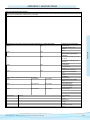
1
A Guide for Getting Started in Volunteer Water Monitoring
ACKNOWLEDGEMENTS
This manual was made possible due to the generous support of State of Hawai‘i Tourism Authority’s Natural Resources
Program. Many thanks to Liz Foote of Project S.E.A-Link for allowing us to partner together and help expand the
volunteer program at Honolua Bay.
Primary Author and Editor: Jill Komoto, Ma-lama Kai Foundation
Mahalo to Hawai‘i Contributors:
Liz Foote Project S.E.A-Link
Megan Webster, Maui Land and Pineapple, Inc.
Randy Bartlett, Maui Land and Pineapple, Inc.
Dr. Carl Evensen, University of Hawai‘i
Dr. Kathy Chaston, NOAA
Hudson Slay, EPA/Hawai‘i Department of Health
Watson Okubo, Hawai‘i Department of Health
Darrell Kuamo’o, DLNR-DAR
Matt Rosener, Hanalei Watershed Hui
Carolyn Stewart, Ma-lama Kai Foundation
Melora Purell, Kohala Watershed Partnership
Alyssa Miller, Ma-lama Maunalua
Alan Lipp, Glenwood Greens
Signe Opheim, UH Sea Grant
Jeff Zimpfer, US Fish and Wildlife Service
Judy Edwards, Ranger, Ahihi-Kina‘u NAR
John Replogle, Ka ‘Ohana O Honu’apo
Alastair Hebard and Randall Scarborough, Hawaiian Islands Humpback Whale National Marine Sanctuary
I’d like to thank those on the mainland who I’ve met at various water quality conferences the past several years. The
volunteer water monitoring community is one of the very helpful, knowledgable and dedicated group of people I have
met. Many thanks to Erick Burres, California’s Citizen Monitoring Program, Linda Green of University of Rhode
Island, Cooperative Extension, Amy Wagner and Audrey Shikelis, EPA, Region 9.
Many thanks to Duane Iwamura’s classes at Maui’s Kamehameha School and Kate Ireland’s Seabury Hall classes for
assistance in testing some of the protocols provided in this manual. Their feedback resulted in changes that we hope
make it easier for you to follow. And thanks to the organizations that provided volunteers to help us train the students:
the Hawaiian Islands Humpback Whale National Marine Sanctuary (Alastair Hebard and Jerry Stowell) and the
Digital Bus (Ellen Federoff & Kelly Ledford).
Cover design and book layout provided by Geoffrey T. Moore, Silver Moon Art and Design
SilverMoonMaui.com
A Guidebook for Getting Started in Volunteer Water Monitoring
iii
TABLE OF CONTENTS
Acknowledgements .................................... i
Acronyms .....................................................2
How to Use This Manual ..........................2
SECTION 1:
Introduction to Water Quality
What is water quality? ...............................3
Why measure the
quality of water? .........................................3
What are the laws to
protect clean water? ....................................3
Federal Clean Water Act........................3
How does Hawaii
control water pollution?.............................4
What are Hawaii’s
water quality standards?
Hawaii Administrative
Rule (HAR), 11-54...................................4
Why should I get involved? ......................6
SECTION 2:
Watershed, Estuarine & Marine Processes
What is a watershed? .................................7
The hydrologic cycle...................................7
Groundwater and streams .........................7
Importance of vegetation .........................10
Geologic factors.........................................10
Estuaries .....................................................10
Nearshore marine environment..............11
SECTION 3:
Water Quality Parameters
Physical.......................................................12
Conductivity/Salinity ............................12
Temperature...........................................12
Total Solids.............................................13
Turbidity.................................................13
Chemical ....................................................14
Chemicals ...............................................14
Dissolved Oxygen..................................15
Nutrients.................................................15
pH ...........................................................16
iv
Trace elements .......................................16
Biological......................................................17
Bacteria.......................................................17
SECTION 4:
How to Get Started;
What You Need to Know
Defining your goals ..................................18
Gather information
about your water body ..........................18
How much funds do you have? ..............19
Where can I find funding?...................19
How much experience do you have?
Is there someone who can help?..............19
What is your time commitment?............19
If you’re not ready to start
monitoring- other events..........................19
The Great North American Secchi Dip ...19
In World Water Monitoring Day ...........19
International Coastal Cleanup.............19
Alien Algae Cleanup.............................20
Storm drain stenciling...........................20
Marine debris cleanup...........................20
Adopt-A-Stream/Reef/Highway.........20
Snapshot Day .........................................20
SECTION 5:
Three Levels of Volunteer Monitoring
(Depends on Your Goals!)
Introduction...............................................21
Community Awareness............................21
What’s involved .....................................21
Planning your event ..............................21
Protocols to consider .............................22
Community Involvement ........................22
What’s involved .....................................22
Planning your monitoring program ...23
Getting started ......................................21
Additional information gathering..........23
Selecting monitoring sites.....................23
Data management ................................23
Budgeting .............................................23
Hire a project coordinator....................24
Developing standard
operating protocols ................................24
Develop team leaders and
recruit volunteers...................................24
Fieldwork kit .........................................24
Protocols to consider .............................25
Community Assessment...........................25
What’s involved .....................................25
Planning your monitoring program ...25
Getting started ......................................25
Additional information gathering...........25
Selecting monitoring sites .................26
Data management ................................26
Budgeting .............................................26
Hire a project coordinator....................27
Quality Assurance
Project Plan (QAPP).............................27
Overview...............................................27
Steps involved .......................................27
QAPP concepts .....................................28
Quality control (QC) samples ..............28
Elements of a QAPP.............................29
Develop team leaders
and recruit volunteers ...........................30
Fieldwork kit .........................................30
Protocols to consider .............................30
SECTION 6:
Volunteer Management
Rights and responsibilities –
volunteers and volunteer program..........33
Recruiting volunteers ...............................33
Retaining volunteers.................................34
Recognition of volunteers ........................35
Training volunteers ..................................35
SECTION 7:
Data Management
Overview ....................................................37
What information you need
to know to plan your database.................37
What resources do I have available? ......37
Who will use the data? .........................37
Taking Care of Hawai‘i’s Waters
TABLE OF CONTENTS
How will the data be used?..................37
How will you control the
reliability of the data? ...........................38
What type of security do you need?.......38
Web-based databases ................................38
SECTION 8:
Transporting Samples and Safety
Shipping and Custody..............................39
Transfer of custody and shipment ..........39
Laboratory sample control procedures ...40
Safety ..........................................................40
Risk Assessment ....................................41
Insurance coverage ................................41
Safety tips................................................41
SECTION 9:
Field Manual Protocol Guide
Prior to monitoring...................................43
Preparing collection containers...............43
Where to sample –
streams and coastal waters .......................43
Sample collection ......................................43
Collecting standard samples
in shallow water.....................................43
Using a Whirlpak bag ..........................43
Using a bottle........................................44
Collecting a standard sample
in deep water..........................................44
Collecting a preserved sample .............44
Cleaning sampling containers..............44
Equipment storage and maintenance....44
Physical ...................................................44
Conductivity/Salinity ...........................44
Hydrometer.....................................44
Refractometer..................................45
Cole Parmer Con 400 meter............45
Temperature .........................................46
Lamotte kit ......................................46
Pocket field thermometer ..............46
Total Dissolved Solids ..........................46
Oakton Waterproof TDSTestr 2, 3....46
Send sample to lab ..........................48
Turbidity...............................................48
Lamotte kit ......................................48
Secchi disk .......................................48
Transparency tube ..........................48
Lamotte portable turbidimeter........49
Chemical.................................................49
Chemicals .............................................49
Lettuce seed bioassay......................49
Detergents- Hach model DE-2 .......51
Dissolved Oxygen..................................51
Lamotte kit ......................................51
Chemetrics DO kit .........................52
YSI 55 Dissolved oxygen meter .......52
Nutrients...............................................53
Nitrate .............................................53
Lamotte kit....................................53
Chemetrics Nitrate kit
(Cadmium method) ......................54
Phosphate.........................................55
Lamotte kit....................................55
Chemetrics Phosphate kit..............55
Nitrogen-Ammonia .......................55
Chemetrics Ammonia-Salicylate .....55
Chemistry method kit....................55
Send sample to the lab....................56
pH .......................................................56
Lamotte kit ......................................56
pH strips...........................................56
Hach colorimeter 17-N
wide range kit .................................57
Oakton waterproof pH 300 meter .....57
Biological..............................................57
Bacteria.............................................57
Lamotte GREEN water
monitoring kit .................................57
Coliscan Easygel for E. Coli ..........58
IDEXX Quanti-tray for enterococci....59
Send sample to the lab....................59
SECTION 10:
Stream Measurements
Stream flow ................................................62
What is stream flow? ............................62
Why measure it?....................................62
Summary of methods .........................62
Methods for monitoring flow...............65
Observations .........................................65
Estimates...............................................65
Measurements.......................................65
Volume per unit time .....................65
Fill container and timepiece .........65
Float method .................................66
Electromagnetic current meter ..........67
Visual observations ...................................69
What are visual observations ...............69
Why use visual observations ................69
Protocols .................................................69
‘o-pala .......................................................73
What is ‘o-pala?.......................................73
Why measure ‘o-pala? ............................73
Protocols .................................................74
Fish and Invertebrates ..............................75
What is a rapid assessment
of fish and invertebrates?......................75
Why conduct a rapid assessment?.......75
Protocols .................................................75
A Guidebook for Getting Started in Volunteer Water Monitoring
SECTION 11:
Watershed Measurements
Rainfall and runoff ...................................77
What is stormwater runoff? ................77
Why measure rainfall? .........................77
Protocols .................................................77
Pollution hotspots .....................................78
What are pollution hotspots?...............78
Why look for pollution hotspots?........78
Protocols .................................................78
Storm drain monitoring...........................79
Introduction ...........................................79
Getting started .......................................80
Safety.......................................................80
Sample collection ...................................80
Using the storm drain kit .....................80
General protocols..................................80
Individual kit instructions....................81
Cleaning the kit ....................................82
SECTION 12:
Other Coastal and Ocean Measurements
Current and weather observations..........83
What are current, ocean
and weather observations? ...................83
Why measure currents, ocean
and weather conditions?.......................83
Protocols .................................................84
Aquatic invasive species monitoring.........84
Coral Bleaching.........................................85
References ...............................................86
APPENDIX A:
Other volunteer water
monitoring manuals .............................87
APPENDIX B:
Other organizational
resources/contacts ..................................87
APPENDIX C:
Sample Forms ........................................93
APPENDIX D:
Funding resources ...............................109
APPENDIX E:
Equipment and Supply vendors........116
APPENDIX F:
Other Applicable Federal,
State, and Local laws ..........................117
APPENDIX G:
Method for calculating
latitude and longitude ........................118
APPENDIX H:
Glossary ................................................120
1
HOW TO USE THE VOLUNTEER WATER MONITORING MANUAL
This manual is provided as a guidance tool for those interested in
getting started in volunteer water monitoring; it is not intended to
cover all aspects and protocols involved in volunteer monitoring.
Each area/site provides its own challenges. While many of the
protocols have been tested by volunteers, - your site, access to
technical experts and equipment and abilities of your volunteers
will differ. Please feel free to copy anything in this manual and
adopt/change as needed for your particular area.
and recording and fish/invertebrate rapid assessments are all indicators of
the health of the stream and its resulting impact on coastal areas.
Section 11: Watershed measurements
Watershed measurements are an important component of water quality
monitoring. In this section, you’ll learn about how to record rainfall, some
tools for estimating runoff, how to identify areas of pollution “hotspots”
(source of potential pollution), and how to conduct storm drain monitoring.
Section 12: Other coastal and ocean measurements
In this section you’ll learn about the basics of water quality, what are water
quality standards, why we should monitor water quality and why you
should get involved.
Other ocean related monitoring that can help in understanding the
health of coastal resources is measuring ocean currents, tides, observing
the weather, looking for aquatic invasive species and identifying coral
bleaching and marine disease.
Section 2: Watershed, estuarine and marine processes
Appendix A: Other volunteer water monitoring manuals
HOW TO USE THIS MANUAL • ACRONYMS
Section 1: Introduction to water quality
This section gives an overview of watersheds, streams, estuaries, the
hydrologic cycle and more.
Sources for other volunteer manuals.
Section 3: Water quality parameters
This is a list of additional resources to assist you in developing your
program, including contact information.
Learn about the various water quality parameters, why they are monitored,
the various methods used and how changes can impact the health of the
waterbody, humans and aquatic life.
Section 4: How to get started
This section outlines the basics of what you need to know in order
to get started in volunteer water monitoring. By asking yourself the
simple question of “what is your goal”, you can determine what level of
involvement you should be in. And if you aren’t ready to get started, there
is a list of some events organized by others.
Section 5: Three levels of volunteer monitoring
This section gives an overview of the different levels of monitoring,
depending on your goals. It lists what might be involved at each level, and
tells you how you might plan your monitoring program. At the end of each
level, it references the various protocols you might consider as part of your
program in sections 9-12.
Section 6: Volunteer management
Appendix B: Other organizational resources/Contacts
Appendix C: Sample forms
Here you find a variety of forms and templates you can use, or modify for
your own program.
Appendix D: Funding resources
Wondering how you can fund your program? Look here to locate an
appropriate funding source.
Appendix E: Equipment and supply vendors
Here is a list of commonly used water quality supply vendors.
Appendix F: Applicable Federal, State and Local Laws
Know your laws! It is important that you understand the laws that
government agencies, businesses, landowners and the community must
comply with.
Appendix G: Glossary
Wondering how to recruit volunteers? This section gives an overview of
how to recruit, train, manage and retain your volunteers, with tips from
those who have developed programs elsewhere.
What does that term mean? Here is a list of common water quality and
other related terminology, including Hawaiian words.
Section 7: Data management
Don’t have a GPS unit to determine your location? Here is a method using a
topographic map, ruler and calculator to determine latitude and longitude.
What will you do with the data you collect? What’s the best method to
use? This section gives an overview of various ways to manage your data,
which depends on the level of involvement you’ve selected in section 3.
Section 8: Transporting samples and safety issues
If you will not be analyzing your samples on site, or will be transporting the
samples to a lab, here are some protocols to use. And safety, safety, safety!
Remember these precautions to pass along to your volunteers.
Section 9: Field manual
This section lists some protocols that you can use for monitoring water
quality, by code. It is meant to be a simple pullout section that you can
make multiple copies of, or laminate.
Section 10: Stream measurements
Want to get involved in more than water quality monitoring? Monitoring
the flow, recording visual observations during a stream walk, opala cleanup
2
Appendix H: Determining Latitude and Longitude
ACRONYMS:
CWA: Clean Water Act
DAR: Division of Aquatic
Resources
DLNR: Department of Land
and Natural Resources
DO: Dissolved Oxygen
DOH: Department of Health
EPA: Environmental Protection
Agency
GPS: Global positioning satellites
HAR: Hawaii Administrative Rule
HRS: Hawaii Revised Statute
MPN: Most probable number
NRCS: Natural Resources
Conservation Service
QA: Quality Assurance
QC: Quality Control
QAPP: Quality Assurance
Project Plan
SOP: Standard Operating Protocols
STORET: Storage and Retrieval
(data management system by EPA)
TMDL: Total Maximum Daily Load
USACE: United States Army
Corps of Engineers
USGS: United States Geological
Survey
Taking Care of Hawai‘i’s Waters
Photo by Liz Foote
SECTION 1: INTRODUCTION TO WATER QUALITY
Honolua Bay
Water quality measures the biological, chemical and physical
attributes present in the water column. These attributes
include oxygen content, temperature, salinity, turbidity,
nutrient loading, amount of sediment and the presence of
bacteria, metals, and other toxins. The sources of water
pollution can be natural or anthropogenic (human induced),
and are identified as either point sources or nonpoint sources.
Natural sources of altered water quality include minerals
worn from rocks or sediment from erosion. Point sources
have a discrete discharge location, such as a pipe or culvert,
and include wastewater treatment plants, power plants,
and industrial facilities that discharge wastewater effluent.
Nonpoint sources do not have discharges coming out of a
defined point, but are difficult to identify and are typically
conveyed as general runoff or groundwater seepage. Examples
of nonpoint sources include surface runoff from agricultural
land or urban areas.
Why Measure the Quality of Water?
The quality of water can affect the suitability of water for
drinking, recreation, wildlife, agriculture, and other every
SECTION 1: INTRODUCTION TO WATER QUALITY
What is Water Quality?
day use. Anything that flows from yards, streets and gutters
enters the storm drain and flows to the streams and ocean
untreated. For example, fertilizer contains nitrates, which in
disproportionate quantities can upset the ratio of nitrogen to
phosphorus, nutrients that plants need for growth, but also
cause the excessive production of algae. Too much algae can
limit the amount of oxygen that other plants and fish need
or crowd out native plants and algae. Other pollutants such
as bacteria are carried by the stream to the ocean and can
cause bacterial levels to exceed state standards for recreational
contact. High levels of bacteria can indicate an increased risk
of disease for people who swim, surf, snorkel, dive, fish or have
other contact with the stream or ocean water. Metals such as
lead and copper found in brake pads have been found in fish
and can cause changes in reproductive behavior. Symptoms in
humans can range from excessive headaches to kidney damage.
These metals are found in significant quantities during storm
water runoff. Researchers are even finding concentrations
of the ingredients of sunscreen products in fish and other
marine organisms. When streams are stripped of vegetation
or buildings placed too close to the stream banks erosion can
occur. The concrete streambeds facilitate the transfer of the
sediment to the ocean, where it can smother corals.
What are the Laws to Protect Clean Water?
Federal Clean Water Act (CWA)
In 1972, the Clean Water Act, then the Federal Water
Pollution Control Act, was created. Over the years it has had
several amendments and modifications, as well as other acts
passed to work in coordination with CWA. The statute was
implemented to “restore and maintain the chemical, physical,
and biological integrity of the Nation’s waters” (33 USCA §
1251(a)) as its main goal. The Environmental Protection Agency
(EPA) works with the state to set standards of acceptable levels of
pollutants in water bodies in order to ensure a designated water
quality standard. These standards consist of three components:
1) designated uses of water, 2) water quality criteria to protect
the uses, and 3) an antidegradation policy directed at keeping
healthy waters healthy.
The State of Hawai‘i Department of Health (DOH) is
required to designate uses for each waterbody. These uses
include: swimming, drinking water and aquatic life. The
designated use is a goal; that is, the waterbody may be
designated for use of swimming, but perhaps not clean enough
yet. DOH sets numeric and narrative water quality criteria
to protect these uses. Numeric criteria define a maximum
amount of a particular characteristic such as bacteria, metals
or nitrates in the water. Narrative criteria (e.g “no sediment
loading above natural conditions”) may serve as a “catch-all”
or a backup when numeric criteria have not (or can not) be
developed. Antidegradation policies are developed to limit
activities that will spoil existing water quality or improvements
that have been achieved.
A Guidebook for Getting Started in Volunteer Water Monitoring
3
SECTION 1: INTRODUCTION TO WATER QUALITY
SECTION 1: INTRODUCTION TO WATER QUALITY
Every two years, the DOH must provide a Biennial Water
Quality Report to Congress, also known as the 305(b) report.
This report (required by Section 305(b) of the Clean Water
Act) includes an assessment of the States’ waters to determine
if designated uses are being met. CWA Section 303(d)
requires the DOH to prepare a list (every two years as well)
of threatened and impaired waters and then develop cleanup
plans for the waters on this list based on the total maximum
daily load (TMDL) of pollutants that the waterbody can
receive and still meet the water quality standards. A TMDL
basically is a cap for every problem pollutant in the waterbody.
It is divided into potential sources: 1) Background conditions,
2) Allocations for all point sources – also known as “wasteload
allocations”, 3) Allocations for all the nonpoint sources – also
known as”load allocations”, and 4) Margin of safety. But after
developing these TMDLs, a strategic plan with a timeline is
needed to achieve these TMDLs. Changes may be made to
existing permits, which include improving or enacting “best
management practices”. (BMPs).
Point source example.
Point source polluters must either have a permit to continue
dumping, must meet the standards allowed for release, or
must not discharge anything that will disrupt the integrity of
the water body. Communities can intervene in the permitting
process, can file administrative appeals if they feel a point source
is not complying with the standards, or they can sue to enforce
regulation and monitoring to be performed. Also, the EPA
regularly holds public meetings to gather input on the adequacy
of water quality standards set.
Under Section 404 of the Clean Water Act (CWA), the United
States Army Corps of Engineers (USACE) and Environmental
Protection Agency (EPA) jointly regulate the discharge of dredged
and fill material into U.S. waters through a permit review process.
Individual and general permits are granted by the USACE.
Permit applicants must prove they have taken steps to avoid
wetland impacts where practicable, minimized potential impacts
to wetlands, and provided compensation for any remaining,
unavoidable impacts. Section 401 of the CWA gives the state the
authority to review and approve, condition, or deny all Federal
permits that might result in discharge to State waters.
4
See www4.law.cornell.edu/uscode/33/ch26.html for full text
of the Clean Water Act.
How Does Hawai‘i Control Water Pollution?
Hawai‘i Revised Statute HRS 342D directs the Director of
the Department of Health to “prevent, control, and abate water
pollution in the State”. DOH “may control all management
practices for domestic sewage, sewage sludge, and recycled
water, whether or not the practices cause water pollution.” In
order to comply with this duty, the Director may enact rules
under Chapter 91 in order to meet these duties.
With regards to civil penalties: If one violates this chapter, any
rule, or any term or condition of a permit or variance issued,
they shall be fined not more than $25,000 for each separate
offense. Each day of each violation constitutes a separate offense.
Administrative penalties may also be imposed.
Negligent violations can incur 1) a fine of not less than
$2,500, but not more than $25,000 per day of violation, or 2)
imprisonment for not more than one year, or 3) a fine and
imprisonment. If a person has been convicted more than once
under this chapter, punishment shall be 1) by a fine of not more
than $50,000 per day of violation, or 2) imprisonment of not
more than two years, or 3) a fine and imprisonment. Negligent
violations include: 1) violations of this chapter, rule, condition
in a permit or requirement imposed in a pretreatment
program; or 2) negligence in introducing any water pollutant
or hazardous substance which the person knew or reasonably
should have known could cause personal injury or property
damage into a sewerage system or into a publicly owned
treatment; or 3) other than in compliance with all applicable
federal, state, or local requirements or permits, which causes
such treatment works to violate any effluent limitation or
condition in any permit issued to the treatment works.
Specifically, HRS 342D-50 states that “No person, including
any public body, shall discharge any water pollutant into state
waters, or cause or allow any water pollutant to enter state waters
except in compliance with this chapter, rules adopted pursuant to
this chapter, or a permit or variance issued by the director.”
What are Hawaii’s Water Quality Standards?
(Hawaii’s Water Quality Standards,
Hawai‘i Administrative Rule: HAR 11-54):
Hawai‘i has a general policy of water quality antidegradation: The overall policies include: 1) Protecting
existing uses and the level of water quality; 2) Maintain and
protect the quality of water in areas where the quality exceed
levels necessary to support propagation of fish, shellfish, and
wildlife and recreation., unless allowing lower water quality
is necessary to accommodate important economic or social
development in the area in which the waters are located….
; and 3) High quality waters in national and state parks and
wildlife refuge with exceptional recreational or ecological
significance shall be maintained and protected.
Taking Care of Hawai‘i’s Waters
SECTION 1: INTRODUCTION TO WATER QUALITY
SECTION 1: INTRODUCTION TO WATER QUALITY
Class AA waters: Hanauma Bay.
These rules classify Hawai‘i State waters as inland or marine
waters. Inland waters can be fresh, brackish, or saline and are
classified based on their ecological or natural characteristics.
Fresh waters are classified as following: 1) Flowing waters
(streams, flowing seeps and springs, ditches and other flumes
that flow into receiving water bodies) 2) Standing waters (lakes
and reservoirs) and 3) Wetlands. Brackish or saline waters
are classified as the following: 1) Standing waters (anchialine
pools or saline lakes) 2) Wetlands and 3) Estuaries. All marine
waters are either embayments, open coastal, or oceanic waters.
Embayments or open coastal waters are also classified according
to the following bottom subtypes: 1) Sand beaches; 2) Lava rock
shorelines and solution benches; 3) Marine pools and protected
coves; 4) Artificial basins; 5) Reef flats; and 6) Soft bottoms.
Inland and marine waters, including marine bottom
ecosystems are further classified according to their uses, and
water quality standards for each parameter are developed for
each type of use, by general or specific location. Inland waters
are comprised of Class 1 and Class 2 waters. The objective
of Class 1 waters is to remain in their most natural state
possible, with the absolute minimal pollution from human
sources. Waste discharge is prohibited in Class 1 waters. Class
1 waters are further divided into Class 1a and1b, where Class
1b uses are limited to scientific and educational purposes and
protection of native breeding stock, baseline references from
which human-caused changes can be measured. Other allowed
uses include compatible recreation, aesthetic enjoyment, and
other nondegrading uses. Class 1b water uses are designated
for domestic water supplies, food processing, protection
of native breeding stock, the support and propagation of
aquatic life, baseline references from which human-caused
changes can be measured, scientific and educational purposes,
compatible recreation, and aesthetic enjoyment. Public access
to these waters may be restricted to protect drinking water
supplies. Class 2 waters objective is to protect their use for
recreational purposes, the support and propagation of aquatic
life, agricultural and industrial water supplies, shipping, and
navigation. These uses must be compatible with the protection
and propagation of fish, shellfish, and wildlife, and with
recreation in and on these waters. No discharge is allowed in
these waters that has not received the best degree of treatment
or control compatible with the criteria established for this class.
Marine waters are comprised of Class AA and A waters. The
objective of class AA waters is to remain in their most natural
state possible, with the absolute minimal pollution or alteration
of water quality from human sources. Waste discharge is
prohibited in Class AA waters. No zones of mixing are allowed
in Class AA waters to include: 1) Within a defined reef area, in
waters of a depth less than 18 meters (ten fathoms) or 2) Within
a defined reef area, in waters of a depth less than 18 meters
(ten fathoms). The uses to be protected in this class of waters
are oceanographic research, the support and propagation of
shellfish and other marine life, conservation of coral reefs
and wilderness areas, compatible recreation, and aesthetic
A Guidebook for Getting Started in Volunteer Water Monitoring
5
SECTION 1: INTRODUCTION TO WATER QUALITY
SECTION 1: INTRODUCTION TO WATER QUALITY
enjoyment. The objective of Class A waters is to protect their
use for recreational purposes and aesthetic enjoyment. These
uses must be compatible with the protection and propagation
of fish, shellfish, and wildlife, and with recreation in and on
these waters.
Marine bottom ecosystems are divided into Class I and Class
II waters. The objective of Class I waters is to remain in their
most natural state possible, with the absolute minimal pollution
from human sources. Uses of marine bottom ecosystems in
this class are passive human uses without intervention or
alteration, to allow for the perpetuation and preservation of
the marine bottom in a most natural state. This includes uses
such as for nonconsumptive scientific research (demonstration,
observation or monitoring only), nonconsumptive education,
aesthetic enjoyment, passive activities, and preservation. Class
II waters uses are such that the protection for propagation of
fish, shellfish, and wildlife, and for recreational purposes not be
limited in any way.
Basic water quality standards that are applicable to all
waters states that “All waters shall be free of substances
attributable to domestic, industrial, or other controllable
sources of pollutants”, including:
Why Get Involved?
Volunteer water quality monitoring programs help to build
stewardship of local waters. Volunteers learn about the value
of our water resources, the types of pollution impacting them
and what they can do individually to protect our streams and
coastal waters. A water quality monitoring program can help
make the connection between watershed health and the health
of our oceans, as well as build bridges among the community,
businesses and various government agencies.
State agencies have limited funds for monitoring; thus
many waterbodies are not monitored on a regular basis. Data
volunteers obtain can be used to update the 303(b) list and
potentially list a waterbody on the 303(d) list, paving the way
for the State to develop TMDLs and an action plan to improve
water quality in your area.
6
Photo by Liz Foote
1. Materials that will settle to form objectionable sludge or
bottom deposits;
2. Floating debris, oil, grease, scum, or other floating
materials;
3. Substances that produce a distinguishable taste in the water
or detectable off-flavor in the flesh of fish, or in visual
observed changes in color, turbidity or other conditions in
the receiving waters;
4. High or low temperatures; biocides; pathogenic organisms;
toxic, radioactive, corrosive, or other harmful substances at
levels or in combinations sufficient to be toxic or harmful to
human, animal, plant, or aquatic life, or in amounts
sufficient to interfere with any beneficial use (see above use
classifications) of the water;
5. Substances or conditions or combinations thereof in
concentrations which produce undesirable aquatic life (such
as an increase in algae); and
6. Soil particles resulting from erosion on land involved in
earthwork, such as the construction of public works;
highways; subdivisions; recreational, commercial, or
industrial developments; or the cultivation and management
of agricultural lands.
To comply with the above criteria, all state waters are subject
to monitoring and standards for acute and chronic toxicity and
the protection of human health.
Please read HAR 11-54 for more detail and information.
Taking Care of Hawai‘i’s Waters
Photo by Liz Foote
SECTION 2: WATERSHED, ESTUARINE & MARINE PROCESSES
What is a watershed?
Originally, a watershed was defined as a dividing line
between two drainage basins. Presently, according to the
United States Environmental Protection Agency, “A watershed
is a geographic area in which all sources of water, including
lakes, rivers, estuaries, wetlands, and streams, as well as ground
water, drain to a common surface water body.” In the case of
Hawai‘i, the watershed areas are all relatively small, and in
almost all cases the drainage basins end up in the ocean.
Traditionally, the Hawaiians had a land division system
known as the ahupua’a. These were areas that incorporated all
the land from the sea to the tops of the mountains. They were
developed so that each community would have access to the
various resource needed to sustain life: from the sea where fish
and seafood could be gathered, into the midlands where water
and streams made agricultural pursuits bountiful, to the higher
mountains where remaining native forests contained wood and
resources for building.
It just so happens that these ahupua’a were often based on
the geographical contours of a single valley, or what is now
known as a watershed. In other words, here in Hawai‘i,
watershed areas at one time contained all the resources
required to sustain life. While we no longer live in a system
that requires sustainability in small areas, we can certainly
benefit from keeping the ahupua’a concept alive and well by
utilizing the knowledge of the Native Hawaiians.
What is the hydrologic cycle?
The hydrologic cycle is the never ending cycle which water
goes through. Whatever water we have here on earth is here
to stay; either in water or vapor form, or locked up in the form
of ice. In the basic model, it consists of five states: evaporation,
condensation, precipitation, infiltration and runoff.
Evaporation is the start of the cycle, where water is taken
into the atmosphere in vapor form. When temperature and
humidity levels reach a critical state, this causes condensation,
usually in the form of clouds. When the clouds cool and can
no longer hold the moisture, precipitation occurs. This is in the
SECTION 2: WATERSHED, ESTUARINE & MARINE PROCESSES
Westside Maui watershed, photo by Liz Foote
form of rain, snow, hail, etc.
As the precipitation reaches the ground, a portion of it
infiltrates, or soaks, into the ground, while some flows on the
surface and becomes runoff. All the while, as this occurs,
evaporation and condensation are still taking place.
The water that infiltrates the ground usually goes to
replenish the aquifer or water table. This is water that
saturates the ground and is held in place by various factors.
Meanwhile, the runoff water flows due to gravity in the
watershed to streams, ponds, puddles and in Hawaii’s case,
eventually the ocean. Various models for different areas can
calculate the amount water that infiltrates, evaporates and
becomes runoff.
In more complex models, the cycle takes into consideration
factors such as transpiration, which is the direct vapor loss from
trees and vegetation into the atmosphere. Another variable to
be considered is ice, which can temporarily take the water out of
the cycle until it melts. For this reason, global warming, which
would melt much of the polar ice and re-introduce the water it
contains into the hydrologic cycle is a concern, although no one
really knows what factor this excess water would have on the
cycle. Some scientists feel that the excess water may exacerbate
the warming while others believe that it may lessen its effect. In
areas with high snowfall, the accumulated snow, also known as
snowpack, generally stays throughout winter then gradually melts
and, like rain, is taken in as groundwater as well as runoff. Many
of the temperate regions of the world are very dependent on this as
a source of their water; however, in Hawai‘i there are few areas that
receive much snowfall so it does not have much of an impact here.
What is groundwater and why is it important?
Groundwater is that water which has already infiltrated the
water table. In Hawai‘i, it usually forms into a lens shape, floating
on the surrounding seawater. The edges of the freshwater lens
are always draining into and mixing with the surrounding ocean
water. In general, groundwater, due to the filtration process, is
cleaner than surface runoff, however various factors come into
play including how porous the surface is.
Areas with higher porosity, such as sand or volcanic
basalt on the newer islands are very conducive to capturing
groundwater, but that same porosity allows bacterial, viral and
chemical infiltration as well. In east Hawai‘i Island, an area
of porous volcanic basalt where cesspools are the norm, high
fecal coliform counts in the surrounding inshore waters are
common. It is for that reason that septic tank systems, with
a leach field (a surrounding area of lower porosity designed
to filter out pollutants) have been mandated by law for any
property of less than one acre on the Island of Hawai‘i.
Areas with lower porosity, found on the more eroded older islands
have had the accumulation of soil and eroded volcanic basalt fill
in the porous bedrock thus making permeability much lower and
percentage of runoff versus infiltrated water much higher. Luckily,
the soils of the older islands are much more conducive towards the
growth of vegetation than the lava fields of the newer islands.
A Guidebook for Getting Started in Volunteer Water Monitoring
7
THE HYDROLOGIC CYCLE
SECTION 2: WATERSHED, ESTUARINE & MARINE PROCESSES
CONDENSATION
PRECIPITATION
EVAPORATION
rs
ate
W
ace
urf
S
Spring
Ocean
Groundwater
8
Taking Care of Hawai‘i’s Waters
SOURCES OF INPUTS INTO WATERSHEDS
Heavy rains lead to stormwater
runoff, which can carry pollutants
and trash into waterways.
SECTION 2: WATERSHED, ESTUARINE & MARINE PROCESSES
Improper
household
water use can
contribute
pollutants to
streams.
Runoff from poor irrigation and land
practices on agricultural lands can
contribute fertilizer, pesticides and
herbicides into waterways.
Illustration by Riki Inzano • [email protected]
Channelized streams carry water
faster and at higher volumes, but can
contribute to flooding and stream
bank erosion; resulting sediments
can smother corals.
A Guidebook for Getting Started in Volunteer Water Monitoring
9
SECTION 2: WATERSHED, ESTUARINE & MARINE PROCESSES
SECTION 2: WATERSHED, ESTUARINE & MARINE PROCESSES
Streams can be classified by three types of general behavior:
perennial, or streams that flow year round, nonperennial, or
those that flow only intermittently, and ditches, which are
man made diversions. These three genotypes of streams can
be known by a number of terms including river, creek, crick,
gulch, gully, canal, ravine, drainage basin etc.
Perennial streams continuously carry water from the
mountains to the sea. Since this can contain pollutants, it is
these streams, along with groundwater discharge, that create
the base level of pollutants entering the estuaries and sea. In
times of heavy rains or flooding, additional pollutants can enter
through intermittent streams as well as ditches.
The latter two types of streams (nonperennial and ditches)
can be problematic in times of heavy rains, because in the case
of intermittent streams, pollutant levels can accumulate for a
considerable time before being washed into the stream thus
spiking pollutant levels to unacceptable high levels.
In the case of man made ditches, especially those designed
just for overflow during floods, the natural features of a stream
that slow down the flow of water such as curves and rocks,
sand and gravel areas and riparian vegetation, are absent. This
allows the polluted water to flow unhindered to the sea. There
is one final defense, however, and that is an estuary.
Photo by Jill Komoto
Hawai‘i Streams
Waiulaula Stream, Hawai‘i
enter critical areas, and the presence of live vegetation and its
resultant organic material can create a sponge-like effect that
holds the water and slowly lets it infiltrate the ground.
As with any generalization, there are instances where
vegetation may not actually be the best solution for
groundwater replenishment. In some areas with highly
permeable surfaces such as sandy areas or volcanic basalt,
even without vegetation the infiltration is very high, and the
introduction of deep rooted non-native trees has been shown to
decrease the water table.
What is an estuary and why is it important?
Photo by Jill Komoto
According to the US EPA, “An estuary is a partially enclosed
body of water along the coast where freshwater from rivers and
streams meet and mix with salt water from the ocean. Estuaries
and the lands surrounding them are places of transition from
land to sea, and although influenced by the tides, they are
protected from the full force of ocean waves, winds, and storms
by such landforms as barrier islands or peninsulas.”
Estuaries are an excellent habitat for all manner of flora
and fauna: from freshwater plants in the upper regions to salt
tolerant plants nearer to the sea, and from birds and animals on
Moloka‘i
Generally, healthy ecosystems have a balance with a higher
amount of infiltration than runoff. An excess of runoff can
cause environmental damage in many ways. These include:
direct erosion, transporting pollutants, and not allowing for
infiltration, thereby not replenishing the water table.
Vegetation is an excellent way to counter all of the above
negative impacts of excessive runoff. Trees, shrubs and grasses
can slow down the rate at which water flows along the ground
and their roots will also hold the soil in place to prevent direct
erosion. They can also catch and trap pollutants before they
10
Photo by John Replogle
Why is vegetation, like trees and shrubs
important?
Honu‘apo Estuary
Taking Care of Hawai‘i’s Waters
SECTION 2: WATERSHED, ESTUARINE & MARINE PROCESSES
Photo by Jill Komoto
land to fish hatcheries and shellfish in the water.
As fresh water flows through the plants in the estuaries some
contaminants are trapped and filtered by the plants, the excess
nutrients are taken up by the plants, and the slow intermixing of
the runoff and seawater acts like a settling pond, where much of
the sediments settle to the bottom and don’t reach the sea itself.
One prime example of estuarine loss and its effect on the
ocean is Waikiki on Oahu. In the past, much of that area was
estuarial wetlands, but progress filled in the area and created
the Ala Wai canal as the main outlet to the sea.
Coastal environments
SECTION 2: WATERSHED, ESTUARINE & MARINE PROCESSES
Wai‘opae Tidepools, Hawai‘i
One experiment being done right now in the Ala Wai
is the planting of rafts of aquatic plants that take up the
pollutants. While this may not be as effective as natural
wetland restoration, it is at least a step in the right direction,
and shows that technical solutions can help lessen our impact
on the environment. Additional actions such as keeping
pollutants off the streets and out of the storm drains, planting
appropriate vegetation in denuded areas, taking pro-active
steps to minimize sewage releases into the streams, etc. can be
beneficial to the health of the nearshore waters.
Photo by Jill Komoto
Coastal environments include anchialine ponds, tidepools
and coral reefs.
Anchialine ponds: Hawai‘i is the only state in the USA
to contain anchialine ponds. These are brackish ponds that
form on lava flats near the sea, and are connected to the ocean
by underground lava tubes. Seepage allows some seawater
to enter the ponds, which then mixes with the groundwater
from the freshwater lens. Due to their isolated nature, unique
subspecies of aquatic life have formed over the millennium.
Over the years many have been lost due to being filled in for
construction projects, and further threatened by introduced
exotic fish that throw the whole ecosystem out of balance and
kill off the endemic species.
Tidepools: Tidepools differ from anchialine ponds in
that they are connected by surface infiltration of seawater.
This occurs as the tides rise and fall everyday. While not as
ecologically unique as anchialine ponds, tidepools can form a
sheltered habitat for many nearshore species as well as areas
for people to explore, snorkel in etc.
Nearshore waters: As we see in the case of Waikiki,
nearshore environments can be detrimentally affected by loss of
the natural mountain to sea flow of the water. Polluted water
not only has an effect on the whole nearshore ecosystem, but
on the human use of the area. Since this area is heavily used by
the public, and is one of the hallmark tourism areas, steps are
being taken to lessen the pollution entering the sea.
Anchialine ponds, Ahihi Kina’u, Maui.
A Guidebook for Getting Started in Volunteer Water Monitoring
11
SECTION 3: WATER QUALITY PARAMETERS
Physical parameters measure solids, plastics and debris
in the water, as well as the color, taste, or heat of the water.
This section describes the parameters of salinity (taste),
temperature (heat), total dissolved solids (solids) and turbidity
(solids- cloudiness). See section 10 for information on visual
assessments and assessment of trash.
Conductivity/Salinity
SECTION 3: WATER QUALITY PARAMETERS
What is salinity and why is it important?
Salts that dissolve in water break into positively and
negatively charged ions. Conductivity is the ability of water to
transmit an electrical current, and the dissolved ions are the
conductors. Salinity measures the amount of salts in the water.
Dissolved ions increase both conductivity and salinity, so the
two are related. High salinity values can impact ecological
value of surface waters and limit usage for recreation,
agriculture and industries. Fresh and marine water organisms
have very different tolerances to changes in salinity. One
cause of increased salinity (in additional to tidal fluxes) is land
management practices such as over-clearing of vegetation that
increases the recharge of water to groundwater resources. The
water table is brought closer to the surface and thus increases
the amount of the salt-laden groundwater into the streams or
introduces more salt into the stream from runoff. Increases
in irrigation or domestic use can also cause the water table to
rise and flow can decrease as a result. Corals tolerate a narrow
range of salinity values between 30 to 40 parts per thousand.
What affects it in water?
Rain! In pristine environments, rainwater conductivity
equals zero (i.e., the rain is essentially distilled water). Rain
falling into a waterbody, or rain runoff flowing into it, will
decrease conductivity/salinity.
Minerals: Soil and rocks release ions into the waters that
flow through or over them. The geology of a certain area will
determine the amount and type of ions. Spring water typically
shows higher conductivity than inland rain water.
Ocean Spray: The salinity/conductivity of coastal rivers is
influenced by sea spray that can carry salts into the air, which
then fall back into the rivers with rainfall.
Tides and mixing zones: A mixing zone is an area where fresh
and salt water merge together. In flat areas, water at the stream
mouths are often salty because of salt water intrusion during
high tides. The flow of streams into estuaries can greatly affect
salinity as well as the location of the estuarine mixing zone.
This is very important to the survival of estuarine organisms.
Evaporation: Evaporation and loss of fresh water will
increase the conductivity and salinity of a waterbody. Warm
weather can even increase ocean salinity.
Photo by Jill Komoto
Physical Parameters:
Refractometer
How is it measured and reported?
Conductivity meters: These electronic meters use a probe
that applies voltage between two electrodes, spaced a known
distance apart, and records the drop in voltage. These meters
are best for measuring fresh or brackish waters.
Refractometer: A refractometer measures the ability of the
water to refract light.
Hydrometer: The specific gravity, or density, of water is
higher when the dissolved solids (salt and other substances) in
the water are higher. A hydrometer measures specific gravity
which can then be converted to salinity.
Conductivity and salinity results are usually expressed in
grams/liter (g/l) or parts per thousand (ppt) for sea water
(Pacific Ocean waters are around 32 g/l in winter). In
freshwater the term “total dissolved solids” (TDS) is often used
for the same thing instead of “salinity”. Useful TDS units are
milligrams/liter (mg/l) or parts per million (ppm).
12
Fresh and salt water mixing, Kiholo Bay, Hawai‘i
What can I expect to find?
Generally, DOH standards state that salinity shall not vary
more than ten per cent from ambient conditions (wetlands,
estuaries) or natural or seasonal changes considering hydrologic
input and oceanographic factors (all other areas). DOH’s
website shows values ranging from 1.45 (in a river) to 35.4
g/L (ppt-parts per thousand) during a period in September.
Hanalei Watershed Hui reported average salinity values of 1-4
ppt for monitored streams and 29-34 ppt in ocean waters.
Temperature
Why is temperature important?
Many aquatic organisms require clean, cool water for
reproduction and growth. Temperature of a water body can
vary due to seasonal and diurnal influences. Inflowing water,
flow rate, wind speed, air temperature and riparian shade can
Taking Care of Hawai‘i’s Waters
SECTION 3: WATER QUALITY PARAMETERS
Photo by Jill Komoto
will pass through a filter with pores of around 2 microns (0.002
cm) in size. Suspended solids include silt and clay particles,
plankton, algae, fine organic debris, and other particulate
matter. These are particles that will not pass through a 2-micron
filter. Along with turbidity, total solids can be an indicator
of poor management practices in construction, agriculture,
logging, wastewater discharges and other sources. Total solids
can affect the water balance in the cells of aquatic organisms,
and chemicals and other toxicants attach to solid particles.
Concrete stream, O‘ahu
How is it measured and reported?
Temperature strips: These are quick and easy strips which
change color to indicate the temperature.
Bulb Thermometers with colored alcohol (avoid mercury
thermometers): The thermometer is lowered three inches in the
water, and read after 2 minutes.
Temperature probes and meters: These usually come with
other meters, such as pH or conductivity. The probe is placed
in the water, and the temperature can be recorded separately,
or some meters come with data loggers.
Hobo temperature loggers: These data loggers can be placed
in the water for continuous measurements. The logger is
removed and data is downloaded directly into a computer.
SECTION 3: WATER QUALITY PARAMETERS
all affect water temperature. Concrete channelization of streams
to provide for flood control can also increase water temperature
and decrease recharge to groundwater due to the impervious
surface and removal of a vegetative canopy cover which
provides shade. Coral reef bleaching is associated with high
temperatures, with concerns of impacts from global warming.
How is it measured and reported?
Total solids are measured in milligrams per liter (mg/L).
They are usually measured in a laboratory by weighing the
amount of solids present in a known volume of sample. There
are some electronic devices on the market, including several by
the Onset Corporation.
What can I expect to find?
The State of Hawai‘i HAR 11-54 includes water quality
standards for total suspended solids: for inland waters there are
two different standards, one for the dry season May 1 through
October 31, and one for the wet season November 1 through
April 30.
Turbidity
What is turbidity and why is it important?
Turbidity is a measure of water clarity. When a water body
is cloudy it is often due to the runoff of sediment containing
small clay particles or other organic particles and can also
be associated with excessive algal growth or point source
pollution. Turbidity varies naturally with the soil type, for
example a clayey soil is dominated by very small sized clays
which remain suspended and cause the water to be turbid for
several days. Over clearing of vegetation can result in increased
erosion and turbidity in the streams and nearshore waters.
Sediment particles suspended in seawater can prevent light
from reaching corals and as it settles, can smother them.
Photo by Judy Edwards
What can I expect to find?
DOH standards indicate generally that temperature shall not
vary more than one degree Celsius from ambient conditions. In
streams, the temperature shall not exceed 30 degrees Celsius,
as a function of recent rainfall events and elevation at the
sampling sites. Typical temperature ranges are: coastal waters~23° - 27°C (71° - 81°F); streams 16° - 21°C; (60° - 70°F); in
streams that have been channelized, temperatures can be found
up to 30°C or more (86°F +).
Total Solids
What are total solids and why is it important?
Total solids are elements that are suspended or dissolved
in water; the residue that remains after a water sample is
evaporated. Solids in water have different attributes and sizes.
In stream water, dissolved solids consist of calcium, chlorides,
nitrate, phosphorus, iron, sulfur, and other ions particles that
A Guidebook for Getting Started in Volunteer Water Monitoring
Erosion at Baldwin Beach, Maui
13
SECTION 3: WATER QUALITY PARAMETERS
SECTION 3: WATER QUALITY PARAMETERS
How is it measured and reported?
Secchi Disk: The observer measures the depth at which the
secchi disc is no longer visible. The results are measured in feet
or meters. This method depends on the amount of sunlight,
shadows and ripples that are in your sample area. Because of
this, it can’t be used in the surf zone or in short depths.
Transparency tube: The observer views an object or a Secchi
pattern through the water in a tube, adding water gradually
till the object is no longer visible. The results are measured in
centimeters or inches. This can be used anywhere, including
the surf zone and is a relative measure of turbidity.
Nepholometer or turbidimeter: This measures how much
light is scattered when directed at a water sample. The units
are reported in nephelometric turbidity units (NTUs) or
Formazin turbidity Units (FTU) which, numerically, mean
the same thing.
What affects it?
Natural Factors
• Algae and nutrient loading
• Suspended sediment from erosion and sediment transport
• Seasonal weather, storm events
• Local stream morphology will determine whether
sediments are deposited or eroded
Human Factors
• Erosion due to removal of riparian vegetation, changes in
stream morphology or stream flow patterns
• Excessive nutrient loading and algal growth
What can I expect to find?
DOH standards for turbidity are different depending on the
area. DOH’s website shows values ranging from 0 to 41 NTUs
during a period in September. Typical values are shown below
in table 3.1.
Chemical Parameters
Chemical parameters measure qualities such as how water
looks, smells, and tastes. Chemical attributes of water can also
affect its toxicity and whether or not it is safe to use.
Chemicals
What are chemical contaminants and why are they important?
Chemical contaminants, like pesticides, herbicides and
hydrocarbons, can be extremely toxic to aquatic organisms.
Detection of such chemicals could indicate misapplication,
leakage or spillage upstream of the monitoring point.
How is it measured and reported?
Chemicals are generally measured and analyzed in
contracted laboratory. There are some simple kits available;
however these are for educational purposes and do not
accurately measure the type and quantity. Values for chemicals
refer to the dissolved fraction and are expressed in micrograms
per liter. Numeric standards per HAR 11-54-4 are applicable
for all Hawaiian waters, and vary by chemical, and category.
Categories include: Freshwater (Acute and Chronic);
Saltwater (Acute and Chronic); and Fish consumption. The
freshwater standards apply where the dissolved inorganic
ion concentration (salinity) is less than 0.5 parts per thousand;
saltwater standards apply above 0.5 parts per thousand.
What can I expect to find?
A study by the USGS of water quality on Oahu during
1999-2001 found that insecticides used for termite control
(dieldrin, aldrin (breaks down to dieldrin), chloradane and
heptachlor) and phased out about 1988 were still found in
samples that exceed guidelines. In Manoa Stream, dieldrin
was detected (0.015 to 0.077 micrograms per liter) more often
than other streams sampled and that concentrations were
highest during base flow, and remained elevated during
WATER TYPE
TURBIDITY LEVEL
Water bodies with sparse plant and animal life
<0.1 NTU
Drinking water
<0.1 NTU
Typical groundwater
<1 NTU
Water bodies with moderate plant and animal life
1 - 10 NTU
Water bodies enriched with nutrients, supporting
large plumes of planktonic life
10 – 50 NTU
Winter storm flows in streams and rivers
20 – 1000 NTU
Table 3.1: Typical turbidity values.
14
Taking Care of Hawai‘i’s Waters
SECTION 3: WATER QUALITY PARAMETERS
storms. Concentrations were still one-half to one-third the
concentration in base flow despite the dilution of base flow by
storm runoff. This suggests more than one source in Manoa
stream: flushed from the soil during runoff, supplied by
groundwater inflow or dissolve into the water column from
stream sediments.
Dissolved Oxygen
What can I expect to find?
With cool, fast flowing turbulent freshwater, you can
expect to find DO at saturation levels of 9-10 mg/L depending
on temperature. In the ocean, you can find a wide range
of levels; the Department of Health’s website shows values
ranging from 4.3 to 7.3 during a period in September. Hawai‘i
administrative rules standards (HAR 11-54) require values
ranging between 60 and 80 percent saturation (depending on
the area) determined as a function of salinity and ambient
water temperature.
SECTION 3: WATER QUALITY PARAMETERS
What is dissolved oxygen and why is it important?
All aquatic organisms need oxygen to live. Dissolved
oxygen (DO) is the amount of oxygen dissolved in water and
is measured in units of mg/L or percent saturation. Milligrams
per liter is the amount of oxygen in a liter of water. Percent
saturation is the amount of oxygen in a liter of water relative
to the total amount of oxygen that the water can hold at that
temperature. It varies inversely with temperature, as colder
water contains a higher concentration of oxygen. Fluctuations
in dissolved oxygen occur throughout the day due to changes
in temperature, photosynthesis and respiration of aquatic
organisms. Generally dissolved oxygen is highest at noon, due
to photosynthesis from algae, and lowest in the evening or early
morning hours due to uptake of oxygen through respiration of
all organisms in the stream.
compound that is titrated. Titration involves the drop by drop
addition of a reagent that neutralizes the acid compound and
changes the color of the sample solution. Titrimetric kits are
useful for routine monitoring in streams and the sample can
be fixed and titrated in the field or fixed and taken to a lab
for titration. Most kits use an eyedropper and syringe type
titration and is less precise than a digital titrator. If you need a
high degree of accuracy and precision, obtain a digital titrator.
Polarographic: This method uses an electronic device that
converts signals from a probe placed in the water into units
of DO in mg/L. It is useful when many measurements are
needed in a short time, or if you’d like to transfer the data
directly to a computer. Results are read directly as mg/L,
whereas with the titration method, the results must be
converted to mg/L.
o-’opu nopili
What are nutrients and why are they important?
Plants require both nitrogen and phosphorus for growth;
however excessive amounts of these nutrients that drain into
surface water can stimulate the production of algae, which
reduces the dissolved oxygen content in the water. Some algae
can produce chemicals that are toxic to livestock and wildlife.
Nitrogen and phosphorus are two of the most heavily applied
nutrients in farming operations and the connection to water
quality makes good management of fertilizer application crucial.
Forms of nitrogen include ammonia, nitrates and nitrites.
Excess nitrates can cause hypoxia (low levels of dissolved oxygen)
How is it measured and reported? (from CWT 2004):
Colorimetric: This method uses a chemical reagent that reacts
with oxygen to produce a colored product. The intensity of
color is proportional to the concentration of oxygen in the
sample and is compared to a series of color intensities that
reflect known concentrations of dissolved oxygen. This
method is found in most educational kits, is often used for
screening low oxygen levels, and provides a quick and rough
measurement of DO.
Titrimetric: In this method, samples are collected in a special
bottle, with a specially-designed cap (or specially-designed
mouth and glass stopper, often sold as “BOD bottle”), that
allow for enclosure of liquids without contact with air. The
Winkler method is the most common method, which involves
fixing the sample with a series of reagents that form an acid
A Guidebook for Getting Started in Volunteer Water Monitoring
Photo by Jen Smith
Photo by Division of Aquatic Resources
Nutrients
Algae at Kahului Harbor.
15
SECTION 3: WATER QUALITY PARAMETERS
and become very toxic to aquatic animals at high concentrations
(10 mg/L or higher) under certain conditions.
Organisms on coral reefs require nutrients; very low
concentrations of nutrients occur in coastal waters. High
concentrations can cause phytoplankton and algae blooms and
may indicate contamination from bacteria, which sources include
pollution from sewage, agriculture and industrial runoff.
SECTION 3: WATER QUALITY PARAMETERS
How is nitrate-nitrogen measured and reported?
Cadmium reduction method: The cadmium reduction method
is a colorimetric method that involves contact of the nitrate in
the sample with cadmium particles, which cause nitrates to
be converted to nitrites. The nitrites then react with another
reagent to form a red color whose intensity is proportional to
the original amount of nitrate. The red color is then measured
by comparison to a color wheel with a scale in milligrams
per liter that increases with the increase in color hue. The
color wheel should be used only if nitrate concentrations are
greater than 1mg/L. For concentrations below 1mg/L, a
spectrophotometer should be used.
Nitrate electrode method: This method uses a probe with a
sensor that measures nitrate activity in the water. Accuracy of
this meter can be affected by high concentrations of chloride or
bicarbonate ions, as well as fluctuating pH levels.
What can I expect to find?
DOH standards for Nitrate + nitrite nitrogen and total
nitrogen vary depending on the area. Natural levels of nitrates
or ammonia are low, less than 1 mg/L; however in the effluent
of wastewater levels can be as high as 30 mg/L.
How is phosphorus measured and reported?
Monitoring for phosphorus is difficult because it involves
measuring very low concentrations down to 0.01 mg/L or
lower. But even low concentrations of phosphorus can have
dramatic impacts on aquatic ecosystems. Less sensitive
methods should be used only to identify serious problem areas.
Ascorbic acid method: In this method, a combined liquid or
prepackaged powder reagent is added to either 50 or 25 mL
of the water sample. This reagent colors the sample water
blue in proportion to the concentration of orthophosphate in
the sample. Absorbance or transmittance is measured after
10 minutes but before 30 minutes using a color comparator
or an electric meter. Color comparators are useful for
identifying heavily polluted sites with high concentrations
(greater than 0.1 mg/L). Matching hues can be very subjective
and lead to variable results. A field spectrophotometer or
colorimeter is recommended for accurate determination of low
concentrations (between 0.2 and 0.02 mg/L).
What can I expect to find?
DOH standards again vary depending on the area. In the
UH study of the Waimanalo-Kailua area, researchers found
phosphate levels ranging with geometric means of 2.75 to 27.97
16
ug/l (streams); 10.38 to 40.11 ug/l (estuaries); 2.75 to 9.86 ug/l
(marine).
pH
What is pH and why is it important?
The pH measures acidity and alkalinity of water, with a pH
below 7 indicating acidic conditions, and above 7 indicating
alkaline conditions. Changes in pH could be due to erosion of
some types of geological features or effluent from wastewater
treatment plants. Low pH levels present a problem for most
organisms with the exception of bacteria, which can survive
pH levels as low as 2.0. Some species of fish and aquatic life are
more sensitive to low pH levels than others.
While pH is unlikely to change much over time, a change
in pH in coastal waters can indicate the presence of a new
source of pollution or indicate an increase in pollution from an
existing source.
How is it measured and reported?
Soluble indicator: These indicators are used in liquid
indicator kits where some type of concentrate is added to the
water and the color is compared to a pH scale. See method #1
for a description of its use. This method is also found in litmus
strips that contain the liquid indicator and bleed out when
dipped in the water solution. The litmus strips are good for
a laboratory or in a class exercise and not recommended for
environmental conditions.
Colorfast indicator strips: These are non-bleeding strips made
of absorbent paper where the indicator molecule has been
chemically linked to the paper and does not bleed out. These
can be used in environmental conditions.
Colorimeter: This method uses a vial filled with the sample
water, to which a reagent is added. The sample changes color
and is compared to a color wheel or spectral standard. The
colorimeter can be used for grab sample measuring, but not
continuous measuring.
pH meter: A meter is recommended for precise and
continuous measurement.
What can I expect to find?
DOH standards indicate that pH levels shall not vary more
than 0.5 units from ambient conditions and be within a certain
range, depending on the area. The pH usually varies in the
ocean surface waters between 7.5 and 8.5 depending on the
relative importance of photosynthesis versus respiration.
Trace elements
What are trace elements and why are they important?
Trace elements such as zinc, chromium lead etc. are natural
elements used in industrial processes which can be toxic to
aquatic life. Groundwater and wastewater treatment plants
are required to monitor these elements regularly to indicate
possible contamination in the watershed. Some metals such
as mercury or lead can bioaccumulate (net accumulation
Taking Care of Hawai‘i’s Waters
SECTION 3: WATER QUALITY PARAMETERS
How is it measured and reported?
Trace elements are generally measured and analyzed in a
contracted laboratory. There are some simple kits available;
however these are for educational purposes and do not
accurately measure the type and quantity. Values for trace
elements refer to the dissolved fraction and are expressed in
micrograms per liter. Numeric standards per HAR 11-54-4
are applicable for all Hawaiian waters, and vary by metal, and
category. Categories include: Freshwater (Acute and Chronic);
Saltwater (Acute and Chronic); and Fish consumption. The
freshwater standards apply where the dissolved inorganic
ion concentration (salinity) is less than 0.5 parts per thousand;
saltwater standards apply above 0.5 parts per thousand.
Biological parameters
Biological parameters measure living organisms, including
disease pathogens (i.e bacteria) and toxic organisms
(dinoflagellates that cause algal blooms)
Bacteria
What are bacteria and why are they important?
Water contaminated with fecal matter may contain
pathogens (bacteria and other micro-organisms that cause
illness). Many pathogens are difficult measure in water
samples. Certain bacteria, however, are relatively easy to
measure in water samples and, if present, are used to measure
the level of fecal contamination. These are called indicator
bacteria. The State Department of Health uses enterococci
(EPA approved) as an indicator of sanitary quality of water
for drinking and recreational use like swimming or surfing.
Clostridium perfringens is monitored as a secondary indicator.
Both enterococci and C. perfringens are found in the intestinal
tract of both humans and animals. Its presence is a good
indicator of recent or past fecal contamination in water and
How is it measured and reported?
Bacteria is reported in:
Colilert 18 method: This method tests for Total Coliform and
Eshcerichia Coliform (E. Coli). EPA recommends testing for
enterococci instead of Total coliform and E. Coli for salt water
testing.
Enterolert testing: This method tests for enterococci using the
Quanti-Tray sealer or 5 or 15 test tube method. The Enterolert
reagent is used for the detection of enterococcus bacteria in
fresh and marine water.
Millipore Test (“paddle test”): This is a test used by students
but not by Surfrider chapters, as the results are unreliable. It
can be used as a screening method to determine whether a
problem exists at a site.
Quanti-Tray: IDEXX is a company that supplies water
quality testing materials and has created the Quanti-Tray that
improves the accuracy, reduces sample contamination and
eliminates the need for the use of disposable test tubes. This is
an EPA approved method.
SECTION 3: WATER QUALITY PARAMETERS
What can I expect to find?
A study by the USGS of water quality on Oahu during
1999-2001 found that trace elements were elevated above
background levels (the concentration found in the natural
environment without human influences) in streambed
sediments in urban and agricultural areas. For example, the
elements of barium, cadmium lead, tin and zinc were found
at urban sites (lead and zinc exceeded guidelines at 50 and
75 percent of urban sites, respectively); arsenic was greatest
at agricultural sites (exceeded aquatic life guidelines 67% of
agricultural sites). Urban sources include vehicular traffic (lead
from leaded gas; barium, cadmium and zinc from tire wear).
A potential source of arsenic is fertilizer. Even though leaded
gasoline and lead-based paints were phased out in the 1970s,
lead tends to accumulate in soils, stays around for a while and
ends up entering streams and coastal areas during runoff.
spores survive well beyond the typical life-span of other fecal
bacteria. Some organizations monitor for Eshcerichia coliform
(E. Coli), fecal coliform or total coliform, especially in streams.
Total coliform is a collection of microorganisms that aid in the
decomposition of organic material. Where total coliform is
found in water, testing is also conducted for E. Coli and fecal
coliform. E. Coli is a type of fecal coliform that is associated
with human or animal waste and can originate from the
presence of large congregations of birds, livestock, dogs, septic
systems or non-treated human waste.
What can I expect to find?
Department of Health (DOH) enterococcus standards
are usually reported that a geometric mean should not
exceed X amount per 100 per one hundred milliliters, where
not less than five samples which shall be spaced to cover
a period between 25 and 30 days. There is also a single
sample limit. This depends on the location. You can find a
wide range of levels; a look at the Department of Health’s
website (http://emdweb.doh.hawaii.gov/CleanWaterBranch/
WaterQualityData/default.asp); a look at one period found
samples ranging from .8 to 880.
A Guidebook for Getting Started in Volunteer Water Monitoring
Photos by Jill Komoto
of contaminants from air, water and solids) in the fish that
humans eat.
Dogs and cows are some of the sources of E-coli.
17
SECTION 4: HOW TO GET STARTED
Define your goals
Before embarking on a volunteer monitoring program,
you need to define your goals. Ask yourself- why, what,
who, where, when and how. Write down these questions,
and provide your answers. Use this list to determine what
monitoring program level you should be in (See Section 5).
SECTION 4: HOW TO GET STARTED
Why do you want to monitor?
• Do you have a question that needs answering?
• Do you want to educate people about water quality and
make them more aware of how they can protect the areas
they swim, fish, paddle or play in?
• Do you want to know whether water quality is improving or
diminishing?
• Do you want to know whether land use activities are having an
impact on the water you drink, surf, swim, fish or paddle in?
• Do you want to see what lives in the waterbody you are
interested in?
Photo by Jill Komoto
What do you want to do with the monitoring results?
• Do you want to educate students and the local community
about why clean streams and oceans are important to the
health of the environment?
• Do you want to identify actual or potential sources of
pollution?
• Do you want to provide high quality data to assist local
agencies in monitoring the health of your waterbody?
Kamehameha Schools
Who is going to use the data?
• Students and teachers.
• Local communities.
• Your watershed group for preparation of a management plan
• Landowners
• Local, State and Federal agencies.
Where are you going to monitor?
While you may be interested in the health of the water at a
beach, you must also think about what other sources of water
18
enter the area. See Section below.
This not only includes the waterbodies itself, but exact
locations are where you are going to monitor.
Is this a public area? Will you need landowner permission?
Is it a culturally sensitive area?
When will you monitor?
This can depend on why you want to monitor. Do you want
to see what the water quality is after a storm?
A restriction on when you will monitor can depend on the
availability of both volunteers funding and equipment. If you
have all readily available, then you can monitor more frequently.
How will you monitor?
This depends on why you want to monitor and who is going
to use the data you provide. See section 5 for an introduction to
the three types of programs/protocols you will use depending
on the questions you want to answer.
Gather information about your water body
This can include pictures, research in the library or internet,
contacting government agencies (like DLNR, Department of
Health, EPA), or talking story with local residents. Take a
walk along the stream or beach and take notes and pictures of
what you are seeing. What problems have been identified in the
water body? Find historical photos and compare with current
photos. Is the waterbody listed as impaired by the DOH?
Check out the Department of Health, Office of Environmental
Planning list of impaired water bodies: http://www.hawaii.gov/
health/environmental/env-planning/index.htm The
information you gather can be used to develop a monitoring
program that will the gaps with regards to knowledge about
the waterbody or fill an agency/landowner need.
Some resources that are available include:
• State of Hawai‘i Water Quality Studies database
Environmental documents, such as Environmental
Assessments, Environmental Impact Statements, watershed
assessments. Check out the State library catalog.
• Another good source is the U.S Geological Survey (USGS)
Pacific Islands Water Science Center which has conducted
several studies in streams and marine waters around
Hawai‘i. http://hi.water.usgs.gov/
• Surf your watershed! EPA provides a website where you
can find information about the watershed you are interested
in. You can input your city, zip code, stream or county.
From there you can find out about the causes of impairment,
water use data and even use Enviromapper to map out your
watershed! http://cfpub.epa.gov/surf/locate/index.cfm
• STORET (short for STOrage and RETrieval) is a repository
for water quality, biological, and physical data and is used
by state environmental agencies, EPA and other federal
agencies, universities, private citizens, and many others.
http://www.epa.gov/storet/
Taking Care of Hawai‘i’s Waters
SECTION 4: HOW TO GET STARTED
• The Surfrider Foundation provides an annual State of the
Beach report with regards to the health of our nation’s beaches.
This includes information on surf zone water quality, beach
erosion, beach ecology and other indicators of beach health.
http://www.surfrider.org/stateofthebeach/home.asp
• Talk to kupuna about the area. What do they remember?
How much funds do you have?
What is your time commitment?
A more stringent monitoring program will require more
time and energy from your volunteers. They may be asked to
sample during storm events. You will also need time to develop
data databases, input and analyze data, and write reports.
Public outreach to the community, resource agencies and local
media is critical for the success of your program, and it takes
time to develop these relationships.
SECTION 4: HOW TO GET STARTED
The amount of funds you have may limit the types
of monitoring you can do. Try partnering with other
organizations to obtain access to funding and/or equipment.
EPA Region 9 has a volunteer equipment loan program; you
can test out various types of equipment and pay for shipping.
Other local organizations like the Surfrider Foundation,
Digital Bus, Hawaiian Islands Humpback Whale National
Marine Sanctuary and Department of Health may have
equipment for loan as well. One tool developed by Boise State
University assists organizations in determining their funding
needs to meet the goals and objectives of their watershed
program plan. http://efc.boisestate.edu/efc/Tools/Plan2Fund/
tabid/104/Default.aspx
Where can I find funds?
Photo by Signe Opheim
Appendix D has list of some grant possibilities. It can
depend on what and where you are monitoring or if there are
endangered species present. Volunteer monitoring programs
are best run when they are funded by a diverse range of
funding types- private foundations, local, state and federal
agencies, individual donors or through annual fundraisers.
How much experience do you have?
If you don’t have any experience in water quality monitoring
you’ll want to seek technical assistance. Locate someone who
has started a program that you are interested in. A good place
to start is local schools, University of Hawai‘i Sea Grant local
offices, or DOH. Check with DOH to see if your island has a
volunteer monitoring or other representative to help you.
Alien Algae Cleanup Day
Other events to protect water quality
The Great North American Secchi Dip In
Photo provided by Jeff Zimpfer
The goal of the Secchi Dip-In is to increase the number and
interest of volunteers in any type of volunteer monitoring. The
Dip-In also demonstrates the ability of volunteers to collect
environmentally important information on lakes, rivers and
estuaries and gives a national perspective of water quality. The
process is simple and is considered a snapshot of transparency
of the particular water body for that date and time: individuals
take a transparency measurement on one day during the weeks
surrounding Canada Day and July Fourth. Individuals may
be monitoring lakes, reservoirs, estuaries, rivers, or streams,
using a secchi disk, transparency tube or turbidity meter. (See
Section 9 for protocols and description). http://dipin.kent.edu/
Obtaining help from the experts.
A Guidebook for Getting Started in Volunteer Water Monitoring
19
SECTION 4: HOW TO GET STARTED
Currently held in Waikiki, the program may be expanding.
Storm Drain stenciling
Storm drain stenciling uses a design with a fish, or other
marine animal with a message that everything that is dumped
in the drain, ends up in the ocean. The City and County of
Honolulu offers storm drain stenciling kits with the clean
water reminder, “Dump No Waste, Protect our Waters … For
Life.” The stencil also includes the City mascot, the o’opu,
since it is recommended for use as a biological indicator of
stream water quality. Check out: http://www.cleanwaterhonol
ulu.com/storm/hero/stenciling.html
The Maui chapter of the Surfrider Foundation offers a storm
drain stenciling program for middle and high school students:
http://www.surfrider.org/maui/
Photo by Megan Webster
SECTION 4: HOW TO GET STARTED
Marine debris cleanup
World Water Monitoring Day
World Water Monitoring Day
World Water Monitoring Day (WWMD), held annually
between September 18 and October 18, is an international
outreach program that builds public awareness and
involvement in protecting water resources around the world.
Volunteers in communities worldwide monitor the condition
of local rivers, streams, estuaries and other water bodies using
simple kits that measure temperature, pH, turbidity and
dissolved oxygen. http://www.worldwatermonitoringday.us/
International Coastal Cleanup
The Ocean Conservancy sponsors an International
Coastal Cleanup day each year where trash is collected from
streams, lakes, beaches and underwater. Each area has a
local coordinator, who collects data such as number of people
participating, pounds of trash collected and the type and
category of marine debris. http://www.oceanconservancy.org/
site/PageServer?pagename=press_icc
Alien Algae Cleanup
The University of Hawai‘i- Manoa Marine Option program
currently coordinates A’ohe Limu’e, utilizing dozens of
volunteers, including SCUBA divers, snorkelers, boogie
boarders, and a chain of volunteers on the beach to remove
invasive algae, such as Gracilaria salicornia from reefs.
20
The Hawai‘i Wildlife Fund, in partnership with several
agencies and businesses, have been conducting a community
marine debris cleanup since 2003 on the island of Hawai‘i.
Individuals and community groups come out to pick up
trash, which includes fishing ropes, nets and buoys, thousands
of pieces of plastic, rubber, styrofoam, aluminum cans, and
even anchors. The nets and ropes are collected separately
and shipped via a donated Matson container to Honolulu for
burning in the H-waste plant. In 2003, over 50 tons of debris
were collected by 150 people. Contact Bill Gilmartin of the
Hawai‘i Wildlife Fund at PO Box 70, Volcano, HI 96785.
Adopt-A-Stream/Reef/Highway
Clean Water Honolulu (CWH-City and County of
Honolulu) sponsors a Clean-a-Reef program that coordinates
with dive clubs and other volunteers to collect garbage from
the reef throughout the year. CWH also sponsors an Adopt-aStream program to work with communities to keep their local
streams free from garbage. Groups are required to conduct
clean-ups four times a year and a sign is installed indicating
their support. They receive training, materials and other
resources to assist in the quarterly cleanups.
The State of Hawai‘i Department of Transportation sponsors
an Adopt-a-Highway program. See what you can do to reduce
litter than can eventually end up in the ocean.
http://www.state.hi.us/dot/highways/Adopt-Highway.htm
Snapshot day
In Fall 2008, the Malama Kai Foundation and the Hawaiian
Islands Humpback Whale National Marine Sanctuary
partnered together to develop a “Snapshot Day” program to
get people involved in monitoring their local waters. Each
island held a training session, the volunteers monitored basic
parameters on one selected day, and then reported their results
and what they learned to the community. See Appendix B for
contact information.
Taking Care of Hawai‘i’s Waters
SECTION 5: THREE LEVELS OF VOLUNTEER MONITORING
Now that you’ve thought about why you’d like to monitor,
consider the three levels of monitoring that you can be involved
with: Community Awareness, Community Involvement and
Community Assessment. Each section below describes why
you might want to consider monitoring at that level, a list
of activities that may be involved, tasks for developing your
monitoring program, and suggested protocols that you might
want to consider from Section 9. See Table 5.1 for an overview
of protocols.
COMMUNITY AWARENESS
Planning for a one-time or annual
educational event:
Whether for school or for the general community, planning
for monitoring should still be done. Look at your checklist that
you’ve created from Section four: who will use the data and
who is your audience; how much funds you have; where you
will monitor; when you will monitor; how you will monitor.
SECTION 5: THREE LEVELS OF VOLUNTEER MONITORING
In Section four, you defined your goals, and asked yourself
why you want to monitor. If the main answer to the question
“why” was to educate and build awareness of water quality
issues, then you should select this level of volunteer monitoring.
This level would be well suited to schools or individual classes
to educate them about water quality, the importance of clean
water, what are watersheds and the impacts we have on the
ocean from our daily lives. You may also not have the time or
monies available for regular monitoring, and perhaps would
prefer to participate in annual events such as World Water
Monitoring days as described in Section 4. Even if you want to
learn about what lives in your water body, this program gives
you some basic protocols to follow. You will help to build
community awareness about water quality issues and how
human impacts in the watershed will affect oceans and what
they can do about it.
• Ways to spot pollution hot spots.
• Taking a dip net sample of fish and invertebrates in the
stream and identifying them.
• Beach cleanups, and counting key types of marine debris.
• Tips on how to protect water quality in the household.
Photo by Liz Foote
Introduction
Photo by Megan Webster
REEF Survey and Water Quality Monitoring one day event.
Sample kit for World Water Monitoring Day.
Here is what may be involved with this level:
• Utilization of simple kits to monitor water quality and teach
people about what the different parameters indicate about
the health of the water body or watershed.
• Select whatever water body is convenient and safe for access.
• Simple lettuce bioassay analysis (good exercise for students)
Tasks to consider:
• Develop a budget: you still need to figure out how much it
will cost to conduct your awareness event or project. Some
budget considerations include:
• How will you obtain your equipment? Ask your local
State Department of Health for possible connections. The
Environmental Protection Agency, Region 9 has an equipment
loan program for volunteer programs, but you must pay for
shipping. Contact Amy Wagner at EPA Region 9 Laboratory:
http://www.epa.gov/region09/lab/contact.html See below for
suggestions on protocols/equipment in Section 9. If you are
ordering equipment, order at least 2 weeks ahead of the event;
shipping to Hawai’i can be expensive. See if you can coordinate
your event with others on your island to share in shipping costs.
• Will you need transportation? Is there enough parking
for volunteers (encourage carpooling, cycling or walking)
or if using a bus, is there room for a bus to turn around?
• Outreach materials: There is a variety of outreach materials
available for your use. See Appendix B for a list of materials.
• Marketing your event: Many papers provide free listing
for community events, (if your target group is the general
public!)
A Guidebook for Getting Started in Volunteer Water Monitoring
21
SECTION 5: THREE LEVELS OF VOLUNTEER MONITORING
SECTION 5: THREE LEVELS OF VOLUNTEER MONITORING
• Where will you conduct your monitoring? Choose an area that
has easy access to the waterway, with restroom facilities nearby.
Find a public place if possible, like a State or County park.
• Recruit assistants! Recruit as many trainers as you canespecially if you have several people coming. Ensure that at
least one of the trainers has first-aid/CPR training, or make
sure that it is a park with lifeguards (if at the beach).
• Recruit your volunteers! Who is your target group?
• Select a date for both a presentation and in-the field training.
• Locate a facility to give a presentation; many schools
or local community centers offer their facilities free to
community groups.
• Give a presentation about water quality monitoring,
including watershed basics, why we monitor, what
the various parameters indicate. You may want to ask
someone from the University, local nonprofit or resource
agencies like USGS or NRCS to give the presentation.
• Make sure you allow enough time to schedule the field
trip (if for a school), and obtain all necessary permissionsincluding from parents/legal guardians.
• Have a plan “B” in case of illness by the trainer(s), bad
weather or natural disaster. This may include selecting
alternate sites or postponement. Exchange cell phone
numbers with key organizing personnel in case of the need
to implement plan “B”.
Protocols to consider:
Please read sections on safety (Section 8) and collecting samples
(Section 9, M1-M6).
Protocols suitable for this level:
• Section 9:
Conductivity/Salinity: P1, P2
Temperature: P4, P5
Turbidity: P8, P9, P10
Chemicals: C1
Dissolved Oxygen: C2, C3 (high school and higher)
Nutrients: C5, C6 (high school and higher), C7, C8 (high
school and higher), C9 (high school and higher)
pH: C11, C12, C13 (high school and higher)
Bacteria: B1, B2
• Section 10:
Rapid assessment of fish and invertebrates in the stream: S6
(without taking a flow instrument. Identification of aquatic
species only)
• Section 11:
Rainfall: W1
Pollution hotspots: W2
• Section 12:
Ocean and currents observations: O1
Identifying aquatic invasive species: O2
Photo by Megan Webster
COMMUNITY INVOLVEMENT
Little things to bring.
Little things that you should always
remember to bring:
•
•
•
•
•
•
•
•
•
•
•
•
•
22
Garbage bags
First aid kit
Buckets
A folding table
Paper towels
Your sampling equipment/kits
Drinking water
Soap (bar, not liquid)
Distilled water (if using kits)
Sunscreen, hat
Gloves
Safety goggles
Measuring beakers or small cups for pouring sample water
If the answer to “why” in section 4 in defining your goals
was to get people involved in stewardship of nearby waters,
then you should select the protocols in this program. Use
this method if you want to assist local agencies in monitoring
the health of your water body, by alerting them of possible
problems. The agency may send their technicians to conduct
additional tests to determine the source of the problem. Data
can also be used for providing information on what waters are
or are not safe for recreation at any point in time. Even still,
you may want to start with a few parameters and build your
program as you gain experience. This level may include some
more expensive monitoring kits, and individual sampling
devices for in situ (in the field) monitoring. At this level you
may want to extend your monitoring to looking at watershed
health, looking for erosion hotspots, persistence of invasive
plants and/or measuring rainfall.
Here is what may be involved with this level:
• Planning ahead- where when and how to monitor. Utilizing
standard operating procedures. This may include the
use of replicate samples to ensure reliability of the results
and control samples. Control samples are usually used
with distilled water to see if there are problems with the
equipment, process/protocols or handling of the sample.
• Site selection required before going out in the field.
• Training can be informal.
Taking Care of Hawai‘i’s Waters
SECTION 5: THREE LEVELS OF VOLUNTEER MONITORING
• Calibration of equipment needed.
• Use of more expensive monitoring kits and electronic
sampling equipment
• May use a contracted laboratory for analysis of samples.
• Data management and analysis skills- ability to store and
analyze data
• Presenting your results to others
Planning your monitoring program
Getting started:
As you begin planning your monitoring program, start
developing a relationship with the local resource agencies to find
out what their needs are. Resource agencies such as DOH or
DLNR can lend support, credibility, additional training, equipment
and sometimes funding in collecting data. By including resources
agencies at the start of your project, can help ensure that your data
gets used. They can also help you fine tune the protocols listed in
this manual to meet their standards so that your data is useful.
Additional information gathering
Look at your checklist that you’ve created from Section 4:
who will use the data and who is your audience; how much
funds you have; where you will monitor; when you will
monitor; how you will monitor, and what you will monitor.
You may need to do some additional research on the water
body you are interested in monitoring. Is your water body
listed as “impaired” by the State Department of Health under
the Clean Water Action Section 303(d)? Are there any species
of concern in your watershed or water body? This includes
aquatic wildlife and insects, birds, marine mammals or sea
turtles. Does the water body empty into a marine managed
area? Check out the Division of Aquatic Resources website at:
http://www.hawaii.gov/dlnr/dar/fish_regs/index.htm
Selecting your monitoring sites and establishing a
schedule:
Identify the landowners, and obtain permission to access
SECTION 5: THREE LEVELS OF VOLUNTEER MONITORING
Here is a summary of steps to consider when planning your
monitoring program:
• Establish relationships with local resources agencies
• Gather information about your water body.
• Determine where, how often, what you want to monitor and
what protocols to use
• Identify landowners and obtain necessary permissions to
monitor
• Determine data management needs
• Develop a budget
• Hire a project coordinator
• Develop standard operating protocols
• Develop team leaders and recruit volunteers
• Create a field kit with checklist
their property. Walk the stream length or coastal area to
determine sampling/surveying locations. Some areas you might
want to consider include: coastal confluences (where streams/
rivers enter the ocean), main stem (the principal waterway of a
river/stream, excluding its tributaries) sites, tributaries, paired
studies of upstream and downstream sites, before and after
monitoring on a single site tied to some event. You may want
to establish sampling sites above and below areas of special
interest, like storm drains, stream junctions, or effluent outlets.
If you have a GPS unit, take coordinate readings for the site.
Think about access and safety issues with regards to getting to
the site, if high stream flows or tides might influence the site,
and whether or not the site can easily be located years after
your monitoring program is completed. Also write down a
description of the area, with explicit directions on how to get
there. Write down the altitude as well- you’ll need this for
calibrating the DO meter.
If sampling more than one stream, color-code the streams.
All sampling/surveying material would be coded in that
streams’ color.
Establish a sampling schedule. Sampling reports should be
handed in at a set time each month. A sample report includes
a cover page, maps, survey forms, all types sampling forms,
photographs and any other relevant information.
Data management plan
You’ll need to create a plan on how you will record and
archive your data. See Section 7 for more information on data
management.
Develop a budget
After talking to resource agencies and doing some additional
research on your water body, you have found out what you will
be monitoring. Now you’ll need to figure out a budget and
obtain funding. The field manual includes some recommended
equipment, with estimated costs (without shipping- shipping
will vary depending on the company. Costs for equipment
change frequently). Funding resources can be found in
Appendix D. Think about the long-term sustainability of the
program to develop a strategy for maintaining the program.
Some budget considerations, which depend on the monitoring
protocols that you choose:
• Project coordinator
• Water quality monitoring equipment
• Safety supplies such as: first aid kit, gloves, safety goggles
• Monitoring extras such as: Buckets, tables, clipboards, pens,
waterproof paper, scissors
• Facility to give presentations and demonstrations to the
community (many will offer facilities for free for volunteer
groups)
• Projector (check with your local resource agency or nonprofit
A Guidebook for Getting Started in Volunteer Water Monitoring
23
SECTION 5: THREE LEVELS OF VOLUNTEER MONITORING
SECTION 5: THREE LEVELS OF VOLUNTEER MONITORING
Hire a project coordinator.
A project coordinator is critical for managing volunteers,
the budget, the data management system and maintaining
relationships with agencies and other monitoring groups.
While the project coordinator can be a full-time job, he/she will
probably start part time as you build your program.
Good qualities for a coordinator to have: 1) Organized 2)
Good computer skills, including documents, spreadsheets,
presentations and use of the internet 3) Ability to work with a
variety of people 4) Good public outreach and marketing skills
5) Ability to work under pressure 6) Grant writing ability and
7) Good sense of humor.
Develop standard operating protocols.
Start with the protocols listed in this manual. You may need
to change some of the protocols depending on logistics of your
monitoring program, location or use of different equipment.
When using new equipment, read all instructions carefully
prior to actual training and monitoring, including the safety
instructions. Your standard operating protocols should include:
24
•
•
•
•
General safety
General sample collection
Monitoring protocols, per parameter
Custodial and handling procedures (including transportation
and disposal of reagents, or hazardous materials)
• Basic data management
Develop Team Leaders and recruit volunteers.
Train leaders who can train volunteers. All Team Leaders
must complete at least two hands-on-training sessions on
monitoring. Topics include: general hydrology, ecology, safety,
quality assurance and quality control measures, sampling
procedures, field analytical techniques, and data recording.
Leaders train the volunteers and must also participate in semiannual quality control sessions, which allow for the groups
to check the accuracy and precision of their equipment and
testing techniques. See Section 6 on volunteer management.
Photo by Liz Foote
organization to see if you can borrow one)
Screen (may be necessary)
Extension cords
Computer, with spreadsheet and word document software
GPS unit
Outreach and marketing materials- printing, website,
graphic layout, database design
• Volunteer supplies, such as food, water, giveaways
• Project and volunteer coordinator time:
• Giving presentations
• Training
• Overall coordination
• Monitoring day
• Data management
• Estimate value of volunteer time:
• You’ll need this when applying for grants, documentation
of match (either cash or in-kind services). If a volunteer is
providing specialized services, then use the charts provided
by the Bureau of Labor Statistics at http://www.bls.gov/
bls/blswage.htm. The website at http://www.independents
ector.org/programs/research/volunteer_time.html provides
the value of volunteer services- use the most current
year value. Volunteer time can include: time to attend
presentations, training and actual monitoring; experts
providing technical support.
• Estimate value of in-kind: This includes donating the use of
equipment. You can use what it costs to rent the equipment,
or what it would cost to purchase it. If someone is donating
the equipment, include the fair market value as well.
If you need help in writing a grant, check out the resources
provided in appendix D.
•
•
•
•
•
Water quality field kit.
Fieldwork preparation
Create a field kit for your volunteer monitors:
Binder with:
• Ample supply of blank field data sheets
• Sheets for calibration records
• Copies of previous field data sheets
• Field manual for all protocols
• List of monitoring locations with GPS coordinates
• Checklist for supplies to bring
• Any other stuff that the group wants to have
Field Gear:
• Sampling apparatus
• Weight for apparatus
• Whirlpaks, Sample bottles or Bucket for getting sample water
• Pole, beaker, bucket, rope for deep water sampling.
• Yardstick or measuring tapes
• Measurement Instruments and kits
• Paper towels
Taking Care of Hawai‘i’s Waters
SECTION 5: THREE LEVELS OF VOLUNTEER MONITORING
Protocols to consider:
Please read sections on volunteer management (Section
6), data management (Section 7), Transportation and safety
(Section 8) and collecting samples (Section 9, M1-M8).
Protocols suitable for this level:
• Section 9:
Conductivity/Salinity: P2, P3
Temperature: P5
Total Dissolved Solids: P6
Turbidity: P10, P11
Chemicals: C2
Sending samples to the lab: TDS (P7); Nutrients (C10);
Bacteria (B4)
Dissolved oxygen: C3, C4
Nitrate: C6
Phosphate: C8
Nitrogen-Ammonia: C9
pH: C13, C14
Bacteria: B2, B3
• Section10:
Stream flow: S1, S2, S3a, S3b
Visual observations: S4
o-pala: S5
Rapid assessment of fish and invertebrates: S6
• Section 11:
Rainfall: W1
Pollution hotspots: W2
• Section 12:
Ocean and weather measurements: O1
Aquatic invasive species: O2
Coral bleaching and marine disease: O3
COMMUNITY ASSESSMENT
If the answer to “why” in Section 4 in defining your goals
is to provide data for a watershed management plan or other
resource planning effort, then you will want to select the
protocols in this level. This level may be used to monitor long
term health of the waterhsed, or coastal area you have selected.
Here is what may be involved with this level:
• Planning ahead- where when and how to monitor.
Development of standard operating procedures and a QAPP
approved by the Department of Health.
• Fixed monitoring stations for long term monitoring of trends.
• Formal training required.
• Calibration of equipment needed with proper
documentation
• Test kits with statement of accuracy on file with Quality
Assurance Project Plan (QAPP)
• Annual equipment inspection with log.
• Use of a lab for analysis of samples.
• Data management and analysis skills- ability to store and
analyze data
SECTION 5: THREE LEVELS OF VOLUNTEER MONITORING
• A jug of distilled or deionized water (DI)
• A spritz (squirt) bottle for DI
• Plastic cups (e.g., solo 9oz clear plastic) for temporary sample
containers or for dilutions
• One 500-1000 ml container with WIDE MOUTH and tight
cap (for garbage liquid that needs to be flushed into the
sanitary sewer)
• Plastic bags for solid garbage
• Safety Goggles
• Gloves
• Permanent marker
• Spare batteries for pocket meters
• First Aid Kit
• Soap (bar, not liquid)
• Drinking water
• GPS unit
• See specific protocols for list of gear and create a specific field
gear supply list for binder
Planning your monitoring program
Here is a summary of steps to consider when planning your
monitoring program:
• Establish relationships with local resources agencies
• Gather information about your water body.
• Determine where, how often, what you want to monitor and
what protocols to use
• Identify landowners and obtain necessary permissions to
monitor
• Determine data management needs
• Develop a budget
• Hire a project coordinator
• Develop Quality Assurance Procedures Plan (QAPP)
• Develop team leaders and recruit volunteers
• Create a field kit with checklist
Getting started:
As you begin planning your monitoring program, start
developing a relationship with the local resource agencies to
find out what their needs are. Resource agencies such as DOH
or DLNR can lend support, credibility, additional training,
equipment and sometimes funding in collecting data. By
including resources agencies at the start of your project, can
help ensure that your data gets used. They can also help you
fine tune the protocols listed in this manual to meet their
standards so that your data is useful.
Additional information gathering
Look at your checklist that you’ve created from Section 4:
who will use the data and who is your audience; how much
A Guidebook for Getting Started in Volunteer Water Monitoring
25
SECTION 5: THREE LEVELS OF VOLUNTEER MONITORING
Photo by Rayn Tabata
SECTION 5: THREE LEVELS OF VOLUNTEER MONITORING
funds you have; where you will monitor; when you will
monitor; how you will monitor, and what you will monitor.
You may need to do some additional research on the water
body you are interested in monitoring. Is your water body
listed as “impaired” by the State Department of Health under
the Clean Water Action Section 303(d)? Are there any species
of concern in your watershed or water body? This includes
aquatic wildlife and insects, birds, marine mammals or sea
turtles. Does the water body empty into a marine managed
area? Check out the Division of Aquatic Resources website at:
http://www.hawaii.gov/dlnr/dar/fish_regs/index.htm
Maunalua Bay
Selecting your monitoring sites and establishing a
schedule:
Identify the landowners, and obtain permission to access
their property. Walk the stream length or coastal area to
determine sampling/surveying locations. Some areas you might
want to consider include: coastal confluences (where streams/
rivers enter the ocean), main stem (the principal waterway of a
river/stream, excluding its tributaries) sites, tributaries, paired
studies of upstream and downstream sites, before and after
monitoring on a single site tied to some event. You may want
to establish sampling sites above and below areas of special
interest, like storm drains, stream junctions, or effluent outlets.
If you have a GPS unit, take coordinate readings for the site.
Think about access and safety issues with regards to getting to
the site, if high stream flows or tides might influence the site,
and whether or not the site can easily be located years after
your monitoring program is completed. Also write down a
description of the area, with explicit directions on how to get
there. Write down the altitude as well- you’ll need this for
calibrating the DO meter.
If sampling more than one stream, color-code the streams.
All sampling/surveying material would be coded in that
streams’ color.
26
Establish a sampling schedule. Sampling reports should be
handed in at a set time each month. A sample report includes
a cover page, maps, survey forms, all types sampling forms,
photographs and any other relevant information.
Data management plan
You’ll need to create a plan on how you will record and
archive your data. See Section 7 for more information on data
management.
Develop a budget
After talking to resource agencies and doing some additional
research on your water body, you have found out what you will
be monitoring. Now you’ll need to figure out a budget and
obtain funding. The field manual includes some recommended
equipment, with estimated costs (without shipping- shipping
will vary depending on the company. Costs for equipment
change frequently). Funding resources can be found in
Appendix D. Think about the long-term sustainability of the
program to develop a strategy for maintaining the program.
Some budget considerations, which depend on the monitoring
protocols that you choose:
• Project coordinator
• Water quality monitoring equipment
• Safety supplies such as: first aid kit, gloves, safety goggles
• Monitoring extras such as: Buckets, tables, clipboards, pens,
waterproof paper, scissors
• Facility to give presentations and demonstrations to the
community (many will offer facilities for free for volunteer
groups)
• Projector (check with your local resource agency or nonprofit
organization to see if you can borrow one)
• Screen (may be necessary)
• Extension cords
• Computer, with spreadsheet and word document software
• GPS unit
• Outreach and marketing materials- printing, website,
graphic layout, database design
• Volunteer supplies, such as food, water, giveaways
• Project and volunteer coordinator time:
• Giving presentations
• Training
• Overall coordination
• Monitoring day
• Data management
• Estimate value of volunteer time: You’ll need this when
applying for grants, documentation of match (either cash
or in-kind services). If a volunteer is providing specialized
services, then use the charts provided by the Bureau of
Labor Statistics at http://www.bls.gov/bls/blswage.htm. The
website at http://www.independentsector.org/programs/
research/volunteer_time.html provides the value of volunteer
Taking Care of Hawai‘i’s Waters
SECTION 5: THREE LEVELS OF VOLUNTEER MONITORING
services- use the most current year value. Volunteer time
can include: time to attend presentations, training and actual
monitoring; experts providing technical support.
• Estimate value of in-kind: This includes donating the use of
equipment. You can use what it costs to rent the equipment,
or what it would cost to purchase it. If someone is donating
the equipment, include the fair market value as well.
If you need help in writing a grant, check out the resources
provided in appendix D.
Hire a project coordinator
Develop a Quality Assurance Project Plan
and Quality Assurance/Quality Control Plan
(adapted from EPA’s Guide to Quality Assurance Project Plans)
Note: This will include standard operating protocols.
Overview
A Quality Assurance Project Plan (QAPP) is a document
that outlines the procedures of a monitoring project to
ensure that the data collected and analyzed meets the project
requirements. If you are providing test results that provide
more reliable data, you may want to look into creating
a QAPP. A QAPP contains a definition of the problem,
project organization, data quality objectives (i.e. accuracy,
comparability, completeness, precision), training requirements,
documentation and records, sampling method requirements,
sampling handling and custody requirements, analytical
methods requirements, technical requirements, quality control,
testing, inspection and maintenance, instrument calibration and
frequency, etc. As you can see, creating a QAPP may take time
and money, but the results are more likely to be considered to
be reliable. There are several templates available for you, see
additional resources in Appendix B. If you are interested in
providing data for DOH to use, they require the development
of a QAPP, QA/QC and Standard Operating Procedures
(SOP). Quality assurance refers to the overall management
system as defined in a QAPP. QA provides the information you
need to ascertain the quality of your data and if it meets the
requirements of your project. Quality control refers to routine
SECTION 5: THREE LEVELS OF VOLUNTEER MONITORING
A project coordinator is critical for managing volunteers,
the budget, the data management system and maintaining
relationships with agencies and other monitoring groups.
While the project coordinator can be a full-time job, he/she
will probably start part time as you build your program.
Good qualities for a coordinator to have: 1) Organized 2)
Good computer skills, including documents, spreadsheets,
presentations and use of the internet 3) Ability to work with a
variety of people 4) Good public outreach and marketing skills
5) Ability to work under pressure 6) Grant writing ability and
7) Good sense of humor.
EPA’s QAPP Guide
technical activities or in other words, control of errors in the
field, laboratory or in the office. QA/QC together helps you
provide credible data and in the end, saves time and money.
This section will give you an overview of a QAPP; see EPA’s
“The Volunteer Monitor’s Guide To Quality Assurance Project
Plans” and California’s Citizen Monitoring Networks Standard
Operating Procedures 7.1.1.1, Instructions for the use of Model
Quality Assurance Project Plans.
What are the steps involved in developing a QAPP?
1. EPA suggests 11 steps in developing a proper QAPP, to
ensure that it includes applicable information that is needed
by organizations.
2. Establish a team of advisors that will help give you
feedback. Collaborate with your regional EPA
representative, other experience volunteer groups or those
who have expertise in monitoring.
3. Determine the goals and objectives of the project- this should
have done even before having to prepare a QAPP. (See Section 4)
4. Collect background information to help in the design of
your project. (See Section 4)
5. Refine your goals when you have more information. This
may be applicable if you’ve found out in your research that
someone else is sampling in your location or sampling a
particular parameter.
6. Design the sampling, analytical and data requirements- the
A Guidebook for Getting Started in Volunteer Water Monitoring
27
SECTION 5: THREE LEVELS OF VOLUNTEER MONITORING
SECTION 5: THREE LEVELS OF VOLUNTEER MONITORING
what, how, when and where you will be monitoring.
7. How will the project be implemented? Set out a task list
with timeline for project logistics, with who is the leader
and when to implement.
8. DRAFT your standard operating procedures (SOP)
and QAPP. You can use the protocols here listed in this
handbook as the basis for your SOPs and adapt as necessary
for your particular project. You may need to add or change
protocols, for example, how the samples will be delivered to
a lab. The California Citizen Monitoring Network http://
www.waterboards.ca.gov/ is a good resource and has SOPs
that you can download.
9. Get feedback on your SOPs and QAPP from the State
Department of Health or regional EPA staff. Contact the
Clean Water Branch of DOH: (808) 586-4309, or EPA
region 9: Amy Wagner (510) 412-2329, email: Wagner.A
[email protected] or Mark Kutnink: (415) 972-3801,
email: [email protected]. Mark Kutnink
has examples of QAPPs that he can share with you. Check
out Appendix A for QAPP information.
10. Revise the QAPP based on feedback. Comments you
receive may include being more specific about your
methods, or modifying your procedures to adapt to agency
requirements. The final review and approval can take at
least a couple of months. Be persistent and always followup. Never wait for an agency to contact you back with
comments.
YOUR QAPP HAS BEEN APPROVED! Get out and start
monitoring!
Practice “adaptive management”- evaluate your project
along with your QAPP and change it as needed.
QAPP concepts
You will hear these terms with regards to not only a QAPP,
but for other statistical analysis. A QAPP will provide a
description has to how your project will incorporate these terms.
Precision: Is there a degree of agreement when you have
repeated measurements of the same characteristic? This can
be measured using the standard deviation, or relative percent
difference among replicate samples (two or more) taken from the
same place at the same time. The standard deviation measures
the spread of the data about the mean (average) value. It is useful
in comparing sets of data which may have the same mean but a
different range of values. Most standard calculators can perform
the standard deviation function. The relative standard deviation
(RSD), or coefficient of variation, expresses the standard deviation
as a percentage. The smaller the RSD, the more precise your
measurements. If you only have two replicate samples, then you
can calculate the relative percent difference (RPD). The smaller
the RPD, the more precise your measurements.
Accuracy: How close are your results are to a true
or expected value? It is a measure of confidence in the
28
measurement. This can be determined by comparing analysis
of a standard, reference or control sample to its actual value.
For example, the pH of a standard buffer solution is 7.0. The
smaller the difference between the measurement and its “true”
or expected value, the more reliable the result.
If you have concerns that other components of the sample
may be interfering with the analysis of a parameter, one way to
measure the accuracy is to add a known concentration of the
parameter to a portion of the sample. This is called a “spiked
sample”. The difference between the original measurement
and the measurement of the spiked sample should be close to
the amount added to the spiked sample.
Many parameters (such as Secchi depth) do not have
standard references or performance evaluation samples. In
these cases use the trainers value or value that DOH samplers
provide as your reference value.
Representativeness: Do the measurements represent the true
environmental condition or population at the time the sample
was collected? Are your sampling locations indicative of the
entire water body? For example, sampling at a known outfall
is not representative of the entire system.
Completeness: What is the comparison between the amount
of valid (usable) data that you originally planned to collect
versus how much you actually collected? You may not take as
many samples as planned, so try to plan for more samples than
you actually need. Completeness (%C) is calculated by dividing
the number of measurements that have been judged valid (JV)
by the total number of originally planned measurements (PM)
and multiplied by 100. %C= (JV/PM) X 100
Comparability: Can the data be compared between sample
locations or periods of time within a project or between projects?
Detection limit: A detection limit is the lowest concentration
of a given constituent that a method or instrument can detect
and report as a value greater than zero. Detection limits vary
from parameter to parameter and change from time to time
due to improvements in analytical procedures and equipment.
This is important for several reasons, depending on the area
you are monitoring. Some parameters have low concentrations
to begin with especially in certain conditions. If you need to
provide more precise data, you will need to use the methods/
instruments with low detection limits.
Measurement range: The measurement range is the range of
reliable measurements of an instrument or measuring device.
Knowing the measurement range of the instrument is crucial if
conditions in a waterbody are above or below the range of the
device you want to use.
Quality control (QC) samples
One common source of error in both sampling and analytical
procedures is contamination. A QC sample can help you
identify when and how this might occur. While there is no set
number of field or lab QC samples to be taken, a general rule is
that 10% of the samples should be QC.
Taking Care of Hawai‘i’s Waters
SECTION 5: THREE LEVELS OF VOLUNTEER MONITORING
Elements of a QAPP
The EPA document suggests that potentially 24 elements
that can be included in a QAPP. Not all may be included in
your QAPP, depending on your goals, objectives, scope, data
uses, and DOH guidance. Please see the EPA document and
sample templates for more information and tips.
Project Management
• Title and approval page
• Title and date of the QAPP
• Names of organizations involved
• Names, titles, signatures and document signatures of all
appropriate approving officials, such as project manager,
project QA officer, DOH.
• Table of contents
Distribution list
• List of organizations and individuals receiving a copy of
QAPP and any subsequent revisions.
Project/task organization
• Key personnel and organizations, as well as users of your data.
• List specific roles and responsibilities
• Organizational chart is good way to visualize roles and tasks
Problem identification/background
• Brief description of problem your monitoring program is
designed to address.
• List background studies
• Why is the project needed?
• How will the data be used, and who will use it.
• What traditional knowledge could direct the focus,
methodology, and interpretation of this research? Is this
documented in surveys or interviews?
Project/Task description
• Work volunteers will perform and location
• What kinds of samples
• What conditions are being measured (which are critical,
which are secondary)
• How will the results be evaluated
• Include project timetable with beginning and ending dates
for entire project and for specific activities. Timetable should
include sampling frequency, lab schedules and reporting cycles.
SECTION 5: THREE LEVELS OF VOLUNTEER MONITORING
After the project is over, you can determine data quality by
evaluating the results of QC samples and determining precision
and accuracy. Here are the different types of QC samples:
Field blank: A “clean” sample, produced in the field used
to analytical problems during the whole process (sampling,
transport and lab analysis). Take a clean sampling container
with clean water (i.e distilled water) to the sampling site.
Handle all samples, including the field blank the same way.
Since each sample will have an ID number, you will know
which one is your field blank.
Equipment or rinsate blank: A “clean” sample used to check
the cleanliness of sample collection equipment. This type of
blank is used to determine if there is carryover contamination
from reuse of the sample sampling equipment.
Split sample: One sample is divided equally into two or more
sample containers and then analyzed by different analysts or
labs. These are used to measure precision. The samples should
be thoroughly mixed before splitting. The sample can be split
in the field (field split) or in the laboratory (lab split). A sample
split in the field and submitted to the lab without informing the
lab is a blind sample.
Replicate sample: Two or more samples are taken from
the same site, at the same time, using the same method and
independently analyzed in the same manner. Replicate or
duplicate (only two samples taken) samples can be used to
detect both natural variability and that caused by field sampling
methods.
Data Quality objectives for measurement data
• Quantitative and qualitative terms to describe how good
your data needs to be to meet your projects’ objectives.
This includes precision, accuracy, representativeness,
completeness, comparability and measurement range.
Training requirements/certification
• Identify any specialized training or certification
requirements that volunteers need to complete tasks.
• How will you provide the training?
• Who will conduct the training?
• How will the volunteers’ performance be evaluated?
Documentation and records; what are the field and laboratory
information and data you need?
• Raw data
• QC checks
• Field data sheets
• Lab forms
• How long and where will the records be maintained?
• Attach copies of all forms to be used in the project to the
QAPP.
• Measurement/Data Acquisition
• Sampling process design
• Outline of the experimental design
• Types of samples required
• Sampling frequency
• Sampling period (e.g season)
• How sampling sites are selected and identified over time
• Identify constraints- weather, season variations, stream flow,
site access, depth of water, closure of roads, that might affect
scheduled activities and how these constraints will be handled.
• Site safety plan
A Guidebook for Getting Started in Volunteer Water Monitoring
29
SECTION 5: THREE LEVELS OF VOLUNTEER MONITORING
• In place of the extensive discussion, you may cite sections of
your SOPs which detail the sampling design of the project.
Sampling methods requirements
• Parameters sampled
• How samples will be taken
• Equipment and containers used
• Sample preservation methods used
• Holding times (time between taking samples and analyzing
them).
• If the samples are mixed, describe how this will be done.
• Procedures for decontamination and equipment cleaning.
• Use a table to present the information or cite SOPs.
SECTION 5: THREE LEVELS OF VOLUNTEER MONITORING
Sample handling and custody requirements
• Samples should be properly labeled in the field. Include sample
location, sample number, date and time of sample, sample type,
sampler’s name and method used to preserve sample
• Procedures used to track samples being delivered or shipped
to a lab
• Include chain of custody forms
• Include written procedures field crews and lab staff should
follow when collecting, transferring, storing analyzing and
disposing of samples.
Analytical methods requirements
• List analytical methods and equipment needed for analysis of
each parameter, either in the field of the lab.
Quality control requirements
• Number and types of field lab quality control samples to be
taken
Instrument/equipment testing, inspection, and maintenance
requirements
• Plan for routine inspection and preventative maintenance of
field and lab equipment and facilities.
• Which equipment is routinely inspected.
• What spare parts and replacement equipment on hand to
keep operations running smoothly.
• Equipment maintenance schedule
Instrument calibration and frequency
• How will the sampling and analytical instruments be
calibrated
• Frequency of calibration
• Types of standards or certified equipment that is used to
calibrate
• How calibration records are maintained
Data acquisition requirements
• What types of data does your project utilize that is not
obtained through your monitoring activities. This can
include historical information, aerial photos, topo maps,
Google Earth or reports from other monitoring groups.
• Discuss limits on use of this data resulting from uncertainty
about its quality.
Data management
• From field collection, to lab analysis to data storage and use.
• How will you check for accuracy and completeness of field
and lab forms
• How will errors be minimized and corrected in calculations,
data entry to forms and databases and report writing.
• Examples of forms and checklists used
• Identify computer hardware and software used to manage
data
Assessment and Oversight
• Assessment and response actions
• How will field, lab and data management activities,
organizations and individuals be evaluated?
• How will problems be corrected that are identified through
these assessments?
Reports
• Identify frequency, content, and distribution of reports to
data users, sponsors, funders, and partnership organizations
that detail project status, results of internal assessments and
audits and how QA problems have been resolved.
Data Validation and Usability
• Data review, validation, and verification requirements (what
will be done, and by whom)
• How will data be reviewed
• How will decisions be made regarding accepting, rejecting
or qualifying the data
Validation and verification methods; procedures used to
validate and verify data. For example:
• Comparing computer entries to field data sheets
• Looking for data gaps
• Re-checking calculations
• How will errors be corrected and be conveyed to data users
Reconciliation with data quality objectives
• What is the process for determining whether the data meet
project objectives?
• Calculate and compare projects actual data quality indicators
to those specified at start of project.
Instrument/Acceptance requirements for supplies
• How will you determine if supplies such as sample bottles
are adequate for your programs needs
30
Taking Care of Hawai‘i’s Waters
SECTION 5: THREE LEVELS OF VOLUNTEER MONITORING
What will be done if these are not the same?
• Discard the data, set limits on use of data or revise
the project’s data quality objectives. See Section 7 for
information on data management.
Develop Team Leaders and recruit volunteers
Fieldwork preparation
Create a field kit for your volunteer
monitors:
Binder with:
• Ample supply of blank field data sheets
• Sheets for calibration records
• Copies of previous field data sheets
• Field manual for all protocols
• List of monitoring locations with GPS coordinates
• Checklist for supplies to bring
• Any other stuff that the group wants to have
Field Gear:
• Sampling apparatus
• Weight for apparatus
• Whirlpaks, Sample bottles or Bucket for getting sample water
• Pole, beaker, bucket, rope for deep water sampling.
• Yardstick or measuring tapes
• Measurement Instruments and kits
• Paper towels
• A jug of distilled or deionized water (DI)
• A spritz (squirt) bottle for DI
• Plastic cups (e.g., solo 9oz clear plastic) for temporary sample
containers or for dilutions
• One 500-1000 ml container with WIDE MOUTH and tight
cap (for garbage liquid that needs to be flushed into the
sanitary sewer)
• Plastic bags for solid garbage
• Safety Goggles
• Gloves
• Permanent marker
• Spare batteries for pocket meters
• First Aid Kit
• Soap (bar, not liquid)
• Drinking water
• GPS unit
• See specific protocols for list of gear and create a specific field
Protocols to consider:
Please read sections on volunteer management (Section
6), data management (Section 7), Transportation and safety
(Section 8) and collecting samples (Section 9, M1-M8).
Protocols suitable for this level:
• Section 9:
Conductivity/Salinity: P3
Temperature: P3 (temperature reading for meter)
Total Dissolved Solids: P6
Turbidity: P10, P11
Chemicals: C2
Sending samples to the lab: TDS (P7); Nutrients (C10);
Bacteria (B4)
Dissolved oxygen: C3, C4
Nitrate: C6
Phosphate: C8
Nitrogen-Ammonia: C9
pH: C13, C14
Bacteria: B3
• Section10:
Stream flow: S1, S2, S3a, S3b, S3c, S3d
Visual observations: S4
o-pala: S5
Rapid assessment of fish and invertebrates: S6
• Section 11:
Rainfall: W1
Pollution hotspots: W2
• Section 12:
Ocean and weather measurements: O1
Aquatic invasive species: O2
Coral bleaching and marine disease: O3
A Guidebook for Getting Started in Volunteer Water Monitoring
SECTION 5: THREE LEVELS OF VOLUNTEER MONITORING
Train leaders who can train volunteers. All Team Leaders
must complete at least two hands-on-training sessions on
monitoring. Topics include: general hydrology, ecology, safety,
quality assurance and quality control measures, sampling
procedures, field analytical techniques, and data recording.
Leaders train the volunteers and must also participate in semiannual quality control sessions, which allow for the groups
to check the accuracy and precision of their equipment and
testing techniques. See Section 6 on volunteer management.
gear supply list for binder
31
SECTION 5: THREE LEVELS OF VOLUNTEER MONITORING
SECTION 5: THREE LEVELS OF VOLUNTEER MONITORING
VOLUNTEER MONITORING PROTOCOLS SUMMARY MATRIX
32
CODE
PARAMETER
EQUIPMENT TYPE
P1
P2
P3
P4
P5
P6
P7
P8
P9
P10
P11
C1
C2
C3
C4
C5
C6
C7
C8
C9
C10
C11
C12
C13
C14
C15
B1
B2
B3
S1
S2
S3a
S3b
S3c
Salinity
Salinity
Conductivity/Temperature
Temperature
Temperature
Total Dissolved Solids
Total Dissolved Solids
Turbidity
Turbidity
Turbidity
Turbidity
Chemicals
Chemicals-detergents
Dissolved Oxygen
Dissolved Oxygen
Dissolved Oxygen
Nitrate
Nitrate
Phosphate
Phosphate
Nitrogen-ammonia
Nutrients
pH
pH
pH
pH
Bacteria
Bacteria
Bacteria
Stream flow
Stream flow
Stream flow
Stream flow
Stream flow
S3d
S4
S5
S6
W1
W2
W3
O1
O2
O3
Stream flow
Visual observations
‘Opala
Fish and invertebrates-stream
Rainfall
Pollution hotspots
Storm drain
Ocean and weather measurements
Aquatic invasive species
Coral bleaching and marine disease
Hydrometer
Refractometer
Cole Parmer Con 400 meter
Lamotte GREEN Water monitoring kit: Lamotte temperature strip
Field thermometer
“Oakton Waterproof TDSTestr 2,3”
Send sample to the lab
Lamotte GREEN Water monitoring kit
Secchi disk
Transparency tube
“Lamotte Portable Turbidimeter, model 2020”
Lettuce seed bio-assay
Hach Model DE-2
Lamotte GREEN Water monitoring kit
Chemetrics DO kit
YSI 55 Dissolved Oxygen Meter
Lamotte water monitoring kit
Chemetrics Nitrate Kit 6904D
Lamotte GREEN Water monitoring kit
Chemetrics Chemets 0-1 and 1-10 ppm stannous chloride
Chemetrics Chemets ammonia-salicylate
Send sample to the lab
Lamotte GREEN Water monitoring kit
pH strips
Hach 17-N wide range (4-10) pH test kit
Oakton Waterproof pH 300 meter
Lamotte GREEN Water monitoring kit
Coliscan Easygel
IDEXX Quanti-Tray Enterolert
Observations
Estimates
Fill container and timepiece
Float method
Marsh McBirney Portable Current Analag or Digital Meter
(model 201) and a 4’ topsetting wading rod
“Bucket Wheel Meter, Mini Current Meter or AA Current Meter”
N/A
N/A
‘Opae net
Manual rain gauge
N/A
Lamotte Storm Drain Monitoring kit
N/A
N/A
N/A
Taking Care of Hawai‘i’s Waters
SECTION 6: VOLUNTEER MANAGEMENT
Recruiting, training and retaining volunteers (Adapted from
“Volunteer Management” by the Volunteer Water Quality
Monitoring National Facilitation Project)
The success of any volunteer program depends on active and
committed volunteers. It takes time, effort and skill to recruit,
train and retain good volunteers. It is more than just training
people to take a few samples. There are five R’s of volunteer
monitoring: rights, responsibilities, recruitment, recognition
and retention.
Rights and responsibilities
One essential element of a successful volunteer program is
ensuring that volunteers have a good experience. By helping
the volunteers know what is expected from the start and what
they can expect from your program improves the satisfaction
and results for both the volunteers and program staff.
Typical program rights:
• To expect support for the program and its personnel
• To screen volunteers
• To request references
• To require volunteers to be responsible
• To reassign volunteers if needed
• To receive notice of leaving
As you start to recruit volunteers for your program, think
about what motivates volunteers to monitor. Some are
interested in learning new skills, while others are interested
in a specific resource and may only participate if they can
only monitor that specific site. Others are simply interested
in meeting others with similar interests. There are some
volunteers who may feel disgusted with government action
and want to take charge over a particular area. Beware of these
individuals, as their goals may not mesh with your groups and
may act out individually, harming the program.
Understand your volunteers and their needs, and provide
opportunities that accommodate them and their schedules,
such as including social or advanced training activities or
not scheduling training sessions during school vacations.
In addition, knowing the “why, what and who” of your
monitoring efforts will help you to target potential volunteers.
The first step for more effective volunteer recruitment is
documenting roles and responsibilities of volunteers.
How do you find volunteers? You may want to accept
volunteers as they come forward, or screen them when they
apply. Think about the needs of your program- do you need
a statistical expert or someone that loves numbers and charts?
This type of person will be very useful for analyzing the
data. Are there people with database skills? Databases (to be
discussed in Section 7) may be needed, and someone skilled
with database development would be able to set up a database
so that data collected by volunteers is easily entered.
Here are some tips to locating volunteers:
Established groups: Work with established groups (i.e Sierra
Photo by Liz Foote
Typical volunteer responsibilities
• To understand their role as a volunteer
• To be honest about their goals, skills, limitations and motivations
• To fulfill their commitment
• To cooperate with staff
• To be flexible and open-minded
• To stay informed
• To ask for help
SECTION 6: VOLUNTEER MANAGEMENT
Typical volunteer rights:
• To be provide appropriate orientation and training.
• To have clear, appropriate assignments.
• To have fulfilling work
• To have informed involvement with program supervision
and support.
• To be recognized for their contribution.
• To be respected as a volunteer
• To have time put to best use
• To be provided safe, healthy and appropriate working
conditions.
Recruiting volunteers
Recruiting volunteers
By describing your expectations of the volunteer or their
responsibilities, allows the potential volunteer to better
understand what they are committing to- time, interest,
resources and schedule are compatible with your program.
Provide your volunteers with a job description, to let them
know what is expected of them. This should include a liability
waiver (See Appendix C)
Club, Surfrider Foundation) near your proposed monitoring
site and target their membership
Newspapers/newsletters: Send press releases to newspapersinclude not only dailies, but smaller weekly or bi-monthly papers.
Community organizations: Attend local groups meetings to
talk about your project
A Guidebook for Getting Started in Volunteer Water Monitoring
33
Photo by Liz Foote
SECTION 6: VOLUNTEER MANAGEMENT
Certificates of appreciate is a good way to recognize volunteer service.
SECTION 6: VOLUNTEER MANAGEMENT
Shoreline residents: Usually those closest to the waterbody
have the most direct interest in the resources, not to mention
ease of access. Contact these residents through neighborhood
boards or watershed groups.
Sporting organizations: Local fishing, outrigger canoe,
surfing- all have an interest in the waterbody because they
usually are in and/or on the water every day.
Special events, fairs and festivals: Having a booth at a local
event not only gives you an opportunity to recruit volunteers
but give people a chance to learn about problems and try out
equipment at your table.
Brochure: Brochures, if written and created creatively, help
to get the word out about your program and gives basic contact
information
Word of mouth: After you find volunteers, use existing
volunteers to help recruit new people.
Television and radio: Send press releases to have your
program listed on the station’s community event listing.
Internet: A website can communicate information about
your program, and about the waterbody itself.
Retaining volunteers
Retaining volunteers is one of the keys to any successful
volunteer based program. The better you target your
volunteers, provide them with a good description of what is
expected of them, good training and communication, regular
feedback can help retain volunteers for a long time. Why do
people leave a program? Some reasons are beyond the control
of a program, such as moving for a new job, a new baby,
or new spouse. Some of the things you can control include
frustration of the volunteer due to no changes in water quality
conditions or the health of the watershed, lack of feedback, and
lack of use from data gathered.
Some tips for retaining volunteers:
Some people lose interest because there are no challenges; it
34
has gotten easy and repetitious. Monitoring by its nature must
be repetitious in order for conditions or changes to become
discernible. Let people know up front what monitoring entails,
and the need for consistent monitoring.
Offer workshops in new techniques that you may utilize in
the future. This may get a volunteer so excited that they may
help you obtain funding!
Get people involved in other aspects of the program- like
fundraising, giving presentations to others on the results of
their efforts.
Within your program, offer the volunteers who have vested
a lot of time and effort in the process to become monitoring
leaders or trainers.
Make sure you have regular feedback about what the
program and volunteers are accomplishing- get the word out
through newsletters, email lists, media and a website.
Recognition of volunteers
One way to retain volunteers and instill satisfaction in their
work is to show volunteers that you appreciate their work.
There are many ways to show how much you appreciate
volunteers, here are some examples:
• T-shirts, hats, stickers, tote bags with your program logo
• BBQs, picnics, potlucks at the end of each season’s
monitoring. Provide giveaways from local vendors
• Have special treats at workshops or when monitoring- find
goodies at your local farmer’s market!
• Provide special workshops on topics of interest or new
monitoring techniques
• Articles in local papers. Get a monthly column that allows
you to report your group’s results or to highlight “volunteer
of the month”
• Offer scholarships to state or national conservation or
monitoring conferences
• Certificates of recognition after completing various
monitoring milestones
• Get your program listed in the national Volunteer Monitor
newsletter!
Training volunteers:
Training volunteers depends on the program level you
choose. Basic information that should be included in all
training workshops:
• Purpose, goals and objectives of the program
• Water quality terms, for example runoff (urban, point and
nonpoint, agriculture).
• Basic water quality parameters and why they are important
• Basic ecosystem ecology and watershed processes
• Current information about the water body being tested
• Role of the volunteer
• Parameters being tested in this program, with protocols
• Demonstrate how to calibrate equipment (which is usually
Taking Care of Hawai‘i’s Waters
SECTION 6: VOLUNTEER MANAGEMENT
Volunteeer training
SECTION 6: VOLUNTEER MANAGEMENT
After an overview of water quality basics, the water body/
watershed being monitored, field training is conducted. A
hands-on training at one of the sites is the best way to expose
volunteers to show them the process involved. When selecting
a training site, consider the following:
Accessibility: is parking and bathrooms available?
Size: too large of an area allows people to wander off
Safety: no steep slopes, large boulders in the way to access the
water; not a known area with a lot of criminal activity.
Features: enough diversity/necessary habitats available?
Vulnerability: will it be damaged by having volunteers
testing at various sites or will animals/bird be disturbed? Is it
the time when birds or turtles are nesting, or is it a beach where
Hawaiian monk seals are known to haul out?
Permission: Do you need permission from the landowner to
conduct a training?
Distance: is the site close to where most volunteers live?
Useage: is it a popular area for residents and/or visitors?
If so, it may be difficult to keep people’s attention or find an
appropriate place to conduct monitoring.
Time of day: while regular monitoring may be conducted at
all times of the day, you may want to select at time when it is
cooler, either earlier in the morning or later in the afternoon,
depending on the place. If the place is shaded, this may not
make a difference.
Place to set up a tent, with table and chairs: to provide shade
and a place to rest for volunteers.
Photo by Jill Komoto
done before going out into the field)
• Data use- how and by whom
• Reporting results
What should be involved in field training?
If you have a large group (more than 6), consider breaking
the instruction into several stations if you have enough trainers.
Give a brief overview of why we’re monitoring and basic
safety instructions.
Demonstrate how to take a water sample. Have each person
try this out, using various pieces of containers, such as Whirlpak, bottle or bottle on a pole. (if you have these types)
Demonstrate use of the equipment or other stream,
watershed or coastal protocols you are following. This should
include taking a reading, recording data and cleaning up. Then
have each person become familiar with each step.
A Guidebook for Getting Started in Volunteer Water Monitoring
35
SECTION 7: DATA MANAGEMENT
Adapted from “Considerations for Planning Your Program’s Data
Management System, by the Volunteer Water Quality Monitoring
National Facilitation Project.
Overview
Even if you are planning a once a year event, such as a Snapshot
day or participating in World Water Monitoring Day, you
will want to maintain some type of data management system.
A data management system includes not only the storage of
the monitoring data you collect, but a method for collecting/
recording, entering and retrieval of data for future analysis.
SECTION 7: DATA MANAGEMENT
PAPER FILES
There are a variety of data management systems; the type
you choose depends on you and your volunteer abilities,
funding available and how you plan to use the data. Table
7.1 gives an overview of some methods with strengths and
weaknesses. For collecting or recording of data, most people
will use the manual method, recording results on the data
sheet. There are some pieces of equipment that have software
recording the data; you connect it to a computer to download
the data. Some examples of this type of monitoring equipment
include a GPS unit (e.g Trimble) or the Onset Water
Temperature Data Loggers.
SPREADSHEETS
DESKTOP
DATABASES
ONLINE
DATABASES
(e.g. Access, Filemaker Pro)
(e.g Access, MySQL, Oracle)
Set-up and
Costs
Very inexpensive
Good to keep even
with electronic data
management system
Inexpensive - Familiar to
many and easy for most to use
Inexpensive - Fairly easy to use
(after setup). Good for small
datasets. May need to hire
someone to develop database.
Need to train users
Costs vary- free to tens of
thousands of dollars.
Need a programmer to set up.
Need to train users
Maintenance,
Security,
Backup, and
Data Quality
Lowest percent chance
of error in data reported
on data sheets. Save
copies of field and lab
datasets. Maintenance,
security and file backup
dependant on amount of
data collected and room
to store it. Depending on
amount of data collected,
may require a large
amount of storage space.
Electronic file back up
simple. Can be programmed
to meet individual program
needs, but easier to use a
database with built-in backup
capabilities.
Electronic file backup simple.
Can be programmed to meet
individual program needs (e.g
allow for data entry templates,
recognize data entry mistakes,
provide template reports, create
special data dumps for data
sharing with other databases
and STORET
Need a programmer to maintain
database code over time.
Electronic file backup simple.
Can be programmed to meet
individual program needs (e.g
allow for data entry templates,
recognize data entry mistakes,
provide template reports, create
special data dumps for data
sharing with other databases and
STORET
Entering and
Storing Data
Similar amount of time
as with spreadsheets, but
depends on amount of
data being stored.
Only one user can enter/
modify data at a time. Good
for storing small datasets.
Generally only one user can
enter/modify data at a time
(unless used in a networked
mode, during which data
integrity may be jeopardized if
more than one person uploads
data at once, thus overwriting
the others’ data). Data entry
from a single computer. Can
store large volumes of data.
Training needed for data entry
at a single location, and often
for only a few individuals.
Multiple users can modify data at
one time. Data entry can be done
from any computer with internet
access (password protected).
Can store large volumes of data.
Training required for many
users; likely needed at multiple
locations.
Searching and
Sharing Data
Depends on amount of
data to be shared and
how well organized
your files are.
Not as query friendly as a
relational database. Good
at simple statistical and
mathematical analyses.
Graphing friend
Good for searching and
retrieving data (query friendly).
Queries can be tricky in trying
to obtain accurate answers.
Data on web usually static
(e.g a person has to upload
information to the web
manually, it is not uploaded to
the web automatically as a user
enters data into the database)
Good for searching and retrieving
data (query friendly). Queries
can be tricky in trying to obtain
accurate answers. Web posting
of data is dynamic (e.g. as data
is entered into the database, the
website is updated automatically.
Training may be required to teach
people to use.
Table 7.1 Issues to consider when developing a data management system
36
Taking Care of Hawai‘i’s Waters
SECTION 7: DATA MANAGEMENT
Spreadsheets are easier to use but….
While many people are familiar with spreadsheets, they
are limited in the ways it stores data. It is possible to create
spreadsheets that limit data entry errors. But once you start
entering a lot of data, you may realize that you are creating
duplicates of some fields, such as the site location. That’s where
a database is helpful; you only have to enter certain items like site
location once. This is called a relational database; it has multiple
tables that are related to each other by values that are common
between the tables. For example, you might have a table with
basic site information: site number, description of site, latitude
and longitude, date monitoring started. Another table might
have all of the monitoring data for all sites. Rather than enter
the basic site information each time in a spreadsheet, you can
list it just once in a database and link it with other types of data,
using the site number. With many databases, you can still export
to Excel and create charts and graphs or other tables.
Other questions to ask yourself:
What resources do I have available?
Funds - what funds do I have available?
Software: does someone have the software I need, or will I
need to purchase it?
Is there someone in my group who might volunteer to create a
database? This person should be familiar not only with creating
a database, but have the ability to work and communicate well
with others. It is helpful if this person understands all phases of
your monitoring work- from data collection, recording, entering
and analyzing. (if she/he can participate, that is even better) The
programmer will understand the technical capabilities of the
software; but may need guidance from you (the project manager)
on how user friendly to make the entry process, what types of
reports, charts or statistical analyses you need.
Who will use the data?
SECTION 7: DATA MANAGEMENT
You’ve asked this question in stage one, when determining
what type of monitoring program you want to be involved
in. If you are planning on being in level 2 or 3, work with the
agency staff to determine what type of information, and in
what format that they would be most interested in. But don’t
forget that those with little experience with computers may
want to access the data.
How will the data be used, and what type of
output will best serve these purposes?
Example of a relational database
Still not sure whether to use a spreadsheet or database?
If the answer is yes to any of the following questions, you
should consider using a database:
• Do the data need to be stored long-term?
• Do multiple people need access to the data?
• Do I need to safeguard against erroneous entries? (Keep in
mind that Excel does have the capability to provide checks
against erroneous entries as well, but you may need an
advanced Excel user/programmer to set it up)
• Do the data need to be protected against inadvertent
corruption?
• Is a large part of the information redundant?
What information do I need to know when
planning my database?
The most important thing you need to know before starting
out is “what do I want to get out of this database? What will I
be using it for?”
This question will be answered in conjunction with “who”
will use the data, but with more detail:
• What parameters do you want to be able to search by? (i.e.
waterbody name, county, etc.)
• What type of searching options do you want?
• Simple: Searching on a unique identifier such as site name
or county. From this, you can not narrow your search.
• Dynamic: A search in which options change based on the
first selection you make. For example, you might select
your waterbody, then narrow it to the site or date, and
selecting the type of data.
• Multi-variable: A search in which multiple parameters can
be chosen at one time, without narrowing the options down.
• Are you going to store the raw data, calculated results, or both?
• What reports will you want to get out of the system?
• Do you want to graph the data, view it in a tabular format,
or use it as part of a GIS system, with maps?
• Graphs are good at viewing basic data, but you may want
to develop an interactive GIS map system. For example,
users can click on specific sites, and obtain a variety of
information about the site.
• Will you want to upload the data to a specific organization or
other database such as STORET? If so, how would the data
need to be compiled in order to do that?
• STORET is EPA’s national database into which states
and organizations report their water quality data. An
example of State and volunteer database using STORET
A Guidebook for Getting Started in Volunteer Water Monitoring
37
SECTION 7: DATA MANAGEMENT
•
•
•
SECTION 7: DATA MANAGEMENT
•
is IOWATER. Each site in IOWATER is assigned a
STORET number; and when the State of Iowa uploads its
information, the citizen monitoring data is entered as well.
http://www.iowater.net/database/viewdata/asp.
Do you want to email the data or alerts about the data to
other organizations, the newspaper or individuals?
How many significant figures should be entered to the
database and reported in output for each parameter?
How do you want the data to be stored within the database?
Do you want to store the data as a numeric or a character
value? Some data that you collect may be above or below the
detection limit and recorded with the less than or more than
sign (“<” or “>”).
Do you want the database to report statistical output? What
type of statistics do you want?
• This will help to determine the structure of the data; most
databases are limited in their statistical output, limited to
averages or standard deviation. You may need to export the
data to specialized statistical software, or consider purchasing
Excel Statistic software add-ins, such as Analyze-it.
How will you control the reliability (also
known as data integrity) of the data?
The programmer you select should be familiar with various
methods to limit or enhance the accuracy of the data being
input. This may include: authorized users only (password
protected), using drop down boxes (limiting entry to the list), or
setting range restrictions for parameters.
All people who will be entering the data should be trained and
provided with a user manual. You should also develop a plan on
how you will double-check the accuracy of the entered data.
What sort of security do you want the database
to have? How will you control that security?
Most databases, as mentioned previously will have internal
security, or the use of usernames and passwords in order to
enter the data. If you are developing an web-based database,
you will need to consider external security, to prevent hackers
from hijacking or messing up your data.
You’ll also need to consider who will be the database
administrator; this person will have the ability to assign users,
and edit the data. Users, or data entry personnel can enter the
data, but not edit the data.
Online, or web-based databases:
Many companies, like Google are providing free online
web space for sharing documents, presentations, scheduling
meetings, and databases. Most free online databases have some
level of secured access, but some are limited in terms of amount
of storage. Some on-line databases are easier to use than others.
Here are a few to check out:
Google documents: www.docs.google.com
Zoho online: http://zoho.com/
38
Gnumeric (Free spreadsheet, with statistical software):
http://www.gnome.org/projects/gnumeric/
There are many examples of online volunteer monitoring
databases; you may want to check these out if you plan on
developing one.
Alabama Water Watch
http://frontpage.auburn.edu/icaae/index.aspx
Colorado River Watch
http://wildlife.state.co.us/riverwatch Click “Data”
Colorado Data Sharing Network
http://coloradowatershed.org/CWQMC/
Earthforce
http://www.earthforce.org/section/programs/green
Great North American Secchi Dip-in
http://dipin.kent.edu/DipInData.htm)
Illinois’ Volunteer Lake Monitoring Program
http://www.epa.state.il.us/water/conservation-2000/volunteer-lakemonitoring/
Indiana’s Hoosier Riverwatch
http://www.HoosierRiverwatch.com
IOWATER
http://www.iowater.net/database/viewdata.asp
Lake Michigan Federation’s Adopt-A-Beach
http://www.lakemichigan.org/adopt/search.asp
Maine Healthy Beaches Program
http://www.mainecoastdata.org/public/
Maine’s PEARL (Public Educational Access to Environmental
Information) database
http://pearl.maine.edu/
Massachusetts’ Waquoit Bay National Estuarine Research Reserve
Bay Watchers
http://cdmo.baruch.sc.edu/
Minnesota’s St. Louis River - River Watch
http://www.slriverwatch.org
Missouri Stream Teams
http://www.mostreamteam.org/1stpage.asp
New Jersey’s Watershed Watch Partnership
http://www.state.nj.us/dep/wms/bfbm/vm/index.html
New York’s Hudson Basin River Watch
http://www.hudsonbasin.org/dataxchange.html
New York’s Westchester County’s Citizen Volunteer Monitoring
Program
http://cvmp.westchestergov.com/cvmp/
Ohio’s Greenacres Foundation/Little Miami Watershed Monitoring
Program
http://lmr-mc-database.daap.uc.edu/lmr/home-main.htm
Pathfinder Science’s online mapping system
http://pathfinderscience.net/about/index.cfm
Pennsylvania Environmental Alliance for Senior Involvement
http://www.easi.org/monitor/index.php?module=MonitorAnything
South Carolina Oyster Restoration and Enhancement
http://score.dnr.sc.gov/deep.php?subject=5&topic=25
Washington’s Nature Mapping
http://www.cbr.washington.edu/naturemapping/
West Virginia Save Our Streams
http://www.wvdep.org/dwwm/wvsos/vad/index.htm
Wisconsin’s Citizen Lake Monitoring Network
http://www.dnr.state.wi.us/org/water/fhp/lakes/lakesdatabase.asp
Wisconsin Discovery Farms-Trained Local Samplers
http://www1.uwex.edu/ces/erc/discovery
Wisconsin’s Water Action Volunteers
http://watermonitoring.uwex.edu/wav/monitoring/database.html
World Water Monitoring Day
http://www.worldwatermonitoringday.org/sitereg/database.html
Taking Care of Hawai‘i’s Waters
SECTION 8: TRANSPORTING SAMPLES AND SAFETY CONSIDERATIONS
TS1. Shipping And Custody (Adapted from
California’s Citizen Monitoring Protocols, 2004)
Sample Collection, Handling and Identification
It is important that a minimum number of persons be
involved in sample collection and handling. Use guidelines
established in standard manuals for sample collection
preservation and handling (e.g., EPA NPDES Compliance
Sampling Inspection Manual, MCD 51, Standard Methods for
Examination of Water and Wastewater). Complete the field
records at the time the sample is collected and sign or initial it,
including the date and time, by the sample collector(s). Field
records should contain the following information:
• Unique sample or log number
• Date and time;
• Source of sample (including name, location and sample type)
• Preservative used
• Analyses required
• Name of collector(s)
• Pertinent field data (pH, DO, Cl residual, etc.)
• Serial number on seals and transportation cases
• Comments
Identify each sample by affixing a pressure sensitive gummed
label or standardized tag on the container(s). Where a label is not
available, write the sample information on the sample container
with an indelible marking pen. This label should contain:
• Sample number
• Source of sample
• Preservative used
• Collector(s’) initials.
• The analysis required should be identified.
Place the closed sample container in a transportation case
along with the chain-of-custody record form, pertinent
field records, and analysis request form. Seal and label the
transportation case. Fill out all records legibly in waterproof
pen. The use of locked or sealed chests will eliminate the need
TS2. Transfer of Custody and Shipment
When the samples are transferred, the transferee must sign and
record the date and time on the chain-of-custody record. Custody
transfers, if made to a sample custodian in the field, should
account for each individual sample, although samples may be
transferred as a group. Every person who takes custody must fill
in the appropriate section of the chain-of-custody record.
The field custodian (or field sampler if a custodian has
not been assigned) is responsible for properly packaging and
dispatching samples to the designated laboratory for analysis.
This responsibility includes filling out, dating, and signing
the appropriate portion of the chain-of-custody record. A
recommended chain-of-custody format is illustrated in the
forms Appendix C.
The chain-of-custody record and other pertinent forms are
sent with the package to the laboratory. The field custodian
retains a copy of these forms.
If you are mailing packages through the U.S Post Office,
register it with return receipt requested. If packages are sent
by common carrier, receipts should be retained as part of the
permanent chain-of-custody documentation.
Samples that are being transported must be packed to
prevent breakage. If samples are shipped by mail or by other
common carrier, the shipper must comply with any applicable
Department of Transportation regulations. Seal or lock the
package to prevent tampering. Any evidence of tampering can
be readily detected if adequate sealing devices are used.
If the field sampler delivers samples directly to the
laboratory, custody may be relinquished to laboratory
personnel. If appropriate personnel are not present to receive
the samples, they should be locked in a designated area of the
laboratory to prevent tampering. The person delivering the
samples records a log entry stating where and how the samples
were delivered and secured. Laboratory personnel may then
receive custody by noting in a logbook, the absence of evidence
of tampering, unlocking the secured area, and signing the
custody sheet.
SECTION 8: TRANSPORTING SAMPLES AND SAFETY
To prevent contamination and allow for more accurate
results, you should follow standard procedures for shipping
and custody of samples. Make sure you have the written
procedures for sample handling available and that they are
followed whenever samples are collected, transferred, stored,
analyzed or destroyed. This includes a written record to trace
the possession and handling of samples from collection through
reporting. Here are some procedures you can start with, and
revise to fit your specific needs (i.e allowing enough time for
sample transport if your lab is at a distance)
A sample is in someone’s “custody” if:
• It is in one’s actual physical possession;
• It is in one’s view, after being in one’s physical possession;
• It is one’s physical possession and then locked up so that no
one can tamper with it;
• It is kept in a secured area, restricted to authorized personnel only.
for close control of individual sample containers. When the use
of a chest will be inconvenient, the sampler should place a seal
around the cap of the individual sample container which would
indicate tampering if removed.
TS3. Laboratory Sample Control Procedures
Sample control procedures are necessary in the laboratory
from the time of sample receipt to the time the sample is
discarded. The following procedures are recommended for the
laboratory (which can include your own lab that you set up as
well as a state or commercial lab facility):
Designate a specific person as custodian and an alternate
designated to act as custodian in the custodian’s absence. All
incoming samples must be received by the custodian, who must
indicate receipt by signing the accompanying custody/control forms
and who must retain the signed forms as permanent records.
A Guidebook for Getting Started in Volunteer Water Monitoring
39
SECTION 8: TRANSPORTING SAMPLES AND SAFETY CONSIDERATIONS
The custodian maintains a permanent logbook
to record, for each sample:
Photo by Amy Wagner
SECTION 8: TRANSPORTING SAMPLES AND SAFETY
•
•
•
•
•
•
•
•
The person delivering the sample
The person receiving the sample
Date and time received
Source of sample
Date the sample was taken
Sample identification log number
How transmitted to the laboratory, and
The condition received (sealed, unsealed, broken container,
or other pertinent remarks)
This log should also show the movement of each sample
within the laboratory; i.e., who removed the sample from the
custody area, when it was removed, when it was returned, and
when it was destroyed. Establish a standardized format for
logbook entries.
Designate a “custody room”; which should be a clean, dry,
isolated room, building, and/or refrigerated space that can be
securely locked from the outside.
The custodian must ensure that heat-sensitive samples, lightsensitive samples, radioactive samples, or other sample materials
having unusual physical characteristics, or requiring special
handling, are properly stored and maintained prior to analysis.
Distribution of samples to the analyst performing the
analysis must be made by the custodian.
The laboratory area must be maintained as a secured area,
restricted to authorized personnel only.
Laboratory personnel are responsible for the care and
custody of the sample once it is received by them and must be
prepared to testify that the sample was in their possession and
view or secured in the laboratory at all times from the moment
it was received from the custodian until the time that the
analyses are completed.
Once the
sample analyses
are completed,
the unused
portion of
the sample,
together with
all identifying
labels, must be
returned to the
custodian. The
returned tagged
sample must be
retained in the
custody room
until permission
to destroy
the sample is
received by the
custodian.
Samples will be destroyed only upon the order of the
responsible laboratory official when it is certain that the
information is no longer required or the samples have
deteriorated. (For example, standard procedures should
include discarding samples after the maximum holding time
has elapsed.) The same procedure is true for sample tags. The
logbook should show when each sample was discarded or if
any sample tag was destroyed.
Procedures should be established for internal audits of
sample control information. Records should be examined to
determine traceability, completeness, and accuracy.
TS4. Safety
The health and safety of your volunteers should not be
taken lightly. The duty of care is a general and legal duty on
all individuals and organizations to avoid carelessly causing
injury to persons. This obligation exists regardless of the
organizations size, its income or whether the organization has
paid staff.
If your organization asks a volunteer to do a task, which
results in them injuring themselves or anyone else the
organization, at a minimum, may be liable. No matter what
activities your organization is involved in, from entering data,
running a small laboratory, to organizing field collection trips
on the seaside, you will have to consider the duty of care owed
to your volunteers. Liability depends on establishing that the
organization failed to take reasonable care.
The health and safety law lays down your duties to your
employees. The law also imposes further responsibilities on you
as an employer with regard to people not in your employment,
such as volunteers and other members of the public, who
may be affected by your work activities. Please refer to the
Hawaii and Federal offices of Occupational Heath and Safety
Administration for guidance. Hawaii office (808-586-9100):
http://hawaii.gov/labor/hiosh/index.shtml Federal office
(800-321-OSHA [6742]): http://www.osha.gov/
Conducting a risk assessment
You may want to conduct a risk assessment that will help
your group identify and control potential hazards conducted
with your activities. This is includes identifying all the
hazards, assessing the risk and putting in places measures to
control unacceptable risks. A hazard is anything that has the
potential to cause harm, e.g. a faulty electrical socket. Risk is
the likelihood of the hazard causing harm and the degree of
harm it could cause (e.g. an electrical shock, which could lead
to a fatality).
How do you conduct a risk assessment?
Here is one method:
• Identify the organization’s personnel (by name not just position),
their responsibilities, training received, experience level,
qualifications to perform such work and contact information.
Laboratory sample control procedures.
40
Taking Care of Hawai‘i’s Waters
SECTION 8: TRANSPORTING SAMPLES AND SAFETY CONSIDERATIONS
At the very least, each volunteer should sign a liability
waiver, but even this doesn’t provide much assurance against
potential lawsuits. Every organization should also have
insurance coverage(s), but this can be expensive. There are
several insurance options and policies to consider. Review this
insurance coverage at least once a year as well as your volunteer
liability waivers.
Safety tips
General Safety
• Ensure that proper evacuation and emergency response
protocols are established and in place in the event of
an accident or injury. Consider requiring a number of
participants to complete first aid and CPR training, and
provide a first aid kit for activities.
• Never send volunteers into the field without some type of
communications equipment, especially if they are alone.
• Always let someone else know where you are, when you
intend to return, and what to do if you don’t come back at
the appointed time.
• Always obtain permission from the landowner before
crossing private property.
• Watch for hostile dogs and pests such as centipedes, wasps
and scorpions.
• Carry a first aid kit and make sure someone knows how to
use it.
• Watch for vegetation that may cause rashes, irritation or
scratches and stinging jellyfish.
• Team leaders should inspect and restock safety equipment
including first aid kit, gloves and eye wash. They should
keep a record of all injuries and report them to the project
coordinator
Water monitoring safety
• If you’ll be working in the ocean, take extra precautions to
avoid problems. Ask people who are certified in CPR and
SECTION 8: TRANSPORTING SAMPLES AND SAFETY
Do I need insurance coverage?
first aid such as local lifeguards to assist. Have one or two
kayaks or canoes in the water to provide extra support.
• Always monitor with at least one partner.
• Never drink the water in the stream. Bring your own water
from home.
• Please don’t walk on unstable streambanks. Disturbing these
banks can accelerate erosion and may prove dangerous if a
bank collapses.
• Be very careful not to disturb streamside vegetation.
• Be very careful when monitoring swiftly flowing streams, do
NOT attempt to wade into or across them when the water is
swift or above knee height.
• If at any time you feel uncomfortable about the condition of the
stream or your surroundings, stop monitoring and leave the site.
YOUR SAFETY IS THE MOST IMPORTANT THING.
Safe work habits
To ensure that the project is safe, make sure you and your
volunteers are aware of the following procedures:
• Volunteer should be well supervised and thoroughly trained
in proper work methods and safety procedures.
• Ensure that all volunteers are capable of performing the
assigned work.
• If tools are used, ensure that they are in proper working
condition, that they are handled properly, and that
volunteers are briefed on proper use.
• Stop work during bad weather or when unsafe conditions
arise.
Safe work clothes
• Volunteers should wear appropriate clothing such as covered
shoes, protective clothing, gloves, and eye protection.
Photo by Liz Foote
• Make a list of the tasks and duties to be performed and
identify potential hazards and how to avoid/minimize the
potential for those hazards.
• Provide a list of personal protection equipment that will be
used and provide.
• List the work location(s) and the potential hazards associated
with those locations (e.g. large slippery rocks, mosquitoes).
• Do the same for all of the equipment and include Material
Safety Data Sheets (MSDS) for chemicals that may be used.
• Include your emergency procedures plan on who (person
and place) and how (radio, phone...) to communicate health
and safety issues.
• Address standard health and safety issues (e.g. no horse play,
work in teams of at least two…). Your organization may also
need to address their responsibility for buildings and premises.
Be prepared when working in the ocean.
• Rubber gloves should be worn when handling hazardous
materials, including water quality testing materials.
• Wear a hat and sunscreen (waterproof) for protection from
the sun. Drink plenty of water while working in the heat or
the sun.
• Wear brightly colored clothes or safety vests when working
A Guidebook for Getting Started in Volunteer Water Monitoring
41
SECTION 8: TRANSPORTING SAMPLES AND SAFETY CONSIDERATIONS
Photo by Jill Komoto
SECTION 8: TRANSPORTING SAMPLES AND SAFETY
along roadways or near traffic.
• Wear gloves, especially if you have open cuts or wounds and
safety glasses when working with chemicals.
• Be aware of pathogenic microorganisms such as Giardia and
Leptospira, and try to avoid direct contact with the stream
water. Avoid eating food or snacks during sampling to
minimize hand to mouth contamination.
• Wash hands after every sampling event and after every
experiment.
Using chemicals
• Wear safety glasses and gloves when handling chemicals.
• Know your equipment, sampling instructions, and
procedures before beginning.
• Know the chemicals you are using and their hazards (see
Material Safety Data Sheets for each chemical in you will use).
• Avoid contact between chemical reagents and skin, eye,
nose, and mouth. Never use your fingers to stopper a sample
bottle when shaking a solution.
• Do not eat or drink while monitoring. Wash hands
thoroughly before contact with eyes, food, or mouth.
• Rinse test vials with deionized or distilled water after each
test; dry hands and outside of vial.
• Tightly close all reagent containers after use; check for
correct cap.
• Wipe up spills when they occur.
Wear safety glasses and gloves when handling chemicals.
Disposal of chemicals
• Chemical waste disposal: In the field, collect all chemical
wastes in a clearly labeled plastic container. You may wish
to use a separate container for wastes from nitrate and
ammonia tests, since the reagents used in these include
cadmium and mercury, both heavy metals. Do not dispose of
wastes in the stream or on the streambank. Proper disposal
of chemical reagents and solutions is necessary since many
of them are toxic. Follow your school’s recommended
procedure for storage and disposal of chemical wastes.
42
Taking Care of Hawai‘i’s Waters
SECTION 9: FIELD MANUAL PROTOCOL GUIDE
COLLECTING A WATER SAMPLE
M1. Before setting out to monitor:
M2. Preparing the collection container
In a stream, sample away from the stream bank in the main
channel- avoid stagnant water. If shallow, wade carefully
out into the center current, disturbing as little of the bottom
sediment as possible. Collect the water in an area that is fast
flowing, without whitecaps and is at least 6-8” deep.
In coastal waters, take the sample approximately six inches
below the surface of the water in ankle to knee deep water
from an area where waves are breaking or water is agitated.
Take the sample during an incoming surge of water. Try to
avoid taking the sample from an area where the water is not
moving. (Surfrider Blue Water Task Force)
M4. Collecting standard samples in
shallow water
A standard sample is used to collect measurements on site
including turbidity, pH, conductivity, nitrates, and phosphates.
Standard samples are rinsed in the water body three times
before being filled to insure that any contaminants that may
have been in the sample container are removed prior taking the
actual sample.
Taking a standard sample using a Whirl-pak bag
1. Fill and rinse out the bag with water from your waterbody
three times. Make sure that the rinse water is thrown out
downstream or downcurrent of where you will be taking
your actual sample.
2. Hold the two white pull tabs in each hand, lowering the
bag into the water with the opening facing upstream or
towards the incoming surge of water. The bag should fill
with water, if not scoop the water in, by drawing the bag
upstream and away from you. Fill no more than three
quarter full.
Photos by Randy Bartlett
General preparations
• Label bag or bottle with site number, date and time.
• Tear off the top of the bag or remove the cap just prior to
sampling. Try to avoid touching the inside of the container.
• Never touch inside of a sterile whirl-pak or bottle.
M3. Where to sample
SECTION 9: FIELD MANUAL PROTOCOL GUIDE
1. Make a list of all of your monitoring needs. Don’t forget the
little items! This might include:
• Designated bucket for disposing of used reagents, used kit items
• Garbage bags
• Paper towels
• Pens/pencils
• Notebook for additional notes
• Distilled water
• Test tube brush.
• Drinking water (Stay hydrated!)
• Gloves
• Safety goggles
• Tables/tents/chairs
• Monitoring forms
• Clipboards
• Stopwatch, or watch with second hand
• Copies of monitoring protocols (copy on waterproof paper
or laminate)
2. At least two weeks prior to starting your monitoring
program, check to make sure that any reagents or other
products have not expired.
3. Read all instructions for your equipment before going out to
monitor.
4. Calibrate equipment according to instructions provided
with the equipment.
5. Prepare for various weather conditions. You may need to
bring tents, raingear, sunscreen or rocks to hold materials
down during windy conditions. During windy conditions,
make sure everything is secure: have a closed plastic box to
hold materials not being used and/or assign a volunteer to
keep an eye on all equipment.
Preparing reusable sampling container:
• Wash each sample bottle or glassware piece with a brush and
phosphate free detergent.
• Rinse three times with cold tap water.
• Rinse with 10 percent hydrochloric acid.
• Rinse three times with deionized water.
Taking a sample using a Whirlpak bag.
A Guidebook for Getting Started in Volunteer Water Monitoring
43
SECTION 9: FIELD MANUAL PROTOCOL GUIDE
3. Take the bag out of the water, pour out any excess water.
4. Pull on the wire tabs to close the bag. Hold onto the wire
tables and flip the bag 4-5 times quickly to seal the bagthere is no need to squeeze the air out of the top of the bag.
5. Fold the end of the wire tabs together at the top, twist them
together forming a loop.
6. Place sample standing straight up in the cooler supported
with ice or ice packs.
Taking a standard sample using a bottle
SECTION 9: FIELD MANUAL PROTOCOL GUIDE
1. Fill and rinse out the bottle and cap with water from your
waterbody three times. Make sure that the rinse water is
thrown out downstream or downcurrent of where you will
be taking your actual sample.
2. Hold the bottle near its base and plunge it below the water
surface. Collect a water sample 8 to 12 inches beneath the
surface or mid-way between the surface and the bottom if
the stream reach is shallow.
3. For the bottle, leave a 1-inch air space (except for DO and
BOD samples) so that the sample can be shaken right before
analysis. Recap the bottle carefully.
4. Place sample standing straight up in the cooler supported
with ice or ice packs.
If you are transporting your samples, make sure that the
sample is placed in a cooler with ice. The bacteria samples
should be tested within six hours of taking the sample.
M6. Collecting preserved samples
Preserved samples are water samples requiring some type
of chemical additive to prevent the sample from undergoing
unwanted chemical reactions. Never place the preserved
sample container direction into the waterbody. Use the
specifically designated “filling container” to fill the sample
bottles containing the preservative.
M7. Cleaning sampling containers
Make sure you rinse out all sampling containers (this
includes re-usable sampling bottles, test tubes, sample cups,
etc) with fresh water, scrubbing bottles and tubes with a brush,
followed with a distilled water rinse.
Any kit using cadmium, such as the Chemetrics Nitrate kits
should store used waste in a separate cadmium waste container
for special disposal at a designated toxic waste disposal site.
Dispose of all other used chemicals into your designated waste
bucket. All wastewater, including the tube rinse water should
be flushed with flowing water, into a sewer system connected
wastewater treatment plant and not a cesspool.
M5. Collecting samples in deep water
You may want to collect ocean samples from boats or off
piers/bridges, or in a deep stream. Some people use a special
sampling device called a Niskin sampler (cost ~ $360). The
Niskin sampler is attached to a rope or cable and is lowered
into the waterbody being sampled. This device is equipped
with a messenger (weight) that triggers the Niskin sampler to
close at a specific depth.
A much cheaper alternative is to get a bucket and rope ($5)
or attach a bottle to a pole. In each case, make sure you rinse
out the container three times with the sample water before
taking a sample. Toss
the bucket off the boat/
bridge; let it sink and
fill. Haul it up; swirl
it around; spill it out;
toss the bucket back
again. Now you can
take a sample with your
prepared bottle. When
you rinse the sample
bottle with water from a
bucket it’s important to
keep swirling the water
in the bucket so that
particles do not settle to
the bottom and you have
a representative sample.
Again, rinse the bottle
Niskin deep water sampler
three times first.
44
M8. Equipment storage and maintenance
Read the safety instructions carefully that should come with
each piece of equipment. In general, all equipment should
be kept in a safe and cool place, out of sunlight, areas that
could potentially be flooded and out of the reach of keiki. It
is recommended that you maintain records for checking out
and in the equipment, inspection of equipment, maintenance
records and when the equipment is calibrated. Borrowing
information should include the person’s name, signature, date/
time out, date/time in, type of equipment, borrower’s phone
number. If you are required to prepare a QAPP, details on how
equipment is stored and maintained is required.
WATER MONITORING PROTOCOLS
Physical Parameters
Conductivity/Salinity
P1. HYDROMETER
(cost ~ hydrometer and jar-$36; thermometer-$6-$15)
Read all safety cards and familiarize yourself with all
procedures before using equipment. Be careful when using a
hydrometer; it is fragile and creates toxic waste when broken.
Because of its fragility, it is not as portable as other methods, and
you will need to use a table to convert specific gravity to salinity.
Taking Care of Hawai‘i’s Waters
SECTION 9: FIELD MANUAL PROTOCOL GUIDE
Figure 9-1: How to read a hydrometer
P2. REFRACTOMETER: AQUATIC ECO-SYSTEMS
SALINITY REFRACTOMETER (cost-$42 to $109)
Read all safety cards and familiarize yourself with all
procedures before using equipment.
What you’ll need:
• Refractometer
• Kimwipes
• Distilled water
Calibrate refractometer: see instrument manual for
calibration instructions.
Testing procedure:
1. Because this test is temperature sensitive, try to keep the
refractometer as close as possible to room temperature.
Keep the refractometer out of the sun, and do not hold it in
your hand when not in use.
2. Close the daylight plate gently.
3. Open the daylight plate and apply 1 or 2 drops of the water
sample onto the prism surface.
4. The water sample solution will spread into a thin film
Using a refractometer.
SECTION 9: FIELD MANUAL PROTOCOL GUIDE
Fill a graduated cylinder (3/4 full) with your sample water
and insert the thermometer so it is completely submerged.
Record the temperature reading. Remove the thermometer
and place the hydrometer in the cylinder. Wait until the
hydrometer has stopped bobbing around. Be sure that your eye
is even with the water level in the graduated cylinder, at the
bottom of the meniscus. (See figure 9-1) Viewing at an angle
can give an inaccurate reading. Read and record the number on
the hydrometer that best matches up with water level. This is
the specific gravity of the sample.
Follow along the top row of table to
the column with the temperature (C) of
the water sample. Then, follow down
the right side of the table, the Observed
Reading row, to the reading obtained
from the hydrometer. Where the column
and the row intersect on the table is the
salinity reading for the water sample. It is
expressed in parts per thousand (ppt). The
range of this method is limited to 16-40
ppt, with an extent of error +/- 10%.
Make sure you rinse out your equipment
with distilled water.
Photo by Jeff Zimpfer
What you’ll need:
• Hydrometer
• Hydrometer jar
• Thermometer
• Hydrometer conversion table
• Distilled water
between the daylight plate and prism. The sample should be
spread completely over the prism surface with no bubbles. If
not, repeat steps 2 and 3 with more of the water sample.
5. Stand with your back to the sun. Hold the refractometer
with the daylight plate upwards and observe the field of
view through the eyepiece. If the field of view is not clear,
adjust it by turning the cross strip portion on the eyepiece
either clockwise or counterclockwise.
6. Read the scale where the boundary line of the blue and
white fields cross the scale.
7. The value of the scale to the right of the field of view is the
salinity in parts per thousand.
8. Record your value on your data sheet.
9. Open the daylight plate and rinse the prism with deionized
water.
10. Lightly dab (not wipe) the prism with a Kimwipe to dry.
P3. WATER TEMPERATURE & CONDUCTIVITY COLE
PARMER CON 400 METER (cost ~ $515)
This meter can be used with fresh and salt water. (From
Heal the Bay Fresh and Marine Water Team)
What you’ll need:
• Conductivity meter
• Distilled water
Read all equipment instructions to familiarize yourself with all
parts of the equipment before continuing. Calibrate equipment
according to instructions included by the manufacturer.
1. Connect the probe to the conductivity meter by aligning the
slots at the top of meter and end of probe.
2. Take a water sample using the same procedure as in
“Collecting Water Samples” at the beginning of this section
or take measurements directly in the water body.
3. Note: Temperature results are only recorded from
measurements taken directly in the waterbody.
4. Press and release the ON/OFF button to turn the meter on.
5. Hit the ENTER/RANGE button slowly and deliberately
A Guidebook for Getting Started in Volunteer Water Monitoring
45
SECTION 9: FIELD MANUAL PROTOCOL GUIDE
SECTION 9: FIELD MANUAL PROTOCOL GUIDE
three times. Once the
ENTER/RANGE button is
pressed the Meas light should
start to flash. The first time you
hit the enter button, the LCD
should display two decimal
places 0.00 uS. Each time the
ENTER/RANGE button is
pressed the meter will drop a
decimal place. The second time
you should see 0.0 uS and the
third time 0 uS.
6. Dip the probe into the sample
container making sure that
the second metal band on the
probe is submerged in the
water sample or waterbody.
Conductivity meter
If the meter says OR (Over
Range) hit the ENTER/
RANGE button again. The LCD will then display in mS.
7. Use the probe to stir the sample and allow time for the
meter to correct the readings for solution temperature
changes. The temperature must remain stable for at least
one minute before you record the result.
8. When the temperature has been stable for longer than one
minute note the conductivity reading on the LCD. * Note:
If your reading is below 300 uS remove the probe from the
sample and turn the meter off by pressing the ON/OFF
button. Repeat steps 3-10. If the results are still below 300 uS
record the result and make your monitoring program leader
aware of this measurement.
9. Record results under the appropriate column (uS/cm or mS/
cm) on your Field Sheet under conductivity. Record water
temperature results and the time.
10. Pour the sample back into the waterbody, and take a new
sample with the same container. If you are sampling directly
in the waterbody move to a slightly different location.
11. Repeat steps 2-10.
12. Press and release the ON/OFF button when finished to turn
the meter off.
13. Always rinse the probe and electrode with distilled water
and shake dry.
14. Disconnect the probe from the meter.
Temperature
P4. LAMOTTE GREEN WATER MONITORING KIT
(total kit cost ~ $200):
Read all safety cards and familiarize yourself with all
procedures before using equipment.
Submerge the temperature strip on the white container four
inches under water (if possible) for one minute. The water
temperature will be indicated in green.
46
P5. FISHERBRAND 15-021B POCKET FIELD
THERMOMETER OR OTHER THERMOMETER;
(cost ~$6-$15)
Thermometer
Read all safety cards and familiarize yourself with all
procedures before using equipment. Wear safety goggles and
gloves, especially if using a mercury thermometer!
1. Read all instructions before use.
2. Lower thermometer three inches below the water surface.
Pick a site out of direct sunlight.
3. Keep the thermometer below the water surface for about 2
minutes to ensure a constant reading.
4. Read the thermometer while it is still in the water.
5. To measure air temperature, pick a site out of direct
sunlight, hold the thermometer by the top (not the bulb end)
and read the air temperature after 3 minutes.
6. Be careful not to break the thermometer. If a mercury
thermometer breaks, collect all spilled mercury and the
pieces of the thermometer into a sampling container for
special disposal at the University of Hawai’i or a designated
toxic waste disposal site.
Total Dissolved Solids
There are several different models of TDS testers to use;
below are instructions for Oakton Waterproof TDSTestr and
ECTestr series. Use the chart below provided by Oakton to
determine which model to use.
P6. OAKTON WATERPROOF TDS TESTER 2, 3 (cost ~$70)
Read all equipment instructions to familiarize yourself with
all parts of the equipment before continuing.
What you’ll need:
• TDSTestr
• Rubbing alcohol
• Distilled water
• Container to soak electrode in alcohol
• Three containers for calibration
Before you get started:
Remove electrode cap. Switch unit on for 15 minutes to
stabilize the batteries. Soak electrodes for a few minutes in
alcohol to remove oils. Caution: Never immerse the electrode
above color band! This will damage instrument electronics!
Taking Care of Hawai‘i’s Waters
SECTION 9: FIELD MANUAL PROTOCOL GUIDE
Calibration:
Select a calibration standard appropriate for your waterproof
TDSTestr:
TDSTestr 2: between 3 ppt and 10.00 ppt
TDSTestr 3: between 300 µS and 1990 µS
Choose a ready-made calibration solution according to the
following guidelines:
1. Choose a TDS standard calibration solution that contains
the same types of dissolved solids to be tested.
2. Choose a TDS standard calibration solution that has a ppm
or ppt value as close as possible to the value of the solution
to be tested. If this is not reasonable because of the variations
in the test solution, it is best to calibrate the TDS indicator
with a TDS standard that has a ppm or ppt value in the
upper one-third of the TDS indicator’s measurement range.
3. The following (Table P6) is a list of ppm TDS standard
calibration solutions available from Oakton for Oakton
Instruments, with their contents and applications described.
Standardization values of the calibration solutions are based
on conditions of 25ºC.
If this list does not contain a conductivity standard
calibration solution required by application, it is possible
to have “tailor made” conductivity calibration solutions
produced at a local testing laboratory. Consult your OAKTON
Distributor for alternatives.
Instructions for calibration
1. Pour calibration standard into two separate containers and
tap or deionized water into a third.
2. Rinse electrode in the deionized water, then rinse it in first
container of standard, then dip it into the second container
of standard.
3. Switch unit on (ON/OFF button). Wait several minutes to
allow display to stabilize.
4. Using a small screwdriver, adjust the trimpot (located inside
the Testr’s battery compartment) until the display reads the
same value as the standard.
5. Rinse the electrode in the tap or deionized water and
proceed with testing.
SECTION 9: FIELD MANUAL PROTOCOL GUIDE
Select a standard calibration solution close to the test solution
value, and one that has a similar chemical make-up to the
test solution. To determine the chemical makeup of your test
solution, go back to your research on the waterbody (a task
from Section 4) to see what information has been collected
on your waterbody previously. Generally, NaCl is used for
brines and the 442 formulation is used for general water and
waste water, rinse water, boilers and cooling towers, lakes,
streams and wells. If you don’t do this, there will be significant
discrepancies between the ppm or ppt reading and the actual
ppm or ppt of TDS in the test solution. Use a ready-made
standard solution that has the same types of dissolved solids as
the solution to be tested.
*442 is a formulation of 40% sodium sulfate, 40% bicarbonate
and 20% sodium chloride that is used as a TDS Standard for
testing natural waters (i.e. lakes and streams) and boiler and
cooling tower waters.
TDS or Conductivity Testing
1. Remove electrode cap. Switch unit on (ON/OFF key).
2. Dip electrode into test solution. Make sure sensor is fully
covered.
3. Wait for reading to stabilize (Automatic Temperature
Compensation corrects for temperature changes). Note reading.
4. Press ON/OFF to turn off Tester. Replace electrode cap. Note:
Tester automatically shuts off after 8.5 minutes of nonuse.
HOLD function
Press HOLD key to freeze display. Press HOLD again to release.
Setting TDS Factor (TDSTestrs only)
The TDSTestrs let you select a TDS factor of 0.4 to 1.0.
Oakton TDS tester
APPLICATION CALIBRATING STANDARD USE WITH: ADJUST INSTRUMENT DISPLAY TO:
TDS of lake,
WD-00653-89
stream, well waters,
boiler and cooling
tower waters,
general water
treatment, waste
water and brines
TDSTestr 2
7.61 ppt (442*)
7.23 ppt (NaCl)
1 pt.
General
TDSTestr 3
1410 uS
WD-00653-18
Table P6: Oakton standard calibration solutions.
A Guidebook for Getting Started in Volunteer Water Monitoring
47
SECTION 9: FIELD MANUAL PROTOCOL GUIDE
1. Open battery compartment. With meter on, press the
HOLD key, then press the INC key (INC key is inside
battery compartment; see diagram at left).
2. Press the INC or DEC keys to adjust the TDS factor.
3. After 3 seconds without a key press, the display flashes 3
times, then shows “ENT”. Tester accepts TDS factor and
returns to measurement mode.
4. Replace battery cap.
P7. SEND SAMPLE TO THE LAB
If total dissolved solids or total suspended sediment is a
problem in your waterbody, you’ll want to send your water
sample to a lab. Here they will be able to measure the solids
more accurately, by drying and weighing the solids.
SECTION 9: FIELD MANUAL PROTOCOL GUIDE
Turbidity
P8. LAMOTTE GREEN WATER MONITORING KIT
(total kit cost ~ $200):
Read all safety cards and familiarize yourself with all
procedures before using equipment.
Fill the white container included in the Lamotte kit to the fill
line (being careful not to stir up the bottom sediment). Look
for the secchi disk on the bottom of the container. Compare the
visibility of the secchi disk to your color card.
lower the Secchi disk into the water,
keeping your back toward the sun
to block glare.
3. Lower the disk until it disappears
from view. Lower it one third of a
meter and then slowly raise the disk
until it just reappears. Move the
disk up and down until the exact
vanishing point is found.
4. Attach a clothespin to the line at
the point where the line enters the
Secchi disk
water. Record the measurement on
your data sheet. Repeating the measurement will provide
you with a quality control check.
P10. TRANSPARENCY TUBE (cost ~ $40-$50):
Read all safety cards and familiarize yourself with all
procedures before using equipment.
1. Collect water sample as directed in instructions. Remove
any large objects from the water sample.
2. Stir sample for 15 seconds to suspend all materials.
3. Stand out of direct sunlight, or use your body to cast a
shadow on the tube.
4. Slowly pour a small amount of sample into the tube. Look
for target disk on the bottom of the tube. If disk is visible,
add water until it just disappears.
5. If target is not visible, pour water off water a little at a time
(or use release valve) until disk is just visible.
6. Record nearest NTU mark, or use a tape measure to
measure from disk at bottom of tube to top of water level.
7. Record measurement on data sheet. Make sure you indicate
centimeter or inches if you used a tape measure. Dump
contents of tube.
8. Repeat steps 2 through 7.
9. Record the second measurement on the data sheet. Indicate
if you measured in cm. (centimeters) or in. (inches).
10. Add both of the readings and divide by two and record this
number on the data sheet.
Lamotte kit, viewing the secchi disk.
P9. SECCHI DISK (cost ~ $43 or make your own)
Read all safety cards and familiarize yourself with all
procedures before using equipment. Wear safety goggles!
1. Check to make sure that the Secchi disk is securely attached
to the measured line.
2. Lean over the side of the boat/bridge (be careful!) and
48
Photos by Jill Komoto
What you’ll need:
• Secchi disk, with measuring line. Use a white disk for
measuring the clarity of the water in saltwater and the black/
white disk for freshwater.
• Clothespin
Using a transparency tube.
Taking Care of Hawai‘i’s Waters
SECTION 9: FIELD MANUAL PROTOCOL GUIDE
11. Use the turbidity value conversion chart (See Table
9.1) to determine the turbidity value from the average
measurement (step 12) if you measured with a tape measure.
If you used the NTU measurements written on the tube,
record this information.*
*If disk is still visible after being filled to the top mark,
please record as <10 NTUs
12. Rinse out the tube with distilled water prior to storage.
P11. NEPHOLOMETER/TURBIDIMETER: LAMOTTE
PORTABLE TURBIDIMETER, MODEL 2020; (cost ~$800)
Read all equipment instructions to familiarize yourself with
all parts of the equipment before continuing.
Calibration: Calibrate the turbidimeter according to
equipment instructions.
Testing Procedure (Adapted from the Heal the Bay
Freshwater and Marine Team Guide)
1. Rinse the two empty turbidity tubes and
caps (comes with the kit) with sample
water three times. Shake out excess
water.
2. Fill both turbidity tubes to the neck
so that there are no air bubbles. Make
sure to take the “cleanest” sample you
Turbidimeter
can, by going upstream or upcurrent
of any other team members that might
be clouding the water.
3. Cap the tubes and wipe them dry. Make sure they are dry
and clean- no fingerprints!
4. Hold one tube upside-down before inserting it into the
meter. Be careful not to create bubbles.
5. Open the meter lid. Align the indexing arrow on the tube
with the indexing arrow on the meter. Insert the turbidity
tube into the chamber.
6. Close the lid. Push the READ button. The turbidity in
NTU units will be displayed within 5 seconds.
7. Repeat steps 4-6 two more times with the first tube. Then
repeat steps 4-6 three times with the second tube. In the
end, you should have a total of 6 turbidity readings (3 for
each tube).
8. To turn the meter off, hold the READ button down for
several seconds until the display says “off”.
9. Rinse all tubes with distilled water.
Inches
Turbidity Value
6.4 to 7.0
2.5 to 2.75
240
7.1 to 8.2
2.76 to 3.25
185
8.3 to 9.5
3.26 to 3.75
150
9.6 to 10.8
3.76 to 4.25
120
10.9 to 12.0
4.26 to 4.75
100
12.1 to 14.0
4.76 to 5.5
90
14.1 to 16.5
5.6 to 6.5
65
16.6 to 19.1
6.6 to 7.5
50
19.2 to 21.6
7.6 to 8.5
40
21.7 to 24.1
8.6 to 9.5
35
24.2 to 26.7
9.6 to 10.5
30
26.8 to 29.2
10.6 to 11.5
27
29.3 to 31.8
11.6 to 12.5
24
31.9 to 34.3
12.6 to 13.5
21
34.4 to 36.8
13.6 to 14.5
19
36.9 to 39.4
14.6 to 15.5
17
39.5 to 41.9
15.6 to 16.5
15
42.0 to 44.5
16.6 to 17.5
14
44.6 to 47.0
17.6 to 18.6
13
47.1 to 49.5
18.7 to 19.5
12
49.6 to 52.1
19.6 to 20.5
11
52.2 to 54.6
20.6 to 21.5
10
>54.7
>21.6
<10
SECTION 9: FIELD MANUAL PROTOCOL GUIDE
What you’ll need:
• Turbidimeter
• Paper towels
Centimeters
Table 9.1 Turbidity chart
Chemical parameters
Chemicals
C1. LETTUCE SEED BIO-ASSAY (cost ~ Petri dishes-20 for
$7; seeds- $3; whirlpak-100 for $17)
While chemical analysis of water samples can be costly, here is
a simple method to determine presence of chemicals, especially
herbicides. Plant seeds, such as lettuce seeds are excellent
test organisms as they remain dormant and may be stored
in a refrigerator for months. Once hydrated, they undergo
rapid physiological changes and become highly sensitive to
environmental stress. Lettuce seed germination/root elongation
bioassay has two endpoints: seed germination and root length.
Each endpoint is sensitive to different pollutants to different
degrees. With presence of these toxicants, there will be a
noticeable reduction in seed germination and root length. The
most common lettuce seed varieties used are “Buttercrunch” and
“Black-Seeded Simpson”.
A Guidebook for Getting Started in Volunteer Water Monitoring
49
SECTION 9: FIELD MANUAL PROTOCOL GUIDE
Figure 9-2: Measuring root length
SECTION 9: FIELD MANUAL PROTOCOL GUIDE
What you’ll need:
• Lettuce seeds- Buttercrunch or Black-Seeded Simpson
• Whirlpak or bottle
• Gloves
• Safety glasses
• Bleach, such as Clorox
• Distilled water
• Measuring cup or tube
• Petri dishes (6)
• Sharpie pen (waterproof)
• 9-cm Whatman #1 filter paper
• Pipette or dropper
• Calculator or computer with spreadsheet
To avoid collecting surface film which is usually more
contaminated than the underlying water, submerge the bottle
or Whirpak bag about 6 inches and the water bubble in. See
protocols M2-M5 on how to collect samples. Use gloves and
eyewear when preparing the assay.
Performing the assay:
1. Prepare a solution comprised of 1 part Clorox to 10 parts
distilled water.
2. Soak the seeds for 20 minutes in the 10% solution of Clorox
in distilled water, then rinse 5 times with distilled water.
The Clorox will kill any fungi that may interfere with seed
germination.
3. Label three10 cm plastic Petri dishes per sample with: date/
time; sample water ID and seed type.
4. Place 9-cm Whatman #1 filter paper into the labeled
Petri dishes. Three replicate dishes per sample are
recommended.
5. Pipette 5 to 7 ml of undiluted sample onto the filter paper
(enough to saturate the paper). Use the same volume in all
tests. Also prepare 3 control dishes, using distilled water
instead of the sample.
6. Place 10 seeds on the paper, spaced evenly.
7. Incubate dishes at room temperature, in the dark, for 5 days.
You can check the dishes briefly during incubation. If the paper
seems dry, pipette a few ml of distilled water onto the paper.
50
Interpreting the results
1. For each dish, record the following
a. The percent of seeds that germinated
b. The individual root length, to the nearest mm (Figure 9-2)
2. If fewer than 80% of the sees in the control sample germinate,
this indicates a problem with the assay (e.g. bad seeds, poor
incubation conditions) and the test should be re-run.
3. For each sample (including the control) calculate the mean
and standard deviation for each endpoint. Comparisons
can be made by using the Student’s t-test. Another less
quantitative method is to compare the mean +/- 1 standard
deviation of each sample to the control. If a sample’s mean
+/- 1 standard deviation does not overlap with that of
the control, there is a strong likelihood that the sample is
significantly more toxic than the control.
4. Tip: If your control sample using the distilled water has
a lower seed germination than in the test water samples,
there may be a lack of dissolved salts in the distilled water
that stresses the seeds and roots. One solution is to use
dechlorinated tap water as your control source.
If you find that the water body you are testing does not cause
a noticeable reduction in seed germination or root growth,
then try one of the following methods: test the sediment or
use a positive control. Silty sediments usually contain higher
concentrations of most contaminants than does water.
Testing sediments using the lettuce seed assay:
1. After labeling the Petri dishes, cover the bottom with
sediment, smooth the surface, place the filter paper on top,
and add the seeds. If the sediment does not adequately
saturate the filter paper, add distilled water.
2. If you have a soil sample, you first need to prepare a liquid
solution called an elutriate. To do this, combine 1 part
sample with 4 parts distilled water in a clean jar, shake
vigorously for 3 minutes, let settle overnight, and draw off
the overlying water (elutriate) to use in the assay. Follow
procedures in the previous step and with the water sample
to germinate and analyze the results.
Using a positive control:
Also known as a “reference toxicant”, a positive control is
an artificial sample containing a sufficient concentration of a
toxicant to cause a measurable toxic effect. The most common
reference toxicant used is non-iodized sodium chloride (table
salt: NaCl). Prepare the sample using 2 g NaCl per liter of
distilled water. This will cause some seed mortality and reduce
root growth by about 50% compared to the negative control.
Taking Care of Hawai‘i’s Waters
SECTION 9: FIELD MANUAL PROTOCOL GUIDE
‘C2: OTHER- DETERGENTS HACH MODEL DE-2
(cost ~ $230)
This test responds to synthetic detergents such as laundry
detergents, dish detergents, and car wash detergents. It does
not respond to soaps. Soaps are salts of fatty acids, whereas
detergents are salts of sulfonic acids. The Hach test responds
primarily to LAS detergents (linear alkylate sulfonate) and
ABS (alkyl benzene sulfonate) detergents.
WARNING: The chemicals in this kit may be hazardous
to the health and safety of the user if inappropriately handled.
Read all warnings carefully before performing the test and use
appropriate safety equipment.
Instructions:
1. Fill one of the test tubes to the upper mark (20 mL) with the
water to be tested.
2. Add 12 drops of Detergent Test Solution and shake to mix.
3. Add chloroform to the lowest mark (5 mL) on the test tube.
(Chloroform is heavier than water and will sink.) Place the
stopper on the test tube, shake vigorously for 30 seconds and
allow to stand for one minute to allow the chloroform to
separate.
4. Using the draw-off pipet, remove the water from the tube
and discard.
5. Refill the test tube to the upper mark with the Wash Water
Buffer and, using the draw-off pipet, remove the Wash
Water Buffer and discard. This step washes away the
remaining water sample.
6. Refill the test tube to the upper mark with the Wash Water
™Hach Company trademark Buffer, place the stopper on
the test tube and shake vigorously for 30 seconds. Allow
the tube to stand for one minute to allow the chloroform to
separate.
7. Insert the test tube containing the prepared sample in the
right opening of the color comparator.
8. Fill the other test tube with demineralized water and place
it in the left opening of the comparator.
9. Hold the comparator up to a light, such as the sky, a
window or a lamp, and view through the two openings in
the front. Rotate the Detergents Color Disc until a color
match is obtained. Read the ppm Detergents (LAS and/ or
ABS) from the scale window.
10. If the color is darker than the highest reading on the color
disc, the original sample may be diluted 20-to-1 by adding
1 mL of sample to the test tube (using the plastic dropper
filled to the top, or 1-mL mark) and filling the test tube to
the upper mark (20 mL) with demineralized water. Repeat
Steps 2 through 9 and multiply the results by 20.
SECTION 9: FIELD MANUAL PROTOCOL GUIDE
What you’ll need:
• Hach Model DE-2 Test kit
• Demineralized water
• Distilled water
Notes:
If the water sample is turbid, the chloroform layer must be
filtered after Step 6, using the procedure given below.
a. Place a small ball (about the size of a large pea) of glass wool
in the filter thimble.
b. Using the draw-off pipet to remove the chloroform, filter the
chloroform through the glass wool and into the extra test tube.
c. Proceed with Step 7.
d. Enough Wash Water Buffer is included for 32 tests. Enough
Detergent Test Solution and Chloroform are included for
approximately 90 tests.
Dispose of used chemicals into your designated waste
bucket. All wastewater, including the tube rinse water should
be flushed with flowing water, into a sewer system connected
wastewater treatment plant and not a cesspool.
Prior to storing of the kit, clean all test tubes by scrubbing
them with a test tube brush using only tap water. Don’t
use soap or detergent. Rinse tubes and any equipment with
distilled water before putting the kit away.
Dissolved Oxygen (DO)
C3. LAMOTTE GREEN WATER MONITORING KIT
(total kit cost ~ $200):
Read all safety cards and familiarize yourself with all
procedures before using kits. Wear safety goggles!
Fill the small glass tube until it is overflowing. Add two
DO test tabs to the glass tube. Cap the tube and shake it until
the tablets have disintegrated (about four minutes). Wait an
additional five minutes. Compare the color of the sample to the
color card and record the results as ppm dissolved oxygen.
C4. DISSOLVED OXYGEN TEST KIT CHEMETRICS DO
KIT, 1-12 PPM; (cost ~ $35)
Read all safety cards and familiarize yourself with all
procedures before using kits. Wear safety goggles!
What you’ll need:
• Dissolved oxygen kit
• Eyedropper
• Paper towels
• Distilled water
• Bucket for disposal of used ampoule
• Stopwatch or watch with second hand
Using test kits to obtain accurate dissolved oxygen is difficult;
exposure to the air will cause the sample to reach saturation.
Biological activity can cause oxygen to deplete. With the
following instructions, try to use a steady hand to reduce
shaking the sample too much when dipping and pouring.
A Guidebook for Getting Started in Volunteer Water Monitoring
51
SECTION 9: FIELD MANUAL PROTOCOL GUIDE
Eyedropper
Fig 1
Fig 2
Fig 3
SECTION 9: FIELD MANUAL PROTOCOL GUIDE
Ampoule
Fig 4
Snapper cup
DO color comparator
Test Procedure
1. Fill the sample cup to the 25 mL mark (middle of arrow)
with your sample water. Use an eyedropper to add or
remove sample water. (fig. 1)
2. Place the CHEMet ampoule in the sample cup. Snap the tip
by pressing the ampoule against the side of the cup. Don’t
break the tip off completely. The ampoule will fill, leaving a
small bubble to facilitate mixing (fig. 2).
3. Take the ampoule out of the cup. Mix the contents of the
ampoule by inverting it several times, allowing the bubble
to travel from end to end each time. Wipe all liquid from
the exterior of the ampoule. Wait 2 minutes for color
development. (fig 3)
4. Hold the comparator in a nearly horizontal position while
standing directly beneath a bright source of light. Place the
CHEMet ampoule between the color standards moving it from
left to right along the comparator until the best color match is
found (fig 4). If the color of the CHEMet ampoule is between
two color standards, a concentration estimate can be made.
Dispose of ampoules in a small trash bag. Dispose of used
chemicals into your designated waste bucket. All wastewater,
including the tube rinse water should be flushed with flowing
water, into a sewer system connected wastewater treatment
plant and not a cesspool. Make sure you rinse and scrub all
containers that held chemicals with tap water; rinse with
distilled water prior to storage.
52
C5. POLAROGRAPHIC METHOD,
DO METER: YSI 55 DISSOLVED
OXYGEN METER (cost ~ $665-$759
depending on cable length)
Read all equipment instructions to
familiarize yourself with all parts of the
equipment before continuing.
YSI Dissolved
Oxygen meter
Calibrating the DO Meter: If you are sampling in a lagoon
or in the ocean, take a salinity measure first. You will need
this value to calibrate the DO meter. Because DO can be
affected by altitude, you must calibrate the DO meter to reflect
the altitude of each site. See the meter manual for detailed
calibration instructions.
Testing Procedure
1. Remove the probe from the calibration chamber. Lower the
probe in the water halfway between the surface and the bottom of
the water column. Be careful not to let the probe hit the bottom.
2. If the water is fairly still, move the probe tip through the
water at a rate of one foot per second by creating circles in
the water (try to keep your circles the same size and move
your probe at a consistent speed).
3. Once the meter stabilizes, you will record three things:
a. Dissolved oxygen measured in mg/l
b. Dissolved oxygen measured in % saturation
c. Temperature measured in °C
4. Use the “mode” button to switch between % saturation and mg/l.
5. Repeat steps 1-3 two more times, in two different areas
of the stream or coastal area. In the end, you should have
Taking Care of Hawai‘i’s Waters
SECTION 9: FIELD MANUAL PROTOCOL GUIDE
Temperature (°C)
Do (mg/L)
Temperature (°C) Do (mg/L)
Temperature (°c) Do (mg/L)
0
1
2
3
4
5
6
7
8
9
10
11
12
13
14
15
14.6
14.19
13.81
13.44
13.09
12.75
12.43
12.12
11.83
11.55
11.27
11.01
10.76
10.52
10.29
10.07
16
17
18
19
20
21
22
23
24
25
26
27
28
29
30
31
32
33
34
35
36
37
38
39
40
41
42
43
44
45
7.28
7.16
7.16
6.93
6.82
6.71
6.61
6.51
6.41
6.41
6.22
6.13
6.04
5.95
SECTION 9: FIELD MANUAL PROTOCOL GUIDE
9.85
9.65
9.45
9.26
9.07
8.9
8.72
8.56
8.4
8.24
8.09
7.95
7.81
7.67
7.54
7.41
Table 9.2: Maximum DO Concentration at Temperature Reading
taken 3 different readings 3 times. To calculate percent
saturation of the sample:
6. Find the temperature of your water sample as measured in
the field.
7. Find the maximum concentration of your sample at that
temperature as given in Table 9.2.
8. Calculate the percent saturation, by dividing your actual
dissolved oxygen by the maximum concentration at the
sample temperature.
Nutrients
Monitoring for nutrients can be costly, especially if you send
the samples out to a commercial lab. But for better results and
if you are adhering to EPA standards, you should send samples
to a lab. The manual method listed below is a good teaching
instrument and can alert officials to potential problems if the
area is sampled on a regular basis. UH researchers found that
the Nitrate-nitrite method using the low cost kits provided a
reasonable low resolution estimate for nitrate nitrogen.
Check to see whether other organizations such as the
University of Hawai’i, US Geological Survey, or EPA are
conducting monitoring in the area.
Nitrates
C6. LAMOTTE GREEN WATER MONITORING KIT
(total kit cost ~ $200): Nutrients, #5971
Read all safety cards and familiarize yourself with all
procedures before using kits. Wear safety goggles!
Test Procedure
1. Fill the test tube (0106) to the 5 mL line with the water sample.
2. Add one *Nitrate #1 TesTab (2799).
3. Cap the tube and mix until the tablet has disintegrated.
4. Add one *Nitrate #2 TesTab (NN-3703).
5. Cap the tube and mix until the tablet has disintegrated.
6. Wait 5 minutes.
7. Hold the tube against the white part of the Nitrate Color
Chart (5891-CC). Match the color of the solution in the tube
to a color on the Nitrate Color Chart.
8. Record the Nitrate test result.
C7. CADMIUM REDUCTION METHOD:
Chemetrics Nitrate Kit 6904D (cost ~ $60)
Read all safety cards and familiarize yourself with all
procedures before using kits. Wear safety goggles!
What you’ll need:
• Nitrate kit
• Eyedropper
• Distilled water
• Bucket for disposal of used ampoule
• Stopwatch or watch with second hand
• Paper towels
The Nitrate VACUettes®1 test method employs the
cadmium reduction method. Results are expressed in ppm (mg/
Liter) NO3-N. Samples containing nitrite will give erroneous,
high test results. Samples containing in excess of 2000 ppm
chloride will give low test results. Certain metals, chlorine, oil
and grease will also give low test results.
A Guidebook for Getting Started in Volunteer Water Monitoring
53
SECTION 9: FIELD MANUAL PROTOCOL GUIDE
Eyedropper
Ampoule
Snapper cup
SECTION 9: FIELD MANUAL PROTOCOL GUIDE
Test Procedure
1. Fill the 25 mL dilutor snapper cup to the top edge with
distilled water (fig 1).
2. Fill the 5 mL sample cup to the 5 mL mark (middle of
arrow) with your sample water (fig 1). Use an eye dropper
to add or remove sample water.
3. Empty the contents of one Cadmium Foil Pack into the
sample cup. Cap the cup and shake it vigorously for exactly 3
minutes. Allow the sample to sit undisturbed for 2 minutes.
2. Make sure that the VACUette tip is firmly attached to the
ampoule tip.
3. Holding the VACUette almost horizontally, touch the tip to
the contents of the sample cup (fig 2). NOTE: The capillary
tip will fill completely with sample.
4. Put the VACUette into a vertical position. A small portion
of the collected sample (shaded area) should fall into the
sleeve of the VACUette tip (fig 3). NOTE: If none of the
sample falls, a light tap near the shoulder of the ampoule
will accomplish this.
5. Place the VACUette in the dilutor snapper cup and snap the
tip (fig 4). Don’t break the tip off completely. The ampoule
will fill leaving a bubble to facilitate mixing.
6. Take the ampoule out of the cup. Mix the contents of the
ampoule by inverting it several times, allowing the bubble
to travel from end to end. (fig 5) Dry the exterior of the
ampoule and wait 10 minutes for color development.
7. Hold the comparator in a nearly horizontal position while
standing directly beneath a bright source of light. Place the
VACUette ampoule between the color standards moving
it from left to right along the comparator until the best
color match is found (fig 6). If the color of the VACUette
ampoule is between two color standards, a concentration
estimate can be made.
8. Any kit using cadmium, such as the Chemetrics Nitrate
kits should store used waste in a separate cadmium waste
container for special disposal at a designated toxic waste
disposal site. Make sure you rinse and scrub all containers
that held chemicals with tap water; rinse with distilled
water prior to storage.
9. The CHEMets Nitrate 0-1 and 1-5 ppm using the Zinc
reduction method can be used with seawater; however as of
October 2007 the product is not yet available and is expected
54
Sample cup
Nitrate color comparator
to be out in 2008. Nitrate is reduced to nitrite in the
presence of zinc. This test method is applicable to industrial
wastewater, drinking water, surface water and seawater. It
can also be used to measure nitrate in the presence of up to
Fig 1
Fig 2
Fig 3
Fig 4
Fig 5
Fig 6
0.4 ppm (mg/Liter) nitrite-nitrogen (NO2-N) by difference.
Phosphate
C8. LAMOTTE GREEN WATER MONITORING KIT
(total kit cost ~ $200): Nutrients #5971
Read all safety cards and familiarize yourself with all
procedures before using kits. Wear safety goggles!
Test Procedure
1. Fill the test tube (0106) to the 5 mL line with the water
sample.
2. Add one * Phosphorus TesTab (5422).
3. Cap the tube and mix until the tablet has disintegrated.
4. Wait 5 minutes.
5. Hold the tube against the white part Phosphate Color Chart
(5892-CC). Match the color of the solution in the tube to a
color on the Phosphate Color Chart.
6. Record the Phosphate test result.
Taking Care of Hawai‘i’s Waters
SECTION 9: FIELD MANUAL PROTOCOL GUIDE
C9. CHEMETRICS CHEMETS 0-1 AND 1-10 PPM
STANNOUS CHLORIDE CHEMISTRY METHOD
(cost ~ $55)
Read all safety cards and familiarize yourself with all
Eyedropper
Ampoule
Sample cup
Activator solution
Phosphate color
comparator, low
range
SECTION 9: FIELD MANUAL PROTOCOL GUIDE
Snapper cup
exterior of the ampoule. Wait 2 minutes for color development.
5. Use the appropriate comparator to determine the level of
ortho-phosphate in the sample. If the color of the CHEMet
ampoule is between two color standards, a concentration
estimate can be made. If the ampoule appears to be lighter
tan the lowest standard on the high range comparator, then
use the low range comparator.
a. Using the low range comparator: Place the CHEMet
ampoule, flat end downward into the center tube of the
low range comparator. Direct the top of the comparator
up toward a source of bright light while viewing from
the bottom. Rotate the comparator until the color
standard below the CHEMet ampoule shows the closest
match (fig 5).
b. Using the high range compartor: Hold the high range
comparator in a nearly horizontal position while standing
directly beneath a bright source of light. Place the
CHEMet ampoule between the color standards moving
it from left to right along the comparator until the best
color match is found (fig 5).
Dispose of ampoules in a small trash bag. Dispose of used
chemicals into your designated waste bucket. All wastewater,
including the tube rinse water should be flushed with flowing
water, into a sewer system connected wastewater treatment
plant and not a cesspool. Make sure you rinse and scrub all
containers that held chemicals with tap water; rinse with
distilled water prior to storage.
Phosphate color comparator, high range
procedures before using kits. Wear safety goggles!
What you’ll need:
• Phosphate kit
• Eyedropper
• Distilled water
• Bucket for disposal of used ampoule
• Stopwatch or watch with second hand
• Paper towels
Test procedure:
1. Fill the sample cup to the 25 mL mark (middle of the
arrow) with your sample water. Use an eye dropper to add
or remove sample water. (fig 1)
2. Add 2 drops of A-8500 Activator Solution (fig 2). Cap the
sample cup and shake it to mix the contents well.
3. Place the CHEMet ampoule in the sample cup. Snap the tip
by pressing the ampoule against the side of the cup. Don’t
break the tip off completely. The ampoule will fill leaving a
small bubble to facilitate mixing (fig 3).
4. Take the ampoule out of the cup. Mix the contents of the
ampoule by inverting it several times, allowing the bubble to
travel from end to end each time. (fig 4) Wipe all liquid from the
Fig 1
Fig 4
Fig 2
Fig 3
Fig 5
Nitrogen-Ammonia
C10. CHEMETS AMMONIA-SALICYLATE CHEMISTRY
METHOD 0-2, 0-20 PPM #I1410 (COST ~ $22)
Read all safety cards and familiarize yourself with all
procedures before using kits. Wear safety goggles!
What you’ll need:
• Ammonia-Salicylate kit
• Eyedropper
A Guidebook for Getting Started in Volunteer Water Monitoring
55
SECTION 9: FIELD MANUAL PROTOCOL GUIDE
•
•
•
•
Bucket for disposal of used ampoule
Stopwatch or watch with second hand
Paper towels
Distilled water
SECTION 9: FIELD MANUAL PROTOCOL GUIDE
This test method measures free ammonia and
monochloramine in drinking water, clean surface water
and good quality nitrified wastewater effluent. Results are
expressed in ppm (mg/Liter) ammonia nitrogen, NH3-N. High
levels of ammonia can reduce the intensity of the developed
color from this reagent and give false low test results. Samples
suspected to contain ammonia at greater than 10 times the
test range (20 ppm if performing the 0 - 2 ppm procedure; 200
ppm if performing the 0 - 20 ppm procedure) must be further
diluted to ensure that this phenomenon has not occurred.
Eyedropper
Ampoule
Snapper cup
0 - 2 ppm Test Procedure:
1. Fill the sample cup to the 25 mL mark (middle of arrow)
with your sample water (fig 1). Use an eyedropper to add or
remove sample water.
2. Add 2 drops of A-1401 Catalyzer Solution (fig 2). Stir
briefly with the tip of the ampoule.
3. Add 2 drops of A-1400 Activator Solution (fig 2). Stir briefly
with the tip of the ampoule.
4. Immediately snap the tip by pressing the ampoule against the
side of the cup. Don’t break the tip off completely. The ampoule
will fill leaving a small bubble to facilitate mixing (fig 3).
5. Take the ampoule out of the cup. Mix the contents of the
ampoule by inverting it several times, allowing the bubble
to travel from end to end each time. (fig 4) Wipe all liquid
from the exterior of the ampoule.
6. Wait 15 minutes for color development.
7. Hold the high range comparator in a nearly horizontal
Fig 1
Fig 2
Fig 3
position while standing directly beneath a bright source
of light. Place the CHEMet ampoule between the color
standards moving it from left to right along the comparator
until the best color match is found (fig 5). If the color of
the CHEMet ampoule is between two color standards, a
concentration estimate can be made.
0 - 20 ppm Test Procedure:
1. Using the syringe, dispense 2.5 mL of sample into the
sample cup. Then, using ammonia free water, dilute to the
25 mL mark (fig 1).
2. Using this diluted sample, perform Steps 2 through 7 of the
0 - 2 ppm Test Procedure listed above.
3. For final test results, multiply the value obtained from the
comparator in Step 7 by a factor of 10.
Dispose of ampoules in a small trash bag. Dispose of used
chemicals into your designated waste bucket. All wastewater,
including the tube rinse water should be flushed with flowing
water, into a sewer system connected wastewater treatment
plant and not a cesspool. Make sure you rinse and scrub all
containers that held chemicals with tap water; rinse with
distilled water prior to storage.
C11. SEND SAMPLES TO A CERTIFIED LABORATORY
If funding is available, find a certified laboratory. Cost ranges
between $25 - 70 per sample, depending on the number of samples
submitted (quantity discounts offered), form of parameter (i.e.
nitrite + nitrogen, total nitrogen) and/or method used. Contact
laboratories for up to date information. Utilize the sample bottles
provided by the laboratory you’ve contracted with and follow the
how to take a sample from the first part of this section.
pH
C12. LAMOTTE GREEN WATER MONITORING KIT
(total kit cost ~ $200): Read all safety cards and
familiarize yourself with all procedures before using kits.
Wear safety goggles!
Fill a large test tube to the 10 mL line. Add one pH test tab.
Shake the tube until the test tab has disintegrated. Compare the
color of the sample to the color card and record the results as
pH (you can take the reading immediately after the test tab has
dissolved-you do not have to wait).
C13. PH STRIPS (cost ~ $7):
Find pH strips with a wide range, and with smaller
increments, such as pH Hydrion.
Read all safety cards and familiarize yourself with all
procedures before using kits. Wear safety goggles!
Fig 4
56
Fig 5
What you’ll need:
• pH Strips
Taking Care of Hawai‘i’s Waters
SECTION 9: FIELD MANUAL PROTOCOL GUIDE
pH strips
•
•
•
•
Reading the pH strips
Gloves
Sample bottle
Deionized water
pH tube
Maintenance
1. Rinse the tube with deionized water and dry it before
returning it to the kit.
2. Minimize damage or staining of the color chart, store in dark.
3. Avoid storing the pH paper in damp conditions as water
reacts with dyes in the paper.
C14. COLORIMETER: HACH 17-N WIDE RANGE (4-10)
PH TEST KIT (cost ~ $65 for 100 tests):
Read all safety cards and familiarize
yourself with all procedures before using
kits. Wear safety goggles!
1. Fill a viewing tube to the first (5-mL) line
Hach kit
with sample water. This is the blank.
2. Place this tube in the top left opening of the color comparator.
3. Fill another viewing tube to the first (5-mL) line with
sample water.
4. Add six drops of Wide Range 4 pH Indicator Solution to
the second tube. Swirl to mix.
5. Place the second tube in the top right opening of the color
comparator.
6. Hold comparator up to a light source such as the sky, a
C15. PH METER: OAKTON WATERPROOF PH 300
METER (COST ~$540):
Read all equipment instructions to familiarize yourself with
all parts of the equipment before continuing.
What you’ll need:
• pH meter
• Distilled water
SECTION 9: FIELD MANUAL PROTOCOL GUIDE
Procedure
1. Rinse the pH tube with sample water and refill.
2. Tear off a piece of indicator paper that is 1 to 2 centimeters
longer than the tube. Leave 1-2 cms of paper sticking out
the top and recap the tube. This avoids contamination from
skin acids on fingers.
3. Wait for five minutes for the full color to develop.
4. Place the tube on the black strip running through the
middle of the pH color chart.
5. Match the color of the solution with the colors on the chart
to find the pH reading.
6. Have a second person confirm your color match before
recording the reading your data sheet.
7. Pour the water into the liquid waste bottle and place the pH
paper in the solid waste container.
window or a lamp. Look through the openings in front.
7. Rotate the color disc until the color matches in the two
openings. Read the pH in the scale window.
8. Dispose of used chemicals into your designated waste bucket.
Make sure you rinse all containers with distilled water after
use. All wastewater, including the tube rinse water should be
flushed with flowing water, into a sewer system connected
wastewater treatment plant and not a cesspool.
9. Rinse out and scrub test tubes using tap water; rinse with
distilled water prior to storing the kit.
pH meter
Calibrating the pH meter: Check that the pH meter is calibrated
correctly before each use according to equipment instructions.
Testing Procedure
1. Turn the pH Tester 2 meter on by pressing the ON/OFF button.
2. Dip the pH meter directly into the stream, and let the meter
stabilize.
3. Record the pH reading on the field sheet.
4. Repeat steps 2-3 two more times in different parts of the
waterbody. In the end, you should have 3 separate pH readings.
5. Turn off the meter by pressing the ON/OFF button.
6. Rinse the electrode with distilled water.
Protocols for biological parameters
Bacteria
B1. LAMOTTE GREEN WATER MONITORING KIT
(cost ~ $200)
Read all safety cards and familiarize yourself with all
procedures before using kits. Wear safety goggles!
The coliform test in this kit will show if you have above
or below 20 coliform colonies per 100 mL of stream water.
Even if the result of this test shows that the test for coliform is
negative, this is not proof that the water is safe to drink. The
tablet enclosed with the kit contains nutrients to support the
grown of coliform bacteria, and a pH indicator. If coliform
organisms are present, gas will be generated as a result of the
bacteria metabolizing the nutrients in the tablet. The gas is
trapped in the gelling substance and cuase the gel to rise in the
tube. The pH indicator may change color from red to yellow as
further evidence of coliform activity.
A Guidebook for Getting Started in Volunteer Water Monitoring
57
SECTION 9: FIELD MANUAL PROTOCOL GUIDE
What you’ll need:
• Coliform kit equipment
• Other whirlpak bag or sample bottle.
• Bleach
• Goggles
• Gloves
Procedure:
Dechlorination of water sample:
If you are using tap water or other water that may contain
chlorine to measure coliforms, you will need to dechlorinate
your water sample. Water with chlorine tends to suppress the
growth of coliform bacteria when used with this kit.
SECTION 9: FIELD MANUAL PROTOCOL GUIDE
1. Tear off top of a Water Sampling Bag (included with kit) at
the scored line.
2. Pull the tabs outward to open the bag.
3. Fill the bag to the 100ml fill line with the tap (or chlorinated
sample) water.
4. Pull wire ends to close the bag.
5. Hold tape wire and whirl the bag 3 complete revolutions.
6. Unwhirl bag and pull tabs to open. Fold one tape wire
inward to form a pouring spout.
# POSITIVE TUBES
MPN INDEX/100 ML SCORE
0-2
0-5
3 (good)
3-4
9-18
2 (fair)
5
>18
1 (poor)
Dispose of tubes in a small trash bag. Dispose of used
chemicals into your designated waste bucket. Make sure
you rinse all containers with distilled water after use. All
wastewater, including the tube rinse water should be flushed
with flowing water, into a sewer system connected wastewater
treatment plant and not a cesspool.
If you do not need to dechlorinate the sample, then collect
the sample per instructions at the beginning of this section.
B2. E-COLI; COLISCAN EASYGEL FOR E. COLI
(cost ~ $20- 20 tests per set)
There are several options for testing for the presence of
bacteria. While not EPA approved, for Level 2, the Coliscan
Easygel for E. Coli is recommended due to its ease of use and
lower cost. The method is not recommended for very low
counts as even with the largest sample volume the detection
limit is 20 E. coli/100ml. You’ll also need a homemade
incubator or a simple chick-egg incubator.
To avoid any contamination, do not remove the tablet from
the tube or touch the inner surface of the cap or tube!
If you want to run a quick screening test to see if coliform
bacteria are present in numbers greater or less than 20 colonies/
100mL of water, then run a single tube test.
1. Fill the tube to the 10mL line.
2. Replace the cap.
3. Stand the tube upright, with the tablet flat on the bottom of
the tube.
4. Incubate the tube upright at room temperature, for 48
hours. Store out of direct sunlight. Record the date and
time you began the incubation.
5. Compare the contents of the tube to the coliform bacteria
color chart. Record results on data sheet.
How does it work?
The Easygel contains a sugar linked to a dye which, when
acted on by the enzyme ß-galactosidase (produced by coliforms
including E. coli), turns the colony a pink color. Similarly,
there is a second sugar linked to a different dye which
produces a blue-green color when acted on by the enzyme ßglucuronidase. Because E. coli produces both ß-galactosidase
and ß-glucuronidase, E. coli colonies grow with a purple color
(pink + blue). The combination of these two dyes makes possible
the unique ability to use one test to differentiate and quantify
coliforms and E. coli. (Because E. coli is a member of the coliform
group, add the number of purple colonies to the number of pink
colonies when counting total coliforms.) When incubating the
Easygel, Micrology Laboratories has these comments:
TEST RESULTS
SCORE
Negative
3 (good)
Positive
1 (poor)
If you want to determine the coliform population density in
terms of the Most Probable Number (MPN), which is the term
the water quality standards refer to, then use the five tube test.
1. Follow the single tube incubation procedure to test 5 tubes
at one time.
2. Compare the appearance of the tubes to the picture on the
58
coliform color chart. Record the results for each tube as
positive or negative. Count the number of positive tests.
Coliscan can effectively differentiate general coliforms from
E. coli when incubated at either room temperatures or at
elevated temperatures (such as 90-98° F).
However, there is no one standard to define room
temperature. Most would consider normal room temperature
to vary from 68-74° F, but even within this range the growth
of bacteria will be varied. Members of the bacterial family
Enterobacteriaceae (which includes coliforms and E. coli*)
are generally hardy growers that prefer higher than room
temperatures, but which will grow at those temperatures. They
tend to grow at a faster rate than most other bacterial types
when conditions are favorable. Thus, try to place inoculated
Taking Care of Hawai‘i’s Waters
SECTION 9: FIELD MANUAL PROTOCOL GUIDE
dishes in a “warm” place in a room for incubation if a
controlled temperature incubator is not available.
What you’ll need:
• Micrology Lab’s Coliscan Easygel
• Petri dishes
• Permanent marker or waxpencil
• Homemade incubator (see end of this section) or simple
chick-egg incubator
• Gloves
• Safety goggles
• Water tight bags (for disposal)
Procedures:
Label the petri dishes with sample information: Date and time,
site ID, sampler, using a permanent marker or wax pencil.
WATER SOURCES
Disposal:
1. Place dishes and Coliscan bottles in a pressure cooker and
cook at 15 lbs. for 15 minutes. This is the best method.
2. Place dishes and Coliscan bottles in an ovenproof bag, seal
it, and heat in an oven at 300° F for 45 minutes.
3. Places dishes and Coliscan bottles in a large pan, cover with
water and boil for 45 minutes. Place 5 ml (about 1 teaspoon)
of straight bleach onto the surface of the medium of each
plate. Allow to sit at least 5 minutes.
4. Place in a watertight bag and discard in trash.
SECTION 9: FIELD MANUAL PROTOCOL GUIDE
Inoculation of Coliscan Easygel
1. Sterilely transfer water from the sample containers into the
bottles of Coliscan Easygel (Consult the following table for
rough guidelines for inoculum amount). Swirl the bottles
to distribute the inoculum and then pour the medium/
inoculum mixtures into the correctly labeled petri dishes.
Place the lids back on to the petri dishes. Gently swirl the
poured dish until the entire dish is covered with liquid (but
be careful not to splash over the side or on the lid).
Inspect the dishes
1. Count all the purple colonies on the Coliscan dish (disregard
any light blue, blue-green or white colonies), and report the
results in terms of E. coli per ml of water. NOTE: To report
in terms of E. coli per 100 ml of water, first find the number
to multiply by. To do this: first, divide 100 by the number of
ml that you used for your sample. Then, multiply the count
in your plate by the result obtained from #1. For example, a
3 ml sample, 100 / 3 = 33.3. So, 4 E. coli colonies multiplied
by 33.3 will equal 133.2 E. coli per 100 ml of water.
2. Count all the pink and purple colonies on the Coliscan dish
(disregard any light blue, blue-green or white colonies) and
report the results in terms of coliforms per ml of water.
How to make your own incubator (from “The Amateur Scientist”,
Scientific American, June 1994 pp 108-111, by John Iovine):
INCOLUMN AMOUNT
Environmental: River,
lake, pond, stream, ditch
1.0 to 5.0 mL
Drinking water: well,
municipal, bottled
5.0 mL
2. Place the dishes right-side-up directly into a level incubator
or on a warm level spot in the room while still liquid.
Solidification will occur in approximately 40 minutes.
3. Incubate at 35° C (95° F) for 24 hours, or at room
temperature for 48 hours. Micrology Labs gives some
comments on incubation:
• At elevated temperatures, no counts should be made
after 48 hours as any coliforms present will be quite
evident by that time and if new colonies form after 48
hours they are most likely not coliforms, but some other
type of slow growing organisms that should not be
included in your data.
• At room temperatures, the best procedure is to watch
the plates by checking them at 10-12 hour intervals until
you observe some pink or purple colonies starting to form
and then allowing another 24-30 hours for the maturation
of those colonies. Since the coliforms (including E. coli) are
generally the faster growing organisms, these will be the
first to grow and be counted. Colonies that may show up
at a later time are likely to not be coliforms.
What you’ll need:
• 20 gallon aquarium (doesn’t need to air/water tight)
• Heavyweight clear plastic
• Strong tape
• Small lamp that can use up to 75-watt bulb
• Thermometer (0-100 C) preferably in a clear plastic case
Instructions:
1. Turn the opening so it faces the front instead of the top.
2. Cut the plastic slightly wider than the opening and about 2
inches longer than the height of the opening.
3. Tape the plastic to the top of the aquarium, so the plastic
falls over the opening at the front. This is your “door”.
4. Place the lamp in the aquarium, letting the cord come out
the front under the plastic covering
5. Place the thermometer in the aquarium so that you can read
it without opening the plastic “door”.
6. Try different bulbs until you find one that gives you the
temperature you need for your incubator.
If you need to regulate the temperature, you can add a
dimmer switch to the lamp.
B3. IDEXX Quanti-Tray, (cost, including supplies ~ $6,300)
Colilert-18 and Enterolert are approved methods for the
bacteriological analysis of marine and estuarine waters. The purpose
A Guidebook for Getting Started in Volunteer Water Monitoring
59
SECTION 9: FIELD MANUAL PROTOCOL GUIDE
of this analysis is to give an estimation of the bacteriological density
of coliform, E. Coli and/or enterococcus bacteria within the water
in question. The quality of any analysis is highly dependent upon
the integrity of the sample and the methods of testing. Enterolert, as
its name suggests, is the method to monitor for Enterococci, which
is the indicator bacteria that DOH uses for saltwater, and is EPAapproved for ambient waters. Colilert-18 is used for monitoring E.
Coli. Since DOH uses Enterococci as its indicator bacteria, only the
Enterolert method will be described here.
SECTION 9: FIELD MANUAL PROTOCOL GUIDE
Additional safety measures
Because you may be sampling in potentially contaminated
waters, precautions should be taken in addition to those listed
in Section 8.
• Prevent coming into contact with the contaminated water.
Use gloves when sampling and wash with soap following
sampling and analysis.
• If there has been a known sewage spill or the beach has been
closed by DOH, do not enter the waters!
• Never sample from bridges or roads where there is the
potential for being at risk from automobile traffic.
• Never sample when river, surf or beach/shore conditions are
hazardous.
• Always wash down all surfaces used in the processing of
samples with anti-bacterial solutions (e.g., Lysol, etc.) once the
Quanti-trays are in the incubator or after a spill of a sample.
Setting up your own lab:
In order to analyze your samples, you’ll need space to set
up your equipment. A garage or other covered area works
well. Make sure you have a good, stable power source, a
running water supply, and space to work and store materials.
Some equipment should be stored in a climate-controlled
environment. Keep the lab space clean!
Enterolert reagent
Quanti-tray sealer trays
115V Model 2X Quanti-tray Sealer
97-well rubber insert for Sealer
Antibacterial Hand Soap
Laboratory Notebook
Disinfectant spray for counter tops
Sampling Materials (needed for all testing methods):
❑ Cooler
❑ Blue ice
❑ Whirlpak sample bags
❑ Sharpie pen for writing site location
❑ Name on sample bottle/whirl-pack
❑ Sample sheet and pen
❑ Tide Book
❑ Calculator
The cost for the equipment used below is around $6,300.
Here is what you’ll need:
Lab procedures-preventing contamination in the lab
1. Take special care not to contaminate the samples once they
are analyzed in your lab.
2. All laboratory personnel will wash their hands prior to
beginning tests and will wash hands thereafter whenever
their hands become soiled with samples, etc.
3. Use tight fitting sterile latex gloves when working with
samples in the lab.
4. All counters must be cleaned with a bactericide prior to
performing tests.
5. Sample bottles or Whirl-paks must be inverted (to mix)
prior to opening in the lab.
6. After opening the samples, sub samples for dilutions must
be performed as soon as possible to minimize the potential
for contamination. Only sterile pipettes must be used for
sub sampling.
7. Use sterile dilution water. The water used to prepare
culture media and reagents will be sterile distilled water
stored out of direct sunlight to prevent growth of algae. All
marine water samples must be diluted by at least 1:10 with
distilled sterile water.
8. False Positives: These are wells in which a different
bacteria (other than enterococci) has grown and caused a
biochemical reaction resulting in fluorescence. Even when
all of the above precautions are followed there may still be
false positive wells in the incubated quanti-trays. Do not
record false positives as positive wells. However, you should
make a note in your lab book or lab data sheet regarding the
presence of the false positives for future reference.
Quanti-tray Sealer Method Lab Materials:
❑ 35 degree Celsius Incubator
❑ UV Lamp
❑ Sterile pipettes
❑ Pipette Pump
❑ Sterile plastic bottles
❑ Sterile deionized or distilled water
Preparation of samples
Depending on the water sample, you’ll need to prepare each
sample differently.
With a black magic marker label the Quanti-tray Label the
back of a Quanti-tray pouch with:
• Sampler’s name
• Tester’s name
Laboratory steps:
There are two methods, one using test tubes, the other using the
IDEXX Quanti-Tray. Only the Quanti-tray method is described
here. If interested in the test tube method, refer to Surfrider’s
“Standard Operating Procedure for Bacteriological Analysis of
Marine Waters Most Probable Number Method Utilizing Colilert
– 18 and Enterolert Media”. Check it out on Surfrider’s website:
http://www.surfrider.org/bwtf/BWTF_manual_June2003.pdf
The Quanti-tray method is easier to use, but is more expensive,
due to the purchase of the Quanti-Tray equipment.
60
❑
❑
❑
❑
❑
❑
❑
Taking Care of Hawai‘i’s Waters
SECTION 9: FIELD MANUAL PROTOCOL GUIDE
Photos by Alastair Hebard
• Date and time of sampling
• Location of sampling
• Time in incubator
• Dilution used
• Time out*
• Large wells*
• Small wells*
• MPN*
• MPN x 10*
*to be filled in later>>
Preperation
of Samples
Photos by Alastair Hebard
Quality control
Quality control for bacteria samples:
1. Run duplicates: A minimum of 5 % of the samples on a
given day should be sub sampled and run in duplicate. At
least one duplicate should be run on every day in which
the analyses are run. Attempt to select samples that yield
How to calculate the Most Probable Number of Enterococci
Cells Per 100ml of Sample
Turn the incubator off and remove all the trays,
recording the time on each.
1. After the incubation period observe and count
the number of positive (fluorescent) wells. For
enterococci look for blue fluorescence with a 6 watt,
365nm, UV light within 5 inches of the sample.
Face light away from your eyes and towards the
sample. The fluorescence intensity of positive wells may vary.
2. Wells that fluoresce yellow or yellow-green are false positives.
3. Refer to the MPN table (provided by IDEXX) specific to the
type of quanti-tray used (51 well or 97 well type of quanti-tray)
to obtain a Most Probable Number per 100 ml of sample.
4. If a dilution was performed, after obtaining the initial MPN
result from the table, multiply that result by the dilution
level to obtain the final result (e.g., if a 1:10 dilution was
employed, multiply the result from the MPN table by 10 to
get the final result in MPN/100 ml).
5. If the sample is inadvertently incubated over 28 hours
without observation, the following guidelines apply: Lack
of fluorescence after 28 hours is a valid negative test.
Fluorescence after 28 hours is an invalid result. In other
words, only positive results obtained using the proper
incubation period (24-28 hours) are valid.
SECTION 9: FIELD MANUAL PROTOCOL GUIDE
1. For sterile (blank) water or relatively clean fresh water pour
100 ml of sterile water or sample directly into the sterile 100
ml mixing bottle (by filling to the 100 ml line) and add one
package of the reagent. Cap and shake until dissolved.
2. For fresh water that is suspected to contain contamination,
pour 50 ml of sterile distilled water into the mixing bottle
and add one package of the reagent. Cap and shake until
dissolved. Then, after the foam subsides, using a sterile
pipette add 10 ml of sample and top off with 40 ml (to the
100 ml line). Cap and shake again. This is a 1:10 dilution.
3. For all marine or estuarine water samples (salinity greater
than 5 ppt), pour 50 ml of sterile distilled water into the
mixing bottle and add one package of the reagent. Cap and
shake until dissolved. Then, using a sterile pipette add 10 ml
of sample and top off with 40 ml (to the 100 ml line). Cap
and shake again. This is a 1:10 dilution.
4. Holding the Quanti-tray upright, squeeze slightly and pull
on the tab to open the tray. Pour in the contents of the sterile
bottle. Tap the small wells of the tray until all the bubbles have
risen to the top. Set tray face down on the red rubber mat with
small wells going in first. If the indicator light on the sealer
is green, slowly push the mat into the sealer, lifting the metal
guide if necessary. As the tray comes out of the back of the
sealer, allow it to fully seal then pick up the sealed tray once
movement ceases. Examine the tray to make sure that there is
water in every cell and that the tray is completely sealed.
5. Place the sealed tray in a 41° ± 0.5° C incubator for a minimum
of 24 hours and a maximum of 28 hours (includes warming
time) and make sure you record the “time in” on your sheet.
This is the incubation period. Make sure to include any control
samples (see quality contrl section) with these samples.
positive results (i.e., suspected of contamination) for the
duplicate analyses.
2. Negative Blanks: One blank (sterile) water sample will be
analyzed per batch of samples processed.
3. External Reference Samples: A positive control is a sample
prepared in the lab to contain a known approximate
concentration of enterococcus bacteria. An external
reference sample is a positive control prepared and provided
by a professional laboratory. The external reference sample
is split. You should analyze the split external reference and
compare your results to the professional lab. At least two
external reference samples must be run per year.
Disposal
Quanti-trays may be disposed of in the regular trash. Any
samples, reference materials or equipment that are known or
suspected to have been contaminated with bacteria via your
samples must be sterilized prior to disposal.
B4. SEND SAMPLES TO A CERTIFIED LABORATORY
If you have the funds, you may also send your samples to a
professional lab. Make sure that the lab has been approved by
the state and follows established quality assurance and control
protocols. Cost ranges between $45-110 per sample, depending
on the number of samples submitted (quantity discounts offered),
form of parameter (i.e. Total coliforms, Enterococcus), and/or
method used. Contact laboratories for up to date information.
A Guidebook for Getting Started in Volunteer Water Monitoring
61
Photo by Jill Komoto
SECTION 10: STREAM MEASUREMENTS
SECTION 10: STREAM MEASUREMENTS
Waiulaula Stream, Hawai‘i
In this section, you’ll learn about conducting measurements
in the stream: stream flow, visual observations (i.e general
observations on odor, color, oil, etc), ‘o-pala (counting the type
and amount) and rapid bioassessments (presence or absence of
freshwater organisms).
Stream Flow
What is stream flow?
Stream flow or discharge is the volume of water that moves
over a set point over a fixed point in time. It is usually expressed
in cubic feet per second (ft3/sec) and is directly related to the
amount of water moving off the watershed. It is affected by
weather, such as during storms as well as by seasons. Summer
months’ flow is typically slower than winter months. It is a
function of water volume and velocity. Water withdrawals
for irrigation and dams can also impact stream flow. Stream
velocity increases as volume increases and can affect the type of
organisms that live in the stream. It can also impact how much
sediment and silt is carried by the stream and where it settles.
Smaller streams may have less capacity than larger, faster moving
streams to dilute and degrade pollutants. If you are measuring
turbidity and/or are conducting a rapid stream bioassessment,
you will need to measure stream flow as well.
62
Why measure stream flow?
In Hawai‘i, native stream animals rely not only on clean
water, but uninterrupted flow from the stream to the ocean.
These stream animals evolved from marine forms, so they live
a life both in the stream and ocean. The adults live and breed
in freshwater streams and their larvae drift out to the ocean
via stream flow to feed for several months before returning to
their birth stream. This is know as amphidromy. Some of the
native species rely on freshets, or periods of high rainfall in a
short time, to cue the time to spawn. For more information
about native and alien freshwater species, please see “Hawaii’s
Native and Exotic Freshwater Animals” by Mike Yamamoto
and Annette Tagawa.
Summary of methods
Measuring stream flow involves two steps, summarized below:
1. Select your sampling reach and cross section. A sampling
reach is the area along the stream where you will be taking
flow measurements. The cross section is from stream bank
to stream bank, across the stream or channel.
2. Select your methods for monitoring stream flow. Methods
for measuring stream flow vary, and can depend not only on
your resources, but the physical features area you select. See
flow chart and pros/cons of each method
Taking Care of Hawai‘i’s Waters
SECTION 10: STREAM MEASUREMENTS
METHOD
Float (velocity)
TYPICAL ERROR
AS +/- PERCENT OF EQUIPMENT COST
FACTOR ( C )
PARAMETER VALUE
10 to 25
LABOR (TIME)
FACTOR (D)
PREPARATION
++
training
Bucket meter (velocity) 2 to 5 (a)
$$$ to $$$$
+ (a)(e)
training
Electronic meter
(velocity)
2 to 5?
$$$$
+ (e)
training
Fill container
(volume per unit time)
10-30
$
+
low
Imaginary container
(volume per unit time)
500-1000 or more
none
+
low
Automated flow meter
(volume per unit time
at preset intervals)
varies with method
of calibration (b)
$$$$ risk of loss or
vandalism
Very low
(maintenance interval
- 1-2 months)
Set-up, calibration
Apron, flume or weir
(accessory forvelocityarea or fill container
methods
Used to reduce errors
due to channel shape
$-$$
+
depends on primary
measurement method
SECTION 10: STREAM MEASUREMENTS
$
a) calibration effort level ++ on each field day
b) range of observation is precalibrated to site;requires professional oversight
“c) cost codes: $: <$50, $$: $50-$200, $$$: $200-$1000, $$$$:>$1000”
d) time factor codes reflect relative error on meter can increase to 100% with improper calibration or use; time required for
one measurement, including replication where recommended
e) number of readings taken with meter is usually greater than with floats for one discharge measurement
Table 10.1 Major ways to observe, estimate and measure flow
a. There are at least three options for capturing flow
information. The method you use depends not on the
operator’s skill, time availability and funding, but there
are additional factors that may be out of your control.
Three options include: observations, estimates and
measurements.
i. Observations: With the observation method you
visually observe the stream and choose the verbal
category that describes it best.
ii. Estimates: The second option estimates the volume
that passes through per unit time, either by visualizing
the water going into a container and estimating the
time it would take to fill it, or by estimating the
average velocity of objects moving with the water.
iii. Measurements: Taking a measurement includes the
volume, velocity, channel dimensions, stage or any
other of the characteristics required to compute the
volume that passes through per unit time.
b. Which method should you use? Table 10.1 lists the major
ways to observe, estimate and measure flow. Figure 10.1
is a decision tree to use when deciding which method to use.
Selecting your sampling reach and cross section
A primary goal when selecting a sampling reach and
measurement cross section is finding a location with
representative flow, with the following characteristics:
1. The water moves uniformly and smoothly in a direction
perpendicular to the transect. If possible, try to avoid back
flowing eddies (area of a circular counter current) or split
streams.
2. The reach length ideally should extend for at least 5
channel widths above the measurement section and at least
2 channel widths below the measurement section and be
straight, with a stable streambed and bank.
3. An area of the channel that has obstructions which creates
turbulence, either vertically or horizontally, should be
avoided. This includes scattered boulders, weeds, logs or
bridge piers or abutments.
4. If you are using a float, find a reach with slower velocities
and greater depths. One good cross-section location is near
the outlet of a pool where velocities don’t vary drastically
across the channel (USDA 1996; USDI 1992).
5. If measurements will be made by wading, such as with a
A Guidebook for Getting Started in Volunteer Water Monitoring
63
SECTION
SECTION
9: FIELD
10: STREAM
MANUAL
MEASUREMENTS
PROTOCOL GUIDE
SECTION 10: STREAM MEASUREMENTS
Figure 10.1 Stream Flow method decision tree
64
Taking Care of Hawai‘i’s Waters
SECTION 10: STREAM MEASUREMENTS
TOTAL WIDTH: 8 FEET
INTERVAL WIDTH:
2 FEET
A
B
C
D
E
Illustration by Geoff Moore
SECTION
SECTION
9: FIELD
10: STREAM
MANUAL
MEASUREMENTS
PROTOCOL GUIDE
DEPTH:
1 FOOT
Figure 10.2: Measuring cross sectional area.
current meter, use this rule for safety and quality results:
The product of the stream depth (expressed in feet) times
the water velocity (in feet per second) should always be less
than 10.
6. Ideal cross section locations are hard to find and one must
make compromises. For example, if you can’t find a long
enough reach with water flowing in a uniform matter, then
find one that has at least 20 feet in reach length.
If you plan on repeating flow measurements, then you
need to be able to find the cross section later. Use permanent
benchmarks or reference points at the site that visually locate
the cross section on each side of the channel. You can mark
the spot with rebar driven into the ground surface, spikes at
the base of trees, or marked boulders, number the spike and
take GPS coordinates. Make sure the landowners or land
managers are consulted before selecting and placing permanent
benchmarks.
S2. Using estimates to measure flow
In this method you have two options: 1) Visualize all the
water going into a container and estimate the time it would
take to fill it (using the “virtual bucket method”), or 2) Estimate
the average velocity of objects moving with the water and the
average dimensions of the channel section (width and depth)
and then compute the estimated volume.
Flow discharge estimates are reported in one of two ways:
1) as a number, in volume per unit time; 2) as a numeric
range category. This takes practice, with a good eye at
estimating length and depth. When reporting estimates
using reporting option one (volume per unit time), make sure
you distinguish it clearly, naming the parameter as a “Flow
Estimate”.
Using measurements to measure flow
Methods for Monitoring Flow
Measuring flow can be conducted using five different
approaches; two are described below as they are the methods
used by most volunteer groups.
S1. Using observations to measure flow
Volume per Unit Time (Direct measure)
This option may be first used to analyze different reaches of
the stream to determine its feasibility for measuring flow. In
this method, you observe the flow and choose a verbal category
that describes it best. 1) Dry streambed; 2) isolated pools 3)
Trickle (<1 quart per second); 4) 1 to 20 quarts/sec 5) > 20
quarts per second; 6) stream full but with no observed flow 7)
Small waterfalls.
S3a: Fill Container and timepiece method:
If you are measuring flow through a pipe or in an area with
small waterfalls or chutes, you may want to use this method.
In this method you simply measure the volume of water that
collects in a container during a period of time. Measurement
units are quarts per second; quart/minute or gallon/minute
(GPM); cubic meter per hour, etc. If the flow is in an order of
A Guidebook for Getting Started in Volunteer Water Monitoring
65
SECTION 10: STREAM MEASUREMENTS
magnitude of 20 quarts/second, then you may want to use the
“apron” method described later to help channel the water.
What you’ll need:
• The container size: can be filled in about 15-20 seconds.
• Watch with second hand
TRANSECT 1
SECTION 10: STREAM MEASUREMENTS
CURRENT VELOCITY AND CROSS SECTION
(VELOCITY-AREA)
S3b: Float method
(from EPA’s guide to volunteer monitoring in streams):
This method, commonly used by volunteer groups “floats”
an object like an orange or tennis ball for a specified distance.
It is generally less accurate than using current meters (see
below), but is much less expensive. The float method is better
in streams that are too shallow for these meters (<0.2 feet) or
those with a flow rate below the level of detection of the meter.
Oranges are usually used because they are easy to see, float
partially submerged, and are biodegradable if lost.
What you’ll need:
• Ball of heavy-duty string, four stakes and a hammer to drive
the stakes into the ground (for a transect line)
• Tape measure (100’)
• Waterproof yardstick of other implement to measure depth
• Twist ties (to mark off intervals on the string of the transect line)
• Orange, large lemon or tennis ball (“your float”)
• Dip net to scoop your float out of the stream
• Stopwatch
• Calculator
Selecting a stretch of the stream
• Straight (no bends)
• 6 inches deep
• No areas of slow water such as a pool.
• Length, around 20 feet
Measuring the length
Mark the upper and lower end by running a transect line
across the stream perpendicular to the shore using the string
and stakes. The upstream transect in transect #1, and the
downstream transect is #2.
Calculate the average cross-sectional area
• The cross sectional area is the product of stream width
66
DISTANCE: 20 FEET
Illustration by Geoff Moore
Procedures (without an apron)
• Get materials ready; the person with the watch will tell the
container holder when to place the bucket under the flow.
Make sure you have good footing.
• At the timers signal, the bucket holder places the bucket
under the flow and takes it out when filled.
• Convert the capacity and time to XX/minute.
TRANSECT 2
Setting up a transect
multiplied by average water depth. To calculate the cross
sectional area, determine the cross sectional area for each
transect, add the results together and then divide by 2 to
determine the average cross-sectional area for the stream reach.
Measuring the cross sectional area:
• Determine the average depth along the transect by marking
off equal intervals along the string with the twist ties. The
intervals can be one-fourth, one-half and three-fourths of the
distance across the stream. Measure the water’s depth at each
interval point (Fig. 10.2).
• To calculate average depth for each transect, divide the total
for the three depth measurements by 4. (You divide by 4
instead of 3 because you need to account for the 0 depths that
occur at the shores).
• Determine the width of each transect by measuring the
distance from shoreline to shoreline. Add together all the
interval widths for each transect to determine its width.
• Calculate the cross-sectional area of each transect by
multiplying width times average depth.
• To determine the average cross-sectional area of the entire
stream reach (A in the flow formula), add together the average
cross-sectional area of each transect and then divide by 2.
Measure travel time
• Have one volunteer go to the upstream transect. The float
should be positioned so that it floats in the fastest current.
• As the float is positioned and let go, the volunteer should yell
“start” and the timer should begin timing. The clock stops
when the float passes fully under the downstream transect.
• After the float travels under the transect line, it can be
scooped out with the net.
• Conduct this test at least three times. Try to float the object
Taking Care of Hawai‘i’s Waters
at different distances from the bank to get various velocity
estimates. Discard any float trials if the object gets hung up
in the stream (by rocks, roots, debris, etc)
Calculate flow
Flow can be calculated using this equation: Flow = ALC / T
Where
A = Average cross-sectional area of the stream
L = Length of the stream reach measured
C = A coefficient of correction factor (0.8 for rocky-bottom
streams or 0.9 for muddy bottom streams)
T = Time, in seconds, for the float to travel the length of L
Record the flow on the data form.
The two methods below describe the Six-Tenths Monitoring
Method and are conducted when water depths are 2 feet or less;
the reading is taken in the water column six tenths from the
surface, or four-tenths from the stream bottom.
S3c: Marsh McBirney Portable Current Analag or Digital Meter
(model 201) and a 4’ topsetting wading rod
What you’ll need:
• 4’ top setting rod
• Flow meter
• Thermometer
• Watch/stopwatch
• D size batteries
• 100’ tape measure that reads in tenths
• Data sheets/clip board/pencil
• Flathead screwdriver
• Rubber boots or tabis
• 2-3 people (Top-setting rodperson; timer; data recorder)
Select a point on the stream to monitor:
• Wadable (less than 2 feet)
• Has a depth greater than .2 feet
• Lacks obstructions (such as logs, rocks, human structures or
anything else that significantly affects flow) within 15 feet up
or downstream of the site
• At least 10 feet in width (if not possible, take more readings)
A Guidebook for Getting Started in Volunteer Water Monitoring
SECTION 10: STREAM MEASUREMENTS
Using an electromagnetic current meter:
There are several types of flow meters that can be used. One
less expensive (~$1,000) meter is the bucket wheel or “pygmy
meter”. While it produces accurate data, it requires a lot of
maintenance and can be more difficult for volunteers to use. The
other type of meter (current meter) is more expensive and easier
to use ($2,000-$3,000) but is not necessarily more accurate than
the bucket wheel. One advantage of the current meter is that has
the capability to download data directly to your computer.
Procedures:
1. Attach the
flow meter to
the topsetting
rod. Loosen
the screw on
the end of the
meter and fit in
onto the base
of the rod. The
meter should fit
flush with the
rod. Tighten the
screw.
2. Extend the tape
measure across
the section of
stream to be
measured. Make
sure you use the
Marsh Birney Portable Meter
side of the tape
that measures
feet in tenths, not inches. The tape must be held in place
firmly during all measurements and not moved. Measure
the total width of the stream. If the stream width is 20’ or
greater, take measurements at 1’ intervals. If the stream is
less than 20’ wide, take measurements at 0.5’ increments.
Make sure to take at least 20 measurements.
3. Calibrate the meter by turning it from “Off” to “Cal”. The
meter needle should hit the black “Cal” box. If it does not,
insert new 6 “D” batteries by unscrewing the back plate of
the meter with a flathead screwdriver.
4. After calibrating, switch the setting to “2.5” to read
streamflow measurements. “2.5” refers to 2.5 feet per
second, indicating that you are estimating the flow within
that range. If the meter is maxed out when you set it to the
2.5 setting you will have to change the setting to the 5 or 10
feet per second scale, depending on the streamflow. Read all
measurements from the appropriate setting. The Time Con.
should be set at “2.”
5. Place the top-setting rod in the water so that the meter bulb
faces upstream. Make sure the rod sits flat, stands upright,
and there are no rocks, sticks, etc. obstructing the meter
bulb. Hold the cord straight up from the meter bulb so that
there is no slack in the cord.
6. Begin on the right bank (when facing downstream) of the
stream and measure across to the left bank. You may be
unable to obtain a reading at depths <0.2’.
7. Take at least 20 readings.
8. To set the top setting rod, visually measure the depth of the
stream using the graduation lines on the hexagonal rod.
One line = 0.1’, Two lines = 0.5’, Three lines = 1.0’.
9. Once you’ve determined the depth, set the rod to the 6/10
reading. To do this, press the trigger (see diagram) to slide
Photo from Marsh Birney website
SECTION 10: STREAM MEASUREMENTS
67
SECTION 10: STREAM MEASUREMENTS
SECTION 10: STREAM MEASUREMENTS
the smaller rod up or down. This will change the setting
within the “vernier” located at the top of the rod. The
smaller rod has graduations marked in feet starting with
“0” for depths less than 1 foot. For example, if the stream
depth at a certain point is 1 foot, move the rod so that the
1 foot graduation lines up with the “0” on the vernier.
If the stream depth is 1.4 feet, raise the rod to the 1 foot
graduation and align it with the “4” on the vernier.
10. To measure the stream flow, have one person holding the
rod. This person should stand downstream and to the side
of the top-setting rod. Once the rod is set for the proper
depth, let the flow meter equilibrate for 20 seconds in the
stream. After 20 seconds, average the meter reading for 40
seconds and record on the data sheet provided. The data
recorder should repeat the information back to the rod
person to ensure correct data recording.
11. Repeat this process for all points.
S3d: Bucket Wheel Meter, Mini Current Meter or AA Current
Meter, Ben Meadows (cost ~ $680 - $939)
The meter you select depends on the velocity of water.
What you’ll need:
• 4’ top setting rod
• Flow meter
• Headphones
• Thermometer
• Watch/stopwatch
Photo from Ben
Meadows website
• D size batteries
Bucket
wheel
meter
• 100’ tape measure
that reads in tenths
• Data sheets/clip board/pencil
• Calculator
• Flathead screwdriver
• Rubber boots or tabis
• 2-3 people (Top-setting rodperson and “click counter; timer;
data recorder)
Select a point on the stream to monitor:
• Wadable (less than 2 feet)
• Lacks obstructions (such as logs, rocks, human structures or
anything else that significantly affects flow) within 15 feet up
or downstream of the site
• At least 10 feet in width (if not possible, take more readings)
Procedures:
1. Attach the flow meter to the topsetting rod. Loosen the
screw on the end of the meter and fit it onto the base of the
rod. The meter should fit flush with the rod. Tighten the
screw.
2. Attach the connecting wire from the top setting rod onto
the meter by loosening the screw above the bucket wheel.
Slide the connecting wire into the base of this screw and
tighten.
68
3. Plug the headphones into the connection at the top of the
top setting rod. The meter is now ready to collect readings.
4. Extend the tape measure across the section of stream to
be measured. Make sure you use the side of the tape that
measures feet in tenths not inches. The tape must be held
in place firmly during all measurements and not moved.
Measure the total width of the stream. If the stream width
is 20’ or greater, take measurements at 1’ intervals. If the
stream is less than 20’ wide, take measurements at 0.5’
increments.
5. Begin on the right bank of the stream and measure
across to the left bank (right and left banks when facing
downstream). You may be unable to obtain a reading at
depths <0.4’.
6. Take at least 20 readings.
7. To set the top setting rod, visually measure the depth of the
stream using the graduation lines on the hexagonal rod.
One line = 0.1’, Two lines = 0.5’, Three lines = 1.0’.
8. Once you’ve determined the depth, set the rod to the 6/10
reading. To do this, press the trigger on top of the rod to
slide the smaller rod up or down. This will change the
setting within the “vernier” located at the top of the rod.
The smaller rod has graduations marked in feet starting
with “0” for depths less than 1 foot. For example, if the
stream depth at a certain point is 1 foot, move the rod so
that the 1 foot graduation lines up with the “0” on the
vernier. If the stream depth is 1.4 feet, raise the rod to the 1
foot graduation and align it with the “4” on the vernier.
9. To measure the stream flow, have one person holding the
rod and wearing the headphones. Once the rod is set for the
proper depth, let the flow meter calibrate for 20 seconds in
the stream. After 20 seconds, count the number of “clicks”
or revolutions (these will sound like static blips in the
headphones) for 40 seconds in the headphones and record
on the data sheet provided. You can determine the velocity
by consulting a rating table for your meter that determines
velocity (one should be provided in your meter’s manual).
10. Repeat this process for all points.
Option for facilitating flow measurements:
1. When the ideal stream reach is unavailable, you might want
to change the configuration of a channel with special devices
to aid flow measurements. It costs a little more and takes
time to set up, but this extra cost may be justified in some
cases.
2. When the flow through a channel is no more than 2 liter/
second, the water can be channeled into a flexible “apron”
that discharges into a bucket, and the rate at which the
bucket is filled is measured. (see “Container and timepiece
method” under Volume per Unit Time). To be successful
with this method, you must get all the water in the channel
to flow into the apron, and to have a sufficient “step” under
the apron discharge that would accommodate a bucket.
Cloths, clay, or other materials can temporarily seal cracks;
Taking Care of Hawai‘i’s Waters
SECTION 10: STREAM MEASUREMENTS
some people have used Plumber’s Putty to create a spout in
“waterfalls”.
3. Another option is to use a flatter tray and transfer the water
into a bucket later, for volume measurement.
4. In higher gradient streams, a small weir or barrier can be
used to channel flow into a container.
S4: Visual observations
What is a visual assessment?
A visual assessment can provide first level of information
about a waterbody. This can also include taste and odor. It
doesn’t use measurement tools, but a good eye for determining
distances, color irregularities, and water pollution, or your nose
to determine peculiar odors.
Oil:
Oil on the surface of water may be a result of naturally
occurring lipids, but more commonly is an indicator of
petroleum. Most of the hydrocarbon molecules found in
petroleum are lighter than water and therefore float at its
surface. Even very small amounts of oil can cause large
rainbow colored “sheens,” which result from the fact that
hydrocarbon molecules are repelled by water molecules. When
weathered oil winds up on a shoreline, the lighter molecules
evaporate or degrade, and the remaining tar is left behind.
While petroleum is biodegradable, it is also toxic.
Why use visual observations?
Photo from Istockphoto.com
The following characteristics can be observed:
Algae:
Excessive algal growth may be an indication of insufficient
flow, high water temperatures, lack of riparian cover, excessive
nutrients or other factors. The presence of some algae is natural
and important because it forms the base for the food chain. An
imbalance in the amount of algae can decrease water clarity
and alter the color of the water.
Foam:
The presence of foam may be an indication of detergents,
excessive nutrients or other unnatural inputs to the waterway.
While foam may be an undesirable result of pollution, it can
also result from the presence of natural protein sources (for
example, natural organic matter whipped into a frothy foam
due to wave action along a beach.)
Turbidity:
In a general sense, this is also referred to as a lack of
transparency or clarity. It is most commonly associated
with rainfall events but can also be associated with excessive
algal growth or point source pollution. In addition to visual
observations of turbidity, this parameter can also be measured
by empirical procedures.
Color:
Color can be assessed for both flowing water (e.g. in
streams) or in lakes, estuaries or bays. Poor color (e.g. brown or
yellowish) can indicate turbidity caused by sediment, pollution,
or excessive algae blooms.
SECTION 10: STREAM MEASUREMENTS
These observations are useful as screening tools for a
more detailed investigation. They allow us to obtain general
information for large areas within a short period of time
relative to more expensive and detailed methods.
Oil sheen on water
‘o-pala:
‘o-pala (litter) degrades the aesthetic quality of a water body,
but is often detrimental to wildlife due to entanglement or even
ingestion. Litter can also increase nutrient loading.
Odor:
Certain odors, such as chemical, petroleum, decay, fecal
matter, and “rotten egg” smells can indicate water quality
problems.
Recommended protocols (adapted from the
Clean Water Team Guidance Compendium for
Watershed Monitoring and Assessment)
These procedures utilize minimal equipment and training.
It will take about 2-3 hours for a team of volunteers to
survey a stream or shoreline. Survey reach lengths should be
approximately ¼ to ½ mile in length, depending on the terrain
and accessibility.
How often should I survey the area? This depends on your
monitoring goals. Two types of goals are provided below:
a. Gross problem identification. In this situation, it is assumed
that, based on the results of an initial Stream or Shore Walk,
a more in-depth monitoring program will be designed
A Guidebook for Getting Started in Volunteer Water Monitoring
69
SECTION 10: STREAM MEASUREMENTS
to evaluate specific non-point or point source pollution
problems.
b. Baseline monitoring. For baseline monitoring, it is
recommended that volunteers survey the same reach 2-3
times per year, specifically during early spring (before trees
or shrubs are in full leaf and water levels are generally high),
late summer (when water levels are low), or late fall (US
EPA 1997).
SECTION 10: STREAM MEASUREMENTS
What you’ll need:
• Team (minimum of 2) of volunteers: Note-taker, Observer
and/or Observer/Photographer
• Data sheets and clipboard
• Pencil/pen
• Topographic Map
• Road map
• Camera
• Ruler (for scale)
• Waterproof boots or waders or tabis for streams
• Optional:
• Plant communities guide for your region
• Additional water testing equipment
• Transparent cup for evaluating the color of the water
• GPS unit
Safety reminders:
• Make sure the area you are surveying is either accessible to
the public or that you have obtained permission from the
landowner prior to the survey.
• Inclement weather
• Flood conditions, fast flowing water, or very cold water
• Dangerous insects and animals (e.g.: centipedes, scorpions,
bees, dogs, feral pigs)
• Harmful or hazardous trash (e.g.: broken glass, hypodermic
needles, human feces)
Instructions for completing the Hawaii Volunteer Monitoring
Visual Assessment Form:
Body of Water:
Write in the name of the stream, tributary or gulch you are
surveying. If you are surveying a lake, reservoir, estuarine or
coastal environment write in the name of that water body.
Watershed Name:
Write in the name of the watershed or ahupua’a you are
surveying in. This information can be found on the State
of Hawaii’s GIS website – Historic Land Divisions (http:
//www.state.hi.us/dbedt/gis/histlanddiv.htm) by creating
your own maps using ESRI Corporation’s free ArcExplorer
Mapping software at http://www.esri.com/software/
arcexplorer/download.html
70
Island:
Name of the Island your survey reach is located in.
Volunteers:
Names of all volunteers present during the survey
Date:
The date when the survey was actually conducted.
Reach Length:
Indicate the distance of stream or shore surveyed. The
protocol recommends surveying ¼ to ½ mile. If a different
survey length was surveyed please explain why in the notes
section. To determine the length of the reach use your maps or
the odometer of your car. There may be cases when physical
landmarks such as bridges, roads, or tributaries will bracket the
reach. In such cases these starting and ending landmarks may
dictate the length of the reach. You can also use a GPS unit to
determine the reach length.
Start Time:
Include the start time of the survey (when you began to
collect information). Be sure to include “a.m.” or “p.m.”
End Time:
The time you finished collecting information. Be sure to
include “a.m.” or “p.m.”
Weather in past 24 hours:
Record any applicable weather codes using the codes
provided on the right side of the datasheet. Of special
importance is any precipitation information (see below).
• Precipitation in past 24 hours:
• If any rainfall has occurred within the last 24 hours, circle
“yes.”
• If no rain has occurred during the last 24 hours, circle “no.”
• If you know how much precipitation occurred during the last
24 hours, please record the amount in inches. If you record
the inches of precipitation, reference your source for that
information (e.g., newspaper, rain gauge, weather service
website, television, etc.) here or in the comments section.
Current weather conditions:
Record all applicable weather codes at the start of the survey.
For instance, if the weather is sunny and windy, record a “0”
and a “2” in the box.
Starting point:
Where possible, begin your survey at a prominent landmark
(e.g. a bridge, or some other feature that will be easy to find
again on subsequent surveys). If no prominent landmark is
present, describe the starting point in detail. In some cases,
you can use surveyor’s flagging, stakes or some other type of
reference mark for subsequent visits. Provide enough details
Taking Care of Hawai‘i’s Waters
SECTION 10: STREAM MEASUREMENTS
and instructions so that someone who had never been to the
site could locate it. On streams, if possible, try to plan your
observations so that the starting point is downstream of the
ending point (i.e., you then proceed upstream.)
Station ID:
Give the starting and ending point a unique station identifier
for database use. An example for the lower reach of Waiulaula
Stream would be “WAI-LWR-001.”
Latitude:
Determine latitude from a topographic map, GPS unit,
software program, or other means and record it in the box.
See Appendix H for a way to calculate latitude and longitude
without a GPS unit.
Starting Point Observations:
The following eight parameters should be assessed using the
codes provided on the right side of the datasheet.
Odor:
An odor, of natural or human-induced origin, may be
present at a specific point of your survey reach that you can
detect. If so, record the number of odor type from the “Terms
and Descriptions” page. If “other” is chosen, describe the type
of smell present.
Algae:
Any type of algal growth present in the stream or waterway
should be classified by the percentages listed on the “Terms and
Descriptions” page.
Foam:
If foam is present at a particular site, assess whether the foam
appears as:
• None-no sign of foam or bubbles.
• Separated bubbles-floating bubbles or groups of small
bubbles on the surface of the water that do not form a
contiguous layer on the surface; bubbles do not form patches
greater than 3 inches in diameter.
• Moderate foam- contiguous bubbles (bubbles attached
together) forming foam patches with a diameter of more
than 3 inches but having a height of less than 1 inch.
• High foam-large frothy accumulations of foam,
approximately 1 inch or more in height and with a diameter
greater than 1 foot.
Turbidity:
Turbidity can be described in 3 ways:
• Clear-the water is clear and the observer can easily see the
bottom.
• Cloudy- the water is somewhat cloudy but the observer can
see greater than 4 inches below the surface of the water, or
the bottom of the waterway can be seen in greater than 4
inches of water.
• Murky- the water is very turbid and the observer cannot see
any more than 4 inches below the surface of the water, or the
observer cannot see the bottom of the waterway in 4 inches
or less of water.
SECTION 10: STREAM MEASUREMENTS
Longitude:
Determine longitude from a topographic map, GPS unit,
software program, or other means and record it in the box.
See Appendix H for a way to calculate latitude and longitude
without a GPS unit.
The presence of foam may be an indication of detergents,
excessive nutrients or other unnatural inputs to the waterway.
While foam may be an undesirable result of water pollution, it
sometimes can result from natural causes (for example, natural
organic matter whipped into a frothy foam due to wave action
along a beach).
If your group has sampled and measured for turbidity at
time of your survey, then in addition to the narrative turbidity
observation, also give the measured result along with its units
(e.g., 5.5 NTU).
Flow:
Estimate the amount of water present in the channel, or
the flow status. The flow categories for streams are described
below:
• None- dry (no water is present in the channel.)
• Low- water fills 25-50% of the channel.
• Medium- water fills 50-75% of the channel.
• High- water fills 75-100% of the channel and reaches the
base of both lower banks.
• Flooding- water level exceeds channel and bankfull.
If you are aware of a measured flow rate (e.g., provided by an
agency), or if your group has measured the flow at the time of
your survey, then in addition to the narrative flow observation,
also give the measured flow rate along with its units (e.g., 10
cubic feet per second). If agency flow data is used give its source
(e.g., USGS, DWR, etc.). You may need to use the comment
section if this information does not fit in the flow box.
If you are surveying the shoreline of a lake or reservoir
then mark the flow box NA. If you are surveying a tidally
influenced shore, record whether or not the tide is low or high
as follows:
• HT: High tide
• ET: Ebb tide, between high and low tide when the tide is falling
• LT: Low tide
• FT: Flood Tide, between low and high tide when the tide is rising
A Guidebook for Getting Started in Volunteer Water Monitoring
71
SECTION 10: STREAM MEASUREMENTS
Oil:
The visual presence of petroleum or other oily substances can
be described in 3 ways:
• None- no oily sheen present.
• Light sheen-a thin accumulation of oil (<1/8 inch) at the
surface of the water with the appearance of rainbow colors or
metallic appearing patches.
• Slick-a thick accumulation of oil (>1/8 inch) floating at the
surface.
• Tar on banks/bed-Solid or semi-solid accumulations of oil on
the shore (e.g. adhering to the sediment or rocks above the
water line).
List land uses and activities:
Based on your observations, record the primary land uses
and/or activities occurring within ¼ mile of the waterway you
are surveying. You may also be able to obtain a copy of a land
use map for the area through your county or city planning
department, or utilize ESRI’s free ArcExplorer to create your
own maps. The State of Hawaii maintains GIS layers at its
website at: http://www.state.hi.us/dbedt/gis/.
Color:
Color can be assessed for both flowing water (e.g. in streams)
or in lakes, reservoirs, estuaries or bays. Poor water color (e.g.
brown or yellowish) can indicate turbidity caused by sediment,
excessive algal growth and/or a point source pollution problem.
Flowing water
To determine water color in flowing streams where little
canopy cover is present, determine the color by just looking at
the stream. If it is difficult to determine the water color due
to extensive canopy cover, shallow water (substrate visible) or
light reflection, use the “cup method:”
Use a transparent plastic cup to collect a sample of water
from the stream. Be sure to minimize the bottom sediments
in the sample. Place a piece of white paper behind the cup and
with the sun at your back observe the color of the water.
Lakes, reservoirs, estuaries and bays
Observe the color at the water surface, and record the
narrative results (blue, blue-green, etc.).
The Forel-Ule color scale is traditionally used in estuarine or
marine environments. If you have a Secchi Disc and a Forel-Ule
color scale, use the following method: With the sun at your back,
and the Secchi disc near its extinction (where you can last see the
disk) depth, determine the best match with the Forel-Ule scale.
In cases where wave action, current flow, or boat movement
make Secchi observations difficult, raise the disc to the depth
which minimizes the interference caused by movement but still
allows for adequate color. When recording the Forel-Ule color
always label the result starting with FU, then give the Roman
Numeral, with the corresponding Arabic number in parentheses.
For example, FU IV (4). Even if you use the Forel-Ule scale also
record the narrative color (e.g., blue-green).
72
Photo by Matt Rosener
SECTION 10: STREAM MEASUREMENTS
‘o-pala:
(See section on‘o-pala for a more intensive survey) Include
all litter observed within the waterway, along the banks or
shore within a 20 meter diameter area (10 meter radius of your
position.) Banks or shoreline should be surveyed away from
the water for 10 meters.
Agricultural land use, Hanalei, Kaua‘i
Discharges, seeps or leaks:
If you come across any obvious discharge points during the
survey, fill out the “discharges” section with the discharge(s)
observed. If you have a GPS unit, record the coordinates of the
location on the form. A discharge point may not necessarily be
a pipe or drain but could also be a dumping location for trash,
etc. If no discharge points were observed, write zero or “none”
in this section. You may also use the “Notes” section if you need
additional room.
• Briefly describe the location (you may need to use additional
space provided in the “Notes” section).
• Using the codes provided on the bottom of the datasheet,
list the “discharge point” (e.g., pipe, open concrete storm
drains, earthen drains) and the “discharge type” observed (if
there are any). Also fill out the information regarding flow,
odor, foam, turbidity, color, oil and litter in the same manner
described above.
Dominant stream or shore-side vegetation: *Note: this
section is for observers who have some knowledge of the local
flora. If you do not know primary plant species or native vs.
nonnative plants, put a slash through this section.
• % Native- Estimate the percentage of native vegetation
present throughout the reach surveyed. Optional: If you
can identify the primary species, list them or describe them
(common names are acceptable).
• % Non-native- Estimate the percentage of non-native
vegetation present throughout the reach. If you can identify
Taking Care of Hawai‘i’s Waters
SECTION 10: STREAM MEASUREMENTS
the primary species, list them or describe them (common
names are acceptable).
• Natural vegetation zone width- Estimate the overall width
of the natural vegetation on both sides of the stream or
along the shoreline. If there is little or no natural vegetation
present, please describe what is present (e.g., golf course,
cement path, etc.).
Ending point observations:
Fill this section out the same way the “Starting point
observations” section was filled out.
Notes, special problems, comments:
Use this section to describe any of the above parameters in
further detail. This section can also be used to identify any
special problems, illegal activities, or interesting observations
(e.g. wildlife, fish, etc.).
Special problems:
Using the codes provided on the Terms sheet, list any special
problems observed.
Comments:
Use this section for any other pertinent comments or
information regarding survey observations.
S5: ‘o-pala
What is ‘o-pala and/or marine debris?
SECTION 10: STREAM MEASUREMENTS
Ending point:
Where possible, end your survey at a prominent landmark
(e.g. a bridge), something that will be easy to find again on
subsequent surveys. If no prominent landmark is present,
describe the ending point in detail. In some cases, you can use
surveyor’s flagging, stakes or some other type of reference mark
for subsequent visits. Provide enough details and instructions
so that someone who had never been to the site could locate
it. Record the Station ID, Latitude and Longitude in the same
manner as described above for the Starting point.
Erosion, unstable banks, bed conditions (sedimentation):
If you encounter any areas of erosion, bank instability or
excessive bed sedimentation during the survey, describe each
location and, using the codes provided on the Terms sheet, list
the code that corresponds to the observed problem.
Marine debris is any type of manufactured or manmade
material that enters the coastal or marine environment via a
stream, outfalls, tossed by beachgoers, or lost by boats at sea.
There are four types of marine debris: derelict fishing gear,
plastics, derelict vessels and glass, metal and rubber materials.
Sources of debris include fishing vessels, offshore oil and gas
platforms, cargo ships and vessels, littering and dumping,
storm water discharges, and natural events such as floods,
hurricanes and tsunamis. Large marine debris removal from
coral reefs utilizes trained divers to carefully remove fishing
gear and other hazardous items from the reef.
Photos taken:
If time allows, include photo documentation with this
survey. Briefly include photo information on the stream and
shore walk form so that any photos taken during the survey
can be tracked.
Possible barriers to fish passage, such as perched culverts
(making it difficult for ‘o’opu to make its way upstream), waterfalls
(either natural or manmade) or lack of water; and stream/shore
modifications, such as diversions, stream channelization, or
armoring (e.g., rip rap): If you encounter any of the above problems,
use this section to describe each location where a barrier, diversion,
modification or channelization was observed. Make sure you
include it in your map or site sketch as well. With regard to
possible fish barriers, take into consideration flow levels throughout
the year, i.e., will an object or structure be a barrier to fish passage at
the time of the year in which fish migration occurs.
Photo by Jill Komoto
Draw a map of the reach or shoreline:
After you have walked the reach, draw a map or sketch of
the reach that depicts the key features including: start and stop
points; vegetation features; discharges; stream or shoreline
modifications; stream diversions; possible fish barriers; erosion,
photo point locations, direction of flow, and a “north arrow”
(approximate direction of north).
Marine debris
Why use ‘o-pala/marine debris surveys?
Derelict gear can severely damage a reef and entangle
whales, dolphins, Hawaiian monk seals and sea turtles.
Humans swimming, snorkeling or diving can also become
entangled in the gear. Many marine species including birds,
turtles and seals mistake litter for food, and end up starving
due to lack of proper nutrition. Some litter such as syringes
or broken glass pose as a human health hazard if stepped on.
Surveys can be conducted both on the beach and in the streams.
A Guidebook for Getting Started in Volunteer Water Monitoring
73
SECTION 10: STREAM MEASUREMENTS
A rapid trash assessment can be used for many purposes:
as part of a regular monitoring program, evaluation of
management actions, determining trash accumulation rates,
comparing sites with and without public access, or for targeting
outreach to the community by identification of the type of
‘o-pala. Regular monitoring of ‘o-pala can also help document
how trash may accumulate at certain times of the year or
during events such as storms.
Recommended protocols:
You’ll need to adapt these protocols to your individual area.
Depending on the amount of trash in your selected area, it
should take about 1-2 hours. Re-visit the site at various times of
the year to characterize the type and amount of trash for water
quality purposes.
• Each person picks up the trash and surveyor #1 records each
item using tally marks on the trash form, in the appropriate
box- above or below the high water line.
• Don’t forget to look under logs, rocks or bushes. Try not to
uproot vegetation.
• Look for small pieces of ‘o-pala, such as cigarette butts, glass
or styrofoam.
• Be careful when picking up sharp objects.
• Make a note at the bottom of the tally sheet if it looks like
the items have been littered, dumped or accumulated though
transportation downstream.
• Record specific descriptions of items found if not fully
described in the tally sheet.
What you’ll need for a rapid trash assessment:
• At least one team of two people
• Measuring tape
• GPS unit or identifiable landmarks for upper and lower
boundaries of survey area
• Trash bag
• Gloves
• Clipboard, with pen and form for recording trash
Selecting the site:
Find a 100 foot section of the stream or shoreline to survey.
If possible, select an area with easily identifiable starting and
ending landmarks, or document it with a GPS unit. Measuring
the length should cover all the curves of the shoreline or stream
and not in just a straight line. Determine where the high water
mark boundary should be, based on whether the ‘o-pala could
be carried by wind or water.
Surveying the site:
If you plan on revisiting and reassessing the site for trash
accumulation and usage patterns, pick up the trash as you
record it.
If you have just one team of two people, use this surveying
protocol:
• Surveyor #1, who also serves as the recorder, walks along
the bank or in the water at the edge of the stream or shore,
and looks for trash on the bank to the upper bank boundary.
Surveyor #2 walks in the streambed, and up and down the
opposite bank.
74
Photo by Jill Komoto
SECTION 10: STREAM MEASUREMENTS
If you are interested in participating in the Ocean
Conservancy’s International Coastal Cleanup day, see http:
//www.oceanconservancy.org/ for more information on how to
get involved or organize the event in your area. Some counties
also have an Adopt-A-Stream program; see Honolulu County’s
program http://www.cleanwaterhonolulu.com/storm/hero/
adopt.html
Surveying the shore
Tallying the trash totals on the form:
• Count up two totals per trash item: one for items found
above the high water line and one for items found below the
high water line.
• Sum the two totals per trash line.
Trash assessment parameters:
1. In general, determine a score for each parameter. Use a
score of “0” only in extreme conditions. Think about the
following when scoring:
a. What are the possible sources or factors contributing to
the amount and types of trash?
b. Has there been a recent storm?
c. Level of trash: Score this based on your “first impression”
d. Actual number of trash items found: Many times trash is
broken up into several pieces.
• If the piece has a greater threat to aquatic life (such
as plastics), then count this individually; otherwise
count the pieces as part of its “parent”.
• If broken glass is scattered, then count these up individually.
2. Threat to aquatic life: Some types of trash pose more of a
threat to aquatic life as well as birds. On the beach, some
seabirds have been found to pick out red colored pieces
of plastic and weathered glass as it reminds them of their
Taking Care of Hawai‘i’s Waters
SECTION 10: STREAM MEASUREMENTS
3.
4.
5.
6.
7.
favorite food. Other items like fishing gear, 6-pack plastic
tops can entangle animals.
Threat to human health: Some pieces of trash, such as
discarded diapers, medical, pet and human waste contain
bacteria or other viruses which can make people ill.
Illegal dumping and littering: Some people deliberately
dump items in an area which is easily accessible or not
noticeable by the general public or in dry gulches. Other
areas may be near a trash collection facility. Leaf litter, grass
clippings, cut trees are trash when it is evident that it has
been dumped.
Accumulation of trash: Trash dumped vs. accumulated can
be determined by its age or where it ends up. For example
trash that has been transported downstream may be faded,
be wrapped around vegetation or show signs of decay.
Sum up the scores.
Dispose of trash in proper container!
•
•
•
•
then drill a hole at your marked spot. You may also want to
cut down the poles and tie up any side pockets in the net.
WQ meter(s) or other equipment to measure pH, DO,
temperature, turbidity. OR use a transparency tube for
measuring clarity.
Hat, sunscreen, rain gear if appropriate. Quick dry shorts or
pants.
GPS unit
Camera
SECTION 10: STREAM MEASUREMENTS
Taking flow measurements:
An important component of this method is taking flow
measurements. See the Flow measurement section for
instructions as well as how to determine which method to
use. Read through this section thoroughly before conducting
this survey. In addition, to conduct this bioassessment, it is
recommended that you find a variety of sites with stream
reaches containing different stream types, such as one with a
pool, cascades/waterfalls, riffles, and even-flowing sections.
S6: Fish and Invertebrates-rapid assessment
What is a rapid assessment of fish and
invertebrates (in the stream)?
A rapid assessment is just that; looking for presence or
absence of species in streams. The part that takes the longest is
finding appropriate areas where you can measure flow.
Why conduct a rapid assessment?
Local biologists can not be everywhere; the distribution
of freshwater species around the state is unknown. This
information assists biologists in further understanding the
life history and other characteristics of freshwater species,
including their requirements/tolerances for various water
quality parameters.
Making a list of monitoring sites:
After determining the sections of the stream to take flow
measurements, create a list of your monitoring sites with
the following information to expedite monitoring at future
assessments:
1. Site ID#
2. Site name.
3. Longitude and latitude
4. Waypoint number
5. Stream type:
6. Site Type
a. Stream: Natural or Modified
b. Ditch: Earthen or Concrete
c. Spring: Spring or Seep
d. Lake: Natural or Artificial
e. Wetland: Natural or Artificial
Recommended protocols:
This method is adapted from DLNR-DAR’s rapid
assessment method.
What you need:
• Stream reach with at least 20 feet of one type of habitat
(riffle, run or pond)
• Tennis ball or orange
• Measuring tape (100ft+)
• Watch with timer that has tenths of seconds.
• Clipboard with pencil
• ID Form
• ID book
• Clear plastic bag- 1 gallon size
• Tabis (for better footing)
• ‘o-pae net or two scoop nets. Electrical plastic ties. Because
the fabric ties are easily destroyed, replace them with the
electrical plastic ties. Mark on the handles where the ties are;
Conducting the assessment:
1. Fill out the general information from the site list create
earlier.
a. Enter the date, and time (a.m. or p.m), moon phase.
Check a calendar to determine the moon phase.
b. Enter collector(s) names.
c. If taking water quality samples, circle Y. Fill in the
temperature, specific Conductivity, pH, Dissolved
oxygen, clarity.
d. Circle general observation for flow- low, medium or high.
2. Take five flow measurements for each site, at evenly spaced
sections along your transect, from bank to bank. On the
backside of the form, create a brief sketch of the area.
Record the following information:
a. Width: width of the cross section
b. Distance from bank: For each trial, take a reading from a
different distance from the bank. Record the distance here.
A Guidebook for Getting Started in Volunteer Water Monitoring
75
SECTION 10: STREAM MEASUREMENTS
c. Depth: Depth of water at each trial section.
d. Flow reading (in time T, to be used for calculations below):
Record the time (T) in seconds it takes for the float to
move from the upstream transect to the downstream transect.
e. Velocity (optional): Average Stream Velocity (meters
per second or m/s) Average stream velocity is calculated
by dividing total flow by the cross-sectional area of
your transect. The cross-sectional area is determined by
calculating a cross-sectional area for the box at each spot
of your transect and then summing the cross-sectional areas.
Average Stream Velocity = Total Flow / [(W1*SD1) +
(W2*SD2) + (Wn*SDn)]
SECTION 10: STREAM MEASUREMENTS
Where
Total Flow= (W1*SD1*SV1) + (W2*SD2*SV2) +
(Wn*SDn*SVn)
SD = stream depth (meters; SD1 is the stream depth at
spot 1)
1, 2, etc = spots along the stream transect
n = number of spots along the transect
W = width of box at each spot; 1 meter is used
SV = stream velocity (1 meter divided by seconds
measured; meters per second)
f. Discharge (optional): Stream discharge is a measure of
the amount of water that flows by a certain point in a
particular period of time. It is the volume per unit time.
D = (W * Z * L * A)/T
Where
* = Multiply
D = Discharge (cubic meters per second)
W = Mean stream width (m)
Z = Mean stream depth (m)
L = Length of stream section measured (m)
T = Time to float length L
A = Bottom correction constant
A = .9 for sandy/muddy bottom
A = .8 for gravel/rock bottom
76
EXAMPLE (Adapted from Iowater: Iowa volunteer water
quality monitoring): Sally and Bill measure stream width,
depth, and velocity for Waiulaula Stream. Waiulaula
Stream is 4.2 meters wide.
STREAM DEPTH
(meters)
STREAM VELOCITY
(meters/second)
Spot 1
0.21
1 meter/8 seconds (0.125)
Spot 2
0.45
1 meter/4 seconds (0.25)
Spot 3
0.62
1 meter/3 seconds (0.33)
Spot 4
0.35
1 meter/7 seconds (0.143)
Average Stream Depth = (0.21 m + 0.45 m + 0.62 m +
0.35 m) / 4 = 0.41 m
Total Flow = (1 m * 0.21 m * 0.125 m/s) + (1 m * 0.45 m *
0.25 m/s) + (1 m * 0.62 m * 0.33 m/s) + (1 m * 0.35 m *
0.143 m/s) = 0.39 m3/second
Average Stream Velocity = Total Flow / Cross-Sectional Area
Average Stream Velocity = 0.39 m3/second / [(1 m * 0.21
m) + (1 m * 0.45 m) + (1 m * 0.62 m) + (1 m * 0.35 m)] =
0.24 m/s
f. Substrate: Indicate what the substrate (stream bottom) is
primarily comprised of: sand, cobble, boulder, other.
2. In the flow transect area, carefully place your o-pae net with
the opening facing upstream, crossing the handles at the
top. You may need to use your other hand to “chase” aquatic
organisms into the net, or use your partner to herd them
towards the net. Scoop the net up, and identify the critters
using your book or hand reference card. If you’re feeling
adventurous, you may want to use a snorkel and mask to
survey the entire area underwater.
3. Mark with numbers (indicating how many you’ve found)
in the appropriate line: 1) Sex (if known); 2) size class; 3)
sampling method; and 4) life stage. If you have additional
notes, then use the note section at the bottom of the page
and number it.
• Example: If you’ve first found a female, ‘O’opu no-pili,
size 2-4, adult, place a number “1” in each corresponding.
column. And wow! You’ve found another ‘O’opu no-pili,
but this time male, size <2, juvenile, place a number “2”
in each corresponding column.
4. When you are done with this site, go on to your next
site. Turn in your sheet to your team leader. If you are
conducting this survey individually, turn in your sheet to
your local DLNR-DAR office.
Taking Care of Hawai‘i’s Waters
SECTION 11: WATERSHED MEASUREMENTS
Rainfall and runoff
What is stormwater runoff?
Photo by Liz Foote
Stormwater runoff, Maui
Why measure rainfall?
The amount and rate of rainfall can affect the amount of
runoff into streams and the ocean. Combined with other
factors, rainfall can affect erosion, groundwater recharge, and
water chemistry, as well as nonpoint sources pollution into
waterways. Rainfall data is used in mathematical equations
to calculate the rate of runoff. “Official” rain gauges are
usually maintained by the U.S. Geological Survey, but are
scattered around. Rainfall data collected by citizens can assist
in knowledge about relationships between rainfall and stream
flow, hydrology and geomorphology.
Rain gauge
Recommended protocols:
Rainfall is measured with a rain gauge, which can be
electronic, or a simple collection tube that is read manually at
the same time each day.
How and where to set up the rain gauge: The rain gauge
should be placed where it can be easily read, and in an area that
is clear of obstructions within a 90-degree cone. Attach the
gauge to a post, making sure it isn’t tilted in any direction, with
at least four feet of clearance from the ground. If you have a
GPS instrument, record the location on your datasheet. If not,
then record the general physical address.
SECTION 11: WATERSHED MEASUREMENTS
Stormwater runoff includes rain and irrigation water
flowing over impervious surfaces such as roofs, driveways,
and roads. If the soil has become soaked due to previous
storms, then runoff can also occur over lawns and agricultural
land. Pollutant loads in stormwater are usually highest
during the “first flush” of the first major storm of the season,
or after a long dry spell. Land use has a big impact on
whether pollutants are filtered before entering storm drains,
into streams and the ocean. Sidewalks, roads and parking
lots plastered with concrete and asphalt cover the bare soil
and prevent pesticides, fertilizers, and other pollutants from
infiltrating or dispersing into the ground.
Everyday household activities can also contribute to runoff;
washing the car, watering the lawn and garden, and washing
driveways, parking lots and sidewalks. The fertilizer and
pesticides that are applied to lawns and gardens, use of soaps
when washing the car that contain phosphorus find their way
to our waterways.
W1: Measuring rainfall
What you’ll need:
• Rain gauge with 0.1 inch or 2 mm increments
(or finer)
Cost ~ $35.00
• Post
• Clipboard
• Data sheets
• Pencil
Recording rainfall data:
1. Select a specific time of the day that you can monitor the
gauge every day. The gauge must be monitored every day
when there has been any rain. The best time of the day is in
the morning, as the captured water will evaporate quickly
once the weather clears. If you plan on being way, make
sure you have one or more “backup monitors”.
2. Read the amount of captured precipitation at eye level;
water in the gauge will appear to be rounded. This is due to
water tension, and is called a meniscus. The gauge is read
at the middle of the meniscus.
3. Record the level of rainfall on your datasheet, and before
dumping out the water, double-check your reading. Empty
the gauge and reset it.
4. You may want to take additional readings during the day,
especially during large storms. Record the time and reading
on your datasheet. Don’t record anything in the 24-hour
total when taking these additional readings; only record the
24 cumulative total.
5. The Comments column is used to record observations when
there is no discernible precipitation in the gauge, but there
were conditions such as light rain, or rain blowing sideways.
Other potential uses of rainfall data:
NOAA’s National Weather Service maintains a volunteer
Cooperative Observation Program, which includes rainfall
monitoring. Created in 1890, more than 11,000 volunteers take
observations on farms, in urban and suburban areas, National
Parks, seashores, and mountain tops. If you are interested in
becoming an NWS Cooperative observer, contact the NWS
A Guidebook for Getting Started in Volunteer Water Monitoring
77
SECTION 11: WATERSHED MEASUREMENTS
Tools for estimating runoff rates: The Local Government
Assistance Network provides resources and tools to assist local
governments with environmental management, planning,
funding, and regulatory information. This includes a tool for
estimating changes in runoff due to land use changes.
http://www.ecn.purdue.edu/runoff/lthianew/
Pollution hotspots
SECTION 11: WATERSHED MEASUREMENTS
What are pollution hotspots?
Pollution hotspots are areas where pollutants such as
chemicals, bacteria, sediment or nutrients are in close proximity
to waterways, or can easily make its way to storm drains and
eventually into streams or the ocean. Hotspots can include
both point and nonpoint sources of pollution:
• Pipe outfalls into streams or the ocean
• Agricultural operations
• Automotive businesses
• Medical facilities
• Other commercial businesses like beauty salons, dry cleaners,
paint shops or printing/photographic processors
• Golf courses;
• Nurseries.
• Large trash bins where people throw all sorts of garbage into
can leak and end up in our waters, especially if near a storm
drain.
• Person washing their car, with hose running
• Eroding roads
Other areas may not be as obvious, such as a sloped parking
lot near a stream that has a small gully developing on the
stream bank. This can not only facilitate runoff into the
stream, but increase the amount of sediment that enters into
the water, by eroding the stream bank.
Why look for pollution hotspots?
Commercial businesses use a variety of chemicals and
other hazardous waste. If disposed of improperly, this waste
can end up in our water and can be toxic to both human
health and aquatic
life. Agriculture
and golf courses
both use pesticides
and fertilizer that
can also end up in
our streams. By
identifying these
“hotspots”, we can
better understand
why our streams and
nearshore waters
are impaired and
flag the area for
further monitoring to
determine the extent
of the impairment,
if any. This can
Erosion at construction site
lead to projects
restoring the area
or “best management practices”. These methods can include:
better fertilizer/pesticide application or alternative methods of
controlling pests; vegetated areas where runoff can be stored
and then filtered before entering the ground or the stream; use
of pervious materials which help to filter the water directly
into the ground instead of running directly into the streams;
catchments to capture water before it ends up on the ground,
which can be used for watering during times of drought; or
re-directing runoff and re-vegetating stream banks to prevent
future erosion.
W2: Identifying Pollution Hotspots
What you’ll need:
• Clipboard or Notebook
• Pencil
• Color pencils if you want to highlight areas
Recommended protocols:
Phot by Jill Komoto
1. To start with, if you haven’t already, you may want to
conduct a literature search to find reports, management/
strategic plans or other documents that may identify various
uses in your watershed that may be a pollution hotspot.
Another method might be to use Google Earth or even a
tool like Mapquest which can identify various businesses in
the area.
2. If you have the time, you may want to conduct a visual
Trash bin hot spot located next to a stream.
78
Taking Care of Hawai‘i’s Waters
Photo by Liz Foote
representative in the WFO supervising your location. In Hawaii,
the address is: NWS, Cooperative Program Manager, Grosvenor
Center, Mauka Tower, 737 Bishop Street, Suite #2200, Honolulu,
HI 96813. If you are selected to become an official NWS
Cooperative station, NWS will provide you with the training
and supervision you will need to perform your duties.
SECTION 11: WATERSHED MEASUREMENTS
assessment of your area. See Section 10.
3. Make a map of the area you want to assess for pollution
hotspots (adapted from UH-CTAHR’s “Mapping Your
House and Yard to Identify Pollution Risks”)
Just start walking around your neighborhood (careful not to
trespass!). Record the following:
• Date
• Address or provide GPS coordinates if you have a GPS meter
• Take pictures
Try to include as much information as possible on your map.
Show the approximate size of flower beds, gardens, driveways
and patios and their distances from each other. A sketch will be
adequate for beginning the planning process. Having a more
accurate map will allow you to calculate the areas of gardens,
lawns, and other features, which can later be useful in planning
the best ways to reduce pollution hazards.
Look for these potential pollution hotspots and draw them
on your map:
• Trash bins, leaking fluids
• Storm drains
• Auto repair shops
• Car washes
• Construction areas- note places where dirt is not covered
up, “rivlets” or eroded spots in hills, where dirt is tending to
Discuss your results with your group and your team leader;
are there problem areas that need immediate attention? See
Table 11.1 for contact information.
Storm drain monitoring
Introduction
Storm drains, which channel urban runoff, provide
endpoints at which some parameters can be measured. Some
examples of urban runoff sources are: motor oil, coolant,
copper from brake pads, paints, soaps, fertilizers and trash.
This can come from overland runoff from roads and parking
lots (i.e copper from brake pads, motor oil), permeate through
farming and ranching lands (fertilizers), and improper or
illegal connections to the storm drain system.
SECTION 11: WATERSHED MEASUREMENTS
To draw your map, you will be creating an aerial view- the
way the area would look like if you took a photo of it from the
air. The amount of detail you put in your map will depend on
the map(s) you already have and the time and resources you
have available, but be sure to include the following features:
• property boundaries (if in a neighborhood)
• garden areas and flower beds
• roads-paved
• roads-unpaved
• Sidewalks-paved
• Sidewalks-unpaved
• Parking lots
• ponds, streams and drainage ditches
• any paved areas like driveways and patios
congregate (such as after rainfall)
• Nurseries
• Dry cleaners
These protocols are based on the Central Coast Regional
Citizen Monitoring Guide (California), which utilize Texas
Watch protocols developed with the cooperation of the U.S.
EPA. The Lamotte “Storm Drain Monitoring” kit (Model
SSDK, cost ~ $378, reagent refill ~$110) was developed
according to National Pollutant Discharge Elimination
(NPDES) Phase I dry weather monitoring requirements and is
designed to detect illegal stormdrain connections and discharges.
Volunteers are trained one day, and asked to conduct sampling
once to twice a month. They are divided into several teams with
three to four members each. Sampling is conducted twice within
a 24-hour period with at least 4 hours between each sampling
event. The parameters monitored include: detergents, phenols,
ammonia nitrogen, chlorine, turbidity, pH, water and air
temperature, odor, and color. Volunteers also note if they see oil
sheen, sewage, trash, and surface scum present.
W3: Monitoring storm drains
What you’ll need:
• Maps of your area, working with the County’s Public Works
PROBLEM:
CONTACT:
Water pollution or improper discharges
Department of Health, Clean Water: Branch (808) 586-4309
Oil spills or hazardous materials
US Coast Guard: (800) 552-6458 or VHF channel 16
Chemical spills
Department of Health, Hazard Evaluation & Emergency Response (808) 586-4249
Solid wastes or littering
Department of Health, Solid and Hazardous Waste Branch: (808) 586-4226
Statewide Litter Hotline managed by Community Work Day: (888) 592-2522
Table 11.1: Contact information for pollution hotspot problems.
A Guidebook for Getting Started in Volunteer Water Monitoring
79
SECTION 11: WATERSHED MEASUREMENTS
SECTION 11: WATERSHED MEASUREMENTS
department to obtain these maps and insights on storm
drains to focus on. You may need to map out the physical
location of the storm drains, using a GPS unit.
• Select storm drains located downstream of different land uses.
• Equipment needed:
1. Data sheets/data binder
2. Thermometer
3. Whirl-pak bags
4. Permanent marker
5. Rubber gloves and eye protection
6. LaMotte Storm drain monitoring kit
7. Ruler (in centimeters)
8. Distilled/deionized water
9. Wastewater container
10. Storm drain monitoring information display
11. Paper Towels
12. Sponge
13. Trash bags
14. Cooler with ice
Getting started:
• Conduct about 1-2 training sessions to familiarize yourself
with the Lamotte stormdrain kit; follow the instructions for
each chemical test.
• Calibrate the pH meter within 24 hours of usage.
Safety first!
Always practice safety tips as provided at the beginning of
section 8. Many of the chemicals used in the Lamotte kit are
toxic or caustic. As a reminder:
• Avoid contact between reagent chemicals and skin, eyes, nose
and mouth.
• Gloves and safety goggles are a must!
• When rinsing test tubes or mixing chemicals, cap the tubes
with the covers, never with your gloved finger.
• When you are dispensing a reagent from a plastic squeeze
bottle, hold the bottle vertically upside-down (not at an
angle) and gently squeeze it. If this does not work, then the
dispensing cap or plug may be clogged.
• Wipe up any reagent spills, liquid or powder as soon as they
happen.
• Close all reagent containers tightly, making sure you do
not interchange caps from different containers. Return
containers to the kit directly after using.
• Avoid prolonged exposure of equipment and reagents to
sunlight.
• Check expiration dates of reagents, and replace any that are
out of date.
Sample collection protocol:
• If it has rained more than 1/10th of an inch in the last 48
80
hours, DO NOT SAMPLE!!
• Never sample when conditions are dangerous- high water,
high tide, obvious toxins (e.g raw sewage), unstable or
slippery slopes, biohazards (e.g needles, etc)
• Use the buddy system; at least two people should be
conducting the monitoring.
• Fill out the data sheet:
• Date and time
• Samplers’ names
• Record any notes on anything surround the site that
could affect your data. Note anything that may be directly
affecting the data or conditions that have been affected by
the stormdrain flow. This may include:
• Land use changes- upstream and downstream
• Vegetation changes (including algae)
• Signs of recent higher flows coming out of the storm
drain (ie watermarks, erosion at the bottom of the
stormdrain)
• Signs of life in the water
• Possible discharge sources
• Information from passerbys
• Record photo numbers and description of what is in the
photo.
• Write the sample location and date on the bag prior to
sampling. Collect the sample using gloves and a Whirlpak bag.
• Take the sample from the mid-part of the flow without
disturbing the bottom of the stormdrain.
• If the water is at a very low flow, then you might need to use
another Whirlpak bag to create a ledge to divert the water
into the first Whirlpak bag for the sample.
• Take photos if you can not accurately describe an event
happening at the time of sampling that can not be adequately
described in words. Record your photo number on your
data sheet. Things that you might want to take a picture of
– unusual water color or flows; unusual amount or types of
trash; pollution sources.
Using the storm drain kit:
General protocols:
• Rinse the test tube you are using for your chemical reaction
out three times with distilled water before putting the sample
water into the tube. Cap the tube after filling with distilled
water, shake and empty the water into your designated
wastewater container.
• To determine the color comparison:
• One person does the detergent testing for all sites. For
each dropper full of the detergent, make a tick mark on
the data sheet. This shows how much reagent has been
used.
• One person does all the phenols testing
• Split up the rest of the remaining parameters.
• Use the Borger Color System and compare the sample side
Taking Care of Hawai‘i’s Waters
SECTION 11: WATERSHED MEASUREMENTS
by side to the color examples. The Borger Color System is
an inexpensive portable reference for shades typically found
in natural waters, originally developed for color insects and
larvae found in streams and lakes. Also allows for recording
the color algae and bacteria found on stream beds.
Individual kit instructions:
Note: Reagents marked with a * are considered to be toxic
and potential health hazards.
Total copper
• Fill two test tubes (0106) to 10 mL line with sample water.
• Add 5 drops of *Copper 1 (6446) to one test tube. Cap and
invert to mix. If more yellow than second test tube, copper is
present.
• Insert each test tube into Octa-Slide Viewer (1100). Match
color with a standard in Copper Octa-Slide Bar (3435).
• Subtract the unreacted sample result from the reacted sample
result. Record result as ppm Copper.
Phenols
• Fill Sample Reaction Tube (0837) to line with sample water.
• Use 0.1 g spoon (0699) to add 1 measure of Aminoantipyrine
Reagent (7825). Cap and mix.
• Use the unmarked pipet (0344) to add 4 drops of
*Ammonium Hydroxide Solution (7826). Cap and mix.
• Use the 1.0 mL pipet (0330) to add 2 mL (2 measures) of
*Potassium Ferricyanide Solution (7827). Cap and mix.
Solution will turn orange/pink if phenols are present.
• Fill test tube (0106) to 10 mL line with solution. Insert test
tube into Octa-Slide Viewer (1100). Match sample color to a
color standard on Phenols Octa-Slide Bar(3434). Record as
ppm Phenols.
Detergents
• Fill Bottle (0800) to 65 mL line with sample water.
• Use the 1.0 g spoon (0697) to add 2 measures of *Detergent
Reagent #1 (7444). Shake until dissolved.
• Fill to 75 mL line with Detergent Reagent #2 (6037).
• Use pipet (0335) to add 0.5 mL Detergent Reagent #3 (7445).
Shake vigorously for 15 seconds.
• Wait until layers separate (20-30 seconds). If the top layer
is light blue, less than 0.1 ppm detergent is present and
no further testing is necessary. If the top layer is colorless,
continue adding Detergent Reagent #3 (7445), 0.5 mL at a
Turbidity
• Fill one (0107) test tube to the 10 mL line with sample water.
• Insert tube (with black lines to the rear) into Octa-Slide
Viewer (1100). Insert Turbidity Standard Slide Bar (3436)
into Octa-Slide Viewer. Compare the degree to which
the black lines are obscured by the turbidity of sample.
Disregard any differences in color between the sample and
the standards; test is based on turbidity, not color.
• Record results as Low-Medium-High. NOTE: The
standards were produced by comparing Formazin Turbidity
standards and matching appropriate chips. The results may
be expressed as a range of turbidity in FTU’s.
SECTION 11: WATERSHED MEASUREMENTS
Total residual chlorine
• Fill test tube (0106) to 5 mL line with water sample.
• Add one *Chlorine DPD #4R Tablet (6899). Cap and shake
until dissolved.
• Insert test tube into Octa-Slide Viewer (1100). Match color
with a standard on the Chlorine OctaSlide Bar (3401).
Record as ppm Total Residual Chlorine.
time, shaking vigorously for 15 seconds after each addition,
allowing the layers to separate until the top layer is light
blue. Count the number of additions of 0.5 mL additions of
Detergent Reagent #3 (7445) required to change the top layer
in the Bottle from colorless to light blue.
• Detergent concentrations in ppm = (Number of pipets
Detergent #3 (7445) - 1) x 0.1. EXAMPLE: It takes 9 pipets
to turn top layer light blue. (9-1) x 0.1 = 0.8. The amount
of detergent is greater than 0.7 ppm but less than 0.9 ppm
detergent.
pH Electronic Pocketester
Read basic operation manual prior to using Pocketester.
Front Panel Description
1. Battery compartment cap
2. LCD Display
3. MODE/HOLD button
4. CAL/RECALL button
5. ON/OFF button
6. Electrode Collar
7. Electrode
pH Electronic Pocketester
Automatic Calibration
When the TRACER is turned on, it will enter the Automatic
Calibration mode. SELF and CAL will appear while
calibration is in progress. After the calibration is completed,
the SELF and CAL display icons will extinguish and both
the main display and the bar graph will read in pH units. The
readings will flash on the display until they have stabilized.
Getting Started
1. Remove the cap from the bottom of the TRACER to expose
the electrode glass surface and reference junction.
2. Before first use or after storage, soak the electrode (with cap
removed) in a pH 4 buffer for about 10 minutes.
3. White KCl crystals may be present in the cap. These crystals
will dissolve in the soak or they can be rinsed off with tap
water.
4. Always calibrate close to the expected measurement value.
A Guidebook for Getting Started in Volunteer Water Monitoring
81
SECTION 11: WATERSHED MEASUREMENTS
SECTION 11: WATERSHED MEASUREMENTS
Preparation of Buffers
1. Fill a sample cup with 20 mL of distilled or deionized
water.
2. The buffer tablet you choose depends on whether you are
calibrating with 1, 2 or 3 points. Calibrating with one point
means you are conducting a reading over one range; two
points, readings over two ranges, and three points, readings
over the entire range. If you have only one sample cup,
make sure you rinse out the cup three times with distilled
water after previous use. Dump buffer into your wastewater
container. Start with the pH 7.0 buffer tablet first.
pH 4.0 Code 3983
pH 7.0 Code 3984
pH 10.0 Code 3985
3. Use the tablet crusher (0175) to crush the tablet. Stir until
the tablet has disintegrated.
NOTE: Buffers should be prepared fresh daily.
pH Calibration
The TRACER can be calibrated at 1, 2 or 3 points. For the
most accurate results with a two point calibration, calibrate the
TRACER with a pH 7 buffer first, then calibrate with either
a pH 4 or pH 10 buffer whichever is closest to the pH value
of the sample to be tested. When performing a three-point
calibration, calibrate with the pH 7 buffer first, followed with
the pH 4 buffer and then the pH 10 buffer.
1. Place the electrode into a buffer solution (4, 7, or 10 pH)
and press the CAL/RECALL button. Typically, pH 7 is
calibrated first, then 4 or 10, depending on the measurement
range. If readings are going to be made over the entire
range, calibrate with 4, 7 and 10 buffers.
2. The TRACER will automatically recognize the solution
and calibrate itself to that value. The circled number on
the display will match the pH of the buffer. Note that if the
buffer is more than 1 pH unit off from the 4, 7, or 10 pH
buffer, the TRACER will assume an error and abort the
calibration. CAL and END will be displayed.
3. During calibration, the pH reading will flash on the main
display.
4. When calibration is complete, the TRACER will
automatically display END and return to the pH
measurement mode.
5. Rinse the electrode with distilled water.
6. The appropriate circled indicator (4, 7, or 10) will appear
on the display when a calibration has been completed.
The calibration will be stored until a new calibration is
performed.
7. For a two- or three-point calibration, repeat Steps 1-5.
Create new buffer solution if you have only one cup. See
section above for preparation of buffer.
8. The meter should be calibrated before each use to obtain the
most accurate results.
82
9. Always turn the meter off and then on before calibrating to
allow sufficient time to complete the calibrations during one
power cycle.
If the meter auto powers off during calibration the
calibrations remain valid, but new calibrations will turn the
circled indicators off.
pH Measurement
1. Place the electrode in the test sample. Do not submerge the
pH meter below the line on the meter.
2. Record the pH after the reading becomes stable and the
display stops flashing. The main display will indicate the
pH in numeric units from 0.00 to 14.00. The bar graph will
also display the pH value. The center of the bar graph is
7.00. As the pH increases, the bar graph will move from the
center to the right. If the pH is less than 7.00, the bar graph
will move from the center to the left.
3. Press the ON/OFF button to turn the meter off. Rinse the
electrode with distilled water. Replace cap.
Cleaning the kit:
1. Clean the kit immediately after use.
2. IMPORTANT! Rinse test tubes with deionized water, 3
times in succession, after each test procedure is completed.
3. At the end of each day, all sampling and test glassware
should be brushed with the test tube brush (0514) and
detergent and rinsed 3 times in succession with deionized
water.
4. To avoid possible detergent test interference, do not use
detergent (soap) to clean Detergent Bottle (0800), rinse 3
times in succession with deionized water only.
5. Dispose of rinsing water in wastewater container.
6. Be sure to note broken equipment or chemicals that need to
be replaced.
Phone numbers in case of emergency with kit:
In case of an accident or suspected poisoning, immediately
call the Poison Control Center at 1-800-662-9886 or call your
doctor. Be prepared to give them the name of the possible
reagent in question, and its LaMotte code number. Note that
code numbers for each reagent are listed in the kit instructions
and the above section.
LaMotte reagents are registered with POISINDEX, a
computerized poison control information system available to
all local poison control centers. Keep hazardous material safety
data sheets for each reagent and chemical (supplied by LaMotte
with each reagent, and also available on their website) in the kit
at all times. The sheets include important safety precautions
and emergency first aid proce
Taking Care of Hawai‘i’s Waters
SECTION 12: OTHER COASTAL AND OCEAN MEASUREMENTS
For other monitoring protocols in the coastal area, check out
“Getting Involved in Caring for Hawaii’s Coastal Resources: A
Community Guidebook”, which can be obtained through your
local Division of Aquatics office or online at the Community
Conservation Network website: www.conservationpractice.org.
Protocols include: Tidepool monitoring, human use surveys,
coral reef surveys and marine mammal observation.
to follow when determining flow conditions in marine and
estuarine waters.
Current and other weather observations in
marine and estuarine conditions
What are current, ocean and weather
observations in the coastal area?
When it is not feasible to enter the water such as at beaches or
in estuaries, visual observations can be recorded. These include
wind conditions, surf height, sea state conditions, and tidal
flows. Most of the major surface currents in the world are winddriven. Since the Earth has an eastward rotation, this changes the
direction of currents in each hemisphere. Thus, in the Northern
Hemisphere, currents are deflected to the right and in the
Southern Hemisphere; currents are deflected to the left.
Waves are the main source of energy which causes a beach
to change its size, shape and sediment type. Measurements of
wave characteristics include: wave height, wave period and
wave direction. Sea state conditions consider the overall area
of observation, which are impacted by a combination of wind,
currents and tidal conditions.
Estimating current direction
What you’ll need:
• Orange(s), lemon, or tennis ball.
• Watch with second hand or stopwatch.
• Net with long handle to capture the orange, lemon, tennis ball
• Compass
• GPS or general location of your monitoring site
• Clipboard and pencil
• Form for recording current and weather observations
Prior to taking measurements, note on your form the
location using either a GPS unit or the physical location.
The direction and velocity of currents in your area are
important for larval transport as well as sediments and other
pollutants. When currents meet and mix, meet land areas or
major rivers, travel over shallower depths, vertical circulation
patterns are changed which affect the availability of nutrients
to phytoplankton. Phytoplankton form the basis of the oceans’
food chain, from small fish to whales.
Tidal conditions, with currents and wind can impact beach
conditions, transport of sediment and larvae and types of
critters that live in tidepool areas and sandy beaches.
Wind conditions not only affect the conditions in the sea,
but can transport toxic air particles which can eventually
settle on land and on the sea surface, potentially impacting
aquatic resources.
Measuring Current Direction
Current is determined by watching what direction a floating
object moves in relation to the beach.
1. Stand on the beach or shoreline facing the waterbody.
Draw a line perpendicular in the sand or dirt to mark your
starting position. You will use this line to determine the
direction of the orange (upcoast or downcoast)
2. Throw the orange (or other object) into the water. You may
use peels, but small peels are difficult to see.
3. Stand on the start line that was drawn on the shoreline.
Watch the orange to determine the direction it is moving.
Wait at least two minutes to determine the direction of the
current by observing the orange.
4. If possible, find and retrieve the orange.
5. Record the direction of the current on your field sheet
by circling the correct direction. Choices are: upcoast,
downcoast, or None if the peel does not appear to move in
either direction.
O1: Ocean and weather measurements:
Heal the Bay’s Freshwater and Marine Team Field Guide
and UNESCO’s Sandwatch program gives some protocols
Wave characteristics
If you are measuring currents, you should measure take
wave measurements since both can give a picture of sand and
Why measure currents in the coastal area?
SECTION 12: OTHER COASTAL AND OCEAN MEASUREMENTS
Photo by Jill Komoto
If you are interested in “Beach Mapping”, which includes
mapping erosion hotspots, surfing areas, beach access, shoreline
structures and wildlife, check out Surfrider Foundation’s
“Beachscape: A community-based coastal mapping program”.
A Guidebook for Getting Started in Volunteer Water Monitoring
83
SECTION 12: OTHER COASTAL AND OCEAN MEASUREMENTS
larval transport. Wave measurements include wave height,
wave period and wave direction.
Wave height is a visual estimate of the wave height from the
bottom of the wave (trough) to the peak. Use the following
instructions to visually estimate the surf height at your
monitoring site.
1. Stand on the beach or shoreline facing the waterbody.
Have at least two people take independent visual height
estimations.
2. Take your wave height measurements in the area where you
conduct other water sampling. Visually estimate the height
of surf from the bottom (trough) of the wave to its peak.
3. Circle the answer on the field sheet that best describes the
surf height. Flat = 0-1 ft, Low = 1-3 ft, Medium = 3-7 ft,
and High is 7 ft or larger.
Wave period is the time in seconds for eleven wave crests
to pass a fixed object, or if there is no fixed object available,
then the time for eleven waves to break on the beach. Using
a stopwatch, start timing when the first wave passes the object
or breaks on the beach, and stop it on the eleventh. Divide the
total number of seconds by ten to get the wave period.
The wave direction is the direction from which the waves
approach and is measured in degrees. Using a compass,
stand higher up on the beach and sight the compass along the
direction from which the waves are coming. Waves will be
coming at right angles to the wave crests.
Sea State Conditions
Select the answer that best describes the sea state conditions
and circle it on your field sheet. Choose one of the following:
Calm, Swell, Choppy, or White Caps.
Determining Tidal Conditions
It is critical to know what the tidal conditions are at the
time you are sampling. Use a tide chart to determine the tidal
conditions. Tide charts show the two high tides and two low
tides that occur every 24 hours. You’ll need to adjust the basic
1. Select the Beaufort Scale Number that best represents the
wind conditions at your site.
2. Look up the Beaufort Scale in the chart provided below.
3. Select the appropriate Beaufort Scale number from the
“Number” column that best reflects the wind conditions at
the monitoring site using the “Description” column, “Wind
Speed” column, and “Sea Surface” column.
4. Record the appropriate Beaufort scale “Number” on the
field sheet. Also make other observations at the site about
the wind conditions. Note if there are gusty conditions,
whether you are in a bay, whether there are large trees or
buildings that could influence wind conditions at your site.
Photo by Jill Komoto
SECTION 12: OTHER COASTAL AND OCEAN MEASUREMENTS
Illustration by Jill Komoto
Wind Conditions
Wind plays an important role in determining wave height
and sea state conditions in the ocean, and currents in estuaries.
A scale known as the Beaufort Scale was created to quantify
wind strength (Figure 12.1). Use the Beaufort Scale to quantify
the wind strength at your location.
Estimating wave height
84
tides according to where you are in the islands. Record the
tidal conditions on the field sheet by circling the answer of the
correct condition.
Estimating wind conditions
O2: Aquatic Invasive Species
As of June 2008, the Malama Kai Foundation, UH Sea
Grant and DLNR-DAR have been working on a pilot project
on Hawaii Island to hold workshops targeting oceans users
on identifying and reporting potentially new aquatic invasive
species. At least two community members will be identified and
trained as first responders; the ones who will first confirm new
sitings of AIS before reporting to DLNR-DAR. A watch list
of key AIS is created for Hawai’i Island with the AIS Steering
committee input and others with specialized knowledge.
Identification cards are made up and laminated. At the same
time, workshops are held around the island with ocean users.
Taking Care of Hawai‘i’s Waters
SECTION 12: OTHER COASTAL AND OCEAN MEASUREMENTS
DESCRIPTION
WIND SPEED (MPH)
SEA SURFACE
0
Calm
0
Like a mirror, smoke rises vertically
1
Light air
3-Jan
Ripples, smoke drifts slightly
2
Light breeze
7-Apr
Small wavelets, not breaking, leaves on trees rustle,
wind felt on face
3
Gentle breeze
12-Aug
Larger wavelets, scattered white caps, flags extended
4
Moderate breeze
13-18
Small waves, numerous whitecaps, loose leaves, litter
and dust raised up
5
Fresh breeze
19-24
Moderate waves, many whitecaps, some spray
6
Strong breeze
25-31
Large waves, whitecaps everywhere, more spray, large
tree branches sway, wind whistling in wires
7
Moderate gale
32-38
Foam from breaking waves blown in streaks, whole
trees move, resistance felt when walking against wind
8
Fresh gale
39-46
Moderate high waves of greater length, twigs and
small branches broken off trees, progress impeded
when walking
9
Strong gale
47-54
High waves, sea begins to roll, spray reduce visibility,
roof tiles blown off
10
Whole gale
55-63
Very high waves with overhanging crests, heavy
rolling, poor visibility, trees broken or uprooted
SECTION 12: OTHER COASTAL AND OCEAN MEASUREMENTS
NUMBER
Figure 12.1: Beaufort Scale
O3: Coral Bleaching and Marine Disease (CCMD)
The CCMD Local Action Strategy is working with Reef
Check Hawaii to develop an “Eyes on the Reef” program
which will train ocean users to identify and report potential
bleaching and marine disease. Reef Check will serve as the
first response area and determine whether a report is valid
or not. They will house all reports and send information
on to the Rapid Response Team if the report is valid.
For more information, check out Reef Check’s website:
www.reefcheckhawaii.org. When the response network is in
place, responders will be asked to call the Reef Check hotline
(808) 953-4044. On Hawaii Island, the AIS workshops will
include a presentation on bleaching and disease. Hawaii Island
will test out the “train the trainers” concept and utilize the
trained community members to first confirm reports before
sending off to Reef Check or the Rapid Response Team.
Contact the Ma-lama Kai Foundation for more information.
A Guidebook for Getting Started in Volunteer Water Monitoring
85
REFERENCES
Central Coast Monitoring Guide (California):
http://www.mbnms.nos.noaa.gov/monitoringnetwork/
protocols.html
Lewis, D. 1994. We, the Navigators: The ancient art of
landfinding in the Pacific.
University of Hawaii Press, Honolulu, HI. 442p.
The Clean Water Team: Guidance Compendium for
Watershed Monitoring and Assessment.
Great resource for protocols, general information.
http://www.swrcb.ca.gov/nps/cwtguidance.html
New Jersey Department of Environmental Protection,
Volunteer Monitoring program:
http://www.state.nj.us/dep/wms/bfbm/vm/quality_
assurance.html
Environmental Protection Agency, The Volunteer Monitor’s
Guide To Quality Assurance Project Plans:
http://www.epa.gov/owow/monitoring/volunteer/
qappcovr.htm
NOAA, National Ocean Service. The Seeds Tell the Story.
http://oceanservice.noaa.gov//education/kits/pollution/lessons/
pollution_seeds.pdf
Environmental Protection Agency. EPA Volunteer Stream
monitoring manual:
http://www.epa.gov/owow/monitoring/volunteer/stream/
Environmental Protection Agency. EPA Volunteer Estuary
monitoring manual:
http://www.epa.gov/owow/estuaries/monitor/
REFERENCES
Environmental Protection Agency.
EPA NPDES Compliance Sampling Inspection Manual, MCD
51, Standard Methods for Examination of Water and Wastewater).
Hawaii Administrative Rule 11-54. Water Quality Standards.
http://gen.doh.hawaii.gov/sites/har/admrules/default.aspx
Hawaii Administrative Rule 11-54. Water Pollution Control.
http://gen.doh.hawaii.gov/sites/har/admrules/default.aspx
Hawaii Revised Statute 342-D. Water Pollution.
http://www.capitol.hawaii.gov/hrscurrent/Vol06_Ch0321-0344/
HRS0342D/HRS_0342D-.htm
Herron, E. K. Stepenuck, L. Green and K. Addy.
US Volunteer Water Quality Monitoring National Facilitation
Project: Designing your monitoring strategy: Basic questions
and resources to help guide you:
http://www.usawaterquality.org/volunteer/outreach/designing
yourstrategy.pdf
Herron, E., L. Green, and K. Stepenuck.
US Volunteer Water Quality Monitoring National Facilitation
Project: Volunteer Management and Support.
http://www.usawaterquality.org/volunteer/Outreach/Volunteer
ManagementVIII.pdf
Komoto, J. 2006. Getting Involved in Caring for Hawaii’s
Coastal Resources: A Community Guidebook.
Department of Land & Natural Resources, Division of Aquatic
Resources.
http://www.conservationpractice.org/upload/
EntireGuideBook.pdf
Rathbun, J. 1996. A Simple Bioassay Using Lettuce Seeds. The
Volunteer Monitor 8(1):70-72
www.epa.gov/owow/monitoring/volunteer/newsletter/
volmon08no1.pdf
Rose, A, A. Wu, D. Tarnas, and D. Sailer. December 1996.
A guide to volunteer water quality monitoring for Hawai’i:
A working document. Prepared for the Hawai’i State
Department of Health and the Communities of Hawai’i.
University of Hawai’i Sea Grant College Program. Available
from the National Sea Grant library: http://nsgd.gso.uri.edu/
Stepenuck, K., E. Herron and L. Green. Considerations for
Planning Your Program’s Data Management System.
http://www.usawaterquality.org/volunteer/Outreach/Databases.pdf
Surfrider Foundation. Standard Operating Procedure for
Bacteriological Analysis of Marine Waters Most Probable
Number Method Utilizing Colilert – 18 and Enterolert Media.
http://www.surfrider.org/bwtf/BWTF_manual_June2003.pdf
Thiel, T. University of Missouri-St. Louis. Department of
Biology. Make your own incubator.
http://www.umsl.edu/~microbes/pdf/Incubator.pdf
Webster, M. and J. Zimper. University of Hawai‘i, Sea Grant:
Nonpoint Education for Municipal Officials (NEMO) fact sheets
on polluted runoff; recycling posters; managing boat waste.
http://www.soest.hawaii.edu/seagrant/communication/
publications.php#CNR
University of Hawai‘i, Water Quality Extension Program:
Includes presentations about water quality and watersheds;
HAPPI (Hawaii’s Pollution Prevention Information) Home
Series, a set of 16 informational worksheets developed to
address water-pollution issues in and around your home.
http://www.ctahr.hawaii.edu/wq/publications/publications.htm
Lau, S.L and J.F. Mink. 2006.
Hydrology of the Hawaiian Islands. University of Hawaii
Press. Honolulu, HI. 274 pp.
86
Taking Care of Hawai‘i’s Waters
APPENDIX A: VOLUNTEER WATER QUALITY MANUALS
Central Coast Monitoring Guide (California):
http://www.mbnms.nos.noaa.gov/monitoringnetwork/
protocols.html
Citizens Monitoring Bacteria: A training manual for
monitoring E. Coli. 2005.
http://www.usawaterquality.org/volunteer/EColi/Staff/Manual/
ecoli_may162005.pdf
The Clean Water Team: Guidance Compendium for
Watershed Monitoring and Assessment.
Great resource for protocols, general information.
http://www.waterboards.ca.gov/nps/cwtguidance.html#10
Environmental Protection Agency, quality assurance project plan:
http://www.epa.gov/region3/esc/QA/docs_qapp.htm
EPA Volunteer Stream monitoring manual:
http://www.epa.gov/owow/monitoring/volunteer/stream/
Heal the Bay, The Freshwater and Marine Team Field Guide:
http://www.healthebay.org/assets/pdfdocs/st_fieldguide.pdf
Missouri Stream Team Fact sheets:
http://www.mostreamteam.org/mostreamfacts.asp
Project SEARCH, Water Quality Monitoring for Secondary
Schools, includes a manual, presentations, forms and a QAPP.
http://www.projectsearch.org/download.htm#manual
University of Rhode Island Watershed Watch, various
monitoring manuals:
http://www.uri.edu/ce/wq/ww/Manuals.htm
Virginia Department of Environmental Quality:
http://www.deq.state.va.us/cmonitor/guidance.html
Sample Quality Assurance Project Plans (QAPP)
California Surface Water Ambient Monitoring Program
(SWAMP):
http://www.waterboards.ca.gov/water_issues/programs/
swamp/qamp.shtml
Clark County, State of Washington, Volunteer QAPP:
http://www.co.clark.wa.us/water-resources/documents/
Monitoring/volunteer%20QAPP.pdf
APPENDICES A & B
EPA Volunteer Estuary monitoring manual:
http://www.epa.gov/owow/estuaries/monitor/
Rose, A, A. Wu, D. Tarnas, and D. Sailer. December 1996.
A guide to volunteer water quality monitoring for Hawai’i:
A working document. Prepared for the Hawai’i State
Department of Health and the Communities of Hawai’i.
University of Hawai’i Sea Grant College Program. Available
from the National Sea Grant library: http://nsgd.gso.uri.edu/
Environmental Protection Agency, The Volunteer Monitor’s
Guide To Quality Assurance Project Plans:
http://www.epa.gov/owow/monitoring/volunteer/
qappcovr.htm
Native American Fish & Wildlife Society, Alaska:
http://www.alaska.net/~aknafws/qapp.html
New Jersey Department of Environmental Protection,
Volunteer Monitoring program:
http://www.state.nj.us/dep/wms/bfbm/vm/quality_
assurance.html
APPENDIX B: CONTACTS/OTHER WATER QUALITY RESOURCES
NONPROFIT ORGANIZATIONS:
Ala Wai Watershed Association
Contact: Karen Ah Mai
1314 South King Street, #521
Honolulu, HI 96814
Phone: (808) 955-7882
Fax: (808) 732-7329
Email: [email protected]
http://alawai.org/index.htm
Malama Kai Foundation
P.O. Box 6882
Kamuela, HI 96743 USA
Phone: (808) 885-6354
Fax: (808) 885-6474
Email: [email protected]
http://www.malama-kai.org/
Community Conservation Network
PO Box 4674
Honolulu, HI 96812
Phone: (808) 528-3700
Fax: (808)528-3701
Email: [email protected]
http://conservationpractice.org/
A Guidebook for Getting Started in Volunteer Water Monitoring
Malama Maunalua
Malama Hawaii
c/o The Nature Conservancy of Hawai‘i
923 Nu‘uanu Avenue
Honolulu, HI 96817
Email: [email protected]
The Digital Bus
Ellen Federoff
Educational Outreach Coordinator
Phone: (808) 442-7152
Fax: (808) 442-7140
Email: [email protected]
http://www.digitalbus.org/index.htm
87
APPENDIX B: CONTACTS/OTHER WATER QUALITY RESOURCES
The Nature Conservancy
923 Nu‘uanu Avenue
Honolulu, HI 96817
Phone: (808) 537-4508
Fax: (808) 545-2019
E-mail: [email protected]
http://www.nature.org/wherewework/
northamerica/states/hawaii/
Hanalei Watershed Hui
Post Office Box 1285
Hanalei, HI 96714
Phone: (808) 826-1985
Fax: (808) 826-1012
Email: [email protected]
http://www.hanaleiwatershedhui.org/
APPENDIX B
Project S.E.A.-Link
Contact: Liz Foote
160 Kinohi Loa Loop
Wailuku, HI 96793
Phone: (808) 669-9062
Email: [email protected]
http://www.projectsealink.org
The Hawai‘i Wildlife Fund
Contact: Hannah Bernard
PO Box 790637
Paia, HI 96779
Phone: (808) 579-9138
Email: [email protected]
http://www.wildhawaii.org/
Sierra Club, Hawaii Chapter
P.O. Box 2577
Honolulu, HI 96803
Phone: (808) 538-6616
Email: [email protected]
http://www.hi.sierraclub.org/
Kai Makana
P.O. Box 22719
Honolulu HI 96823
Phone: (808) 261-8939
Email: [email protected]
http://www.kaimakana.org/
88
Surfrider Foundation
Oahu: Scott Werny
[email protected]
http://www.surfrider.org/oahu/
default.htm
Kauai: Paul Tannebaum
[email protected]
http://www.surfrider.org/kauai/SR_
Kauai/Home.html
Maui: [email protected]
http://www.surfrider.org/maui/
LOCAL AGENCIES
City and County of Honolulu
Board of Water Supply
630 S. Beretania St.,
Honolulu, HI 96843
Phone: (808) 748-5000
Email: [email protected]
http://www.hbws.org/cssweb/
display.cfm?sid=1059
City and County of Honolulu
Department of Environmental Services
Contact: Iwalani Sato
Phone: (808) 768-3300
Email: [email protected]
http://www.cleanwaterhonolulu.com/
storm/index.php
Coastal Zone Management Program
Contact: Melissa Iwamoto
Office of Planning
P.O. Box 2359
Honolulu, HI 96804
Phone: (808) 587-2845
Fax: (808) 587-2899
Email: [email protected]
http://hawaii.gov/dbedt/czm/initiative/
nonpoint.php
Department of Health,
Clean Water Branch
Environmental Management Division
State Department of Health
P.O. Box 3378
Honolulu, HI 96801-3378
Phone: (808) 586-4309
Fax: (808) 586-4352
Email: [email protected].
state.hi.us
http://www.hawaii.gov/health/
environmental/water/cleanwater/index.html
Department of Health, Environmental
Planning Office
19 Ala Moana Blvd., Room 312
Honolulu, HI 96814
Phone (808) 586-4337
http://hawaii.gov/health/environmental/
env-planning/index.html/
Department of Land
and Natural Resources:
Division of Aquatics
1151 Punchbowl Street #330,
Honolulu, HI 96813
Phone: (808) 587-0100
Fax: (808) 587-0115
http://hawaii.gov/dlnr/dar/
University of Hawai‘i Sea Grant:
Link to University of Hawai‘i
Sea Grant Staff Directory: http:
//www.soest.hawaii.edu/seagrant/
directory/directory.php#ext
O‘ahu Sea Grant:
2525 Correa Road, HIG 238
Honolulu, HI 96822
Phone: (808) 956-7031
Fax: (808) 956-2858
Kaua‘i Sea Grant
Adam Asquith, Ph.D.
Kaua‘i Agricultural Research Station
7370-A Kuamo‘o Road
Kapa‘a, HI 96766
Phone: (808) 822-4984 ext. 235
Fax: (808) 822-2190
Email: [email protected]
West Hawai‘i Sea Grant
Sara Peck
Natural Energy Laboratory of Hawai‘i
P.O. Box 489
Kailua-Kona, HI 96745
Phone: (808) 329-2861
Fax: (808) 329-6998
Email: [email protected]
Hawaii Association
of Conservation Districts
99-193 ‘Aiea Heights Drive, Suite 110
‘Aiea, HI 96701
Phone: (808) 483-8600 ext. 120
Fax: (808) 483-8619
http://www.hacdhawaii.org/index.html
Taking Care of Hawai‘i’s Waters
APPENDIX B: CONTACTS/OTHER WATER QUALITY RESOURCES
Hawaii Association of Watershed
Partnerships
http://www.hawp.org/index.php
Hilo Bay Watershed Advisory Group
Susan O’Neill, HBWAG Co-Spokesperson
Phone: (808) 345-5900
Email: [email protected]
http://www.numerologyreadings.com/
hilobaywatershed/index.htm
Kailua Bay Advisory Council
Contact: Todd Cullison
45-1055 Kamehameha Highway, Suite 204
K?ne‘ohe, HI, 96744
Phone: (808) 277-5611
Fax: (808) 988-0096
Email: [email protected]
http://www.kbac-hi.org/index.html
LOCAL MARINE
EDUCATION PROGRAMS:
Ocean Science Discovery Center
300 Maalaea Drive, Suite 211
Wailuku, HI 96793
Phone: 1-800-942-5311
Email: [email protected]
http://www.osdcmaui.org/
Mau‘i Ocean Center
Contact: Education Director
192 Ma‘alaea Road
Ma‘alaea, HI 96793
Phone: (808) 270-7085
Fax (808) 270-7070
www.mauioceancenter.com
Waikiki Aquarium
Contact: Mark Heckman
2777 Kalakaua Ave
Honolulu, HI 96815-4027
Phone: (808) 923-9741
FAX (808) 923-1771
Email: [email protected]
http://www.waquarium.org/
LOCAL BUSINESSES:
Environmental Protection Agency
Contact: Wendy Wiltse
300 Ala Moana Blvd.
Box 50003
Room 5-152
Honolulu, HI 96850
Phone: (808) 541-2752
FAX: (808) 541-2712
http://www.epa.gov/Region9/index.html
Maui, Land and Pineapple
P.O. Box 187
Kahului, Hawai‘i 96733-6687
Phone: (808) 877-3351
Fax: (808) 871-0953
Email:
http://www.mauiland.com/
Hawaiian Islands Humpback Whale
National Marine Sanctuary
http://hawaiihumpbackwhale.noaa.gov/
Welcome.html
Email: [email protected]
Kaua‘i Office
City and County of Honolulu, storm
water runoff outreach materials,
targeting different stakeholders.
http://www.cleanwaterhonolulu.co
m/storm/learning_center/learning_
center.html
Kukui Grove Executive Center
4370 Kukui Grove Street, Suite 206
Lihu‘e, HI 96766
Phone (808) 246-2860
Fax (808) 246-2862
Mau‘i Office
726 Kihei Road
Kihei, HI 96753
Phone: (808) 879-2818, (800) 831-4888
Fax: (808) 874-3815
O‘ahu Office
Contact: Naomi McIntosh
6600 Kalaniana‘ole Highway, Suite 301
Honolulu, HI 96825
Phone: (808) 397-2651
Fax: (808) 397-2650
County of Maui, water conservation
information: http://mauiwater.org/
conservation.html
Natural Resources
Conservation Service (NRCS)
USDA NRCS Hawai‘i State Office
P.O. Box 50004
Honolulu, Hawai‘i 96850-0050
Phone: (808) 541-2600
Fax: (808) 541-1335 or 541-2652
http://www.hi.nrcs.usda.gov/
US Geological Services,
Pacific Islands Water Science Center
677 Ala Moana Blvd., Suite 415
Honolulu, HI 96813
Phone: (808) 587-2400
Fax: (808) 587-2401
http://hi.water.usgs.gov/
A Guidebook for Getting Started in Volunteer Water Monitoring
EDUCATION/PRINTED MATERIALS
APPENDIX B
Hanauma Bay Education Program
100 Hanauma Bay Road
Honolulu, HI 96825
Phone: (808) 397-5840
E-mail: [email protected]
http://www2.hawaii.edu/~hanauma/
about.htm
FEDERAL AGENCIES:
Department of Health, State of Hawai‘i.
Information brochure on water quality
standards. http://hawaii.gov/health/
environmental/env-planning/wqm/
wqsbrochure.pdf
Department of Health, State of Hawai‘i.
Information brochure on leptospirosis.
http://hawaii.gov/health/about/reports/
leptobrochure.pdf
EPA’s Polluted Runoff Outreach
materials, including a toolbox for
creating an outreach campaign. http:
//www.epa.gov/owow/nps/outreach.html
EPA World Water Monitoring
outreach materials. http://www.epa.gov/
owow/monitoring/volunteer/
monitoringmonth.html
EPA’s fact sheets on coastal watersheds:
http://www.epa.gov/owow/oceans/
factsheets/
Hawai‘i Networked Learning
Communities: An online resource for
educators in improving science, math
and technology education in Hawaii’s
schools. http://www.hnlc.org/home/
index.php
89
APPENDIX B: CONTACTS/OTHER WATER QUALITY RESOURCES
Island Stewardship: Guide to Preventing
Water Pollution for Maui’s Homes
and Businesses. Maui Watershed
Management Advisory Committee and
Hawai‘i Department of Health.
Hawaiian Islands natural history,
geology: Hazlett, R.W. and D.W
Hyndman. 1996. Roadside Geology of
Hawai‘i. Mountain Press Publishing
Company. 304p.
Kailua Bay Advisory Council, website
with good information on water quality
http://www.kbac-hi.org/resources.htm
Kay, Alison (ed). 1994. A Natural
History of the Hawaiian Islands.
Selected Readings II. University of
Hawai‘i Press. 520p.
Rauzon, M. 2001. Isles of Refuge:
Surfrider’s Respect the Beach
program for K-12 grade levels: http:
//www.surfrider.org/programs/
respectthebeach.asp
APPENDIX B
University of Hawai‘i, Sea Grant:
Nonpoint Education for Municipal
Officials (NEMO) fact sheets on polluted
runoff; recycling posters; managing boat
waste. http://www.soest.hawaii.edu/
seagrant/communication/
publications.php#CNR
University of Hawai‘i, Water Quality
Extension Program: Includes
presentations about water quality and
watersheds; HAPPI (Hawaii’s Pollution
Prevention Information) Home Series,
a set of 16 informational worksheets
developed to address water-pollution
issues in and around your home. http://
www.ctahr.hawaii.edu/wq/publications/
publications.htm
Water words that work: Words to
use, words to avoid when conducting
outreach to the public http://
waterwordsthatwork.com/
Hawaiian Cultural Resources:
Craighill-Handy, E.S., E Green-Handy,
with the collaboration of M. Kawena
Pukui. Revised 1991. Native Planters
in Old Hawai‘i: their life, lore and
environment. Bishop Museum, 1525
Bernice Street, Honolulu, HI 96817.
676p.
Titcomb, M. 1972. Native use of fish in
Hawai‘i. University of Hawai‘i Press,
Honolulu, HI. 188p.
90
Wildlife and History of the
Northwestern Hawaiian Islands.
University of Hawai‘i Press, Honolulu,
HI 205p.
Russo, Ron. 1994. Hawaiian reefs:
A natural history guide. Wavecrest
Publications, San Leandro, CA. 174p.
INVASIVE SPECIES:
Alien marine algae in the Hawaiian
Islands: http://www.botany.hawaii.edu/
GradStud/smith/invasive/
BROCHURE.htm
Alien and Invasive Algae in Hawai‘i
(Hawai‘i Coral Reef Initiative):http:
//www.botany.hawaii.edu/GradStud/
smith/websites/ALIEN-HOME.htm
Bishop Museum and the University
of Hawai‘i, Guide to introduced
marine species of Hawai‘i: http:
//www2.bishopmuseum.org/HBS/
invertguide/index.htm
Cox, G. 1999. Alien Species in North
America and Hawai‘i: Impacts on
Natural Ecosystems. Island Press,
1718 Connecticut Ave, NW, Suite 300,
Washington DC 20009. 172-187pp. 387 p.
National Biological Information
Infrastructure Invasive species: http:
//invasivespecies.nbii.gov/
State of Hawai‘i Aquatic Invasive
Species Management Plan: http:
//www.hawaii.gov/dlnr/dar/pubs/ais_
mgmt_plan_final.pdf
University of Hawai‘i, Department of
Botany, Invasive algae of Hawai‘i: http:
//www.hawaii.edu/reefalgae/invasive_
algae/INDEX.HTM
LIMU RESTORATION:
Abbot, Isabella Aiona, Limu An
Ethnobotanical Study of some Hawaiian
Seaweeds, Pacific Tropical Botanical
Garden, 1996. 39 p.
Aliomanu limu restoration,
Kapa‘a Elementary School: http://
www.kauaiworld.com/articles/2005/05/
17/news/news01.txt
Ewa Beach limu restoration and
proposed Fishery management Area:
http://www.hawaii.gov/dlnr/dar/regs/
ch60.6dr.pdf
Fortner, Heather. The Limu Eater, a
cookbook of Hawaiian seaweed. UH Sea
Grant, 1985. 102 p.
Magruder, W.H. and J.W Hunt. 1979.
Seaweeds of Hawai‘i: A photographic
identification guide. Oriental Publishing
Co. Honolulu, HI.
Project Ho‘olokahi, Kaiser High
School: http://pikoi.hawaii.edu/pikoi4/
overview.html
MARINE DEBRIS:
Hawai‘i Ecosystems at Risk (HEAR)
project: http://www.hear.org/
AlienSpeciesInHawaii/
National Aquatic Nuisance Task Force:
http://www.anstaskforce.gov/
Asia Pacific Economic Cooperation,
Derelict Fishing Gear and Related
Marine Debris Seminar, January 13 - 16,
2004, East-West Center - University of
Hawai‘i, Manoa: Documents from the
seminar: http://www.wpcouncil.org/
documents/APECSeminar/index.html
Taking Care of Hawai‘i’s Waters
APPENDIX B: CONTACTS/OTHER WATER QUALITY RESOURCES
EPA site on marine debris: http://
www.epa.gov/owow/oceans/debris/
NOAA’s marine debris program, with
general information on marine debris:
http://marinedebris.noaa.gov/
Ocean Conservancy, National
Marine Debris Monitoring Program,
5 year program analysis: http:
//www.oceanconservancy.org/site/
PageServer?pagename=mdm_debris
Marine Resource information:
Hawai‘i Ocean User’s Guide: http://ha
waiihumpbackwhale.noaa.gov/special_
offerings/sp_off/publication_pdfs/
Natural Resources Conservation Service.
2001. Hawai‘i Stream Visual Assessment
Protocol: http://hawaii.gov/health/
environmental/env-planning/wqm/
nrcsvaprotocol.pdf
Yamamoto, M, A. Tagawa and L.
Shimizu-Ide. 2000. “Hawaii’s Native and
Exotic Freshwater Animals”. Mutual
Publishing. 200pp.
TRADITIONAL KNOWLEDGE:
Smith, M.K. and M. Pai. 1992. The
ahupua‘a concept: Relearning coastal
resource management from ancient
Hawaiians. NAGA: The ICLARM
Quarterly. 15 (2): 11-13.
Titcomb, M and Mary Kawena Pukui.
1972. Native use of fish in Hawai‘i.
University Press of Hawai‘i. 175p.
RECYCLING/TRASH:
Adopt-a-beach Hawai‘i: http://www.ado
ptabeachhawaii.com/
Hawai‘i Island recycling: http://
www.recyclehawaii.org/where.htm
Honolulu recycling and waste disposal:
http://www.opala.org/
VOLUNTEER MONITORING
PROGRAM INFORMATION:
Designing your monitoring
strategy: Basic questions and
resources to help guide you: http:
//www.usawaterquality.org/volunteer/
outreach/designingyourstrategy.pdf
Kaua‘i county recycling program: http:
//www.kauai.gov/Default.aspx?tabid=68
Global Rivers Environmental Education
Network (Good resource for educational
based programs): http://www.green.org/
Kaua‘i recycling for the arts,
transforming glass into art: http://
www.kauaiglass.org/
Santa Barbara ChannelKeeper Volunteer
Citizen Monitoring Groups: http://
www.stream-team.org/
Maui recycling service: http://
www.mauirecycles.com/
Volunteer Water Quality Monitoring
National Facilitation Project: http://
www.usawaterquality.org/volunteer/
O‘ahu community recycling: http://
www.ocr2000.com/index.html
Waterkeeper Alliance (national
organization with local chapters
dedicated to protecting the waters from
pollution): http://www.waterkeeper.org/
A Guidebook for Getting Started in Volunteer Water Monitoring
WATER QUALITY
DATA AND INFORMATION:
EPA Better Assessment Science
Integrating point and Nonpoint Sources
(BASINS) software system
BASINS is a multipurpose
environmental analysis system designed
for use by regional, state, and local
agencies in performing watershed
and water quality-based studies. This
system makes it possible to quickly
assess large amounts of point source and
non-point source data in a format that
is easy to use and understand. Installed
on a personal computer, BASINS
allows the user to assess water quality
at selected stream sites or throughout
an entire watershed. This invaluable
tool integrates environmental data,
analytical tools, and modeling programs
to support development of cost-effective
approaches to watershed management
and environmental protection,
including TMDLs. http://www.epa.gov/
waterscience/basins/
APPENDIX B
HawaiiOceanUsersGuide_2004.pdf
Ocean Atlas of Hawai‘i: Description
of the ocean around Hawai‘i - marine
climate, water properties, currents, tides,
waves. http://radlab.soest.hawaii.edu/atlas/
STREAMS:
EPA STORET. STORET (short for
STOrage and RETrieval) is a repository
for water quality, biological, and physical
data and is used by state environmental
agencies, EPA and other federal agencies,
universities, private citizens, and many
others. http://www.epa.gov/storet/
EPA Environmental Technology
Verification Program. This program
verifies the performance of innovative
technologies that have the potential to
improve protection of human health
and the environment. Check out the
Monitoring systems and Water Quality
Protection areas. http://www.epa.gov/
etv/index.html
EPA Water Quality Assessment
and Total Maximum Daily Loads
Information. This site provides
information reported by the states to
EPA about the conditions in their surface
waters. http://www.epa.gov/waters/ir/
EPA Water Quality Standards
Academy. This website provides
91
APPENDIX B: CONTACTS/OTHER WATER QUALITY RESOURCES
classroom-based courses and occasional
satellite broadcasts of instruction. http:
//www.epa.gov/waterscience/standards/
academy/
National Environmental Monitoring
Index. NEMI is a free, searchable
clearinghouse of methods and
procedures for both regulatory and
non-regulatory monitoring purposes
for water, sediment, air and tissues. At
this time, there is not a lot of methods
that are used by volunteer groups, but
is a good website to check out. http:
//www.nemi.gov/
APPENDIX B
NOAA N-SPECT tool (Nonpoint
Source Pollution and Erosion
Comparison) is a complex yet userfriendly geographic information system
(GIS) extension that helps coastal
managers and local decision makers
predict potential water-quality impacts
from nonpoint source pollution and
erosion. http://www.csc.noaa.gov/crs/
cwq/nspect.html
State of Hawai‘i, Department of
Health, Clean Water Branch: http://
www.hawaii.gov/health/environmental/
water/cleanwater/index.html
State of Hawai‘i Water Quality studies
database: http://www.aecos.com/
CORAL/CZM_WQ.html
Surfrider Foundation: Hawai‘i water
quality and beach status reports
conducted annually (Check out the State
of the Beach): http://www.surfrider.org/
Hawai‘i USGS, Pacific Islands Water
Science Center. The Pacific Islands
Water Science Center collects hydrologic
information and studies waterresource issues in support of the USGS
mission. http://hi.water.usgs.gov/office/
mission.html
Watershed restoration:
Center for Watershed Protection: http:
//www.cwp.org/
92
Department of Land and Natural
Resources, Conservation Hawai‘i
(information on Hawaii’s natural
resources) http://www.state.hi.us/dlnr/
consrvhi/intro.html
Natural Resources Conservation Service.
2001. Hawai‘i Stream visual assessment
protocol. http://www.hawaii.gov/health/
environmental/env-planning/wqm/
nrcsvaprotocol.pdf
Department of Land and Natural
Resources, Division of Forestry and
Wildlife: http://www.dofaw.net/
Online training in watershed
management, EPA: http://www.epa.gov/
watertrain/
Hawaiian streams information, DLNR,
Division of Aquatic Resources, see also
the bibliography section for additional
references: http://www.hawaii.gov/dlnr/
dar/streams/index.htm
Riley, A. 1998. Restoring Streams
in Cities: A guide for planners,
policymakers and citizens. Island Press,
Washington D.C. 423p.
Hawai‘i Association of Watershed
Partnerships, information on watershed,
partnerships and how to help: http:
//www.hawp.org/
Hawai‘i streams information, Hawai‘i
Stream Research Center: http://
www.hawaii.edu/hsrc/home/
Kido, M. 2002. The Hawai‘i Stream
Bioassessment Protocol, version 3.01.
The Hawai‘i Stream Research Center,
Center for Conservation Research
and Training, University of Hawai‘i.
48p. http://www.hawaii.gov/health/
environmental/env-planning/wqm/
hsbp301.pdf
National River Restoration Science
Synthesis (NRRSS) River Restoration
in our Nation: A Scientific Synthesis
to Inform Policy, Grassroots
Actions, and Future Research: http:
//www.nrrss.umd.edu/NRRSS_Proj_
Descr.htm
Riparian Restoration Plant Database:
http://www.ctahr.hawaii.edu/rnre/
Riparian_Restoration_Plant_
Database.asp
Stormwater magazine: Storm water
management tools, techniques and case
studies. Free magazine subscription:
http://www.stormh2o.com/sw.html
Stream corridor restoration: Principles,
Processes and Practices: The document
encourages locally led, public
involvement in restoration planning
and implementation. Click on Table of
Contents for the entire document: http:
//www.nrcs.usda.gov/technical/stream_
restoration/newgra.html
Waipi‘o Valley Stream Restoration
Study, a research collaboration
of scientists and students. http:
//www.bishopmuseum.org/research/
natsci/waipiostudy/students/intro.html
Native plants to control
stream bank erosion: http://
www.ctahr.hawaii.edu/rnre/Downloads/
Plants%202%20Control.pdf
Natural Resources Conservation
Service, Hawai‘i office, information for
communities, farmers on soils, plants,
stream restoration, water quality: http:
//www.hi.nrcs.usda.gov/
Taking Care of Hawai‘i’s Waters
APPENDIX C: SAMPLE FORMS
VOLUNTEER RESPONSIBILITIES CONSENT FORM
(Please initial each item and sign at the bottom of the form)
____ 1. Fulfill the given assignments or notify the program coordinator of any change in
plans.
____ 2. Each monitoring team leader and member will fulfill roles and responsibilities as
established by the program.
____ 3. Always obtain permission from landowner before entering private property.
4. Follow the safety guidelines for sampling and surveying, including the following:
____ Wear rubber boots, hiking boots, tabis, or similar protective footwear when
conducting stream survey and sampling work.
____ Do not survey or take samples in or close to the stream during flooding.
____ Always conduct surveying or sampling field work with a partner.
APPENDIX C
____ Do not enter the ocean at high surf for sampling or surveying purposes.
____ Always wear safety glasses and protective gloves during sampling and water
quality analysis.
____ Always carry a first aid kit while on a field survey or sampling trip.
NAME (Please print) _____________________________________________________
SIGNATURE ________________________________DATE _____________________
A Guidebook for Getting Started in Volunteer Water Monitoring
93
94
Signature
Dispatched
by:
Method of Shipment:
Signature
Relinquished
by:
Date/Time
Received by:
Received by Mobile
Laboratory for Field
analysis:
Signature
Comp
Received by:
Received by:
Time
Signature
Date
Signature
Station
Location
Samplers:
Relinquished
by:
Relinquished
by:
Relinquished
by:
Station
Number
Survey
Received for
Laboratory by:
Signature
Signature
Signature
Signature
Sample Type
Water
Grab
Air
Chain of Custody Form
APPENDIX C
Signature
Seq. No.
Signature
Date/Time
Date/Time
Date/Time
Date/Time
Date/Time
No. Of
Containers
Analysis
required
APPENDIX C: SAMPLE FORMS
Taking Care of Hawai‘i’s Waters
APPENDIX C: SAMPLE FORMS
Data Sheet for Water Quality Monitoring
Page/of Total
Date
Lunar phase
Site ID
Site Name
Latitude/Longitude coordinates
Waterbody name
Watershed Name
Project name and/or ID
Organization name
and/or ID
Team Name
Name of recorder
Team members
Measurements
Parameter
circle
Measurement
Unit Result #1 Result #2 Result #3
Depth*
APPENDIX C
Equipment
Type
Notes
Salinity
ppt
M/
Specific
Conductivity cm
Water Temp C or F
pH
Dissolved
oxygen
pH
Mg/L
or %
satur.
Turbidity
NTU
Transparancy cm
Phosphate
ppm
Nitrate
ppm
* Measurement Depth (select one) Surface; Mid Column; Near Bottom
provide measured depth and unit of measurement
OR
A Guidebook for Getting Started in Volunteer Water Monitoring
95
APPENDIX C: SAMPLE FORMS
Bacteria Sample Sheet
Site Number & Name:
Waterbody & Watershed Name
Latitude/Longitude
Sample Date:
Sampler Name:
Today's Date: Tide (H or L):
Sample Time:
Lab Tech Name:
APPENDIX C
Login #
Score Date:
Sample
Temp (C or F)
Water Air
Time
Score Time:
Bacteria Level: MPN Number/
(Number of Tubes or wells)
E Coli
Enterococcus
(Fecal)
Depth Observations
Surf:
Weather:
Rain (Yor N):
Surf:
Weather:
Rain (Yor N):
Surf:
Weather:
Rain (Yor N):
Surf:
Weather:
Rain (Yor N):
E Coli
(Fecal)
Enterococcus
E Coli
(Fecal)
Enterococcus
E Coli
(Fecal)
Enterococcus
Tide: Time of nearest High or Low tide (indicate which)
Surf: Wave height or N/A
Weather: Sunny, partly cloudy, overcast, fog, light rain, heavy rain
Rain: circle Y if it has rained in the past 3 days; otherwise N
Total: MPN number of # tubes or wells that are yellow
E coli or enterococcus:MPN number of # tubes that flouresce
E coli: number of coliforms per ml of water
Dissolved Oxygen
Reading
Calibrate to site elevation:
Mg/L
% Saturation Time
Comments
1
2
3
Collect Sample for Nutrient Testing
Time put on ice:
Relinquished by:
Collect Sample for Bacteria
Time put on ice:
Sample Bottles received by:
Bottle #
Time:
Bottle #
Relinquished by:
Time collected:
Time collected:
Time:
Time:
Comments:
96
Taking Care of Hawai‘i’s Waters
APPENDIX C: SAMPLE FORMS
Storm Drain Data Form
Sampling Site:
pH Meter Calibration
(Circle pH calibration)
4.0
7.0
10.0
First Visit
Date
Time
Precipitation in last 48 hrs?
Flow Depth (cm)
Flow Width (cm)
Air Temp
Water Temp
Trash (list types in notes)
Sewage (sighted or smelled)
Oil Sheen
Surface scum
Date
Time
Y
or
N
Y
Y
Y
Y
or
or
or
or
N
N
N
N
Second Visit
Date
Time
Precipitation in last 48 hrs?
Flow Depth (cm)
Flow Width (cm)
Air Temp
Water Temp
Trash (list types in notes)
Sewage (sighted or smelled)
Oil Sheen
Surface scum
Repeat
Detergent (ppm)
Chlorine (ppm)
Phenosis (ppm)
Copper (ppm)
Ammonia Nitrogen (ppm)
pH (standard units)
Turbidity
Others (state)
Others (state)
Odor number
Color Number
Odor number
Color Number
Other Observations:
Other Observations:
What test(s) they did
or
N
Y
Y
Y
Y
or
or
or
or
N
N
N
N
First try
Detergent (ppm)
Chlorine (ppm)
Phenosis (ppm)
Copper (ppm)
Ammonia Nitrogen (ppm)
pH (standard units)
Turbidity
Others (state)
Others (state)
Team Members:
Y
Team Members:
Repeat
APPENDIX C
First try
Initial Reading
What test(s) they did
Note: Circle either Y or N in all boxes to indicate yes or no
A Guidebook for Getting Started in Volunteer Water Monitoring
97
APPENDIX C: SAMPLE FORMS
APPENDIX C
Appendix A: Sample Data Forms
A-11
Volunteer Estuary Monitoring: A Methods Manual
98
Taking Care of Hawai‘i’s Waters
APPENDIX C: SAMPLE FORMS
Appendix A: Sample Data Forms
APPENDIX C
A-12
Volunteer Estuary Monitoring: A Methods Manual
A Guidebook for Getting Started in Volunteer Water Monitoring
99
APPENDIX C: SAMPLE FORMS
APPENDIX C
Appendix A: Sample Data Forms
A-13
Volunteer Estuary Monitoring: A Methods Manual
100
Taking Care of Hawai‘i’s Waters
APPENDIX C: SAMPLE FORMS
Appendix A: Sample Data Forms
APPENDIX C
A-14
Volunteer Estuary Monitoring: A Methods Manual
A Guidebook for Getting Started in Volunteer Water Monitoring
101
APPENDIX C: SAMPLE FORMS
LAND ACCESS PERMISSION LETTER
From:
To:
Re: Permission to access stream as part of the ____________ Volunteer Water Quality
Monitoring Program
Aloha,
The accompanying brochure explains the _______________ Volunteer Water Quality
Monitoring Program. I am writing to inform you about the program, and to ask for your
cooperation (and assistance if you care to join the Water Monitoring Team) in carrying
out the program.
APPENDIX C
As you own property near one of the streams, I am sure you are interested in keeping
the water in the stream as clean as possible. We feel that though a collaborative
program with the community, private landowners and government, we can achieve our
goal toward a healthy watershed. The program is designed to assess the quality of the
water in the stream and, if any source of pollution is detected, we will seek to solve the
problem cooperatively.
As the volunteers begin to characterize portions of the stream and take water samples,
they may require access to a part of your property in order to get to our up streams. It is
our policy never to allow our volunteers to cross private land unless we have written
permission from the landowner.
We only need limited access to and along the stream. All reasonable care will be taken
to limit any impact on your property. In most cases, the access will be a one-time event
as the volunteers walk up the stream to verify their maps showing the course of the
stream. After verifying the course of the stream, the team will select ____ water
monitoring stations. We foresee a group of ___ volunteers requiring access possibly
___ times a month to obtain water samples at these stations. All volunteers are
registered and trained and have been extensive safety briefings.
The enclosed form is provided to make it easy for you to allow the team members
access to your property under any limitation you feel necessary to impose. If you would
like further information, you may contact me at XXX-XXXX.
Please return the form in the enclosed envelope by _____________________ as we
have as ambitious schedule to accomplish the task we have outlined for ourselves. We
are looking forward to working with you on this important project.
102
Taking Care of Hawai‘i’s Waters
APPENDIX C: SAMPLE FORMS
LANDOWNER ACCESS CONSENT FORM
Last Name ______________________First Name _________________ Plot Number _____________
Address _____________________________City _______________ State _______ Zip ___________
CONTACT
Day Phone _____________________________ Evening ______________________
Email ____________________________________________________________________________
I give team members permission to cross my property to access the stream with the following
conditions: (Check any condition(s) you wish to impose.)
___ That the team leader contact me before the first instance of access.
___ That I know at least one day in advance of each access.
APPENDIX C
___ I also would like to add the following restriction(s) and/or comment(s)
____________________________________________________________________________________
____________________________________________________________________________________
____________________________________________________________________________________
____________________________________________________________________________________
____________________________________________________________________________________
If permission is granted, we request that any dangerous dogs be restrained by the owner. All reasonable
care will be taken by the volunteers to ensure that damage is done to the property.
I will not allow access to my property under any circumstances.
Print name _________________________________________________________________________
Signature _________________________________________Date _____________________________
A Guidebook for Getting Started in Volunteer Water Monitoring
103
APPENDIX C: SAMPLE FORMS
Hawai'i Rapid Bioassessment Form
Native Fishes
or
or
Artificial
Natural
Topminnows
<2
2-3.5
>3.5
<2
2-6
>6
'O'opu nkea
3
<2
2-6
>6
'O'opu npili
2
<2
2-4
>4
1
<2
2-3.5
>3.5
973
<2
2-5
>5
holehole (Hawaiian flagtail)
6
<2
2-5
>5
Ama'ama
7
<3
3-8
>8
220
<0.5
0.5-1
>1
Guppy, rainbow fish
210
<0.5
Sailfin molly, tabai
214
<1
1-2
>2
Liberty/Mexican molly
215
<1
1-2
>2
Cuban Molly
212
<1
1-2
>2
Green swordtail
200
<1
1-3
>3
Moon fish
205
<1
1-2
>2
Tilapia sp1
<2
2-5
>5
Tilapia sp2
<2
2-5
>5
<2
2-5
>5
231
230
<1
1-3
>3
Nicaragua cichlid
6083
<2
2-5
>5
Jaguar cichlid
234
<2
2-6
>6
Firemouth
233
<2
2-4
>4
Johanni cichlid
235
<1
1-3
>3
Banded jewel/Five spot
6045
<2
2-5
>5
Oscar
250
<3
3-8
>8
Peacock bass
260
<4
4-12
>12
Smallmouth bass
256
<4
4-10
>10
Largemouth bass
255
<4
4-12
>12
Bluegill
265
<2
2-5
>5
Rainbow trout
300
<4
4-10
>10
Dojo
305
<2
2-5
>5
Chinese catfish
310
<4
4-9
>9
Channel catfish
993
<4
4-12
>12
Carp/Koi
280
<4
4-12
>12
Goldfish
281
<2
2-6
>6
Chevron snakehead
995
<4
4-12
>12
Rice paddy eel
340
<6
6-15
>15
Suckermouth catfish
325
<2
2-6
>6
Bristlenose/bearded catfish
320
<2
2-4
>4
<4
4-10
Bronze catfish
315
Adult
Seine
Surber
Aerial net
Throw net
Visual
Reproduction
Abundance
Med
High
Life Stage
0.5-0.75 >0.75
Convict cichlid
Long-fin armored catfish
Flow: Low
Sampling Method
Large
Medium
Small
Unknown
Female
Clarity:
Size Classes
5
holehole (Zebra head flagtail)
Sp_Conductivity:
pH:
DO:
Artificial
Notes #
Natural
Egg
Lake:
Wetland:
Photo #s:
Bottle/pak #:
Temp:
Larvae
Seep
Collector name(s)
N
Postlarvae
Concrete
or
Y /
Juvenile
or
Spring
4
'O'opu 'alamo'o
Modified
Earthen
'O'opu 'akupa
Midas cichlid/red devil
Cichlid &Cichlid-like fishes
Ditch:
Water quality sampled:
or
Spring:
'O'opu naniha
Mosquitofish
<0.75 0.75-1.5
>10
>1.5
Stickfish/Silver needlefish
996
<4
4-9
>9
Threadfin shad
225
<1
1-3
>3
Mangrove goby
17
<0.5
0.5-1
>1
Fang-toothed blenny
44
<1
1-2
>2
Other
Miscellaneous Introduced Fishes
Sex
Male
Species
Species code
Longitude (DD):
Natural
Scoop net
Waypoint:
Latitude (DD):
Stream:
Trap
Time:
Date:
Moon phase:
APPENDIX C
Describe type
Site Type
Site Name:
Hook and line
Site #:
104
Taking Care of Hawai‘i’s Waters
'pae 'ula
Notes #
Egg
Larvae
Postlarvae
Juvenile
Adult
Seine
Life Stage
Surber
Aerial net
Throw net
Scoop net
Trap
Hook and line
Visual
Reproduction
Abundance
Sampling Method
Large
Medium
Small
Unknown
Size Classes
Female
Species code
10
'pae 'oeha'a
Male
Species
'paekala'ole/Mountain 'pae
Sex
11
4789
Hhwai
8
Hapawai
9
Ppwai
Pond snails
Freshwater sponge
989
Crayfish
802
Tahitian prawn
12
Grass shrimp
803
Chinese mystery snail
507
Apple snail
502
Ramshorn snail
Thiarid snails
57
Pouch snails
511
501
Cane toad
400
Bullfrog
Wrinkled frog
405
403
Red-eared slider
11169
Wattle-necked softshell turtle
Chinese softshell turtle
452
451
APPENDIX C
Asiatic freshwater clam
Others
Turtle
Frog
Introduced invertebrates
Native Invertebrates
APPENDIX C: SAMPLE FORMS
# Notes
Trial number:
Discharge
1
2
3
4
5
Calculations
Flow = A L C
Width:
Distance from bank:
T
A = Average cross-sectional area of the stream
Depth:
L = Length of the stream reach measured (usually 20 ft.).
Flow reading:
C = A coefficient or correction factor (0.8 for rocky-bottom streams or 0.9 for muddy-bottom streams).
Velocity:
T = Time, in seconds, for the float to travel the length of L
Discharge:
Substrate:
Site sketch
A Guidebook for Getting Started in Volunteer Water Monitoring
105
APPENDIX C: SAMPLE FORMS
Hawai'i Volunteer Monitoring Visual Assessment Form
Start time:
End time:
Site # / Island:
Site Name:
Watershed Name:
Date:
Weather:
0. Clear/sunny
Weather in past 24 hours
Reach length:
Photo #s: Brief description
Moon phase:
Volunteer name(s)
Precipitation in past 24 hours:
Rainfall within last 24 hours? Y
Amount of rainfall (if known):
1. Calm
2. Lt. Breeze
N
Source of information:
3. Windy
4. Very windy
Current weather conditions:
5. Overcast/cloudy
6. Partly cloudy
7. Foggy
8. Drizzle
9. Rain
STARTING POINT OBSERVATIONS:
Starting point description
10. Snow
11. Hail
Latitude:
Longitude:
12. Other
Odor
Algae
Foam
Turbidity
Flow
Oil
Opala
Color
Dominant stream or shore side vegatation:
APPENDIX C
% Native:
% Non-native
Land uses and activities:
Discharges, seeps or leaks:
Natural vegetation zone width:
Algae
Foam
% Non-native
Land uses and activities:
Discharges, seeps or leaks:
Comments
Turbidity
Flow
Oil
Opala
Color
Natural vegetation zone width:
Land Uses
0. undeveloped
1. residential
2. rural residential
3. commercial/offices
4. auto repair/gas station
5. industrial
6. sewage treatment
7. institution/school
8. landfill
9. agriculture
10. grazing
Discharge Points:
0. none
1. pipes
2. concrete drain channel
3. earth drainage ditches
4. other (describe)
Types of Discharges:
0. none (no flow)
1. seep/spring
2. pond drainage
3. industrial
4. sewage discharge
9. Other
4. Dense (>50%)
Foam:
0. None
1. Separated bubbles
2. Moderate (<1/2 in high)
3. High (>1/2 in high)
Turbidity:
0. Clear
1. Cloudy
2. Murky
Flow:
Oil:
0. None
0. None
1. Low
1. Light sheen
2. Med.
2. Slick
3. Tar on banks/bed
3. High
4. Flood
Opala:
0. None
1. Light (< 5 pcs)
2. Mod. (6-10 pcs)
3. High (11-25 pcs)
4. Somewhat dense (26-50 pcs)
11. animal feedlot/dairy
5. storm water runoff
5. Dense (> 50 pcs)
13. construction
14. logging
15. golf course
15. mining
6. agricultural
Color:
0. None
1. Blue
4. Green
5. Red
2. Brown
3. Olive brown
6. Yellow
7. Other
7. feedlot/dairy/grazing
8. leaking pipeline
9. illegal dump site
10. other (describe)
16. park/recreation facilities
17. Strip mines, quarries, gravel pits
18. open space (describe)
19. other (describe)
106
4. Decay
2. Mod. (5-25%)
3. High (26-50%)
Latitude:
Longitude:
Dominant stream or shore side vegatation:
% Native:
5. Ammonia
6. Petroleum
7. Sulfide
8. Chlorine
Algae:
0. None
1. Light (<5%)
ENDING POINT OBSERVATIONS:
Ending point description
Odor
Odor:
0. None
1. Feces
2. Fishy
3. Musty
Taking Care of Hawai‘i’s Waters
APPENDIX C: SAMPLE FORMS
Draw a map of the stream reach or shoreline.
Show start and stop points, important vegetation features, discharges or trash dumps, stream or shoreline modifications, stream diversions, possible barriers to fish
passage, erosion and sedimentation, and locations of any photos taken:
Possible barriers to fish passage; diversions; stream/shore modifications; or stream channelization
Location:
Type:
Possible Barriers to Fish Passage:
0. natural waterfall
1. man-made waterfall or dam
2. Culverts
3. Other
Type:
APPENDIX C
Location:
Stream channeling, straightening,
modification:
Location:
Type:
(If only one bank, describe by R for right
and L for left.
The banks are described as you look
downstream.)
Location:
Type:
Location:
Type:
Erosion, unstable stream banks, bed conditions (sedimentation):
Location:
Bank conditions:
1. stream diversion
2. channelization
3. concrete channel
4. rip-rap
5. other (describe in comments)
Sedimentation, Bed Conditions:
1. mud
2. sand
3. rocks/riffles
4. other (describe)
Bed conditions:
Erosion/Unstable Stream Banks:
0. none
Location:
Bank conditions:
Bed conditions:
Location:
Bank conditions:
Bed conditions:
Special problems:
Comments:
1. loss of vegetative cover
2. collapsing vegetation
3. stream bank collapsed
4. stream banks eroding
5. other (describe)
Special Problems:
0. none
1. fish kills
2. animal carcas
3. flooding
4. no flow
5. Large pieces of debris
6. other
A Guidebook for Getting Started in Volunteer Water Monitoring
107
APPENDIX C: SAMPLE FORMS
Rapid pala
Opala Assessment
Rapid
Assessment Worksheet
Worksheet
PALA
TALLY
OPALA ITEM
ITEM TALLY
APPENDIX C
Tally Above
#
Tally Below
#
Total
Tally Above
PLASTIC
METAL
Plastic bags
Aluminum Foil
Plastic bottles
Aluminum or Steel Cans
Plastic bottle caps
Bottle Caps
Plastic cup lid/straw
Metal Pipe Segments
Plastic pipe segments
Auto Parts (specify below)
Plastic Six-Pack Rings
Wire
Plastic Wrapper
Metal Object
Soft Plastic Pieces
LARGE
Hard Plastic Pieces
Appliances
Styrofoam cups pieces
Furniture
Styrofoam Pellets
Garbage Bags of Trash
Fishing Line
Tires
Oyster sticks
Shopping Carts
Lobster trap
Cars
Tarp
Other (write-in)
Buoys
TOXIC
Other (write-in)
Chemical Containers
BIOHAZARD
Oil/Surfactant on Water
Human Waste/Diapers
Spray Paint Cans
Pet Waste
Lighters
Syringes or Pipettes
Small Batteries
Dead Animals
Vehicle Batteries
Other (write-in)
Other (write-in)
CONSTRUCTION DEBRIS
BIODEGRADABLE
Concrete (not placed)
Paper
Rebar
Cardboard
Bricks
Food Waste
Wood Debris
Yard Waste (incl. trees)
Other (write-in)
Leaf Litter Piles
MISCELLANEOUS
Other (write-in)
Synthetic Rubber
GLASS
Foam Rubber
Glass bottles
Gill net floats
Glass pieces
Balloons
FABRIC AND CLOTH
Ceramic pots/shards
Synthetic Fabric
Hose Pieces
Natural Fabric (cotton, wool)
Cigarette Butts
Other (write-in)
#
Tally Below
#
Total
Golf Balls
Tennis Balls
Other (write-in)
Total pieces
Above:
Below:
Grand total
Tally all trash in above rows; make notes below as needed to facilitate scoring
Littered:
Dumped:
Downstream accumulation:
Specific description of items found:
108
Taking Care of Hawai‘i’s Waters
APPENDIX D: FUNDING RESOURCES
Grant writing:
Hawai‘i Community Foundation- Grant opportunities and
assistance
City and County of Honolulu, Community Revitalization
Unit: http://www.honolulu.gov/dcs/communityrevit.htm
Hawai‘i Alliance of Nonprofit Organizations:
http://www.hano-hawaii.org/
Hawai‘i County Resource Center:
http://www.hcrc.info/grant-resources
In addition to the sources of grant funding below, think about some
simple or creative ways of fundraising:
LOCAL:
Alexander and Baldwin Foundation Grants:
The A&B Foundation works to improve its communities
through a responsive, broad-based program of giving in the
following categories: health & human services, education,
community, culture and arts, maritime and the environment.
Eligible Applicants & Types of Support: Nonprofit
organizations with 501c3 are eligible. The Foundation will
consider support for startup, general operating, and special
project needs, as well as major and minor capital requests.
Amount of funds awarded: Usually $1,000 to $25,000, but may
award more.
Information: http://alexanderbaldwinfoundation.org/
The Atherton Family Foundation Grants:
Supports programs and projects within a broad spectrum of
activities which in some way benefit the people of the state of
Hawai‘i.
Eligible Applicants & Types of Support: 501c3 nonprofit
organizations. Grant making fields in order of preference
are education, human services, youth development, arts,
culture and humanities, health, community development,
environment, religion, and others.
Amount of funds awarded: Varies, usually $1,000 to $35,000
but can be more.
Information: http://www.athertonfamilyfoundation.org/
Cooke Foundation Ltd, grants:
Supports worthy endeavors in the community that the family
feels will make a significant difference in the betterment and
welfare of the people of Hawai‘i.
Eligible Applicants & Types of Support: 501c3 nonprofit
organizations; Demonstration and pilot programs, and timelimited projects; Strengthening activities that help stabilize or
grow an organization or improve its performance; Joint project
requests from two or more nonprofit organizations seeking to
explore and resolve community problems that are of interest to
the Trustees
Amount of funds awarded: Maximum of $25,000
Information: http://www.cookefdn.org/
APPENDIX D
• Bake sales, car washes, garage/yard sales.
• Using collection boxes at your booth during events.
• Fundraising events, like dinners, concerts. Find someone
“famous” in your local community that will attract people to
your event.
• Use videos, cartoonlets, newsletters (See awareness/outreach)
as a way to solicit contributions for your activities.
Board of Water Supply, City & County of Honolulu Watershed
Management Partnership Program:
For assistance to watershed partnerships, agencies, and
organizations for the management, protection, and
enhancement of watershed areas on O’ahu, Hawai‘i.
Eligible Applicants & Types of Support: 501c3 nonprofit
organizations; Subject areas of interest include: Watershed
studies, watershed resource protection, educational outreach
for watershed management and protection, invasive species
control, forest protection, water conservation activities.
Amount of funds awarded: N/A
Information: http://www.hbws.org/cssweb/
display.cfm?sid=1364
Department of Health, Clean Water Branch, Polluted Runoff
Control Program, Clean Water Act Section 319 grants for
controlling polluted runoff:
Eligible Applicants & Types of Support: Private schools,
local governments, nonprofit organizations, environmental
organizations. Project types include: Demonstrates new and
innovative best management practices (BMPs) in urban,
forested areas, agricultural areas, marina and recreational
boating areas, or hydro-modified areas. Develops a WatershedBased Plan (WBP) that includes all of EPA’s Components
for Watershed-Based Plans. Protects waters (Natural Area
Reserves, wetlands, et. al.) that are at risk of being impaired
from residential, commercial, industrial and/or agricultural
developments
Amount of funds awarded: Maximum $300,000
Information: http://www.hawaii.gov/health/environmental/
water/cleanwater/prc/index.html
Department of Land and Natural Resources, Division of
Forestry and Wildlife (DOFAW), Watershed management
and Wildlife urban interface grants.
Information: http://www.dofaw.net/
A Guidebook for Getting Started in Volunteer Water Monitoring
109
APPENDIX D: FUNDING RESOURCES
Hagadone Printing Company:
Eligible Applicants & Types of Support: Nonprofit
organizations. Emphasis is on those communities choosing to
deliver their message through printed means.
Information: http://www.hagadoneprinting.com/pages/
aboutUs/communitySupport.html
State of Hawai‘i Legislature- Grants-in-aid
Eligible Applicants & Types of Support: Any nongovernmental
unit. Requests for aid submitted directly to the Legislature for
approval.
Information: http://www.capitol.hawaii.gov/site1/info/grant/
grant.asp
The Harold K.L Castle Foundation:
Eligible Applicants & Types of Support: 501c3 nonprofit
organizations, Proposals are usually not considered for:
Ongoing operating expenses, vehicles, endowments, annual
fund drives, sponsorships or special events.
Amount of funds awarded: varies
Information: http://www.castlefoundation.org/
Maui County, Department of Housing and Human Concerns,
Grants administration:
Information: http://www.co.maui.hi.us/departments/Housing/
grants.htm.
Email: [email protected] Phone: (808) 270-7807
APPENDIX D
Hawai‘i Coastal Zone Management program, section 309 grants.
Section 309 of the federal Coastal Zone Management Act
establishes a voluntary coastal zone enhancement grants
program to encourage states and territories to develop
programs in one or more of nine coastal zone enhancement
areas. The nine enhancement objectives are wetlands, public
access, coastal hazards, CSI, energy and government facility
siting, marine debris, ocean resources, special area management
plans, and aquaculture.
Information: http://www.hawaii.gov/dbedt/czm/program_
documents/section_309.html
Hawai‘i Community Foundation – Nonprofit grants:
Has recently launched major programs focusing on the
protection of natural resources, building community leadership
and social capital, and broad-based public health initiatives.
Eligible Applicants & Types of Support: Hawai‘i nonprofit
organizations. Funds are not given to support: Endowments,
loans, Individuals (with the exception of the Scholarships
program), large capital projects (with rare exceptions), funding
after an event has occurred.
Amount of funds awarded: Varies
Information: http://www.hawaiicommunityfoundation.org/
grants/grantmaking.php
Hawai‘i Invasive Species Council:
Various grants, including education outreach on invasive
species in Hawai‘i. Signup on various Invasive Species Council
listserves to obtain announcements:
http://www.hear.org/hearlists/index.html
Information: http://www.state.hi.us/dlnr/dofaw/HISC/
Hawai‘i Tourism Authority:
Offers a variety of grants throughout the year
Information: http://www.hawaii.gov/tourism/
110
Office of Hawaiian Affairs:
To help communities make a difference for Hawaiians, in the
areas of education, health, human services and culture.
Eligible Applicants & Types of Support: Hawai‘i nonprofit
organization; must have clear potential to improve the socioeconomic well-being of the community; include the community
in membership, decision-making and project development; and
demonstrate outreach and organizing activities.
Amount of funds awarded: up to $50,000
Information: http://www.oha.org/cat_content.asp?contentid=5
9&catid=57
Patagonia Enviro Action Grants:
Fund activists who take radical and strategic steps to protect
habitat, wilderness and biodiversity.
Eligible Applicants & Types of Support: Small 501c3 nonprofit
organizations. They fund work that: is action-oriented, builds
public involvement and support ,is strategic, focuses on root
causes, accomplishes specific goals and objective, takes place
in communities in which we do business. Areas of interest
include: Alternative Energy, Biodiversity, Forests, International,
Media/Publications, Resource Extraction, Social Activism,
Sustainable Agriculture, Toxics/Nuclear, Water/Marine
Amount of funds awarded: small, generally under $10,000
Information: http://www.patagonia.com/enviro/enviro_
grants.shtml
Young Brothers:
Eligible Applicants & Types of Support: 501(c)3 nonprofit
organizations. Projects eligible for grants are in the categories
of health, education, civic and community services, youth
activities, cultural enrichment, environment and special
community projects.
Amount of funds awarded: up to $1,000
Information: http://www.htbyb.com/yb/
communitygiftgiving.php
Taking Care of Hawai‘i’s Waters
APPENDIX D: FUNDING RESOURCES
FEDERAL:
Environmental Protection Agency (EPA)
Environmental Education Grants:
Provides financial support for projects that increase public
awareness about environmental issues and provide the public with
skills to make informed decisions and take responsible actions.
Eligible Applicants & Types of Support: Educational agencies,
colleges, universities, state educational or environmental
agencies, not-for-profit organizations and noncommercial
educational broadcasting entities are eligible.
Award Amounts/Project Examples:
Up to $50,000 awarded per project. It is a competitive program;
matching funds of 25% of the total grant are required. The
likelihood of funding increases with more modest requests;
a significant amount of the regional allocation is targeted for
requests of $10,000 or less.
Information: http://epa.gov/region09/enviroed/grants.html
Environmental Protection Agency (EPA)
Environmental Research Grants:
Information: http://es.epa.gov/ncer/rfa/
Environmental Protection Agency (EPA),
Region 9 (includes Hawai‘i) grant opportunities:
http://www.epa.gov/region09/funding/index.html
Environmental Protection Agency (EPA),
Smart Growth Funding:
To encourage community groups, businesses, and government
agencies to work together on sustainable developmental
efforts that protect the local environment and conserve natural
resources while supporting a healthy economy and an improved
quality of life. NOAA Coastal Services Center Program
offers several grant programs, including in Hawai‘i, the Bay
Watershed Education and Training Program. The program
supports existing environmental education programs, fosters
the growth of new programs, and encourages the development
of partnerships among environmental education programs
throughout the Hawai‘i. Funded projects provide meaningful
outdoor experiences for students and professional development
opportunities for teachers in the area of environmental education.
Environmental Protection Agency (EPA),
Wetland Program Development Grants:
These grants provide eligible applicants an opportunity
to conduct projects that promote the coordination and
acceleration of research, investigations, experiments, training,
demonstrations, surveys, and studies relating to the causes,
effects, extent, prevention, reduction, and elimination of water
pollution. While WPDGs can continue to be used by recipients
to build and refine any element of a comprehensive wetland
program, priority will be given to funding projects that address
the three priority areas identified by EPA: Developing a
comprehensive monitoring and assessment program; improving
the effectiveness of compensatory mitigation; and refining the
protection of vulnerable wetlands and aquatic resources.
Eligible Applicants & Types of Support: States, Tribes, local
governments (S/T/LGs), interstate associations, intertribal
consortia, and national non-profit, non-governmental
organizations. $50,000 to $300,000 typically available
Information: http://www.epa.gov/owow/wetlands/
grantguidelines/
APPENDIX D
Environmental Protection Agency (EPA),
Environmental Justice Grants:
Provides financial assistance to eligible community groups with
projects that address environmental justice issues.
Eligible Applicants & Types of Support: 501c3 nonprofit
organizations and other located in locally affected area
Amount of funds awarded: $25,000 per project; max $50,000
per region
Information: http://www.epa.gov/compliance/
environmentaljustice/grants/index.html
Eligible Applicants & Types of Support: K-through-12 public
and independent schools and school systems, institutions of
higher education, commercial and nonprofit organizations,
state or local government agencies, and Indian tribal
governments. Proposals must address one or both of the two
areas of interest: (1) Meaningful Outdoor Experiences for
Students; or (2) Professional Development in the Area of
Environmental Education for Teachers.
Amount of funds awarded: Typically $10,000 to $50,000
Information: http://www.epa.gov/dced/topics/funding.htm
NOAA Coral Reef Conservation Program Grants:
Eligible Applicants & Types of Support: State and Territory
Coral Reef Management (Applicants: State and Territory
Management Agencies); State and Territory Coral Reef
Ecosystem Monitoring (Applicants: State and Territory
Management Agencies);
Coral Reef Ecosystem Research (Applicants: Academia,
NGO’s, etc.); Projects to Improve or Amend Coral Reef
Fishery Management Plans (Applicants: South Atlantic,
Caribbean, Gulf of Mexico, and Western Pacific Fishery
Management Councils); General Coral Reef Conservation
(Applicants: Academia, NGOs, Local and Tribal governments,
community organizations, etc.); and International Coral Reef
Conservation (Applicants: International governments, NGOs).
Amount of funds awarded: Varies
Information: http://www.coralreef.noaa.gov/grants.html
NOAA Restoration Center:
Various funding opportunities, including Habitat Restoration,
American Rivers, 5-Star program, Marine debris, etc: The
Community-based Restoration Program’s objective is to bring
together citizen groups, public and nonprofit organizations,
A Guidebook for Getting Started in Volunteer Water Monitoring
111
APPENDIX D: FUNDING RESOURCES
industry, corporations and businesses, youth conservation corps,
students, landowners, and local government, state and Federal
agencies to restore fishery habitat around the coastal U.S.
General Information:
http://www.nmfs.noaa.gov/habitat/restoration/funding_
opportunities/funding.html
Five-star restoration: The Five Star Restoration Program
brings together students, conservation corps, other youth
groups, citizen groups, corporations, landowners and
government agencies to provide environmental education and
training through projects that restore wetlands and streams.
The program provides challenge grants, technical support and
opportunities for information exchange to enable communitybased restoration projects. Funding levels are modest, from
$5,000 to $20,000, with $10,000 as the average amount awarded
per project. http://www.epa.gov/owow/wetlands/restore/5star/
APPENDIX D
NOAA, National Marine Sanctuaries Foundation, Ernest F.
Hollings Ocean Awareness Trust Fund:
New for 2006. The Foundation seeks to fund projects that
educate and engage the public to increase their awareness of
ocean issues and understanding of their relevance to future
health and well-being. Key areas include marine debris,
human interaction with marine mammals, or public health
issues like red tide or marine pharmaceuticals.
Eligible Applicants & Types of Support: Formal or informal
education institutions, nonprofits, commercial organizations,
and state, local and Indian tribal governments.
Amount of funds awarded: Total funding for 2006: $150,000;
awards typically $10,000 to $25,000.
Information: http://www.nmsfocean.org/docs/oatf_rfp.doc
NOAA Bay Watershed Education and Training (BWET):
B-WET Hawai‘i provides support and technical assistance
to existing environmental education programs, fosters the
growth of new programs, and encourages the development of
partnerships among environmental educators and programs.
Eligible Applicants and Types of Support: Primary recipients
include community groups, schools, teachers, nonprofit
organizations, and state and local governments. Funds projects
that provide meaningful outdoor experiences for K-12 students
and professional development opportunities for teachers in the
area of environmental education.
Information: http://www.csc.noaa.gov/psc/bwet.html
National Park Service (NPS), Rivers, Trails and Conservation
Assistance Program:
To provide technical assistance to citizen groups, local
communities, and governments working to conserve river
corridors and watersheds and to establish trails and greenways.
Information: http://www.nps.gov/rtca
112
National Resources Conservation Service (NRCS), Wildlife
Habitat Incentive Program (WHIP):
This is a voluntary program for people who want to develop
and improve wildlife habitat primarily on private land. NRCS
provides both technical assistance and up to 75 percent cost-share
assistance to establish and improve fish and wildlife habitat.
Eligible Applicants & Types of Support: Eligible lands under
the program are: Privately owned land; Federal land when
the primary benefit is on private or Tribal land; State and local
government land on a limited basis; and Tribal land.
Information: http://www.nrcs.usda.gov/programs/whip/
National Resources Conservation Service (NRCS),
Environmental Quality Incentive Program (EQIP):
This program provides a voluntary conservation program for
farmers and ranchers that promotes agricultural production
and environmental quality as compatible national goals. EQIP
offers financial and technical help to assist eligible participants
install or implement structural and management practices on
eligible agricultural land.
Information: http://www.nrcs.usda.gov/programs/eqip/
National Resources Conservation Service (NRCS),
Conservation Innovation Grants:
This is a voluntary program intended to stimulate the
development and adoption of innovative conservation
approaches and technologies while leveraging Federal
investment in environmental enhancement and protection, in
conjunction with agricultural production.
Information: http://www.nrcs.usda.gov/programs/cig/
National Science Foundation, various grants:
The National Science Foundation promotes and advances
scientific progress in the United States by competitively
awarding grants and cooperative agreements for research and
education in the sciences, mathematics, and engineering.
Information: http://www.nsf.gov/funding/
U.S. Department of Agriculture, Sustainable Agriculture
Research and Education Grants:
SARE grants are used to increase knowledge about sustainable
agricultural practices and to help farmers and ranchers adopt
those practices.
Eligible Applicants & Types of Support: There are four types
of grants: 1) Research & Education 2) Farmer/Rancher 3)
Professional + Producer 4) Professional development program
and 5) Graduate Fellow. Eligible applicants depend on the type
of grant.
Information: http://wsare.usu.edu/grants/
Taking Care of Hawai‘i’s Waters
APPENDIX D: FUNDING RESOURCES
U.S. Fish and Wildlife Service, Coastal Restoration Program:
Eligible Applicants & Types of Support: The Coastal
Program provides funding and technical assistance to private
landowners, private non-profit organizations, government
agencies and others to protect and restore coastal and marine
habitats and the native species that live there. Coastal Program
focus areas include: Offshore islet restoration, communitybased marine conservation, biological surveys and mapping of
important marine and coastal habitats and species, conservation
of coral reefs, native plants, birds, seals, invertebrates, and
sea turtles, applied research on management and restoration
techniques and environmental education.
Information: http://www.fws.gov/pacificislands/worg/orghc_
coastal.html
U.S Fish and Wildlife Endangered Species, Private
Stewardship Program:
Eligible Applicants & Types of Support: The Private
Stewardship program provides grants and other assistance to
individuals and groups involved in local, private and voluntary
conservation efforts that benefit federally listed, proposed or
candidate species or other at-risk species. A ten percent match
of cash or through in-kind contribution is required. Private
landowners are eligible, and in Fiscal Year 2004, more than $7
million was awarded.
Information: http://www.fws.gov/endangered/grants/
index.html
Water & Watersheds Research; U. S. Dept. of Agriculture
(USDA), U.S. EPA, & the National Science Foundation (NSF):
The goal of this competition is to develop an improved
understanding of the natural and anthropogenic processes that
govern the quality, and availability of water resources in natural
and human-dominated systems.
Eligible Applicants & Types of Support: Areas of interest include:
Biological and Ecological Research, Hydrologic, Geochemical,
and Engineering Research, Social Science Research. Proposals on
the following will not be considered in this competition: industrial
accidents, spills, routine monitoring projects, routine application
of well-established models, projects involving site-specific
remediation practices, drinking water treatment and distribution,
point-source waste-water treatment and sanitary sewerage
infrastructure, and research on human health effects.
NATIONAL FUNDING ORGANIZATIONS:
Ben and Jerry’s Foundation:
Offers competitive grants to not-for-profit, grassroots
organizations throughout the United States which facilitate
progressive social change by addressing the underlying
conditions of societal and environmental problems.
Eligible Applicants & Types of Support: The Ben & Jerry’s
Foundation does not fund: Discretionary or emergency
requests, colleges or universities, individuals or scholarship,
programs, research projects, capital campaigns, state agencies,
religious programs, international or foreign-based programs,
social service programs.
Amount of funds awarded: Up to $15,000
Information: http://www.benjerry.com/foundation/
guidelines.html
Boat US Foundation:
To support education & hands on efforts to clean up the boating
environment.
Eligible Applicants & Types of Support: Local community
organizations focusing on promoting safe boating practices,
clean boating education.
Amount of funds awarded: Up to $4,000
Information: http://www.boatus.com/foundation/#
APPENDIX D
U.S. Fish and Wildlife Service, Division of Bird Habitat
Conservation North American Wetlands Conservation Act
(NAWCA) Grants Program:
Eligible Applicants & Types of Support: Provides matching
grants to organizations and individuals who have developed
partnerships to carry out wetlands conservation projects in the
United States, Canada, and Mexico.
Amount of funds awarded: Small grants less than 25,000;
larger grants in Standard grants program.
Information: http://www.fws.gov/birdhabitat/NAWCA/grants.htm
Amount of funds awarded: $75,000 to $500,000
Information: http://es.epa.gov/ncer/rfa/archive/grants/96/
96wwsann.html
Environmental Support Center:
Programs include Leadership and Enhanced Training
Program (work with other organizations across the country
in building your organization); Training and Organizational
Assistance (capacity building for the organization);
Fundraising for Sustainable Organizations (FUNDS)
Eligible Applicants & Types of Support: FUNDS: In the past
have supported organizations working on water issues in
selected geographic areas, and who want to make fundamental
changes in their approach to fundraising.
Information: http://www.envsc.org/about-us
ESRI, Inc: GIS based system grants:
Eligible Applicants & Types of Support: Nonprofit
organizations with 501c3 are eligible. Schools. Provides ESRI
GIS software, training, accessories.
http://www.esri.com/grants/index.html
Home Depot – Environmental Grants:
To promote the most effective environmental effect, such as by
supporting sustainable and green building practices, forestry &
ecology, recycling & clean-up, lead poisoning prevention, and
consumer education.
Information: http://www.homedepotfoundation.org/
A Guidebook for Getting Started in Volunteer Water Monitoring
113
APPENDIX D: FUNDING RESOURCES
Ludwick Family Foundation:
To support environmental organizations.
Eligible Applicants & Types of Support: 501c3 nonprofit
organizations. New vehicles or equipment, equipment
replacement and modernization, improvements to facilities,
and educational materials.
Amount of funds awarded: Grants range from $5,000 to
$50,000
Information: http://www.ludwick.org
APPENDIX D
Merck Family Foundation:
The two goals of the Foundation are: 1) “To restore and protect
the natural environment and ensure a healthy planet for
generations to come.” And 2) “To strengthen the social fabric
and the physical landscape of the urban community.” A current
focus in the environment is climate change.
Eligible Applicants & Types of Support: 501c3 nonprofit
organizations. The Fund strongly prefers applications printed
double-sided on non-chlorine bleached 100% recycled or
alternative paper, and organizations that have a commitment to
recycled and reused products throughout their work.
Information: http://www.merckff.org/index.html
National Fish and Wildlife Foundation (NFWF):
NFWF conserves healthy populations of fish, wildlife and
plants, on land and in the sea, through creative and respectful
partnerships, sustainable solutions, and better education.
Information: http://www.nfwf.org/
The Ocean Fund, founded by Royal Caribbean International
and Celebrity Cruises:
To support marine conservation organizations in their efforts
to preserve the world’s oceans.
Eligible Applicants & Types of Support: Non-profit groups
and institutions conducting activities directly related to marine
conservation, including research, education and innovative
technologies.
Amount of funds awarded: averages $25,000-$50,000, but no
maximum
Information: http://www.royalcaribbean.com/ourCompany/
environment/oceanFund.do
The David and Lucile Packard Foundation Conservation and
Science Program:
The Conservation and Science Program is focused on the
challenge of sustainability, finding paths for human progress
that protect and restore the ecological systems upon which all
life depends.
Eligible Applicants & Types of Support: 501c3 nonprofit
organizations in areas of oceans and coasts and atmosphere.
Coastal systems program for Western pacific islands only.
Amount of funds awarded: Varies.
Information: http://www.packard.org/categoryList.aspx?Root
CatID=3&CategoryID=61
114
PADI Foundation grants:
To encourage the understanding & preservation of the aquatic
environment, and to encourage sensitivity to and protection of
underwater life. National Fish and Wildlife Foundation, has a
variety of grant programs:
Eligible Applicants & Types of Support: All applicants,
Projects should enrich mankind’s understanding of the aquatic
environment and encourage sensitivity to and protection of the
delicate ecological balance of underwater life.
Amount of funds awarded: Up to $20,000, typical award $5,000
to $10,000
Information: http://www.padifoundation.org/
Project AWARE Foundation grants:
Project AWARE is committed to conserving and preserving
the aquatic environment and its resources.
Eligible Applicants & Types of Support: All applicants. Public
education (formal and informal), grass roots conservation and
enhancement projects, environmentally focused research that
leads to conservation measures, public awareness initiatives,
Environmental assessment and monitoring projects, volunteersupported community activism.
Amount of funds awarded: $1,000-$10,000
Information: http://www.projectaware.org/americas/english/
grants.asp
Sea World and Busch Gardens Conservation Fund:
Eligible Applicants & Types of Support: All applicants.
The primary focus is to support conservation efforts
directly benefiting wildlife in their native ranges (in-situ).
Project areas include: Species Research – Aquatic, Species
Research – Terrestrial, Habitat Protection, Animal Rescue &
Rehabilitation, Conservation Education
Amount of funds awarded: Usually between $5,000 and $25,000.
Information: http://www.swbg-conservationfund.org/
Switzer Foundation Environmental Fellowship Award
Program; Switzer Foundation:
To support projects that have direct, early, & measurable results
in improving the quality of the natural environment.
Eligible Applicants & Types of Support: Graduate students in
environmental fields
Amount of funds awarded: A one year $13,000 cash award.
Information: http://www.switzernetwork.org/
Tiffany & Company Foundation:
Eligible Applicants & Types of Support: The Foundation
supports research as well as community-based work promoting
the conservation of coral reefs. 501c3 nonprofit organizations.
Information: http://www.tiffanyandcofoundation.org/
The Tom’s of Maine Grant Program:
Eligible Applicants & Types of Support: 501c3 nonprofit
organizations. Funded projects must integrate two areas of
Taking Care of Hawai‘i’s Waters
APPENDIX D: FUNDING RESOURCES
giving which the Tom’s of Maine support; such as environment
and education; environment and the arts, or environment and
human needs of youth, disabled people, and indigenous people.
They are moving towards grants funding core missions and
leadership development programs.
Amount of funds awarded: Grants range from $1,000 to $10,000.
Information: http://www.tomsofmaine.com/toms/community/
grants.asp
The Tool Factory:
Eligible Applicants & Types of Support: Provides education
grants for cameras and educational software at the Tool
Factory. K-12 and special education schools in the US, its
territories, and Canada are eligible to apply. Private, public,
and charter schools are equally considered.
Information: http://www.toolfactory.com/olympus_contest/
Walmart, State Giving Program:
Eligible Applicants & Types of Support: 501c3 nonprofit
organizations. Initiatives supported includes projects that are
designed to help people become more personably sustainable
or to help support the environment. Examples are parks,
recycling programs, outdoor classrooms, and environmental
educational initiatives.
Information: http://walmartstores.com/CommunityGiving/
8169.aspx
OTHER RESOURCES FOR FUNDING SOURCES:
EPA Sustainable Financing Tools:
http://www.epa.gov/owow/funding/tools.html
The Foundation Center, Grantmaker Websites:
http://fdncenter.org/funders/grantmaker/
The Foundation Center, request for proposals announcements:
http://fdncenter.org/pnd/rfp/cat_environment.jhtml
Grants Alerts, search engine for education grants:
http://www.grantsalert.com/
Invasive Species Manager’s Tool Kit - Grants & Funding:
http://www.invasivespeciesinfo.gov/toolkit/grantsrequests.shtml
Kauai Planning and Action Alliance, resources for
Kauai organizations:
http://www.kauainetwork.org/section.php?sub_cat_id=1
APPENDIX D
Toyota TAPESTRY:
Eligible Applicants & Types of Support: Toyota TAPESTRY
is open to K-12 teachers of science. The program is open to
all middle and high school science teachers who teach at least
two science classes per day. The program is open to elementary
teachers who teach some science in the classroom or as teaching
specialists. All applicants must have at least two years of science
teaching experience in a K-12 school not including the current
school year. Only the Project Director has to meet the above
criteria. The project staff may consist of educators of any
discipline or administrators.
Amount of funds awarded: 50 grants awarded up to $10,000.
A minimum of 20 “mini-grants” of up to $2,500 each will be
awarded as well.
Information: http://www.nsta.org/pd/tapestry/index.htm
EPA Watershed Funding Website:
Provides tools, databases, and information about sources of funding
to practitioners and funders that serve to protect watersheds.
http://www.epa.gov/owow/funding.html
NAPCOR, The National Association for PET C
ontainer Resources:
Vision statement: To be the credible voice and champion of
the PET (polyethylene terephthalate) packaging industry;
to facilitate solutions to the introduction and use of PET
packaging; and to provide education on the benefits of PET
packaging. The NAPCOR Store is a one-stop shop for tools and
resources to promote and increase PET plastic recycling in your
community. http://www.napcor.com/plastic/bottles/store.html
NOAA’s Coral Listserve also provides a forum for discussion of
coral reef health and monitoring; members post job listings and
grant opportunities related to coral reefs:
http://coral.aoml.noaa.gov/mailman/listinfo/coral-list/
NOAA’s FishNews provides weekly updates with regards to
the nation’s fisheries; includes public notices about research
reports, draft rules impacting fisheries as well as grant
opportunities announcements. http://www.nmfs.noaa.gov/
fishnews.htm
Coastal Listserve is a coastal engineering list, and members
post job listings and grant opportunities related to the coastal
zone. www.switzernetwork.org/fellowship-overview.htmlhttp:
//udel.edu/mailman/listinfo/coastal_list
EPA’s Catalog of Federal Funding Sources for Watershed
Protection: http://cfpub.epa.gov/fedfund/
A Guidebook for Getting Started in Volunteer Water Monitoring
115
APPENDIX E: WATER QUALITY EQUIPMENT AND SUPPLY VENDORS
WATER QUALITY LABORATORIES:
The AECOS Laboratory
45-939 Kamehameha Hwy., Suite 104
Kane‘ohe, HI 96744
Laboratory Director: Jacqueline
“Snookie” Mello
Phone: (808) 234-7770
Fax: (808) 234-7775
Email: [email protected]
http://www.aecos.com/aecoslab.html
APPENDIX E
University of Washington Oceanography
Lab:
The Marine Chemistry Lab at the School
of Oceanography provides seawater
and freshwater analytical services to
the University and Oceanographic
communities. The lab specializes in the
analysis of salinity, oxygen, nutrients,
and DOC in aqueous samples and CHN
analysis in particulate samples.
School of Oceanography
Box 357940
University of Washington
Seattle, WA 98195-7940
Facility manager: Katherine Krogslund
Email: [email protected]
http://www.ocean.washington.edu/2004/
services/tech/marinechem.html
WATER QUALITY SUPPLIES:
Aquatic Ecosystems, Inc
2395 Apopka Blvd
Apopka, FL 32703
Phone: (877) 347-4788
http://www.aquaticeco.com/index.cfm
Fisher Scientific
Phone: (800) 766-7000
Fax: (800) 926-1166
https://www1.fishersci.com/index.jsp
Ben Meadows Company
PO Box 5277
Janesville WI USA 53547-5277
Phone: (800) 241-6401
Fax: (800)628-2068
http://www.benmeadows.com/
116
Extech Instruments
285 Bear Hill Road
Waltham, MA 02451
Phone: (781) 890-7440 ext. 220
Fax: (781) 890-7864
Email: [email protected]
http://www.extech.com/instrument/
index.html
Chemetrics, Inc.
4295 Catlett Rd.
Calverton, VA 20138
Phone: (800) 356-3072 (540) 788-9026
Fax: (540) 788-4856
Email: [email protected]
http://www.chemetrics.com/
IDEXX Laboratories
One IDEXX Drive
Westbrook Maine 04092
Phone: (800) 321-0207
Fax: (207) 556-4630
Email: [email protected]
http://www.idexx.com/
Science Kit & Boreal Laboratories
777 E Park Dr
Tonawanda, NY 14150
Phone: (800) 828-7777
Fax: (800) 828-3299
http://sciencekit.com/
Forestry Supplies, Inc
205 West Rankin Street
P.O. Box 8397
Jackson, MS 39284-8397
Phone: 800-647-5368
http://www.forestry-suppliers.com/
LaMotte Company
PO Box 329
802 Washington Avenue
Chestertown, MD 21620
Phone: (800) 344-3100
Fax: (410) 778-6394
Sales email: [email protected]
www.lamotte.com
Cole-Parmer Instrument Company
625 East Bunker Court
Vernon Hills, Illinois 60061-1844, USA
Phone: (800) 323-4340
Fax: (847) 247-2929
Email: [email protected]
www.coleparmer.com
Vernier Software
13979 SW Millikan Way
Beaverton, OR 97005-2886
Phone: (503) 277-2299 or (888) 837-6437
Fax: (503) 277-2440
Email: [email protected]
http://www.vernier.com/
Hawaii Rainwater Catchment test kits:
Hawaii Rainwater Catchment Systems
Association
c/o UH CTAHR NREM Cooperative
Extension Service
875 Komohana Road
Hilo, HI 96720
Phone: (808) 981-5199
Fax: (808) 981-5211
http://www.hawaiirain.org/resources/
kits.php
Micrology Laboratories
PO Box 340
Goshen, IN 46526-5360
Phone: (574) 533-3351
(888) EAS-YGEL
Fax: (574) 533-3370
E-mail: [email protected]
http://www.micrologylabs.com/
Hach Company
P.O. Box 389
Loveland, Colorado 80539-0389
Phone: (800) 227-4224
Fax: (970) 669-2932
http://www.hach.com/
YSI, Inc
1700/1725 Brannum Lane
Yellow Springs, OH 45387-1107
Phone: (800) 765-4974; (937) 767-7241
Fax: (937) 767-9353
Email: [email protected]
https://www.ysi.com/
Taking Care of Hawai‘i’s Waters
APPENDIX E: WATER QUALITY EQUIPMENT AND SUPPLY VENDORS
Oakton Instruments
P.O. Box 5136
Vernon Hills, IL 60061
Phone: (888)-4OAKTON (1-888-462-5866)
Fax: (847) 247-2984
E-mail: [email protected]
http://www.4oakton.com/
Onset Company (data loggers)
PO Box 3450
Pocasset, MA 02559-3450
Phone: 1-800-564-4377
Fax: 508-759-9100
Email: [email protected]
http://www.onsetcomp.com/
Project W.E.T
1001 West Oak, Suite 210
Bozeman, MT 59715 U.S.A.
Phone: (406) 585-2236; (866) 337-5486
Fax: (406) 522-0394
Email: [email protected]
http://store.projectwet.org/
Includes manuals and kits for use with
students
APPENDIX F: OTHER APPLICABLE FEDERAL, STATE AND LOCAL LAWS
LOCAL/STATE REGULATIONS:
FEDERAL LAWS:
Coastal Zone Management Act (CZMA):
The CZMA established a voluntary national program within
the Department of Commerce to encourage coastal States to
develop and implement their own coastal zone management
plans, consistent with the federal law and its goals. The goals
of the act are “to preserve, protect, develop, enhance and
restore, where possible, the coastal resources.” The National
Estuarine Research Reserves system was created in 1972 with
the passage of CZMA. The Act also provided funds for states
to assist in the management of the coastal zone. In 1990, a
section was added to reduce nonpoint source pollution of
coastal waters, requiring states that have a CZM program to
develop and implement coastal nonpoint pollution control
programs. Check out the Department of Health’s Clean Water
Branch, Polluted Runoff Control Program:
http://www.hawaii.gov/health/environmental/water/
cleanwater/prc/index.html
Endangered Species Act (ESA):
The ESA is key legislation for community stewards who
may be dealing with an issue involving an endangered or
threatened species. It is helpful to understand the basics of
this statute even if your issue is not directly affected by ESA,
because recommendations given by your group may not be
feasible for implementation due to extenuating circumstances.
In 1973 the ESA achieved approval by Congress as a means
to conserve, restore, and protect endangered and threatened
species and their habitats. The ESA consists of five key
APPENDIX E & F
Hawai‘i Coastal Zone Management:
Hawai’i revised statute Chapter 205A: This statute sets up
Hawaii’s coastal zone management program and provides
objectives, policies and guidelines for all agencies charged with
adhering to these policies.
http://www.capitol.hawaii.gov/hrscurrent/Vol04_Ch02010257/
HRS0205A/HRS_0205A-.htm
regulations addressing: how a species gets listed, the process
for consulting federal actions, a prohibition of “taking” a
listed species, the process for getting a permit to “take”, and
enforcement mandates of the act. A species is listed based on
scientific and commercial data proving its immediate danger
of extinction or likelihood to become endangered. The second
step simply determines whether a listed species may be present
on federal land, like a national forest, and - if it is in jeopardy
-what actions should be taken to avoid species harm. The third
and fourth components define what it means to “take” (kill,
injure, or harm) a species and the process rules for determining
whether a permit to incidentally “take” it is reasonable
under certain circumstances. Finally, enforcement of ESA is
the responsibility of the U.S. Fish and Wildlife Service and
National Oceanic and Atmospheric Administration (NOAA),
but citizens also have standing to stop an agency violation
of the mandate. Although ESA allows for citizen standing,
overall the act is not really open to public participation, with
the exception of aiding in developing and implementing a
recovery plan for a species.
Migratory Bird Treaty Act:
The Migratory Bird Treat Act implements various treaties and
conventions between the U.S. and Canada, Japan, Mexico and
the former Soviet Union for the protection of migratory birds.
Under the Act, taking, killing or possessing migratory birds is
unlawful. Thus it is unlawful to pursue, hunt, take, capture
or kill; attempt to take, capture or kill; possess, offer to or
sell, barter, purchase, deliver or cause to be shipped, exported,
imported, transported, carried or received any migratory bird,
part, nest, egg or product, manufactured or not.
National Environmental Policy Act (NEPA):
This act was passed in 1969 as a formal environmental policy
mandate. Any federal action that may have a significant
effect on the environment must undergo what’s commonly
referred to as the “NEPA process,” as a means of ensuring
consideration for environmental protection. Agencies must
prepare an Environmental Analysis, which covers potential
environmental effects of the proposed federal action. If it
A Guidebook for Getting Started in Volunteer Water Monitoring
117
APPENDIX F: OTHER APPLICABLE FEDERAL, STATE AND LOCAL LAWS
reveals that significant changes will occur in environmental
quality due to the proposed action, the agency must then
provide an environmental impact statement. This “EIS,” as
it is known, includes a description of what the significant
environmental impacts will be for a given action, and some
reasonable alternatives to the proposed action. NEPA is also
an important law to consider because it actually promotes
collaboration between agencies and the public throughout
the process. The public can help scope the significant issues
to include in the EIS, and then the public can comment on
the draft EIS – to which the agency must respond – before a
final one is produced. Collaboration among stakeholders is a
great way to influence a particular NEPA process. However,
some stakeholders feel that any “collaboration” through
NEPA is merely advisory, since the agency is still the ultimate
decision making authority and must only “consider” the
public’s opinion. The best way to get the most out of a NEPA
collaboration is by creating a group of local stakeholders that
addresses the scope of the EIS early on and can pull together
what could be widely different opinions of the general public.
APPENDIX G: DETERMINING LATITUDE AND LONGITUDE (Adapted From EPA)
What is latitude?
Latitude (lat) is the angular distance of a particular location
north or south from the equator. Latitude lines are called
parallels.
throughout the U.S. These locations include bridges, schools,
rivers, parks, and more. Check it out at: www.epa.gov/surf/
surf_search.html for more information.
Calculating Latitude and Longitude manually:
APPENDIX F & G
What is longitude?
Longitude (long) is the angular distance of a particular
location east or west of some prime meridian (usually
Greenwich, England). Longitude lines are called meridians.
How is it measured?
Latitude and longitude are defined and measured in degrees
(°), minutes (‘), and seconds (‘’). There are 60 seconds in a
minute and 60 minutes in a degree of latitude and longitude.
Why measure latitude and longitude of your area when
monitoring?
There are many ways that monitoring groups identify
and describe the location of sampling sites. In many cases,
monitoring sites are described by the stream or coastal area
name and geographic location, such as Volunteer Creek at Oak
Road or Volunteer Creek behind the picnic area in Volunteer
Park. Make sure you assign a station number to these
descriptions (i.e. VC001, VC002).
Maps, in many forms, are also typically used to help identify
sites. These include road maps, state/county maps, aerial maps,
hand-drawn site maps, and topographic maps.
The most accurate way to identify sampling locations is
by determining their latitude and longitude. Most groups
use a global positioning system (GPS) to determine latitude
and longitude. This hand-held tool is used in the field and
receives signals from orbiting satellites to calculate the lat/long
coordinates of the user.
Use EPA’s Surf Your Watershed website to utilize the U.S.
Geological Survey’s (USGS) Names Information System
to provide latitude and longitude information for locations
118
What you’ll need:
• Topographic map
• Metric ruler
• Calculator
To Determine Latitude:
1. Look at the right side (upper or lower corner) under the
map name, or the second of two numbers separated by “x”
to find the height scale (latitude) of the topo map.
If “7.5 Minute Series,” enter 450
If “15 Minute Series,” enter 900
If “7.5 x 15 Minute Series,” enter 450
2. Using the ruler, measure the length of your map (exclude
the map borders) north to south in centimeters.
3. Divide #1 by #2 to the nearest whole number.
4. Enter the latitude located in the map’s edge closest to your site.
5. Using the ruler, measure from your site straight down, to
the bottom of the map (in centimeters).
6. Multiply #5 by #3 to the nearest whole number.
7. Determine how many times 60 goes into #6 completely and
what 60 goes into 216 is left as the remainder (don’t use a
calculator for this). These completely 3 times answers will
become the minutes and seconds of the latitude.
8. Convert these numbers to minutes and seconds. Minutes
are equal to the whole number determined in #7, or the
number of times 60 goes into #6 completely. In other words,
your whole number after the division in the previous step is
the number of 3 minutes and minutes. Seconds are equal to
what is left (remainder) after the 36 seconds = division in #7.
9. Determine the latitude of your site by adding #4 to #8.
Taking Care of Hawai‘i’s Waters
APPENDIX G: DETERMINING LATITUDE AND LONGITUDE (Adapted From EPA)
To Determine Longitude:
1. Look at the right side (upper or lower corner) under the map
name, or the second of two numbers separated by “x” to find the
width scale (longitude) of the topo map.
If “7.5 Minute Series,” enter 450
If “15 Minute Series,” enter 900
If “7.5 x 15 Minute Series,” enter 900
2. Using the ruler, measure the width of your map (exclude the
map borders) east to west in centimeters (cm).
3. Divide #1 by #2 to the nearest whole number.
4. Enter the longitude located in the map’s lower right hand
corner.
5. Using the ruler, measure from your site straight across, to the
right hand side of the map (in centimeters).
6. Multiply #5 by #3 to the nearest whole number.
7. Determine how many times 60 goes into #6 completely and what
60 goes into 333 is left as the remainder (don’t use a calculator for
this). These completely 5 times answers will become the minutes
and seconds of the longitude. (The longitude degrees are #4.)
APPENDIX G
8. Convert to these numbers to minutes and seconds. Minutes are
equal to the whole number determined in #7, or the number of
times 60 goes into #6 completely. In other words, your whole
number after the division in the previous step is the number
of 5 minutes and minutes. Seconds are equal to what is left
(remainder) after the 33 seconds division in #7.
9. Determine the longitude of your site by adding #4 to #8.
Example: 7.5 Minute Topo Map of Honoka’a, HI
8. Convert to these numbers to minutes and seconds. Minutes are
equal to the whole number determined in #7, or the number of
times 60 goes into #6 completely. In other words, your whole
number after the division in the previous step is the number
of 5 minutes and minutes. Seconds are equal to what is left
(remainder) after the 33 seconds division in #7.
A Guidebook for Getting Started in Volunteer Water Monitoring
119
APPENDIX H: GLOSSARY
Ahupua‘a: Land division from the mountains to the sea– is
the basic unit of Hawaiian natural and cultural resource
management.
Ecosystem: A community of plants, animals, and
microorganisms that are linked by energy and nutrient flows and
that interact with each other and with the physical environment.
‘a-ina: Ocean, that which nourishes.
Effluent: Wastewater- treated or untreated- that flows out of a
treatment plant, sewer, or industrial outfall.
Alien or Introduced Species: Organisms that were not brought
to that location naturally, but by man, such as the Polynesian.
The common guava and feral pigs are examples.
APPENDIX H
Aloha ‘a-ina: Love of the land, people do not posses or own land
and its resources but maintain stewardship over it.
Ambient: Environmental conditions, such as temperature that
are normal for a given location.
Erosion: The wearing away and removal of materials of the
Earth’s crust by natural means, including running water,
waves, moving ice, wind currents, and chemical solution.
Anthropogenic: Human-induced or resulting from human
activities; often used to refer to environmental changes, global
or local in scale.
Fluorescence: The absorption of light at one wavelength and
its re-emission at a longer wavelength. Fluorescence plays an
important role in the perceived color of many objects.
Background concentration: Concentration of a substance in a
particular environment that is indicative of minimal influence
by human sources.
Forel-Ule Scale: The Forel-Ule Scale is a method to
approximately determine the color of bodies of water, used in
limnology and oceanography. By means of different inorganic
compounds (ammonia, copper sulfate, neutral potassium
chromate) a color palette is produced in a series of numerically
designated vials (00-21), which is compared with the color of
the water body. The result is a color index for the water body,
which gives an indication of the transparency of the water
and thus helps to classify gross biological activity. The color
graduations correspond to open sea and lake water colors, as
they appear to an observer ashore or on board a vessel. The
method is used in conjunction with the Secchi_disk.
Benthic (zone): Occurring at the bottom of a body of water,
usually in the depths of the ocean.
Biocide: A chemical with the capacity to kill organisms.
Examples include pesticide, antimicrobial pesticides,
herbicides, fungicides and insecticides.
Biodiversity: The variety and variability of life forms,
including genetic and ecosystem diversity, in a defined area at
and over time.
Biomass: The quantity of living matter (living organisms)
expressed as unit of weight per unit are or unit volume.
Biotechnical: Combination of a structural or mechanical
element and vegetative elements working together to
stabilize a site-specific condition. Structural components are
employed to allow the establishment of vegetative elements,
while at the same time providing a level of protection for
stability. Vegetative components serve as a natural erosion and
stabilization measure.
Carrying capacity (humans in an area): Number of individuals
that the resources of an area can support.
Deforestation: The permanent destruction of indigenous
forests and woodlands.
Diurnal: Occurring or active during the daytime rather than at
night.
120
Endemic: Organisms that are native and can be found only
in that location. Examples of organisms that are endemic
to Hawai‘i are the spectacled parrotfish, fantail filefish, and
Hawaiian Monk Seal.
Geometric Mean: A measure of central tendency calculated
by multiplying a series of numbers and taking the nth root of
the product, where n is the number of items in the series. The
geometric mean is often used when finding an average for
numbers presented as percentages.
Global Positioning System (GPS): A system of satellites and
receiving devices used to compute positions on the Earth.
Goal: A general summary of the desired state that a project is
working to achieve.
Gradient: Gradient is the slope of the stream and is measured
by the difference in elevation between two points on a stream
divided by the distance between the two points that the water
actually flows. Gradient is usually expressed in feet per mile
of meters per kilometer. Gradient looks at how far the water
drops over the distance the water actually flows. The gradient
influences the velocity of the stream. The steeper the gradient,
the higher will be the velocity if all other factors are held
constant.
Taking Care of Hawai‘i’s Waters
APPENDIX H: GLOSSARY
Groundwater: The supply of freshwater found beneath the
Earth’s surface, usually in aquifers, which is often used to
supply wells and springs.
Habitat: The environment in which an animal or plant can
normally be found or normally grows.
Marine debris: Marine debris is any type of manufactured
or manmade material that enters the coastal or marine
environment via a stream, outfalls, tossed by beachgoers, or lost
by boats at sea.
Meniscus: The curved top of a column of liquid in a small tube.
Heterotroph: Any living organism that obtains its energy from
organic substances produced by other organisms. All animals
and fungi are heterotrophs, and they include herbivores (plant
eaters), carnivores (eats other animals), and saprotrophs (those
that feed on dead animal and plant material).
Monitoring: The periodic collection and evaluation of data
relative to stated project goals, objectives and activities.
Hydrology: The scientific study of the properties, distribution,
and effects of water on the earth’s surface, in the soil and
underlying rocks, and in the atmosphere.
Nephelometric turbidity units (NTU): A measure of the
clarity of water. Turbidity is measured with an instrument
called a nephelometer, which measures the intensity of light
scatted by suspended matter in the water. Turbidity in excess of
5 NTU is just noticeable to the average person.
Hydrometer: A device used to compare the densities of liquids.
Indigenous: Organisms that are native but can be found
elsewhere. An example of this is the Hawaiian Green Sea Turtle.
Intrusion (saltwater): This occurs when a lowered water table
encourages the seawater to flow into the ground and mix with
the groundwater.
Nonpoint source: Sources of pollution discharged over a wide land
area, not from one specific location. These sources include urban
runoff, agricultural runoff, erosion, construction, and mining.
Nutrient loading: The introduction of excessive amounts
of nutrients such as nitrogen or phosphorus from fertilizers
into the soil or water, usually via non-point source runoff and
sewage effluent. Nutrient loading often leads to algal blooms.
Objective: A specific statement detailing the desired
accomplishments or outcomes of a project.
Pathogenic microorganisms: Microorganisms that can cause
disease in other organisms or in humans, animals, and plants.
Invasive Species: Plants, animals, and microbes not native
to a region which, when introduced either accidentally or
intentionally, out-compete native species for available resources,
reproduce prolifically, and dominate regions and ecosystems.
Because they often arrive in new areas unaccompanied by their
native predators, invasive species can be difficult to control.
Photosynthesis: The process by which plants use light energy
trapped by chlorophyll to convert water and carbon dioxide
into stored energy or food.
Invertebrate: An animal without a backbone, such as an urchin
or crab.
Pollutant: A substance that adversely alters the physical,
chemical or biological properties of the environment.
Kapu: The set of regulations that guided people’s behavior
reflecting natural cycles, following spawning and tides of
local areas. Failure to comply with these rules met with strict
punishment, in order to keep a necessary balance.
Presence/absence: A monitoring technique that determines
simply if an organism is present or not in the sample area.
Lagoon: A shallow sound or body of water, connected to a
larger body of water.
APPENDIX H
Impervious (surface): Impervious surfaces are mainly
constructed surfaces - rooftops, sidewalks, roads, and parking
lots - covered by impenetrable materials such as asphalt,
concrete, brick, and stone. These materials seal surfaces,
repel water and prevent precipitation and meltwater from
infiltrating soils. Soils compacted by urban development are
also highly impervious.
Native: Organisms brought to a location without the help of
man, such as by wind, wave and or birds.
Point source: A stationary location or fixed facility from which
pollutants are discharged or emitted (e.g. pipe, ditch, ship)
Reagent: A substance used in a chemical reaction to detect,
analyze, or produce a characteristic reaction in order to
determine the presence of another compound.
Recharge: Water that drains through the soil and reaches the
water table.
A Guidebook for Getting Started in Volunteer Water Monitoring
121
APPENDIX H: GLOSSARY
Refractometer: An instrument which measures the bending
(refraction) of light through a liquid. It can be used to measure
the salinity of water.
Respiration: The metabolic process by which plants and
animals convert food to energy.
Restoration: Repair or reconstruction of a damaged ecosystem
or habitat.
Water table: The upper limit of saturated ground in an aquifer.
Watershed: A geographic area in which water, sediments, and
dissolved materials drain to a common outlet- to a point on a
larger stream, lake underlying aquifer, estuary, or ocean.
Zone of mixing: The area where treated wastewater is
authorized by DOH/EPA to mix with a water body is called a
mixing zone
Runoff: Water from precipitation or irrigation that flows over
the ground and into bodies of water. It can contribute to soil
erosion and carry harmful pollutants.
APPENDIX H
Secchi disk: The Secchi disk is used to measure how deep a
person can see into the water. To obtain a measurement, the disk
is lowered into the water while observing the depth at which it
disappears. The disk is then raised until it reappears. The depth
of the water where the disk vanishes and reappears is the Secchi
disk reading. The depth level reading on the tape at the surface
level of the water body is recorded to the nearest foot.
Sedimentation: Settling of particulate matter in water related
to particle size, water velocity, and water flow.
Spectrophotometer: A photometer (a device for measuring light
intensity) that can measure intensity as a function of the color,
or more specifically, the wavelength of light.
Stewardship: Care or management of land or waters and
passing healthy ecosystems to future generations.
Stream velocity: The speed at which water flows through a
stream. The higher the velocity, the greater the erosive force of
the stream.
Sustainable: Referring to an activity that is able to be carried
out without damaging the long-term health and integrity of
natural and cultural environments.
Tidepool: A tidepool is a rocky pool by the ocean that is filled
with seawater, which forms when the ocean covers the beach
twice a day during the tides.
Toxin: A toxin is a substance that is capable of inducing adverse
effects (i.e. illness, organ dysfunction, or death) to living
organisms.
Transect: An area of land or seafloor sectioned off, usually in
the form of a long, continuous strip and used to survey the
distribution of organisms or substrate across a given area.
Sample plots or points are established along the transect for
collecting data.
122
Taking Care of Hawai‘i’s Waters
A Guide for Getting Started in Volunteer Water Monitoring