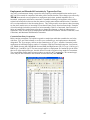
1
Users Manual
TELUM (Transportation Economic
and Land Use Model)
Version 5.0
March 2005
Table of Contents
1. Introduction to TELUM
1. Overview of the TELUM Manual...................................................................... 1.1
2. What can you do with TELUM?........................................................................ 1.2
3. Introduction to Integrated Transportation and Land Use Modeling ............ 1.2
4. TELUM Basics..................................................................................................... 1.3
Operating System .............................................................................................. 1.3
Tutorial.............................................................................................................. 1.4
Hyperlinks......................................................................................................... 1.4
Mouse Overs ..................................................................................................... 1.4
Information Tips ............................................................................................... 1.5
Comment Boxes ................................................................................................ 1.5
HELP................................................................................................................. 1.5
5. Flow of the TELUM System ............................................................................... 1.5
6. Land Use Modeling – An Overview .................................................................. 1.6
7. Forecasting with TELUM................................................................................... 1.8
2. Installation
1. Set Up .................................................................................................................. 2.1
System Requirements........................................................................................ 2.1
Overview of New TELUM Installation ............................................................ 2.2
Overview of an Upgrade to an Existing TELUM Installation .......................... 2.2
Running SETUP.exe ......................................................................................... 2.3
2. Configuring TELUM .......................................................................................... 2.4
Username Settings............................................................................................. 2.5
3. How to Change or Move your TELUM Project ............................................... 2.5
Circumstances Requiring a TELUM Reinstallation
3. Tutorial
1. Introduction ........................................................................................................ 3.1
How to use this Tutorial.................................................................................... 3.1
2. Initial Data Entry Unit....................................................................................... 3.1
Install TELUM .................................................................................................. 3.1
Enter TELUM username and password ............................................................ 3.2
Start your TELUM project ................................................................................ 3.2
Review and Enter Regional Data ...................................................................... 3.2
3. Data Organization and Preparation Unit and MAP IT................................... 3.5
Work in the DOPU Workbook ......................................................................... 3.5
Enter your Rancho Carne DOPU Data....................................................... 3.5
Check your Data Consistency Results........................................................ 3.7
MAP IT- Check zones and Data check ....................................................... 3.8
Launch MAP IT .......................................................................................... 3.8
4. Travel Impedance Preparation Unit................................................................. 3.9
TIPU Impedance Data Inputs............................................................................ 3.9
5. Model Calibration and Preparation Unit......................................................... 3.10
Run Employment and Household Model Calibrations ..................................... 3.10
Review the Calibration Analysis of Results and MAP IT ................................. 3.11
Run a Land Consumption Regression Model .................................................. 3.12
Explanation of LANCON findings ................................................................... 3.14
6. Model Forecasting Unit...................................................................................... 3.14
Prepare Files for a Forecast Model ................................................................... 3.14
Run a Baseline Model Forecast .................................................................. 3.14
Rerun a Model Forecast .................................................................................... 3.15
Run a Policy Model Forecast ............................................................................ 3.16
MAP IT- Map and Compare Forecast Results................................................... 3.17
4. Data Preparation
1. The TELUM Process........................................................................................... 4.2
2. Data Requirements for Agency Applications................................................... 4.3
Region-Level Requirements.............................................................................. 4.3
Spatially Disaggregated (Zonal) Requirements ................................................ 4.3
3. Preparation of Data Inputs for IDEU............................................................... 4.5
Geographic Detail ............................................................................................. 4.5
Temporal Detail.......................................................................................... 4.6
Sectoral Detail ............................................................................................ 4.6
Employment Data ............................................................................................. 4.6
Household and Population Data........................................................................ 4.7
Land Use Data................................................................................................... 4.7
Checking the Consistency of the TELUM -RES Land Use Variables ............. 4.8
Formulas for Unusable, Useable, and Vacant Land Variables ................... 4.8
Translating From Local Land Use Inventory Categories to TELUM-RES 4.9
4. Data Organization and Preparation Unit (DOPU).......................................... 4.9
Employment Worksheet.................................................................................... 4.10
Household Worksheet ....................................................................................... 4.11
Land Use Worksheet ......................................................................................... 4.12
Projections Worksheet ...................................................................................... 4.13
The Employment-to-Households Conversion Matrix ....................................... 4.13
5. Data Check and Consistency Report ................................................................ 4.16
6. Appendix for Data Preparation ........................................................................ 4-17
5. Map It
1.
2.
3.
4.
5.
What you can do with MAP IT ............................................................................. 5.1
How to run MAP IT .............................................................................................. 5.1
What can MAP IT do for you? ............................................................................. 5.1
What if you do not have ArcView 8x mapping software? ................................... 5.3
Building a Shapefile ............................................................................................. 5.3
6. Travel Impedance Preparation
1. Introduction to the Travel Impedance Preparation Unit ............................... 6.1
2. How to Organize your Travel Impedance Data............................................... 6.1
Organize your IMPD.txt File ............................................................................ 6.2
Create the IMPD.txt .......................................................................................... 6.2
Enter your IMPD.txt File into TELUM ............................................................ 6.2
Complete the Travel Impedance File Check ..................................................... 6.3
3. Future Year Travel Impedance......................................................................... 6.3
How to Add Future Year Travel Impedance..................................................... 6.3
7. Model Calibration
1. Introduction to Model Calibration ................................................................... 7.1
2. Starting Model Calibration – File Check ......................................................... 7.1
3. Begin Model Calibration – Employment and Household Location ............... 7.1
4. Analysis of Results for Model Calibration ....................................................... 7.1
Analysis of MAPE and MARMO Results ........................................................ 7.2
Analysis of Location Elasticity Results ............................................................ 7.2
5. Land Consumption Calibration (LANCON) ................................................... 7.3
How to Run a LANCON Calibration Regression ............................................. 7.3
Calibration Output Files.................................................................................... 7.3
6. Model Calibration Appendix............................................................................. 7.4
Model Calibration and Goodness-of-Fit Theory............................................... 7.4
Asymptotic t-Statistics in DRAM and EMPAL Calibrations ........................... 7.5
TELUM -RES Location Elasticity Values........................................................ 7.5
TELUM -EMP Location Elasticity Values ...................................................... 7.6
TELUM -EMP Sample Calibration Outputs .................................................... 7.8
8. Model Forecasting
1. TELUM Program Overview .............................................................................. 8.1
2. Model Forecasting Unit Overview .................................................................... 8.2
3. The Baseline Forecast ........................................................................................ 8.3
Running a Baseline Model Forecast ................................................................. 8.3
Re-run a Baseline Model Forecast .................................................................... 8.4
4. Running a New Model Forecast ........................................................................ 8.4
How to Re-run a New Baseline Model Forecast............................................... 8.5
Changing your Model Forecast Inputs .............................................................. 8.5
Making Use of Unobserved Factors in Forecasting .......................................... 8.6
5. Appendix ............................................................................................................. 8.7
The Employment and Household Location Model Formulations ..................... 8.7
The Residential Location Model - TELUM-RES............................................. 8.7
Review of the TELUM Model Forecasting Process ......................................... 8.9
Model Forecasting Output Files........................................................................ 8.9
TELUM-EMP Sample Forecasting Outputs..................................................... 8.10
1. Introduction to TELUM
Introduction to TELUM
Welcome to TELUM
This manual is intended to assist a new user of TELUM in learning to make efficient use of its many
capabilities. The manual contains a brief introduction to the history of the system, along with detailed
instructions for using TELUM. In order to obtain useful and correct forecast results, and in order to
minimize disruptions to the health of your computer operating system, it is imperative that users (this
means you) follow this manual closely. This system links to Microsoft’s Excel, to Microsoft’s Access, to
other system utilities such as Wordpad, and to ESRI’s ArcView, as well as to system components for
Visual Basic and for FORTRAN computing languages. For your ease of use, there are over 500 User
Interface Screens along with all the computer code to connect them. Successful installation and use of a
system this complex REQUIRES that you read and follow the instructions carefully.
1. Overview of the TELUM Manual
This manual is organized in the following manner. You will find it useful to read each chapter thoroughly
before starting the corresponding section of TELUM.
1. Introduction
History and Basics of TELUM
2. Installation
Setting Up and Configuring TELUM on
Your Computer
3. TELUM Tutorial
Running a Sample Forecasting Project to Provide
Familiarity and Experience in Using TELUM
4. Data Preparation
Gathering, Formatting, and Entering
Regional and Zonal Data
5. MAP IT
Using GIS to Analyze and Forecast Results
6. Travel Impedance Preparation Unit
Format and Input of Travel Impedance Files
7. Model Calibration
Checking Data, Estimating Equation Parameters,
and Explaining Calibration Results
8. Forecasting
Explaining the Forecasting Process, Implementing
Baseline and Policy Forecasts
TELUM
INTRODUCTION
2. What can you do with TELUM?
TELUM is an integrated interactive system that can be used to assist in evaluating the effects of a region’s
planned transportation improvement projects. It may also be used to make long term forecasts of a
region’s spatial patterns, as well as to produce forecasts which address the transportation and land use
consistency that is required as input to the air quality estimates now required by the CAAA and TEA21
(and ISTEA before that). TELUM uses current and prior residential, employment, and land use data to
forecast the future locations of each of those by employment sector, household income group, and land
use type. The interrelationships between transportation and land use can be just as important, and in some
cases more important, than the individual direct consequences of either. Having articulated a framework
for examining, analyzing, or understanding the transportation and land use interactions, it then becomes
possible to consider the consequences of a wide assortment of different kinds of policies. This includes
policies that attempt to achieve their aims by changes on the demand side, in terms of urban design and
land use control, as well as those that attempt to achieve their aims by acting on the supply side in terms
of various kinds of transportation improvement. These transportation improvements can be for highways,
transit or combinations thereof, as well as in increases in utilization efficiency of existing facilities.
3. Introduction to Integrated Transportation and Land Use Modeling
With Federal Highway Administration sponsorship in 1971, Professor Stephen H. Putman began the
development of what became known as the Integrated Transportation and Land Use Package – ITLUP.
The specific intent of that package was to provide a means to properly represent the interrelationships of
transportation and land use. The original package, developed in a university setting, was able to
demonstrate the general importance of these linkages, which were previously overlooked in transportation
policy analyses. Another result of that work was the inclusion, in the early 1980s, of a portion of the
package as part of the final release of the Federal Highway Administration's Urban Transportation
Planning System - UTPS software package.
In succeeding years, extensive upgrades, revisions, and modifications were made to all portions of
ITLUP. All or portions of the integrated transportation and land use package have been applied in more
than twenty different metropolitan areas in the United States, as well as in cities overseas. In the thirty
years that have passed since the first work on ITLUP, there has been a transformation in computer
technology that was quite unimaginable in 1971. Perhaps nowhere is this more true than in the
development and adoption for agency use, of Geographic Information Systems – GIS. In the summer of
1997, METROPILUS, a new land use modeling system, was first applied in an operating agency. The
new system, like its predecessor ITLUP, contained several models for location analysis, as well as
software, or links to external software for all the necessary data analysis, statistical analysis, and display,
including mapping, of outputs and results. In addition, the components of the package could be applied as
separate models, and also could be connected to other models currently in use by a student or a planning
agency for forecasting and analysis tasks. The entire modeling system, along with numerous utility
programs as well as Graphical User Interfaces – GUIs, was embedded in ESRI’s popular ArcView GIS
operating environment.
Beginning in 1999, Professor Putman embarked on a five-year U.S. Department of Transportation
sponsored project to retool METROPILUS as a land use component for the Transportation Economic
Land Use System (TELUS). The TELUS Land Use Model (TELUM) evolved from the earlier
METROPILUS work to become a self contained, novice-friendly land use modeling system designed to
project the location of new residential and nonresidential development based upon analysis of (1) prior
and existing residential and nonresidential development, (2) the location of transportation
improvement(s), and (3) overall congestion in the system. TELUM forecasts the location and amount of
1.2
TELUM
INTRODUCTION
household and employment growth for up to 30 years, information needed by an MPO’s external traveldemand-forecasting models to estimate network flows and subsequent congestion induced changes in
travel times.
It is important to understand that within TELUM the DRAM and EMPAL models borrowed from
METROPILUS and now known as TELUM-RES and TELUM-EMP, constitute only a portion of a
complete regional transportation, location, and land use model system. Such a system would involve
location and land use allocation models as well as a set of transportation analysis models including the
steps of trip generation, trip distribution, mode split, and trip assignment. All of the agencies making use
of TELUM are expected to have their own transportation analysis software already installed and
operational. The outputs of TELUM then become the inputs to the agency's own travel demand models
and trip assignment package (e.g. EMME2, MINUTP, TRANPLAN, TRANSCAD, UTPS, etc.). The
congested network travel times and/or costs produced as output from these packages may then be used as
inputs to subsequent time period forecasts from TELUM.
Most planning professionals have a good, intuitive sense of how employment and household location
patterns develop over time, and how those patterns are affected by changes in transportation systems.
Human intuition cannot, however, encompass all the thousands of data items and interactions that
describe transportation, location, and land use in a metropolitan region. Computer models such as
TELUM can both process this data in a consistent fashion, and, by making explicit much of the intuitive
understanding of these phenomena, effectively describe these important interactions. In addition, both
TELUM-EMP and TELUM-RES contain provisions for user augmentation of forecasts. This can be done
by use of constraints on activity location, which will be described in this manual. Furthermore, and of
particular importance here, by altering inputs to the models in order to represent policy assumptions,
policies can be evaluated by the same data-rich, replicable, and behaviorally consistent process.
4. TELUM Basics
In this document we describe the components of TELUM, how to organize a data set for your region, how
to use the data with the software, and how to interpret the results obtained.
In the manual font styles are used to indicate whether
directions refer to menu items, directory names, file
names, Excel spreadsheets, or command buttons. In the
box to the right are samples of how these font styles are
used.
Naming instructions for the files you create will be
covered in each relevant section of the manual.
Pull-down>pull-down sub-item
Button
DIRECTORY NAME
FILENAME
Excel Worksheet
Before you begin using the TELUM application, you
should know some of the program features available to you. These features are built in aids that help you
work through the model preparation and forecasting without having to always refer to this manual.
Operating System
TELUM, HELP, and the User Manual assume that you are proficient in the use of the Windows operating
system. If you need help with the operating system, please consult its user documentation or appropriate
technical support personnel in your organization.
1.3
TELUM
INTRODUCTION
The following sources of information are designed to help you successfully navigate the TELUM system:
1. Tutorial
On your TELUM CD-ROM you will find a folder labeled TUTORIAL containing all the files you will
need to produce forecasts for a sample 20-zone region in TELUM. We strongly recommend you use the
Tutorial to become more familiar with the system and its data requirements. A guide to the Tutorial is
provided in this manual in chapter 3.
2. Hyperlinks
Hyperlinks are blue underline texts that provide additional ways to present more information about
TELUM features. Once you have clicked a hyperlink, TELUM will automatically turn the underline text
purple to indicate that you have already visited the text link. Print buttons are often provided with the
hyperlinks in case you need a printed copy of the information for use at a later date.
3. MouseOvers
MouseOvers are tips that pop up when the mouse pointer is paused over a text feature. Currently this
feature is only used in the TELUM MAIN screen and MAP IT.
1.4
TELUM
INTRODUCTION
4. Information Tips
i
Information Tips are small buttons labeled with found inside the TELUM DOPU Data Preparation
workbook. By clicking on the information button, TELUM pops up a small text box that describes the
data requirements of the tables.
5. Comment Boxes
Comment Boxes are small red triangles that appear in the upper right corner of the TELUM DOPU Data
Preparation workbook (spreadsheet). Comment boxes pop up when the mouse pointer is paused over a
cell with a red triangle.
6. HELP
This feature is currently under construction. In the future, you will be able to access this manual and
troubleshooting information from an internal TELUM file.
5. Flow of the TELUM System
To complete a full set of model forecasts for your region you must work through the TELUM system in
the following order: IDEU, DOPU, TIPU, MCPU, MFCU. Once you have successfully completed each
section you may move between modules to do additional work. These modules are designed to gather,
organize, calibrate, and forecast your regional employment and households.
1.5
TELUM
INTRODUCTION
In the following section we provide an overview of land use modeling and how TELUM can be used in
your region. While this background information is not required for running the TELUM system, you may
find these sections informative.
6. Land Use Modeling: Overview
Phenomena as complex as the location of jobs and people in a large region require complex analysis tools.
In recent years a number of regional planning agencies in the US have carried out the process of
implementing forecasting models of employment and household location and land use, both for the
purpose of doing forecasts and policy analyses, as well as for the purpose of providing inputs to their
transportation and air quality modeling efforts.
The overall approach, as embodied in a package of computer programs and procedures, involves several
major components. These are (1) first, procedures for forecasting the spatial location of employment and
households in a metropolitan region, (2) second, a procedure for using these location forecasts to produce
a set of origin destination trip matrices, (3) third, a procedure, when appropriate, for doing mode-split
analysis, (4) fourth, a procedure for assigning (in most cases only highway) trips to a capacity-constrained
highway network and (5) fifth, a set of procedures for linking the congested travel times back to the
employment and household forecasting procedures.
Such an approach, overall, is the only one that allows for explicit representation, analysis and
evaluation of the effects on traffic congestion and transportation efficiency resulting from changes in
urban design and land development patterns, in combination with variations in socio-economic factors.
Decades of transportation and land use studies of every sort have shown us clearly that there are
relationships between transportation and land use or land development. However, if we look over all these
many studies, it is sometimes very difficult to understand how the varying results can be considered
logically consistent.
One important result from the integrated transportation and land use package development was that its
overall construct provided a clear way to see that often the apparently conflicting results from
transportation and land use studies were in fact conflicting only because of the way in which they were
initially viewed. The most obvious example is in some of the traditional approaches to solving local
congestion problems. In such cases a study will be done of a physical transportation facility and a need
will be defined for increased capacity of one sort or another on the network. This capacity, an additional
highway lane, a new road, etc., will be constructed and will result, in the short-term, in an improvement of
vehicle flow and a reduction in the observed congestion. Unfortunately, in the long-term, such strategies
often have just the opposite result. The increased network capacity is used by trip makers to make more
trips and/or longer trips. Thus, in the long-run, it has often been the case that an improvement in a
transportation system, most frequently in terms of highway construction, while having a short-term effect
of improving the situation for travelers, has a long-term effect of doing just the opposite. Indeed, one of
the consequences of highway construction in the absence of demand management or urban design in an
attempt to in some way regulate land use and land development has been to spread greater network
congestion over a larger number of links in the network.
The traditional transportation planning approach makes it very difficult to anticipate these kinds of
system responses to particular policies. In this analysis process, a series of externally produced estimates
of trip demands, usually in the form of origin-destination trip matrices, is calculated using exogenously
estimated sets of socio-economic data. So, for example, let us consider an agency preparing in 2004 longterm transportation plans for the year 2030 or 2040 or beyond. In such a case, typically a series of socioeconomic forecasts, in terms of employment locations and household locations spatially distributed over a
1.6
TELUM
INTRODUCTION
large region would be prepared first. These would be based upon information about the highway system
that the region was expected to have, though in fact, there would be, even at this early stage in the
process, an inconsistency because the system that the region would be expected to have would show
different characteristics to users as a function of what the users were doing about using the system, i.e. the
traffic flows and congestion.
In any case, a set of forecasts would be developed and then, based on the forecasts of the location of
employment and households, a set of estimates would be made of the number of trips originating from
each zone and terminating in each zone. Then, a trip distribution procedure would be implemented that
would calculate the number of trips going from each particular origin zone to each particular destination
zone in the region. These trips would then be assigned to the links of the proposed highway network. Any
of a variety of trip assignment algorithms might be used. The intention of any of them would be to
calculate how many trips would travel across each of the individual links in the highway network. Then,
based on the number of trips using each link, an estimate would be made of the congestion: the increased
time or cost that would be experienced by each of the users of that particular link in the network.
Once these congestion levels have been calculated for all of the links in the network, it becomes
possible to trace the minimum cost paths from each zone to each other zone over the congested network.
Looking at these minimum cost paths as well as the congestion levels on individual links of the system,
the conventional analysis procedure would then identify links that should have capacity increases, which
normally would be accomplished by construction or modification of one sort or another. After these links
have been identified, construction projects could be described and budgeted and the analysis would be
completed in the form of a set of recommendations as to places where the network could be improved.
The defect in this procedure is that the congestion that results from the initial estimates of trip makers
and thereby from the initial estimates of the locations of employment and households would, in and of
itself, result over a long-term span of years, since forecasts traditionally are concerned with a rearrangement of the locations of employment and households. Thus in order to properly estimate the
congestion it is, in effect, necessary to know the congestion. In order to properly know the congestion, it
is necessary to know the location of employment and population and the resulting demand for trip flow on
the network and so on and so forth. This is a classical example of a system that can only be properly
analyzed by use of an interactive technique that includes both the direct and the indirect connections or, as
is sometimes described, both the feed-forward and the feed-back connections amongst the elements of the
system.
A complementary system to this one is traditional land use or urban design analysis. In such a case,
descriptions of the transportation system, which may include highway as well as transit, are taken from
exogenous sources. That is to say, somewhere someone will provide an estimate of the zone-to-zone
travel time and travel cost on various modes that a user might experience, let us say in the year 2010 or
2020. Based on these estimates, as well as on base year data regarding the initial locations of employment
and households, and on a set of regional forecasts of total employment and total households, a calculation
can be made that will estimate their location in the zones of the region. Often, a whole series of such
forecasts will be made, at five- or ten-year intervals from some base year, out to some long-term planning
horizon.
The defect in this approach, which is analogous to the defect in the traditional transportation planning
approach, is that no cognizance is given to the fact that the locations of employees and households will,
by virtue of the trips necessary to interconnect them, congest the network. The congested network times
will, in most cases, be somewhat if not significantly different from the initial estimates of the network
times. What is needed is an interactive procedure that includes both the effects of the location of
employees and households on the transportation system as well as the variation of the location of
1.7
TELUM
INTRODUCTION
employees and households caused by congestion-induced changes in the transportation system
characteristics.
It is precisely this integrated interactive process that the original ITLUP model system was designed to
properly represent. It is this transportation and land use consistency that is required as input to the air
quality estimates now required by the CAA and TEA21 (and by ISTEA before that). Even the earliest
tests of ITLUP, done nearly 20 years ago, showed that the interrelationships between transportation and
land use can be just as important, and in some cases more important, than the individual direct
consequences of either set of phenomena. Having articulated a framework for examining, or analyzing, or
understanding the transportation and land use interactions, it then becomes possible to consider the
consequences of a wide assortment of different kinds of policies. For the first time, this included policies
that attempt to achieve their aims by changes on the demand side, in terms of urban design policies, land
use control policies, and the like, as well as policies that attempt to achieve their aims by acting on the
supply side in terms of various kinds of transportation improvements, either in highways or transit or
combinations thereof, as well as in access and increases in utilization efficiency of existing facilities.
7. Forecasting with TELUM
Land use forecasting is best done in time increments (usually of five years length), as this acknowledges
the difficulties of obtaining data for any more detailed set of intervals, while at the same time allowing for
some amount of adjustment of employment, residence, land use, and transportation forecasts in response
to each other within these intervals. Each increment would begin with the execution of TELUM-EMP.
The model is normally used for 4 to 8 employment sectors with individually estimated parameters. To
forecast the location of employment of type k in zone j at time t+1, TELUM-EMP uses the following
input variables:
•
•
•
•
Employment of type k in all zones at time t
Population of all types in all zones at time t
Total area per zone for all zones
Zone-to-zone travel cost (or time) between zone j and all other zones at time t.
Following the employment location forecasts produced by TELUM-EMP, TELUM-RES automatically
produces a set of residence location forecasts. This model is normally used for 4 to 5 household types
(usually income groups) with individually estimated parameters. Then, the land use submodel, LANCON,
calculates land consumption, making a simple reconciliation of the demand for location by employers and
households with the supply of land in each zone. To forecast the location of type h residents in a zone at
time (t +1) TELUM-RES uses the following input variables:
•
•
•
•
•
•
Residents of all h types in zone i at time t (the previous time period)
Land used for residential purposes in zone i at time t
The percentage of the developable land in zone i that has already been developed at time t
The vacant developable land in zone i at time t
The zone-to-zone travel cost (or time) between zone i and all other zones at time t+1
Employment of all k types in all zones at time t+1.
The residence and employment location forecasts produced by TELUM may then be used (sometimes
after a further step of spatial disaggregation) as input to travel models that generate and distribute trips,
split trips by mode, and then assign vehicle trips to the transportation network(s), and calculate
congestion.
1.8
TELUM
INTRODUCTION
So, for example, one could take the outputs of TELUM and use these as inputs to the trip generation
and distribution components of some standard transportation planning model package. Having completed
the assignment of trips to the network using this package, one could calculate the minimum paths through
the network. If multiple modes are being analyzed, the minimum times through the networks via these
different modes are calculated. They would be combined in a composite cost calculation and then the
composite cost estimates of zone-to- zone composite travel times or travel costs would be taken and used
as inputs to the recalculation of employment and household location in TELUM.
Many different configurations of land use and transportation linkages have been tested using ITLUP
and METROPILUS. While the current implementation of the TELUM model system does not permit all
of these configurations to be examined, there is adequate scope, in an agency setting, for preparing an
accurate baseline forecast, which can be used as inputs to the agency’s travel modeling system, as well as
for making forecasts of the consequences of various possible policy alternatives. Throughout this manual
we present a mix of theory discussion with instructions for specific model operation. Our intent is to
enable thoughtful users to make effective use of this powerful analysis tool. In the next chapter we
provide information on installing TELUM, and follow this with a description of data requirements for use
of these models. We then provide detailed instructions for the preparation of a small test data set to be
used for the education of students and new users.
1.9
2. Installation of TELUM
1. Setup
System Requirements
It is imperative that the user follows these setup instructions closely. We cannot over emphasize the
importance of this preliminary check and setup of your computer. Deviation from these instructions will
cause your computer and TELUM to malfunction. To aid your successful installation of the TELUM
system, use the following checklist.
Please review the list and confirm that everything is in order on your computer before you start the
TELUM installation. We cannot overemphasize the importance of this preliminary check and setup of
your computer. A successful TELUM installation depends on the following:
•
Your computer must be equipped with a registered Windows 2000 (with the upgrade to Service Pack
5) or Windows XP (with Service Pack 2), and you must have the Microsoft Office software package,
including full installation of Microsoft Access and Microsoft Excel.
•
Microsoft Excel must include both the Analysis ToolPak and the Analysis ToolPak-VBA extensions.
Please load these extensions before installing TELUM. Directions are provided below. Please note
that some computer installations, especially in the case of networked systems have these extensions
setup to be uninstalled when the user turns off their PC or even in some cases if they “log off” the
network. You will need to be sure that they are present prior to each use of TELUM.
[Open an Excel workbook, Go to Tools → Add-Ins, click on Analysis ToolPak AND Analysis
ToolPak-VBA]
Note: You might need to use your Microsoft Office CD-ROM in order to install these extensions.
Please contact your systems administrator if you are experiencing problems loading these extensions.
•
Microsoft Excel must be set on “Low” Macro Security whenever you are running your TELUM
project.
[Open an Excel workbook, Go to Tools → Macro → Security, select “Low”]
•
ESRI ArcGIS must be installed on your computer in order to use TELUM mapping module called
MAPIT. Current version of TELUM is compatible with ArcGIS versions 8.3 and 9.x.
TELUM
INSTALLATION
•
In addition to desktop installation of ArcGIS you also must install ArcGIS Developer Kit (versions
8.3, 9.0 and 9.1) or ArcGIS Desktop SDK for Visual Basic (versions 9.2). This is necessary as some
of the ArcGIS scripts and software libraries used by TELUM are not installed with the ArcGIS basic
desktop installation.
•
If you do not have ArcGIS or you do not have a version of ArcGIS compatible with TELUM installed
on your computer, you can not use MAPIT module. Please select “No” when prompted by MAP IT.
The embedded GIS procedures of TELUM will only run with above versions of ArcGIS, though you
can export completed calibration and forecasting data from TELUM after completing the runs and use
them in other GIS software.
•
Land use data values are to be in the unit of acres only.
•
When prompted by TELUM, users are asked to place file(s) inside the TELUM project folder. Files
copied into TELUM must not have the “read only” property. Check file properties after you copy
them into TELUM folder, especially if you are copying them from a backup CD (many of which
automatically set file property to “read only”). To change the “read only” property, please follow the
instructions.
[Select the file(s), then right-click mouse on the file(s), go to Properties → General, and check if the
property “Read only” is selected. If it is, then unselect it and click “Apply“. Do the same with the rest
of the files you copied in TELUM.]
•
You should remove all former versions of TELUM prior to installing TELUM ver. 5.
BEFORE removing former versions of TELUM, you have the option to save the data that you have
already entered in TELUM’s Dataprep.xls spreadsheet. In order to do that you should save your old
dataprep.xls with a new name and in a different folder of your choice.
AFTER installing the new version of TELUM, and when you have gotten to the Data Organization
and Preparation Unit (DOPU) with your new dataprep.xls spreadsheet open, you will be able to
transfer your data using Copy and Paste Special → Values. Open the old (renamed) dataprep.xls
directly (outside of TELUM). At the prompt click “No”. The spreadsheet will open and you will be
able to access your data.
NEVER copy an old TELUM spreadsheet into a newer version of the program. The spreadsheets are
not compatible and will cause malfunctions in your project.
FYI, a safe way to uninstall former versions of TELUM is via the standard procedure that Microsoft
Windows offers, using the “Add/Remove Programs” option:
2.2
TELUM
INSTALLATION
[Go to Start → Settings → Control Panel → Add Remove Programs. Scroll down until you find
TELUM. Click on TELUM and then click on the “Change/Remove” button. In addition, go to
TELUM folder and erase the whole folder.]
How to Install TELUM
1. Once you have checked off ALL of the above TELUM project requirements, begin your installation
by double-clicking on the SETUP.exe.
2. If you are installing TELUM from TELUS CD, during installation TELUM will ask you to select
version of ArcGIS you are using. If you are using any of the 9.x versions, please select ArcGIS 9.0. If
you do not have ArcGIS installed on your computer, please select “I do not have ArcGIS 8.3 or
higher”. Click “Install” button after making the above selections.
OR
If you are downloading installation files from TELUS/TELUM website, please select installation
package that matches the version of ArcGIS that you currently have on your computer.
3. TELUM installation will begin automatically. Please follow the instructions on the screen.
4. At the conclusion of installation, your system will reboot automatically, unless you are using a
Windows XP operating system. With Windows XP a reboot is not necessary.
2.3
TELUM
INSTALLATION
Running SETUP.EXE
1. The program will prompt you to choose an installation directory. The default directory is
C:\TELUM. Click the Browse button to install the TELUM system on a different directory.
****NOTE: Please do not use any spaces in the name of the directory.
Correct: C:\TELUMNEW
Incorrect: C:\TELUM NEW
2.
If you click the Browse button, you will see a dialog box similar to the one below, which
allows the user to install TELUM into an alternate directory:
2.4
TELUM
INSTALLATION
3. The installation package will then prompt you to select Full or Patch installation. For a new
TELUM installation, you must select “Full.” A “Patch” is only used for system upgrades.
4.
Installation will be completed a few seconds after your component selection is made.
5. Your project filename will be, by default, TELUM.EXE.
After installation, a shortcut to TELUM will be added to your computer as a Desktop icon. Your system
will reboot automatically, unless you are using a Windows XP operating system, in which case a reboot is
unnecessary.
2. Configuring TELUM
To open your project, go to the Desktop and locate the TELUM icon for your project. When you doubleclick the TELUM icon you will see this screen:
2.5
TELUM
INSTALLATION
Username Settings
When you open your TELUM project for the first time, you will be prompted to create a username and
password. At this time, this function is set with a default username and password. When prompted enter
you will need to enter username and password in order to start the application. To obtain the username
and password, please contact TELUM user support or FHWA Resource Center (please refer to Section 4.
User Support (below) for contact information).
3. How to Change or Move Your TELUM Project
With an installed version of TELUM on your computer you can begin land use modeling activities for
your agency. If at any time you should decide to change or move your agency project you must re-install
TELUM onto another computer. If you decide to reinstall TELUM on a machine where you are currently
running a TELUM project, it is imperative that you rename your old TELUM folder or modify the name
of the new folder. Otherwise TELUM will reinstall itself over the existing C:\TELUM folder and the
resulting file mismatches will render both the original and new versions of TELUM inoperable.
Circumstances that require a TELUM Reinstallation
The following types of project change cannot be accomplished within an existing TELUM project. To
change any of the following, you must reinstall TELUM.
1. The number of zones increases or decreases.
2. The number of employment and/or household categories increase, decrease, and/or change
names.
3. Your agency builds a new regional GIS shapefile for your TELUM project.
4. Your TELUM project is being relocated to a different computer.
Once installation has been successfully completed, we strongly recommend the you run through the
Tutorial section in Chapter 3 to familiarize yourself with the data entry and program requirements. This
tutorial offers valuable practice and will reduce the danger of errors in your forecast. Based on extensive
testing, it is extremely unlikely that you will be able to successfully complete a forecast without the
operating skills gained through running the TELUM Tutorial.
Instructions for installing the TELUM Tutorial are covered in the next chapter of the manual.
4. User Support
For user support please visit TELUS website at www.telus-national.org. If you are an MPO, State DOT,
or other public transportation or planning agency in the United States you can also contact TELUS
development team:
Transportation, Economic and Land Use System (TELUS)
New Jersey Institute of Technology
Tiernan Hall, Suite 287
University Heights
Newark, NJ 07102
E-mail: [email protected]
Phone: (973) 596-5700
Fax:
(973) 596-6454
2.6
TELUM
INSTALLATION
If you are not an MPO, State DOT, or other public transportation or planning agency in the United States,
please contact Federal Highway Administration (FHWA) Resource Center for more information about
user support for TELUM:
FHWA Resource Center
Lisa Randall
Planning Technical Service Team Leader
12300 West Dakota Avenue Suite 340
Lakewood, CO 80228
Phone: (720) 963-3209
Fax:
(720) 963-3232
[email protected]
2.7
3. TELUM Tutorial
Tutorial Contents:
1. Introduction
2. Initial Data Entry Unit (IDEU)
3. Data Organization and Preparation Unit/ MAP IT (DOPU)
4. Travel Impedance Preparation Unit (TIPU)
5. Model Calibration and Preparation Unit (MCPU)
6. Model Forecasting Unit (MFCU)
1. Introduction
Welcome to the TELUM Tutorial. This tutorial is a 20-zone student TELUM project for Rancho Carne, a
fictitious California coastal region. Please use this document and the accompanying data inside the
Tutorial folder to walk-through the Rancho Carne project. The Tutorial folder is located on your TELUM
CD-Rom. This data set was originally developed by Daniel Schack and Leah Wright as one of the
requirements for a course on Urban Simulation Modeling taught by Dr. Putman. It has since been
modified to improve its teaching function.
How to use this Tutorial
This tutorial is intended to provide an overview of TELUM as well as practice in data entry and output
comprehension. The Tutorial folder contains all the files and data you will need to complete a calibration
and a set of model forecasts for the Rancho Carne region.
As you work through this project hyperlinks are available to help explain the various functions and data
inputs more thoroughly than you will see here. Throughout this tutorial you will see screen numbers used
to refer to various sections of the TELUM software. These screen numbers are located in the lower left
corner of each TELUM screen. (e.g. P3.15.1) If you have a question or concern while you are working
with TELUM, you must record the screen number where the problem occurred. Referencing a screen
number improves the TELUM staff’s ability to respond to your question or concern in a timely manner.
After you have completed this tutorial you will be better prepared to build and run a TELUM project for
your region.
2. Initial Data Entry Unit (IDEU)
In this section you will do the following:
1. Install TELUM
2. Enter your TELUM username and password
3. Start your TELUM project
4. Review and enter regional data
1. Install TELUM
Begin by performing a TELUM installation, as described in Chapter Two of this manual.
TELUM
TUTORIAL
2. Enter TELUM Username and Password
Once you have completed the installation process, a TELUM icon will appear on your computer’s
desktop. Double-click on the TELUM icon. Upon entering TELUM, the program will prompt you to enter
your username and password. To obtain the username and password, please contact TELUM user support
or FHWA Resource Center (please refer to Chapter 2, Section 4. User Support for contact information).
3. Start your TELUM project
After a series of welcome screens, the opening screen appears with a number of colorful buttons. These
buttons later allow you to skip directly to different sections of the TELUM system. You will only use
these buttons later, when you click “EXIT” in TELUM and subsequently wish to return to the section in
which you stopped working. However, at this point, your first time through, you must begin by clicking
on “CONTINUE” to enter the Initial Data Entry Unit (IDEU).
4. Review and Enter Regional Data
IDEU is where you provide TELUM with the basic information the system will need to organize your
region’s data. The purpose of IDEU is to help you prepare the data you will need in the next component
of TELUM, DOPU. Listed below are the TELUM data requirements for IDEU. The last column contains
sample data you will use to run your tutorial session.
Enter Your Rancho Carne IDEU Data
The sample data inputs below contain employment and household activity name abbreviations for the
Rancho Carne region. Employment and household activity name abbreviations will vary from one
TELUM project to another. The definition of each abbreviation follows the table below:
3.2
TELUM
TUTORIAL
Screen
TELUM IDEU Data Categories
Sample Data for
Rancho Carne, CA
P2.3
Name of your Region
RC
P2.4
Number of Zones
20
P2.4
Total Regional Population
62819
P2B.7 Current Data Year
2000
P2B.7 Lag Data Year
1995
P2B.8.1 Number of Employment Categories
5
Name of Employment Category 1
AGR
Name of Employment Category 2
LMFG
Name of Employment Category 3
PROF
Name of Employment Category 4
RTL
Name of Employment Category 5
FIRE
P2B.9.1 Number of Household Categories
4
Name of Household Category 1
LI
Name of Household Category 2
MI
Name of Household Category 3
UMI
Name of Household Category 4
UI
P2B.12 Total Land Area of Region
P2B.12.1 Total Land
Usable Land
Unusable Land
Land Used for Basic Employment
Land Used for Commercial Employment
Residential Land
Streets
Vacant Developable
P3.13.1 Number of Forecast Time Periods
184,332
Available
Available
Available
Available
Available
Available
Available
Available
6
Employment to Household Conversion
P3.15 Ratio
PUMS Ratio
P3.16.1 Employment per Household by Income
EHIC Ratio
P3.17
Unemployment
UR Ratio
P3.18
Net Commutation Rate
P3.19
Regional Jobs per Employee
3.3
RNCR Ratio
Select “Do Not Know”
TELUM
TUTORIAL
RC- Rancho Carne
AGR- Agriculture
LMFG- Light Manufacturing
PROF- Professional/Scientific/and Management
FIRE- Finance/Insurance/and Real Estate
LI- Low-income Households
MI- Middle-income Households
UMI- Upper Middle-income Households
UI- Upper-income Households
PUMS- Public-Use Microdata Sample
EHIC- Employees per Household by Income
UR- Unemployment Rates
RNCR- Regional Net Commuting Ratio
After entering your regional data, TELUM provides a summary report of the data you entered in IDEU,
as pictured below. Please compare this report to your data to ensure accuracy.
Figure 1- IDEU Initial Data Entry Unit Report
3.4
TELUM
TUTORIAL
3. Data Organization and Preparation Unit and MAP IT
In this section you will do the following:
1. Work in the Data Preparation Workbook
2. Check the consistency of the link between IDEU data and the GIS files in MAP IT
1. Work in the DOPU Workbook
You will enter zonal data related to the employment, household, and land use activity taking place in your
region. Zonal data for Rancho Carne is available in the RC_DOPU_DATA.xls file located in the Tutorial
folder.
Enter Your Rancho Carne DOPU Data
Upon entering the DOPU Workbook, you will be prompted to answer if this is your first time (or not)
entering DOPU module. For the purpose of this tutorial click on the “Yes” button.
Working with your DOPU Workbook
You may enter the Rancho Carne data into the TELUM DOPU Employment, Household, Land Use and
Projection Worksheets manually or by using the “copy” option.
***NOTE- The data will paste correctly only if you use the “paste special” options in Excel. Import data
from your worksheet using “paste special” as “values.”
You need to import data into the blue cells only in your DOPU worksheets. Once your data is correctly
imported, your zonal household, population, and employment numbers will appear in the worksheet.
An example of these worksheets as you will first see them before data entry into the DOPU workbook
follows:
Households: 2000
Population in
Group
Quarters
Total
Household
Population
2000
Average
Population
per
Household
2000
Zone
HH1
2000
HH2
2000
HH3
2000
HH4
2000
HH5
2000
HH6
2000
HH7
2000
HH8
2000
Total
Households
2000
1
0
0
0
0
0
0
0
0
0
0
0
0.000
2
0
0
0
0
0
0
0
0
0
0
0
0.000
3
0
0
0
0
0
0
0
0
0
0
0
0.000
4
0
0
0
0
0
0
0
0
0
0
0
0.000
5
0
0
0
0
0
0
0
0
0
0
0
0.000
6
0
0
0
0
0
0
0
0
0
0
0
0.000
7
0
0
0
0
0
0
0
0
0
0
0
0.000
8
0
0
0
0
0
0
0
0
0
0
0
0.000
9
0
0
0
0
0
0
0
0
0
0
0
0.000
10
0
0
0
0
0
0
0
0
0
0
0
0.000
Figure 2- TELUM DATAPREP – Households Worksheet for Current Year Zonal Data
3.5
TELUM
TUTORIAL
Population
Employment
Year
Total
Population
Employment Employment Employment Employment Employment Employment Employment Employment
Total
1
2
3
4
5
6
7
8
Employment
1995
0
0
0
0
0
0
0
0
0
0
2000
0
0
0
0
0
0
0
0
0
0
2005
0
0
0
0
0
0
0
0
0
0
2010
0
0
0
0
0
0
0
0
0
0
2015
0
0
0
0
0
0
0
0
0
0
2020
0
0
0
0
0
0
0
0
0
0
2025
0
0
0
0
0
0
0
0
0
0
2030
0
0
0
0
0
0
0
0
0
0
Household Size:
0.0000
Figure 3- TELUM DATAPREP – Projections Worksheet
***NOTE- The data will paste correctly as values only if you open both the DOPU Workbook and the
RC_DOPU_DATA.xls in the same instance of Excel. Do this by opening the DOPU workbook through
TELUM as instructed. Then open your regional data workbook from which you will paste your data by
choosing File>Open and browsing to locate the other file.
After pasting, save your DOPU Workbook and RC_DOPU_DATA.xls by clicking on File > Save.
After you have finished entering data into each of your DOPU worksheets, click again on File > Save.
There will be an X on the main worksheet next to each workbook name, as shown below.
Figure 4- DOPU Opening Screen
***NOTE- Please save and exit the RC_DOPU_DATA.xls file before running the DOPU Workbook
“Data Check.”
3.6
TELUM
TUTORIAL
The “Run Data Check Results” button inside the “Data Check” worksheet will then be enabled when
you click this button. TELUM will then run a consistency check of your data. In this report, TELUM will
highlight values that are not within the predefined ranges considered normal. We strongly recommended
that you review these reports and pay special attention to any highlighted values.
Check Your Data Consistency Results
The following chart contains the values we expect you will see as you view your DOPU Data
Consistency Check for Rancho Carne.
Screen
P4.30
Data Variable
Value
Correlations
Total Current vs. Lag Household Correlation
0.786
Total Current vs. Lag Employment Correlation
0.924
Total Household vs. Employment Correlation
-0.186
Total Household vs. Population Correlation
0.997
P4.30.1 Employment Correlations
AGR vs. AGR
0.830
LMFG vs. LMFG
0.946
PROF vs. PROF
0.921
RTL vs. RTL
0.967
FIRE vs. FIRE
0.926
P4.30.3 Consistency Check of Regional Ratios
Population per Household
2.5
Population per Employment
1.8
P4.30.2 Percentage Change
Households
10.2%
Employment
11.0%
Population
11.5%
Employment, Current to Forecast
2.6%
0
Land Use Check
If consistency results in the tutorial or later with your regional data show red text or a warning, this
indicates low or high correlations or percentage change in parameters. If this occurs, you should doublecheck your data entries and agency sources for accuracy. In the Racho Carne example, there is a low
correlation for total households vs. employment, as place of residence in this region do not correlate with
place of work.
3.7
TELUM
TUTORIAL
2. MAP IT - Check Zones and Data Check
If you have ArcView 8.3 installed on your computer system, you have access to TELUM MAP IT, a
mapping tool for visually displaying your data and your calibration and forecasting results. In this section,
TELUM will ask you if you wish to use MAP IT. If you select “No,” this will be the last time TELUM
presents MAP IT as an option.
If you should decide to use MAP IT later, you will need to revisit the TELUM DOPU section and select
the “Yes” option. If you select “Yes,” MAP IT will require a set of regional shapefiles inside the main
TELUM folder. Inside your Tutorial folder is a set of shapefiles for Rancho Carne, labeled ZONE.SHP,
ZONE.DBF, ZONE.SHP.XML, ZONE.SHX. Place these four files inside the main TELUM folder before
enabling the MAP IT function.
Launch MAP IT
TELUM begins MAP IT by instructing users to complete a mapping check, called “Check Zones.”
“Check Zones” is used to ensure mapping consistency. If they find their check zone maps to be
inaccurate, the user must correct the problem before this feature can be enabled for future use. MAP IT
will prompt you to “select the shapefile field that contains the zone number.” For your Rancho Carne
project, select the “ID” field.
***NOTE-If you do not select the “ID” field when prompted as you enter MAP IT for the first time, your
data will not map correctly.
You can change the appearance settings of your maps as desired. The following are examples of the
Highest Total Employment and Upper Middle Income Household Location maps from the Rancho Carne
data:
Figure 5- MAP IT Output 1
3.8
TELUM
TUTORIAL
Figure 6- MAP IT Output 2
When you have finished working in MAP IT, please exit ArcView to return to TELUM.
After you have viewed “Check Zones” in MAP IT, TELUM will prompt you to answer three questions
regarding your maps. For the purpose of this tutorial, please answer “Yes” to all of the “Check Zone”
questions.
4. Travel Impedance Preparation Unit
In this section you will prepare a Travel Impedance File. The term “impedance” refers to the travel time,
travel cost, or a composite of both, calculated by travel models not included in TELUM to describe
differences in zone-to-zone difficulty of interaction. An impedance file would typically be available from
your agency’s transportation department. TELUM provides steps and examples for converting an
impedance file for your TELUM project. For the Rancho Carne project, an impedance file is provided in
your Tutorial folder, labeled IMPD.txt. Place this IMPD.txt file inside your C:\TELUM\DATA folder if it
is not already there. Instructions for creating an IMPD.txt file with your regional data are provided in
Chapter 4, Data Preparation.
TIPU Impedance Data Inputs
The Travel Impedance Preparation Unit (TIPU) runs a data validation procedure on the contents of your
IMPD.txt file. In order to run this validation you must enter the following data into TELUM as you work
through the TIPU section.
3.9
TELUM
Screen
P5.30.3
P5.30.4
P5.30.5
P5.30.6
P5.30.7
TUTORIAL
TIPU Data Variable
Input Value
Average Impedance
Smallest Impedance
Largest Impedance
Top 4x4
87
7
197
10,
45,
31,
87,
45,
7,
30,
42,
31,
30,
8,
67,
87
42
67
23
14,
61,
39,
28,
61,
14,
34,
33,
39,
34,
28,
21,
28
33
21
29
Bottom 4x4
When you have completed these steps correctly, TELUM will search for the impedance file, verify its
contents, and display the frequency distribution of impedences by zone. You will then automatically be
escorted into the next section, MCPU.
5. Model Calibration and Preparation Unit
In this section you will do the following:
1. Run a Model Calibration
2. Review the Calibration Analysis of Results and MAP IT
3. Run a Land Consumption Regression Model
1. Run Employment and Household Model Calibrations
Model calibration is a process of estimating the model parameters (equation coefficients) to obtain a
match between observed and model estimate distributions of a region’s employment and household
location. The Employment and Household Model Calibrations are calibrated by use of non-linear
regression. TELUM will use your IDEU, DOPU, and TIPU inputs to run the model calibration. The
calibration is computationally intensive and may take up to 30 minutes to complete. Upon completion of
the employment and household calibration, TELUM immediately provides a calibration “Analysis of
Results” section.
3.10
TELUM
TUTORIAL
2. Review Calibration Analysis of Results
The Analysis of Results contains statistical measures used to describe the model’s fit to your data. The
better the fit of the model to the data, the more reliable the forecasts it can produce. An example of
calibration results for Observed vs. Estimated Employment Location for the Retail category of
employment follows:
Figure 7- MCPU Analysis of Results for Employment
3.11
TELUM
TUTORIAL
MAP IT also appears in this section for you to view your Calibration Residuals. Residual maps show
where the model over and under estimates the zonal location of employment and households in the
region. An example of MAP IT outputs for Low Income Household Residuals follows:
Figure 8- MAP IT Output 3
To explain the role of calibration residuals, let’s assume that a zone in Rancho Carne contains the
regional airport. The presence of the airport shows a concentration of employment. Under other
circumstances, a concentration of employment like this will cause an increase in household attraction,
which is not the case here because households are prohibited from locating near the airport. While the
model is unable to know zonal specifics, a user may be able to identify the model’s source of high over or
under estimation. A zone with a high over estimation of households, as discussed in this example, will
appear in the darkest gray scale shade. Zonal characteristics like this are important to document as they
can later be added as “local knowledge” to the model to modify zone attractiveness and thus improve the
accuracy of forecasts.
3. Run a Land Consumption Regression Model
The Land Consumption Model (LANCON) is the last section in the MCPU component. LANCON uses
your land use, employment and household data to forecast the change in the amount of land, by zone, that
will be used by each of these categories. LANCON calibration is done by use of linear multiple
regressions. Much like the employment and household calibration analysis, LANCON provides statistical
measures for your region’s land use data.
3.12
TELUM
TUTORIAL
At the startup of LANCON, the calibration (regression) procedure will ask you to enter the following:
1. Indicate for TELUM which employment categories in Rancho Carne are Basic. (Basic
categories are industries that produce goods.) For Rancho Carne please check AGR and
LMFG.
2. Indicate for TELUM which household categories in Rancho Carne are Low and High
Income. (Low and High incomes refer to households that fall in the bottom or top
quartile/quintile in the region, respectively.) For Rancho Carne please check LI as your Low
Income household category and UI as your High Income household category.
3. Execute LANCON by clicking on the LANCON button. This process takes time. Please wait
for the Continue button to become enabled before trying to proceed.
4. Your LANCON findings will be displayed by Residential, Commercial, and Industrial Land
Consumption category in the LANCON Statistical Report. A sample report looks like this:
Figure 9- LANCON Statistical Report
3.13
TELUM
TUTORIAL
Explanation of LANCON findings
LANCON calibration is done with multiple regression analysis. The results of LANCON calibration are
given in terms of goodness of fit of the model to the data. In an actual agency project the user might wish
to examine land use types and zones for which there were large errors to see whether data corrections
would improve results.
6. Model Forecasting Unit
In this section you will do the following:
1.
2.
3.
4.
5.
Prepare Files for a Forecast Model
Run a Baseline Model Forecast
Rerun a Model Forecast
Run a Policy Model Forecast
MAP IT - Map and Compare Forecast Results
1. Prepare Files for a Forecast Model
When you enter the Model Forecasting Unit, TELUM prepares your files for the first set of model
forecasts, called “Baseline.” Baseline forecasting is the spatial allocation of employment and households
to zones based on an observed level of activity and calibrated attractiveness variables obtained from your
current and lagged year data inputs. During your Baseline forecast TELUM provides you with an
opportunity to:
•
•
•
Change the number of “forecast time periods”
Add an additional impedance file for a future forecast time period
Change your region’s total employment and household projections
2. Run a Baseline Model Forecast
For Rancho Carne, run your Baseline forecasts with changes to the forecast time periods, impedance file,
and projections table as shown below:
Screen
P7.26.1
P7.13
P7.6
P7.5
MFCU Variable
Change Regional Employment and Household Projections
Add Future Impedance File
Continue with Forecast Time Periods
Impose Employment or Household Constraints
Input Value
No
No
Yes
No
At the conclusion of your Baseline forecast, TELUM will immediately provide an “Analysis of
Forecast Spatial Patterns” to summarize the growth/decline of the region’s employment and household
spatial allocations. It is important to review this report carefully in conjunction with the MAP IT
Forecasting results.
3.14
TELUM
TUTORIAL
Figure 10- MAP IT Output 4
After you review “Analysis of Forecast Spatial Patterns” TELUM screen P7.8.1 prompts you to select
one of the following tasks:
1.
2.
3.
4.
Rerun a Model Forecast
View a prior Model Forecast
Run a new Model Forecast
Exit the TELUM system
3. Rerun a Model Forecast
Upon completion of your baseline or policy forecast(s), you may elect to rerun the forecast with changes
to the regional data inputs. TELUM walks you through a series of information screens that are used to
organize and store your next model forecast. The following options are presented to screen P7.8.3:
•
•
•
•
Change the original DOPU data set.
Change the regional control totals inside the DOPU Conversion Matrix.
Add or change a future year impedance file.
Change the regional employment and household projections.
****NOTE When rerunning a policy forecast, users may only select options C and D.
3.15
TELUM
TUTORIAL
Rerun the Rancho Carne Baseline Forecast
The following charts provide the information and data you will need to provide TELUM for the “Rerun”
of Rancho Carne’s “Baseline” forecast.
Screen
MFCU Rerun Variable Inputs
P7.8.1 Forecasting
P7.8.1A Rerun Model Forecast
P7.8.1C Model Forecast File Storage
P7.8.3
P7.6
P7.8.4
P7.13
Input Value
Rerun Model Forecast
Baseline
OLD-BL
EMP/Household
Projections
Yes
Do you wish to make changes?
Forecasting Time Periods
Enter new EMP/Household
Projections
Travel Impedance
See table below
No
When prompted by TELUM, enter the following projections into the Employment and Household
projections table:
Population
Year
1995
2000
2005
2010
2015
2020
2025
2030
Total Pop
57450
62819
70016
74750
77219
79664
81953
82776
Employment
AGR
1977
1936
851
834
751
669
710
684
LMFG
3820
5434
9599
10227
11084
11398
11611
11743
PROF
4123
6121
5670
6324
6975
7248
7486
7573
RTL
11755
11121
10787
11492
12299
12845
13141
13274
FIRE
7408
6402
8103
8346
8763
8938
9117
9482
Total Emp
29083
31003
35010
37223
39872
41098
42065
42756
4. Run a Policy Model Forecast
Agencies often run model forecasts in addition to their “Baseline” set referred to as a “Policy” forecast.
For a “Policy” forecast a user must intend to:
•
•
Add or change a future year impedance file
Change the regional employment and household projections
Run a New Forecast for Rancho Carne
The following charts provide the information and data you will need to provide to run this “New” forecast
for Rancho Carne. In this new forecast you will add a “Future Year Impedance” file for the year 2010.
Rancho Carne has adopted a new tax incentive policy in zones 6, 7, 16, 17, and 18 that is expected to
increase both employment and households to these areas. With an increase in population and
employment, Rancho Carne’s transportation department has issued new travel impedances for 2010. Your
new policy run name is FC2 (Forecast 2). The following charts provide the information and data you will
need to complete this “New” forecast.
3.16
TELUM
TUTORIAL
Screen
P7.8.1B
P7.8.3
P7.15
P7.16
P7.19
P7.6
P7.8.4
MFCU New Run Variable Inputs
Input Value
New Forecast Name
FC2
Do you wish to make changes?
Add Impedance file
Travel Impedance Data
1; 2010
Move your IMPD10.txt file into the TELUM \DATA folder.
Impedance File values
see table below
Forecasting Time Periods
Yes
Enter new EMP/Household Projections
No
Page
P7.19
Future Year IMPD10
Average Impedance
Smallest Impedance
Largest Impedance
Top 4x4
Input Value
82
7
197
10, 45,
45,
7,
31,
30,
87,
42,
31,
30,
8,
67,
87
42
67
23
Bottom 4x4
98, 427,
427,
98,
273, 238,
28,
33,
273, 28
238,
33
196,
21
21, 29
5. MAP IT - Map and Compare Forecast Results
With a Baseline and FC2 forecast completed, you can launch the Forecasting MAP IT if you have
ArcView capabilities. MAP IT provides a variety of Mapping Options to help you visually interpret the
spatial changes in your region’s employment and household location.
The Mapping Options in MAP IT Forecasting include:
•
•
•
•
Zonal Forecasts- the zonal value for each employment and household category present
Calculated Zonal Differences- the zonal growth/decline of each employment and household
category between two time periods and/or forecast runs
Calculated Zonal Percent Change- the zonal growth/decline between two time periods and/or
forecast runs expressed as a percentage
Simple Zonal Density- total zonal developable land divided by the total number of zonal
employment and/or households observed
3.17
TELUM
TUTORIAL
An example of Baseline and New Forecast MAP IT outputs follows:
Figure 11- MAP IT Output 4
This concludes your TELUM Tutorial. If you have questions, please feel free to contact the
TELUM staff.
J.Brugger, 2004 Oct 15
C:/Putman/Putman/Edits/22EDITTELUM
3.18
4. Data Preparation
Data Preparation Index
Because it is likely that users will make frequent reference to the sections of this chapter while preparing
the data for their TELUM project, we have included a separate chapter index here.
1. THE TELUM PROCESS.................................................................................................... 4-2
2. DATA REQUIREMENTS FOR AGENCY APPLICATIONS ...................................... 4-3
REGION-LEVEL REQUIREMENTS ............................................................................................................4-3
SPATIALLY DISAGGREGATED (ZONAL) REQUIREMENTS .......................................................................4-3
PREPARATION OF DATA INPUTS .............................................................................................................4-5
EMPLOYMENT DATA ..............................................................................................................................4-6
HOUSEHOLD AND POPULATION DATA ...................................................................................................4-7
LAND USE DATA ....................................................................................................................................4-7
CHECKING THE CONSISTENCY OF THE TELUM-RES LAND USE VARIABLES .......................................4-8
Formulas for Unusable, Useable, and Vacant Land Variables ..........................................................4-8
Translating From Local Land Use Inventory Categories to TELUM-Res Categories ......................4-9
ZONE-TO-ZONE TRAVEL TIME OR COST ................................................................................................4-9
3. PREPARATION OF DATA INPUTS FOR IDEU .......................................................... 4-3
REGION-LEVEL REQUIREMENTS ............................................................................................................4-3
SPATIALLY DISAGGREGATED (ZONAL) REQUIREMENTS .......................................................................4-3
PREPARATION OF DATA INPUTS FOR IDEU...........................................................................................4-5
EMPLOYMENT DATA ..............................................................................................................................4-6
HOUSEHOLD AND POPULATION DATA ...................................................................................................4-7
LAND USE DATA ....................................................................................................................................4-7
CHECKING THE CONSISTENCY OF THE LAND USE VARIABLES..............................................................4-8
Formulas for Unusable, Usable, and Vacant Land Variables ............................................................4-8
Translating From Local Land Use Inventory Categories to TELUM Land Use Categories .............4-9
4. DATA ORGANIZATION AND PREPARATION UNIT (DOPU) ................................ 4-9
EMPLOYMENT WORKSHEET .................................................................................................................4-10
HOUSEHOLDS WORKSHEET..................................................................................................................4-10
LAND USE WORKSHEET .......................................................................................................................4-11
PROJECTIONS WORKSHEET ..................................................................................................................4-13
THE EMPLOYMENT-TO-HOUSEHOLDS CONVERSION MATRIX .............................................................4-13
5. DATA CHECK AND CONSISTENCY REPORT ........................................................ 4-16
6. APPENDIX FOR DATA PREPARATION.................................................................... 4-17
TELUM
DATA PREP
1. The TELUM Process
The following flow chart outlines the general processes the user will follow in using TELUM. This
chapter tells how to prepare and compile the data required. You will then calibrate the model, using
current and lag year data. This process will provide the parameters, statistically estimated equation
coefficients, which serve to “fit” the models to your data. You will the use these parameters to assure
accurate forecasting into future time periods. Later, you may develop policies that affect the final
forecasts. To evaluate these policies you may modify the data input variables or the parameters, and you
may impose constraints on household and employment locators.
Data Collection (IDEU),
Data Preparation (DOPU)
Travel Impedance (TIPU)
Data Analysis
Development of Regional
Forecasts of Employment and
Population
(DOPU) Conversion Ratios
Analysis of Parameters,
Goodness-of-Fit, and
Residual Errors
Land Consumption Model:
Parameter Estimation Using
Multiple Regression (MCPU)
Development of
Attractiveness Residual Files
TELUM-Res and TELUM-Emp
Parameter Estimation Using
CALIBTEL Software (MCPU)
Forecasting Process (MFCU)
4.2
TELUM
DATA PREP
2. Data Requirements for TELUM
Data for use in transportation, location, and land use models are required at different levels of spatial,
sectoral, and temporal detail. It is useful to distinguish between what information is needed about the
overall modeling region, and the zone-specific information that is necessary for detailed spatial
representation and analysis. Region, as it is used in TELUM, means the geographic area you are
modeling. The region is defined by the Metropolitan Planning Organization (MPO), and may be a single
county, or an aggregate of multiple counties or parts of counties. The following discussion is divided into
region-level data requirements and spatially disaggregated (zonal) data requirements.
Region-Level Requirements
There are three groups of data required at the region level. First are the model parameters that are
derived from a statistical analysis of regional patterns, the process of calibration, or of fitting the model
to the data. These parameters must be estimated prior to using the models for forecasting or policy
analysis. The second group of regional inputs is the regional ratios. These include unemployment rates,
jobs per employee, employees per household, persons per household, and other similar statistics. The
third group of inputs for the total region is the regional forecasts. Here it is necessary to develop
estimates (or to obtain them from public or private sources) of regional totals of population and
employment for the forecast years, i.e. for all future time points.
The following is a list of required region-wide inputs for each model for each forecast time period.
TELUM-Emp (Employment)
• Regional ratios:
-None
• Regional forecasts:
-Total employment for each employment type
TELUM-Res (Households)
• Regional ratios:
-Percent unemployment, by employment type (if available)
-Employees per household, by household type
-Matrix of households by income per employee (Conversion Matrix)
by employment type
-Jobs per employee
-Net regional rate of employee commutation
• Regional forecasts:
-Total population
Spatially Disaggregated (Zonal) Requirements
A zone is a unit of spatial analysis that can be defined in terms of census tracts, voting districts, traffic
analysis zones, or an aggregation of these categories. In previous land use model applications, zones with
an average population between 3,000 to 10,000 persons have worked best. At this level of geographic
detail the classes of data fall into substantive groups, including population, households by income and
place-of-residence, and employment by type and place-of-work. These data are usually available from
census publications. The household and land use data are required for one time point, by place of
residence. Prior work with TELUM-Res calibrations has shown the benefits of adding a five-year lagged
total household variable, by zone, to the data set.
4.3
TELUM
DATA PREP
Zonal employment data are required by place-of-work. For the purpose of calibration of the
employment model TELUM-Emp, employment data are required for two different time periods. The
ideal household and land use data are for a census year such as 1990, while the second lag time point of
employment data as well as the lagged total households, are for five years earlier.
The following is a list of spatially disaggregated input requirements for TELUM-Res and
TELUM-Emp. These requirements are for data for each zone or district in the region. The design of
these zone systems is not a trivial matter, but it is often a matter over which the analyst has little or no
control. These data are required only for the base or starting year for a forecast, and also for a lag year
(where noted) for calibration. In subsequent forecasts the outputs of each simulated time period become
the inputs to the next.
TELUM-EMP
• Households, by type
• Employment, by type, current and lagged values
• Total land area
• Land area occupied by basic employment
• Land area occupied by commercial employment
• Zone-to-zone travel times and/or costs
TELUM-RES
• Households, by type, current and lagged (lagged can be total households by zone)
• Total population
• Total employed residents
• Group quarters population
• Total households
• Total land area
• Unusable land (undevelopable – restricted or reserved)
• Land area occupied by basic employment (industrial)
• Land area occupied by commercial employment
• Residentially occupied land
• Total usable land (developed + vacant developable)
• Land used for streets and highways
• Vacant land (developable)
• Employment, by type
• Land area occupied by basic employment (industrial)
• Land area occupied by commercial employment
• Zone-to-zone travel times and/or costs
These above data may not be available in convenient form in every metropolitan area. This is often the
case in urban areas outside the United States and Western Europe as well as in smaller areas in the U.S.
In such cases, it has been possible in past tests and applications to do useful planning and analyses with
somewhat reduced data sets. One example of using a reduced data set is to substitute for zonal
employment data, by type, with zonal employment totals for the current or lagged year time periods. A
complete absence of employment data, by place of work, would make it impossible to run TELUM.
There are differences in the calibration, vis-à-vis the forecasting, and data requirements as well. For the
purpose of calibration, a reduced employment data set of zonal totals is evenly divided between each of
the region’s employment types. Once calibrated, the model can produce forecasts using projected
regional employment totals, by type, as an input for the model. The model estimates where employment
4.4
TELUM
DATA PREP
and households are most likely to locate based on the initial attractiveness parameters found when the
model was fitted to the zonal data. This procedure is also applicable for smaller (reduced) household data
sets as well. The ability to collect and use data during calibration that most accurately reflects the type
and level of activity taking place in the region, even with reduced variables, is more important than
having an artificially complete data set with low reliability.
3. Preparation of Data Inputs For IDEU
The success of every forecasting or analysis project is critically dependent upon the quality of its data
inputs. In general, the more comprehensive and complex the proposed forecasting method, the more
extensive and expensive the required input data. As most planning agencies have relatively limited
resources available it is not possible for them to collect and process all the data. It is necessary to develop
a specific list of data requirements, which can be specified along three dimensions:
1. Geographic Detail
2. Temporal Detail
3. Activity Sectoral Detail
In the following pages each of these three dimensions will be discussed. In application, default data
values may be used to temporarily close data gaps. Directions for preparing default values are provided
in the subsequent data sections and in the TELUM help system.
1. Geographic Detail
The level of geographic detail employed depends on the requirements and limitations of models and data
and competing interests amongst users of the analysis results. No matter the final level of geographic
detail selected for assembling data and performing analyses, the level of detail will not satisfy every
user’s needs. The greater the degree of geographic detail in the data (i.e. the smaller the individual zones
or analysis areas), the greater the cost of obtaining the data, the greater the required complexity of the
model, and, inevitably, the lower the statistical reliability of the forecasts.
Prior models have been executed at several levels of detail, but the majority of applications have been
in roughly the same zone size range. The Houston data set (used by the Houston-Galveston Area Council
some years ago) contained five counties that were divided into 199 analysis zones. Some of these zones
were aggregates of just a few census tracts, while others were somewhat larger. At the rural edges of the
region, some zones were large in area but relatively low in population and employment. A similar scale
of analysis was used for the San Diego region, which contained only one very large county, but was
divided into 161 zones. Here, too, some zones contained few census tracts, while others were aggregates
of quite a few. The comments regarding zone area vis-à-vis zonal activity levels apply here. Analyses of
the Washington, D.C. region were also done by an aggregation of several counties, divided into 182
analysis zones. Successful results have been obtained at the census tract level of detail for regions such as
Atlanta, Colorado Springs, Kansas City, and Sacramento.
The location of regional boundaries also must be addressed. Again, there is not a rigidly set definition
of a regional boundary. In general, it is best to try to set the boundary so that the amount of economic and
social interaction crossing it is as small as possible. It will not always be possible to achieve this goal,
and the models have provisions for including constrained external zones to address this problem. Perhaps
the most extreme case was illustrated in Orange County CA, in a project done in the late 1980’s, where
the greatest interest was in the analysis zones within and immediately adjacent to the County. Yet the
County is closely tied to the rest of the Southern California region. In this application a zone system was
developed with small zones in and near Orange County, and progressively larger zones outside. The
4.5
TELUM
DATA PREP
external zones were constrained in the model runs. The calibration results from this hybrid data set
turned out quite well.
2. Temporal Detail
TELUM calculates zonal forecasts in five-year increments, starting five years beyond the “current” data
year, e.g. 2000, yielding forecasts for 2005, 2010, 2015, etc. Virtually all tests of the predecessors of
TELUM-Emp and TELUM-Res used five-year (or approximately five-year) increments. There is little
chance that sufficient data will become available in the near future to enable the use of shorter time
periods. While some attempts have been made to try to work with ten-year time increments, this causes
several problems. The principal problem is that too much takes place in ten years for the user to feel
comfortable with this size increment. In order to model the essential interactions between the various
locating activities, as well as between any of the activities and the transportation system, a five-year
feedback or interaction time is much more appropriate than a ten-year period. Even so, the exigencies of
data availability may sometimes make it necessary to make do with less than the ideal data set.
3. Sectoral Detail
The sectoral detail situation is somewhat less nebulous. Prior to the development of TELUM-Emp and
TELUM-Res, most earlier model applications used few, or just one, categories of locators. While the
final model outputs were produced in considerable detail, the actual location procedures often involved
only one or two locating categories. A major goal in finding a means for modeling an increased number
of locator types is to model each with individual, and typically different, locating behavior. In addition,
the location behavior differences are determined from statistical analyses of the base year data for the
specific region to which the models are being applied. TELUM provides for the use of up to eight
employment types and eight household types. The precise number of different locators depends on both
data availability and the intended use of the model outputs.
IDEU Zonal Input Checklist
Use the following sub-sections as an aid in determining the data requirements for your region’s model
calibrations. During data entry, TELUM will provide you with hyperlinks that explain each requirement
in more detail.
Employment Data
For calibration of TELUM-Emp it is necessary to have employment data by employment type and by
zone for two time points roughly five years apart. As stated before, in most cases the “current” time is
census year, such as 2000, and then the “lagged” time is taken five years earlier.
For calibration of TELUM-Res it is necessary to have employment data by employment type and zone
for only one time point. It is customary that the TELUM-Emp “current year” matches the TELUM-Res
time point. For example, if the main TELUM-Res time point is 2000, the TELUM-Emp "current year"
will ideally be 2000 as well.
The TELUM-Emp employment data are the only data that require two time points in the calibration of
the models; the two time points are necessary for the calibrations only.
The employment sectors are usually taken as aggregations of the one-digit NAICS (North American
Industry Classification System) employment types. In most of the recent TELUM-Emp applications we
used eight employment sectors that closely match the one-digit NAICS or SIC codes.
4.6
TELUM
DATA PREP
Household and Population Data
For calibration of TELUM-Emp it is necessary to have the population data, usually by household type,
for one year or time point, to match the employment “current year.”
For calibration of TELUM-Res it is also necessary to have the population data by household type for
one point and, again, it is usually the same as the TELUM-Emp “current year.” The population data are
usually derived from the decennial population census. TELUM-Res allows the use of lagged household
variables, which require household data for a prior time period, normally five years earlier. We strongly
recommend that a lagged household total variable be used in calibration.
The household data, by zone, are divided into household types. These are usually households by
income category, such as low income, low-middle income, etc. Most previous applications of DRAM,
the predecessor of TELUM-Res, have used four or five household types, roughly corresponding to
income quartiles or quintiles. TELUM-Res can handle as many as eight household types, allowing for a
greater number of income groups or, for example, a cross tabulation of income and life cycle. In an
application for Chicago, income groups were divided into eight household categories. In a Detroit
application, households were divided into four income groups and further subdivided into households
with or without children, for a total of eight household types.
Land Use Data
For calibration of TELUM-Res and the LANCON land consumption model, it is necessary to have a
"current year" data set of land use by category in each zone. The categories are relatively straightforward
by definition, but questions often arise in determining where to place certain categories that may have
been defined differently for the original data files from which the data are being prepared. For each zone,
it is necessary to know the following:
•
•
•
•
•
•
Total zonal area
Residential area (all types)
Unusable area (e.g. water or environmentally sensitive lands)
Industrial area (used for basic employment)
Vacant developable area
Commercial area (used for commercial employment)
Problems tend to arise in determining what constitutes vacant usable land area. The models treat this
category as developable land, or land that can be used for residential, industrial, or commercial purposes.
How agricultural land, parkland, streets and highways, and wetlands are to be treated is a matter for
decision by the agency.
In forecast model runs, it is necessary to have specific values for these categories, and to develop a
definition or set of definitions that are used for the baseline runs, but may be tested as work progresses. It
is particularly important to consider issues of consistency in the land use category definitions. The
following are guidelines for consistency checking.
4.7
TELUM
DATA PREP
Checking the Consistency of the Land Use Variables
When a TELUM-Res data set is constructed, it is important that the land use data is internally consistent.
Land area must be in acres, not square miles, and should be consistent throughout all data sets or
estimated land consumption rates will be inaccurate.
The input data set for forecasting with the TELUM-Res model has eight land use variables:
TAA
AU
AAAB
AAC
GAAR
USBL
STS
VAC
Total Land Area
Unusable Land
Land Used for Basic Employment
Land Used for Commercial Employment
Residential Land
Total Usable Land
Land Used for Streets and Highways
Vacant Developable Land
It is especially important for Unusable, Usable, and Vacant Land to be calculated consistently. Finding
consistent values for these three variables can be confusing, since each variable’s definition depends on
the definition of the other two. The best strategy is to fix the value for one variable and then determine
the values for the other two variables.
Formulas for Unusable, Usable, and Vacant Land Variables
1. Vacant Land Fixed, Usable and Unusable Land Calculated
In the TELUM-Res land accounting procedure developed land (DEV) is defined as:
DEV = AAAB + AAC + GAAR + STS
If the vacant land values are known, then usable land is defined as:
USBL = DEV + VAC
Unusable land (AU) is defined as:
AU = TAA - DEV - VAC
2. Unusable Land Fixed, Usable and Vacant Land Calculated
If the values of Unusable land are known, then vacant land is defined as:
VAC = TAA - DEV - AU
Usable land is defined as:
USBL = DEV + VAC
4.8
TELUM
DATA PREP
3. Usable Land Fixed, Unusable and Vacant Land Calculated
If the values of usable land are known, then vacant land is defined as:
VAC = USBL - DEV
Unusable land is defined as:
AU = TAA - DEV - VAC
Translating From Local Land Use Inventory to TELUM Land Use
In many cases, the land use inventories available to the planning agency will not have their land use
categorized in the same terms as those described above. This means that it will be necessary to use
professional judgment to translate the data from the local land use inventory categories to your TELUM
categories. As an example, the following definitions were used in work for the Houston region:
Total Area = Land Only (i.e., no water) = Unusable + Usable
Unusable Land = Parks + Environmentally Constrained
Usable Land = Vacant Developable + Developed
Vacant Developable = Total Vacant Land - Environmentally Constrained
Developed = Commercial + Residential + Basic + Streets and Highways
Commercial Employment Land = Retail and Office Employment Land Use
Residential Land = All housing types
Basic Employment Land = Industrial and Institutional Employment Land Use
Streets and Highways Land = Rights of Way
4. Data Organization and Preparation Unit (DOPU)
Once you have completed the Initial Data Entry Unit (IDEU), you are ready to input your zonal data into
the workbook provided in TELUM Data Organization and Preparation Unit (DOPU), DATAPREP. Data
may be transferred into DATAPREP from other worksheets. Only values are permitted in DATAPREP.
Copy data into DATAPREP through Edit>Paste Special: Values or Text
***Note - You must open the DATAPREP Excel file and your data file in the same run of Excel for
Paste Special: Values or Text to be enabled e.g. open one file and then go to File>Open to locate and
open the second file.
Files in the same Data input cells are marked in a blue font. Cells absent of blue indicate that
DATAPREP automatically calculates the values. Please note that the numbers shown in these
spreadsheets are only for reference to help you understand how they will be used.
4.9
TELUM
DATA PREP
Employment Worksheet
For this section you need to have already determined the four to eight employment types, how many
workers employed by each type, and how many employees work in each zone. This data is necessary for
the current year as well as the lag year (T-1), which is defined in TELUM as approximately five years
prior. Once your data is correctly imported, your zonal household, population, and employment
numbers will appear in the worksheet. An example of these worksheets as you will first see them before
data entry into the DOPU workbook follows:
Employment: 2000
Total
Zone
Employment Employment Employment Employment Employment Employment Employment Employment
Employment
1
2
3
4
5
6
7
8
2000
1
0
0
0
0
0
0
0
0
0
2
0
0
0
0
0
0
0
0
0
3
0
0
0
0
0
0
0
0
0
4
0
0
0
0
0
0
0
0
0
5
0
0
0
0
0
0
0
0
0
6
0
0
0
0
0
0
0
0
0
7
0
0
0
0
0
0
0
0
0
8
0
0
0
0
0
0
0
0
0
9
0
0
0
0
0
0
0
0
0
10
0
0
0
0
0
0
0
0
0
Figure 1- TELUM DATAPREP - Employment Worksheet for Current Year
Figure 2- TELUM DATAPREP – Employment Worksheet for Lag Year
4.10
TELUM
DATA PREP
Households Worksheet
Determine the number of households by income group, previously defined by you, that are located in
each zone. For the lag year you need only to specify the total number of households for each zone.
Information
Clicking on the TELUM Information button easily accesses a comment box
describing table function(s) and user instructions.
Figure 3- TELUM DATAPREP – Households Worksheet for Current Year Zonal Data
***Note - The Household Percentages table is automatically calculated in TELUM DATAPREP.
Households: 1995
Household - Percentages 2000
Total
Households
1995
Total
Population
1995
Average
Population
per
Household
1995
0
0.000
0.000
1
0.0%
0.0%
0.0%
0.0%
0.0%
0.0%
0.0%
0.0%
0
0.000
0.000
2
0.0%
0.0%
0.0%
0.0%
0.0%
0.0%
0.0%
0.0%
0
0.000
0.000
3
0.0%
0.0%
0.0%
0.0%
0.0%
0.0%
0.0%
0.0%
0
0.000
0.000
4
0.0%
0.0%
0.0%
0.0%
0.0%
0.0%
0.0%
0.0%
0
0.000
0.000
5
0.0%
0.0%
0.0%
0.0%
0.0%
0.0%
0.0%
0.0%
0
0.000
0.000
6
0.0%
0.0%
0.0%
0.0%
0.0%
0.0%
0.0%
0.0%
0
0.000
0.000
7
0.0%
0.0%
0.0%
0.0%
0.0%
0.0%
0.0%
0.0%
0
0.000
0.000
8
0.0%
0.0%
0.0%
0.0%
0.0%
0.0%
0.0%
0.0%
0
0.000
0.000
9
0.0%
0.0%
0.0%
0.0%
0.0%
0.0%
0.0%
0.0%
0
0.000
0.000
10
0.0%
0.0%
0.0%
0.0%
0.0%
0.0%
0.0%
0.0%
Figure 4- Households Lag Year
Zone
HH1
2000
HH2
2000
HH3
2000
HH4
2000
HH5
2000
HH6
2000
HH7
2000
HH8
2000
Figure 5- Household Percentages as Calculated by TELUM
***Note - The Household Percentages table is automatically calculated in TELUM DATAPREP.
4.11
TELUM
DATA PREP
Land Use Worksheet
Each variable below defines the amount of area per zone occupied by each category.
Land Area per Land Use
Zone Residential
Industrial Commercial
Streets
Vacant
Developable
Unusable
Land
Total Land
Area
Proportion of
Usable Land
Developed
1
0.00
0.00
0.00
0.00
0.00
0.00
0.00
0.00
2
0.00
0.00
0.00
0.00
0.00
0.00
0.00
0.00
3
0.00
0.00
0.00
0.00
0.00
0.00
0.00
0.00
4
0.00
0.00
0.00
0.00
0.00
0.00
0.00
0.00
5
0.00
0.00
0.00
0.00
0.00
0.00
0.00
0.00
6
0.00
0.00
0.00
0.00
0.00
0.00
0.00
0.00
7
0.00
0.00
0.00
0.00
0.00
0.00
0.00
0.00
8
0.00
0.00
0.00
0.00
0.00
0.00
0.00
0.00
9
0.00
0.00
0.00
0.00
0.00
0.00
0.00
0.00
10
0.00
0.00
0.00
0.00
0.00
0.00
0.00
0.00
Figure 6- TELUM DATAPREP – Land Use Worksheet
Land Area per Land Use - Percentages
Zone Residential
Industrial
Commercial
Streets
Vacant
Developable
Unusable
Land
1
0.00%
0.00%
0.00%
0.00%
0.00%
0.00%
2
0.00%
0.00%
0.00%
0.00%
0.00%
0.00%
3
0.00%
0.00%
0.00%
0.00%
0.00%
0.00%
4
0.00%
0.00%
0.00%
0.00%
0.00%
0.00%
5
0.00%
0.00%
0.00%
0.00%
0.00%
0.00%
6
0.00%
0.00%
0.00%
0.00%
0.00%
0.00%
7
0.00%
0.00%
0.00%
0.00%
0.00%
0.00%
8
0.00%
0.00%
0.00%
0.00%
0.00%
0.00%
9
0.00%
0.00%
0.00%
0.00%
0.00%
0.00%
10
0.00%
0.00%
0.00%
0.00%
0.00%
0.00%
Figure 7- Land Use Percentages as calculated by TELUM
4.12
TELUM
DATA PREP
Projections Worksheet
Regional projections are used in TELUM to control the sum of forecasted zonal employment and
population. Determine and enter regional forecasts for employment and population numbers in each
forecast period.
Household size, as it appears in the yellow box below, is the average size for all household types. This
number is calculated automatically by TELUM from the data in your current year Households worksheet.
Population
Employment
Year
Total
Population
Employment Employment Employment Employment Employment Employment Employment Employment
Total
1
2
3
4
5
6
7
8
Employment
1995
0
0
0
0
0
0
0
0
0
0
2000
0
0
0
0
0
0
0
0
0
0
2005
0
0
0
0
0
0
0
0
0
0
2010
0
0
0
0
0
0
0
0
0
0
2015
0
0
0
0
0
0
0
0
0
0
2020
0
0
0
0
0
0
0
0
0
0
2025
0
0
0
0
0
0
0
0
0
0
2030
0
0
0
0
0
0
0
0
0
0
Household Size:
0.0000
Figure 8- TELUM DATAPREP – Projections Worksheet
The Employment-to-Households Conversion Matrix
In the following section we describe the purpose of the Conversion Matrix, after which you will see a
sample of the worksheet template. You can learn more about the conversion procedure by reviewing the
numerical example at the end of this chapter in the Appendix section.
The TELUM system uses two models in a recursive sequence to forecast the location of activity. The
employment model, TELUM-Emp, begins the sequence by producing a forecast of the spatial
distribution of employment. This is followed by the residential model, TELUM-Res, which produces a
forecast of the spatial distribution of households given the forecast location of employment. Thus, the
output of TELUM-Emp, the forecast of the spatial distribution of employment, is used as an input to
TELUM-Res.
The core of location forecasting in TELUM-Res is done of households, by household type. In general,
the household types are specified by socioeconomic class or group. TELUM-Emp specifies employment
by industry type, such as manufacturing or retail. Thus, the employment forecasts from TELUM-Emp,
which yield spatial distributions of employment at place of work by employment type, are converted to
households by income group at place of work. This conversion is accomplished by multiplying the
matrix of employment forecasts by a set of conversion ratios that are derived from regional statistics.
This procedure provides the user with unique advantages. Perhaps of greatest importance, is that as the
regional mix (proportions) of employment types varies, so does the region’s household income
distribution. For example, a region experiencing a long-term shift from manufacturing employment to
service employment will have, built into the model system, the appropriate shift in the distribution of
household incomes as a consequence of the different labor mixes of the different employment types. This
matrix of conversion ratios is constructed from Public Use Microdata Sample (PUMS) data provided by
the U.S. Census Bureau. Since there are thousands of observations in a PUMS data file, a computer
program must be written to compute this cross tabulation.
4.13
TELUM
DATA PREP
While using PUMS data is suggested for building your conversion ratio matrix, agencies unable to
access PUMS data may use a default matrix. The default matrix replaces the PUMS data with an even
distribution of total persons employed by industry between each household type. Default values have
produced reasonable results when measured against matrices produced using PUMS data. Calculate your
default employment-to-household matrix by dividing the industry employment totals (Employment
worksheet; cells B503 to I503) by the total number of household income sectors in your region. Enter the
numbers in the corresponding cells of Input Table 1 in the DATAPREP Conversion Matrix worksheet.
***Note - The unique feature of capturing regional employment and household shifts is lost when
industry employment is evenly distributed between all household income sectors.
There are five different types of regional conversion ratio used in the TELUM-Emp to TELUM-Res
connection. These regional ratios are:
•
Regional estimates of the number of jobs per employee
•
Regional estimates of the net (into or out of the region) commutation rate
•
Regional unemployment rates for each employment type
•
Regional employee-to-household conversion matrices
•
Estimates of the number of employees per household for each household type.
Regional control totals of employment by type are inputs to TELUM-Emp, and no regional totals of
households are input to TELUM-Res. The regional totals of households by income group are completely
determined by the conversion of employees to heads-of-households. This conversion procedure must be
consistent with the actual numbers of households observed within a region if accurate forecasts of
residential location are to be made.
The Conversion Matrix
After TELUM forecasts the location of employees, at their place-of-work, it calculates the resulting
numbers and types of households, which are then allocated to their places of residence. This is the
forecast of households at their place-of-residence. Use the sample spreadsheet shown below, which is in
the Workbook DATAPREP to input the number of heads of household by income group that are
employed in each industry. Also fill in the number of employees per household. You will find these
numbers, using guidelines in the US Census as a basis if you choose. This number will typically fall
within the range of 0.99 to 2.31. A default value of 1.00 may be substituted if the data based values are
not available for your TELUM project. The spreadsheet will calculate the percentage of households in
each income group whose employed person works in each industry.
When converting from employees to households, TELUM must account for households associated
with persons currently unemployed. An unemployment rate is used under the assumption that
unemployed individuals made their location decisions while employed, and therefore located like others
in their income class. If you do not have estimates of unemployment rates by employment type, then use
a default value of 0.0 for the percentage of unemployment.
The regional ratio of net commutation measures the extent of work trip commuting into or out of the
region. TELUM uses this rate to adjust the regional employment forecasts so they have the proper
number of employees living in the region. A rate less than 1.00 indicates net inbound, and a rate greater
than 1.00 indicates net outbound commuting. In the absence of actual data, a default value of 1.00 should
be used, which indicates no net in or outbound commuting is occurring.
4.14
TELUM
DATA PREP
The regional rate of jobs per employee is a simple calculation of total reported jobs in the region
divided by the total number of persons working in the region. The number of total persons working in the
region includes persons commuting into the region. This value will typically fall below 1.50. A default
value of 1.00 should be used if actual data is not available.
When the estimated conversion ratios are used in TELUM-Res, the conversion procedure defined by
equation (1) must be consistent (i.e., the total number of households in each income group generated by
the conversion procedure should be very close to the observed number of households in each income
group). In most cases1, the DATAPREP.XLS conversion matrix spreadsheet computes an employee-tohousehold conversion matrix (CNVij) that guarantees consistency in the TELUM-Res conversion
procedure.
Input Table 1: Employed Householders by Industrial Classification and Income Category
Industry
HH1
1
2
3
4
5
6
7
8
HH2
0
0
0
0
0
0
0
0
0
Total
HH3
0
0
0
0
0
0
0
0
0
HH4
0
0
0
0
0
0
0
0
0
HH5
0
0
0
0
0
0
0
0
0
HH6
0
0
0
0
0
0
0
0
0
HH7
0
0
0
0
0
0
0
0
0
HH8
0
0
0
0
0
0
0
0
0
Total
0
0
0
0
0
0
0
0
0
0
0
0
0
0
0
0
0
0
Input Table 2: Household Employment at Place of Residence
Employees per Household by Income Category
HH1
HH2
0.0000
HH3
0.0000
HH4
0.0000
HH5
0.0000
HH6
0.0000
HH7
0.0000
HH8
0.0000
0.0000
Number of Households by Income Category
HH1
HH2
0
HH3
0
HH4
0
HH5
0
HH6
0
HH7
0
HH8
0
Total
0
0
Number of Employees by Income Category
HH1
HH2
0
HH3
0
HH4
0
HH5
0
HH6
0
HH7
0
HH8
0
Total
0
0
Scaled Number of Employees by Income Category (Household Target)
HH1
HH2
0
HH3
0
HH4
0
HH5
0
HH6
0
HH7
0
HH8
0
Total
0
0
Figure 9- TELUM DATAPREP – Conversion Matrix Worksheet 1
1
Extreme values of the other conversion ratios (RNCR, RJPE, UNEMPi and EMPHHj) may make it impossible to compute an
employee-to-household conversion matrix (CNVij), which ensures consistency. In these cases, it is likely that errors were made in the
estimation of one or more of the conversion ratios.
4.15
TELUM
DATA PREP
Input Table 3: Employment at Place of Work
Industry
Emp
1
2
3
4
5
6
7
8
Total
UNEMP
Adjusted
Emp (Industry Target)
0
0.0000
0
0
0
0
0
0
0
0
0
0.0000
0.0000
0.0000
0.0000
0.0000
0.0000
0.0000
0
0
0
0
0
0
0
0
Data Consistency Check
Output Table: Employment-to-Household Conversion Matrix
Industry
HH1
1
2
3
4
5
6
7
8
HH2
HH3
HH4
HH5
HH6
HH7
HH8
Total
0.0000
0.0000
0.0000
0.0000
0.0000
0.0000
0.0000
0.0000
0.0000
0.0000
0.0000
0.0000
0.0000
0.0000
0.0000
0.0000
0.0000
0.0000
0.0000
0.0000
0.0000
0.0000
0.0000
0.0000
0.0000
0.0000
0.0000
0.0000
0.0000
0.0000
0.0000
0.0000
0.0000
0.0000
0.0000
0.0000
0.0000
0.0000
0.0000
0.0000
0.0000
0.0000
0.0000
0.0000
0.0000
0.0000
0.0000
0.0000
0.0000
0.0000
0.0000
0.0000
0.0000
0.0000
0.0000
0.0000
0.0000
0.0000
0.0000
0.0000
0.0000
0.0000
0.0000
0.0000
0.0000
0.0000
0.0000
0.0000
0.0000
0.0000
0.0000
0.0000
Maximum Absolute Deviation from Targets
Industry: 0.00E+00
Households: 0.00E+00
Rescaling Factor:
#DIV/0!
Figure 9- TELUM DATAPREP – Conversion Matrix Worksheet 1
5. Data Check and Consistency Report
Once you have finished entering all of your region’s zonal data inputs, you must return to the first
worksheet in your DOPU workbook, labeled Data Check. Data Check provides instruction on how to
‘Run Data Check’ for your IDEU and DOPU zonal inputs. Data Check completes a few statistical
calculations that will tell you how strong the relation is between your data inputs. TELUM reads these
calculations and prepares a Data Consistency Report for you to review. We strongly recommend you
print this report and keep it on file for your agency.
4.16
TELUM
DATA PREP
Appendix for Data Preparation
Simple Numerical Example of the Conversion Procedure
Consider the following numerical example. First assume that we have a region where the reported
employment in the region, i.e. the number of jobs, is 132.The number of households resident in the
region is given as 70. Of the employed residents, 90 work in the region. Further, there is net incommuting to work of 10 employees, with 20 who live outside the region commuting in to work, and 10
who live inside the region commuting out to work. Finally, there are five residents of the region who are
unemployed, but who would work if they had a job.
First we calculate the regional ratio of jobs per employee – RJPE. We divide the total number of jobs
in the region, i.e. the total reported employment in the region, 132, by the total persons working in the
region. This is the 90 residents who work in the region plus the 20 who live outside, but commute into
the region to work, or a total of 110. This gives 132/110 or 1.2 jobs per employee.
Next, in terms of persons, employees, we recall that 110 employees work in the region, 20 of which
commute in. Ten other persons live in the region but commute out to work. The regional net commuting
rate – RNCR, equals 1.0 plus the ratio of the net commutation to the total employed persons at work in
the region. This ratio is therefore, outbound commuters minus inbound commuters, or (10 - 20), or -10,
divided by 110, to yield -0.0909, which when added to 1.0 gives 0.9090 for RNCR.
Working back through the numbers we get 110 persons employed in the region if we divide the
region’s 132 jobs by the RJPE of 1.2. We may then multiply that 110 by the RNCR of 0.9090 to get the
100 employed residents of the region.
The unemployment rate – UNEMP, is calculated by dividing the number of unemployed workers by
the total labor force, or 5 divided by (100+5), yielding 0.0476. If we multiply the 100 employed residents
by 1.0 divided by 1.0 minus the unemployment rate, UNEMP, we get 100 times 1.05 or 105, as the total
of employed plus employable residents.
Finally, we note that if we go back to the original numbers, we had 100 employed residents, 5
unemployed but employable residents, and 70 households. This gave 105 employable employees per 70
households, for a ratio of 1.5 employees per household - EMPHH. If we divide our 105 employed plus
employable from the previous step, we close the loop by getting our original 70 households.
Formulation of the TELUM-Res Conversion Procedure uses the following equation to convert
employees (at place of work) to households by income group (at place of work):
HH j =
⎡
⎛ 1.0
⎞⎤
⎞
1.0
⎛ RNCR ⎞ ⎛
×
×
×
×
EMP
CNV
⎢
⎜
⎟⎟ ⎥
∑i
⎟
i
ij ⎜
⎜
⎟ ⎜
⎝ RJPE ⎠ ⎝ 1.0-UNEMPi ⎠
⎢⎣
⎝ EMPHH j ⎠ ⎦⎥
where:
HHj = the number of households in income group j,
EMPi = the number of employees in industry type i,
RNCR = the regional net commuting rate,
RJPE = the regional ratio of jobs per employee,
UNEMPi = the unemployment rate for industry type i,
4.17
TELUM
DATA PREP
CNVij = the percentage of employees in industry type i who belong to household income group j
(Note: CNVij is an element of the employee-to-household conversion matrix.),
EMPHHj = the ratio of employees per household for income group j.
It should be noted that:
1. The purpose of multiplying by the regional net commuting rate is to insure that when the final
conversion procedure is applied to the employment forecasts from TELUM-Emp, the proper number
of employees living in the region is used.
2. The purpose of dividing by the ratio of jobs per employee is to adjust the “employment” figures to
account for persons holding more than one job.
3. The purpose of multiplying by 1.0 divided by 1.0 minus the unemployment rate, is to adjust back up
the numbers of employees to account for the unemployed, who it is assumed will have made location
decision while employed, and will therefore have located as others in their income (when employed)
class.
Methods for Calculation of the TELUM-Res Conversion Ratios
Estimates of the conversion ratios can be calculated from data collected by regional planning agencies
and the U.S. Bureau of the Census. The number of jobs per employee (RJPE), regional net commuting
rate (RNCR), unemployment rates in each industry (UNEMPi), and the number of employees per
household by income group (EMPHHj) can usually be estimated from regional planning agency surveys.
The employee-to-household conversion matrix (CNVij) is calculated by:
1. Computing the number of heads-of-household, by income group, employed in each industry.
2. Entering the results from step (1) into the conversion matrix spreadsheet in DATAPREP.XLS, along
with estimates of the number of jobs per employee (RJPE), the regional net commuting rate (RNCR),
unemployment rates in each industry (UNEMPi), the number of employees per household by income
group (EMPHHj), the number of households by income group (HHj), and the number of employees
by industry (EMPi).
J Brugger Oct. 25
C:\jeannette’s/intheworks/4edit_dataprep.doc
4.18
5. MAP IT
1. What you can do with MAP IT
With the MAP IT function you can view the location of your regional data and model forecast outputs.
You can keep track of where the TELUM models over and under estimate zonal employment and
household location, decide if your region is more or less sprawled in future time periods, and track how
regional employment and households change their location over time and/or with policy influence. In this
chapter you will learn about the various mapping tools provided by MAP IT how to use TELUM data
outputs in mapping software other than MAP IT.
2. How to Run MAP IT
To use the MAP IT function, you must have an installed version of ArcView 8x on your operating system.
If ArcView 8.3 is not available on your computer, you can not use this function and must indicate “NO”
in the first MAP IT screen that reads, “Will you be using the MAP IT function?”
If ArcView 8.3 is available on your PC, then you must have a GIS compatible shapefile of your region.
1. Begin by confirming that you have a shapefile column with a numbering scheme that matches
your regional “zone” inputs from IDEU and DOPU.
2. Name your region shapefile(s), ZONE.
3. Place your “ZONE" labeled shapefiles inside your TELUM folder. (C:\TELUM)
4. Answer “Yes” when TELUM asks if you will be using the MAP IT function.
3. What can MAP IT do for you?
GIS is a powerful computer mapping system, and much more. It is a tool for managing information of
various types according to where it is located. MAP IT uses ESRI’s ArcMap technology to produce maps
that will:
1. Display your model data inputs and outputs. An example of a Rancho Carne MAP IT output
follows:
5.1
TELUM
MAP IT
2. Measure regional sprawl
3. Display the spatial location of forecasted growth/decline.
5.2
TELUM
MAP IT
4. What if you do not have ArcView 8x mapping software?
While we strongly promote the use of MAP IT, we recognize you may not have ArcView 8x available for
your use. Inside your TELUM project folder is a folder labeled GIS. (C:\TELUM\GIS) Your GIS folder
contains a copy of all the text outputs TELUM generates and reads into the ArcMap software. These text
files may be formatted for use in your agency’s mapping application
GIS Folder Contents
Your GIS folder contains the following set of files after you complete DOPU:
GIS_EMP.PRN - A space delimited text file containing the data you entered into your DOPU
Employment worksheet.
GIS_HH.PRN - A space delimited text file containing the data you entered into your DOPU Household
worksheet.
GIS_LU.PRN - A space delimited text file containing the data you entered into your DOPU Land Use
worksheet.
The following files are added once you complete MCPU:
EMPRESE1.TXT, EMPRESE2.TXT, EMPRESE3.TXT, etc – Comma delimited text files containing
model calibration residuals for each of your corresponding regional employment categories.
DRMRESH1.TXT, DRMRESH2.TXT, DRMRESH3.TXT, etc - Comma delimited text files
containing model calibration residuals for each of your corresponding regional household categories.
The following files are added to your TELUM GIS folder after MCPU. The xxxx in the file names
indicate the year in each file name by forecast year.
EMPFCSTxxxx.TXT - Comma delimited text files containing model forecast outputs for each regional
employment category, by forecast year and forecast name.
DRMFCSTxxxx.TXT - Comma delimited text files containing model forecast outputs for each regional
household category, by forecast year and forecast name.
EMPLBL05.TXT – Comma delimited text file containing baseline forecast outputs for
Building a Shapefile
Unfortunately we are unable to provide directions for building a shapefile. We recommend you consult
your mapping application and/or ESRI’s ArcMap documentation for assistance.
5.3
6. TELUM Travel Impedance Preparation
1. Introduction to the Travel Impedance Preparation Unit (TIPU)
Impedance is a term referring to the travel time, travel cost, or composite of both, calculated by travel
models to describe differences in zone-to-zone difficulty of interaction. An agency transportation
department typically builds impedance files and should be consulted for this section of TELUM.
The TELUM model requires an input data file containing zone-to-zone travel times and/or costs for the
region. Several recent applications have made use of composite travel times/costs developed from
multimodal travel models and are often described in terms of “impedos” or some such other unit name.
The time point of these travel times should be the common "current year" for both models.
The issue of "peak" versus "off-peak" travel times is important here. The best solution, when it is
available, is to use the afternoon peak travel times, as these are the best inputs for location modeling. In
the issue of time versus cost for impedance values, the most common choice is time. To use cost would be
perfectly acceptable, except for the issues of inflation for the future year costs. In addition, it is sometimes
possible to consider a generalized cost, which can be calculated by combining travel time and travel cost.
In that case, there is the problem of estimating the "value of time" not only for the different locator types
(such as income levels) but for future time periods as well. Finally, if there are several modes involved,
all of the above issues are important, as well as the question of how to calculate a composite multi-modal
cost.
If your TELUM forecasts are intended to be used in a model configuration linked to a traffic
assignment package, there is also the question of whether to aggregate the networks to match the TELUM
zone system, or take aggregated skim tree outputs as inputs to subsequent TELUM model forecasts.
Note that the preparation of the zone-to-zone travel times, costs or composite impedances is not an
integral part of TELUM. We expect these data to have been developed by your agency during normal
activities. In this chapter emphasis is placed only on the organization of your impedance file. TELUM
must be able to read your IMPD.TXT file so the values can be converted into a form suitable for use in
the model calibration and forecasting units. Because there are numerous travel model software packages,
and because many MPO’s have customized the software they have, it has not been possible to develop
direct software links for the travel models to TELUM. What we have done is develop a simple procedure
for making this connection that we believe can be used with any travel model software package.
2. How to Organize Your Travel Impedance Data
Your travel impedance file must have two columns. The first column contains an assigned identification
number. The second column contains your regional impedance zones, starting with the impedance value
of Zone 1 to Zone 1, followed by the impedance from Zone 1 to Zone 2, then Zone 1 to Zone 3 and so
forth. When you are finished you will have one long column of impedances from each regional zone to all
other zones in the region. A pictorial example is provided below.
6.1
TELUM
TRAVEL IMPEDANCE
1. Organize your IMPD.txt file
In this example you see two tables of impedance numbers. The first table shows your impedances in a
matrix format where the impedances are read from left to right and top to bottom. The second table shows
how these impedance values are organized from the matrix table into your IMPD.txt file.
Table 1
Table 2
Example 1 Organize your IMPD.txt file
2. Create the IMPD.txt
Your IMPD.txt will have two 10 space columns, as pictured in Example 1. The first column contains
an identification number of your choice. The second column contains your impedance values.
If your impedance table is developed in a Microsoft Excel spreadsheet you can format the columns and
export the table into a text file following this procedure:
1) In your Excel spreadsheet select the two columns with data (usually the first two columns - A
and B) and set the column width to 10.
2) While columns are still selected go to “Format -> Cell -> Number” tab and select “Number”
from the Category list. Click OK.
3) Click on “File -> Save As”. Choose the file name and in the drop-down menu in the “Save as
type” box select “Formatted Text (Space delimited)”.
4) Click “Save” and confirm on the following two screens.
6.2
TELUM
TRAVEL IMPEDANCE
5) Locate your saved text file - it should have an extension .prn. Open it in the Notepad.
6) In the Notepad click on “File -> Save as”. Click Save (If you wish change the file name). The
file should be saved with the .txt extension.
7) Close the Notepad.
8) Open the saved file and check if your data is saved as described in the TELUM Manual, page
6.2 (two 10-space columns). If yes, you are good to go further. Save the file in the “Data”
folder inside TELUM directory and rename the file to “IMPD.TXT”.
3. Enter Your IMPD.txt File into TELUM
1. Place your completed IMPD.txt file inside the TELUM project folder labeled DATA.
(C:\TELUM\DATA)
2. TIPU performs an impedance file check to evaluate and confirm the format of your zonal
impedance values. In order to perform this check, you must gather the follow data inputs
for TELUM:
a. Average Zone-to-Zone Impedance
The average is a simple algebraic mean of your region’s zone-to-zone travel
impedances.
b. Smallest Zone-to-Zone Impedance
Find your region’s smallest zone-to-zone impedance value.
c. Largest Zone-to-Zone Impedance
Find your region’s largest zone-to-zone impedance value.
d. Top 4x4 Impedance Values
Collect the 16 impedance values from the top left corner of your travel impedance
matrix, as pictured above in Table 1.
e. Bottom 4x4 Impedance Values
Collect the 16 impedance values from the bottom right corner of your travel impedance
matrix.
4. Complete the Travel Impedance File Check
With all of your impedance inputs entered, TELUM will ask you to run the Impedance File Check. File
Check begins by looking for your IMPD.txt inside the DATA folder. If your IMPD.txt is not inside the
DATA folder or TELUM is unable to read your IMPD.txt then TIPU will stop File Check and provide
you with troubleshooting instructions. You must complete TIPU before you can continue into model
calibration.
3. Future Year Travel Impedance
Forecast Travel Impedances provide you with the option to include your Transportation Department’s
impedance files for future time periods. Adding impedance file(s), in addition to your current TIPU
impedance file, is strictly optional. Forecasts can be made based on your current year zonal impedances.
6.3
TELUM
TRAVEL IMPEDANCE
However, if you use the current year impedances for long range forecasting you are assuming that there
will be no change in your region’s transportation infrastructure.
How to Add Future Year Travel Impedance
Future Year Impedance files are entered into your model forecast(s) from within MFCU. Each time you
prepare to re-run or run a new model forecast, MFCU will ask if you wish to enter IMPD files for future
time periods. If you indicate that you wish to add future year impedances, you may enter as few as one or
a number of impedance files equivalent to your forecast time periods.
1. Prepare your Future Year Travel Impedance (FY-TIPU) files in the same format as your TIPU
IMPD.txt file, except this time you will include the forecast year in the impedance label.
(e.g. An impedance file for year 2010 is saved as, IMPD10.TXT.)
2. Place your FY-TIPU file(s) inside your TELUM DATA folder.
3. When you enter MFCU for your Baseline model forecast, and/or for new or re-run model
forecasts, select “Yes” when TELUM asks if you would like to add Future Year Impedance
file(s).
4. For your FY-TIPU impedance files you must collect the same five data inputs for each
additional impedance file, as described for TIPU File Check earlier in this chapter. TELUM
will prompt you to enter your File Check inputs.
Upon successfully creating and File Checking your future impedance files, TELUM will move all of
your FY-TIPU files in preparation for your model forecast.
4. Substituting Geometric Distance for Impedance
In some instances, especially for educational projects, it will be necessary to use geometric distances
between zone centroids to approximate travel impedances. Here we provide notes on calculating the
location of zone centroids in ArcView . Once the centroids are calculated, a matrix may be created by
simply calculating the centroid-to-centroid distances. The diagonal elements of the matrix may be
calculated by assuming that each geographic zone can be approximated by a circle. Then, ArcView can
give you the zone’s area, and you can calculate backwards using the formula for the area of a circle to get
an implicit zone radius to use as the intrazonal distance, which is an acceptable approximation for the
distance matrix diagonal values.
The centroid for a polygon is the geometric center, listed in terms of two points, the x coordinate, and the
y coordinate. The calculation of the centroid in ArcGIS requires the addition of two fields in shapefile
form containing the zones of your region and the use of a Visual Basic A script to calculate the two
coordinates of the point.
1) Add the fields that will hold the coordinates of the centroid for each zone
- Open the attribute table in your regions shapefile. Click on the “Options” button (at the bottom of
the attributes table window) and select “Add Field.”
- Name the field “XCoord,” set the type to “Double,” click “OK”
- Repeat, naming the second field “YCoord”
2) Start an “Edit Session” (Optional)
6.4
TELUM
TRAVEL IMPEDANCE
-
This step is optional. Calculating the centroid value in an edit session allows you to undo your
changes, while doing so outside of an edit session is un-doable.
To start an edit session, from the editor toolbar, click on the drop down menu “Editor” and select
“Start Editing.”
3) Calculate the X Values
-
-
From the attribute table window in your shapefile, right click on the heading for the field you just
created, “XCoord.” In the menu revealed by the right click, select “Calculate Values” this will
bring up the “Field Calculator” window.
Click the “advanced” checkbox in the middle of the “Field Calculator” window
In the first text box, labeled “Pre-Logic VBA Script Code” type:
Dim dblX As Double
Dim pArea As IArea
Set pArea = [Shape]
dblX = pArea.Centroid.X
-
In the second text box, labeled “Calc =” type:
dblX
- click OK
4) Calculate the Y Values
The calculation of the Y values is the same as calculating the X values, except that you use the
field you made, “YCoord,” and in the “Pre-Logic VBA Script Code” box, you use the following
script (which merely replaces X with Y):
Dim dblY As Double
Dim pArea As IArea
Set pArea = [Shape]
dblY = pArea.Centroid.Y
-
In the second text box, labeled “Calc =” type:
dblY
-
Click OK
You will now have the X, Y values for the centroid as fields in your shapefile. These can be used, along
with the Pythagorean theorem to calculate the distances between the points.
6.5
7. Model Calibration
1. Introduction to Model Calibration
Each of your regional locator types will exhibit a different locating behavior in each region. A
particular locator type, such as High-Income Households, may well exhibit different locating
behavior in different regions. It is therefore necessary to estimate the equation coefficients of the
model equations for each locator type in your region. The process of estimating these equation
parameters is called model calibration. TELUM performs a model calibration for each locator
type in your region.
Due to the nonlinear structures of the TELUM forecasting model equations it is necessary to
use specialized parameter estimation procedures for calibration. The goal of calibration is to
develop estimates of the parameters of a model’s equations(s) which best fit the general model
structure to your region’s specific data set. Most planners are familiar with this process in the
context of multiple (linear) regression analysis. TELUM’s model calibration is analogous to
regression analysis but uses different mathematics and a different computer program. The
computer program used here, TELUM-CALIB, locates the optimum (best fit) parameter values
by a method called gradient search.
This section provides an overview of the TELUM Model Calibration Preparation Unit. MCPU
is a small but critical unit in the TELUM system. This unit provides three layers of consistency
checking that assures the user that she is ready to proceed to forecasting. A failure in TELUM’s
ability to perform a File Check, Employment and Household Calibration, and/or Land Use
Consumption Regression means there is a problem with your TELUM project and/or associated
project data and forecasting cannot be attempted.
2. Start Model Calibration - File Check
File Check is a way for TELUM to check the consistency of your data files in preparation for
model calibration and later forecasting. If TELUM detects a problem with one of your files or
finds a file is missing, you will not be able to run model calibration. An error in File Check is
typically associated with your DOPU and TIPU data inputs. In most cases, users are asked to
review and re-run the DOPU Data Check and TIPU impedance program before attempting to rerun File Check.
3. Begin Model Calibration – Employment and Household Location
Once File Check is complete, you can continue directly into model calibration. Begin your model
calibration by clicking on the GO button when prompted by TELUM. Calibration may take
several minutes to finish. The length of time depends on the size of your region and the ability of
the equations to reach an optimum parameter value, as well as the computing power of your PC.
4. Analysis of Results for Model Calibration
Immediately following the conclusion of your model calibrations, TELUM provides an Analysis
of Results to summarize the model’s fit to your data inputs. One of the first measures used for
best fit analysis is the Best/Worst Likelihood Ratio, ϕ , which is a normalized maximum
likelihood criterion (see the Chapter Appendix for more details). In linear multiple regression
analysis the best fit is measured by the R2 criterion. In addition to the best fit criterion, the
Analysis of Results shows the statistical significance of the parameters obtained. The statistical
7.1
TELUM
Model Calibration
significance here is measured with asymptotic t-tests. If the absolute values of the t-statistics are
too low, they indicate that an equation coefficient is not statistically significant. If the t-values are
sufficiently large (generally greater than 2.00 for most data sets) , they indicate that the equation
coefficient is likely to be statistically significant. The formulas associated with these measures are
provided in the Appendix to this Chapter.
Analysis of MAPE and MARMO Results
Another set of goodness-of-fit measures examines the distribution of residuals (or errors) between
the observed data and the models’ current best-fit estimates. A commonly seen form is the Mean
Absolute Percent Error, or MAPE. This is the average (mean) of the absolute values of percent
error between an observed set of say, household data and the values that would be estimated by
DRAM. Unfortunately the value of MAPE can be easily distorted by large percentage errors in
small zones. For example, if a zone with an observed ten households is estimated to have fifteen,
it is a 50% error. If a second zone with 1000 observed households is estimated to have 1050, it is
a 5% error. The value of MAPE for these two zones taken together is 27.5%, a value that
exaggerates the forecast error of the model.
One way to deal with this bias is to state the value of MAPE for just the smallest and largest
observations (zones) in the data set along with the MAPE for all the zones taken together. In that
comparison, we might see a MAPE of 500% in the smallest zones (which account for 2% of the
region’s low-income households) and a MAPE of 12% for the largest zones (which account for
87% of the region’s low-income households).
The MARMO measure is another way to give error measures that are weighted by the size of
the observation and is a good summary measure of likely forecast error levels. The best, and
unachievable, value for MARMO is 0.0, which would indicate a perfect fit of model to data.
Normal values of MARMO vary from 10.0 to 40.0 for each locator type.
Analysis of Location Elasticity Results
Location elasticity measures the sensitivity of household and employment location to changes in
the specific attractiveness variables of the TELUM models. The location elasticity values are
calculated both for individual employment or residential zones, and for the regional average
values for each variable for each locator . For a 1% increase in an attractiveness variable in a
zone, the location elasticity measures the resulting percentage change in the number of
households or employees in that zone. For example, suppose that for low-income households in
Zone 12 the location elasticity for residential land is equal to 0.2500. This means that a 1%
increase in residential land in Zone 12 will result in 0.25% increase in the attractiveness of Zone
12 to low-income households.
The location elasticity values are static measures of model sensitivity. This means that when a
location elasticity value is calculated for a specific attractiveness variable in a zone all other
attractiveness variables remain fixed. In the example above, the only variable that is allowed to
change is the quantity of residential land in Zone 12. All other attractiveness variables in Zone 12
are assumed to be fixed, as are the attractiveness variables (including residential land) in all other
zones. Because the location elasticity values are static measures of model sensitivity, they will
change as the values of the TELUM model attractiveness variables change (e.g., the location
elasticity values for forecast years will be different from the location elasticity values for the base
year).
7.2
TELUM
MODEL CALIBRATION
The value of location elasticity for a specific attractiveness variable and zone is a function of: 1)
the value of the calibrated parameter for the attractiveness variable, 2) the numbers of households
or employees in the zone, 3) the magnitude of the attractiveness variable, and 4) the relative
attractiveness of other zones in the region. Location elasticity values will be larger when the
calibrated parameter for the attractiveness variable is large (in absolute value), the number of
households or employees is small (relative to other zones in the region), or the value of the
attractiveness variable is small (relative to other zones in the region).
5. Land Consumption Calibration (LANCON)
In TELUM, land use by locating activities is calculated after the completion of the location
demand calculation. TELUM-EMP calculates location demand by employers, followed by the
TELUM-RES calculation of location demand by households. LANCON takes both these
calculated demands and estimates the actual change in the amount of land, by zone, that will be
used by each of the demand categories. If there has been a decrease in demand by a particular
category, then land currently in use by that category is released into a "pool" of land available for
any use. If there has been an increase in demand by a particular demand category, then the
addition of land to use by that category is calculated. After the calculations are done for each
demand category, the sum of land used is adjusted, by an increase in density, to match the land
available for such uses. TELUM produces a LANCON Statistical Analysis section to highlight
your region’s land consumption reliability. Many regions find their land use reliability to be low.
This is common and should not deter an agency from performing model forecast.
6. How to Run a LANCON Calibration Regression
1. When TELUM opens to LANCON, you will be asked to indicate which employment
categories in your region are basic (industrial). Click all employment categories that
apply as Basic employment for your region. You must select at least one category.
2. Next TELUM will ask you to check off all Household categories that are “low” income
and “high” income within your region. The terms “low” and “high” refer to your regions
bottom and top quartile/quintile category, respectively. You must select at least one
category for each.
3. Begin LANCON by clicking the “LANCON” button. This procedure requires you to
have the Analysis ToolPak installed in Microsoft Excel and your Macro security set
to “Low” before LANCON can operate. See the Installation Instructions for more
details. This process is highly sensitive and should not be interrupted.
Calibration Output Files
In addition to the summary information which is provided for the user, TELUM stores an detailed
calibration output report in C:\TELUM. Many new users of the models will find the summaries
to be adequate for their purposes. Our experience in Beta testing the system is that once users
become familiar with the modeling process, they sometimes want more information than the
calibration summaries. These files, which have the suffix .out, contain the full report on each
locator’s calibration. It can be useful to review this output to check the accuracy of input data
and diagnose any calibration problems. Two annotated sample calibration output files, one for
employment and one for households, are included after the Appendix.
7.3
TELUM
Model Calibration
Model Calibration Appendix
Model Calibration and Goodness-of-Fit Theory
The following section introduces the mathematical method used in calibration. The
calibration process involves "fitting" the TELUM equations to the data for a particular
region. The better the fit of the model to the data, the more reliable the forecasts it
produces. In all socio-economic data, there is a systematic, explainable component and a
random, unexplainable component. The goal of model calibration is to adjust the model
parameters so as to permit the model to explain as much as possible of the systematic
component of the data.
To perform calibrations it is necessary to have one or more indicators of Goodness-of-Fit
of the models to the data. The equation structures of the TELUM models are intrinsically
nonlinear and the data from which their parameters must be estimated are not normally
distributed. As such, standard multiple regression techniques cannot do the job. The
parameters for the models are estimated by a computer program called CALIBTEL.
CALIBTEL contains procedures for each of the two models TELUM-EMP and TELUMRES, that are used to estimate model parameters for employment and household location,
respectively. The procedure used for the estimation of parameters for these models in
their current, aggregate, form is gradient search. In effect, the partial derivatives of a
goodness-of-fit criterion with respect to each specific parameter are calculated. The
values of these derivatives determine the direction of parameter search (Putman, 1983).
The appropriate goodness-of-fit measure for the calibration of TELUM CALIBTEL is the
likelihood function, a measure derived from the notion of maximum likelihood as
developed in econometrics. This measure has the general form:
L = ∑ N i ln N̂ i
(1)
i
where L is the computed likelihood measure, Ni is the observed value, and N$ i is the
estimated value of the dependent variable. In TELUM-RES the dependent variable would
be households of a particular type located in a particular zone, and in TELUM-EMP, the
dependent variable would be employment of a particular type located in a particular zone.
It is important to note that in this equation form, the magnitude of L is conditional on the
magnitudes of the data being used. In a region with millions of households, L will be
larger than it will be in a region with hundreds of thousands of households.
The "Best Fit" is when the difference between the models' estimate of the dependent
variable and the observed values in the calibration data set is as small as possible. A
perfect fit would be obtained if, for each independent variable observation, i.e. locator
type and zone, the Estimated N$ i = the Observed N i . This would give the following
"Best Fit" value of likelihood:
Lb = ∑ N i ln N i
i
7.4
(2)
TELUM
MODEL CALIBRATION
The "Worst Fit" occurs when all values of the dependent variable are estimated by the
mean of that variable. For example, if the region's total of Type 1 employment were
divided by the number of zones to get the mean of Type 1 employment per zone, and all
zones were assigned an amount of Type 1 employment equal to the mean. This is also
known as the uniform distribution assumption, where the Estimated N$ i = the Zonal Mean
N and gives the following "Worst Fit" value of likelihood:
Lw = ∑ N i ln N ( 3 )
i
From these two extreme values of likelihood, we can construct a relative measure of
goodness-of-fit which is analogous to the R2 measure, but which is appropriate to the
nonlinear equations of CALIBTEL, and to the non-normal distributions of the data. This
measure of "Relative" goodness-of-fit is called a Best/Worst Likelihood Ratio, and
takes the following equation form
ϕ=
L − Lw
Lb − Lw
(4)
The computed value of this Best/Worst Likelihood Ratio, ϕ , has a range such that for a
perfect fit, ϕ = 1.00, and for the worst fit, ϕ = 0.00. Typical results obtained when
fitting CALIBTEL give ϕ = 0.70~0.95. The values taken by ϕ are independent of the
magnitude of the dependent variables.
Asymptotic t-Statistics in DRAM and EMPAL Calibrations
In estimating nonlinear model parameters, it is necessary to develop ways of assessing
statistical significance as a substitute for the measures more readily calculated in the
estimation of parameters of linear models with normally distributed variables. The
maximum likelihood estimator, when correctly calculated, is asymptotically normally
distributed with a mean equal to the true parameter value and with a covariance matrix
that can be calculated by use of second order partial derivatives. These derivatives are
calculated as part of the parameter estimation procedure, and allow the computation of
asymptotic t-statistics that yield an indication of the significance of the individual
parameters in the models' equation structures. Since the TELUM application is applied
mostly for regions with more than 100 zones, a good rule of thumb is that an
asymptotic t-value greater than 2.00 is an indication of a statistically significant
parameter value.
TELUM-RES Location Elasticity Values
Each of the TELUM-RES location elasticity values have the same mathematical
definition except for travel time. For the percentage of developable land developed and
the household percentage variables, the location elasticity values are defined for changes
in one plus the value of the variable. (For example, if the percentage of developable land
7.5
TELUM
Model Calibration
developed equals 66%, the TELUM-RES attractiveness variable is equal to 1.66. A 1%
increase in this variable is equal to 0.0166.)
Location elasticity for any attractiveness variable (shown for residential land):
n
εL
=
r
i
∂
n
r
i
r
i
n
i
i
N L
∂L N
⎡
⎤
⎛ n ⎞ n
n
k
= ∑ ⎢( ∑ a k, n E j )⎜ s n ⎟( p (1 − p ))⎥
i,
j
i,
j
⎜
⎟
⎥⎦
j ⎢ k
⎝ Ni ⎠
⎣
(5)
where
ε
n
r
Li
= elasticity of type n households to changes in residential land in zone i,
a k,n = a matrix of conversion coefficients of type n households per type k employees,
k
E j = employment of type k (place-of-work) in zone j,
n
s = the calibrated TELUM-RES parameter for residential land,
r
Li = residential land in zone i,
n
pi, j = the probability of a type n household, with an employed head-of-household in zone
j, residing in zone i, and
n
N i = households of type n residing in zone i.
For TELUM-RES, the location elasticity values for travel time are defined for a 1%
increase in the travel time for trips from all employment zones to the specified residential
zone.
The equation for the location elasticity for travel time is as follows:
⎡
⎤
⎛⎛ n ⎞ n⎞ n
∂ Nin c j.
n
k ⎜⎜ α ⎟
⎟(pi , j (1 − pin, j))⎛⎜ cij ⎞⎟⎥
+
=
(
)
β
⎢
εc =
a
E
j
k
,
n
∑
∑
⎜ n⎟
⎜ ⎜ cij ⎟
⎟
j.
∂ c j. Nin
j ⎢ k
⎝ Ni ⎠⎦⎥
⎝⎝ ⎠
⎠
⎣
where
n
εc = elasticity of type n households to changes in travel times from all employment
j.
zones to residential zone i,
cij = travel time between zones i and j, and
n
n
α , β = the calibrated DRAM parameters for travel time.
TELUM-EMP Location Elasticity Values
The TELUM-EMP location elasticity values are exactly analogous to the TELUM-RES
location elasticity values. However, because TELUM-EMP has an additive lag term, the
elasticity values must be multiplied by the potential term weighting parameter. Because
the lagged employment variable appears in both the potential term and the lag term of
7.6
(6)
TELUM
MODEL CALIBRATION
TELUM-EMP, the location elasticity for lagged employment must be defined in terms of
the values of the TELUM-EMP potential term and scaled lagged employment.
Location elasticity for any attractiveness variable other than lagged employment
(shown for total land area) in TELUM-EMP is defined as:
⎡
⎤
⎛ bk ⎞ k
∂ Ekj, t L j
k
εL = ∂ L j E j,t = λ ∑i ⎢⎢( Ni,t −1)⎜⎜ E~kj,t ⎟⎟(pi, j (1 − pi, j))⎥⎥
⎝
⎠
⎣
⎦
k
(7)
j
where
k
= elasticity of type k employment to changes in land area in zone j,
Lj
λ = the calibrated TELUM-EMP potential weighting term,
k
b = the calibrated TELUM-EMP parameter for total land area,
L j = total area of zone j,
ε
k
pi, j = the probability of type k employment locating in zone j, with work-to-home
trips terminating in zone i, and
~k
E j, t = employment of type k in zone j at time t (un-weighted potential term).
The equation for location elasticity for lagged employment is as follows:
⎤
⎡
⎤
⎡
⎛ ak ⎞ k
k
k
~k
⎜
⎟
⎢λ E
+
−
(
(1
))
(1
λ)
−
p
p
⎥
⎢
N
E
j, t −1 ⎥
i, t −1 ~ k
j, t ∑
i, j
⎜ E ⎟ i, j
k
k
i
⎥
⎢
∂
⎥
⎢
j,
t
E j,t E j,t −1
⎝
⎠
⎦
⎣
k
=⎢
ε k =
⎥
k
k
k
~ + (1 − λ) k
E j, t −1 ∂ E j, t −1 E j, t ⎢
λE
E j, t −1
j, t
⎥
⎥
⎢
⎦
⎣
(8)
where
k
= elasticity of type k employment to changes lagged employment,
k
E j, t −1
k
a = the calibrated TELUM-EMP parameter for lagged employment, and
k
E j,t −1 = employment of type k in zone j at time t-1 (scaled lag term).
ε
For TELUM-EMP, the location elasticity for travel time is defined to a 1% increase in
the travel time for trips from all residential zones to the specified employment zone. The
equation for the location elasticity for travel time is:
k
εc =
.j
⎡
⎛ ⎛ αk ⎞ k ⎞ k
∂ Ekj,t c.j
ci, j ⎤
k
⎜
⎟
⎟
⎜
+
λ
(
(1
))
=
−
β
p
p
⎥
⎢
N
i,
t
1
−
∑i
i, j
k
⎜ ⎜ ci, j ⎟
⎟ i, j
∂ c.j Ekj, t
E j, t ⎥⎦
⎢⎣
⎝⎝ ⎠
⎠
where
7.7
(9)
TELUM
Model Calibration
k
εc = elasticity of type k employment to equal changes in all of the impedances for work.j
to-home trips originating in zone j,
α , β = calibrated TELUM-EMP parameters for travel time, and
ci, j = impedance between zones i and j.
k
k
The purpose of all this is to provide a means for assessing, without the need for
innumerable model runs, the relative sensitivities of the various locators in the various
zones to the different independent variables in the model structure. This knowledge, in
turn, provides a means for assessing the likely degree of impact of specific policy
proposals on individual locator-zone combinations.
7.8
TELUM
MODEL CALIBRATION
Sample Calibration Output Files: TELUM-EMP
M
MM
EEEEE TTTTTTT RRRRRR
M M M M
E
T
R
R
M M M
EEEE
T
RRRRRRR
M
M
E
T
R
R
M
M
EEEEE
T
R
RR
CCCCC
CC
C
CC
CC
CC
CC
C
CCCCC
A
A A
A
A
A
A
AAAAAAA
A
A
A
A
OOOO
PPPPP
I L
O
OO
P
P I L
O
OO PPPPPP I L
O
OO P
I L
OOO
P
I LLLLLL
LL
LL
LL
LL
LL
LL
LLLLLLL
IIII
II
II
II
II
II
IIII
U
U SSSSS
U
U S
U
U SSSS
U
U
S
UUUUU SSSSS
BBBBBB
BB
B
BB
B
BBBBBB
BB
B
BB
B
BBBBBB
This Copy Licensed for Use at the
Urban Simulation Laboratory
Department of City and Regional Planning
University of Pennsylvania
Check the type of
CALIB run.
CALIB V3.11 - EMPAL CALIBRATION PROCEDURE
VERSION OF 22 APR 1998
COPYRIGHT S.H.PUTMAN ASSOCIATES 1989-1998
*******************************************************************************
THIS RUN MADE ON
8-Nov-99 AT
9:17:59p
*******************************************************************************
mycity - empal 1
110899
Always check this to
be sure it is the run
you think it is.
Your input: use it to
specifically identify
your runs.
*******************************************************************************
THIS RUN FOR EMPLOYMENT TYPE
NUMBER OF ZONES
1 TRAVEL FUNCTION TYPE 0
10
NUMBER OF EMPLOYMENT-S.I.C.- GROUPINGS
NUMBER OF HOUSEHOLD TYPES
4
4
NUMBER OF LAND USE/ATTRACTIVENESS VARIABLES
7.9
1
Confirm
that this is
what you
wanted.
TELUM
Model Calibration
*******************************************************************************
******
INPUT DATA-SET VARIABLES
*******************************************************************************
******
ZONE
1
2
3
4
5
6
7
8
9
10
FCST YR EMP
6.
1.
110.
92.
35.
18.
44.
53.
40.
1.
BASE YR EMP
30.
7.
89.
75.
35.
25.
27.
55.
52.
1.
ZONE AREA
4.
5.
7.
6.
10.
9.
11.
8.
9.
7.
TOTL
400.
396.
75.
MEAN
40.
40.
8.
SDEV
37.
28.
2.
Is this the data you
meant to use?
Does it match the
other runs?
*******************************************************************************
HOUSEHOLDS BY TYPE
*******************************************************************************
ZONE
1
2
3
4
5
6
7
8
9
10
LI
51.
31.
127.
77.
107.
66.
152.
119.
109.
11.
LMI
72.
87.
89.
100.
116.
107.
147.
107.
131.
10.
UMI
38.
60.
28.
22.
154.
155.
147.
67.
115.
107.
UI
40.
48.
30.
30.
77.
80.
93.
30.
74.
190.
TOTL
850.
966.
893.
692.
MEAN
85.
97.
89.
69.
SDEV
45.
37.
53.
49.
7.10
Check these data
too.
TELUM
MODEL CALIBRATION
*******************************************************************************
IMPEDANCE DATA (UPPER LEFT CORNER OF MATRIX, FIRST 10 X 10 ZONES)
*******************************************************************************
ZONE
1
2
3
4
5
6
7
8
9
10
1
2
3
4
5
6
7
8
9
10
176
171
363
278
498
565
960
836
514
756
171
199
346
299
402
394
822
762
393
597
363
346
241
620
739
577
704
485
286
599
278
299
620
185
303
569
1099
1061
688
845
498
402
739
303
233
404
1005
1085
683
719
565
394
577
569
404
237
606
757
378
315
960
822
704
1099
1005
606
283
415
449
293
836
762
485
1061
1085
757
415
232
403
547
514
393
286
688
683
378
449
403
222
314
756
597
599
845
719
315
293
547
314
216
MEAN VALUE OF UNSCALED IMPEDANCE =
540
THIS IS USUALLY IN TENTHS OF MINUTES.
THE ELEMENTS OF THE IMPEDANCE MATRIX
WILL BE DIVIDED BY
10.000 BEFORE CALIBRATION.
VALUE OF MAXIMUM LIKELIHOOD CRITERION FOR UNIFORM DISTRIBUTION
C(W) =
-921.0340
VALUE OF MAXIMUM LIKELIHOOD CRITERION FOR PERFECT FIT
C(B) =
-751.8290
WORST VALUE OF SEARCH CRITERION IS C(W)-C(B) =
-169.2050
Do these
impedance values
make sense?
(Look at your
map.)
What is the
relative distance
between zones?
Are these
impedance values
consistent?
STARTING VALUES OF PARAMETERS
Alpha
Beta
Empl
Land
Lambda
The statistical
calculations
begin here.
1.1325
-2.2338
3.6737
5.4202
2.5000
****** IMPEDANCE RESCALED x 0.10 *******
GRADIENT SEARCH BEGINNING OVER AGAIN AT ITERATION 1
****** GRADIENT SEARCH PROCEDURE
PARAMETERS ALLOW UP TO 20 OUTER ITERATIONS,
EACH CONTAINING UP TO 3 LOOPS,
EACH OF WHICH MAY HAVE UP TO 5 STEPS.
7.11
Does this
number make
sense?
TELUM
Model Calibration
OUTER
ITERATION
***********************************************************
LOOP
GRADIENT
FIRST STEP SIZE
CRITERION -OUTER ITERATION
1
2
3
PARAMETER
395.96
26.58
27.13
LOOP 2
1.1274
-.0280
-.7
LOOP 3
1.0338
-.0005
.0
LOOP 1
-2.2338
-.0286
-11.3
LOOP 2
-2.2492
-.1132
-3.0
LOOP 3
-2.6278
-.0026
-.1
LOOP 1
3.6737
.0481
19.0
LOOP 2
3.6996
.1763
4.7
LOOP 3
4.2891
-.0004
.0
Meaning: decrease parameter.
Meaning: increase parameter.
4 -- Land
PARAMETER VALUES
NORMALIZED DERIVATIVES
DERIVATIVE VALUES
PARAMETER
LOOP 1
1.1325
-.0095
-3.8
3 -- Empl
PARAMETER VALUES
NORMALIZED DERIVATIVES
DERIVATIVE VALUES
PARAMETER
-72.69
-30.21
-29.32
2 -- Beta
PARAMETER VALUES
NORMALIZED DERIVATIVES
DERIVATIVE VALUES
PARAMETER
1
1 -- Alpha
PARAMETER VALUES
NORMALIZED DERIVATIVES
DERIVATIVE VALUES
PARAMETER
.18358830
1.13653300
1.08056700
1
LOOP 1
5.4202
-.0507
-20.1
LOOP 2
5.3928
-.1551
-4.1
LOOP 3
4.8743
-.0002
.0
LOOP 1
.9900
-.9971
-394.8
LOOP 2
.4516
-.9650
-25.7
LOOP 3
.0100
1.0000
27.1
5 -- Lambda
PARAMETER VALUES
NORMALIZED DERIVATIVES
DERIVATIVE VALUES
This is a record of the calculations from the first iteration of the
statistical procedure.
The procedure used for these calculations is called gradient
search. It works by calculating the derivatives (a term from
calculus) of the criterion (goodness-of-fit) with respect to each
parameter in the model equation. A positive derivative value
means that the parameter should be increased in the next
calculation; a negative value means that the parameter should
be decreased in the next calculation.
The normalized derivative values indicate the relative
importance of each parameter at that step of the calculations.
In this case, lambda dominates all three iterations (loops
1,2,3).
7.12
Since X is greater in
importance than Y, then
lambda is a more important
parameter.
TELUM
MODEL CALIBRATION
Note: Iterations 2 through 18 have been omitted
This is the next-to-last iteration:
Note:
The criterion is closer to zero than it was at the start, and the derivative values are also closer
to zero.
OUTER
ITERATION
***********************************************************
LOOP
GRADIENT
FIRST STEP SIZE
CRITERION -OUTER ITERATION 19
1
2
3
PARAMETER
.27
1.26
.53
LOOP 2
2.7587
.2564
.3
LOOP 3
2.7638
.5774
.3
LOOP 1
-4.8097
-.7561
-.2
LOOP 2
-4.8514
.1348
.2
LOOP 3
-4.8487
.2286
.1
LOOP 1
7.4244
.0494
.0
LOOP 2
7.4271
.2485
.3
LOOP 3
7.4320
.4444
.2
LOOP 1
4.0013
.3230
.1
LOOP 2
4.0191
-.0208
.0
LOOP 3
4.0187
.0600
.0
LOOP 1
.5748
-.0414
.0
LOOP 2
.5726
.9241
1.2
LOOP 3
.5909
-.6429
-.3
4 -- Land
PARAMETER VALUES
NORMALIZED DERIVATIVES
DERIVATIVE VALUES
PARAMETER
LOOP 1
2.7275
.5655
.2
3 -- Empl
PARAMETER VALUES
NORMALIZED DERIVATIVES
DERIVATIVE VALUES
PARAMETER
Criterion values
2 -- Beta
PARAMETER VALUES
NORMALIZED DERIVATIVES
DERIVATIVE VALUES
PARAMETER
-18.21
-18.20
-18.19
1 -- Alpha
PARAMETER VALUES
NORMALIZED DERIVATIVES
DERIVATIVE VALUES
PARAMETER
.03241611
.01169534
.04695823
19
Derivative Values
5 -- Lambda
PARAMETER VALUES
NORMALIZED DERIVATIVES
DERIVATIVE VALUES
APPARENT RIDGE BETWEEN PARAMETERS
The gradient search technique may be thought of as a mathematical procedure for finding the
highest point on a virtual mountaintop in a multidimensional space. It progresses by calculating
the “direction” of steepest ascent up the mountain from a particular point. All the parameters
are changed simultaneously (in proportion to their normalized derivatives) in order to move up
the mountain. When a “step” is taken (having changed all the parameters), the criterion is reevalulated in order to determine whether we are further up the mountain. If so, we take another
7.13
TELUM
Model Calibration
number of steps in the same direction we may find (by recalculating the criterion) that we have
gone too far and are over the “crest” of the mountain and are moving back down. In that case,
we calculate a new direction of steepest ascent and move off in that direction. Even if the
criterion does not decrease after a set number of steps in one direction, a new direction of
steepest ascent is calculated.
It is possible to encounter a long curved steep-sided “ridge” on our way up the mountain. The
gradient search procedure would slow down appreciably in such a case, as its search path would
amount to numerous single steps back and forth over the ridge in a zig-zag pattern. CALIB can
detect such a situation and will do the following: a) print a message “apparent ridge…” and b)
use a different procedure to calculate the next direction of ascent, producing a new set of steps
in a direction that is tangential to the previous zig-zag step pattern. This substantially increases
the efficiency of the search process.
The “top” of the mountain is the point at which we will have found the values of the parameters
to best fit the model to the equations. We will never get a perfect fit. The values of best/worst
OUTER
ITERATION
***********************************************************
LOOP
GRADIENT
FIRST STEP SIZE
CRITERION -OUTER ITERATION 20
1
2
3
PARAMETER
.71
.29
1.38
LOOP 3
2.8514
.1450
.2
LOOP 1
-4.8455
.2871
.2
LOOP 2
-4.8419
-.3440
-.1
LOOP 3
-4.8724
-.1450
-.2
LOOP 1
7.4383
.5450
.4
LOOP 2
7.4450
.3626
.1
LOOP 3
7.4771
.0594
.1
LOOP 1
4.0195
.0210
.0
LOOP 2
4.0198
.2495
.1
LOOP 3
4.0419
.0352
.0
LOOP 1
.5819
.4533
.3
LOOP 2
.5875
-.1944
-.1
LOOP 3
.5702
.9763
1.3
4 -- Land
PARAMETER VALUES
NORMALIZED DERIVATIVES
DERIVATIVE VALUES
PARAMETER
LOOP 2
2.7799
.8063
.2
3 -- Empl
PARAMETER VALUES
NORMALIZED DERIVATIVES
DERIVATIVE VALUES
PARAMETER
LOOP 1
2.7719
.6439
.5
2 -- Beta
PARAMETER VALUES
NORMALIZED DERIVATIVES
DERIVATIVE VALUES
PARAMETER
-18.18
-18.18
-18.17
1 -- Alpha
PARAMETER VALUES
NORMALIZED DERIVATIVES
DERIVATIVE VALUES
PARAMETER
.04110083
.03014674
.01877115
20
5 -- Lambda
PARAMETER VALUES
NORMALIZED DERIVATIVES
DERIVATIVE VALUES
*******************************************
7.14
This is the final
iteration.
TELUM
MODEL CALIBRATION
SUMMARY OF RESULTS FROM GRADIENT SEARCH
*******************************************************************************
SUMMARY OF
1
2
3
4
5
6
7
8
9
10
11
12
13
14
15
16
17
18
19
20
CRITERION VALUES
AT START OF EACH ITERATION
Criterion values show how
well the estimated value
fits the observed value for
this locator type
(Employment Type 1) by
zone.
-72.6935
-25.0722
-20.5768
-19.2965
-19.1834
-19.1124
-18.9670
-18.9288
-18.9114
-18.8124
-18.7835
-18.7664
-18.7055
-18.6921
-18.6189
-18.2570
-18.2378
-18.2316
-18.2055
-18.1839
This shows the gradual
movement of the raw
(unscaled) goodness-offit measure towards zero
over the twenty
iterations of the
parameter estimation
calculations.
SUMMARY OF ITERATION COUNTS
5
2
5
2
-1
-1
1
-1
-1
5
1
1
-1
-2
1
3
-2
1
5
1
1
5
-1
5
5
-2
1
5
2
1
-1
3
4
1
-1
1
1
1
2
-2
5
4
1
1
-2
1
1
-1
-1
1
5
-1
1
-1
1
5
-1
-1
1
1
SUMMARY OF VALUES OF
PARAMETER 1
PARAMETER 2
PARAMETER 3
PARAMETER 4
PARAMETER 5
5 PARAMETERS AT START OF EACH ITERATION
ITER 1
1.132500
1.100167
1.483281
2.597689
-2.233800
-3.932977
-4.081080
-4.721851
3.673700
6.537230
6.701462
7.375297
5.420200
3.010081
3.454069
3.950011
.990000
.600212
.599290
.579696
ITER 2
1.033581
1.229657
1.523777
2.623174
-2.628638
-3.940356
-4.096258
-4.764874
4.288951
6.583677
6.728042
7.374974
4.874246
3.201157
3.477771
3.967201
.334169
.591147
.575865
.591322
ITER 3
1.053970
1.263458
1.616717
2.643204
-3.670289
-3.979645
-4.154366
-4.770424
6.665297
6.586141
6.784080
7.385520
2.719082
3.255280
3.533909
3.973132
.630674
.579781
.595296
.580765
7.15
ITER 4
1.002871
1.289479
1.640374
2.727527
-3.891550
-3.985618
-4.168411
-4.809712
6.538830
6.600899
6.798553
7.424357
2.794995
3.279868
3.546471
4.001278
.588068
.596933
.587496
.574838
ITER 5
1.078082
1.452845
1.779006
2.771924
-3.920331
-4.094076
-4.252357
-4.845478
6.534572
6.671438
6.884093
7.438279
2.968087
3.445621
3.617007
4.019510
.538679
.577096
.585361
.581872
For the
advanced
user, this tells
more about
the search
procedure
results.
This is a
summary of
the changing
parameter
values.
TELUM
Model Calibration
**** FINAL CRITERION VALUE
-18.1547
**** FINAL VALUES
PARAMETER
Alpha
Beta
Empl
Land
Lambda
DERIVATIVE
2.854080
-4.875161
7.478262
4.042548
.588547
EXIT ON CONDITION 0
.2
-.2
.1
.0
1.3
NORMAL TERMINATION
*******************************************************************************
******
SUMMARY OF COEFFICIENTS AND SIGNIFICANCE TESTS
*******************************************************************************
******
FINAL VALUES OF EMPAL PARAMETERS
BETA VALUE ADJUSTED TO REFLECT INTERNAL SCALING
USE THIS ADJUSTED VALUE AS INPUT TO EMPAL
OR TO NEXT RUN OF CALIB.
Alpha
Beta
Empl
Land
Lambda
PARAMETER
VALUES
2.8541
-.4875
7.4783
4.0425
.5885
ASYMPTOTIC
STANDARD
ERRORS
.7312
.0237
.3660
.6187
.1091
ASYMPTOTIC
T-VALUES
3.90
-20.59
20.43
6.53
5.40
R SQUARED VALUE (FOR COMPARISON)
RSQ= .8482
BEST/WORST LIKELIHOOD RATIO
B/W LR= .8927
THE RANGE OF THE LIKELIHOOD RATIO IS BETWEEN 0.0000 AND 1.0000.
FOR A PERFECT FIT, THE LIKELIHOOD RATIO WOULD BE EQUAL TO 1.0000.
7.16
These are the values
you will type into the
EMPAL control card
for this employment
A goodness-of –fit
measure. Statistically
this is not as useful as
the next one.
This is a better
measure of goodnessof-fit of the EMPAL
equation to this data.
TELUM
MODEL CALIBRATION
*******************************************************************************
ZONAL LOCATION ELASTICITIES (1.0 = 1.0%)
*******************************************************************************
ZONE
IMP
Empl
Land
1
2
3
4
5
6
7
8
9
10
-3.2397
-3.6369
-2.1575
-1.6661
-3.4684
-2.5448
-1.7645
-2.0690
-2.5825
-5.8974
1.1747
1.0000
1.6605
1.5197
2.7309
2.5689
1.7474
1.2934
2.1251
1.0000
2.3497
2.3792
.6953
.5776
1.5734
1.1762
.6490
.4829
.8327
2.3792
TOTAL
-29.0268
16.8208
13.0954
MEAN
-2.2348
1.7778
.8156
STD DEV
.5320
.4290
.4167
These are measures, zone-byzone, of the sensitivity of this
locator type (Employment Type
1) to each attractiveness
variable.
*******************************************************************************
******
REGIONAL LOCATION ELASTICITIES
*******************************************************************************
******
AVERAGE
ELASTICITY
IMP
Empl
Land
-2.2348
1.7778
.8156
STANDARD
DEVIATION
.5320
.4290
.4167
THE INTERPRETATION OF A LOCATION ELASTICITY IS:
FOR A CHANGE IN THE LISTED VARIABLE OF 1.00%
THE LOCATOR WOULD INCREASE OR DECREASE BY THE ELASTICITY
AMOUNT. IF ELASTICITY = -0.4316, THEN FOR A 1.00%
INCREASE IN THAT SPECIFIC VARIABLE FOR THAT ZONE, THERE
WOULD BE A 0.4316% DECREASE IN THAT LOCATOR IN THAT
ZONE, (ALL OTHER THINGS BEING EQUAL).
THE REGIONAL ELASTICITY GIVES THE AVERAGE SENSITIVITY OF
THE SPECIFIC LOCATOR TO THE SPECIFIC VARIABLE.
7.17
Just as it
says…
TELUM
Model Calibration
*******************************************************************************
SUMMARY OF CALIBRATION RESIDUALS
*******************************************************************************
ZONE
1
2
3
4
5
6
7
8
9
10
OBSERVED
ESTIMATED
6.00
1.00
110.00
92.00
35.00
18.00
44.00
53.00
40.00
1.00
RESIDUAL
12.82
2.91
83.53
85.93
25.91
24.84
39.91
52.72
71.02
.42
-6.82
-1.91
26.47
6.07
9.09
-6.84
4.09
.28
-31.02
.58
MEAN ABSOLUTE PERCENT ERROR =
36.957%
(ZONES WITH 0 OR 1 OBSERVED ARE OMITTED)
MINIMUM OBSERVED LOCATOR VALUE =
MAXIMUM OBSERVED LOCATOR VALUE =
1.
110.
PCT.DIF
-113.6510%
-190.9278%
24.0670%
6.5946%
25.9575%
-38.0065%
9.2983%
.5364%
-77.5408%
58.4391%
These are alternative
measures of goodnessof-fit.
MAPE FOR ( 3) SMALLEST 25% OF ZONES = 100.000%
THESE ZONES HAVE 2.00% OF THE REGION TOTAL
MAPE FOR ( 3) LARGEST 25% OF ZONES =
11.347%
THESE ZONES HAVE 63.75% OF THE REGION TOTAL
OF THE SMALLEST ZONES, ZONES WITH 0 OR 1
OBSERVED ARE OMITTED FROM MAPE CALCULATION
RATIO OF ABSOLUTE ERROR SUM TO MEAN OF OBSERVED VARIABLE
MARMO =
22.669%
This is the most
general of these
measures. 20-30%
represents a good fit.
THE MAPE AND MARMO STATISTICS ARE ALWAYS GREATER THAN OR EQUAL TO 0.000%.
FOR A PERFECT FIT, ALL OF THESE STATISTICS WOULD BE EQUAL TO 0.000%.
7.18
TELUM
MODEL CALIBRATION
*******************************************************************************
REGRESSION OF OBSERVED VS ESTIMATED
*******************************************************************************
A =
-3.10
F - TEST
B =
1.0710
F =
50.46
DF =
8
STD. ERR. B =
.4076
T FOR B = 2.63
STD. ERR. A =
12.988
T FOR A = -.24
Another way of comparing
the model estimate to the
actual data is by using a
simple linear regression of
one vs. the other. Here the
estimated vs. observed data
are plotted.
Y
85.933..
*
.
*
.
.
.
73.716..
.
*
.
.
.
61.499..
.
.
.
.
*
49.283..
.
.
.
.
*
37.066..
.
.
.
.
24.849..
*
*
.
.
.
.
12.632.. *
.
.
.
.*
............................................................X
1.000
22.800
44.600
66.400
88.200
110.000
PLOT OF OBSERVED (X-AXIS) VS ESTIMATED (Y-AXIS)
7.19
TELUM
Model Calibration
Sample Calibration Output Files: TELUM-RES
M
MM
EEEEE TTTTTTT RRRRRR
M M M M
E
T
R
R
M M M
EEEE
T
RRRRRRR
M
M
E
T
R
R
M
M
EEEEE
T
R
RR
CCCCC
CC
C
CC
CC
CC
CC
C
CCCCC
A
A A
A
A
A
A
AAAAAAA
A
A
A
A
OOOO
PPPPP
I L
O
OO
P
P I L
O
OO PPPPPP I L
O
OO P
I L
OOO
P
I LLLLLL
LL
LL
LL
LL
LL
LL
LLLLLLL
IIII
II
II
II
II
II
IIII
U
U SSSSS
U
U S
U
U SSSS
U
U
S
UUUUU SSSSS
BBBBBB
BB
B
BB
B
BBBBBB
BB
B
BB
B
BBBBBB
This Copy Licensed for Use at the
Urban Simulation Laboratory
Department of City and Regional Planning
University of Pennsylvania
Check the type of
CALIB run.
CALIB V3.11 - DRAM CALIBRATION PROCEDURE
VERSION OF 22 APR 1998
COPYRIGHT S.H.PUTMAN ASSOCIATES 1989-1998
*******************************************************************************
THIS RUN MADE ON
8-Nov-99 AT
9:28:07p
*******************************************************************************
mycity - dram 1
110899
Your input: use it to
specifically identify
your runs.
Always check this
to be sure it is the
run you think it is.
*******************************************************************************
7.20
TELUM
MODEL CALIBRATION
THIS RUN FOR HOUSEHOLD INCOME GROUP
NUMBER OF ZONES
1 TRAVEL FUNCTION TYPE 0
10
NUMBER OF EMPLOYMENT-S.I.C.- GROUPINGS
NUMBER OF HOUSEHOLD TYPES
Confirm that
this is what
you wanted.
4
See notes on
model formulation.
4
NUMBER OF LAND USE/ATTRACTIVENESS VARIABLES
3
ADDITIVE LAG TERM INCLUDED IN DRAM MODEL STRUCTURE:
TOTAL LAGGED HOUSEHOLDS
EMPLOYMENT TO HOUSEHOLD HEAD CONVERSION MATRIX
.1216
.0522
.2747
.3000
.0322
.0521
.3215
.3635
.2412
.3285
.2901
.2311
Based on regional data,
converts employees by type at
place-of-work to households by
type at place-of work.
.6050
.5672
.1138
.1054
FIRST FOUR EMPLOYMENT TYPES IN FIRST TEN ZONES
1
2
3
4
5
6
7
8
9
10
6.
1.
110.
92.
35.
18.
44.
53.
40.
1.
13.
7.
27.
27.
65.
22.
31.
13.
60.
1.
145.
153.
50.
56.
176.
198.
189.
35.
148.
156.
THIS PRINTOUT OF A PORTION OF THE EMPLOYMENT INPUT
IS TO VERIFY THAT THE CORRECT INPUT FILES WERE USED.
7.21
151.
204.
77.
90.
163.
202.
176.
65.
152.
149.
Is this data
correct?
Does it match
the “target year”
in the EMPAL
calibration?
TELUM
Model Calibration
*******************************************************************************
RESIDENTIAL ATTRACTIVENESS VARIABLES
*******************************************************************************
ZONE
VACANT LAND
PER.DEV
RES.LAND
1
2
3
4
5
6
7
8
9
10
0.
0.
1.
1.
1.
1.
0.
1.
1.
0.
.975
.980
.923
.891
.920
.889
.964
.850
.856
.957
2.
2.
1.
2.
4.
4.
5.
1.
3.
5.
TOTL
6.
9.20
28.
MEAN
1.
.920
3.
SDEV
0.
.048
1.
Are these correct?
*******************************************************************************
HOUSEHOLDS BY TYPE
*******************************************************************************
ZONE
LIHH
LMIHH
UMIHH
UIHH
1
2
3
4
5
6
7
8
9
10
51.
31.
127.
77.
107.
66.
152.
119.
109.
11.
72.
87.
89.
100.
116.
107.
147.
107.
131.
10.
38.
60.
28.
22.
154.
155.
147.
67.
115.
107.
40.
48.
30.
30.
77.
80.
93.
30.
74.
190.
TOTL
850.
966.
893.
692.
MEAN
85.
97.
89.
69.
SDEV
45.
37.
53.
49.
7.22
Are these correct?
Do they match the EMPAL
calibration output?
TELUM
MODEL CALIBRATION
*******************************************************************************
TOTAL HOUSEHOLDS (T-1)
*******************************************************************************
1
2
3
4
5
6
7
8
9
10
175.
215.
289.
243.
424.
378.
472.
354.
382.
298.
TOTL
3230.
MEAN
323.
SDEV
95.
Are these zonal total
households correct for
the lag year?
7.23
TELUM
Model Calibration
*******************************************************************************
IMPEDANCE DATA (UPPER LEFT CORNER OF MATRIX, FIRST 10 X 10 ZONES)
*******************************************************************************
ZONE
1
2
3
4
5
6
7
8
9
10
1
2
3
4
5
6
7
8
9
10
176
171
363
278
498
565
960
836
514
756
171
199
346
299
402
394
822
762
393
597
363
346
241
620
739
577
704
485
286
599
278
299
620
185
303
569
1099
1061
688
845
498
402
739
303
233
404
1005
1085
683
719
565
394
577
569
404
237
606
757
378
315
960
822
704
1099
1005
606
283
415
449
293
836
762
485
1061
1085
757
415
232
403
547
514
393
286
688
683
378
449
403
222
314
756
597
599
845
719
315
293
547
314
216
MEAN VALUE OF UNSCALED IMPEDANCE =
540
THIS IS USUALLY IN TENTHS OF MINUTES.
THE ELEMENTS OF THE IMPEDANCE MATRIX
WILL BE DIVIDED BY 100.000 BEFORE CALIBRATION.
Does this match the
EMPAL calibration
input? Check
consistency again.
VALUE OF MAXIMUM LIKELIHOOD CRITERION FOR UNIFORM DISTRIBUTION
C(W) =
-1957.1980
VALUE OF MAXIMUM LIKELIHOOD CRITERION FOR PERFECT FIT
C(B) =
-1830.2000
WORST VALUE OF SEARCH CRITERION IS C(W)-C(B) =
STARTING VALUES OF PARAMETERS
ALPHA
BETA
VACDEV
PERDEV
RESLND
LIHH
LMIHH
UMIHH
UIHH
LAGHH
7.2966
-5.3177
2.4646
-.5314
1.0938
10.7542
.7892
.0529
-3.1115
.5800
****** GRADIENT SEARCH PROCEDURE
PARAMETERS ALLOW UP TO 20 OUTER ITERATIONS,
EACH CONTAINING UP TO 3 LOOPS,
EACH OF WHICH MAY HAVE UP TO 5 STEPS.
7.24
-126.9972
The statistical
calculations
begin here.
TELUM
MODEL CALIBRATION
OUTER ITERATION 1
***********************************************************
LOOP
GRADIENT
FIRST STEP SIZE
CRITERION -OUTER ITERATION
1
2
3
PARAMETER
33.63
18.49
16.62
LOOP 2
-5.2050
.8535
15.8
LOOP 3
-4.3761
.5378
8.9
LOOP 1
2.4646
-.0147
-.5
LOOP 2
2.4619
-.0281
-.5
LOOP 3
2.4347
-.2984
-5.0
LOOP 1
-.5314
.0020
.1
LOOP 2
-.5310
.0035
.1
LOOP 3
-.5276
.0477
.8
LOOP 1
.7892
.0187
.6
LOOP 2
.7926
.0257
.5
LOOP 3
.8175
-.0809
-1.3
LOOP 1
.0529
-.0665
-2.2
LOOP 2
.0408
-.0991
-1.8
LOOP 3
-.0554
.0373
.6
LOOP 1
-3.1115
-.0718
-2.4
LOOP 2
-3.1245
-.1021
-1.9
LOOP 3
-3.2237
-.0639
-1.1
LOOP 1
.5800
-.7064
-23.8
LOOP 2
.4518
.2014
3.7
LOOP 3
.6474
-.7579
-12.6
8 -- UMIHH
PARAMETER VALUES
NORMALIZED DERIVATIVES
DERIVATIVE VALUES
PARAMETER
LOOP 1
-5.3177
.6211
20.9
7 -- LMIHH
PARAMETER VALUES
NORMALIZED DERIVATIVES
DERIVATIVE VALUES
PARAMETER
LOOP 3
7.6558
.1234
2.1
4 -- PERDEV
PARAMETER VALUES
NORMALIZED DERIVATIVES
DERIVATIVE VALUES
PARAMETER
LOOP 2
7.3398
.3254
6.0
3 -- VACDEV
PARAMETER VALUES
NORMALIZED DERIVATIVES
DERIVATIVE VALUES
PARAMETER
LOOP 1
7.2966
.2382
8.0
2 -- BETA
PARAMETER VALUES
NORMALIZED DERIVATIVES
DERIVATIVE VALUES
PARAMETER
-67.82
-63.88
-48.28
1 -- ALPHA
PARAMETER VALUES
NORMALIZED DERIVATIVES
DERIVATIVE VALUES
PARAMETER
2.01660100
.33019340
1.08013100
1
9 -- UIHH
PARAMETER VALUES
NORMALIZED DERIVATIVES
DERIVATIVE VALUES
PARAMETER 10 -- LAGHH
PARAMETER VALUES
NORMALIZED DERIVATIVES
DERIVATIVE VALUES
APPARENT RIDGE BETWEEN PARAMETERS
7.25
Check as
for EMPAL
TELUM
Model Calibration
OUTER ITERATION - 20
***********************************************************
LOOP
GRADIENT
FIRST STEP SIZE
CRITERION -OUTER ITERATION 20
1
2
3
PARAMETER
5.88
2.21
4.43
LOOP 2
-2.3653
-.5117
-1.1
LOOP 3
-2.3957
.4829
2.1
LOOP 1
.1964
-.0349
-.2
LOOP 2
.1956
-.1109
-.2
LOOP 3
.1890
-.0084
.0
LOOP 1
-.2818
-.0011
.0
LOOP 2
-.2819
-.0001
.0
LOOP 3
-.2819
-.0150
-.1
LOOP 1
1.4949
.0311
.2
LOOP 2
1.4956
.2588
.6
LOOP 3
1.5110
-.4917
-2.2
LOOP 1
9.9982
-.1242
-.7
LOOP 2
9.9954
-.4479
-1.0
LOOP 3
9.9688
-.1064
-.5
LOOP 1
-3.6630
-.0755
5.5
LOOP 2
-3.6647
-.1499
-.2
LOOP 3
-3.6736
-.1298
2.7
6 -- LIHH
PARAMETER VALUES
NORMALIZED DERIVATIVES
DERIVATIVE VALUES
PARAMETER
LOOP 1
-2.3607
-.2053
-1.2
5 -- RESLND
PARAMETER VALUES
NORMALIZED DERIVATIVES
DERIVATIVE VALUES
PARAMETER
LOOP 3
8.7095
.2491
1.1
4 -- PERDEV
PARAMETER VALUES
NORMALIZED DERIVATIVES
DERIVATIVE VALUES
PARAMETER
LOOP 2
8.7003
.1551
.3
3 -- VACDEV
PARAMETER VALUES
NORMALIZED DERIVATIVES
DERIVATIVE VALUES
PARAMETER
LOOP 1
8.6992
.0465
.3
2 -- BETA
PARAMETER VALUES
NORMALIZED DERIVATIVES
DERIVATIVE VALUES
PARAMETER
-19.48
-19.41
-19.37
1 -- ALPHA
PARAMETER VALUES
NORMALIZED DERIVATIVES
DERIVATIVE VALUES
PARAMETER
.02230959
.05937040
.02957990
9 -- UIHH
PARAMETER VALUES
NORMALIZED DERIVATIVES
DERIVATIVE VALUES
7.26
This is the final
iteration.
TELUM
MODEL CALIBRATION
*******************************************************************************
SUMMARY OF RESULTS FROM GRADIENT SEARCH
*******************************************************************************
SUMMARY OF
1
2
3
4
5
6
7
8
9
10
11
12
13
14
15
16
17
18
19
20
CRITERION VALUES
AT START OF EACH ITERATION
Criterion values show how
well the estimated value
fits the observed value for
this locator type
(Household Type 1) by
zone.
-67.8204
-47.2688
-43.8512
-42.3540
-36.2668
-32.5154
-27.0187
-23.8358
-23.5824
-23.4119
-22.7344
-22.0719
-21.9351
-21.8798
-21.6940
-21.1974
-19.8936
-19.7399
-19.6486
-19.4840
This shows the gradual
movement of the raw
(unscaled) goodness-offit measure towards zero
over the twenty
iterations of the
parameter estimation
SUMMARY OF ITERATION COUNTS
-2
1
5
1
-2
1
-1
1
1
1
-1
1
-1
5
3
2
1
-2
-1
5
5
-1
-3
2
1
1
-2
-1
1
-1
1
-1
1
1
1
-1
1
1
5
-1
3
4
1
1
1
1
1
1
-1
1
1
1
-1
1
5
5
1
-1
-1
1
SUMMARY OF VALUES OF 10 PARAMETERS AT START OF EACH ITERATION
PARAMETER 1
PARAMETER 2
PARAMETER 3
PARAMETER 4
ITER 1
7.296600
8.021053
8.266637
8.496555
-5.317700
-2.755781
-2.268482
-2.313066
2.464600
.934908
.387740
.289722
-.531400
-.312310
-.260107
-.273778
ITER 2
7.667818
8.072397
8.337057
8.630968
-4.323781
-2.555497
-2.300696
-2.372806
2.405665
.799049
.380421
.234142
-.522979
-.295433
-.267642
-.281328
ITER 3
7.855647
8.156564
8.361495
8.639703
-3.803317
-2.254523
-2.293999
-2.370031
2.293798
.529587
.360463
.227865
-.506926
-.262035
-.267803
-.281168
7.27
ITER 4
7.863288
8.169782
8.362821
8.657081
-3.740408
-2.277145
-2.295932
-2.366431
2.142106
.490653
.358949
.216898
-.484966
-.259717
-.267786
-.281120
ITER 5
7.897797
8.189485
8.384958
8.699234
-3.433186
-2.265309
-2.305396
-2.360747
1.500416
.469181
.341801
.196363
-.391446
-.259604
-.268232
-.281832
For the
advanced
user, this tells
more about
the search
procedure
results.
This is a
summary of
the changing
parameter
values.
TELUM
PARAMETER 5
PARAMETER 6
PARAMETER 7
PARAMETER 8
PARAMETER 9
PARAMETER10
Model Calibration
1.093800
1.281465
1.683857
1.568497
10.754200
11.239230
10.878330
10.385180
.789200
.594173
.829563
1.251672
.052900
.171774
.519930
.911153
-3.111500
-3.426301
-3.475634
-3.562999
.580000
.485382
.785842
.746164
.789592
1.399435
1.632733
1.512721
10.952020
11.213190
10.712470
10.097560
.809661
.598858
.969021
1.507669
-.051780
.218433
.646869
1.150730
-3.229865
-3.433320
-3.502177
-3.624335
.573710
.634541
.793476
.795101
.685564
1.685125
1.627708
1.513424
11.065630
11.136970
10.664970
10.085070
.804563
.616039
1.009469
1.520983
-.093617
.328122
.684789
1.163430
-3.295389
-3.441918
-3.510425
-3.629215
.510216
.729087
.807624
.818305
.762948
1.715214
1.629245
1.510949
11.094220
11.089880
10.660850
10.059680
.775293
.650503
1.012404
1.548171
-.073611
.363993
.688113
1.188834
-3.307671
-3.445487
-3.510799
-3.638989
.578353
.744735
.801687
.834210
1.083357
1.704325
1.630114
1.494942
11.203920
11.052950
10.608870
9.998181
.652908
.683216
1.054193
1.615023
.027421
.390786
.729788
1.250084
-3.361204
-3.451411
-3.518382
-3.663047
.599995
.760461
.768293
.808646
**** FINAL CRITERION VALUE
-19.3167
**** FINAL VALUES
PARAMETER
ALPHA
BETA
VACDEV
PERDEV
RESLND
LIHH
LMIHH
UMIHH
UIHH
LAGHH
8.716844
-2.381420
.188751
-.282303
1.496458
9.965671
1.651811
1.284517
-3.677471
.842352
EXIT ON CONDITION 0
DERIVATIVE
1.1
2.1
.0
-.1
-2.2
-.5
1.1
.5
-.6
2.7
NORMAL TERMINATION
If we “know” where people work and we “know” where people live, then, implicitly, we “know” what length
work-to-employment trips are being made.
7.28
TELUM
MODEL CALIBRATION
*******************************************************************************
IMPLIED TRIP FREQUENCY DISTRIBUTION STATISTICS
(NOTE: TIMES ARE IN MINUTES)
**************************************************************
Time or distance
between the two
zones that are
farthest apart.
MAXIMUM OBSERVED IMPEDANCE VALUE = 109.9000
AVERAGE ZONE-TO-ZONE IMPEDANCE (INCLUDING INTRAZONAL VALUES) =
54.0320
STANDARD DEVIATION OF IMPEDANCE =
24.9670
AVERAGE LENGTH OF IMPLICIT TRIPS =
39.8587
Does this make sense?
MEDIAN TRIP LENGTH IS IN THE INTERVAL
40.2967 TO
42.1283
Y
9.184..
***
.
***
.
.
.
7.872..
.
.
.
.
6.560..
.
.
.
.
5.248..
.
.
.
.
3.936..
.
.
***
.
.
2.624..
***
.
***
.
***
.
***
.
***
1.312..
.
.
***
.
***
.***********
******************
............................................................X
1.832
23.445
45.059
66.673
88.286
109.900
PLOT OF TRIP FREQUENCY IN PERCENTS (Y-AXIS) VS TRIPLENGTH (X-AXIS)
NOTE THAT DATA ARE GROUPED BECAUSE DATA SET HAS 10 ZONES.
7.29
TELUM
Model Calibration
*******************************************************************************
SUMMARY OF COEFFICIENTS AND SIGNIFICANCE TESTS
*******************************************************************************
FINAL VALUES OF DRAM PARAMETERS
Equation
Parameters/Trip
Function
3
HH
to
HH
Att
ALPHA
BETA
VACDEV
PERDEV
RESLND
LIHH
LMIHH
UMIHH
UIHH
LAGHH
PARAMETER
VALUES
8.7168
-2.3814
.1888
-.2823
1.4965
9.9657
1.6518
1.2845
-3.6775
.8424
ASYMPTOTIC
STANDARD
ERRORS
.4158
.1020
.1807
1.7797
.1105
.5301
.9808
.4955
1.0772
.0559
R SQUARED VALUE (FOR COMPARISON)
SYMPTOTIC
T-VALUES
20.97
-23.36
1.04
-.16
13.55
18.80
1.68
2.59
-3.41
15.06
These are the values you
will type into the
DRAM control card for
forecasting.
A goodness-of –fit
measure. Statistically
this is not as useful as
the next one.
RSQ= .7792
This is a better measure
of goodness-of-fit of
the EMPAL equation to
this data.
BEST/WORST LIKELIHOOD RATIO
B/W LR= .8479
THE RANGE OF THE LIKELIHOOD RATIO IS BETWEEN 0.0000 AND 1.0000.
FOR A PERFECT FIT, THE LIKELIHOOD RATIO WOULD BE EQUAL TO 1.0000.
7.30
TELUM
MODEL CALIBRATION
*******************************************************************************
ZONAL LOCATION ELASTICITIES (1.0 = 1.0%)
*******************************************************************************
ZONE
IMP
VACDEV
PERDEV
RESLND
LIHH
LMIHH
1
2
3
4
5
6
7
8
9
10
-1.1046
-.2468
-1.0412
.1633
-.3258
-.7788
-.3357
-1.2731
-.5908
.1452
.1445
.1497
.1117
.1272
.1206
.1385
.1105
.1225
.1341
.1577
-.2161
-.2240
-.1670
-.1903
-.1804
-.2071
-.1652
-.1832
-.2005
-.2359
1.1457
1.1872
.8854
1.0087
.9561
1.0978
.8759
.9709
1.0628
1.2503
7.6296
7.9062
5.8963
6.7173
6.3671
7.3105
5.8328
6.4659
7.0779
8.3263
1.2646
1.3105
.9773
1.1134
1.0554
1.2117
.9668
1.0717
1.1732
1.3801
TOTAL
-5.3884
1.3169
-1.9696
10.4407
69.5300
11.5246
MEAN
-.6190
.1246
-.1864
.9881
6.5805
1.0907
STD DEV
.4342
.0126
.0189
.1000
.6659
.1104
These are measures, zone-by-zone, of the
sensitivity of this locator type (Household Type
1) to each attractiveness variable.
*******************************************************************************
ZONAL LOCATION ELASTICITIES (1.0 = 1.0%)
*******************************************************************************
ZONE
UMIHH
UIHH
LAGHH
1
2
3
4
5
6
7
8
9
10
.9834
1.0191
.7600
.8658
.8207
.9423
.7518
.8334
.9123
1.0732
-2.8154
-2.9175
-2.1758
-2.4788
-2.3496
-2.6977
-2.1524
-2.3860
-2.6119
-3.0725
.2643
.3597
.0836
.1840
.1596
.1937
.1824
.1922
.1844
.3006
TOTAL
8.9620
-25.6575
2.1047
MEAN
.8482
-2.4283
.1755
STD DEV
.0858
.2457
.0613
7.31
TELUM
Model Calibration
*******************************************************************************
******
REGIONAL LOCATION ELASTICITIES
*******************************************************************************
******
AVERAGE
ELASTICITY
IMP
VACDEV
PERDEV
RESLND
LIHH
LMIHH
UMIHH
UIHH
LAGHH
-.6190
.1246
-.1864
.9881
6.5805
1.0907
.8482
-2.4283
.1755
STANDARD
DEVIATION
.4342
.0126
.0189
.1000
.6659
.1104
.0858
.2457
.0613
THE INTERPRETATION OF A LOCATION ELASTICITY IS:
FOR A CHANGE IN THE LISTED VARIABLE OF 1.00%
THE LOCATOR WOULD INCREASE OR DECREASE BY THE ELASTICITY
AMOUNT. IF ELASTICITY = -0.4316, THEN FOR A 1.00%
INCREASE IN THAT SPECIFIC VARIABLE FOR THAT ZONE, THERE
WOULD BE A 0.4316% DECREASE IN THAT LOCATOR IN THAT
ZONE, (ALL OTHER THINGS BEING EQUAL).
THE REGIONAL ELASTICITY GIVES THE AVERAGE SENSITIVITY OF
THE SPECIFIC LOCATOR TO THE SPECIFIC VARIABLE.
7.32
Just as it
says…
TELUM
MODEL CALIBRATION
This table compares the input data to the
model estimate and calculates both
absolute and percent differences.
*******************************************************************************
SUMMARY OF CALIBRATION RESIDUALS
*******************************************************************************
ZONE
1
2
3
4
5
6
7
8
9
10
OBSERVED
ESTIMATED
51.00
31.00
127.00
77.00
107.00
66.00
152.00
119.00
109.00
11.00
RESIDUAL
38.85
33.33
165.83
79.98
113.87
85.88
123.48
85.57
107.18
16.03
12.15
-2.33
-38.83
-2.98
-6.87
-19.88
28.52
33.43
1.82
-5.03
MEAN ABSOLUTE PERCENT ERROR =
19.661%
(ZONES WITH 0 OR 1 OBSERVED ARE OMITTED)
MINIMUM OBSERVED LOCATOR VALUE =
MAXIMUM OBSERVED LOCATOR VALUE =
11.
152.
PCT.DIF
23.8267%
-7.5295%
-30.5786%
-3.8729%
-6.4198%
-30.1164%
18.7634%
28.0933%
1.6743%
-45.7355%
These are alternative
measures of goodnessof-fit.
MAPE FOR ( 3) SMALLEST 25% OF ZONES =
26.252%
THESE ZONES HAVE 10.94% OF THE REGION TOTAL
MAPE FOR ( 3) LARGEST 25% OF ZONES =
25.857%
THESE ZONES HAVE 46.82% OF THE REGION TOTAL
OF THE SMALLEST ZONES, ZONES WITH 0 OR 1
OBSERVED ARE OMITTED FROM MAPE CALCULATION
RATIO OF ABSOLUTE ERROR SUM TO MEAN OF OBSERVED VARIABLE
MARMO =
17.865%
This is the most
general of these
measures. 20-30%
represents a good fit.
THE MAPE AND MARMO STATISTICS ARE ALWAYS GREATER THAN OR EQUAL TO 0.000%.
FOR A PERFECT FIT, ALL OF THESE STATISTICS WOULD BE EQUAL TO 0.000%.
7.33
TELUM
Model Calibration
*******************************************************************************
REGRESSION OF OBSERVED VS ESTIMATED
*******************************************************************************
A =
10.23
F - TEST
B =
F =
STD. ERR. B =
.3490
STD. ERR. A =
15.183
.8797
30.84
DF =
8
T FOR B = 2.52
T FOR A =
.67
Another way of comparing the
model estimate to the actual
data is by using a simple
linear regression of one vs. the
other. Here the estimated vs.
observed data are plotted.
Y
165.835..
*
.
.
.
.
144.434..
.
.
.
.
123.034..
*
.
.
*
.
.
*
101.633..
.
.
.
.
*
*
80.233..
*
.
.
.
.
58.832..
.
.
.
.
37.431..
*
.
*
.
.
.*
............................................................X
11.000
39.200
67.400
95.600
123.800
152.000
PLOT OF OBSERVED (X-AXIS) VS ESTIMATED (Y-AXIS)
The End
7.34
8. Model Forecasting
1. TELUM Program Overview
The diagram below is an overview of your work thus far in preparation for your first model forecast. This
diagram shows the strong interconnections of each TELUM component. It is critical as you begin model
forecasting that you keep this linear connectivity in mind. If you change your base year DOPU zonal data
or TIPU impedance values, you must also complete a rerun of calibration parameters before proceeding to
a new round of model forecasting.
8.1
TELUM
FORECASTING
2. Model Forecasting Unit Overview
This chapter discusses the process of model forecasting with TELUM. The formulations of the models,
TELUM-EMP and TELUM-RES, are discussed in detail in the chapter Appendix. In this section you will
learn how to run a Baseline model forecast and new (Policy) forecasts, rerun your model forecasts, and
include aspects of local planning knowledge into your forecasts.
Analysis of phenomena as complex as the location of jobs and people in a large region, requires
complex tools. TELUM contains a formal structure consisting of two modified versions of
singly-constrained spatial interaction models, referred to here as TELUM-EMP and TELUM-RES. These
are followed by a multiple regression model, which reconciles the competing employment and household
demand for land. The whole set of models run behind the TELUM interface.
The overall structure of the TELUM model forecasting process is rather straightforward. Beginning
with regional trends, transportation facility descriptions, and data on the current location of employment
(jobs), population, and households, TELUM can forecast future location of jobs and households. The
forecasts are done in five-year steps. For example the 2000 data becomes the input for the next forecast,
2005, and, in turn, 2005 becomes the input to 2010. The equation structure of the models is complex. It is
briefly described in the Appendix to this chapter. The models are described in more detail in Putman, S.
Integrated Urban Models (1983, Pion Limited, London, Chapter 6). It is important to note that in
embedding the models into a streamlined user-friendly interface, a certain amount of user discretion had
to be sacrificed. TELUM MFCU is a linear modeling structure which, for example, a seasoned modeler
may find limiting in that, if a user decides it is necessary to rerun a forecast she must rerun all time
periods.
In MFCU, TELUM begins by running a set of Baseline (BL) forecasts. This first forecast is performed
using your DOPU data inputs, TIPU impedance file, and a set of statistical outputs, the equation
coefficients, generated by TELUM during MCPU. MFCU begins by telling you the name of your model
forecast, in subsequent forecasts you will assign your own name. TELUM will then provide you with an
opportunity to revise or add the following:
•
Employment and Population projections
•
Add travel impedance files for future forecast time periods
•
Add constraints
•
Change the number of time periods you wish to forecast for the region
Next, TELUM will begin the internal File Check in preparation for the model forecast. Similar to
MCPU, begin Forecasting by clicking the “GO” button. Once you click “GO” TELUM immediately
begins forecasting your region’s future employee and household locations for each forecast time period.
This process can take several minutes and should not be interrupted for any reason.
Once MFCU has completed the model forecast, you are immediately provided with an option to view a
summary of your forecast outputs by policy and forecast year. This report summarizes regional change in
employee and household location and land use consumption. For a more detailed, graphical, view of your
region’s zonal changes, we recommend using MAP IT.
8.2
TELUM
FORECASTING
3. The Baseline Forecast
The Baseline Forecast is the initial set of regional forecasts made from your DOPU data, TIPU
impedance file, and MCPU calibration parameters. During future policy runs, you will use your Baseline
forecasts for a comparative analysis against your region’s policy forecast(s).
Running a Baseline Model Forecast
In preparation for the baseline forecast, TELUM provides you with an opportunity to do one or all of the
following:
•
Reduce the number of forecast time periods you wish to use
•
Add an impedance file for a future time period(s)
•
Change your regional employment and population projects for your forecast time periods
•
Add zonal constraints
Each of these options is described in more detail in the following sections. For your first baseline
forecast you may or may not wish to use the above options. It is important to know that whatever you do
in your baseline forecasts will be reflected in any of the policy forecasts you attempt later. For instance, if
you decide to make a baseline forecast with only four forecast time periods, all subsequent policy
forecasts can only have four or fewer time periods.
We recommend that you run your first baseline forecast with the data inputs you have provided in
IDEU, DOPU, and TIPU. If you don’t agree with this first set of baseline forecasts, you can always return
to MFCU to rerun the baseline with any changes in data.
How to Run a Baseline Forecast
Remember, a Baseline forecast can only be made after you have successfully completed a model
calibration run in MCPU. This is because forecasting requires both the equation coefficients calculated by
CALIB, and the calibration residuals. Use the following steps as a guide:
1. When you enter MFCU, the system will display BL as your first model forecast. As you
continue TELUM will ask you to change or add data as described above.
2. Soon you will arrive at a screen asking you to Run a Model Forecast. Click “GO.”
3. TELUM will announce when it has completed your Baseline forecast.
Immediately following your first forecast, your Spatial Analysis reports appear. Carefully review your
reports, as well as your maps in MAP IT. Here you will decide whether to keep your Baseline forecasts or
rerun your baseline before proceeding to a “new model forecast.”
8.3
TELUM
FORECASTING
Re-Run a Baseline Model Forecast
At times, users tend not to agree with their Baseline forecasts. Typically, a user will find that they must
make changes to the data. In this case, users may rerun their Baseline forecast. A rerun is required when
any of your starting data inputs change. A user must rerun when one or all of the following apply:
•
A change is made to the zonal and/or regional DOPU data inputs
•
A new or modified impedance file is added to TIPU
•
A change is needed in the region’s Employment and/or Population projects
•
The agency wants to add future forecast time period impedance files
How to Re-run a Baseline Forecast
Rerun your Baseline forecast by doing the following:
1. Open TELUM and click “Skip to MFCU”.
2. Upon re-entering MFCU, you will receive a screen asking “What you would like to do next in
model forecasting.” Select “Rerun Model Forecast.”
3. TELUM will ask you which forecast you would like to rerun. Select Baseline.
4. Next, TELUM will ask you to indicate the change(s) you wish to make for your new forecast.
Select the data component(s) you wish to change. If you do not make a change, there is no
reason to rerun the Baseline forecast.
5. TELUM will automatically transport you to the section where you have indicated that
changes are necessary. Make your data changes and proceed back through the system to
MFCU. During this time, we suggest you do not exit TELUM until you have completed your
new set of Baseline Forecasts.
6. Once you re-enter MFCU, continue through the TELUM screens until you see Run Model
Forecast. Select “GO.”
7. Once you have completed the Baseline rerun, you can review your Spatial Analysis and MAP
IT Forecasting maps. You may continue to rerun your Baseline forecast until you find a set of
forecasts your agency believes accurately reflect the location of activity for the region.
4. Running a New Model Forecast
A new model forecast, also referred to as a Policy Forecast, can be run in the TELUM system after the
baseline forecast. Agencies typically run a new forecast when:
•
A change in policy is planned for one or more zones in the region
•
A transit improvement or highway project changes impedance values in one or more
zones
•
Updates in the regional employment and population projections become available
•
The agency wishes to analyze the “What if we did this?”, or “What if the region doesn’t grow
as rapidly as we now expect?” that come along with policy changes
8.4
TELUM
FORECASTING
How to Run a New Model Forecast
Begin the New Model Forecast by gathering your new data inputs. New data typically includes updated
household, employment or impedance data, policy constraints in the form of impedance value changes,
maximums and minimums on household and employment data, or absolute parameter values. Please see
the proceeding section for directions to change regional projections, DOPU and TIPU data, and impose
household and employment constraints by zone.
To run a new model forecast:
1. Open TELUM and click “Skip to MFCU.”
2. MFCU will ask you to select whether you wish to perform a “New” or “Rerun” model
forecast. Select “New” model forecast.
3. Enter the name and a description of your new model forecast.
4. TELUM will ask you to indicate the change(s) and/or data you wish to add for your new
model forecast. Select all options that apply. You can choose to change employment and
household projections, add future year impedance files, or impose constraints on regional
employment and household data by zone. You must make a change otherwise there is no
reason for you to be running a new model forecast.
5. TELUM will automatically transport you to where you have indicated changes are necessary.
Make your data changes and proceed back through the system to MFCU. During this time,
we suggest you do not exit TELUM until you have completed your new model forecast.
6. Once you return to MFCU, continue through the TELUM screens to Run Model Forecast.
Select “GO.”
7. You have completed a “New” model forecast. Now you can review your Spatial Analysis and
Map It Forecasting maps.
Changing Your Model Forecast Inputs
Your model forecast inputs, as you will recall, are the DOPU zonal data, TIPU impedance file, and
MCPU model parameter values. Often agencies must change and/or add data inputs to reflect a policy or
updated data that becomes available within their modeling region. This is a typical modeling function. A
change is necessary when:
•
A change is made to the zonal and/or regional DOPU data inputs
•
A new or modified base year impedance file is added to TIPU
•
A change is made in the region’s Employment and/or Population projections
•
The agency has impedance files to add for future forecast time periods
8.5
TELUM
FORECASTING
When running a new model forecast, TELUM provides the options to change regional employment and
population projections, modify regional impedance files, and impose location constraints on household
and employment locators. DOPU or TIPU changes must be made in the corresponding sections of
TELUM. Projection and impedance data can be updated by running a new model forecast, as described
below.
Changes to Employment and Population Projections and Impedance Files
When new regional employment and population projections or impedance data becomes available, the
regional TELUM forecasts should be updated to ensure accuracy. After viewing the baseline forecast and
choosing to run a new model forecast, you can update projections and impedance files. By choosing to
change regional employment and population projections, you can manually alter the population and
employment projections in the supplied worksheet in screen P7.8.4, as shown below.
8.6
TELUM
FORECASTING
Employment and Household Constraints by Type and/or Zone
Any policy or infrastructure change expected to affect employee and household location and/or travel
time can be forecasted for comparison with other policies and the baseline. These changes are reflected by
TELUM when entered as new population or employment projections, updated impedance files, or
household, employment and location constraints. Constraints and changes in impedance values reflect
regional and zonal policies that can alter the pattern of employment and household location. Constraints
serve two important roles in the forecasting process. They limit growth in zones that are either increasing
too fast due to model errors or increasing at a rate that deviates grossly from local knowledge. Examples
of local knowledge include the protection of environmentally sensitive or farm lands, future increases or
limits on households or employment values due to planned development, or limits on infrastructure
expansions. There are four types of Employment and Household Constraints: Absolute Constraints, Total
Constraints, and Maximum and Minimum Constraints.
Constraint Data Entry Preparation
Before entering constraints, it is helpful to organize a sample input table that resembles the one below,
with Zone, Type, and Value columns, as well as year, constraint type, and employment or household
designation. The Type category reflects not the constraint type, as Type 1: Absolute Constraint, but the
employment or household category number. For instance, with four household categories, Low-Income
(LI), Middle-Income (MI), High Middle-Income (HMI) and High-Income (HI), LI is type 1, MI is type 2,
HMI is type 3, and HI is type 4. The same concept applies to employment. In a student project in which
there were eight employment types, the table below was used to organize a large number of constraints.
The corresponding employment sequence numbers are noted in the Type category. The constraint type,
value, and year were included to best facilitate accurate data entry into TELUM.
8.7
TELUM
FORECASTING
Type I: Absolute Constraint by Specific Parameter
An absolute constraint is a total zonal value that can be imposed for any employment or household
variable. Specified zones will be forecasted with your total inputted number for that locator type. An
example of an absolute employment or household constraint by type and zone is setting an employment
value to a single zone. If the manufacturing employment category is set to a total of 100 jobs in a specific
zone, TELUM will automatically forecast 100 manufacturing jobs to that zone. The location of other
employment types within this zone will likely be effected by this constraint. To impose zonal constraints,
choose the year and type of constraint as indicated in the screen shot below.
Using the constraint data preparation table, the constraints can be entered as shown in the table below.
If the policy run requires constraints for more than one year, the constraint entry process can be facilitated
by using the constraint copy button shown below on the right of the screen. This copies the exact zones,
values, and types of constraint and must be modified if the project constraints change over time periods.
8.8
TELUM
FORECASTING
Type 2: Total Constraints by Employment or Households
The total constraint, Type 2, directs the model to automatically populate the specified zone with your
input constraint household or employment value. For instance, if a zone is constrained to a total value of
10,000 jobs, TELUM forecasts 10,000 jobs to that zone. If one employment or household type in a zone
is constrained by a total value, TELUM maintains the baseline proportion of employment types in that
zone. Enter total constraints in the same manner as shown for the absolute constraints in the worksheet
screen shown above.
Type 3: Maximum Constraints
A maximum constraint sets a maximum value of households or employment by type in a zone. A
maximum constraint operates only when the forecasted value for a specific zone and type exceeds your
employment or household constraint input value for that forecast period. An example of a Type III
constraint occurs if high income households are constrained to a maximum of 2,000 in a given zone.
When and only when the maximum is reached during forecasting will this constraint affect the
distribution and number of other households locating in this zone as well as the distribution of high
income households in other zones in the region. When the input value is exceeded, the constraint is
applied and surplus households or jobs are distributed to the next more desirable zones. Enter maximum
constraints in the same manner as prior type in the worksheet screen below.
8.9
TELUM
FORECASTING
Type 4: Minimum Constraints
A minimum constraint sets a minimum value to the amount of employment or households forecasted in a
zone by type. The amount of households or employment in that zone is affected by the constraint only
when the value is less than the input minimum. The distribution of employees and/or households is thus
limited and redistributed to other zones only when the household or employment value does not meet
minimum constraints. Enter minimum constraints as before in the worksheet screen shown below.
8.10
TELUM
FORECASTING
After all desired constraint types are entered, TELUM will provide a Constraint Summary Report, as
shown below. If there was an error in entering or applying a constraint, using the “BACK” button will
enable you to re-entered or modify constraints for all time periods and types.
8.11
TELUM
FORECASTING
TELUM will then ask the you to verify a File Check in preparation for forecasting with the new
constraint values. Click “GO” if constraint entry is accurate and complete.
5. Making Use of Unobserved Factors in Forecasting
Residuals represent unobserved factors that influence employment and household location, but are not
captured in the TELUM-EMP and TELUM-RES model formulations. Residuals are a means to capture
the information that is contained in errors made by TELUM-EMP and TELUM-RES when predicting the
location of employment and households for the base year. In fact, the mathematical formulations of
TELUM-EMP and TELUM-RES allow us to make perfect estimates of base year employment and
household location when residuals are not attenuated (i.e., the attenuation parameter is set to 1.00 for a
verification run). However, this does not mean that it is possible to make perfect forecasts of employment
and household location in future time periods. Since residuals are determined from base year model
calibrations, these unobserved factors have an implicit temporal specification.
As an example, suppose that TELUM -RES is calibrated for the base year 1990. Housing prices, which
are not explicitly included in the TELUM-RES model formulation, are unobserved factors which
influence household location. The TELUM-RES residuals, which are calculated for the TELUM-RES
base year (2000) calibration, contain information about the influence of 2000 housing prices on household
location. Over time, the influence of 2000 housing prices on household location will diminish. The
location of households in 2005 may be strongly influenced by housing prices in 2000, but by the year
8.12
TELUM
FORECASTING
2015, the influence of 2000 housing prices on household location will be negligible. Therefore, it is
logical to assume that the effect of residuals on household location will also diminish over time. For this
reason, residuals are usually reduced in TELUM-EMP and TELUM-RES forecast runs.
8.13
TELUM
FORECASTING
APPENDIX
The Employment and Household Location Model Formulations
There are three special features of the TELUM-EMP equations: 1) a multivariate, multi-parametric
attractiveness function is used, 2) a separate, weighted, lagged variable is included outside the spatial
interaction formulation, 3) a constraint procedure is included in the model, allowing zone and/or sector
specific constraints. The model is normally used for 4-8 employment sectors with individually estimated
parameters. The equation structure is as follows:
k
k
Ekj,t = λ k ∑ Pi,t-1 A i,t-1
W kj,t-1 cαi, j,t exp( β ci, j,t ) + (1- λ k ) E kj,t-1
k
i
(1)
where
k
k
k
a
b
k
W j, t-1 = ( E j, t −1 ) L j
(2)
and
A
k
i, t-1
k
⎡
⎤
k
k
= ⎢ ∑ ( E lk, t-1 )a Llb ci,αl , t exp(βk ci,l , t ) ⎥
⎣ l
⎦
-1
(3)
where
E kj,t-1 = employment (place- of- work) of type k in zone j at time t-1
E kj,t = employment (place- of- work) of type k in zone j at time t
L j = total area of zone j
ci, j,t = impedance (travel time or cos t) between z ones i and j at time t
P i,t-1 = total number of households in zone i at time t- 1
λ k , α k , β k , a k , b k = empirically derived parameters
The Residential Location model - TELUM-RES
TELUM-RES is an aggregate form of a multinominal logit model of location choice. When translated
into computational form, this yields a modified version of a singly-constrained spatial interaction model.
There are two major modifications: 1) a multivariate, multiparametric attractiveness function is used, 2) a
consistent balanced constraint procedure is included in the model, allowing zone and/or sector specific
constraints. The multivariate zonal attractiveness term enables the inclusion of knowledgeable
professionals' input to the model structure in a consistent and replicable fashion. The model is normally
used for 3-5 (the current maximum is 8) household categories whose parameters are individually
estimated. The model is described in more detail in Putman (1983, 1991) as well as in numerous journal
articles and reports. For reference, the equation structure is given here.
T
N ni = η n ∑ Q nj Bnj Win cαi, j exp(β n c i, j ) + (1.0 − η n )N i,t−1
n
j
8.14
(4)
TELUM
FORECASTING
where
Q nj = ∑ a k,n E kj
(5)
k
and
n
⎤
⎡
B = ⎢ ∑ Win cαi, j exp(β n c i, j ) ⎥
⎦
⎣ i
−1
n
j
(6)
and
⎛
⎞
n
N ni ' ⎟
r s
⎜
Li ∏ 1 +
⎜ ∑ N ni ⎟
n'
⎝
⎠
n
b nn '
( ) (x ) ( )
Win = Lvi
qn
rn
i
(7)
where
k
E j = employment of type k (place of work) in zone j
n
N i = households of type n residing in zone i
T
= total households residing in zone i at time t-1
N i,t−1
v
Li = vacant developable land in zone i
x i = 1.0 plus the percentage of developable land already developed in zone i
r
Li = residential land in zone i
a k,n = regional coefficient of type n households per type k employee
ci, j = impedance (travel time or cost) between zones i and j
η n , α n , β n , q n , r n ,sn , b nn ' = empirically derived parameters
In the original formulation of TELUM-RES all variables had the same time subscript. Beginning in early
1994, with the more general availability amongst agencies of the necessary data, several new formulations
were examined in an attempt to include a lag term and thus increase forecast reliability, which resulted in
the current form of TELUM-RES.
8.15
TELUM
FORECASTING
Review of the TELUM Model Forecasting Process
Each five-year forecast step begins with the execution of TELUM-EMP. The model is normally used for
4 to 8 employment sectors whose parameters are individually estimated. To forecast the location of
employment of type k in zone j at time t+1, TELUM-EMP uses the following input variables:
•
•
•
•
employment of type k in all zones at time t
population of all types in all zones at time t
total area per zone for all zones
zone-to-zone travel cost (or time) between zone j and all other zones at time t.
Following the employment location forecasts produced by TELUM-EMP, a set of residence location
forecasts is produced by TELUM-RES. The model is normally used for 4 to 5 household types (usually
income groups) whose parameters are individually estimated. A separate submodel within TELUM-RES,
called LANCON, calculates land consumption using a multiple regression based procedure for making a
simple reconciliation of the demand for location by employers and households with the supply of land in
each zone.
To forecast the location of residents of type h in zone i at time t+1, TELUM-RES uses the following
input variables:
•
•
•
•
•
residents of all h types in zone i at time t
land used for residential purposes in zone i at time t
the percentage of the developable land in zone i that has already been developed at time t
the vacant developable land in zone i at time t, zone-to-zone travel cost (or time) between
zone i and all other zones at time t+1
employment of all k types in all zones at time t+1.
The residence location forecasts produced by TELUM-RES may then be used (sometimes after a
further step of spatial disaggregation) as input to procedures (exogenous to TELUM) that generate and
distribute trips, split trips by mode, and then assign vehicle trips to the transportation network(s).
Many different configurations of land use and transportation linkages have been tested by the use of
ITLUP and, more recently, TELUM. While the current implementation of the model system does not
permit all of these configurations to be examined, there is adequate scope for an agency to prepare
accurate forecast inputs to the agency travel modeling system. Throughout this manual we present a mix
of theory discussion with instructions for specific model operation. Our intent is to train thoughtful users
to utilize this powerful analysis tool.
Model Forecasting Output Files
TELUM stores a large model report that contains a copy of data inputs used and outputs generated for
both employment and households during a forecast. These reports are lengthy, and TELUM provides a
summary of each report’s contents in the Spatial Analysis section. As you become familiar with TELUM
you may wish to review these detailed outputs for further insight into the forecasting process. Further, if
you should later decide to rerun a model forecast, TELUM will store the original detailed output files in a
folder inside your main project folder in case you decide to review them again at a later date. The next
section contains a sample copy of a forecasting output file. Several of the more important sections are
highlighted for you.
8.16
TELUM
FORECASTING
TELUM-EMP Forecasting Output
TELUM-EMP-V3.00 EMPLOYMENT ALLOCATION MODEL
VERSION OF 20 NOV 2004
(C) COPYRIGHT S.H.PUTMAN ASSOCIATES 1989-2006
THIS RUN MADE ON
6-Dec-00 AT
4:16:18p
This Copy Licensed for Use at
Urban Simulation Laboratory - Dept. CRPlng.
Always check the date
and title to be sure this
is the run you think it is.
Page 1
*******************************************************************
MyCity: 12.06.00
Baseline: 2000-2005
Always check the date
and title to be sure this
is the run you think it is.
******************************************************************
EMPLOYMENT ALLOCATION PARAMETERS
TYPE
ALPHA
BETA
Light In
Heavy In
Service
Retail
.092
.169
-.392
-.032
.107
.100
1.052
.025
EMPL. ATTR.
1.273
1.211
1.271
1.038
LAND
LAG. EMPL.
.326
-.685
3.135
-.305
.955
.210
.990
.648
REGIONAL CONTROL TOTALS
Do these match
calibration values?
Light In Heavy In Service Retail
430
450
1333
880
NO CONSTRAINTS IMPOSED ON MODEL OUTPUTS
Page 2
8.17
Are these the
correct new
regional
forecast values?
TELUM
FORECASTING
******************************************************************
IMPEDANCE MATRIX (UPPER LEFT 13 X 13 ENTRIES)
******************************************************************
1
2
3
4
5
6
7
8
9
10
53
89
155
243
125
120
320
401
216
280
89
71
108
157
177
200
392
449
245
253
155
108
74
139
157
214
372
388
180
145
243
157
139
132
291
338
509
523
317
230
125
177
157
291
80
72
220
278
98
217
120
200
214
338
72
59
200
300
159
289
320
392
372
509
220
200
117
165
215
376
401
449
388
523
278
300
165
132
209
329
216
245
180
317
98
159
215
209
97
163
280
253
145
230
217
289
376
329
163
85
MEAN VALUE OF UNSCALED IMPEDANCE =
229
THIS IS USUALLY IN TENTHS OF MINUTES.
Page 3
*******************************************************************
BASE YEAR (2000) INPUT DATA
******************************************************************
EMPLOYMENT TYPE
Light In
1
2
3
4
5
6
7
8
9
10
TOTAL
Heavy In
16.
82.
27.
180.
55.
36.
1.
3.
11.
31.
442.
Service
0.
32.
12.
375.
16.
10.
0.
1.
4.
13.
463.
Retail
560.
76.
15.
32.
130.
169.
27.
48.
117.
129.
1303.
Page 4
8.18
TOTAL
201.
90.
12.
32.
98.
87.
35.
70.
82.
115.
822.
777.
280.
66.
619.
299.
302.
63.
122.
214.
288.
3030.
Are these
values
correct?
TELUM
FORECASTING
*******************************************************************
BASE YEAR (2000) INPUT DATA
******************************************************************
HOUSEHOLD TYPE
LI
1
2
3
4
5
6
7
8
9
10
LM
64.
109.
106.
73.
115.
48.
12.
33.
76.
38.
TOTAL
HM
64.
123.
151.
73.
224.
67.
21.
91.
134.
61.
675.
HH
42.
38.
45.
3.
194.
118.
100.
109.
102.
95.
1009.
TOTAL
41.
3.
14.
3.
71.
68.
165.
68.
49.
16.
848.
211.
273.
317.
152.
605.
301.
298.
301.
362.
211.
497.
Are these
values
correct?
3030.
******************************************************************
NOTE: ATTRACTIVENESS K-FACTORS INCLUDED
K-FACTORS MULTIPLIED BY .60
******************************************************************
Page 5
******************************************************************
FORECAST YEAR (2005) OUTPUT DATA
******************************************************************
EMPLOYMENT TYPE
Light In
1
2
3
4
5
6
7
8
9
10
TOTAL
Heavy In
12.
79.
17.
177.
66.
36.
1.
3.
9.
30.
430.
Service
0.
28.
5.
377.
10.
14.
2.
3.
3.
8.
450.
Retail
601.
83.
9.
37.
144.
153.
25.
45.
102.
133.
1333.
Page 6
8.19
TOTAL
241.
103.
9.
36.
112.
89.
35.
68.
70.
117.
880.
855.
294.
40.
628.
332.
291.
63.
119.
183.
288.
3093.
TELUM
FORECASTING
*******************************************************************
BASE YEAR TO FORECAST YEAR PERCENT CHANGE (0.01 = 1.0%)
******************************************************************
EMPLOYMENT TYPE
1
2
3
4
5
6
7
8
9
10
Light-In
Heavy-In
Service
-.23
-.04
-.39
-.02
.20
.00
.16
-.09
-.20
-.02
.00
-.12
-.60
.01
-.39
.36
.00
1.74
-.25
-.41
.07
.10
-.38
.17
.11
-.09
-.08
-.06
-.13
.03
Page 7
8.20
Retail
.20
.14
-.23
.13
.15
.02
-.01
-.03
-.15
.02
TOTAL
.10
.05
-.40
.02
.11
-.03
.00
-.03
-.14
.00
TELUM
FORECASTING
*******************************************************************
SUMMARY OF BASE YEAR TO FORECAST YEAR CHANGES
******************************************************************
TABLE OF GINI COEFFICIENTS OF DISPERSION
EMPLOYMENT
Light In
Heavy In
Service
Retail
TOTAL EMP
BASE YEAR
.565
.714
.712
.566
.547
FORECAST YEAR
.577
.722
.726
.596
.575
Is employment
in your region
dispersing or
concentrating?
NOTE THAT 0.00 IS TOTALLY DISPERSED, 1.00 TOTALLY CONCENTRATED
******************************************************************
TOTAL REGIONAL PERCENT CHANGE
EMPLOYMENT TYPE
Light In
Heavy In
-.027
-.028
Service
Retail
.023
TOTAL
.071
.021
Is this how you
expected
employment in
your region to
grow or decline?
******************************************************************
ZONAL MEAN ABSOLUTE PERCENT CHANGE
EMPLOYMENT TYPE
Light In
.134
Heavy In
.388
Service
.122
Retail
.108
TOTAL
.088
NOTE THAT 0.01 IS 1 %
******************************************************************
Page 7
8.21
TELUM
FORECASTING
TELUM-RES Forecasting Output
TELUM-RES-V3.10 HOUSEHOLD ALLOCATION MODEL
VERSION OF 08 JUN 2003
COPYRIGHT S.H.PUTMAN ASSOCIATES 1989-2006
THIS RUN MADE ON
6-Dec-00 AT
4:17:34p
This Copy Licensed for Use at
Urban Simulation Laboratory - Dept. CRPlng.
Check!
***********************************************************************************
*
MyCity: 12.06.00
Baseline: 2000-2005
***********************************************************************************
*
FORECASTS WILL BE MADE USING THE ADDITIVE LAG
FORMULATION OF TELUM-RES.
LOCATION SURPLUS WILL NOT BE CALCULATED.
TRIP GENERATION NOT AVAILABLE WITH AN ADDITIVE LAG TERM
Page 1
8.22
TELUM
FORECASTING
*******************************************************************
Check all parameters
against calibration runs.
HOUSEHOLD ALLOCATION PARAMETERS
******************************************************************
TRIP FUNCTION
LAND USE VARIABLES
HH. TYPE
ALPHA
BETA
V.DEV.
PER.DEV.DEV.
RES.
LI
-.516
-1.598
.218
-2.121
-.076
LM
-1.888
.555
.169
-.844
-.210
MH
.631
-.860
-.098
.336
.104
HH
.405
-.606
-.441
-.286
.523
HOUSEHOLD TO HOUSEHOLD ATTRACTION PARAMETERS
LOCATED HOUSEHOLDS
LI
LM
MH
HH
LI
-.231
7.475
2.356
.145
LM
-4.511
13.031
2.891
1.737
MH
-5.996
7.774
5.417
3.786
HH
-1.604
1.811
2.979
5.861
Check all parameters
against calibration runs.
LAGGED TOTAL HOUSEHOLD ATTRACTION PARAMETERS
1
2
3
4
.7801
.8866
.9988
1.0000
Check against land
consumption
regression results.
REGRESSION PARAMETERS FOR LAND CONSUMPTION EQUATIONS
RESIDENTIAL
INTRCEPT
1.12010
% DVL DV
-.18930
% BAS L
.05130
% COMM L
-.59540
% LI HH
.18870
BASIC
INTRCEPT
-10.49670
% DVL DV
-8.82340
TOT LND
-.20280
% BAS EM
-2.21350
% BAS L
1.53870
% RES L
6.77580
COMMERCIAL
INTRCEPT
-2.87890
% DVL DV
-2.86670
TOT LND
-.12130
% COM EM
-.50120
% COM L
.41490
% RES L
1.56580
Page 2
8.23
% HI HH TOTLND
.88820 -.19530
TELUM
FORECASTING
*******************************************************************
REGIONAL RATIOS - EMPLOYMENT, HOUSEHOLDS, ETC.
******************************************************************
EMPLOYMENT TYPE
PERCENT UNEMPLOYED
********************************************
LInd
Hind
Servi
Retail
.000
.000
.000
.000
HOUSEHOLD TYPE
EMPLOYEES PER HOUSEHOLD
*******************************************
LI
LM
MH
HH
Do these
match the
spreadsheet?
1.00
1.00
1.00
1.00
EMPLOYMENT - HSHOLD CONVERSION MATRIX
************************************************************
HOUSEHOLD TYPE
LI
LInd
Hind
Servi
Retail
LM
.2649
.3867
.1882
.1630
MH
.4921
.4221
.3057
.2411
HH
.1359
.1166
.3332
.3644
JOBS PER EMPLOYEE (REGIONAL)
1.000
NET COMMUTING RATE (REGIONAL)
1.000
.1071
.0745
.1729
.2315
******************************************************************
Page 3
8.24
TELUM
FORECASTING
*******************************************************************
LAGGED TOTAL HOUSEHOLD INPUT DATA
******************************************************************
1
2
3
4
5
6
7
8
9
10
211.
273.
317.
152.
605.
301.
298.
301.
362.
211.
TOTAL =
MEAN =
3030.
303.
Page 4
*******************************************************************
BASE YEAR (2000) INPUT DATA
******************************************************************
Correct?
HOUSEHOLD TYPE
LI
1
2
3
4
5
6
7
8
9
10
TOTAL
LM
64.
109.
106.
73.
115.
48.
12.
33.
76.
38.
675.
MH
64.
123.
151.
73.
224.
67.
21.
91.
134.
61.
1009.
HH
42.
38.
45.
3.
194.
118.
100.
109.
102.
95.
848.
Page 5
8.25
TOTAL
41.
3.
14.
3.
71.
68.
165.
68.
49.
16.
497.
211.
273.
317.
152.
605.
301.
298.
301.
362.
211.
3030.
TELUM
FORECASTING
*******************************************************************
BASE YEAR (2000) INPUT DATA
******************************************************************
SUPPLEMENTARY POPULATION VARIABLES
1
2
3
4
5
6
7
8
9
10
RESIDENT
POPULATION
488.
630.
733.
350.
1396.
695.
688.
695.
837.
489.
TOTAL
7001.
GROUP QUARTERS
POPULATION
0.
0.
0.
0.
0.
0.
0.
0.
0.
0.
0.
EMPLOYED
POPULATION
211.
273.
318.
151.
604.
301.
298.
301.
362.
212.
NONWORKING
POPULATION
277.
357.
416.
199.
791.
394.
390.
394.
475.
277.
3030.
TOTAL
POPULATION
488.
630.
733.
350.
1396.
695.
688.
695.
837.
489.
3971.
7001.
Page 6
*******************************************************************
BASE YEAR (2000) INPUT DATA
******************************************************************
DEVELOPED LAND USE
TOT DVLPD
1
2
3
4
5
6
7
8
9
10
TOTAL
1.
4.
4.
19.
6.
2.
14.
16.
11.
12.
90.
BASIC
% BASIC
RETAIL
% RETAIL
0.
0.
1.
14.
2.
0.
0.
0.
0.
0.
.01
1.10
14.31
70.37
27.28
.03
.08
.14
.07
1.38
1.
4.
3.
5.
4.
2.
13.
15.
11.
12.
99.94
98.32
61.42
27.56
72.42
99.72
95.03
96.09
97.39
97.52
16.
70.
Page 7
8.26
RESIDENTIAL
0.
0.
1.
0.
0.
0.
1.
1.
0.
0.
3.
% RESDNTL
.05
.58
24.27
2.07
.30
.25
4.89
3.77
2.53
1.09
TELUM
FORECASTING
*******************************************************************
BASE YEAR (2000) INPUT DATA
******************************************************************
OTHER LAND USE
TOT AREA
1
2
3
4
5
6
7
8
9
10
2.
5.
6.
20.
7.
3.
15.
17.
12.
13.
TOTL
100.
UNUSBLE
0.
0.
0.
0.
0.
0.
0.
0.
0.
0.
STREETS
0.
0.
0.
0.
0.
0.
0.
0.
0.
0.
0.
0.
VACANT
% VACANT
1.
1.
2.
1.
1.
1.
1.
1.
1.
1.
DEVELPBL
50.00
20.00
30.40
3.19
14.29
33.33
6.67
5.88
8.33
7.69
% DVPL DEV
2.
5.
6.
20.
7.
3.
15.
17.
12.
13.
10.
50.00
80.00
69.60
96.81
85.71
66.67
93.33
94.12
91.67
92.31
100.
Page 8
******************************************************************
IMPEDANCE MATRIX (UPPER LEFT 13 X 13 ENTRIES)
******************************************************************
1
2
3
4
5
6
7
8
9
10
53
89
155
243
125
120
320
401
216
280
89
71
108
157
177
200
392
449
245
253
155
108
74
139
157
214
372
388
180
145
243
157
139
132
291
338
509
523
317
230
125
177
157
291
80
72
220
278
98
217
120
200
214
338
72
59
200
300
159
289
320
392
372
509
220
200
117
165
215
376
MEAN VALUE OF UNSCALED IMPEDANCE =
229
THIS IS USUALLY IN TENTHS OF MINUTES.
NOTE: K-FACTORS FOR SCALING FORECASTS READ IN
K-FACTORS MULTIPLIED BY
Page 9
8.27
.90
401
449
388
523
278
300
165
132
209
329
216
245
180
317
98
159
215
209
97
163
280
253
145
230
217
289
376
329
163
85
TELUM
FORECASTING
*******************************************************************
FORECAST YEAR (2005) INPUT DATA
******************************************************************
EMPLOYMENT TYPE
LInd
1
2
3
4
5
6
7
8
9
10
TOTAL
Hind
12.
79.
17.
177.
66.
36.
1.
3.
9.
30.
Servi
0.
28.
5.
377.
10.
14.
2.
3.
3.
8.
430.
601.
83.
9.
37.
144.
153.
25.
45.
102.
133.
450.
1333.
Retail
241.
103.
9.
36.
112.
89.
35.
68.
70.
117.
880.
TOTAL
855.
294.
40.
628.
332.
291.
63.
119.
183.
288.
Does this match
the output of the
TELUM-EMP
run?
3093.
Page 10
*******************************************************************
2 EMPLOYMENT TYPES WERE GROUPED AS "INDUSTRIAL" FOR LAND USE CALCULATIONS
THE TYPES WERE
1
THE CATEGORIES WERE LInd
2
Hind
2 EMPLOYMENT TYPES WERE GROUPED AS "COMMERCIAL" FOR LAND USE CALCULATIONS
THE TYPES WERE
3
THE CATEGORIES WERE Servi
4
Retail
******************************************************************
NO CONSTRAINTS IMPOSED ON MODEL OUTPUTS
Page 11
8.28
TELUM
FORECASTING
*******************************************************************
REGIONAL EMPLOYMENT - HOUSEHOLD RECONCILIATION
CHANGE IN HH DISTRIBUTION DUE TO CHANGE IN REGIONAL
EMPLOYMENT MIX
******************************************************************
BASE YEAR REGIONAL POPULATION TO HOUSEHOLD RATIO
FORECAST YEAR REGIONAL POPULATION TO HOUSEHOLD RATIO
2.311
2.264
REGIONAL SUMS OF INPUT VALUES OF ZONAL EMPLOYMENT FORECASTS
LInd
430.
Hind
450.
Servi
1333.
Retail
880.
REGIONAL SUMS OF ZONAL FORECASTS OF HOUSEHOLDS
(ADJUSTED FOR UNEMPLOYMENT, AND EMP/HH RATES)
LI
682.
LM
1021.
MH
876.
HH
514.
FORECAST REGIONAL SUM OF EMPLOYED RESIDENTS
3093.
INPUT VALUE OF REGIONAL POPULATION FORECAST
7001.
******************************************************************
COMPARISON OF OUTPUT YEAR INCOME GROUPS TO INPUT YEAR INCOME GROUPS
INPUT YEAR INCOME GROUPS
GROUP TOTALS
GROUP SHARE
LI
675.
.2229
LM
1009.
.3332
MH
848.
.2798
HH
497.
.1642
OUTPUT YEAR INCOME GROUPS
GROUP TOTALS
GROUP SHARE
LI
682.
.2206
LM
1021.
.3302
Page 12
8.29
MH
876.
.2831
HH
514.
.1661
TELUM
FORECASTING
*******************************************************************
FORECAST YEAR (2005) OUTPUT DATA
******************************************************************
HOUSEHOLD TYPE
1
2
3
4
5
6
7
8
9
10
TOTAL
LI
LM
MH
HH
TOTAL
98.
108.
124.
51.
109.
58.
12.
34.
55.
34.
83.
123.
148.
53.
226.
81.
22.
100.
124.
60.
41.
39.
51.
4.
198.
116.
105.
107.
112.
103.
50.
4.
25.
7.
76.
66.
161.
54.
51.
21.
272.
275.
348.
115.
610.
320.
300.
295.
341.
217.
682.
1021.
876.
514.
3093.
Page 13
*******************************************************************
BASE YEAR TO FORECAST YEAR PERCENT CHANGE
(**** IS PRINTED IF BASE YEAR WAS 0.0)
******************************************************************
HOUSEHOLD TYPE
1
2
3
4
5
6
7
8
9
10
TOTAL
LI
LM
MH
HH
52.
-1.
17.
-31.
-5.
20.
2.
2.
-28.
-11.
30.
0.
-2.
-28.
1.
20.
3.
10.
-7.
-2.
-3.
3.
13.
34.
2.
-2.
5.
-2.
9.
8.
22.
46.
75.
154.
7.
-3.
-2.
-20.
2.
25.
1.
1.
3.
Page 14
8.30
3.
TOTAL
29.
1.
10.
-24.
1.
6.
1.
-2.
-6.
3.
TELUM
FORECASTING
*******************************************************************
FORECAST YEAR (2005) OUTPUT DATA
******************************************************************
SUPPLEMENTARY POPULATION VARIABLES
1
2
3
4
5
6
7
8
9
10
RESIDENT
POPULATION
616.
621.
789.
259.
1379.
724.
679.
667.
773.
493.
TOTAL
GROUP QUARTERS
POPULATION
0.
0.
0.
0.
0.
0.
0.
0.
0.
0.
7001.
0.
EMPLOYED
POPULATION
271.
275.
349.
114.
610.
320.
300.
295.
341.
218.
NONWORKING
POPULATION
344.
346.
440.
145.
770.
404.
379.
372.
432.
275.
3093.
TOTAL
POPULATION
616.
621.
789.
259.
1379.
724.
679.
667.
773.
493.
3908.
7001.
Page 14
*******************************************************************
FORECAST YEAR (2005) OUTPUT DATA
******************************************************************
DEVELOPED LAND USE
TOT DVLPD
1
2
3
4
5
6
7
8
9
10
TOTAL
1.
4.
4.
19.
6.
3.
14.
15.
9.
12.
87.
BASIC
% BASIC
RETAIL
% RETAIL
0.
0.
0.
13.
1.
0.
0.
0.
0.
0.
.00
.77
8.64
65.89
22.25
.02
.43
.19
.07
1.17
1.
4.
2.
6.
5.
2.
13.
15.
9.
12.
83.53
98.69
46.51
32.64
75.72
71.47
93.79
95.96
97.16
97.21
14.
68.
Page 15
8.31
RESIDENTIAL
0.
0.
2.
0.
0.
1.
1.
1.
0.
0.
% RESDNTL
16.47
.54
44.85
1.47
2.03
28.51
5.78
3.85
2.77
1.63
5.
TELUM
FORECASTING
*******************************************************************
FORECAST YEAR (2005) OUTPUT DATA
******************************************************************
OTHER LAND USE
TOT AREA
1
2
3
4
5
6
7
8
9
10
2.
5.
6.
20.
7.
3.
15.
17.
12.
13.
TOTL
100.
UNUSBLE
0.
0.
0.
0.
0.
0.
0.
0.
0.
0.
0.
STREETS
0.
0.
0.
0.
0.
0.
0.
0.
0.
0.
0.
VACANT
% VACANT
1.
1.
2.
1.
1.
0.
1.
2.
3.
1.
13.
Page 16
8.32
50.00
20.00
36.93
5.00
14.29
12.08
9.48
9.56
20.94
5.72
DEVELPBL
2.
5.
6.
20.
7.
3.
15.
17.
12.
13.
100.
% DVPL DEV
50.00
80.00
63.07
95.00
85.71
87.92
90.52
90.44
79.06
94.28
TELUM
FORECASTING
*******************************************************************
SUMMARY OF BASE YEAR TO FORECAST YEAR CHANGES
******************************************************************
TOTAL REGIONAL PERCENT CHANGE
LI
1.02 %
LM
1.17 %
MH
3.30 %
HH
3.29 %
TOTAL
2.08 %
ZONAL MEAN ABSOLUTE PERCENT CHANGE
LI
16.88 %
LM
10.46 %
MH
8.17 %
HH
35.57 %
TOTAL
8.21 %
******************************************************************
REGIONAL PERCENT CHANGE IN LAND USE
TOTAL LAND AREA
UNUSABLE LAND
STREETS AND HIGHWAY
BASIC LAND
COMMERCIAL LAND
RESIDENTIAL LAND
VACANT DEVELOPABLE
TOTAL DEVELOPABLE
.00%
.00%
.00%
-10.31%
-3.52%
54.32%
23.14%
.00%
******************************************************************
GINI COEFFICIENTS OF SPATIAL DISPERSION
ACTIVITY
LI
LM
MH
HH
TOTAL
BASE YEAR
.525
.494
.439
.546
.428
FORECAST YEAR
.577
.523
.436
.531
.459
NOTE THAT 0.00 IS TOTALLY DISPERSED, 1.00 TOTALLY CONCENTRATED
Page 17
8.33
References
Alonso, W., 1964, Location and Land Use. Harvard University Press, Cambridge,
Massachusetts.
Anas, A., 1982, Residential Location Markets and Urban Transportation: Economic
Theory, Econometrics and Public Policy Analysis. Academic Press, New York.
Anas, A. and C. Chu, 1984, "Discrete Choice Models and the Housing Price and Travel to
Work Elasticities of Location Demand", Journal of Urban Economics, 15, 107-123.
Ben-Akiva, M., and S.R. Lerman, 1985, Discrete Choice Analysis: Theory and Application
to Travel Demand. MIT Press, Cambridge, Massachusetts.
Cochrane, R.A., 1975, "A Possible Economic Basis for the Gravity Model", Journal of
Transport Economics and Policy, 9, 34-49.
Freeman, A.M., 1993, The Measurement of Environmental and Resource Values: Theory
and Methods. Resources for the Future, Washington, D.C.
Martinez, F., 1992, "The bid-choice land-use model: an integrated economic framework",
Environment and Planning A, 24, 871-885.
McFadden, D., 1974, "Conditional Logit Analysis of Qualitative Choice Behavior", in
Frontiers in Econometrics. P. Zarembka, ed. Academic Press, New York, 105-142.
McFadden, D., 1978, "Modelling the Choice of Residential Location", in Spatial
Interaction Theory and Planning Models. A. Karlqvist, L. Lundqvist, F. Snickars, J. Weibull,
eds. North-Holland, Amsterdam, 75-96.
Neuburger, H., 1971, "User Benefit in the Evaluation of Transport and Land Use Plans",
Journal of Transport Economics and Policy, 5, 52-75.
Putman, S., 1983, Integrated Urban Models: Policy Analysis of Transportation and Land
Use, Pion, London
Putman, S., 1991, Integrated Urban Models 2: New Research and Applications of
Optimization and Dynamics, Pion, London
Shen, P-N., 1995, "Optimized Network Equilibrium Models of Combined Travel and
Residential Location Choices", Ph.D. Dissertation, Department of City and Regional
Planning, University of Pennsylvania, Philadelphia, PA
Williams, H.C.W.L., 1976, "Travel Demand Models, Duality Relations and User Benefit
Analysis", Journal of Regional Science, 16, 147-166.
Wilson, A.G. et. al., 1981, Optimization in Location and Transport Analysis, Wiley,
Chichester, Sussex
texas2.doc(wp60dos)- 09 feb 95