1
USERS' GUIDE TO
PETROG: AGSO'S
PETROGRAPHY
DATABASE
by R J Ryburn, J Knutson, M B Duggan,
L D Bond & M S Hazell
I..
u
\,
Record 1994/36',e":::
•
•
•
•
•
•
•
•
•
•
•
•
•
•
•
•
•
•
•
•
•
•
•
•
•
•
•
•
•
•
•
•
•
•
USERS' GUIDE TO PETROG
AGSO'S PETROGRAPHY DATABASE
Record 1994/36
R.J. Ryburn, J. Knutson, M.B. Duggan, L.D. Bond & M.S. Hazell
AUSTRALIAN GEOLOGICAL SURVEY ORGANISATION
CANBERRA
*R9403601*
DEPARTMENT OF PRIMARY INDUSTRIES AND ENERGY
Minister for Resources: Hon. David Beddall, MP
Secretary: Greg Taylor
AUSTRALIAN GEOLOGICAL SURVEY ORGANISATION
Executive Director: Harvey Jacka
© Commonwealth of Australia
ISSN: 1039-0073
ISBN: 0642212392
This work is copyright. Apart from any fair dealings for the purposes of study,
research, criticism or review, as permitted under the Copyright Act, no part may be
reproduced by any process without written permission. Copyright is the responsibility
of the Executive Director, Australian Geological Survey Organisation. Inquiries
should be directed to the Principal Information Officer, Australian Geological
Survey Organisation, GPO Box 378, Canberra City, ACT, 2601.
•
•
•
•
•
•
•
•
•
•
•
•
•
•e·
••
•
•
•
•
•
•
•
•
•
•
•
•
••
•
•
•
•
CONTENTS
ABSTRACT
^
I^INTRODUCTION
iii
^
1
2^STRUCTURE OF THE OZROX FIELD DATABASE
3^STRUCTURE OF PETROG
^
^
2
4
^
4^SITE AND SAMPLE NUMBERING
6
^
5^SECURITY AND ACCESS
7
6^MENU SYSTEM
^
7^THE SITES FORM
9
^
8^THE ROCKS FORM
11
^
9^THE PETROGRAPHY FORM
12
^
10^THE PETROGRAPHY DATA TYPES FORM
^
11^THE BIBLIOGRAPHIC REFERENCES FORM
12^THE AGSO MINERALS FORM
^
^
13^THE THIN-SECTION COMPONENTS FORM
^
14^THE MINERAL OCCURRENCE MODES FORM
15^THE PETROGRAPHY REPORT PROGRAM
16 ACKNOWLEDGMENTS
17^REFERENCES
^
^
^
^
APPENDIX A - DATABASE DEFINITIONS
APPENDIX B - EXAMPLE REPORT
^
^
13
20
21
25
26
27
28
29
29
30
36
0 Australian Geological Survey Organisation 1994- Users' Guide to AGSO's Petrography Database ^ii
.:
.'•
8i
ABSTRACT
PETROG, AGSO's Petrography Database, is a relational computer database of petrographic
data obtained from microscopic examination of thin sections of rock samples. The database is
designed for petrographic descriptions of crystalline igneous and metamorphic rocks, and also
for sedimentary petrography. A variety of attributes pertaining to thin sections can be
recorded, as can the volume proportions of component minerals, clasts and matrix.
PETROG is one of a family of field and laboratory databases that include mineral deposits,
regolith, rock chemistry, geochronology, stream-sediment geochemistry, geophysical rock
properties and ground spectral properties for remote sensing. All these databases rely on a
central Field Database for information on geographic location, outcrops and rock samples.
PETROG depends, in particular, on the Field Database's SITES and ROCKS tables, as well
as a number of lookup tables of standard terms. 'ROCKMINSITES', a flat view of
PETROG's tables combined with the SITES and ROCKS tables, allows thin-section and
mineral data to be accessed from geographic information systems and plotted on maps.
This guide presents an overview of PETROG's infrastructure and describes in detail the
menus and screen forms used to input and view the data. In particular, the defmitions of most
fields in the database are given in some depth under descriptions of the screen forms providing, in effect, a comprehensive data dictionary of the database. The database schema,
with all definitions of tables, views and indexes is contained in an appendix to the guide.
© Australian Geological Survey Organisation 1994 -
Users' Guide to AGSO's Petrography Database
iii
•
•
•
•
••e·
.:
.:
.'.:•
e'
.:
.:
I
•e,
•
•
•
•
•
•
•
•
•
•
•
•
•
•
1 - INTRODUCTION
Petrography is the microscopic study of rocks - usually in the fonn of thin transparent slices,
known as thin sections, that are only 40 microns thick. A geologist unable to classify a rock
in the field will often conduct a later laboratory examination of a thin section of the rock
under the microscope. In this way the mineral composition, microscopic structure and
something of the history of the rock can generally be ascertained. Although less amenable to
numerical analysis, petrographic information on rocks is often of equal or greater importance
to the geologist than whole-rock chemical analyses.
Over many years AGSO geologists have accumulated tens of thousands of petrographic
descriptions - mostly written on cards. PETROG is intended to replace these time-honoured
cards with an on-line information system that gives instant access to all petrographic
descriptions within the Australian continent (and some without). It can be used equally well
for results from mineragraphy, the study of polished sections or rocks and ores in reflected
light. The database is designed to mesh with geographic infonnation systems (GIS) and
other graphical or analytical software. Thus, the distribution and abundance of rock-forming
minerals can be plotted with the help of a GIS such as Arc/lnfo, or graphed directly from the
database with the help of Microsoft Excel, or some other graphing package.
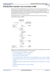
OZROX FIELD DATABAS
SITES
OUTCROPS
STRUCTURES
ROCKS
Figure 1. Simplified Structure of AGSO's Geological Database System.
PETROG is one of a number of field and laboratory databases that make up AGSO's Geological Database System (Figure 1). ROCKCHEM, for example, is a laboratory database of
rock chemistry (Ryburn, 1990) that shares field and sample infonnation with PETROG. So
© Australian Geological Survey Organisation 1994 -
Users' Guide to AGSO's Petrography Database
1
does OZCHRON, the database of Australian Geochronology (Ryburn et a/., 1993a). Other
databases such as OZMIN, AGSO's database of Australian Mineral Deposits, tap into the
point location information (SITES table) in the OZROX Field Database. Comprehensive
information on the rock samples and their locations also reside in OZROX, which is
described in detail in the user's guide to that database (Ryburn et ai., 1993b). However,
brief accounts of the parts of the Field Database that are critical to PETROG are also
included here. All databases currently run on the Oracle 6.0 relational database management
system (RDBMS) under UNIX 5.4 on AGSO's DG AViiON 6240 computer, and are
accessible from all PCs, terminals and workstations on the AGSO Ethernet network.
This guide describes the infrastructure of PETROG, including all screen forms, report
programs and definitions of all fields, views and tables. For information on the AVii ON
server, network, AGSO's Oracle environments and the use of SQL*Plus, SQL* Forms, etc.,
see the 'Users' Guide to AGSO's Oracle Database System' (Lenz et al. 1993).
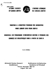
2 - STRUCTURE OF THE OZROX FIELD DATABASE
Figure 2. The structure of the OZROX Field Database showing relationships between
tables with 'crows' feet' at the 'many' end of many-to-one links. The authority table
labels emphasise function and are not necessarily actual table names (see below).
© Australian Geological Survey Organisation 1994 -
Users' Guide to AGSO's Petrography Database
2
•
•
•
•
•
•
•
•
•
•
•
•
•
•
•
•
•
•
•
•
•
•
•
•
•
•
•
•
•
•
•
•
•
•
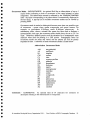
OZROX has five main data tables - SITES, OUTCROPS, ROCKS, LITHDATA and
STRUCTURES - of which SITES and ROCKS are of particular interest to PETROO.
These tables are accessed via the Sites and Rocks screen forms, which are briefly described
later in this guide (see sections 7 and 8). Most of the other tables in Figure 2 are lookup
tables used to validate the classifications and nomenclature used in the main tables.
The main data tables in OZROX are owned by the Oracle user 'N011A' (OZROX was
formerly known as the NOMA Field Database. However, the ownership of various tables by
'NOMA' is too finnly embedded in numerous AGSO applications to contemplate changing).
The ownership of all tables is indicated in the full table names by the prefix occurring before
the decimal point. The contents of the main OZROX data tables are as follows -
TABLE NAME
CONTENTS
NOMA.SITES
NOMA. OUTCROPS
NOMA.ROCKS
NOMA.LITHDATA
NOMA. STRUCTURES
NOMA.ROCKREFS
ground sites location data, accuracy & lineage
outcrop-related data, including drill holes
rock samples and lithological data
extendable attributes for the ROCKS table
mesoscopic structures at a site or outcrop
bibliographic reference versus rock samples
In addition, the following views of the above tables allow ordinary users (as opposed to
owners or custodians) to add, update and delete their own data - NGMA.USITES,
NOMA.UOUTCROPS, NGMA.UROCKS, NGMA.ULITHDATA NGMA.USTRUCTURES
and NGMA.UROCKREFS. There are also a number of authority tables and one view, not all
of which belong to NOMA. Those of possible interest to PETROO users include -
TABLE OR VIEW
CONTENTS
NOMA. ORIGINATORS
NOMA.AGSOCQDNTRIES
NOMA.AGSOSTATES
NOMA.QMAPS
NGMA.HMAPS
NOMA.LOCMETHODS
NOMA.ROCKTYPES
NOMA.LITHNAMES
NOMA.LITHDATATYPES
NGMA.AGSOMINERALS
NOMA.ROCKDATATYPES
contributors of data
Murray Hazell
Rod Ryburn
list of valid countries
list of valid Australian States
Rod Ryburn
Murray Hazell
Australian 1:250 000 map sheets
Australian 1: 100 000 map sheets
Murray Hazell
spatial location methods
Richard Blewett
basic classification of rock types
Lesley Wyborn
lithological names
Jan Knutson
extendable lithological attributes
P. Sruan-Smith
mineral names
Morrie Duggan
view of lithdatatypes/agsominerals union
STRATA.GEOPROVS
STRATA.STRATLEX
STRATA.GEOTIME
Australian geological provinces
Australian stratigraphic names
geological time scale
© Australian Geological Survey Organisation 1994 -
CUSTODIAN
D. Palfreyman
Cathy Brown
John Laurie
Users' Guide to AGSO's Petrography Database
3
As a general rule, only the designated custodians are pemritted to change the data in these
tables. Full deflnitions of all tables, indexes and views used by the OZROX Field Database
are given in the appendix to Ryburn et al. CI993b).
3 - STRUCTURE OF PETROG
As indicated in Figure 3, PETROG consists of three main data tables and three validation
tables. As its name implies, the central data table is THINSECTIONS, which holds one
record for each thin section in the database. In addition to the many-to-one link shown to
NGMA.ROCKS, THINSECTIONS is also tied to NGMA.SITES by the inclusion of a Site
ID. TSA TTRIBS is an extendable attributes table that allows a variable number of
controlled attributes and values to be attached to each thin section. This is for attributes,
such as alterations or texture, that apply to the section as a whole, rather than individual
components. Note that several values of the same attributes may be entered - e.g., two
different kinds of alteration. The third table, TSMINERALS is for the quantiflable
components of a thin section - in crystalline rocks this means rock-fomring minerals. In
sedimentary rocks, though, each record is for classes of detrital grains, matrix, cement, etc.
ZlROCKS }'IJE:lD DATAnAS
'W"""G !J) Al'AJBASE---i---------II'----m
~DU!l'llEA~LLS
&CI:.AS1iS
1I'l~
IN
SE·cnou~.s
EX'l'E!I'IlDA13lE
~,1ii A1.13,IJ1i ES
Figure 3. Structure of PETROG showing joins to OXROX tables and the Bibliographic
Reference Database. The validation tables are lightly stippled. The 'many' end of
many-to-one joins are indicated by 'crows feet'.
© Australian Geological Survey Organisation 1994 -
Users' Guide to AGSO's Petrography Database
4
The validation or lookup tables shown in Figure 3 limit possible entries into the data tables
to defined sets. The TSDATATYPES table validates entries into the TSATTRIBS table only attributes and values listed in TSDATATYPES can be entered into TSATTRIBS.
Entries into the TSMINERALS table are controlled by a view called TSMINCLASTS,
which is a union of the validation table NGMA.AGSOMINERALS with the TSCLASTYPES table for detrital clast nomenclature. This emulates a single table listing clast types
first, followed by mineral names. Not shown in figure 3 is the NGIVIA.ORIGINATORS
table, which validates originators entered in THINSECTIONS. ORIGINATORS lists the
names and numbers of all 'Originators' of rock samples. The Originator Number is an
essential component to the identification of all sites and samples (see section 4) and is
present with the Site and Sample ID in the THINSECTIONS table.
The tables used by PETROG and their contents are listed below. The Oracle owner of each
table is indicated by the part of each table name before the 'decimal point'.
TABLE OR VIEW
^
CONTENTS
PETROG.THINSECTIONS thin section data, including lD and rock name
^
PETROG.TSATTRIBS
extendable attributes of a thin section as a whole
^
PETROG.TSMINERALS
mineral or clast components of the thin section
NGMA.ORIGINATORS^list of valid originators for THINSECTIONS
PETROG.TSDATATYPES list of valid attributes and values for TSATTRIBS
PETROG.TSMINOCCMODES list of valid occurrence modes for TSIVEINERALS
PETROG.TSCLASTYPES^list of valid clast types for TS/vIINCLASTS
NGMA.AGSOMINERALS list of valid mineral names for TSMINCLASTS
PETROG.TSMINCLASTS union of AGSOMTNERALS + TSCLASTYPES
- a validation view for use with TSMINERALS
PETROG.ROCKIvIlNSITES view joining S1 ES, ROCKS, THINSECTIONS
and TSMINERALS - for use by Arc/Info
PETROG.MAXTSNO
^
table for tracking TSNO in THINSECTIONS
Full definitions of all tables, views, grants and indexes belonging to PETROG are listed in
the appendix to this guide. The custodian for TSDATATYPES, TSCLASTYPES and
TSMINOCCMODES is Jan Knutson.
© Australian Geological Survey Organisation 1994 - Users' Guide to AGSO's Petrography Database
^
5
4- SITE AND SAMPLE NUMBERING
Tables in PETROG and the OZROX Field Database maintain original site and sample
'numbers with the help of an Originator Number (Origno). In most cases the sample number
will be the same as the site number, perhaps with one or two appended letters to distinguish
several samples at the one site, but sample numbers can be unrelated to site numbers. If
all sites and samples were from AGS 0, and had unique registered numbers, then the site and
sample numbers would be sufficient on their own. However, AGSO databases also contain
data provided by universities, State geological surveys, companies and private individuals, all
of whom use their own numbering systems. The Originator Number is needed to preserve
uniqueness amongst diverse numbering systems. Originator numbers are recorded against
names in the NGMA.ORIGINATORS authority table.
The originator of a site or sample is the person or organisation primarily responsible for the
data. This could be the person who observed the site or collected the sample, a laboratory
worker, or an author of published results - someone who might reasonably be expected to
know about the sample and its collection point, and perhaps be able to supply further
information. Note that the name of the Originator is recorded only once in the database. All
other references to the Originator use the Originator Number, which is listed against the
name in the NGMA. ORIGINATORS table.
A site in the SITES table is fully identified by a unique combination of Originator Number
and Site ID (Siteid), the latter being any sequence of numbers and letters up to 16 characters
long. The uniqueness of an Originator Number and Site ID combination is enforced by a
unique index covering these fields. Similarly, a sample in the ROCKS table is fully identified
by a unique combination of Originator Number and Sample ID (Sampleid), which is
protected by a trigger in the ROCKS form - it is not possible to enter a combination already
in the ROCKS table. Although a sample number on its own is usually sufficient to fetch the
required sample, do not forget that sample numbers on their own are not necessarily
unique. The THINSECTIONS table in PETROG records the Originator Number, Site ID
and Sample ID. Site and sample data must be entered into OZROX before the thin section
data can be entered into PETROG.
© Australian Geological Survey Organisation 1994 - Users' Guide to AGSO's Petrography Database ^6
0
8
5- SECURITY AND ACCESS
Select-Only Database Access
The Oracle production environment allows all internal AGSO users select-only access to the
main data tables in both the OZROX and PETROG. The menu system provides 'read-only'
versions of the forms that allow users to select most of the data in the databases, but not to
insert, update or delete data. Users should also have select-only access to all validation
tables. When in SQL*Plus, all users may select data from any of these tables provided they
include the owner's name plus a full stop in the name of the table or view, e.g. SELECT SAMPLEID FROM NGMA.ROCKS WHERE ORIGNO = 56;
SELECT SITEID FROM PETROG.THINSECTIONS WHERE ORIGNO = 56;
Insert, Update and Delete Oracle Access
In both OZROX and PETROG all internal Oracle users in the production environment can
add, change or delete their own data. This is accomplished via special named views. Those
relevant to PETROG, and their corresponding base tables, are as follows BASE TABLE
INSERT/UPDATE VIEW
NGMA.SITES
NGMA..ROCKS
PETROG.THINSECTIONS
PETROG.TSATTRIBS
PETROG.TSMINERALS
NGMA.USITES
NGMA.UROCKS
PETROG.UTHINSECTIONS
PETROG.UTSATTRLBS
PETROG.U'FSMINERALS
From the menu, special 'Insert/Update' versions of each form cover the above views. The
restrictions applying to the above views are the same in each case. For example, the view
UTSATTRMS of the TSA ITRIBS table is defined as CREATE VIEW UTSATTRIBS AS
SELECT * FROM TSATTRIBS WHERE ENTEREDBY = USER;
The word USER in the above statement is an Oracle function that returns the current Oracle
username. Each of the above tables has the mandatory field ENTEREDBY for the
username of the person entering the data. This scheme guarantees that the users see only
0 Australian Geological Survey Organisation 1994 - Users' Guide to AGSO's Petrography Database
^
7
their own records in the insert/update versions of the forms, and only they or the data
custodians can alter or delete them.
Users wishing to use SQL*Plus to insert, update or delete records in the above main tables
(or SQL*Loader to load records from an ASCII file) must use the above views.
Custodians' Access Privileges
Ail custodians have been given appropriate access privileges to the data or authority tables
that they administer. They may select, insert, update and delete all data in these tables via
screen forms or from SQL*Plus. They cannot drop tables or alter the structure of tables.
Note that custodians use the 'read-only' forms to insert, update and delete rows in the main
data tables. This is because their access privileges apply to the base tables, not to views of
the tables. The 'insert-update' versions of the forms, which correspond to the insert/update
views in the database, only allow access to records in which the EN1EREDBY field has
their personal Oracle username.
Owners' Access Rights
The Oracle user known as PETROG has complete privileges on all the tables it owns in the
Petrography Database, as does the user NOMA in the OZROX Field Database. In other
words, these users are the owners of their respective databases. However, once a database
has been 'locked' in the production environment, all changes affecting the structure of tables
and views must first be submitted by the owner to the database administrator via the changecontrol directory (see Kucka,1994).
© Australian Geological Survey Organisation 1994 -
Users' Guide to AGSO's Petrography Database
8
•
•
•
•
•
•
•
•
•
•
•
•
•
•
•
•
•
•
•
•
•
•
•
•
•
•
•
••
•
•
•
•
•
•
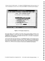
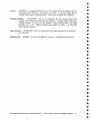
6- MENU SYSTEM
Access to OZROX and PETROG is via a tree-structured menu system. This provides access
to SQL*Plus, some reporting programs and nearly all screen forms associated with the
AGSO Geological Database System. Most ad-hoc queries, data inserts and updates are
done via screen forms, although you should also know that batch retrievals and updates are
often done via SQL*Plus (see Lenz et al., 1993). To run the menu type ngma <ENTER>
- after logging into the AViiON UNIX environment and specifying your terminal type. This
automatically puts you into the Oracle production environment and brings up the
SQL*Menu login screen. After entering your Oracle usemame and password, the first menu
screen is displayed. This currently looks like this -
VT220 Terminal to AVii ON
Elle Edit Transmit VT-FuneKeYs VT-ShittFuncKeYs SetuP.... Help
.
9GGO'S GEOLOGICAL DA TABASES !MIK KENO
Field and Laboratory Databases
1.
2.
SMOG Field Database
Stratigraptiic aut#01749 .Da t abase
.
:4 Rommel- :Database.,
112CHROW Da tabase
_ PETROC Database
.^0211111- Database :
7. :StreanuChept" Database
K. RockProps 'Database''
..9. SQLPIus:
Exit - -,bale *eon
.
.
-
Enter pour choice:
Ervoironnent
Production
<Rep>•
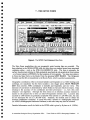
Figure 4. The Main Menu for AGSO's Geological Database System. This menu gives
access to nearly all areas of AGSO's Geological Field and Laboratory Database system.
Selecting item 10 in the menu, or pressing the EXIT function key, takes you back to the
UNIX prompt. Item 9 puts you into the SQL*Plus command-line environment without
O Australian Geological Survey Organisation 1994 - Users' Guide to AGSO's Petrography Database ^9
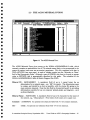
having to log into Oracle again. To engage the PETROG database menu just enter 5, or
move the highlight bar down to item 5 then press ENTER. The following screen appears -
vr220 Terminal to Mill ON
VT-ShiftFuncKeys
PETROC - 005O 2 S PETRODMMPR9 OfiTABASE
The
Petrography
or Thin Section Database
0288X -FOrvis
2_ Petrutraf.h Farm
-
Read ma
D- PetrugraPDY Fern — InsertiMPMate
4- PetriagraRD9 Data 1 8Peu farm .5- RiDlingraPhic References fore 6 - . MRSO Minerals Form .
. 7- TS Runfoolents fnrn
8_ aceorrencia -Nudes Form
.9- fetregralibY Relmort.1 2 regrau
le- Exit Sub enu
:Enter your choice:
0
0
^
^
0 iication:
Hlenu: PETROGRAPH
<Re >
Figure 5. The Petrography Database Menu.
0
This menu allows you to engage all the forms and the report program relating to the
Petrography Database, as well as the menus for the OZROX Field Database. To run the
OZROX Sites or Rocks Forms, for example, first select item I in the menu. Selecting item
10 returns you to the Main Menu All the screen forms and report relevant to the PETROG Database and accessible from the
above menu are now described, including the Sites, Rocks, References, and AGSO Mineral
Forms from the Field Database. Refer to 'The Users' Guide to the NGMA Field Database'
(Rybum et al., 1993b) for the full details of forms from the 07ROX Field Database.
0
0
•
0
0
•
@ Australian Geological Survey Organisation 1994 - Users' Guide to AGSO's Petrography Database 10
^
0
•
•
•
•
•
•
•
•
•
•
•
•
•
•
•
•
•
•
•
•
•
•
•
•
•
•
•
•
•
•
•
•
•
•
7 • THE SITES FORM
II
VT220Terminalto,lWiiON
aa
Figure 6. The OZROX Field Database's Sites Form.
The Sites Form standardises the way geographic point location data are recorded. The
form attaches to the NOMA. SITES table, but also draws on standard terms from associated
validation tables - such as the STRATA.OEOPROVS table. The form is primarily for
surface location data relating to field geological, geochemical and geophysical observations
- or of more interest to PETROO, for the locations of rock samples. You may move directly from the Sites Form to the Rocks Form by pressing NEXT BLOCK. The Originator
Number and Site ID are transferred to the Rocks Form, which is queried automatically.
Geographic coordinates, either as decimal latitudes and longitudes or as AMG eastings and
northings, are mandatory but the form includes a key trigger (press NEXT PRIMARY
KEY) that converts AMG coordinates to latitudes and longitudes, and vice versa. The
direction of conversion is determined by which fields are full and which are empty. Data
relating to the accuracy of the coordinates and their provenance - i.e., how they were
obtained - are important. Although the form insists on an absolute accuracy estimate in
metres on the ground this is often an order-of-magnitude estimate only. Location data
accurate to ±100 metres are generally acceptable when plotted at 1:250 000 scale. but may
be too inaccurate for use at 1:50 000 scale. Similarly, the method used to obtain the
location coordinates is essential. If a map was used. a pointer to a bibliographic reference
(in AOSO's Bibliographic Reference Database) to the exact map may also be included.
Detailed information on all the fields in the SITES table is given by Ryburn et al. (l993b).
© Australian Geological Survey Organisation 1994 -
Users' Guide to AGSO's Petrography Database
11
8 - THE ROCKS FORM
J
t:oloUl-
gl-ey
fine
massive
thin section
cleaved
r:leavage
Cleavage dipping
Uein
Uein dolet-ite
r;y
Gr-ain Size
F
Intel-nal Stl-atif MAS
Salllple Type
TS
Tectonic Featun~ Cll)
I
Figure 7. The Field Database's Rocks (and Structures) Form.
The Rocks (and Structures) Form is for data on lithologies, rock samples and mesoscopic
geological structures that occur at a site or outcrop. It is a three-block form covering the
ROCKS, LITHDATA and STRUCTURES tables. The ROCKS table has a many-to-one
relationship with the SITES. The LITHDATA table has a many-to-one relationship with
the ROCKS table and functions as an extendable attributes table for that table. The
STRUCTURES table also has a many-to-one relationship with the ROCKS table. A
system-generated 'ROCKNO' key ties all three blocks together.
If a sample exists a Sample Number must be supplied, otherwise the record is regarded as a
lithology observation without a sample having been taken_ The sample number can be the
site number, or can be different, but it must be unique to the originator. If the site number
is used and several samples were taken, then the site number is typically modified by
adding letters to represent each sample. This is the recommended system. as the
connection between samples and sites is made clear. However, the data comes from many
sources, and as far as possible the numbering system used by the originator should be
preserved.
The defmitions and purposes of the fields in this form are given by Ryburn et al. (1993b).
© Australian Geological Survey Organisation 1994 -
Users' Guide to AGSO's Petrography Database
12
•
•
•
•
•
•
•
•
•
•
•
•
•
•
•
•
•
•
•e'
•
•
•
•
•
•
•
•
•
•
•
•
•
•
9 - THE PETROGRAPHY FORM
VT-ShiftFuncKeys
file Edit Transmit
R Originator
0 Sample ID .
C Qualifier
IC 'pescription
S Strat. 'Unit
fETROG DATA ASE :.:PMUICRAPAY FARM:
.
READAMM
^
.^,.::
22. Knutson, J.^'_S.iteAD'92836410^Entered 11
92826410R^Rock' Ho 15^RocRJ ,eI metasediment
graphitic^'Litheloi Name schist
fine-grained, crenulated, banded graphitic schist _
Sefton Metamor hics
JKNUTSO
It
S
T Thin Sec.I8 92836410B^
.4E'ritered 23 - FEB - 93 *8 JKNUTSO
Graphite Schist
S Rock Maim?
Drillhole samile From Iron Ranoe area
ConnentS
Ualue
Ale5tription^chars) or R eference
Attribute
^ ^
CA
carbonate
minor
Alteration
A AL
HM
associated with graphite and pyrite, n
T ALT > Alteration
^hematitic
SE
sericitic
perUasive in feldspar
T:ALT Alteration
uero fine ^
R GS
Crain Size ^
toartz u to 0_3 nn across in coarser,
uon Occurrence
f Mineral or Clast
Comments ^
(64 chars)
[
SERC Sericite
QZ^
Quartz
GR^ Graphite
PL^Plagioclase
MS
Muscovite
pres
,
RP
CR
replacement
granular
replacing feldspar
interlocking grains in quartz-rich
crenulated and intergrown with mus
some alteration to sericite and ca
crenulated
1EXTREY-to co 'TS:A3lOtk].1101CW:44AmetiO-fUlcks-SiOck: Descri tion'
25
20
20
15
10
Count:
-<Replace>
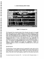
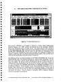
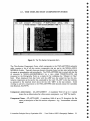
Figure 8. The Petrography Form.
The Petrography Form encompasses almost all the information that needs to be recorded
about a thin section of a rock, including pointers to any relevant references in AGSO's
Shared Bibliographic Reference Database. The form has four blocks corresponding to four
tables - the NGMA.ROCKS table from the OZROX database and the THINSECTIONS,
TSATTRIBS and TSMINERALS tables from PETROG. The master block is the ROCKS
block, as a rock sample can give rise to more than one thin section. In other words, the
THINSECTIONS block is a detail of the ROCKS block. The TSA riRIBS and
TSMINERALS blocks are, in turn, both detail blocks of the THINSECTIONS block. A
thin section may have any number of attributes and any number of component minerals or
clasts. The ROCKS and THINSECTIONS blocks are joined by a combination of
Originator Number (ORIGNO) and Sample ID (SAMPLED), whereas the
THINSECTIONS block is joined to TSATTRIBS and TSMINERALS by the Thin Section
Number (TSNO).
ROCKS BLOCK
The Rocks Block is for query purposes only and is automatically in query mode when the
form is first invoked. You normally use the Petrography Form by first executing a query in
the Rocks Block as to the sample or samples required. Do not execute an open query (no
select criteria) unless you have plenty of time. It is possible to query from any of the four
blocks, as the form is fully 'block-coordinated'. Before a new thin section record can be
0 Australian Geological Survey Organisation 1994 - Users' Guide to AGSO's Petrography Database 13
added to PETROa, information on the relevant site and rock sample must exist in the
OZROX database. To enter or update data in the ROCKS table use the fRocks &
Structures' Form from the OZROX database. However, with the help of a key trigger, the
Lithological Description in the ROCKS table can be updated from the Rock Name field in
the TIIlN SECTIONS block (see 'Rock Name' field description).
Originator - (ORIGNO) Mandatory integer of up to 5 digits that automatically displays
the corresponding originator's name. Only the number of an originator already
in the NGMA.ORIGINATORS table is enterable. A pop-up list of originators
and their numbers may be viewed by pressing the LIST key - from which an
originator may be selected with the ACCEPT or ENTER key. The originator is
usually the geologist, or sometimes the organisation, that collected the rock
sample at the site. It is also an indication of where to go for more information.
Site ID - (SITEID) Mandatory field of up to 16 characters for a user-supplied number or
ID for the site from which the thin section comes. A validation trigger ensures
that a record with the given Originator Number and Site ID already exists in
OZROX's NGMA.SlTES table, otherwise a thin section cannot be entered.
Entered By - (ENTEREDBY) Mandatory field for the Oracle Owner (username) of the
current ROCKS record. This need not be the same as the owner of the thin
section record in the next block. The date entered (ENTRYDATE) is also a
mandatory field in the ROCKS table, but is not shown in the Petrography fonn.
Sample ID - (SAMPLEID) A mandatory field of 16 characters for the ID of the rock
sample the thin section comes from. The Sample ID is unique to the
Originator, but it need bear no relationship to the Site ID. AGSO originators
should use an AGSO registered number with one appended letter, or two letters
if more than 26 samples were taken from a site.
Rockno· (ROCKNO) A system-generated mandatory positive integer of up to 6 digits
which is the primary key for the ROCKS table.
Rock Type - (ROCKTYPE) A positive integer of up to two digits that identifies the basic
rock type from a look-up list of 17 possibilities. This field is designed for a
first-pass coarse classification of rock types, as followsNumber
1
2
3
4
5
6
7
8
9
10
Rock Type
unknown
felsic intrusive
intermediate intrusive
mafic intrusive
felsic extrusive
intennediate exttusive
mafic extrusive
ultramafite
alkaline igneous
clastic sediment
© Australian Geological Survey Organisation 1994 - Users' Guide to AGSO's Petrography Database
14
•
•••
•
•
•
•
•••
•
•
•
•
•e.
e:
e:
.:
•
•
•
•
•
•
•
•
•
•
•
•
•
•
•
•
11^chemical sediment
12^metabasite
13^felsic gneiss
14^metasediment
15^metasomatite
16^ore
17^regolith
Lithology Qualifier - (QUALIFIER) A 20-character optional field for the qualifying
term, if any, before the Lithology Name field that follows. An abbreviation
may be entered in the associated short field that automatically retrieves the full
term. The full term is what is stored in the ROCKS table. The qualifying term
must be in the NGMA.LITHNAIVIES authority table and classified as Type 'Q'
for qualifier. An example of a Qualifier is 'pelitic' (abbreviation ?EL"), as in
'pelitic schist'. Valid lithology qualifiers may be selected from a pop-up list
obtained by pressing LIST.
Lithology Name - (LITHNAME) A 32-character optional field for a lithology name. An
abbreviation may be entered in the associated short field to fetch the full term,
but the full term is what is stored in the ROCKS table. Only names already in
the NGMA.LITHNAMES authority table, and classified as Type of T, 'M' or 'S'
(igneous, metamorphic, sedimentary), may be entered. Valid Ethology names
may be selected from a pop-up list obtained by pressing LIST.
Stratigraphic Unit - (STRATNO) The name of the stratigraphic unit pointed to by the
STRATNO number field in the ROCKS table. This name comes from the
Stratigraphic Lexicon (STRATA.STRATLEX). Informal names from the
INFORMAL field in ROCKS are not displayed in the Petrography Form.
THIN SECTION BLOCK
The Thin Section Block, which corresponds to the THINSECTIONS table, contains basic
information about the thin section as a whole, such as the ID of thin section and the
Ethological name of the rock. The THINSECTIONS table is linked to the NGMA.ROCKS
table via the Originator Number and Sample ID displayed in the Rocks Block. However,
the primary key for the THINSECTIONS table is the system-supplied Thin Section
Number (TSNO) - which should not be confused with the user-supplied Thin Section ID.
Thin Section ID - (THINSECTID) An optional, 16-character field for a user-supplied
number or other ID for the thin section. This should correspond to whatever ID
is written on the thin section. The Thin Section ID is commonly the same as
the Sample ID, but it could be completely unrelated. Where several thin
sections are cut from one rock sample, the Thin Section ID will change while
the Sample ID remains unchanged. Note that each thin section must occupy a
separate record in the THINSECTIONS table.
9^CD Australian Geological Survey Organisation 1994 - Users' Guide to AGSO's Petrography Database 15
Thin Section Number - (TSNO) A mandatory positive integer of up to 6 digits which is
the primary key for the THINSECTIONS table, and is what links the table to
the TSA TTRIBS and TSMINERALS tables. The number is automatically
inserted when a new THINSECTIONS record is committed. This field may be
entered by the user only in query mode.
Entered - (ENTRYDA TE) Mandatory date field for the date the current record was
entered into the THINSECTIONS table. The fonnat is the default Oracle
format of 'DD-MMM-YY' - e.g., '21-JUN-94'. This field is automatically
inserted by a trigger when a new record is committed. The cursor can be
moved into this field only when the fonn is in query mode.
By -
(ENTERED BY) Mandatory field of up to 8 capital letters for the Oracle
Owner (username) of the current record. This field is automatically inserted by
a trigger when the record is first committed. The cursor can be moved into this
field only when the fonn is in query mode.
Rock Name - (ROCKNAME) An optional, uncontrolled, 64-character field for a
petrological name based on microscopic examination of the thin section. The
name entered here can be copied directly into the Lithological Description field
(DESCRIPTION) of the ROCKS table by pressing the NEXT PRIMARY KEY
function key. Note, however, that this could result in a loss of information, as
the name originally entered in the ROCKS table is based on field observation,
and may include information not apparent in a single thin section (e.g., 'basalt
with sparse olivine nodules'). Use with caution.
Comments - (COMMENTS) An optional 64-character field for any additional comments
specifically about the thin section (e.g. 'Section excludes all weathered rind
material') that are not covered by fields in the SITES or ROCKS tables, or the
two controlled blocks that follow.
EXTENDABLE ATTRIBUTES BLOCK
The Extendable Attributes Block, which corresponds to the TSATTRIBS table, is designed
to accommodate varying amounts of information about the thin section as a whole - e.g.,
grainsize, texture and metamorphic grade. It can also accommodate pointers to references
in AGSO's Shared Bibliographic Reference Database. TSATIRIBS has the fonn of an
'invened' table, similar to the table underlying the Extendable Attributes Block in the Rocks
Form, in which attributes with values occupy rows in the table, rather than columns. This
has the advantages that any number of attributes with values may be entered, and that new
attributes, with their associated value domains, may be added to the database as the need
arises. The attributes and values that can be entered are controlled by the look-up table
TSDATATYPES.
Attribute - (DATATYPE) A mandatory field for an abbreviation of up to 4 capital letters
pointing to an attribute CDatatype') in the TSDATATYPES table. The
attribute's name is automatically displayed in the next field. Only attributes
© Australian Geological Survey Organisation 1994 - Users' Guide to AGSO's Petrography Database
16
••
•
•
•
•
•
•
•
•
•
•
•
•
•e.
•
•
•
•
•
•
•
•
•
•
•
••
•
•
•
•
•
•
•
•
•
•
•
•
•
•
•
•
•
•
•
•
•
•
•
•
•
•
•
•
•
•
•
•
•
•
•
•
•
•
•
•
already in the TSDATATYPES view may be entered, but the same attribute
can be used more than once (e.g. - a thin section may exhibit two types of
alteration). A pop-up list of available attributes can be viewed by pressing
LIST. The TSDATATYPES view currently has the following attributesAbbreviation
ALT
CTX
DTX
GS
ITX
MET
MTX
REF
SOR
STX
WEA
Attribute Name
Alteration
Carbonate Texture
Dolomitic Texture
Grain Size
Igneous Texture
Metamorphic Grade
Metamorphic Texture
Bibliographic Reference
Sorting
Sedimentary Texture
Weathering
Note that pointers to references are inserted by entering 'REF' as an attribute
and value, and the Reference ID in the Description field.
Value - (SUBTYPE) A mandatory field for an abbreviation of up to 4 capital letters
referring to a value of an attribute in the TSDATATYPES view. If the value
exists, its description is automatically displayed in the next field, otherwise an
error message appears at the bottom of the form. A pop-up list of available
values for the attribute already entered in the current record may be displayed
by pressing LIST. For example, the 'ALT' or Alteration attribute presently has
the following values Abbreviation
PR
AB
AL
AR
CA
CL
EP
GR
HM
KA
PO
PY
SE
SP
S1
SK
ZE
Value Name
propylitic
albitic
alunitic
argillic
carbonate
chloritic
epidotised
greisen
hematitic
kaolinitic
potassic
pyritic
sericitic
serpentinised
silicified
skarn
zeolitic
© Australian Geological Survey Organisation 1994 - Users' Guide to AGSO's Petrography Database
17
This system allows new attributes and values to be added to the
TSDATATYPES by the custodian, as and when required. (Note, however, that
the custodian is not free to delete or alter existing attributes and values without
first attending to any potential referential integrity problems. The
TSDATATYPES table currently links to the TSATTRIBS table, and there may
also be other dependent tables in the future).
40
Description (or Reference) - (DESCRIPTION) An optional field of 64 characters for
any additional descriptive information relating to the Data Type/Subtype
record. For example, one may wish to comment on the mode of occurrence of
a mineral in a sample. An important exception to this is the use of the field for
inserting a pointer to a reference. In this case, the lD of the reference in
AGSO's Bibliographic Reference Database must be entered. As indicated by
the message line at the bottom of the screen when the cursor is in this field, you
can jump directly to the References Form by pressing NEXT KEY.
0
0
MINERALS & CLASTS BLOCK
This block is specifically for data on the quantifiable components of a thin section. In thin
sections of igneous or metamorphic rocks the components are principally the mineral
species that go to make up the rock - sometimes the groundmass. In thin sections of
sedimentary rocks the components are mainly classes of detrital grain or clasts, as well as
the matrix or cement between the clasts.
Mineral or Clast - (MINERAL) A mandatory field for an abbreviation of up to 4 capital
letters pointing to a mineral or clast in the TSMINCLASTS view. The name
corresponding to the abbreviation is automatically displayed in the next field.
Only abbreviations already in the TSMINCLASTS view can be entered, but the
same mineral or clast can be used more than once (e.g. - a thin section may
have quartz clasts and a quartz matrix). A pop-up list of available mineral or
clasts can be viewed by pressing LIST. Note that clast types are displayed first
in this list, as there are much fewer of these than rock-forming minerals. The
terms 'matrix', 'groundmass', 'cement', and 'void' are included, as these are thin
section components that are commonly quantified as to their volume
percentage.
•
Volume Percent - (PERCENT) An optional numeric field for the volume percentage of
the thin section composed of the stated mineral, clast, matrix, etc. Values may
be entered of up to 100.0%, and with one digit after the decimal point. Since
numbers only can be entered into this field, negative numbers are used in lieu
of a less-than symbol. Thus, '-1.0' is taken to mean `<1.0' (less than one
percent), and is equivalent to the conventional 'accessory' or 'trace' annotation
that often appears on cards. This follows the convention used in the
ROCKCHEM database (Rybum, 1990).
© Australian Geological Survey Organisation 1994 - Users' Guide to AGSO's Petrography Database 18
•
•
•
•
•
•
•
•
•
-
Occurrence Mode (MINOCCMODE) An optional field for an abbreviation of up to 4
capital letters indicating a mode of occurrence of the stated mineral or other
component. The abbreviation entered is validated by the TSMINOCCMODES
table - the name corresponding to the abbreviation is automatically displayed in
the next field. A pop-up list of available occurrence modes can be viewed by
pressing LIST.
Occurrence mode is needed to distinguish between more than one possible type
of occurrence - quartz clasts, quartz overgrowths and quartz cement, for
•
example, or groundmass K-feldspar versus K-feldspar phenocrysts. In
sedimentary rocks, where a mineral like quartz has been used to indicate a
•
monomineralic clast type, the occurrence mode should always be set to 'CL' for
'clase. Otherwise, detrital kyanite could be mistaken for a metamorphic zone
•
indicator when used for plotting in a GIS system. Petrographic terms for
O^occurrence modes are many and varied, and the present list will be greatly
expanded in time. A selection of some occurrence modes is listed below •
o
•
Abbreviation Occurrence Mode
•
AM^amygdaloidal
O
•
•
•
•
•
•
•
•
•
•
AU^authigenic
BI^biogenic
CM^cement
CL^clast
CR^cryptocrystalline
GR^granular
GM^groundmass
IN^inclusion
MX^matrix
MG^microgranular
MC^microlite
00^oolitic
OG^overgrowth
PL^pellet
PH^phenocryst
PB^poiphyroblast
RP^replacement
XC^xenocryst
XL^xenolith
0
et^Comments - (COMMENTS) An optional field of 64 characters for comment or
description relating to the stated mineral or component.
•
•
•^
•
•
0 Australian Geological Survey Organisation 1994 - Users' Guide to AGSO's Petrography Database 19
0
10- THE PETROGRAPHY DATA TYPES FORM -
File Edit Transmit VT-Func Keys VT-ShiftFunc Keys aetup...
Bell)
PETROG DATABASE^PETROGRAPHY DATA TYPES^AUTHORrTY TABLEDescri 1 tion
ALT Alteration^
All
ALT
ALT^
ALT
ALT
ALT
ALT
ALT
ALT
ALT
AL
AL
ALT
ALT
ALT
ALT
CTX
0
Subt^e & Descri • tiun
AS
Al
AR
CA
CL
EP
CR
Hm
KA
PO
PR
Py
SE
SP
SI
SC
ZE
Carbonate Texture^ACH
albitic
alunitic
argillic
carbonate
chloritic
epidotised
greisen
heatitic
m
kaolinitic
potassic
propylitic
pyritic
sericitic
serpentinised
silicified
skarn
zeolitic
achritarchs
<Rellace>
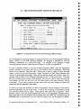
Figure 9. The Petrography Data Types Form.
The Petrography Data Types Form, which covers the TSDATATYPES table, gives access
to a list of attributes and values used to validate entries in the TSATTRIBS table. The twofold division of this list into data types and subtypes is similar to that used by the
NGMA.LITHDATATYPES table that lies behind the Rocks Form in the OZROX database.
The initial list is not regarded as complete. Users requiring additions to this authority table
should pass their requests to the custodian (Jan Knutson, Xtn 9479).
9
0
0
Type -^(DATATYPE) A mandatory field of up to 4 capital letters for an abbreviation
for a petrography data type, or attribute - e.g. 'ALT' for Alteration.
Type Description - (TYPEDESC) An optional field of up to 32 characters for a
description of the data type - e.g., 'Alteration'. As this is, in effect, an attribute
name, the first letters of all main words should be capitalised.
Subtype - (SUBTYPE) A mandatory field of up to 4 capital letters for an abbreviation for
a data subtype, or attribute value - e.g. 'AB' for albitic.
Subtype Description - (SUBDESC) An optional field of up to 32 characters for a
description of the data subtype - e.g., `Albitic'.
0
0
CD Australian Geological Survey Organisation 1994 - Users Guide to AGSO's Petrography Database 20
0
11- THE BIBLIOGRAPHIC REFERENCES FORM
•
•
•
•
•
•
VT220 Terminal to AVii ON
file EdIt Iransmi t VT-FuncEeys VT-ShiftFuncKeys
-
J6903/02
J0963/02:
J0903/02
J0903/02
J0903/02
40903/02
J0903/9 2_
.
Author
Year
Title
Source
^ 02ROX FIELD DATABASE RACKS BERM REFERENCES FARM ^
Rockno Orig^Site ID^Sa le ID^Entered
22-NOU.93
76283006
92,9 >> 76283006
9262
9264
9266
9295
9308
9275
22-N00-93
22-HO U-93
22-44100-92
22-NAU-93
22-NO U-93
22-NO U-93
76283023
76283057
76283074
76283272
77283980
76283227
76283623
76283657
76283674
76283272
77283986
76283227
JSHERATA
JSHERAT0
JSHERATO
JSHE RAID
JSHERATO
JSHERAT6
411FRATO
.
Sheraton J.W.
Ellis D.J.
Kuehner S.M_
OthéZDGEUON Reference :4JcirierGEOWS
1985^
Rare earth geochemistry of Archaean orthogneisses and evolution of Ui
e East Antarctic Sheild.
8HR Journal of Australian Geology & Geophysics
^
P ages P 267 18
Ref ID J0903/02
Dol & Part 9(3)^
-- The reference database must be ueried before a new reference can e added --
,
<Rellace>
Count: *7
Figure 10. The (Rock) References Form.
0
•
•
•
•
•
Thin sections in PETROG may be linked to references in AGSO's Shared Bibliographic
Reference Database via a 'REF' attribute and Reference ED in the Extendable Attributes
Block of the Petrography Form (see pages 16-18). The AGSO Reference ID is entered in
the Description field of the 'REF' record, and the above References Form can be invoked by
pressing NEXT PRIMARY KEY when the cursor is in that field in the Petrography Form.
Note, however, that the References Form shown in Figure 10 is primarily for linking rock
samples to references, and the top block exists solely for that purpose. The top block is not
used at all when specifically linking thin sections to references.
The References Form's top block corresponds to the NGMA.ROCKREFS table. It joins the
NGMA.ROCKS table to the Reference Database in a many-to-many relationship. For any
•
given rock sample there could be several references, and any one reference may refer to
many rock samples. The top block shows all the Reference Ds for a particular Rockno, or
•
all Rocknos for a particular Reference ID. The bottom two blocks, which display a reference
•
at a time, correspond to the GEOREF.AGSOAUTHS and GEOREF.AGSOREFS views of
the
Reference Database. These encompass a union with the GEODX bibliography (Lenz &
•
Modrak, 1990), which has over 22 000 references on Australian geology. As the cursor is
moved from record to record in the top block, the corresponding reference is displayed in
•
the bottom two blocks. For the purpose of accessing AGSO's Reference Database,
' 0^
however, the top block can be ignored.
© Australian Geological Survey Organisation 1994 - Users Guide to AGSO's Petrography Database 21
0
This form can also be used to inspect and insert the references pointed to by the
Bibliographic Reference field in the NGMA.SITES table. A more complete description of
AGSO's Bibliographic Reference Database will be published in the users' guide to that
database, but the information presented here is adequate for entering references required by
PETROG, or attaching sites and rock samples to references.
To query AGSO's Reference Database by Ref. ID, authors, year, etc., press NEXT BLOCK
to position the cursor in the Authors (or Reference) Block, then press ENTER QUERY to
obtain a pop-up query form. Enter your query information in this form then press
EXECUTE QUERY to retrieve one or more reference to the underlying form. Make your
query criteria as specific as possible to speed retrieval. Single author queries are slow if
there are many references by that author. Use NEXT RECORD to scroll through more than
one reference, and NEXT KEY to transfer the Reference ID of the currently displayed
reference to the top block - to which a Rockno must be added. In this way, pre-existing
references in the References Database may be attached to rock samples.
To prevent the entry of duplicate references the form insists that you query the Reference
Database before you can enter a new reference or update an existing one. Having done so,
though, you are free to enter or update more than one reference. The onus is on the user to
try to prevent the duplication of references in the shared database (a percentage of
duplicated records is inevitable). To obtain the Reference Insert/Update Form press
INSERT RECORD when the cursor is in the top block. Enter and commit the required
reference. The same procedure may be used to update existing references, but only those
references belonging to you (the entry form will only display references with your Oracle
user name attached to them). You should not update a reference to the extent that it
becomes another reference, as other people may have set pointers to the reference from
other databases. Use updates only to correct errors in existing references. All new
references go into the GEOREF.AUTHORS and GEOREF.REFERENCES tables.
TOP BLOCK
Not all the fields in the Top Block belong to the underlying NGMA.ROCKREFS table. As
soon as a 'Rockno' is entered, the Originator, Site ID and Sample ID fields are automatically
populated by a trigger from the NGMA.ROCKS table. To enter new records into
ROCKREFS just add them to the bottom of the displayed records with NEXT FIELD. As
already mentioned, in this block the INSERT RECORD key takes you directly to the screen
for entering new references.
Reference ID - (REFID) A 9-character field for the ID of a bibliographic reference in
AM's Reference Database. The ID of GEODX references in the database are
various e.g. '79/20055', R156"G0LD239 . The IDs of non GEODX
references are always a number starting with an asterisk e.g. '*2156 1 .
-
1
-
-
Rockno
-
(R.00KNO) As in the Rocks Form - the primary key of the NGIVIA.ROCKS
table. Only Rocknos already entered in that table may be entered here.
•
•
•
•
0
0 Australian Geological Survey Organisation 1994 - Users' Guide to AGSO's Petrography Database 22
^
•
•
•
•
•
Originator - (ORIGNO) As in the Petrography Form. Display field only.
•
Site ED - (Si 1E1D) As in the Petrography Form. Display field only.
a
•
•
•
Sample ID - (SAMPLED) As in the Petrography Form. Display field only.
Entered - (ENTRYDATE) As in the Petrography Form.
By -^(ENTEREDBY) As in the Petrography Form.
•
•
AUTHORS BLOCK
•
The Authors Block provides access to the GEOREF.AGSOAUTHS view (read only).
•
Authors - (AUTHNAME) A mandatory character field of up to 32 characters for the
•
•
•
surname of an author in lower case (except for the first letter) followed by a
space and the author's initials with full stops and no spaces between the initials.
Capital letters can also occur inside a surname (e.g., d'Albertis, McDonald).
Order Number - (ORDERNO) A positive integer of up to two digits indicating the order
of the author in the authors list of the reference. This field must be entered,
must start with one, and must increment by one.
•
•
Reference ID - (REFID) As in the Top Block. The pointer to the reference record.
•
REFERENCE BLOCK
•
The References Block corresponds to the GEOREF.AGSOREFS view (read only).
•
•
Year^(YEAR) A mandatory character field of up to 32 characters for the year of
publication of the reference.
•
Other ED - (OTHERID) An optional 32 character field for any alternative reference number
•
or ID. All references from GEODX have the value `GEODX Reference'
displayed in this field.
•
•
Owner - (ENTEREDBY) A mandatory 8-character field for the Oracle user name of the
person or database owner who entered the reference in the AGSO Reference
Database system.
•
Title -^(TITLE) A mandatory field of up to 255 characters for the title of the reference.
•
Use a full stop at the end of the title. In symposium-style references the title of
the symposium or collected works should also be entered, following the word
'In' and the names and initials of the editors - plus (Ed) or (Eds).
•
Use lower case except for the first letter of the first word and all proper names.
•
•
•
•
© Australian Geological Survey Organisation 1994 - Users' Guide to AGSO's Petrography Database 23
Source - (SOURCE) A mandatory field of up to 255 characters for the journal name or
publication of the reference. Use mostly lower case - as in the title field. Do not
include volume, part, or page numbers. A pick list is available from GEODX.
Volume and Part - (VOLPART) Up to 32 characters for the volume and/or part
number of the publication containing the reference. A single number indicates a
volume number. If a part or issue number is also included place it in round
brackets, e.g., '1 (3)'. Special volumes may require text entry - e.g. `The Sam
Carey Special Volume'.
411
41
Page Numbers. (PAGENOS) Up to 32 characters for the page numbers of the reference e.g. '234-257'.
Reference ID - (REFLD) As in the Top Block of the form - the primary reference key.
0
© Australian Geological Survey Organisation 1994 - Users' Guide to AGSO's Petrography Database 24
12- THE AGSO MINERALS FORM
''''''^' • '^•^, ''''' , . •
JTerminlalthIi
File Edit Transmit VT-FuncKeys VT-ShiftFuncKeys Setup... Help
AGS0 MINERALS AUTHORITY TABLE
ID^Name
^
ACM^Acanthite
ACT^Actinolite
ADO^Adularia
AEG^Aegirine
ACT^Aegirine—augite
REM ^Aenigmatite
AIR
^Aikinite
AK ^Akermanite
ALB^Alabandite
AB ^Albite
ALM^Allanite
ALP^Allophane
ALM^Almandine
ALT^Altaite
ART^Aluminokataphorite
AL ^Alunite
AMB^Amblygonite
Amesite
AMS
Common Ore
I.
Count: 18
<Replace>
Figure 11. The AGSO Minerals Form.
The AGSO Minerals Form gives access to the NGMA.AGSOMINERALS table, which
currently contains an authoritative list of 776 mineral names likely to be encountered in the
course of routine (and some not-so-routine) geoscience. This list, combined with that in
TSCLASTYPES (see next page), is used to validate entries into the 'Minerals or Clasts'
field of the Petrography Form. Although a part of OZROX, this form is of equal or greater
value to PETROG, and is appropriately described in this guide. The custodian of the
NGIVIA.AGSOIVIINERALS table is Morrie Duggan (Xtm 9284).
Mineral ID - (MINABBREV) A mandatory field of up to 4 capital letters for an
abbreviation for a mineral name - e.g. 'QZ' for quartz. The abbreviation must
be unique, and should be as short as possible, with the shorter IDs going to the
more common minerals. Note that this field is of potential benefit in providing
abbreviations suitable for use on computer plotted graphs and diagrams - such
as phase diagrams.
Mineral Name - (MINNAME) A mandatory field of up to 32 characters for the name of
the mineral, e.g., `Glaucophane. First letters of all names are in upper case.
Common - (COMMON) An optional one-character field with 'C' for common minerals.
Ore -^(ORE) An optional one-character field with '0' for ore minerals.
© Australian Geological Survey Organisation 1994 - Users' Guide to AGSO's Petrography Database 25
13- THE THIN-SECTION COMPONENTS FORM
0
VI220 Terminal to AVii ON
VT-FuncKeys VT-ShiftFuncKeys Setup.- • :help-PETROP DATABAg 7:T 11 1 111- SECTIO °MP NENT FORK
.
ID
CC
CM
CH
FP
FUL
CRC
GS
CRC
IRE
UC
LC
LT
mUC
MX
MRF
F
00
Con anent Name
arbonate clasts
carbonate matrix
chert clasts
clap matrix
fecal pellets
felsic volcanic clasts
gabbroic clasts
glass shards
granitic clasts
igneous rock fragments
intermediate volcanic clasts
limestone clasts
lithic clasts
mafic volcanic clasts
matrix
metamorphic rock fragments
0
oir
microfossils
oolites
S
aelIace>
Figure 12. The Thin-Section Components Form.
The Thin-Section Components Form, which correponds to the TSCLASTYPES authority
table, contains a list of all thin section components that are not in the NGMA.AGS0MINERALS table. Typically these are classes of detrital clasts, but they also include types
of matrix or groundmass, and microfossils. The TSCLASTYPES list is united with the list
of minerals in NGMA.AGSOMINERALS via a view called TSMINCLASTS, and
presented to the Petrography Form as a single list for validating the 'Mineral or Gime
field. When displayed from that form with the LIST key, the united list has the nonmineral components at the top the list, annotated by the word 'CLAST' in the last column,
as opposed to the minerals lower down the list with 'MIN' in the last column. Users
wishing to add new components to the TSCLASTYPES table should contact the custodian
(Jan Knutson, Xtn 9479).
Component Abbreviation - (CLASTABBREV) A mandatory field of up to 4 capital
letters for an abbreviation for a thin - section component - e.g. 'MX' for matrix.
Component Name - (CLASTNAME) A mandatory field of up to 32 characters for the
name or description of the thin-section component - e.g., 'intermediate volcanic
clasts'.
© Australian Geological Survey Organisation 1994 - Users Guide to AGSO's Petrography Database 26
•
14- OCCURRENCE MODES FORM
VT220 Terminal to AVii 0 N
Ede Edit Ransmit VT FundEeYs VT ShittFuncKelis Setup-- BelP
-
-
PETROG DATABASE.- MINERAI:.00CURRENCE
PMDES :FORM
.^
.
-
ID^Occurrence Na me
amygdaloidal
authigenic
biogenic
cement
clast
cryptocrystalline
granular
graphic intergrouth
groundmass
inclusion
matrix
microgranular
microlite
mimetic
oolitic
overgrouth
pellet
ehenocristic
Figure 13. The Mineral Occurrence Modes Form.
This form corresponds to the TSMINOCCMODES authority table, housing occurrence
modes of thin section minerals (more correctly, thin section components, as occurrence
modes of clasts and matrix are included). Mineral species often occur in more than one
form - K-feldspar may occur both as phenocrysts and in the groundmass, or quartz can
occur as clasts and as cement. In such cases, different modes of mineral occurrence should
be recorded and quantified in the Petrography Form as different components of the same
thin section. Similarly, glaucophane can be a metamorphic indicator or a detrital mineral,
and it is important to distinguish between the two modes of occurrence in a manner that
promotes reliable retrieval of information. To illustrate, we do not want occurrences of
detrital glaucophane being used to map blueschist facies domains in a GIS system. For this
reason the 'clase mode of occurrence should always be added in the Petrography Form to
mineral components that represent as a class of detrital grains. The list contained in the
TSMINOCCMODES table will undoubtedly need to extended at regular intervals. The
venerable art of petrography is peppered with esoteric terms applying to modes of mineral
occurrence. Contact the custodian (Jan Knutson, Xtn 9479) if you wish to add more terms.
Occurrence Abbreviation - (OCCABBREV) A mandatory field of up to 4 capital letters
for an abbreviation for an occurrence mode - e.g. 'PH' for phenocrystic.
Occurrence Name - (OCCNAME) A mandatory field of up to 32 characters for the name
or description of the mode of occurrence - e.g., `groundmass'.
O Australian Geological Survey Organisation 1994 - Users Guide to AGSO's Petrography Database 27
•
if
15- THE PETROGRAPHY REPORT PROGRAM
Edit Iransmit
PETROG
VT-FuncKeys VT-ShiftFuncKeys
setup...
fielp
AGSO'S PETROGRAPHY DATABASE - UM REPORT SELECTION MENU
Number of samples selected'hy previoUs query =^-
- Name of output file.
PETROG.LIS
Select IV ealGNO-....
•
Lower
• M36416
Upper
92836410
Select by QMA PID....
23
if
"
Select bY
7
Other - e.g. entrydate '4-JON-94°
Sorting clause - ORDER BY S ITESARIGND. SITES SITEID
C- G
- Exit
CHOOSE BY NUMBER OR LETTE
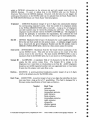
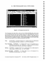
Figure 14. The Selection Menu from the SOR Petrography Report Program.
This comprehensive reporting program is engaged from item 9 in the Petrography Database
Menu. Written in the SQR reporting language, the program is designed to print all
PETROG information on a site-by-site basis. An example of the program's output
resulting from the selection criteria shown in Figure 14 is given in Appendix B.
To post a selection criterion in the above Report Selection Menu, enter the appropriate
number indicated in the menu and type in the required value as prompted. Enclosing
quotes are not required. Note that item 7 allows you to enter a variety of SQL selection
criteria - exactly as you do following the 'where' keyword in a SQL select statement (but
without the terminating semicolon). When all the selection criteria are in place, enter G to
proceed with the report to the UNIX file indicated at item 1 of the above menu. Note that
this file is written to your current UNIX directory (the one you were in when you typed the
word ngma), and that any prior file with the same name in the same directory will be
overwritten. If you want to produce several output files you must change the output file
name each time you generate a new report.
As soon as the report has finished, the menu is redisplayed with the number of thin section
retrieved indicated at the top of the menu. If this is not according to expectations, revise
your selection criteria and try again. Large reports take some time to generate. When
finished, enter X to exit the report program and return to the Petrography Database Menu.
The output files from this program can be printed with the UNIX `lp' command (e.g., lp
PETROG.LIS), or transferred to your PC with File Express (in LAN Workplace for DOS).
© Australian Geological Survey Organisation 1994 - Users' Guide to AGSO's Petrography Database 28
if
16- ACKNOWLEDGMENTS
The development of AGSO's Petrography Database has been a team effort, and has
benefited from the input of a number of AGSO staff members. In particular we wish to
mention Lynton Jaques for the initial concept of the geological field and laboratory
database system, and Phil O'Brien, John Sheraton, Peter Southgate, Peter Stuart-Smith,
David Wallace and Lesley Wyborn for various contributions during the planning
prototyping of PETROG.
This Record has benefited greatly from peer reviews by Gladys Warren and John Sheraton.
17
-
REFERENCES
Ewers, G.R. & Ryburn, R.J. 1993 - User's guide to the OZMIN mineral deposits database.
Australian Geological Survey Organisation, Record, 1993/94, 69pp.
Kucka, M., 1994 - AGSO's Oracle Developers' Guide. Australian Geological Survey
Organisation, Record, 1994/4.
Lenz, S.L., Ryburn, R.J. & Kucka, M., 1993 - Users' Guide to AGSO's Oracle Database
System. Australian Geological Survey Organisation, Record, 1993/81.
Lenz, S. & Modrak, K. 1990 - The Stratigraphic Index Database, GEODX - User Manual.
Australian Geological Survey Organisation, Record, 1990/16.
Rybum, R.J., 1990 - Users' Guide to the PetChem Database. Bureau of Mineral Resources,
Australia, Record, 1990/19, 53pp.
•
•
•
•
Ryburn, R.J., in prep. - Users' guide to the Stratigraphic Authority Database. Australian
Geological Survey Organisation, Record.
Ryburn, R.J., Blewett, R.S., Stuart-Smith, P.G. and Williams, P.R., 1993b - Users' guide to
the NGMA Field Database. Australian Geological Survey Organisadon, Record,
1993/49.
•
Ryburn, R.J., Page, R.W. & Richards, J.R. 1993a - Users' guide to the OZCHRON
Database of Australian Geochronology. Australian Geological Survey Organisation,
Record, 1993/11.
•
© Australian Geological Survey Organisation 1994 - Users' Guide to AGSO's Petrography Database 29
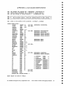
APPENDIX A. DATABASE DEFINITIONS
REM THE PRIMARY AND FOREIGN KEY ('REFERENCES') DEFINITIONS IN
REM CREATE-TABLE STATEMENTS ARE A FEATURE OF ORACLE VERSION 7
REM AND ARE IGNORED BY ORACLE VERSION 6 - DOCUMENTATION ONLY
REM ***********************************************************************
REM *** THE FOLLOWING TABLES, VIEWS AND INDEXES BELONG TO NGMA (OZROX) ***
Rgm ***********************************************************************
REM SITES IS FOR GROUND POINT LOCATIONS + ACCURACY & LINEAGE
CREATE TABLE SITES (
ORIGNO
NUMBER (5)
SITEID
CHAR^(16)
FIELDID
CHAR^(16),
OBSDATE
DATE,
OBSTIME
NUMBER (4,2),
COUNTRYID
CHAR^(3)
STATE
CHAR^(3)
GEOPROVNO
NUMBER (5)
SUBPROVNO
NUMBER (5)
DOMAINNO
NUMBER (5)
GEOGAREA
CHAR^(64),
LOCDESC
CHAR^(64),
HMAPNO
NUMBER (4)
QMAPID
CHAR^(6)
FASTING
NUMBER (8,2),
NORTHING
NUMBER (9,2),
ACCURACY
NUMBER (4)
HEIGHT
NUMBER (5,0),
HEIGHTACC
NUMBER (3,0),
NUMBER (8,6),
DLAT
CHAR^(1),
NS
DLONG
NUMBER (9,6),
EW
CHAR^(1),
METHOD
NUMBER (3)
BIBREF
CHAR^(9)
AIRPHOTO
CHAR^(36),
OC
CHAR.^(1),
RO
CHAR^(1),
CHAR^(1),
ST
CHAR.^(1),
PE
CHAR^(1),
RC
Oz
CHAR^(1),
OM
CHAR^(1),
SC
NOT NULL REFERENCES ORIGINATORS,
NOT NULL,
NOT NULL
REFERENCES
REFERENCES
REFERENCES
REFERENCES
REFERENCES
AGSOCOUNTRIES,
AGSOSTATES,
STRATA.GEOPROVS,
STRATA.GEOPROVS,
STRATA.GEOPROVS,
REFERENCES HMAPS,
REFERENCES OAPS,
NOT NULL,
NOT NULL
CHAR^(1),
RT
CHAR^(1) ,
RP
CHAR^Cl),
SP
CHAR^(1),
ENTEREDBY
CHAR^(8)
NOT NULL,
ENTRYDATE
DATE
NOT NULL,
LASTUPDATE
DATE,
PRIMARY KEY (ORIGNO,SITEID) );
REFERENCES LOCMETHODS,
REFERENCES GEOREF.AGSOREFS,
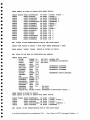
/* OUTCROPS^TABLE^*/
/* ROCKS^TABLE^*/
/* STRUCTURE^TABLE^*/
/* PETROGRAPHY DATABASE */
/* ROCKCHEM^DATABASE */
/* OZCHRON^DATABASE */
/* °EMIR^DATABASE */
/* STREAMCHEM^DATABASE */
/* REGOLITE^DATABASE */
/* ROCKPROPS^DATABASE */
/* SPECPROPS^DATABASE */
GRANT SELECT ON SITES TO PUBLIC;
40
41
40
40
40
410
41
0 Australian Geological Survey Organisation 1994 - Users' Guide to AGSO's Petrography Database 30
40
41
GRANT SELECT ON SITES TO PETROG WITH GRANT OPTION;
CREATE UNIQUE INDEX SITESUNIQUE^ON SITES ( ORIGNO, SITEID );
INDEX SITES/DS^ON SITES ( SITEID );
CREATE
INDEX SITESUSERS^ON SITES ( ENTEREDBY );
CREATE
INDEX SITESPRaVS^ON SITES ( GEOPROVNO );
CREATE
INDEX S/TESSUBPROVS ON SITES ( SUBPROVNO );
CREATE
INDEX SITESHMAPS^ON SITES ( HMAPNO );
CREATE
INDEX SITESQMAPS^ON SITES ( QMAPID );
CREATE
INDEX SITESDLATS^ON SITES ( DLAT );
CREATE
INDEX SITESDLONGS^ON SITES ( DLONG );
CREATE
INDEX SITESSTRUC^ON SITES ( ST );
CREATE
INDEX SITESSC^ON SITES ( SC );
CREATE
INDEX SITESRP^ON SITES ( RP );
CREATE
INDEX SITEOZCHRON^ON SITES ( OZ );
CREATE
CREATE
INDEX SITESOZM/N^ON SITES ( ON );
INDEX SITESRTMAP^ON SITES ( RT );
CREATE
REM UNITES IS THE INSERT/UPDATE VIEW OF THE SITES TABLE
CREATE VIEW UNITES AS SELECT * FROM SITES WHERE ENTEREDBY = USER;
GRANT SELECT, INSERT, UPDATE, DELETE ON UNITES TO PUBLIC;
REM ROCKS IS FOR DATA ON =NEOLOGIES AND SAMPLES
CREATE TABLE ROCKS
NUMBER (6)^NOT NULL PRIMARY KEY,
ROOT=
NUMBER (5,0) NOT NULL REFERENCES ORIGINATORS,
ORIGNO
CHAR (16) NOT NULL,
SITEID
CHAR^(16),
SAMPLEID
NUMBER (2,0)^REFERENCES ROCKTYPES,
ROCKTYPE
CHAR (20)^REFERENCES LITHNAMES,
QUALIFIER
CHAR (32)^REFERENCES LITENAMES,
LITHNAME
CHAR^(50),
GROUPING
^
REFERENCES STRATA. STRATLEX,
NUMBER (5,0)
STRATNO
CHAR^(64),
INFORMAL
AGE
CHAR^(54),
STRATHEIGHT NUMBER (8,3),
NUMBER (8),
HOLEDEPTU
NUMBER (8),
HOLEDEPTH2
DESCRIPTION CHAR^(64),
CHAR^(64),
OTHERINFO
CHAR (8)^NOT NULL,
ENTEREDBY
DAME^NOT NULL,
ENTRYDATE
FOREIGN KEY (ORIGNO,SITEID) REFERENCES SITES(ORIGNO,SITEID) );
GRANT SELECT ON ROCKS TO PUBLIC;
GRANT SELECT ON ROCKS TO PETROG WITH GRANT OPTION;
CREATE UNIQUE INDEX ROCKROCKNOS ON ROCKS ( ROCKNO );
CREATE^INDEX ROCKORIGSITES ON ROCKS ( ORIGNO, SITEID );
CREATE^INDEX ROCKSITES^ON ROCKS ( SITEID );
CREATE^INDEX ROCKORIGSAMPS ON ROCKS ( ORIGNO, SAMPLEID );
CREATE^INDEX ROCKUSERS^ON ROCKS ( ENTEREDBY
);
REM UROCKS IS THE INSERT/UPDATE VIEW OF THE ROCKS TABLE
0 Australian Geological Survey Organisation 1994 - Users Guide to AGSO's Petrography Database 31
CREATE VIEW UROCKS AS SELECT * FROM ROCKS WHERE ENTEREDBY = USER;
GRANT SELECT, INSERT, UPDATE, DELETE ON CROCKS TO PUBLIC;
REM LITHDATA IS THE EXTENDABLE ATTRIBUTES TABLE FOR ROCKS
CREATE TABLE LITHDATA (
ROCKNO^NUMBER
DATATYPE^CHAR
SUBTYPE^CHAR
DESCRIPTION CHAR
ENTEREDBY^CHAR
ENTRYDATE^DATE
PRIMARY KEY (ROCKNO,
(5,0) NOT NULL REFERENCES ROCKS,
NOT NULL REFERENCES LITHDATATYPES(DATATYPE),
(^
^
REFERENCES LITHDATATYPES(SUBTYPE),
(4)
(64),
(8)^NOT NULL,
NOT NULL,
DATATYPE, SUBTYPE) );
GRANT SELECT ON LITHDATA TO PUBLIC;
CREATE INDEX LDLITHNO ON LITHDATA ( ROCKNO );
CREATE INDEX LDUSERS ON LITHDATA ( USER );
REM ULITHDATA IS THE INSERT/UPDATE VIEW OF THE LITHDATA TABLE
CREATE VIEW ULITHDATA AS SELECT * FROM LITHDATA WHERE ENTEREDBY = USER;
^
GRANT SELECT, INSERT, UPDATE, DELETE ON ULITHDATA TO PUBLIC;
REM ORIGINATORS IS THE AUTHORITY TABLE FOR ORIGINATORS
CREATE TABLE ORIGINATORS (
ORIGNO^NUMBER (5,0) NOT NULL PRIMARY KEY,
ORIGINATOR CHAR (22) NOT NULL,
OWNER^CHAR^(8) );
GRANT SELECT ON ORIGINATORS TO PUBLIC;
CREATE UNIQUE INDEX ORIGNOS ON ORIGINATORS ( ORIGNO );
REM AGSO AUTHORITY TABLE OF MINERAL NAMES 6 THEIR ABBREVIATIONS
CREATE TABLE AGSOMINERALS (
^
MINABBREV
CHAR (4)^NOT NULL PRIMARY KEY,
^
CHAR (32) NOT NULL,
MINNAME
^
COMMON
CHAR (1),
^
ORE
CHAR^(1) );
CREATE UNIQUE INDEX AGSOMINABEEEVS ON AGSOMINERALS ( M/NABBREV );
CREATE UNIQUE INDEX AGSOMINNAMES ON AGSOMINERALS ( MINNAME );
CREATE^INDEX AGSOM/NCOMMONS ON AGSOMINERALS ( COMMON );
CREATE^INDEX AGSOMINORE^ON AGSOMINERALS ( ORE );
GRANT SELECT ON AGSOMINERALS TO PUBLIC;
GRANT SELECT ON AGSOMINERALS TO PETROG WITH GRANT OPTION;
© Australian Geological Survey Organisation 1994 - Users' Guide to AGSO's Petrography Database 32
0
REM ************************************************************************
REM ***^THE FOLLOWING TABLES, VIEWS AND INDEXES BELONG TO PETROG ^***
REM ************************************************************************
REM TRINSECTIONS IS THE MASTER DATA TABLE FOR PETROG
CREATE TABLE THINSECTIONS (
NUMBER
ORIGNO
CHAR
SITEID
CHAR
SAMPLEID
THINSECTID
CHAR
TSNO
NUMBER
ROCKNAME
CHAR
COMMENTS
CHAR
ENTEREDBY
CHAR
DATE
ENTRYDATE
(5)
(16)
(16)
(16),
(6)
(32),
(64),
(16)
•
NOT NULL
NOT NULL
NOT NULL
REFERENCES NGMA.ORIGINATORS,
REFERENCES NGMA.SITES(SITEID),
REFERENCES NGMA.ROCKS(SAMPLEID),
NOT NULL
PRIMARY KEY,
NOT NULL,
NOT NULL
)
;
GRANT SELECT ON THINSECTIONS TO PUBLIC;
CREATE UNIQUE INDEX
CREATE^INDEX
CREATE^INDEX
CREATE^INDEX
TSNOS ^ON
TH/NSECTIDS ON
TSORIGSITES ON
TSSITES^ON
THINSECTIONS(THNO);
THINSECT/ONS(THINSECTID);
THINSECTIONS(ORIGNO, SITEID);
THINSECTIONS(SITEID);
CREATE VIEW UTHINSECTIONS AS SELECT * FROM THINSECTIONS WHERE ENTEREBY = USER;
GRANT SELECT, INSERT, UPDATE, DELETE ON UTHINSECT/ONS TO PUBLIC;
REM MAXTSNO IS A ONE-ROW TABLE FOR KEEPING TRACK OF THE CURRENT HIGHEST TSNO
CREATE TABLE MAXTSNO (
HAMM^NUMBER (6) );
GRANT SELECT, UPDATE ON MAXTSNO TO PUBLIC;
REM TSATTRIBS IS THE EXTENDABLE ATTRIBUTES TABLE FOR THINSECTIONS
CREATE TABLE TSATTR/BS (
TSNO^NUMBER (6) NOT NULL REFERENCES THINSECTIONS,
DATATYPE^CHAR (4) NOT NULL REFERENCES TSDATATYPES(DATATYPE),
SUBTYPE^CHAR (4)^REFERENCES TSDATATYPES(SUBTYPE),
DESCRIPTION CHAR (64),
ENTEREDBY^CHAR (16),
ENTRYDATE^DATE );
GRANT SELECT ON TSATTRIES TO PUBLIC;
CREATE INDEX PATTRIBSNOS ON TSATTRIBS(TSNO);
CREATE VIEW UTSATTRIBS AS SELECT * FROM TSATTRIBS WHERE ENTEREBY = USER;
GRANT SELECT, INSERT, UPDATE, DELETE ON UTSATTRIBS TO PUBLIC;
© Australian Geological Survey Organisation 1994 - Users' Guide to AGSO's Petrography Database 33
REM TSDATATYPE IS THE AUTHORITY TABLE FOR TSATTRIBS EXTENDABLE ATTRIBUTES TABLE
CREATE TABLE TSDATATYPES (
DATATYPE^CHAR (4) NOT NULL,
TYPEDESC^CHAR^(32),
SUBTYPE^CHAR (4) NOT NULL,
SUBDESC^CHAR^(32) );
a
0
GRANT SELECT ON TSDATATYPES TO PUBLIC;
CREATE UNIQUE INDEX TSDATATYPES1 ON TSDATATYPES(DATATYPE,SUBTYPE);
CREATE UNIQUE INDEX TSDATATYPES2 ON TSDATMYPES(DAMATYPE);
REM TSMINERALS IS THE TABLE FOR A THIN SECTION'S COMPONENT MINERALS OR CLASTS
CREATE TABLE TSMINERALS (
TSNO^NUMBER (6) NOT NULL REFERENCES THINSECTIONS(TSNO),
MINERAL^CHAR (4) NOT NULL REFERENCES TSMINCLASTS(MINABBREV),
PERCENT^NUMBER (3,1),
OCCMODE^CHAR (4)^REFERENCES TSMINOCCMODES,
COMMENTS^CHAR (64),
ENTEREDBY^CHAR (16),
ENTRYDATE^DATE );
GRANT SELECT ON TSMINERALS TO PUBLIC;
CREATE INDEX PETMINNOS ON TSMINERALS(TSNO);
0
CREATE VIEW UTSMINERALS AS SELECT * FROM TSMINERALS WHERE ENTEREDBY = USER;
GRANT SELECT, INSERT, UPDATE, DELETE ON UTSMINERALS TO PUBLIC;
REM TSCLASTYPES IS THE VALIDATION TABLE FOR CLAST TYPES MUD MATRIX)
0
CREATE TABLE TSCLASTYPES (
CLASTABBREV^CHAR (4) NOT NULL,
CLASTNAME^CHAR (32) NOT NULL );
0
GRANT SELECT ON TSCLASTYPES TO PUBLIC;
REM TSMINCLASTS IS A VIEW OF A UNION BETWEEN NGMA.AGSOMINERALS AND TSCLASTYPES
REM THIS IS THE VALIDATION VIEW FOR ENTRIES IN THE TSMINERALS TABLE
CREATE VIEW TSMINCLASTS AS
SELECT MINABEREV, MINNAME, IMIN' MINOR CLAST FROM NOMA.AGSOMINERALS
UNION
SELECT CLASTABBREV, CLASTNAME, 'CLAST' FROM PETROG.TSCLASTYPES;
GRANT SELECT ON TSMINCLASTS TO PUBLIC;
0 Australian Geological Survey Organisation 1994 - Users' Guide to AGSO's Petrography Database 34
•
40
•
REM TSMINOCCMODES IS THE VALIDATION TABLE FOR MINERAL OCCURRENCE MODES
•
•
CREATE TABLE TSMINOCCMODES (
OCCABBREV^CHAR (4) NOT NULL,
OCCNAME^CHAR (32) NOT NULL
•
GRANT SELECT ON TSM/NOCMODES TO PUBLIC;
•
•
•
•
•
);
REM ROCKMINSITES IS A VIEW COMBINING SITE, ROCK, THIN-SECTION & MINERAL DATA
REM MAY BE USED FOR ARCINFO PLOTTING OF ROCK TYPES AND THIN-SECTION MINERALS
REM YEILDS ONE RECORD PER MINERAL, OR ONE PER THIN SECTION IF NO MINERALS NOTED
CREATE VIEW ROCKMINSITES AS SELECT
SITES.ORIGNO ORIGNO,
SITES. SITEID SITEID,
SITES.COUNTRYID,
SITES. STATE,
4P^SITES.GEOPROVUO,
SITES.SUBPROVNO,
•
•
•
•
40
•
•
•
•
•
•
•
•
•
•
•
SITES.DOMAINNO,
SITES.HMAPNO,
S/TES.QMAPID,
SITES.EASTING,
SITES.NORTHING,
SITES .ACCURACY,
SITES.DLAT,
SITES.DLONG,
ROCKS. SAMPLEID SAMPLEID,
ROCKS.ROCKTYPE,
ROCKS.QUALIFIER,
ROCKS.LITHNAME,
ROCKS. GROUPING,
ROCKS.STRATNO,
ROCKS.AGE,
THINSECTIONS.THINSECTID,
THINSECTIONS.ROCKNAME,
TSMINERALS.MINERAL,
TSMINERALS.PERCENT,
FROM NGMA.SITES, NGMA.ROCKS, PETROG.THINSECTIONS, PETROG.TSMINERALS
WHERE SITES.ORIGNO^= ROCKS.ORIGNO
AND SITES.SITEID^= ROCKS.SITEID
AND ROCKS.ORIGNO^= THINSECTIONS.ORIGNO
AND ROCKS.SAMPLEID^= THINSECTIONS.SAMPLEID
AND THINSECTIONS.ISNO = TSMINERALS.TSNO (+);
GRANT SELECT ON ROCKMINSITES TO PUBLIC;
© Australian Geological Survey Organisation 1994 - Users' Guide to AGSO's Petrography Database 35
•
APPENDIX B - EXAMPLE REPORT
The following hard-copy output was generated by the Petrography Database report
program PETROG.SQR - accessed at item 9 in the Petrography Database Menu. All thin
section data from Site ID 92836410 were selected via the PETROG Report Selection
Menu. The report output does not yet include references - just Reference IDs.
AGSO Petrography Database - 01-Ja1-1994 09:19 AM Page 1
************************************************
PETROGRAPHY DATABASE - Thin Section Descriptions
01-Jul-1994 09:19 AM
************************************************
Selection criteria are as follows Origno^= 23
Lower siteid = 92836410
Upper siteid = 92836410
250K Map
100K Map
Other where =
Sort clause = ORDER BY SITES.ORIGNO, SITES.SITEID
Australian Geological Survey Organisation 1994 - Users' Guide to AGSO's Petrography Database 36
AGSO Petrography Database - 01-Jul-1994 09:19 AM Page 2
ORIGNO: 23 SITEID: 92836410 ^DATE: 18-MAY-92 STATE: QLD
LOC DESC:
Northern Queen, NQD-2, Iron Range
^
SPROV:^DOMAIN:
PROV: 22
^
AMGEAST: 749950^AMGNORTH: 8594950
100K MAP: 7572
^
LOC METHOD: 0
ABS ACC: 100 AIRPHOTO:
ELEVATION:
^
SAMPLEID: 92836410A
ROCK NO: 14^LITH NAME: schist
^
NAME:
L_QUAL:
DESC: graphitic schist
STRAT UNIT: Sefton Metamorphics
TS NO:^15
ROCK NAME: Graphite schist
COMMENTS: Sefton Metamorphics, Iron Range
^DATA TYPE^SUBTYPE
Metamorphic Tex crenulated
Grain Size very fine
Metamorphic Tex schistose
Metamorphic Gra chlorite
MINERAL NAME
Quartz
Muscovite
Graphite
Carbonate
Opaque Mineral
DESCRIPTION
VOL%^COMMENTS
30 fine grained, sutured boundaries
30 finely laminated
20 finely laminated
10
2
SAMPLEID: 92836410B^ROCK NO: 15^LITH NAME: schist
NAME:^
L_QUAL: graphitic
DESC: fine-grained, crenulated, banded graphitic schist
STRAT UNIT: Sefton Metamorphics
TS NO:^16
ROCK NAME: Graphite Schist
COMMENTS: Drillhole sample from Iron Range area
DATA TYPE
Alteration
Alteration
Grain Size
SUBTYPE
sericitic
carbonate
very fine
Metamorphic Tex
Alteration
crenulated
hematitic
MINERAL NAME
Sericite
Quartz
Graphite
VOL%
COMMENTS
25
replacing feldspar
20
interlocking grains in quartz-rich lamellae
20
crenulated and intergrown with muscovite
and sericite
15
some alteration to sericite and carbonate
10
crenulated
3
replacing feldspar
Plagioclase
Muscovite
Carbonate
DESCRIPTION
pervasive in feldspar
minor
quartz up to 0.3 mm across in
coarser lamellae
defined by mica and graphite
associated with graphite and
pyrite, minor
0 Australian Geological Survey Organisation 1994 - Users' Guide to AGSO's Petrography Database 37
^
Carbonate^2^infilling stringer veins
Pyrite^1^minor
(page break)
AGSO Petrography Database - 01-Jul-1994 09:19 AM Page3
SAMPLEID: 92836410C^ROCK NO: 16^LITH NAME: schist
L_QUAL:
NAME:^
DESC: graphitic schist, minor iron staining
STRAT UNIT: Sefton Metamorphics
TS NO:^17
ROCK NAME: Graphite Schist
COMMENTS: Sefton Range Metamorphics
^DATA TYPE^SUBTYPE
Alteration^hematitic
Alteration^sericitic
Grain Size^fine
Metamorphic Tex crenulated
DESCRIPTION
associated with graphite
0
MINERAL NAME^VOL%^COMMENTS
Hematite^associated with graphite and pyrite
Quartz^30
Sericite^20 crenulated and interleaved with graphite
Muscovite^20 crenulated and interleaved with graphite
Graphite^15
Carbonate^10 secondary
Pyrite^1^closely associated with graphite
SAMPLEID: 92836410D^ROCK NO: 17^LITH NAME: schist
NAME:^
L_QUAL:
DESC: chlorite-rich rock with abundant iron staining
STRAT UNIT: Sefton Metamorphics
TS NO:^19
ROCK NAME: Chlorite Schist
COMMENTS: Sefton Metamorphics
DATA TYPE^SUBTYPE^DESCRIPTION
Metamorphic Tex foliated
Metamorphic Tex boudinaged ^carbonate
Grain Size^medium^fine-grained quartz,
carbonate up to 1-2 mm
Alteration^hematitic^minor iron staining
Metamorphic Gra chlorite
MINERAL NAME^VOL%^COMMENTS
Quartz^30 fine-grained, grading into strongly
deformed and sutured
Chlorite^30 foliated, wrapping around carbonate
Carbonate^25 boudinaged,
Pyrite^5^foliated
0
0
0
0
0
0 Australian Geological Survey Organisation 1994 - Users' Guide to AGSO's Petrography Database 38
0
0
•