1
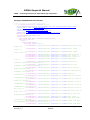
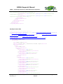
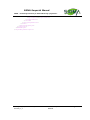
SIGMA Geoportal Manual SIGMA – Stimulating Innovation for Global Monitoring of Agriculture 1.4. Create SLD file An SLD file is an XML file which describes the appearance of your data when it is published in the geoportal as a viewing service, allowing users to view your data on the map. The SLD file defines the colour scheme used during the presentation. VITO will publish your data in geoServer as a WMS layer. Therefore is it important to provide the data: in a format supported by GDAL, e.g. geoTIFF. Certainly the data should be georeferenced. Regarding projection, either EPSG:4326 (LatLon) or EPSG:900913 (Google) Add an SLD file for optimal presentation of your dataset To edit such an SLD file, you can use the following tools: A simple text editor: use this if you start from an example as given below. AtlasStyler: http://en.geopublishing.org/AtlasStyler Arcgis Udig: http://udig.refractions.net/ Geoserver More information on SLDs can be found in the SLD-cookbook : http://docs.geoserver.org/stable/en/user/styling/index.html. Examples of SLD files: Simple SLD file without a color map <?xml version="1.0" encoding="ISO-88591"?> <StyledLayerDescriptor version="1.0.0" xsi:schemaLocation="http://www.opengis.net/sld StyledLayerDescriptor.xsd" xmlns="http://www.opengis.net/sld" xmlns:ogc="http://www.opengis.net/ogc" xmlns:xlink="http://www.w3.org/1999/xlink" xmlns:xsi="http://www.w3.org/2001/XMLSchema-instance"> <NamedLayer> <Name>colormap_testsld</Name> <UserStyle> <Title>SLD Cook Book: Discrete colors</Title> <FeatureTypeStyle> <Rule> <RasterSymbolizer> <ColorMap> <ColorMapEntry color="#008000" quantity="0" opacity="0"/> <ColorMapEntry color="#008000" quantity="255"/> </ColorMap> </RasterSymbolizer> </Rule> </FeatureTypeStyle> </UserStyle> </NamedLayer> </StyledLayerDescriptor> SIGMA_D2-x_Geoportal manual for Data Providers_1_2 SIGMA Geoportal Manual Page 14 of 17