1
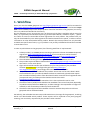
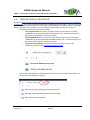
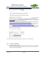
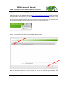
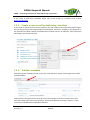
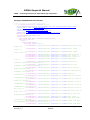
SIGMA GEOPORTAL MANUAL Quick Start for SIGMA Data Provider Reference: SIGMA_D2-x_Geoportal manual for Data Providers_1_2 Author(s): Goor Erwin Version: 1.2 Date: 14/10/2014 SIGMA Geoportal Manual SIGMA – Stimulating Innovation for Global Monitoring of Agriculture DOCUMENT CONTROL Signatures Author(s) : Erwin Goor (VITO) Reviewer(s) : Jens Verrydt (VITO), Bart Ooms (VITO) Approver(s) : Sven Gilliams (VITO) Issuing authority : Change record Release 1.0 Date 01/10/2014 Pages 1.1 1.2 08/10/2014 14/10/2014 Description First issue: delivered to beta users of WP3-4-5 Update of §1.1: ownCloud Update of §1.1: separate folders for public and projectrestrricted data Add §1.4: description of SLD SIGMA_D2-x_Geoportal manual for Data Providers_1_2 SIGMA Geoportal Manual Editor(s)/Reviewer(s) Erwin Goor (VITO) Erwin Goor (VITO) Erwin Goor (VITO) 1.3 Page 3 of 17 SIGMA Geoportal Manual SIGMA – Stimulating Innovation for Global Monitoring of Agriculture TABLE OF CONTENT EXECUTIVE SUMMARY ............................................................................................................ 6 1. Workflow .......................................................................................................................................................................7 1.1. Upload data to ownCloud ..........................................................................................................................................8 1.2. Create metadata ..........................................................................................................................................................9 1.2.1. Create from SIGMA template ................................................................................................................... 10 1.2.2. Create a new record by duplicating metadata ...................................................................................... 12 1.2.3. Validate metadata ...................................................................................................................................... 12 1.2.4. Submit metadata for publishing............................................................................................................... 13 1.3. Geo-wiki validation .................................................................................................................................................. 13 SIGMA_D2-x_Geoportal manual for Data Providers_1_2 SIGMA Geoportal Manual Page 4 of 17 SIGMA Geoportal Manual SIGMA – Stimulating Innovation for Global Monitoring of Agriculture ACRONYMS & GLOSSARY SIGMA_D2-x_Geoportal manual for Data Providers_1_2 SIGMA Geoportal Manual Page 5 of 17 SIGMA Geoportal Manual SIGMA – Stimulating Innovation for Global Monitoring of Agriculture EXECUTIVE SUMMARY This documents describes briefly how a SIGMA data provider can make products/services available on the SIGMA geoportal. SIGMA_D2-x_Geoportal manual for Data Providers_1_2 SIGMA Geoportal Manual Page 6 of 17 SIGMA Geoportal Manual SIGMA – Stimulating Innovation for Global Monitoring of Agriculture 1. Workflow Users can use the SIGMA geoportal on http://sigma.geoportal.vgt.vito.be (will be renamed to http://www.geoglam-sigma.info/geoportal in the near future) to discover, view and access output data from the SIGMA project. Each output product should be available in the geoportal, since only then it is published towards the community. On the Geoportal, every ‘anonymous user’ can discover which data is available and can view t he data (i.e. a quicklook). Furthermore reports (e.g. Product User Manual, Validation report, ..) which are useful for users are accessible without registration for each product. The product itself, can only be downloaded by users who registered and authenticated on the portal, in order to collect information on who downloaded which product. Remark that some products can only be made available to a specific set of users, e.g. if a product is not yet fully validated and should be restricted to some beta-users. In order to publish data on the geoportal, the following workflow is implemented: 1. A data provider (i.e. a SIGMA partners wishing to publish his data on the SIGMA Geoportal) registers on http://sigma.geoportal.vgt.vito.be. Then he sends an e-mail to the VITO administrators [email protected], [email protected] and [email protected] to become a service provider, or use [email protected]. 2. The VITO administrator grant the rights to the user to be a SIGMA data provider. 3. The provider copies the data to owncloud at http://sigma.geoportal.vgt.vito.be/owncloud/. See section 1.1 for more details. 4. If geo-wiki should be used for the validation (only for some products), the providers contacts the IIASA team to configure the geo-wiki (http://www.geowiki.org/branches/sigma/) accordingly. See section 1.3 for more details. 5. The providers write the metadata for the product. See section 1.2 for more details. With the metadata the user provides the URL to the data on ownCloud, uploads some reports and a thumbnail of the product. If the data should not be accessible for all registered users (exceptional case!), the data provider should mention this to VITO ([email protected]). 6. Finally, the provider submits the metadata. This is also explained in section 1.2.4. 7. The administrator (VITO) checks whether the metadata is correct and complete. Optionally, he publishes the product as a WMS layer, to allow viewing in the mapViewer. If a legend is needed, he will contact the provider to provide an SLD file. 8. The administrator approves the metadata. From this moment the product is visible on geoportal and can be downloaded. Periodically, the VITO administrator can provide statistics on the usage of the geoportal, including which user downloaded which product. These reports will be reported in the yearly progress meeting, but can also by requested by the providers when needed. SIGMA_D2-x_Geoportal manual for Data Providers_1_2 SIGMA Geoportal Manual Page 7 of 17 SIGMA Geoportal Manual SIGMA – Stimulating Innovation for Global Monitoring of Agriculture 1.1. Upload data to ownCloud Navigate to http://sigma.geoportal.vgt.vito.be/owncloud/index.php/apps/files/?dir=SIGMA data on geoportal. Use your userID/password from the SIGMA geoportal to log on. You can can upload your files or create subdirectories in the folders corresponding to the WP/task where it belongs. Remark that this is only possible if you are a Sigma Data Provider (ref step 2 in section 1). - First decide which users can access your data: o If any registered user can access your data, then store your data in the folder ‘SIGMA data on geoportal/Public for all registered users’. As data provider you’ll get reports from VITO who accessed your data. o If only SIGMA partners can access your data, then store your data in the folder ‘SIGMA data on geoportal/Private forSIGMA partners only’. As data provider you’ll get reports from VITO who accessed your data. o If only some selected users can access the data (e.g. since it’s still under validation), please contact [email protected] . - In the folder selected above, please upload your data in the correct WP.task number. You can make a new subfolder if needed: - You can upload a file in by using the following icon: SIGMA_D2-x_Geoportal manual for Data Providers_1_2 SIGMA Geoportal Manual Page 8 of 17 SIGMA Geoportal Manual SIGMA – Stimulating Innovation for Global Monitoring of Agriculture - - Alternatively, or if you want to upload complete folders, you can simply drag-and-drop the folder/file from e.g. your Windows explorer. So there’s no need to zip the content of a directory into a single zip-file. Remark that this drag&drop of ‘folders’ is only supported in Google Chrome! For single files, there’s no issue. As an alternative approach to upload complete folders to ownCloud, you can install a free Webdav client (e.g. Cyberduck) and use Webdav to transfer files to ‘http://sigma.geoportal.vgt.vito.be/owncloud/remote.php/webdav/’ . On linux, you can simple mount the Webdav SIGMA URL. More information on the use of Webdav, can be found on http://doc.owncloud.org/server/7.0/user_manual/files/files.html. For the next step, i.e. to create the metadata, you’ll need the URL to the product file/folder on onwcloud. Herefore, you can click with the right-mouse button on the file/folder and choose action ‘copy link address’: You don’t have to worry about access rights this is taken care of by the geoportal. 1.2. Create metadata There are two ways to create metadata: - Start from the SIGMA template. Use this the first time you add a product to the Geoportal - Copy & paste an existing metadata record and adapt this. Use this if you upload products which are similar to existing products. SIGMA_D2-x_Geoportal manual for Data Providers_1_2 SIGMA Geoportal Manual Page 9 of 17 SIGMA Geoportal Manual SIGMA – Stimulating Innovation for Global Monitoring of Agriculture 1.2.1. Create from SIGMA template A data provider can use the SIGMA Geoportal http://sigma.geoportal.vgt.vito.be to edit metadata, and hence publish his products on the Geoportal. This needs to be done for each product/service which you like to publish on the geoportal. On the geoportal, authenticate with your username. If you are a data provider, you can select the option ‘New metadata’ from the ‘actions’ menu item in the upper right corner. In the next dialogue, select the ‘template for SIGMA products’ and click on the ‘create’ button. As group, you should keep the default value ‘SIGMA-DataProviders’. Now the metadata editor can be used. Most of the values are prefilled if you start from the template: you can change these prefilled values if needed, but these should be ok. Some values are SIGMA_D2-x_Geoportal manual for Data Providers_1_2 SIGMA Geoportal Manual Page 10 of 17 SIGMA Geoportal Manual SIGMA – Stimulating Innovation for Global Monitoring of Agriculture empty and optional. Only provide values, if you are familiar with these & know which information should be provided. Fields which are marked with an asterix (*) are mandatory. Most of the fields should we self explanary. However in the template some suggestions are given & on the right pane, a help will give further explanations. Some specific points of attention: Point of contact: select here a value from the ‘suggestions’ list; as a consequence the logo of your organization will appear on the geoportal for this record. Please further fill in all details on your organization. Graphic Overview: this is a thumbnail which will appear on the portal for your product. Please use a png/jpg/gif (no tiff) for proper display on each browser. You can enter a URL (as filename) if you have published the thumbnail on an HTTP-server or you can upload a file from your computer using the ‘add thumbnail’ link. Descriptive keywords ‘SIGMA regions’, ‘SIGMA years’ and ‘SIGMA datatypes’: select a value from the list. If you need another value in these list, please contact VITO on [email protected]. Descriptive keywords ‘GEMET’: please change these values only if you’re familiar with it. Spatial resolution, Geographic bounding box, temporal extent: these should be correct! Transfer options – Online resource: here you reference data files which users can download from the Geoportal. o Filetype: Datafile: this is the actual data only authenticated users can see the data. Report: this can be a validation report, User manual, … which users can download. Any anonymous user can download this. Validation on geo-wiki: only use this if validation of your product is done using geo-wiki. o Protocol: URL from ownCloud or your server: select this value if you uploaded your datafile/report on ownCloud or your own HTTP server. In the next field URL you can specify this URL. File for download, uploaded on this server: here you can upload a file from your computer to the geoportal. o Name of resource: this text will appear on the geoportal, allowing users to download the resource. o Description & Function are optional only change when you need. If you want to upload multiple data files or reports: click on the the plus icon (+) next to ‘online resource’. SIGMA_D2-x_Geoportal manual for Data Providers_1_2 SIGMA Geoportal Manual Page 11 of 17 SIGMA Geoportal Manual SIGMA – Stimulating Innovation for Global Monitoring of Agriculture If you want to add more metadata which you cannot assign to a specific field, contact [email protected]. 1.2.2. Create a new record by duplicating metadata If you need to upload several similar products, you don’t need to start from the template again. You can simply copy an existing metadata record instead. Therefore, navigate on the geoportal in the ‘product list’ TAB to a specific metadata record other actions duplicate. Then proceed as described in the previous section. 1.2.3. Validate metadata After editing your metadata record, click on the ‘save and check’ button in the upper menu of the metadata editor. Please check in the right pane for errors & correct accordingly. If you don’t find the issue, then VITO will support you: select ‘save and close’ and proceed with the next step in section 1.2.4 to submit your metadata to the VITO administrators. SIGMA_D2-x_Geoportal manual for Data Providers_1_2 SIGMA Geoportal Manual Page 12 of 17 SIGMA Geoportal Manual SIGMA – Stimulating Innovation for Global Monitoring of Agriculture 1.2.4. Submit metadata for publishing When you are still authenticated as data provider, you’ll see your metadata record in the catalogue. At this moment, no other users see your new records. The final step is to submit this record: click on ‘actions’ next to the title of your metadata record and select ‘Set to submitted status’. As a result, the VITO administrators will be notified & take action to check, validate & publish your record. As a good practice, please send also an e -mail to the VITO administrators on [email protected]. If the data should not be accessible for all registered users (exceptional case!), the data provider should mention this to VITO ([email protected]). VITO will check the metadata and check whether all access rights on the products and reports are correct (by default products can only be download by authenticated users & reports can be downloaded by all users). When applicable, VITO can also publish your data a a WMS layer for viewing. Please check section 1.4 for more information. 1.3. Geo-wiki validation << To be provided when SIGMA geo-wiki is released >> SIGMA_D2-x_Geoportal manual for Data Providers_1_2 SIGMA Geoportal Manual Page 13 of 17 SIGMA Geoportal Manual SIGMA – Stimulating Innovation for Global Monitoring of Agriculture 1.4. Create SLD file An SLD file is an XML file which describes the appearance of your data when it is published in the geoportal as a viewing service, allowing users to view your data on the map. The SLD file defines the colour scheme used during the presentation. VITO will publish your data in geoServer as a WMS layer. Therefore is it important to provide the data: in a format supported by GDAL, e.g. geoTIFF. Certainly the data should be georeferenced. Regarding projection, either EPSG:4326 (LatLon) or EPSG:900913 (Google) Add an SLD file for optimal presentation of your dataset To edit such an SLD file, you can use the following tools: A simple text editor: use this if you start from an example as given below. AtlasStyler: http://en.geopublishing.org/AtlasStyler Arcgis Udig: http://udig.refractions.net/ Geoserver More information on SLDs can be found in the SLD-cookbook : http://docs.geoserver.org/stable/en/user/styling/index.html. Examples of SLD files: Simple SLD file without a color map <?xml version="1.0" encoding="ISO-88591"?> <StyledLayerDescriptor version="1.0.0" xsi:schemaLocation="http://www.opengis.net/sld StyledLayerDescriptor.xsd" xmlns="http://www.opengis.net/sld" xmlns:ogc="http://www.opengis.net/ogc" xmlns:xlink="http://www.w3.org/1999/xlink" xmlns:xsi="http://www.w3.org/2001/XMLSchema-instance"> <NamedLayer> <Name>colormap_testsld</Name> <UserStyle> <Title>SLD Cook Book: Discrete colors</Title> <FeatureTypeStyle> <Rule> <RasterSymbolizer> <ColorMap> <ColorMapEntry color="#008000" quantity="0" opacity="0"/> <ColorMapEntry color="#008000" quantity="255"/> </ColorMap> </RasterSymbolizer> </Rule> </FeatureTypeStyle> </UserStyle> </NamedLayer> </StyledLayerDescriptor> SIGMA_D2-x_Geoportal manual for Data Providers_1_2 SIGMA Geoportal Manual Page 14 of 17 SIGMA Geoportal Manual SIGMA – Stimulating Innovation for Global Monitoring of Agriculture SLD file for a RASTER data with colormap <?xml version="1.0" encoding="ISO-88591"?> <StyledLayerDescriptor version="1.0.0" xsi:schemaLocation="http://www.opengis.net/sld StyledLayerDescriptor.xsd" xmlns="http://www.opengis.net/sld" xmlns:ogc="http://www.opengis.net/ogc" xmlns:xlink="http://www.w3.org/1999/xlink" xmlns:xsi="http://www.w3.org/2001/XMLSchema-instance"> <NamedLayer> <Name>colormap_testsld</Name> <UserStyle> <Title>SLD Cook Book: Discrete colors</Title> <FeatureTypeStyle> <Rule> <RasterSymbolizer> <ColorMap type="values"> <ColorMapEntry color="#000000" quantity="0" label="Unclassified" opa city="0"/> <ColorMapEntry color="#bf003f" quantity="1" label="Arable field maize" /> <ColorMapEntry color="#ffaf4f" quantity="2" label="Arable field other crops" /> <ColorMapEntry color="#005f1f" quantity="3" label="Corsican pine" /> <ColorMapEntry color="#6f5f2f" quantity="4" label="Scots pine" /> <ColorMapEntry color="#009f3f" quantity="5" label="Birch forest" /> <ColorMapEntry color="#6fcf3f" quantity="6" label="Pedunculate oak" /> <ColorMapEntry color="#bfdf0f" quantity="7" label="Species-poor permanent agricultural grassland" /> <ColorMapEntry color="#bfbf1f" quantity="8" label="Species-rich permanent agricultural grassland" /> <ColorMapEntry color="#bfbf7f" quantity="9" label="Juncus effususdominated grassland" /> <ColorMapEntry color="#3fbf5f" quantity="10" label="Dry semi-natural permanent grassland" /> <ColorMapEntry color="#8f8f5f" quantity="11" label="Temporary grassland" /> <ColorMapEntry color="#ff7fcf" quantity="12" label="Calluna-stand of predominantly adult age" /> <ColorMapEntry color="#bf7fcf" quantity="13" label="Calluna-stand of mixed age classes" /> <ColorMapEntry color="#ef2f7f" quantity="14" label="Calluna-stand of predominantly old age" /> <ColorMapEntry color="#cf4fbf" quantity="15" label="Calluna-stand of predominantly young age" /> <ColorMapEntry color="#ff2fff" quantity="16" label="Molinia-stand on dry soil" /> <ColorMapEntry color="#df5f9f" quantity="17" label="Molinia-stand on moist soil" /> <ColorMapEntry color="#af2fef" quantity="18" label="Erica tetralixdominated heathland" /> <ColorMapEntry color="#ffffcf" quantity="19" label="Bare sand" /> <ColorMapEntry color="#efdfaf" quantity="20" label="Sand dune fixed by grasses and mosses" /> <ColorMapEntry color="#ffff00" quantity="21" label="Fixed sand dune with predominantly Campylopus introflexus" /> <ColorMapEntry color="#efffbf" quantity="22" label="Fixed sand dune SIGMA_D2-x_Geoportal manual for Data Providers_1_2 SIGMA Geoportal Manual Page 15 of 17 SIGMA Geoportal Manual SIGMA – Stimulating Innovation for Global Monitoring of Agriculture with predominantly Polytrichum piliferum" /> <ColorMapEntry color="#4f2fff" quantity="23" label="Unvegetated oligotrophic water" /> <ColorMapEntry color="#0f5fcf" quantity="24" label="Shallow, vegetated oligotrophic water body" /> </ColorMap> </RasterSymbolizer> </Rule> </FeatureTypeStyle> </UserStyle> </NamedLayer> </StyledLayerDescriptor> SLD file for vector data <?xml version="1.0" encoding="UTF-8"?> <StyledLayerDescriptor version="1.0.0" xmlns="http://www.opengis.net/sld" xmlns:og c="http://www.opengis.net/ogc" xmlns:xlink="http://www.w3.org/1999/xlink" xmlns:xsi="http://www.w3.org/2001/XML Schema-instance" xsi:schemaLocation="http://www.opengis.net/sld http://schemas.opengis.net/sld/1.0.0/StyledLayerDescriptor.xsd"> <NamedLayer> <Name>Blue lake</Name> <UserStyle> <Title>Blue lake</Title> <Abstract>A blue fill, solid black outline style</Abstract> <FeatureTypeStyle> <Rule> <Name>name</Name> <PolygonSymbolizer> <Fill> <CssParameter name="fill"> <ogc:Literal>#4040C0</ogc:Literal> </CssParameter> <CssParameter name="fill-opacity"> <ogc:Literal>1.0</ogc:Literal> </CssParameter> </Fill> <Stroke> <CssParameter name="stroke"> <ogc:Literal>#000000</ogc:Literal> </CssParameter> <CssParameter name="stroke-linecap"> <ogc:Literal>butt</ogc:Literal> </CssParameter> <CssParameter name="stroke-linejoin"> <ogc:Literal>miter</ogc:Literal> </CssParameter> <CssParameter name="stroke-opacity"> <ogc:Literal>1</ogc:Literal> </CssParameter> <CssParameter name="stroke-width"> <ogc:Literal>1</ogc:Literal> </CssParameter> <CssParameter name="stroke-dashoffset"> SIGMA_D2-x_Geoportal manual for Data Providers_1_2 SIGMA Geoportal Manual Page 16 of 17 SIGMA Geoportal Manual SIGMA – Stimulating Innovation for Global Monitoring of Agriculture <ogc:Literal>0</ogc:Literal> </CssParameter> </Stroke> </PolygonSymbolizer> </Rule> </FeatureTypeStyle> </UserStyle> </NamedLayer> </StyledLayerDescriptor> SIGMA_D2-x_Geoportal manual for Data Providers_1_2 SIGMA Geoportal Manual Page 17 of 17