1
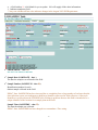
IALHazSiteOnlineSRPManagerIntro Last Updated: September 24, 2012 Welcome to IAL’s HazSite Online SRP Manager Manual. This manual has been updated to include the latest requirement from the Department of Environmental Protection (DEP) Site Remediation Program’s (SRP) Hazsite Electronic Data Deliverable (EDD). It will also demonstrate how IAL HazSite Online SRP Manager works with SRP EDD and be a helpful guide for creating an acceptable NJDEP SRP Electronic Diskette Deliverable. All the information provided in this manual is from the NJDEP web site located in: http://www.nj.gov/dep/srp/hazsite/docs/edi/index.htm http://www.nj.gov/dep/srp/hazsite IAL will provide you with the tab delimited text format which is the only acceptable format to submit electronic data to NJDEP with any or a sampling event starting on or after 1/1/2011. The IAL HazSite Online SRP Manager can be used to enter all site field data (i.e., Area of Concern identification, Latitude/Longitude or State Plane Coordinates, Ground Elev, Well Elev, Sample Type, Sample Method, Sample Note). You can also use Excel as an alternative to fill in all the necessary information. The benefit of using the IAL HazSite Online SRP Manager is to eliminate human error and provide an easy and simple way for data input. IAL HazSite Online SRP Manager can be accessed via our online portal at: http://www.ialonline.com. You may request an online user id and password by contacting our customer service department at (973) 361-4252 or by e-mail: [email protected]. You can access the NJDEP’s Electronic Data Submission FAQ’s web page for any technical questions @ http://www.nj.gov/dep/srp/hazsite/help/eds_faq.htm or you may call their SRP Help Desk at (609) 633-1380. We encourage clients to use DEP’s EDSA software to check all data entries to meet SRP requirements. You may download the new EDSA 7 @ http://www.nj.gov/dep/srp/hazsite/software/edsa/edsa.zip Thank you and good luck! Sincerely, Angela Chang Laboratory Information System Director Integrated Analytical Labs 1 A field with an ** is left blank for you to update. IAL will supply all the other information. Indicates mandatory field ** Any text with Brown font color indicates changes in the August 2012 SRP Requirement 1) DTST Table ~ Distribution Information Distribution Directory (DIRECTORY – char 8) Designates the subdirectory for file storage. IAL Note: If you change the folder name for the files, please enter the new folder name in this field. (We are using the IAL lab case number as the folder name) **Dataset Description (DESC – char 40) Description of the dataset being submitted **SRPID (SRPID – char 24) This is the SRP identification number. For Responsible Party sites, it is commonly referred to as the Case Number. For Publicly Funded sites, it is the 20 digit number, usually the EPA ID, beginning with "NJ". IAL Note: We will enter the SRP ID for you if you provide us with it on the chain of custody. EDSA7 Note: SRPID has been changed to accommodate identifiers that may be longer than the 16-character fields that were used prior to 2000. The New Jersey Environmental Management System (NJEMS) has made use of larger SRPIDs possible and EDSA7 has followed the NJEMS lead in order to facilitate integration of HazSite data to NJEMS data. **Primary Consultant (CONSULTANT – char 40) Name of the primary consulting firm collecting samples and compiling reports. 2 1) DTST Table Cont. **Phase (PHASE – char 12) The remedial phase (per Tech Rules) for which the samples are being collected. EDSA7 Note: Valid Values for Phase are the followings, PI = Preliminary Investigation; SI = Site Investigation; RI = Remedial Investigation RA = Remedial Action; RAO = Remedial Action Outcome; MP = Monitoring Permit **Dataset Status (STATUS – char 10) This field indicates the status of the dataset preparation, whether Active, Pending or Packaged. In HazSite this field is automatically updated while the user enters data. For .WK1 and .DBF files, all datasets submitted should have a status of Packaged. Status Definitions: Active = The dataset is being worked on; it has not been packaged for submission to NJDEP. Pending = This dataset is not active and has not been packaged for submission to NJDEP. Packaged = This dataset has been formatted and is ready to be submitted to NJDEP. IAL Note: You should select “Packaged” in the dropdown box. TRANSMIT (TRANSMIT – char 1) This field indicates the method of data transmittal. **Submit Date (SUBMITDATE – date 8) Date the dataset was submitted to SRP, use the MM/DD/YYYY format. Package Identification (PACKNUM – numeric 2) A package (dataset) identification field. LEAVE BLANK. **Contact Name (CONTACTNAM – char 60) Name of the person responsible for submitting the dataset. **Contact Telephone (CONTACTTEL – numeric 10) Telephone of the person responsible for submitting the dataset, use ######## format (no dash). **Contact Tel Ext (CONTACTEXT – numeric 10) Telephone extension of the person responsible for submitting the dataset, use ######## format. **Contact Email (CONTACTEMA – char 254) Email address of the person responsible for submitting the dataset. EDSA7 Note: These fields have become necessary due to elimination of case managers and implementation of the LSRP program. Since there are no longer case managers to run hard media submissions of EDSA data, SRP is implementing a system, whereby the EDD can be e-mailed to [email protected] and automatically run by the automated EDSA7 program. 3 A field with an ** is left blank for you to update. IAL will supply all the other information. Indicates mandatory field ** Any text with Brown font color indicates changes in the August 2012 SRP Requirement 2) HZSAMPLE Table SRPID (SRPID – char 24) IAL Note: You will not see this field. Sample Date (SAMPDATE – date ) The date the sample was collected in the field. Sample Number (SAMPNUM – char 50) Identification number for each distinct sample collected in the field. EDSA7 Note: SAMPNUM has been increased due to complaints from a large number of end-users that the data collection system was inadequate to hold large identifiers often used in field collection. Often such identifiers were placed into the FIELDID field, resulting in problems because this field is intended to be a unique identifier of the location for a sample point in the field. Sample Time (SAMPTIME – char 25) The time the sample was collected. EDSA7 Note: SAMPTIME has been changed to accommodate a Time string. 4 2) HZSAMPLE Table Cont. **Duplicate (DUPSAMP – char 1) Indicate if this is a duplicate sample, check off using check box provided. **Matrix (MATRIX – char 15) Indicate the matrix represented by the sample. EDSA7 Note: Valid Values for Matrix are the followings, Air, Blank, Elutriate, Ground Water, Other, Product, QC Air, QC Soil, QC Water, Rinsate, Sediment, Soil, Soil Gas, Solid, SPLP Sediment, SPLP Soil, Surface Water, TCLP Sediment, TCLP Soil, TCLP Waste, Waste, Wipe IAL Note: We will default to Surface Water for an Aqueous Sample and Soil for a Soil Sample. If there is another matrix, you must select the proper matrix. Field ID (FIELDID – char 20) The FIELDID is the commonly used identification of the sample location. For example, monitor well 1 may be identified as MW-1; soil sample 3 may be identified as SS-3. It is suggested that abbreviations correspond to the Sample Types field. **AOC ID ( AOCID – char 60) Area of Concern identification (text designation or number). EDSA7 Note:The AOCID is intended to allow the evaluation of HazSite data by individual Areas of Concern (AOCs). This field can be used to tie into any identically-named AOC found in NJEMS. If the AOC is found in NJEMS, details related to the AOC can be linked to the HazSite data. While this is not a required field, it should be useful to the Responsible Party to demonstrate that certain areas of a site have been completed (or partially completed), possibly decreasing the potential Remedial Priority System (RPS) score for the site. One of the potential uses for AOCs with additional information is to determine whether particular AOCs might be excluded (or partially excluded) from consideration in the RPS. Details from the New Jersey Environmental Management System (NJEMS) indicate that an AOC has been excavated to a particular depth. If samples can be tied to this AOC by AOCID, they would be excluded from consideration in RPS scoring because they have been excavated. **Latitude / Longitude (LAT_DEGREE – char 10 decimals 7, LAT_MINUTE – char 8 decimals 5, LAT_SECOND – char 6 decimals 3) (LON_DEGREE – char 10 decimals 7, LON_MINUTE – char 8 decimals 5, LON_SECOND – char 6 decimals 3) Latitude and longitude of each sample point. Each is a separate field, with a total of six fields represented here. EDSA7 Note: Latitude and Longitude fields have been changed to accommodate Decimal Degrees and Decimal Minutes because it has come to SRP’s attention that many data preparers have been attempting to submit data in these formats by distributing the result into the existing fields. This results in data points that are often far from the intended location. The Latitude and Longitude fields have traditionally collected Degrees, Minutes, Decimal Seconds data and will continue to default to that format. If, however, the data being sent to SRP uses one of the acceptable alternate formats, the submitter must input Decimal Degrees or Decimal Minutes in the COORDMETH field. 5 2) HZSAMPLE Table Cont. **State Plane (SP_X – char 14, SP_Y - char 14) New Jersey X,Y Coordinate System location for each sample point. NOTE: LATITUDE/LONGITUDE and STATE PLANE COORDINATES Datum must be obtained from NAD83. According to the Tech Rules, when data is submitted to the SRP, all sample locations are to be located using an absolute coordinate system, such as Latitude/Longitude and State Plane Coordinates. The Tech Rules also require that a NJ licensed surveyor locate all monitor well locations. Although all soil samples do not have to be surveyed, the coordinates of each sample must be a reasonable approximation to the actual location (within 5 feet of actual location). It is recommended that at least one sample point on a site be surveyed and a grid developed to locate all sample points in Latitude/Longitude or State Plane Coordinates. NOTE: EITHER the Latitude/Longitude fields or the State Plane Coordinate fields are mandatory fields requiring data entry. The only exception to this rule at this time is if the sample being analyzed is a "blank", and this must be noted in the Matrix field in the Sample file. **Depth (Top) (DEPTH_TOP – char 6) ! Do not include units (e.g. Feet) Depth (in feet) to the top of the sample, measured from the ground surface. EDSA7 Note: Field that is required for both Soil and Ground Water samples. This field is measured in feet, with a maximum of 2 places after the decimal point. For soils, DEPTH_TOP is measured from the ground surface to the top of the sample. For ground water sampling, record the depth to the top of the water level (after purging) from the ground surface (measured from the surveyed mark on the well casing and subtracting the distance to the ground surface). For ground water sampling, when taking a sample from the bottom of a well (i.e., DNAPL sampling), use the DEPTH_TOP field to record the depth to the point where the sample was taken from the ground surface (measured from the surveyed mark on the well casing and subtracting the distance to the ground surface). For potable wells or other non-applicable instances, enter "N/A." **Depth (Bottom) (DEPTH_BOTM – char 6) ! Do not include units (e.g. Feet ) Depth (in feet) to the bottom of the sample, measured from the ground surface. EDSA7 Note: Required only for Soil sampling. This field is measured in feet, with a maximum of 2 places after the decimal point. It is used to indicate the endpoint of the soil boring segment that was collected for the sample in question. **Ground Elev (GROUNDELEV – char 6) The height of the sample point in feet above mean sea level (MSL). May be estimated based on a single surveyed reference point, such as a monitor well. **Well Elev (WELL_ELEV – char 6) Note the well elevation in feet above mean sea level (MSL). 6 2) HZSAMPLE Table Cont. **Sample Type (SAMPTYPE – char 15) Indicate the type of sample collected. EDSA7 Note: Valid Values for Sample Type are the followings, Air Stripper, Ambient, Background, Blank, Blank – Amb Air, Blank – Field, Blank – Trip, Building Floor, Building Wall, Chip, Debris, Drum, Effluent, Flowing Water, Influent, Injection Well, Interior Air, Leachate, Monitor Well, Near Slab, Other, Portable Well, Rad Sample, Sanitary Sewer, Sediment, Septic System, Sludge, Soilgasexterior, Standing Water, Storm Sewer, Subslab, Subsurface Soil, Sump Basement, Sump Excavation, Surface Soil, TCLP, Temp Pile, Temp Well, Test Pit, Wipe, Well Packer Date to Lab (DATETOLAB - date) Date the sample was delivered to the laboratory for analysis. **Sample Method (SAMPMETHOD – char 15) Sampling method or instrument by which the sample was physically obtained (i.e. hand auger, split spoon, etc.) **Sample Note (SAMPNOTE – Memo 10) Memo field. To be used for explanation of "Other" in the Sample Matrix and Sample Type fields. May also be used to further explain Sample Method. SUBMITDATE - date The date the package was submitted to SRP. (MM/DD/YYYY) IAL Note: This is the same field in the DTST Table. You will not see this field here. QA/QC (SDG) (QAQC – Char 15) Internal field for NJDEP use only. LEAVE BLANK EDSA7 Note: QAQC has been expanded to 15 characters. This expansion of the field is intended to hold the Sample Delivery Group (SDG) number for Field/Laboratory EDD identification purposes. **Coordinate Method (COORDMETH – Char 15) New field used to track the coordinate method. EDSA7 Note: Two methods are currently acceptable for input to this field: DECIMAL DEGREES = Degrees with up to 7 decimals. DECIMAL MINUTES = Degrees + Minutes with up to 5 decimals. If either of these methods is used the lower fields must not be filled out! 7 2) HZSAMPLE Table Cont. **Coordinate Note (COORDNOTE – Char 10) New field that allows the user to convey useful information related to how data points were collected. EDSA7 Note: For sampling data, three methods are currently recognized: Survey: At least one point was collected by surveying from a known point. GPS: Geographical Positioning System – Electronically collected from a GPS Unit. Dig. Image: Using Geographical Information System (GIS) images such as orthophotoquads in ESRI’s ARC-Map application; NJGeoWeb or Google Earth. Points can be determined against Aerial Photography and input to datasets, usually with sufficient accuracy to meet SRP standards. **GW Depth before Purging (DEPTOGWBEF – Char 7) This field is a measure of the depth to ground water before purging a well. It is reported in feet above mean sea level. **GW Depth after Purging (DEPTOGWPOS – Char 7) This field is a measure of the depth to ground water after purging a well. It is reported in feet above mean sea level. **Top of Screen elevation (SCREENTOP – Char 7) This field is a measure of the depth to the top of a well screen (or packer interval or passive diffusion bag) in feet above mean sea level. **Bottom of Screen elevation (SCREENBOT – Char 7) This field is a measure of the depth to the bottom of a well screen (or packer interval or passive diffusion bag) in feet above mean sea level. **Well Permit Number (WELLPERMIT – Char 20) Well Permit Number is required field for Monitoring Wells. EDSA7 Note: The current Well Permit Number consists of 10 alphanumeric characters, with the following rules: If the well is unpermitted or grandfathered and does not require a permit use “NO PERMIT” in this field. All wells except for domestic wells pre-dating 1949 should have a valid permit. SRP Directory (SRP_DIR – Char 8) This field is used by SRP for cataloging datasets that come into the system. LEAVE BLANK Laboratory ID for Sample (SAMPLABID – Char 20) This field is used in conjunction with HZRESULT.LABID to track sample information. 8 A field with an ** is left blank for you to update. IAL will supply all the other information. Indicates mandatory field ** Any text with Brown font color indicates changes in the August 2012 SRP Requirement 3) HZRESULT Table (all required data have been provided from IAL) (SRPID – char 24) Sample Date (SAMPDATE – date) The date the sample was collected in the field. Required format is MM/DD/YYYY. Samp Num (SAMPNUM – char 50) Identification number for each distinct sample collected in the field, for a specific sampling day or episode. This field is used to relate samples in the Sample file to results in the Results file. There is a many to one relationship between Samples and Results. The sample number must match in the related results records. (Note distinction of the Sample Number from Field ID or Lab ID). Lab ID (LABID – char 20) Identification number given to the specific sample by the laboratory. Date Analyzed (TDANALYZE –char 20) Date the sample analysis was completed, it may now include both date and time of day. EDSA7 Note: This field was changed from a date field to a text field that contains the string associated with the typical Excel Date/Time Field. Lab Name (LABNAME – char 20) IAL Lab Cert # (NJDLABCERT – char 7) Laboratory Certification number, IAL is using 14751 as Cert #. Result Type (RESULTTYPE – char 1) A – Analyte, P – Parameter, T = Tentatively Identified Compound, S = Surrogate, I = Internal Standard Analyte / Parameter (ANALTPARAM – char 60) Indicate the Analyte or Parameter for which results are being presented. CAS (CAS – char 15) Chemical Abstract Service number. 9 3) HZRESULT Table Cont. Filt/Unfilt (FILTUNFILT – char 1) If an aqueous sample (ground water or surface water for example) was collected, indicate if the sample was filtered in the field. Enter "F" for filtered or "U" for unfiltered. Conc (CONC – char 12)Concentration/value of analyte, parameter or TIC. Soils data is to be presented in parts per million (ppm); water data in parts per billion (ppb). Units (CONCUNITS – char 15) Concentration units. The CONCUNITS field automatically defaults to ppm for soil and ppb for water. If entering the value for a parameter, enter the appropriate units for that parameter, or N/A if not appropriate. EDSA7 Note: EDSA7 no longer requires Concentration Units to be expresses in terms of parts per million (ppm) or parts per billion (ppb). This field should be left as it was submitted by the laboratory. Q (QAQUAL- char 7) Quality Assurance qualifiers. The standard qualifiers listed below shall be used when appropriate (extracted from NJDEP laboratory services contract). The field is not restricted to one qualifier. If a laboratory specific qualifier is used, the qualifier must be fully defined in the SAMPNOTE field. MDL (MDL – char 12) Method Detection Limit (per N.J.A.C. 7:18 regarding laboratory certification). If entering data in this field for a common parameter and there is no applicable MDL, enter N/A. Quant Type (QUANTTYPE – char 8) The lowest concentration above background noise level that an instrument can reliably detect. Acceptable entries and the order of preference is the Practical Quantitation Level (PQL), the Contract Required Quantitation Level (CRQL), or the Contract Required Detection Limit (CRDL), etc. If entering data in this field for a common parameter and there is no applicable result, enter N/A. Quant Level (QUANTLEVEL – char 12) The value of the PQL, CRQL, CRDL, etc. If entering data in this field for a common parameter and there is no applicable quantitation level, enter N/A. NOTE: Either the MDL or the QuantType/QuantLevel fields are mandatory fields requiring data entry for each Analyte or TIC for which results are being submitted. If results are submitted for a Paramaeter and there is no applicable MDL, Quant Type or Quant Level, enter N/A. Analysis Method (ANLYS_MTHD – char 35) This field identifies the analytical method used. The field must contain the method number/name preceded by the organization in which the test originated. If entering data in this field for a common parameter and there is no applicable analytical method, add N/A. Sample Delivery Group (QAQC – char 12) Sample Delivery Groups for Indoor Air requirements. 10 3) HZRESULT Table Cont. Uncorrected Conc (UNCOR_CONC – char 12) The concentration number expressed in instrument raw data, must include any adjustment for dilution. Uncorrected Unit (UNCOR_UNIT – char 15) Units of the UNCOR_CONC. EDSA7 Note: UNCOR_CONC & UNCOR_UNIT are both required fields for indoor Air sampling. These fields provide part of the data required by Methods for TO-15, TO-17 and NJDEP LLTO-15. Retention Time (RETEN_TIME – char 8) Retention Time Dilution Factor (DILUT_FAC – char 12) Report the dilution factor applied to the sample. Preparation Method (PREP_MTHD – char 35) Report the dilution factor applied to the sample. Cleanup Method (CLNUP_MTHD – char 35) This field identifies cleanup method used after extraction. EDSA7 Note: Cleanup Method is included to track various methods that may be employed to decrease interference of a non-target compound 11 Submitting HazSite EDD to DEP Step 1: Checking for all the required files SRP tab delimited (txt) Format, Each dataset (Folder) must include all three files: 1. DTST.txt 2. HZSample.txt 3. HZResult.txt Step 2: Checking Hazsite EDD Using EDSA7 (Electronic Data Submittal Application) The EDSA software is copyrighted by the New Jersey Department of Environmental Protection. The application is designed to assist regulated entities when submitting data in an electronic format to NJDEP. You can download this program through NJDEP’s web site: (Latest Version: 7.1.2, Updated on September 6, 2012) http://www.nj.gov/dep/srp/hazsite/software/edsa/edsa.zip EDSA User Manual can be found at http://www.nj.gov/dep/srp/hazsite/docs/edsa/ Step 3: Submitting Hazsite EDD through email After your HazSite EDD has passed the EDSA7 checker, you will need to 1. Attach all three files (see Step 1) to an email 2. In subject box, include the Preferred ID and the SRPID, separated by a comma. 3. In the body of the email, you must include the following information a. Case Name b. Directory c. Submit Date d. Description 4. Send the email with attachment to [email protected]. For technical issues and assistance, please call the SRP Help Desk (609) 633-1380 12 Site Remedation Project Information Worksheet INTERNAL USE ONLY SRP ID: ____________________________________ (SRPID - Text 24) PROJECT: DATE: ____________________________________ / / by ______________________ (Signature) DATASET TABLE (DTST.txt) Project Description: (DESC - Text 40) Consultant: (CONSULTANT – Text 40) Phase: PI SI RI RA RAO Other ________________________ (PHASE – Text 12) Status: Active Pending Packaged Main Contact Info: (Responsible Party for EDD) Name: ____________________ (CONTACTNAM - Text 60) Tel: ________________ ext _______ (CONTACTTEL - Text 10, # only, no dash) (CONTACTEXT - Text 10) Email: ________________________ Submit Date: / (CONTACTEMA - Text 254) / Note: This information worksheet is provided for consultant internal use only. 13 MP