1
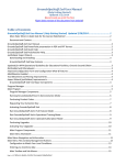
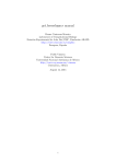
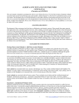
APPENDIX A Department of Environmental Quality DCR-DNH Data Explorer Website Training 4-19-07 Draft User Manual http://www.vanaturalheritageexplorer.org UserName:________________________ Password:_________________________ 2 3 4 Terms and Conditions for Use of the Natural Heritage Data Explorer Website and Associated Virginia Natural Heritage Program Services Access to the Virginia Natural Heritage Data Explorer Website is available by subscription only. All users of this website are required to be either registered subscribers to this website, or authorized representatives of registered subscribers to this website. As a condition of registration, all subscribers are required to sign a form guaranteeing their adherence, and the adherence of all persons whom they shall authorized to use this website, to these Terms and Conditions. All users of this website, whether direct subscribers or authorized representatives of subscribers, are required to adhere to these Terms and Conditions. • Data License • Other Guidelines • Project Review Services License for Use of Digital Natural Heritage Resources Information The Virginia Department of Conservation and Recreation's Natural Heritage Program (DCR) hereby grants authorized users of the Natural Heritage Data Explorer Website a revocable license to use the data displayed on this website. Use of these data is subject to the following conditions: 1. The license is nonexclusive and revocable. 2. The license is nontransferable, and any attempted transfer is void. 3. The license conveys no rights for Licensee to release or distribute these data, or derivative works containing these data, in any electronic/magnetic or machine-readable form. 4. Licensee will identify "Virginia Department of Conservation and Recreation, Natural Heritage Program" as data source on any map or publication using DCR data. If format permits, Licensee will also include the date provided. 5. Licensee will provide DCR with a list of any reports or printed materials prepared using Natural Heritage Program data, and will provide a sample copy of such material if requested by DCR. 6. Although DCR maintains high standards of data quality control, DCR makes no warranty as to the fitness of the data for any purpose, nor that the data are necessarily accurate or complete. 7. Licensee understands and acknowledges that these data are provided for planning and assessment purposes only. Specific projects or activities should be reviewed for potential environmental impacts with appropriate regulatory agencies. If ground-disturbing activities are proposed in the vicinity of indicated natural heritage resources, DCR will be contacted for a site-specific review of the project area. 8. Licensee understands and acknowledges that release of precise species locations may threaten natural heritage resources. Licensee shall take reasonable precautions to ensure the security of species locations. 5 9. If there are subscription service charges, or any other agreements between DCR and Licensee for sharing costs incurred by DCR in making the data available, Licensee shall pay agreed charges within 30 days of being billed by DCR. 10. Licensee understands and acknowledges that the accuracy of these data is time-limited. Licensee agrees to seek an update to DCR-provided natural heritage information if a significant amount of time passes before it is utilized. 11. Licensee will indemnify and hold DCR and its officers and employees harmless against any claims by third parties arising out of the use by Licensee of the data provided hereunder. 12. This License is the entire agreement between the parties with respect to the subject matter hereof. It shall be construed in accordance with the law of the Commonwealth of Virginia and may be amended only in writing signed by both parties. Other Guidelines for use of Natural Heritage Resources Data Further information about DCR's digital data policies is available at the following links: • • • Guidelines Regarding Use of Digital Data Guidelines Regarding Provision of Natural Heritage Resources Data to Clients Who Request Data only for Listed T&E Species Guidelines Regarding Display of Natural Heritage Resources Data At Public Meetings Natural Heritage Project Review Services Project Review. This service assesses the potential impacts of a specified project on natural heritage resources. DCR research will identify all documented occurrences of natural heritage resources from the project area (including an appropriate buffer based on the scope of the project), and may also identify potential species occurrences. If potential impacts are identified, the response will list key natural heritage resources with scientific and common names, Natural Heritage Program rarity ranks, federal and state protected status information, with recommendations for resource protection. Certain Data Explorer clients will be assessed a charge for projects submitted for review. These charges will be assessed as follows: $60/site, plus an additional charge of $35 for 1-5 occurrences and $60 for 6 or more occurrences. Data requests are usually filled within 30 working days of receipt. Priority responses will incur an additional $200 surcharge, and can generally be completed within 3 working days. Most natural areas in Virginia have not been thoroughly surveyed, and new occurrences of plant and animal species continue to be discovered. For this reason, DCR's response or data cannot be considered a definitive statement on the presence, absence or condition of biological elements on a particular site. Heritage reports summarize the existing information known to DCR at the time of the request and should not be substituted for on-site surveys required for environmental assessments. For more information about DCR's Natural Heritage Program, including order forms and certain downloadable data, visit our Internet Homepage www.dcr.virginia.gov/dnh. 6 For additional Virginia Natural Heritage information services, visit our website www.dcr.virginia.gov/dnh/infoservices.htm or contact the NH Project Review Unit at 804-371-2708 or [email protected]. Guidelines Regarding Use of Digital Data The mission of the Virginia Department of Conservation and Recreation's Natural Heritage Program (DCRNH) is to conserve Virginia's biodiversity through inventory, protection, and stewardship. DCR-NH is statutorily responsible for the creation and maintenance of a natural heritage resource database. DCR-NH recognizes that accurate scientific data are critical to sound decision-making that will impact natural heritage resources, and encourages the use of its data, in a variety of formats, for activities that further the conservation of Virginia's biodiversity. Natural heritage locational data are sensitive because their inappropriate use, even by well-meaning parties, may result in harm to natural heritage resources we seek to protect. For this reason, DCR-NH monitors the use of natural heritage resource data it collects and maintains, in order to ensure that those uses are appropriate for the benefit of natural heritage resources. The availability of natural heritage resource data digitally presents special concerns. The digital format vastly increases the ability to transfer data and to use the same set of data in a variety of applications. This data mobility can be positive when it multiplies the beneficial uses of the data. But it also represents a risk with regard to issues of inappropriate data use and distribution. All use of digital data provided by DCR-NH, whether to public agencies or private parties, is governed by the DCR-NH License for Use of Digital Data, which dictates conditions for use, requires periodic update, and proscribes distribution of data to third parties. The DCR-NH License must be signed before any use of natural heritage data in digital form, whether those data were provided directly by DCR-NH or were transformed into digital form from paper reports, tables, or maps provided by DCR-NH. The Natural Heritage Project Review Coordinator, in consultation with the Natural Heritage Director and the Natural Heritage Data Provision Committee, is responsible for determining who may receive digital data from DCR-NH. Questions and comments may be addressed to the NH Project Review Coordinator, S. Rene Hypes. Guidelines Regarding Provision of Natural Heritage Resources Data To Clients Who Request Data Only for Listed T&E Species The mission of DCR's Natural Heritage Program is to conserve Virginia's biodiversity. We focus on natural heritage resources, which are defined as the habitat of rare, threatened, or endangered plant and animal species, rare or state significant natural communities or geologic sites, and similar features of scientific interest. One of our responsibilities, to which we devote regular and substantial resources, is the determination of what natural heritage resource elements are rare or significant enough to require our attention. This process, which results in our published Rare Animals and Rare Plants lists, follows wellestablished and well-reviewed procedures. We appreciate the importance of the legal protection afforded certain rare species by the U.S. Fish and Wildlife Service and the Virginia Departments of Game and Inland Fisheries and Agriculture and Consumer Services through the federal and state Endangered Species Acts, but we also recognize that political considerations in the assignment of certain species to protected status result in an imperfect and incomplete list of species receiving protection. Species that have been formally listed as Threatened or Endangered are included among our elements of concern, but our interests are broader. Our Project Review function is an important opportunity for us to provide our various clients with information that can help to protect natural heritage resources. We are not a regulatory agency, and rely on our clients to act voluntarily to enhance natural heritage resources or to mitigate against the potential 7 negative impacts of their activities. We have established agreements with certain regulatory agencies the U.S. Fish and Wildlife Service, the U.S. Army Corps of Engineers, the Virginia Department of Environmental Quality - to use our data as part of their regulatory processes, and we are appreciative that these agencies incorporate information about all natural heritage resources, not just listed threatened and endangered species. For various reasons some clients who seek our data to review potential impacts to their projects only request information about listed species. We believe that our mission is best served by providing these clients with appropriate data for the full range of natural heritage resource elements, not just listed species. Clients are not under any obligation to us to review or use this information, but in some cases they may find this information useful in suggesting ways to enhance project benefits or reduce negative impacts. Therefore our responses for all project review requests will include information about potential impacts to all natural heritage resources, and clients will be charged for this information according to our fee schedule. Guidelines Regarding Display of Natural Heritage Resources Data At Public Meetings Points or polygons representing the exact location of natural heritage resource occurrence locations may not be displayed to the public under any circumstances. Features of the Natural Heritage Resources Screening Coverage (boundaries of conservation sites, stream conservation units, general location areas associated with natural heritage resources, and cave/karst proxy conservation sites) may be displayed to the public only subject to the following conditions: • Boundaries must be shown with and in the context of other project data, and not as a separate map featuring natural heritage resource features. • Only Tier I attributes can be displayed, which are limited to site name, site type, biodiversity significance rank, acreage, and whether a federal or state listed species is present. • No information about specific natural heritage resource locations can be displayed, including names of species associated with specific conservation sites or stream conservation units. • Natural Heritage Resources Screening Coverage boundaries can be made available only on hard copy or pdf maps, not in GIS-readable format. • Any maps showing NHR Screening Coverage boundaries must credit DCR and include the date of the most recent data update. • A copy of any map products displayed for or distributed to the public should be sent to DCR-NH's Project Review Coordinator; any maps or posters too large to copy for DCR-NH should be sent as an image file or described in detail. 8 Map Layers Natural Heritage Resources NH Element Occurrences - source: VA DCR, Division of Natural Heritage Visible to Tier 3 users and available through queries to Tier 2 users. Elements are plants, animals and exemplary natural communities, which are tracked by the Virginia Natural Heritage Program due to their rarity. An Element Occurrence is the location of a single extant habitat containing one or more individual elements. Each occurrence is represented by a polygon indicating its known location. The polygons are intended to indicate the full known aerial extent of the occurrence, modified to account for the locational uncertainty of the source data. At this time many records are represented by point locations with circular buffers of size that varies according to the locational precision of the source data, though DCR-NH is actively working to use extensive field records and the expertise of our field staff to convert these circles into more informed, reliable polygons. NH Screening Layer - source: VA DCR, Division of Natural Heritage This layer can be seen queried at the Tier 2 level and viewed at the Tier 3 level. There are three separate components to the NH Screening Coverage: • Conservation Sites represent key areas of the landscape worthy of protection and stewardship action because of the natural heritage resources and habitat they support. Conservation sites are polygons built around one or more rare plant or animal, or significant natural community or geological feature. Sites are designed to include the element and, where possible, its associated habitat, and buffer or other adjacent land thought necessary for the element's conservation. For rare aquatic species we define Stream Conservation Units (SCUs), which identify stream reaches that contain aquatic natural heritage resources, including upstream and downstream buffer and tributaries associated with this reach. There are almost 2000 terrestrial and SCU site records in the Conservation Sites coverage; these sites encompass all viable, recently-verified element occurrences documented in our databases. Conservation Sites and SCUs are given a biodiversity significance ranking based on the rarity, quality, and number of natural heritage resources they contain. Conservation Sites can be used to identify land management needs and protection priorities. They can also be used as a screening tool, to identify potential conflicts with development activities, and they can be used for proactive planning to ensure that development projects successfully avoid or enhance natural heritage resources. • General Location Areas for Natural Heritage Resources represent the approximate locations of documented natural heritage resource occurrences that were not incorporated into Conservation Sites, either because they are poor quality, their location was not precisely identified, or they have not been reverified in over 20 years. These approximate locations, marked with a one-mile-diameter circle, are included in the Screening Coverage because they indicate areas with relatively high potential for natural heritage resource occurrences to be redocumented. Depending on the apparent suitability of local habitat, DCR-NH may recommend biological surveys when reviewing projects that intersect these locations. Some general location areas are not circular polygons. For these records a review of recent aerial photography in conjunction with known habitat needs for the element identified potential habitat might exist within the limits documented in the original occurrence. Karst Screening Areas represent regions of karst topography that harbor significant cave communities and Natural Heritage Resources. In most cases karst areas involve a series of hydrologically connected caves and cavities that span a large area. Each • 9 significant karst feature is buffered with a 3 km radius. These regions are in the process of being re-evaluated and delineated as more detailed Conservation Sites. Diabase Screening Layer – source: VA DCR, Division of Natural Heritage This is a digital representation of diabase soils with potential for Natural Heritage Resources. Diabase soils were isolated from county soil survey data and NRCS soils data. These soils were further analyzed using digital orthophotography (VA Basemap Imagery), and areas where the landscape appeared to be disturbed or currently under heavy cultivation were removed. In Northern Virginia, diabase supports occurrences of several global and state rare plant species: earleaf foxglove (Agalinis auriculata, G3/S1/NLNL), no longer track , purple milkweed (Asclepias purpurascens, G4G5/S2/NL/NL), bluehearts (Buchnera americana, G3G4/S1/NL/NL), downy phlox (Phlox pilosa, G5T5/S2/NL/NL), stiff goldenrod (Oligoneuron rigidum var. rigidum, G5/S2/NL/NL), and marsh hedgenettle (Stachys pilosa var. arenicola, G5/S1/NL/NL). Reference Layers Digital Raster Graphic (DRG) Grid – source: U.S. Geological Survey Reference grid for the USGS Digital Raster Graphics. This dataset includes the DRG boundaries, index numbers, and corresponding topographic quadrangle names. USGS Placenames – source: U.S. Geological Survey Includes all features labeled on Virginia’s USGS Topographic Quadrangles. Trails - source: VA DCR, Division of Natural Heritage, NPS, USFS, Appalachian Trail Conference Currently includes the Appalachian Trail, and trails located in many State Parks, the National Forest and Shenandoah National Park. VDOT Roads – source: Virginia Department of Transportation Virginia Department of Transportation maintained statewide geo-spatial databases on its maintained highway transportation network. NHD Streams – source: U.S. Geological Survey The National Hydrography Dataset (NHD) is a comprehensive set of digital spatial data that contains information about surface water features such as lakes, ponds, streams, rivers, springs and wells. Within the NHD, surface water features are combined to form "reaches," which provide the framework for linking water-related data to the NHD surface water drainage network. These linkages enable the analysis and display of these water-related data in upstream and downstream order. The NHD is based upon the content of USGS Digital Line Graph (DLG) hydrography data integrated with reach-related information from the EPA Reach File Version 3 (RF3). The NHD 10 supersedes DLG and RF3 by incorporating them, not by replacing them. Users of DLG or RF3 will find the National Hydrography Dataset both familiar and greatly expanded and refined. http://nhd.usgs.gov/ Managed Conservation Lands - source: VA DCR, Division of Natural Heritage Public and private conservation and recreation lands in Virginia. Includes properties protected by Virginia Outdoors Foundation easements, lands managed by state and federal natural resource agencies, land trust holdings and others. http://www.dcr.state.va.us/dnh/conslandindex.htm Digital Raster Graphic (DRG) Grid – source: U.S. Geological Survey Reference grid for the USGS Digital Raster Graphics. This dataset includes the DRG boundaries, index numbers, and corresponding topographic quadrangle names. NWI Wetlands – source: U.S. Fish and Wildlife Service National Wetlands Inventory. This data set represents the extent, approximate location and type of wetlands and deepwater habitats in the conterminous United States. These data delineate the aerial extent of wetlands and surface waters as defined by Cowardin et al. (1979). http://www.nwi.fws.gov/ Boundaries Data Group Subhydrologic Units - source: EPA/DCR Division of Soil and Water Conservation The boundaries of the 494 hydrologic units in Virginia at the 14 digit level of detail. This dataset covers the whole state and these units are the immediate subsets of the 11 digit level of hydrologic units in Virginia. Developed for finer watershed planning work in the state than the 11 or 8 digit level of hydrologic unit allows. This level is the basis for Virginia's non-point source pollution assessment and ranking. It is the official statewide hydrologic unit delineation for water quality reporting. 8 Digit USGS Watersheds – source: US Geological Survey The United States is divided and sub-divided into successively smaller hydrologic units, or watersheds, which are classified into four levels: regions, sub-regions, accounting units, and cataloging units. The hydrologic units are arranged within each other, from the smallest (cataloging units) to the largest (regions). Each hydrologic unit is identified by a unique hydrologic unit code (HUC) consisting of two to eight digits based on the four levels of classification in the hydrologic unit system. http://water.usgs.gov/GIS/huc.html Physiographic Provinces - source: VA DCR, Division of Natural Heritage A physiographic province is a landform region, an area delineated according to similar terrain that has been shaped by a common geologic history. Each province is characterized overall by its elevation, relief, lithology, and geologic structure. 11 Planning Districts (PDC) – There are 21 planning districts in Virginia and each is under the jurisdiction of a separate Planning District Commission. Virginia Counties – source: Environmental Sciences Research Institute (ESRI) County boundaries. These are set to turn on and off at the most appropriate map scale. States – source: Environmental Sciences Research Institute (ESRI) State boundaries. These are set to turn on and off at the most appropriate map scale. Base Layers VBMP Imagery – source: Virginia Geographic Information Network (VGIN) Virginia Basemap Imagery (1 meter resolution): True color digital ortho-photography for the State of Virginia. Derived from photographs taken in the spring of 2002 during leaf off conditions. These are set to turn on and off at the most appropriate map scale. 24K TOPO – source: United States Geological Survey Digital Raster Graphics – 1:24,000 scale digital versions of the USGS topographic maps. Features include contour lines, roads, streams, and many types of labels. These are set to turn on and off at the most appropriate map scale. 100K TOPO - source: United States Geological Survey Digital Raster Graphics – 1:100,000 scale digital versions of the USGS topographic maps. Features include contour lines, roads, streams, and many types of labels. These are set to turn on and off at the most appropriate map scale. Elevation – Shaded relief image for the State of Virginia. This image gives you a sense of orientation at a small scale. It’s colored based on the physiographic regions and shaded based on elevation. Mapservice Navigation and Use 12 Click on an area of the screen to learn more Menu Options: These menu options allow you to toggle between other specialized windows to perform searches, etc. • Draw Project for Review - Enter a project boundary and query for conflicts with Natural Heritage Resources. • Terms and Conditions - Explains the constraints on the use of this data. Menu Toggle - Click on Layer or Legend to toggle between a list of available datasets and a legend showing how the data appears (color, hatching, etc) in the map view. Map Layers • Map layers are grouped by type and each type can be hidden or expanded by clicking the + or -. • The active map layer will be highlighted in yellow. A layer can be turned on and off by clicking the check box. • Several layers are "scale dependent" meaning that they automatically turn on and off at certain scales based on the most appropriate scale for that layer. If a map layer's check box is greyed out then it can't be viewed at that scale. Turning map layers on and off: There’s a check box next to each map layer. Click this box to toggle the layer on and off. Some of the layers are "scale 13 dependent meaning that they are only available at certain map scales. This is done to maximize the performance of the natural heritage data explorer as some layers would take a log time to display and refresh at larger (more zoomed out) scales. Legend boxes are greyed out if a layer is unavailable at your current scale. Scale - Displays the scale of the map view (1 map unit = # units in reality). You can change this number if you need to view at a particular scale. Zoom to Lat/Long - Enter latitude and longitude in dd-mm-ss (degrees/minutes/seconds) to zoom to a specific location. Zoom to a particular map coordinate: At the bottom of the map window there are two boxes for entering X / Y coordinates. You must first choose your coordinate system: Lat/Long, UTM zone 17, UTM zone 18. Lat/Long coordinates must be entered as degrees, minutes, and seconds values with no spaces (ddmmss). UTM coordinates can be entered as 2 digit numbers and decimal places (ex: 32.567429). Hit enter and the map view will move to a new location with the coordinate in the center of the screen. 14 Buttons - Buttons are used to navigate around the map view, query datasets, and submit project areas. Zoom to view a feature more closely. Click once in the map view or draw a box containing an area of interest. Zoom out to see a larger area by drawing a box or clicking on the map view. Pan, or move the viewable area by holding the mouse button dragging. Zoom to all features in all map layers. Zoom to the spatial extent of the active map layer View the previous screen View the next screen The select feature button allows you to create an irregular shape to select features. Draw a shape by clicking points on the screen and double click to perform the selection. Any features of the active theme (the one highlighted in yellow) that intersect the shape will be listed in the results window. The line select button allows you to draw a line to select features of the active theme. Search for a feature Buffer selected features - use this tool to select features within a certain distance of the selected features. Clear the selected features of the active theme. Identify a feature in the active data layer by clicking on it. Measure a distance on the map by clicking two or more points and double clicking to finish. Delineate an area as a polygon. This will not be used for project review, only map making. This will not be used for project review, only map making. Add a label by clicking on the map view and entering text. Delete all labels added by the user. Create a printable version of the map view. Click the button and when the print preview page opens press the Page Setup button. Set the print settings to Landscape orientation with 1" margins all the way around. This will apply to all subsequent prints during the same map session. Enter the help screen Please note during anytime you may exit the DNH on-line subscription service by using the back button. Search for a certain feature in a layer 1. Click on the search tool button . 15 2. Select a layer to search by using the drop down button 3. Enter text in search field 4. Click on search 5. Results are returned and options are available to view details view of each record or zoom to the feature in the map . 6. Reset button will clear value. Finding your Area of Interest Method 1. Zoom to a map coordinate 1. Locate the X and Y coordinate boxes at the bottom of the map view. 2. Choose a coordinate system: Lat/Long, UTM zone 17, UTM zone 18. Lat/Long coordinates must be entered as degrees, minutes and seconds values with no spaces (ex. 364534). UTM coordinated can be entered as 2 digit numbers and decimal places (ex:32.567429). Use the tab key to move between lat/long fields. 3. Click GO and the map view will move to the new location with a star representing the entered coordinates Method 2. Search for and zoom to a Place Name: 1. Press the Search button 2. Select USGS Placenames layer from the pulldown menu 16 3. Enter a name or part of a name in the Feature_na field: eg. Clinch will find any placename with Clinch anywhere in the name: Clinch Valley College or Middle Fork Clinch River. Then press Search. A results window will open showing the matches (example below). You can then use the info from Feature type and County fields to determine your area of interest. Once you find it, press the Zoom to icon to go to that location. 4. Method 3. Zoom to a known USGS quadrangle 1. Press the Search button 2. Select DRG Quad grid layer from the pulldown menu 3. Enter a name or part of a name in the NAME field: eg. north will find any quadname with ‘north’ anywhere in the name: Disputanta north or North View. You can also enter the USGS quad number in the Quadno field. Then press Search. A results window will open showing the matches (example below). Press the Zoom to icon zoom to that quad. It will be centered in your view frame with a shaded blue outline. to 17 View USGS Topographic maps and aerial photography: All basemap layers are located in the base layer group of the table of contents. At certain scales these images are available for viewing (see above for explanation) and each layer can be turned on and off by clicking the box next to it. Enter a project boundary for project review 1. Locate the area of interest on the 24K quadrangle and zoom in to a scale of 30,000 or less. You cannot pan once you start drawing the project boundaries. 2. Click on the draw project boundary button: 3. Draw the project boundaries by clicking and dragging the mouse, clicking at each change of direction. You cannot edit this polygon, so if you make any mistakes, double-click to end the polygon, then hit the Clear Features button to delete it and start again. 4. When you have entered the last point, double click with the mouse to close the polygon and a window will open up allowing for entry of information about the project. Enter all required fields and a valid e-mail address. 5. Click “submit” button at the bottom of the open window. 6. A project boundary will appear in red labeled with project name. All users will receive a PDF report listing Natural Heritage Screening Coverage features within 2 miles of the project boundary and a map showing the project 7. location. If a natural resource is within the search area a generated PDF map and report will automatically be emailed to the DCR-DNH for review and to the subscriber. If there are no resources within the search area, a boilerplate “no find” letter will be e-mailed to the subscriber. 18 Make a Map with text labels At any time, you can print what you see in your view, or you may customize the view by adding additional desired layers and labels. If you wish to digitize your own area of interest, use the draw polygon button to draw your polygon by clicking and dragging the mouse, clicking at each change of direction. You cannot edit this polygon, so if you make any mistakes, double-click to end the polygon, then hit the Clear Features button to delete it and start again. You can add labels by clicking on the Add label tool , then clicking in the polygon you just drew and entering text in the dialog box that opens. This will be added with a dot on the screen You will see the size, in acres, of your polygon on the status line of the browser window. This polygon will persist until you press the Clear Features button . When you are finished, press the Print button . Enter a title and description for the map in the dialog box that opens. Then press Print. You may get the following message: An activeX control on this page might be unsafe to interact with other parts of the page. Do you want to allow this interaction?. Click yes. A print Preview window will open as shown on the left below, click the Page Setup icon as shown by the arrow, and set the paper orientation to Landscape and the map margins to 1” all around for the map to print correctly. These settings will persist for your session. 19 Specified Distance of Other Find Features within a Features For example, you wish to find Lands within some distance of a Managed Conservation road. Make and using VDOT Roads layer active, then select a road by the Line or Polygon select tool. Choose the Buffer tool In the dialog that opens, select Managed Conservation Lands from the pulldown menu. Enter your buffer distance, you are limited to 2 miles or less. Select your buffer units, miles, feet or meters from the pulldown menu. A buffer will be drawn around the road and any intersected Conservation Lands will be highlighted and popped up in a results table. You can then zoom to each selected Land and/or see the detailed information on a land by pressing the button. If you close the results window you can recall it by pressing the Results tab on the menu so long as you have not done a new buffer or search. Scales for viewing different layers: LAYER EO NH Screening Layer Diabase Screening Layer Dye Inputs Monitor Points Dye Trace Vectors DRG Quad Grid Min Scale Don't show layers when zoomed out beyond 750000 750000 475000 500000 500000 500000 250000 Max Scale - Don't show layers when zoomed in Beyond 62500 62500 62500 10000 20 LAYER Trails NHD Streams NWI Wetlands Min Scale Don't show layers when zoomed out beyond 750000 500000 64000 Max Scale - Don't show layers when zoomed in Beyond 110000 Printing a map: When using the Print option in the GUI; after clicking the Print icon when the print preview page opens, press the Page Setup button, and set print settings to Landscape orientation with 1” margins all the way around. This will hold for subsequent prints during the same session. 21 Troubleshooting Tips ⇒ Please make sure that you have attended website training or have signed up for a future training. This will help in understanding our information, using the application and providing useful information when trouble shooting with DCR staff. ⇒ When your project does not submit or you see an error message, please verify or test the following settings or steps prior to contacting Natural Heritage Data Explorer Support at [email protected]. Also please screen capture the error message so it can be sent electronically to DCR-DNH. Text Size: When setting text size for the internet the size must be medium or smaller to properly view the application Medium text: 22 Large text: IE Settings: Check the Internet Explorer Settings (IE Settings) are correct. (See pages 2-4 in manual) or http://www.vanaturalheritageexplorer.org/siterequirements.htm . Draw Project for Review: After zooming into the project location at a 1:30,000 scale or less, right click the DRAW FOR PROJECT REVIEW tab in the upper left hand corner of the view. Do not click any other buttons. Draw the project polygon using single click for vertices/corners and double click to finish drawing the polygon. Please note if you are not using this tab or are using the draw polygon button the project will not be submitted for review. Drawing the Project Boundaries: When drawing your project boundaries do not cross the polygon lines. This will cause the project submittal to fail. Please note only one polygon can be submitted at a time for review. Entering Project Information: Do not enter characters such as &, <, > into the project information fields when submitting the project. This will cause the project submittal to fail and cause an error 23 message to pop up on the computers screen (see below). Please note when entering the project information, each field limit is 256 characters. Entering more characters in any one field will cause the project submittal to fail. ISP Server: When using this application make sure that there are no email blockers such as spam blocker, pop up blockers, or blacklists on the ISP server. This may cause the PDF report emails to be placed into a junk mail folder instead of being sent to the e-mail address entered in the project submittal form. If you are not receiving a confirmation email then most likely DCR-DNH is not receiving the project in their email mailbox. Please verify the GIS.TIMMONS.COM website has been added to your server’s trusted domain list. Please note: The PDF report is sent from gis.timmons.com not dcr.virginia.gov. Timing Out: The website will time out for security reasons after 20 minutes of being idle. Please back out of the application using the back arrow for internet explorer and log in again. 24 Website Support: Send questions to [email protected]. 25 Project Submission Template Tier 2 What information is needed to submit for the proper review? • • • • • • Project name: give project # (if one is available) and/or the title of the project for reference Project description: what is being done at the project site Ex: residential subdivision Site conditions: what is present conditions at the project site Ex: rolling, intermittent drainageways that form headwaters Automatically generated: lat/long and agencies main contact. Information must be changed per person who is submitting project: contact name, agency name, street address, city ,state, zip code, phone, and fax Email: automatically prompts main contact for company, please change to reflect user submitting project, enter in your personal work email address. Your personal business email is where you will receive conformation of project submittal and report will be automatically sent to address entered Comments: this field is for important information that DCR-DNH would need for proper review Ex: wetland compensation, etc. 26