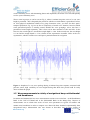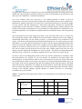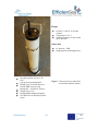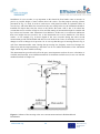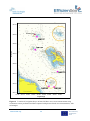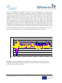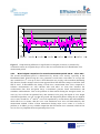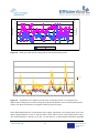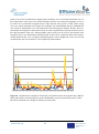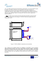
1
Title
Efficient, Safe and Sustainable Traffic at Sea
Acronym
EfficienSea
Document No. D_WP4_X_X
Document Access:
Public
Development of sea state registration and
analysis technologies
Contract No. 013
Part-financed by the European
Union
(European
Regional
Development Fund and European
Neighbourhood
and
Partnership
Instrument)
efficiensea.org
1
Part-financed
by
the European
Union
1
DOCUMENT STATUS
Authors
Name
Leo Käärmann
Aivar Usk
Alar Lepp
Tiit Pikpoom
Organisation
Estonian Maritime Administration
Cybernetica AS
Cybernetica AS
Cybernetica AS
Reviewers
Name
Kaisu Heikonen?
Organisation
FMA?
Approval of report
Name
Thomas Christensen
Document History
Revision
Date
efficiensea.org
Organisation
Signature
Date
DaMSA
Organisation
2
Initials
Revised
pages
Short description of
changes
Part-financed
by
the European
Union
2
Annotation
This document describes the Wave Height and Period Analysis Software solution called
WHAPAS that is intended for shore side calculation of significant wave height in marine
area where navigational buoys equipped with TelFiCon™ GSM/GPRS telematics units
implementing 3-axial acceleration measurement are deployed. Explanation of the operating
principles of the software components as well as results of testing conducted for buoy
calibration and wave height calculation algorithm verification are provided.
Limitation of Liability and Copyright Notice:
efficiensea.org
3
Part-financed
by
the European
Union
3
This User Manual is intended for providing guidelines for using the product that it was supplied with, and
does not represent a commitment on the part of the manufacturer for performance of any similar past or future
products. The information in this document is subject to change without prior notice in order to improve
product reliability, functionality, or design. While reasonable efforts have been made to ensure the accuracy of
this document, the manufacturer and distributors assume no liability resulting from errors or omissions in this
Manual. In no event will the manufacturer be liable for direct, indirect, special, incidental, or consequential
damages arising out of the use or inability to use the product or documentation.
This document contains proprietary information protected by copyright that is to be used only by persons to
whom the document has been legally supplied in the course of obtaining the product that is described within.
All rights are reserved: any unauthorized copying, disclosure, distribution, printing, translation, or use of this
information in full or in part without prior written permission of the manufacturer is prohibited.
ekta™, TelFiCon™ and TeViNSA™ are registered trademarks of Cybernetica AS, with the latter two pending
at the time of publication of this document.
Cybernetica AS, 2011
efficiensea.org
4
Part-financed
by
the European
Union
4
Table of Contents
1
Introduction .......................................................................................................................... 7
1.1
1.2
1.3
1.4
2
Scope and purpose ......................................................................................................... 7
Background ...................................................................................................................... 7
Abbreviations used ......................................................................................................... 8
References ....................................................................................................................... 9
System Summary ................................................................................................................. 9
2.1
2.2
System Configuration ..................................................................................................... 9
WHAPAS Architecture ................................................................................................... 10
2.2.1
Data Retrieval Software Component ...................................................................... 11
2.2.2
Wave Height Calculation Software Component ....................................................... 12
2.2.3
Results Output Software Component ..................................................................... 12
2.2.4
Configuration Management Software Component ................................................... 13
2.2.5
Log Management Software Component ................................................................. 14
2.2.6
Settings Synchronisation Software Component ....................................................... 14
2.3
3
WHAPAS Operation....................................................................................................... 14
Calculation of Significant Wave Height ........................................................................... 15
3.1
3.2
Calculation Algorithm ................................................................................................... 15
Verification Results ....................................................................................................... 17
APPENDIX 1 Reference measurements for WHAPAS software calibration............................ 19
1.1
General approach to ocean waves .................................................................................. 20
1.2
Depth dependence of wave parameters......................................................................... 22
1.3
Dependence of wave parameters from morphometry of the coastline ..................... 23
1.4
Shape of the wave shape and particularly wave shape in the Baltic Sea ................. 25
1.5
Wave measurements in vicinity of navigational buoys at Karbimadal and
Kuradimuna ...................................................................................................................................... 26
1.6
Measurement equipment .................................................................................................. 28
1.7
Conversion of measured sub-surface pressure into surface elevation spectra ........ 32
efficiensea.org
5
Part-financed
by
the European
Union
5
1.8
Comparison of wave heights measured with two different methods ......................... 36
1.8.1
Wave heights comparison for first measurement period: 1.-23.09.2011 .................. 36
1.8.2
Wave heights comparison for second measurement period: 20.10 - 15.11.2011 ... 40
1.9
Wave height comparison experiment general outcome ............................................... 43
References........................................................................................................................................ 45
APPENDIX 2 Different buoy types, equipped with 3D acceleration sensors ......................... 46
APPENDIX 3 TelFiCon E9263.1 product data and user manual .............................................. 47
3.1
SCOPE .................................................................................................................................. 47
3.2
SAFETY INFORMATION ..................................................................................................... 47
3.3
DESCRIPTION ..................................................................................................................... 47
3.4
ELECTRICAL SPECIFICATIONS ........................................................................................ 49
3.5
CONTROL AND COMMUNICATION SPECIFICATIONS .................................................. 50
3.6
PHYSICAL SPECIFICATIONS............................................................................................. 51
3.7
ENVIRONMENTAL CONDITIONS OF USE ....................................................................... 52
3.8
INSTALLATION AND ELECTRICAL CONNECTIONS ....................................................... 52
3.9
CONTACT INFORMATION OF THE SUPPLIER ................................................................ 55
efficiensea.org
6
Part-financed
by
the European
Union
6
Wave Height and Period Analysis Software - WHAPAS
1
1.1
Introduction
Scope and purpose
This document describes the Wave Height and Period Analysis Software solution called
WHAPAS, explaining the purpose, architecture, and functionality by software component.
Description and results of the verification experiments performed in 2010 are provided.
The WHAPAS software system is intended for shore side calculation of significant wave
height in the marine areas where navigational buoys equipped with TelFiCon™
GSM/GPRS telematics units implementing 3-axial acceleration measurement are deployed.
WHAPAS calculates the wave heights based on the buoy acceleration data and individual
parameters of equipment used (sensor calibration and buoy model) and stores them in a
database or files. WHAPAS output data is pre-formatted to be utilised for provision of an eNavigation service of broadcasting the calculated wave heights over the AIS shore side
network using AIS M8 hydro-meteorological data messages. This requires application of an
external software component developed by Cybernetica AS – AIS Router with
Hydrometeorological Data Module.
Wave period is not analysed by the current implementation of WHAPAS.
The WHAPAS software was developed by Cybernetica AS in cooperation with the
Estonian Maritime Administration and the Marine Systems Institute of the Tallinn
University of Technology within the framework of the Efficient, Safe and Sustainable
Traffic at Sea (EfficienSea) project that was part of the Baltic Sea Region Programme
2007-2013.
1.2
Background
Measurement of the significant wave height on the waterways with following timely
provision of this information to the mariners is an important aspect of marine navigation
safety while cost-efficient implementation of it is not an easy task. Dedicated wave height
measurement equipment is expensive to procure and maintain while emerging satellite
based methods are not expected to provide reasonable resolution neither in time nor in
coastal area coverage. Marine weather stations are often deployed in locations where actual
open sea wave parameters are influenced either by nearby structures or shallow water
depth. Although the measurement of wave height using accelerometric sensors installed
onboard regular navigational buoys results in a significant trade-off between precision of
the results and additional power consumption of the remote system when compared to
dedicated wave following buoys, it can provide usable estimation of sea states in near real
time when data processing is performed at the server side. The main difference of the wave
height measurement enabled by the TeViNSA / WHAPAS solution is utilisation of the
existing infrastructure deployed for remote monitoring of visual aids to navigation and AIS
message broadcasting with value adding functionality, without the need for additional
investments into the existing hardware infrastructure. Resulting additional communication
efficiensea.org
7
Part-financed
by
the European
Union
7
and energy costs are expected to remain insignificant in comparison with benefits from
near real time in-situ wave height measurement.
1.3
Abbreviations used
Abbreviation
AIS
Explanation
Universal Automatic Identification System used for marine navigation safety
related ship-to-ship, ship-to-shore and shore-to-ship digital communications
based on the standard ITU-R M.1371
AtoN
Aid to Navigation; refers either to a marine visual aid to navigation site
in general, or to a set of electro-optical systems of an AtoN outstation
for provision of visual light signalling.
cron
Time based task activation application in Unix-like operating systems
DTD
Document Type Definition; description of an XML document
FFT
Fast Fourier Transform; an algorithm for calculation of spectra.
GPRS
General Packet Radio Service; a GSM cellular network service for
TCP/IP based data communications
GSM
Global System for Mobile Communication; a digital
communication network standard (900/1800 MHz in Europe)
HTTP
Hypertext Transfer Protocol is used for serving of digital content to
standard web browsers (based on RFC-1945).
IPv4
Internet Protocol version 4; the current digital data exchange protocol
with 32 bit addressing of hosts on the Internet.
JAR
Java Archive; a file format for compressing of several Java files into a
single file.
Java
An object-oriented high-level computer programming language
developed by Sun Microsystems
JVM
Java Virtual Machine; runtime environment for executing software
applications created using Java
MSI
The Marine Systems Institute of the Tallinn University of Technology
SQL
Structured Query Language; standard format for performing data
queries from relational databases.
TCP/IP
Transmission Control Protocol/Internet Protocol for reliable
connection less digital packet data transmission used in the Internet
(based on RFC 793)
TelFiCon
Telematics Field Controller; a GSM/GPRS/GPS based AtoN telematics
hardware module developed and manufactured by Cybernetica AS
TeViNSA
Telematics for Visual Navigation Situational Awareness; a set of
software and hardware components developed by Cybernetica AS for
remote control and monitoring of remote AtoN site systems,
measurement and broadcasting over AIS of relevant e-Navigation data
efficiensea.org
8
radio
Part-financed
by
the European
Union
8
Abbreviation
WHAPAS
1.4
Explanation
Wave Height And Period Analysis Software
References
1. Telematics Controller Telficon E9261. Instructions for Use. Cybernetica AS, 9261.004
2. GPRS keskus. Tarkvara arhitektuur. Cybernetica AS, N-B76250-13
3. AIS Router – a module for routing AtoN-specific AIS messages M8, M12, M14 and
M21. Cybernetica AS, Y-399-28
4. Hydrometeorological Data Module for AIS AtoN Router. Owner's Manual. Cybernetica
AS, Y-399-44
2
2.1
System Summary
System Configuration
The WHAPAS system is intended for installation either on a single institutional server or a
constellation of distributed servers for operation as an autonomous „back office―
application, requiring no user intervention unless re-configuration is needed. The software
has practically no user interface, it analyzes the input data retrieved from a pre-configured
source locations in the local area network, and places the calculation results to preconfigured locations for use by other applications.
The WHAPAS software is hardware independent; it was developed in Java SE 6
environment (by Sun Microsystems) and will run on all platforms supporting the
corresponding runtime environments. For the purpose of guaranteeing high availability, it is
recommended to run the core software component responsible for data analysis on a
dedicated server hardware with GNU Linux compatible operating system since fast
calculation of wave height from multiple sources can become resource demanding.
WHAPAS is supplied in a single Java Archive (JAR) file that contains all necessary
components. The WHAPAS JAR file contains a tool called HSQL Database Manager
(http://hsqldb.org/doc/guide/apf.html) that is intended for facilitating the work with the
configuration database.
For meaningful use, in addition to TCP/IP network WHAPAS needs the following external
infrastructure to be operational and properly configured:
TeViNSA system software with AtoN equipment settings and operational
information database;
TelFiCon telematics units mounted on navigational buoys, regularly uploading buoy
acceleration data to the TeViNSA server;
AIS Router with Hydrometeorological Data Module and a functional shore side AIS
network for broadcasting of M8 messages to the mariners.
Both input and output data of WHAPAS are in the form of files and database records. Due
to the fact that WHAPAS operates practically in the background, outside of human
efficiensea.org
9
Part-financed
by
the European
Union
9
operator’s attention, it is recommended to establish automated monitoring of WHAPAS
performance – specifically in case when AIS M8 broadcasts are activated. WHAPAS is
equipped with plug-ins for integration with open source software for online computer
network monitoring Nagios (http://www.nagios.org/).
2.2
WHAPAS Architecture
The WHAPAS (Wave Height And Period Analysis Software) software distribution consists
of six separate software components that are operated either on a single server, or on
several distributed computers:
Three core software components responsible for retrieval of the input data from
TeViNSA server, calculation of significant wave height, and exporting of the results
in relevant formats;
One external software component for the management of WHAPAS settings,
working with a dedicated database;
Two supporting software components for logging and synchronisation of WHAPAS
settings with the TeViNSA database.
Figure 1. Architecture of WHAPAS
Architecture of WHAPAS is provided in Figure 1 with core component names shown in
bold. All three core components are fully autonomous software modules that share only
the settings and log management components. Data exchange between the components
is arranged by the means of TCP/IP (IPv4) socket interfaces shown in Figure 1 with
large arrows.
efficiensea.org
10
Part-financed10
by
the European
Union
2.2.1
Data Retrieval Software Component
The Data Retrieval Software Component (DRSC; shown as „Import― in Figure 1) is
responsible for retrieval of acceleration data from binary data files uploaded by TelFiCons
deployed at seas and saved by the TeViNSA Core. The information in those data files
represents acceleration values measured at the outputs of a three-axial accelerometer sensor
and compressed in proprietary lossless format. In addition to checking whether a new data
file is available, the DRSC performs integrity checking of the files, relevance checking by
the TelFiCon serial number in the file, orientation correction of the data axes in accordance
with the specifics of TelFiCon mounting onboard a particular buoy, and preliminary
filtration based on data file length and time stamp. Simplified diagram of the DRSC is
provided in Figure 2.
Figure 2. Flow diagram of DRSC operation
The DRSC performs checks to discover new data files becoming available with the interval
found in WHAPAS settings, by default once every second. Two methods are available that
can be employed simultaneously: checking based on TeViNSA database, or based on a
efficiensea.org
11
Part-financed11
by
the European
Union
listing of acceleration data files that has relevant files added to the end once an acceleration
data file is complete. If a file is compliant to pre-set conditions, it is opened, decoded, and
the acceleration data vectors are handed over to the Wave Height Calculation Software
Component (WCSC).
Depending on the needs dictated by the configuration of TeViNSA components, WHAPAS
allows installation of several DRSC modules in parallel on several hosts of a local area
network, with all of them feeding the decoded acceleration data to a single WCSC.
2.2.2
Wave Height Calculation Software Component
The Wave Height Calculation Software Component (WCSC, shown as „Calculation― in
Figure 1) is responsible for calculation of an average wave height in the location of a
navigational buoy from which the acceleration data received from a DRSC originate as a
single task. On a single server, a number of WCSC modules equivalent to the number of
processor cores may be run in parallel. Simplified work algorithm of a WCSC is provided
in Figure 4, with the algorithm described in more detail in section 3 .
The WCSC waits until acceleration data is received from some of the Data Retrieval
Software Components. Upon receiving a batch of new acceleration data, WCSC checks for
data integrity and validity, then forwards valid data to a software module that analyzes the
three axes and establishes a common vertical acceleration axis which is arranged „upright―
using mathematical methods. Heel angle of this derived vertical acceleration axis will
change very little in time, allowing to calculate the wave height and period.
The method used for wave height calculation can be unique for each acceleration data
source (buoy) when prepared this way. At this time WHAPAS uses only a single FFT based
analysis method.
Once the wave height (and period) are calculated, the corresponding values are transferred
to the Results Output Software Component (ROSC).
Figure 3. Flow diagram of WCSC operation
Similarly to the DRSC’s, it is also possible to operate several correspondingly configured
WCSC’s on separate computers on a computer network, having them feeding the
calculation results to a single ROSC.
2.2.3
Results Output Software Component
The Results Output Software Component (ROSC, shown as „Output― in Figure 1) is
responsible for interpolating all wave height data received from WCSCs to a 10 minute
time interval, filtering the data, and formatting the output values in accordance with the
input specification of the Hydrometeorological Data Module of an AIS Router that
regularly scans the output directory of the ROSC. In addition, output data can be saved to
the TeViNSA AtoN database and even to a specified CSV file.
efficiensea.org
12
Part-financed12
by
the European
Union
A simplified diagram of the ROSC is provided in Figure 4. Wave height values received
from the WCSC are processed to evaluate their correctness and if found to be correct, the
values are transferred to the post processing software module (Figure 5) that divides the
data set using a discrete step of 10 minute time intervals, applies buoy specific individual
correction factors, and filters the results in the form of averaging over a two hour time
period to suppress the noise. The correction factors for a specific buoy need to be derived
in advance from the comparison of a set of wave height calculation results obtained from
WHAPAS with time-matched results of nearby reference measurements recorded during
the calibration process of a buoy. In addition to the hydrodynamic properties of a specific
buoy hull, the calculation results may be influenced by the length and type of the mooring,
water depth in the deployment area, and distance from coastal structures. WHAPAS
provides the capability to prepare a set of reference wave height measurement data set time
matched to the results of its own calculated results for calibration of a buoy: the correction
factors can be derived by comparing resulting two data sets. When use of reference wave
height data is enabled by the settings, such data file at a pre-set location is processed to
interpolate the wave height values for obtaining a data set suitable for direct comparison
with the wave height values calculated by WHAPAS based on received buoy accelerations.
Such reference values are not corrected or filtered; the results are recorded in accordance
with the current WHAPAS settings.
2.2.4
Configuration Management Software Component
The Configuration Management Software Component (CMSC, shown as „Configuration―
in Figure 1) is responsible for WHAPAS configuration and management of configuration
settings. In addition, it is used for reading the initial configuration settings from
efficiensea.org
13
Figure 4. Flow diagram of ROSC operation
Part-financed13
by
the European
Union
Figure 5. Operations inside the wave height processing module
corresponding files and the command prompt, changing the configuration settings based on
direct user input in terminal mode, and updating of the current active settings with new
settings.
2.2.5
Log Management Software Component
The Log Management Software Component (LMSC, shown as „Logging― in Figure 1) is
responsible for management of all WHAPAS logs, including saving of log records received
from software components, and regular archiving of log files based on pre-configured time
intervals or file size. In addition, LMSC monitors the WHAPAS operation for malfunctions
and significant events, providing the assigned maintenance personnel with timely e-mail
notifications.
Software components responsible for configuration and logging can service the core
components only within the limits of a single Java virtual machine. Therefore, in case when
WCSC and ROSC are run on a single server but on separate JAVA virtual machines, they
need separate instances of CMSC and LMSC to be run on corresponding virtual machines.
2.2.6
Settings Synchronisation Software Component
The Settings Synchronisation Software Component (SSSC, shown as „Synchronisation― in
Figure 1) is a part of code responsible for copying of AtoN equipment data from the
TeViNSA database into the configuration database of WHAPAS. Apart from the other
WHAPAS components, SSSC is completely separated from the rest of WHAPAS
components and is only activated manually to update the WHAPAS settings database when
such need emerges. Such setup is optimal due to the fact that all the changes at TeViNSA
database affecting WHAPAS operation are performed manually anyway. Nevertheless,
when fully automated activation of SSSC with a pre-configured time interval is considered
necessary, such arrangement can be made by the use of external scripts like the cron service
of Unix-like operating systems.
2.3
WHAPAS Operation
WHAPAS has no user interface; it is started up on the server hosting the software either by
an automated start-up script run at the operating system start-up in case of regular use, or in
manual mode for temporary use by entering WHAPAS at the command prompt of the
GNU/Linux operational system console.
To request the help information on command line parameter options, the operator must
enter at the command prompt:
WHAPAS –h
Configuration settings of WHAPAS are maintained in an XML file that is not accessible for
direct editing, changes can be implemented either by logging into the CMSC terminal, or
by copying the settings from TeViNSA database.
efficiensea.org
14
Part-financed14
by
the European
Union
A detailed manual with all commands, configuration options and XML configuration file
contents is provided to system administrators.
3
Calculation of Significant Wave Height
3.1
Calculation Algorithm
Calculation of significant wave height performed by WHAPAS is based on the assumption
that the analysed waveform is a good approximation of a sinusoidal wave. This allows
calculating the amplitude of the waveform using the following formula:
(1)
where:
– Time instance
– Frequency of oscillation
– Peak amplitude of oscillation
– Oscillating variable at the time instance
Time derivative of this formula provides velocity of the level displacement:
(2)
Since the (significant) wave height is described by the wave’s peak-to-peak amplitude
(crest to through), double extent of the amplitude provides the actual displacement:
(3)
where:
–
Displacement of the water level
Inserting the result of formula 3 into formula 2 results in the following:
(4)
Time derivative of formula 4 provides instantaneous acceleration:
(5)
where:
–
efficiensea.org
Instantaneous acceleration
15
Part-financed15
by
the European
Union
The components before the „sin― in formula 5 present the amplitude of the acceleration;
since we have no need to monitor the changes of the acceleration in time, the following
simplification can be used:
(6)
where:
–
Amplitude of the acceleration
Expressing the displacement from formula 6 results in:
(7)
The amplitude of acceleration can be expressed as follows:
(8)
where:
–
Acceleration of free fall
–
Value of acceleration in g units measured by a TelFiCon
mounted onboard a navigational buoy
After inserting the expression 5 into formula 7 and performing necessary elementary
calculations, we arrive at the following simplified association between the measured
acceleration and the corresponding water level displacement (significant wave height):
(9)
The remaining analysis is performed by applying spectral analysis (FFT) with selected
window functions to the selected subsets of the three arrays of acceleration values (data
arrays) received from the TelFiCon units mounted onboard navigational buoys. In addition,
due to the different low-pass filtering behaviour of different buoy types, a set of correction
factors will be applied to compensate for deviations in several wave height ranges. Such
correction factors are in fact buoy model parameters that present a simple description of
dynamic behaviour of a specific buoy type. Currently, the only way of determining these
factors is conducting of reference measurements utilising precision wave height
measurement equipment deployed by the side of the buoy subject to calibration for
acquisition of statistically sufficient amount of reference points over the range of wave
heights, and deriving the sufficient amount of wave height range dependent correction
factors from the comparative analysis of the results of both measurements to bring the
calculation results up to acceptable wave height estimation uncertainty. WHAPAS settings
database accepts definition of several range related correction factors per each AtoN
subjected to wave height analysis. In addition, a capability to introduce new calculation
methods and then select them for use with new AtoN objects is foreseen.
efficiensea.org
16
Part-financed16
by
the European
Union
3.2
Verification Results
Tests were conducted in cooperation with the Marine Systems Institute of the Tallinn
University of Technology for calibration of the algorithm for wave height calculation for
specific navigational buoy, and for verification of the results of server side calculation. Two
measurement sessions were conducted by the MSI with precision wave height
measurement sensors deployed at the close vicinity of buoys No. 157 „Kuradimuna W―
and No. 186 „Karbimadala W― in September and November 2010, resulting in 22195
reference points taken at 10 minute intervals. The measurement results of the reference
sensor used by the MSI are expected to provide approximately 0.05m measurement
uncertainty. At first the results of reference measurement were used to determine buoy
specific correction factors in an incremental fitting process. Next, the factors producing
smallest differences compared to reference data were applied at the analysis of the same set
of buoy acceleration data at the input of WHAPAS and the final deviations from reference
values were noted.
Due to the different measurement and averaging methods utilized by the reference sensor
and the TelFiCon sensor, non-synchronized sampling as well as a positioning difference of
about 20m, certain differences in results were expected and are not necessarily presenting a
measurement uncertainty. Differences between the reference values and best fit values
calculated by WHAPAS with application of correction factors derived from the same
experiment are presented in Table 1.
efficiensea.org
17
Part-financed17
by
the European
Union
Table 1. Differences between wave height reference measurement and WHAPAS results
Percentage of
calculation results
within the maximum
difference
Maximum difference in calculated significant wave height
[m]
Range: 0.0 m to 2.0 m
(21794 reference points)
Range: 2.25 m to 5.0 m
(401 reference points)
68.27%
0.29
0.63
90.00%
0.37
0.78
95.00%
0.41
0.86
95.45%
0.41
0.87
99.73%
0.53
1.10
Graphical distribution of the differences of the calculated wave heights in comparison with
reference measurements conducted by the MSI is provided in Figure 6 in two ranges, under
and over a 2m wave height.
Figure 6. Relative distribution of differences in height between the wave heights calculated
by WHAPAS and wave heights obtained for the matching time periods by a reference
sensor.
efficiensea.org
18
Part-financed18
by
the European
Union
APPENDIX 1 Reference measurements for WHAPAS software
calibration
Waves are probably the most important factors influencing navigation conditions at the sea as well
as other basins usable for navigation throughout the year. Waves are generated by wind and by
knowing wind forecast the prognosis for wave field could be derived. This works well in the open
sea. However, in coastal sea-areas number of other factors influences the realization of wave
situation in certain weather conditions, just to name the most important of these factors – bottom
topography and coastline morphology, currents, presence of the ice, etc. Generally it’s so that the
closer to the coastline wave field gets, the more complicated, and dynamics of waves become more
active. Latter is the case for shipping, especially for navigation of smaller ships, also for anchoring
safety of bigger ships and ship maneuvers. The Baltic Sea has a very complicated shape, elongated
to NE-SW direction Baltic Proper, W-E directional Gulf of Finland, almost round-like Gulf of Riga
– and all these bordering the Estonian coastal sea. It’s obvious that the same wind generates very
different wave fields in particular sea areas. From navigational point of view wave information is
essential; for smaller ships navigation is prohibited with certain wave height, for bigger ships
restrictions for certain maneuvers apply. Therefore, collection of information about wave conditions
is very important. Most of historical wave data and information are however based on visual
observations at hydro-meteorological coastal stations and some limited amount observations form
on board of ships. All these visual observations are probably satisfactory to get basic wave
statistics, but can’t be applicable operationally. There exist some limitations in space and time wave
measurements out in the sea from last couple of years, but these are really snapshots of a couple of
weeks long in some points and can’t be enough to describe wave field. On the other hand numerical
modeling is improving very fast and principally applicable as in hind- and forecast mode in order to
support safe navigation with wave information. Still, one has to be careful using wave models in sea
areas with complicated morphometry, as is the case for Estonian coast. In open sea, yes, most of
wave models work good, but in coastal sea measurement, data is definitely needed first to set up the
model, then validate; the best results will come if data is assimilated into the model continuously.
As navigational buoys are installed in a number of locations along the Estonian coast and also the
open sea, and most of cases into navigationally critical places, an idea to use those as wave
measurement platforms naturally came into use. On the other hand, buoys are technologically
equipped with acceleration sensors for other purposes, but could still be used for estimates of wave
parameters. There are several problems: slightly different shape of the buoys, their different weight
etc. but this didn’t stop us from trying the idea.
At first approach effort was undertaken to estimate parameters of wave field around the certain
navigation buoys and then try to find most suitable algorithm to get wave data from acceleration
sensor output. For that purpose two measurement campaigns were planned, both using two pressure
sensor based wave gauges in two different locations near the navigation buoys, in Karbimadal and
Kuradimuna. From these two Karbimadal is a more inner location in the Muuga Bay and
Kuradimuna reflects wave regime in the open Gulf of Finland much better. Also, attempt to cover
two different seasons – September as late summer and October- November as autumn is taken into
account in case of measurement campaigns. Current report gives first overview of some basic
aspects of ocean waves’ importance in context of proposed measurement technology and applying
acceleration sensors. Then description of measurements campaigns performed to get set up and
efficiensea.org
19
Part-financed19
by
the European
Union
validation data from new technology of wave estimation. Finally, first evaluation to the method of
wave estimation with navigation buoys applying acceleration sensors is given through comparisons
with pressure wave gauge results.
1.1 General approach to ocean waves
In fluid dynamics, wind waves or, more precisely, wind-generated waves are surface waves that
occur on the free surface of oceans, seas, lakes, rivers, and canals or even on small puddles and
ponds. They usually result from the wind blowing over a vast enough stretch of fluid surface.
Waves in the oceans can travel thousands of miles before reaching land. Wind waves range in size
from small ripples to huge rogue waves. When directly being generated and affected by the local
winds, a wind wave system is called a wind sea. After the wind ceases to blow, wind waves are
called swell. Or, more generally, a swell consists of wind generated waves that are not — or hardly
— affected by the local wind at that time. They have been generated elsewhere, or some time ago.
Wind waves in the ocean are called ocean surface waves.
Five factors influence the formation of wind waves:
Wind speed
Distance of open water that the wind has blown over (called the fetch)
Width of area affected by fetch
Time duration the wind has blown over a given area
Water depth
All these factors work together to determine the size of wind waves: the greater each of the
variables, the larger the waves. Waves are characterized by:
Wave height (from trough to crest)
Wavelength (from crest to crest)
Wave period (time interval between arrival of consecutive crests at a stationary point)
Wave propagation direction
Waves in a given sea area typically have a range of heights, not a single number for height. For
weather reporting and for scientific analysis of wind wave statistics, their characteristic height over
a period of time is usually expressed as significant wave height. This figure represents an average
height of the highest one-third of the waves in a given time period (usually chosen somewhere in
the range from 20 minutes to twelve hours), or in a specific wave or storm system. Given the
variability of wave height, the largest individual waves are likely to be about twice the reported
significant wave height for a particular day or storm.
In the context of wave dynamics, the Baltic Sea wave field is characterized by very complex nature,
much more complex than in the ocean for example. This stems for multiple factors. The Baltic Sea
is divided into number of sub-basins – Gulf of Finland and Riga, Bothnian Bay, Baltic Proper etc.
Each one of these sub-basins has its own distinctive wave regime (Jönsson, 2002). A pronounced
seasonal variability also exists, where waves are higher in autumn and winter and lower in spring
and summer (Jönsson, 2002). The wind regime is frequently anisotropic, especially in the Baltic
Proper, thus giving rise to predominated wave propagation directions also (Soomere, 2003). In
efficiensea.org
20
Part-financed20
by
the European
Union
wintertime nearly half of the Baltic Sea is commonly ice covered, in hard winters even up to 85%.
Presence of ice of course modifies, again, wave field remarkably.
As an example of wave fields in the Baltic Sea, two situations are presented on Fig 1 and 2. The
first one represents the average significant wave height integrated over all months and years during
the period 1970-2007. These results are presented by Räämet and Soomere (2010). Largest average
significant wave height is found at the Baltic Proper, where it is up to 1m.
Contrary to average situation, in the windstorm Gudrun which attacked the Baltic Sea countries on
8-9 January 2005, significant wave height grow over 9m in the southern Baltic Proper and was over
7m in Estonian territorial sea, according to SWAN wave model results (Fig.2). In both cases
regions of highest waves are located more or less in the same places, one of those West from
Estonian Archipelago. Pattern in the Gulf of Finland is slightly different as filed of average wave
heights show secondary maximum in the middle of the Gulf, which is averaging result of westerly
and easterly winds creating waves. In reality wave field decay in the Gulf is going easterly in case
of westerly winds and roughly vice versa with easterly winds, as seen also on Fig 2. Measurement
location in our case lay well inside the Gulf of Finland, reflecting more wave conditions of the open
Gulf in Kuradimuna and Muuga bay wave field in case of Karbimadal.
Figure 1 Average significant wave height in the Baltic Sea. Color bar of the scale is in cm. Results
from the wave model WAM.
efficiensea.org
21
Part-financed21
by
the European
Union
Figure 2 Significant wave height during storm Gudrun on January 9th, 06:00 UTC. Results from
wave model SWAN. Scale on color bar is in meters.
In next chapters from 1.1 to 1.3 we give answers to some most important questions needed to be
clarified in order to establish a link between the wave parameters measured with acceleration
sensors on board of navigation buoys and wave parameters registered with pressure based probe as
well as modeling results showing wave field realizations in certain sea areas at given time moments,
forced by atmospheric conditions.
1.2 Depth dependence of wave parameters
Three physical processes contribute to the evolution of wind waves over basin of variable depth and
size. The first is the generation of wind waves by wind; secondly the nonlinear transfer of wave
energy between harmonics which allows for the generation of longer waves and lastly, the
dissipation which is the sum of whitecapping, bottom friction and depth induced wave breaking.
The dissipation due to whitecapping is always present, no matter how deep the sea is. However,
depth induced breaking and bottom friction becomes important only in shallow waters and also
depends on the wave period. The bottom slope is important as well.
Numerical experiments with the wave model SWAN indicate that in Estonian coastal regions
bottom friction becomes important in water depths less than 30m, and depth induced breaking in
water depths less than 10 m (Alari, Raudsepp and Kõuts 2008; Alari and Raudsepp 2010)
efficiensea.org
22
Part-financed22
by
the European
Union
1.3 Dependence of wave parameters from morphometry of the coastline
Morphometry of the coastline in certain area together with depth profile are major components
forming the local wave field realization. Number of other circumstances drive the wave field
variability, most important of those is of course wind, but also currents, presence of ice or algae
alter the wave parameters, depending on their intensity, accordingly as well. There can’t be sorted
out universal methods or algorithms giving general key to solve those local peculiarities of wave
field. That’s the reason why, if it’s necessary, local wave field is modeled individually in the
interested area. Using real bottom topography and coastline, forcing (wind) can be both idealized,
to show wave field realization in extreme cases as well as real, to show natural evolution of wave
field and compare the model results with measurements. Before using local scale model in certain
sea area, validation and local set up of the model with in situ measurements is an essential
precondition in order to gain acceptable results. As particular example from Estonian coastal sea, a
numerical experiment with a phase resolving model COULWAVE (TTÜ Meresüsteemide Instituut,
2007) was undertaken in order to study the interaction between Naissaar harbor jetty and fast ferry
wakes. The results showed that the reflected wave did not propagate more than 200m from the
harbor constructions. In case of wind waves (which are shorter) and normal coastline (where
bottom dissipates much energy), the propagation of reflected wave is even more restricted. As
harbour jetty is a vertical wall in water, its wave reflecting features are much better than most of the
coastline, we can summarize that wave field is directly affected by coastline, wave reflection stays
inside the 200m zone.
As an example of the large scale alteration of wave field due to coastline, consider a wave field
realization in Tallinn Bay during a W storm. Naissaar Island not only damps waves (Fig.3), but the
underwater slope at the southern tip of the island refracts waves to an extent, where pure westerly
waves change their direction up to 90 degrees.
efficiensea.org
23
Part-financed23
by
the European
Union
Figure 3 Significant wave height in Tallinn Bay, as modeled with SWAN wave model. Arrows
indicate wave propagation directions.
A more localized impact of coastal morphology upon wind waves is seen on Fig .4 and 5. In the
former case the shoaling and depth induced breaking of wind waves is described, in the latter case
the wave reflection and diffraction near vertical wall. Note that the coast absorbs much of the
incoming wave energy and reflection is negligible.
efficiensea.org
24
Part-financed24
by
the European
Union
Figure 4 Wave shoaling and depth induced wave breaking at western coast of Tahkuna peninsula,
as seen aero photography (Estonian Land Board).
Figure 5 Complicated nature of multiply wave diffractions and reflections near Lehtma jetty, as
seen aero photography (Estonian Land Board).
1.4 Shape of the wave shape and particularly wave shape in the Baltic
Sea
Considering the shape of wave spectrum, the SWAN wave model can be used to accurately
reproduce the shape of the waves. Realization of certain wave spectrum is the sum of sine and
efficiensea.org
25
Part-financed25
by
the European
Union
cosine elementary waves with alternating phases and amplitudes, the actual wave field infrequently
resolve a pure elementary wave.
Waves come in groups, as can be seen on Fig. 6, where 10 minute long time series of in situ wave
height is presented – this is frequently the period for which wave information is generalized. In fact,
no solid physical mechanism behind wave group formation exists, yet alone for their spatiotemporal prediction. Fig. 6 gives an idea of complexity of actual wave situation, based on which
some generalized picture is actually created. Besides the wave groupings, waves also have a
pronounced crest-trough asymmetry. This is best seen at time moments of 180s and 285s. In the
first case, the crest height is 1.9m and the trough depth is -2.6m. In the second case, the crest height
is 1.2m and the trough depth is -2.3m. Almost all the asymmetries resemble ―holes in the sea‖
asymmetries, which in certain cases could pose a particular threat for navigation.
Figure 6 Snapshot of in situ wave package during 10 minute long time sequence, measured with
pressure sensor, high variability in wave heights during that short time period could be easily
observed from the graph.
1.5 Wave measurements in vicinity of navigational buoys at Karbimadal
and Kuradimuna
In summer and autumn 2010 two wave measurement sessions were carried out – at the Kuradimuna
Bank in the Gulf of Finland and at the Karbimadal Bank in the Muuga Bay. Purpose of
measurements was to obtain time series of basic wave parameters as typical for summer and
autumn wind conditions in order to compare wave data with these obtained experimentally from
navigational buoys. Measurement sites were chosen so that these were in close vicinity of
efficiensea.org
26
Part-financed26
by
the European
Union
navigation buoy reporting wave parameters for same measurement periods. Two measurement sites
should also represent typical conditions inside the coastal bay (Karbimadal in the Muuga bay) and
more open sea conditions as recorded in Kuradimuna.
Two wave recorders LM2 were used (Fig 7), the working principle of which is based on
measurement of pressure at fixed position of the probe with absolute pressure sensor (Keller Ltd.).
Instrument is installed 5-8m below sea surface (Fig. 8) and measured pressure is converted to height
of water column with 4Hz sampling rate, while water temperature variations are automatically
compensated by sensor electronics. All data is recorded in internal memory, which is SD type card.
Pressure sensor based measurements of wave parameters are used primarily for validation of wave
calculation algorithm, wave height data originated from the acceleration sensor of the navigational
buoys.
Wave measurements were made during two periods, 31.08–30.09.2010 and 20.10–17.11.2010, first
one representing summer wind conditions and second autumn. Limiting factor for the length of
measurement period here was the memory capacity, as measurements were performed in 4Hz
regime, 2 Hz mode would prolong the measurement period about twice. In order to get best possible
data quality, we went for denser recording rate. In other words, having the sampling frequency four
times per second, the endurance limit for one sampling session is approximately three weeks. The
depth was 20 meters at both sites, the wave recorders were mounted five meters below the water
line. Wave recorder was kept at the given level in the water column, with a float, but as sea level
changes, then the depth of the instrument also wasn’t constant – this feature was filtered during the
data processing. A mark buoy was added to simplify the recovery of the buoy stations (Fig 8).
In order to ensure an unchangeable position of the buoy stations in difficult sea conditions, what
both measurement sites actually are, an extra anchor was attached to the main anchor. The
connecting rope was left floating to make it easier to find and recover the buoy station if the mark
buoy should get lost. Both wave recorders were placed west of the aforementioned banks (Fig 9), in
the vicinity of the west navigational buoys that were equipped with acceleration sensors. The bank
name and necessary information was marked on the buoy stations, should other persons find them
and to avoid mix up of data series. Launching and recovering of mooring stations was done with the
research vessel SALME (Marine Systems Institute at Tallinn University of Technology).
Coordinates are given in Table 1.
Table 1 Coordinates of mooring stations where wave measurements were performed in summerautumn 2010.
1
2
Period
Station/depth
Lat
31.08–
30.09.2010
Karbimadal/20m
59°
33.284
24°
56.758
Kuradimuna/20m 59°
41.946
24°
52.882
20.10–
17.11.2010
Karbimadal/20m
59°
33.298
24°
56.733
Kuradimuna/20m 59°
41.862
24°
52.807
efficiensea.org
27
Lon
Part-financed27
by
the European
Union
1.6 Measurement equipment
Instrument for wave measurements we used in this case, is wave/pressure recorder LM2 developed
and built by Estonian local company PTR Group OÜ. Measurement sensor is piezoelectric pressure
sensor by Keller Ltd (Switzerland) All signal processing and data storage electronics was designed
and built by PTR Group OÜ already in late 1990-s. Instrument principally records pressure values
at given rate of 2,4 or 8Hz. In most cases measurement rate is 4Hz, which should be enough to
catch waves with shortest periodicity of 2-3s, in the coastal zone. In open sea wave period goes to
4-5s and in case of extreme storms even to 6-7 seconds. From that point start wakes generated by
fast going ships, and wave periods can be from 8-15s. This instrument is previously used both, for
measurement of natural and ship generated waves, all over the Estonian coast as well as in the open
sea. Results of measurements are published in a number of peer reviewed papers, also a comparison
with other wave recording instruments (SeaBird, Aanderaa Data Instruments, etc.) has been made in
the past and sometimes parallel measurements are also repeated today. Pressure sensor has been
built in temperature compensation. Pressure data together with water temperatures are written on
SD memory cards. Downloaded pressures are used then for calculation of wave parameters using
method described in Chapter 2.4.
efficiensea.org
28
Part-financed28
by
the European
Union
Ranges
Pressure 0..1 bar (0..10 m water
column)
Temperature 0..50 ° C
Sampling frequency 25 per second
up to1 per hour
Other data
PC interface - USB
Sampling starts with magnetic key
No cable required, runs on 4 ―D‖
cells
Logs pressure and temperature
Records up to 30 million lines on a
128 Mb MMC memory card
Dimensions – 100 mm by 470 mm
Weight 4 kg (in air)
Programmable sampling frequency
Uses Keller PA-10 absolute pressure
sensor
efficiensea.org
29
Figure 7 Wave/pressure recorder LM2
and its main technical features
Part-financed
29
by
the European
Union
Installation of wave recorder is very important as this should be fixed under water to measure as
precise as possible height of water column above the sensor. For that purpose mooring scheme
presented on Fig. 8 is used. In order to catch waves with period less than 4s (hydraulic effect of
wave decay), and in the Baltic Sea coastal zone they are usually below 4s, the instrument should be
installed not deeper than 10m, the closer to the surface the better. Still, it has to be taken into
account that waves could be as high as 4-5m, and fine tuning of measurement depth is essential and
lays in best case between 6-8m. Sometimes even shallower, in this case it’s coastal zone and known
that wave height does not exceed 2-3m, so the instrument can even be installed at 3-5m below
surface. As an example, Fig 10 shows depth of the wave recorder during the entire second
measurement period in Karbimadal and this lies well inside 0.8m. Parts of variability are sea level
changes as well as changes in air pressure. So we can say that this type of mooring shown in Fig. 8
well fixes instrument under water. During data processing low frequency water level changes are
filtered out and the important thing is that there can be no sudden fluctuations of the instrument
depth, which may show instable mooring!
This instrument has proved itself well in the past, most important raw data for wave calculation is
available and if needed, several different methods of calculation could be used, in our case still the
method described in Chapter 2.4.
Figure 8 Scheme of the mooring at the wave measurement stations in Karbimadal and
Kuradimuna
efficiensea.org
30
Part-financed by
the European
Union
59.727
Kuradimuna
59.697
Latitude [N]
59.667
59.637
59.607
59.577
Karbimadal
59.547
59.517
24.783
24.813
24.843
24.873
24.903
24.933
24.963
24.993
25.023
Longitude [E]
Figure 9 Overview of Kuradimuna and Karbimadal, where wave measurements with wave
recorder LM2 were performed, with red triangles marking mooring station coordinates.
efficiensea.org
31
Part-financed by
the European
Union
7,5
7,4
7,3
Depth (m)
7,2
7,1
7
6,9
6,8
6,7
6,6
6,5
20.10.2010 0:00
25.10.2010 0:00
30.10.2010 0:00
4.11.2010 0:00
9.11.2010 0:00
14.11.2010 0:00
Figure 10 Graph showing the depth of the instrument during second measurement period.
1.7 Conversion of measured sub-surface pressure into surface elevation
spectra
As used in case of these measurements probe records hydrostatic pressure, a conversation
procedure is applied to get wave parameters out of raw data series. Sub-surface pressure transducers
measure the instantaneous pressure that is the sum of air pressure, hydrostatic pressure and waveinduced dynamical pressure. If air pressure and hydrostatic pressure are assumed to remain
constant, the dynamic pressure under water is expressed with equations derived from the linear
wave theory (Tsai et al, 2005). That pressure is a function of three parameters: the height of the
pressure sensor from the seabed, wave frequency and water depth. At an intermediate water depth,
pressure decreases hyperbolically with depth, therefore a sub-surface attenuation coefficient has to
be applied in order to get a realistic picture of wave height.
First the pressure time-series (units of pressure) is converted to a subsurface elevation time series
(units of height). Then the time series is divided into five-minute sections called wave packets.
Additionally, the packets are de-averaged and de-trended. The mean value is used in order to
calculate gauge depth, which is needed for the calculation of the attenuation coefficient. Further on,
power spectral density is estimated by using the Welch method, and a Hanning window is used to
smooth the spectrum. The obtained subsurface elevation spectra Ss are converted to surface
elevation spectra ( S ) using the linear wave theory:
S
Ss
cosh kd
cosh k (d z )
2
,
(1)
with k denoting the wave-number calculated from the linear dispersion equation, d water depth, and
z elevation of the pressure gauge relative to the mean water surface (negative downwards). The
linear dispersion equation at intermediate water depths reads:
efficiensea.org
32
Part-financed by
the European
Union
2
gk tanh( kd ) ,
(2)
where g is the acceleration due to gravity and
is the angular frequency. In practice the
transcendental equation (2), which needs iterative solvers, is replaced with a polynomial
approximation to reduce calculation time.
From the surface elevation spectrum, two important characteristics are derived: significant wave
height and the period corresponding to the first moment of the spectrum. Significant wave height is
defined as follows:
Hs
4
S ( f )df .
(3)
The period corresponding to the first moment reads:
S ( f )df
T01
.
fS ( f )df
(4)
The term in the brackets of equation (1) is the linear pressure transfer function. It is usually defined
above the low-frequency and below high-frequency cut-off, respectively. While the low-frequency
cut-off is 0.05 Hz, the high-frequency cut-off varies dynamically as does the height of the water
column above the pressure sensor. The high frequency cut-off reads:
fh
0.282
g
.
z
(5)
We will illustrate the end result of conversion of subsurface pressure to surface wave time-series by
graphing the significant wave height, maximum wave height and peak wave period during the three
week measurement campaign at Kuradimuna in October-November 2010 (Fig 11).
Although the significant wave height is very variable, its average value for the three week period is
0.8m. Maximum significant wave height reaches 3.7m on 9 November, whereas the corresponding
maximum wave height is 5.5m. Interestingly even the wakes from fast ferries are clearly visible on
efficiensea.org
33
Part-financed by
the European
Union
the graphs as sudden peaks during low wave conditions. In general the peak period grows during
the growth of wave height.
Time series of measured wave parameters were conditioned same way for each of measurement
location and period, stored in ASCII files and given to Cybernetica AS for set up of calculation
algorithm for waves from acceleration sensor output.
Figure 11 Example of wave measurement time series registered in Kuradimuna, OctoberNovember 2010. Wave parameters are derived form pressure measurements using method
described in Chapter 2.4. Graphs from the top: significant wave height, wave peak period and
maximum wave height.
efficiensea.org
34
Part-financed by
the European
Union
59.727
Kuradimuna
59.697
NM157
59.667
Latitude [N]
NM159
59.637
59.607
NM170
59.577
Karbimadal
59.547
NM185
59.517
24.783
24.813
24.843
24.873
24.903
24.933
24.963
NM186
24.993
25.023
Longitude [E]
Figure 12 Location of navigation buoys on board of those waves were measurements using
acceleration sensor performed and data compared with pressure based wave measurements, with
red triangles.
efficiensea.org
35
Part-financed by
the European
Union
1.8
Comparison of wave heights measured with two different methods
For comparison of wave heights obtained from navigation buoys and those measured with special
probe with pressure sensor show generally good agreement between those two. Agreement is best
in case of closest buoy and reference measurement site, which is natural as obviously wave field
can’t be homogeneous even over several square miles in the region because of morphologic
features – reflections, diffraction effects, varying depth profile along the coast etc. Algorithm used
to calculate wave parameters from acceleration data on navigational buoys, called WHAPAS
(Wave Height An d Period Analysis Software), is rugged self contained software module running
on data acquisition servers. Acceleration data as raw time series are transmitted over some time
sequence and then analyzed (WHAPAS User Manual). Calculation method passed several
simplifications and at the send it is simple straightforward formula containing two variables,
measured on board navigational buoy acceleration and wave period. Still, an important correction
factor naturally tied into calculation scheme is the so-called ―buoy parameter‖, depending on the
shape of the buoy, length of the chain, etc., so quite individual in every case. It must be cleared that
WHAPAS analyses only significant wave height, not the maximal one as inertia of the navigational
buoy is quite remarkable and therefore max wave heights are hard to estimate. In our comparison
experiment at least depth of the sea at the locations used for comparisons is quite similar, shape of
the buoys does vary in some extent, but not that much.
5
4,5
4
3,5
Wave height (m)
3
Ref . Hmax
2,5
Ref . Hsig
Hsig
2
1,5
1
0,5
0
01.09.10
05:20 EL
02.09.10
01:20 PL
03.09.10
09:20 PL
05.09.10
05:20 EL
06.09.10
01:20 PL
07.09.10
09:20 PL
09.09.10
05:20 EL
10.09.10
01:20 PL
11.09.10
09:20 PL
13.09.2010 14.09.2010 15.09.2010 17.09.2010 18.09.2010 19.09.2010 21.09.2010 22.09.2010
05:20
13:20
21:20
05:20
13:20
21:20
05:20
13:20
Figure 13 Significant wave height as measured by acceleration sensor on navigation buoy NM186
(blue) and pressure sensor based probe (red) in Karbimadal, first measurement period. Yellow line
shows maximum wave height recorded by pressure probe.
1.8.1
Wave heights comparison for first measurement period: 1.-23.09.2011
Analyzing the measurements of the first measurement period, one can conclude that significant
wave height calculated from acceleration sensor data and pressure probe fit with each other quite
efficiensea.org
36
Part-financed by
the European
Union
well, especially for Karbimadal. In fact, measurement period was quite interesting, as the main
intention with late summer measurement period was to catch wave dynamics of a calm season; in
fact, we got a severe NW-NNW storm with average wind speeds over 20m/s (Fig.14) already at the
very beginning. This storm was exactly from that direction which creates highest waves in the study
area, so significant wave heights up to 1.6m in Karbimadal and 2.8m in Kuradimuna were
measured, while maximum wave height reached 4.5m and 5m respectively (Fig.13 and 15). Storm
lasted just one day and was followed by calmer period, which is typical for that season, wind speeds
still increased step by step, up to 10-12m/s, but direction was dominantly S, the wind being from
the land, so the significant wave height stayed well below 0.5m during the first measurement period
in Karbimadal and 1m in Kuradimuna. It is easily observable on Fig.15 that Kuradimuna represents
more open sea conditions than Karbimadal, as even wind over land can induce maximum wave
heights up to 3m in this location.
25
400
350
20
250
15
200
10
150
Wind direction
Wind speed (m/s)
300
100
5
50
0
1.09.2010
0
4.09.2010
7.09.2010
10.09.2010
13.09.2010
wind speed
16.09.2010
19.09.2010
22.09.2010
wind direction
Figure 14 Wind speed and direction during the first measurement period.
efficiensea.org
37
Part-financed by
the European
Union
6
5
Wave height (m)
4
Ref. Hmax
3
Ref. Hsig
Hsig
2
1
0
01.09.10
05:10 EL
02.09.10
12:30 PL
03.09.10
07:50 PL
05.09.10
03:10 EL
06.09.10
10:30 EL
07.09.10
05:50 PL
09.09.10
01:10 EL
10.09.10
08:30 EL
11.09.10
03:50 PL
12.09.10 14.09.2010 15.09.2010 16.09.2010 18.09.2010 19.09.2010 20.09.2010 22.09.2010 23.09.2010
11:10 PL
06:30
13:50
21:10
04:30
11:50
19:10
02:30
09:50
Figure 15 Significant wave height as measured by acceleration sensor on navigation buoy NM157
(blue) and pressure sensor based probe (red) in Kuradimuna, first measurement period. Yellow line
shows maximum wave height recorded by pressure probe.
Statistically two datasets from two different methods look well fitting with each other over the
entire measurement period –average difference in significant wave height comes in order of several
cm-s up to 10cm. Still looking more detailed in differences of obtained significant wave heights for
the first measurement period, given on Fig. 16 and 17 some more can be observed. In Karbimadal
reference wave measurements are compared with wave data from three neighboring navigation
buoys and in Kuradimuna from two buoys, see Fig.12 for location of navigation buoys.
In case of Karbimadal the best fit of two data series is achieved in case of NM186, which is actually
the closest buoy to the wave measurement site, difference not more than 0.2m during the whole
period. In general difference of significant wave height is biggest during the mentioned-above
severe storm. In case of other buoys, differences are up to 0.8m (Fig.16), but obviously this is
because of wave field spatial variability and not caused by measurement methodology.
efficiensea.org
38
Part-financed by
the European
Union
In case of Kuradimuna the comparison results are not so good and that is the case for both
navigation buoys NM157 and NM159. During storm difference of significant wave height reaches
1m (Fig.17), to remember wave height itself was up to 2.8m during that event. Still looking at
comparison graph of two datasets (Fig.15), one can observe that navigation buoy has some inertia,
starting later show higher waves and decay of waves comes a bit later – from those major
deviations. That is quite reasonable as navigation buoys are heavy, together with chains maybe
several tons and have, for sure, inertial effect if moving with waves. Otherwise, in Kuradimuna
case, comparison of buoy and reference dataset difference show quite similar pattern in case of both
navigation buoys, which show that wave field in Kuradimuna is comparably homogeneous in space.
It should also be noted that in some time-moments wave height from navigation buoys fails for
some period, and before failure spikes of wave height difference in reference measurements could
be observed. Reason for that can’t be estimated by using within current dataset, because of a
problem with calculation software or feature coming already from acceleration sensor.
0,8
0,6
0,4
0,2
0
-0,2
-0,4
-0,6
-0,8
-1
01.09.2011
00.01.1900
04.09.2011
14.05.1901
07.09.2011
26.09.1902
11.09.2011
08.02.1904
NM170
14.09.2011
22.06.1905
NM185
17.09.2011
04.11.1906
20.09.2011
18.03.1908
23.09.2011
31.07.1909
NM186
Figure 16 Graph showing difference in significant wave heights (in meters) as measured by
acceleration sensor of three different navigation buoys close to the wave measurement site in
Karbimadal, first measurement period.
efficiensea.org
39
Part-financed by
the European
Union
1,5
1
0,5
0
-0,5
-1
-1,5
01.09.2011
0.01.1900
04.09.2011
14.05.1901
07.09.2011
26.09.1902
11.09.2011
8.02.1904
NM159
14.09.2011
22.06.1905
17.09.2011
4.11.1906
20.09.2011
18.03.1908
23.09.2011
31.07.1909
NM157
Figure 17 Graph showing difference in significant wave heights (in meters) as measured by
acceleration sensor on navigation buoys close to the wave measurement site in Kuradimuna, first
measurement period.
1.8.2
Wave heights comparison for second measurement period: 20.10 - 15.11.2011
The second measurement period is characterized by intense wave activity, especially at the
Kuradimuna Bank. Wind forcing the wave generation several times reach 20m/s in average and
once around Nov.10th even up to 25m/s. Wind direction was varying, with somewhat dominating
SW direction, but the strongest wind events appeared from NE and other stronger wind blew from
NW-N sector. In Kuradimuna the timing of both wave measurement time series compared to
reference measurements are well coherent with each other. At some time instances the
accelerometer data from navigation buoys overestimates pressure based measurements and
sometimes underestimates. Due to the problems in data transfer during the strongest storms, we
can’t say, how well the navigational buoy data measured. Not going into depth of wave height
calculation algorithm, one can say that the growth and dissipation phases during the two highest
wave events, around Nov. 4th and 10th, were well reproduced by accelerometer data at Kuradimuna,
which allows us to assume, that the wave event maximums were also well determined by this
measurement method. Failure of data transmission during major wave events is of course a
problem, as we didn’t get very valuable comparison data for extreme wave situations, which in fact
are rare, but very important from navigational point of view.
efficiensea.org
40
Part-financed by
the European
Union
30
400
350
25
20
250
200
15
150
10
wind direction
wind speed (m/s)
300
100
50
5
0
0
19.10.2010
24.10.2010
29.10.2010
3.11.2010
wind speed
8.11.2010
13.11.2010
-50
18.11.2010
wind direction
Figure 18 Wind speed and direction during the second measurement period.
6
5
4
Ref . Hmax
3
Ref . Hsig
Hsig
2
1
0
20.10.2010 22.10.2010 23.10.2010 24.10.2010 26.10.2010 27.10.2010 28.10.2010 29.10.2010 31.10.2010
17:00
00:50
08:40
16:30
00:20
08:10
16:00
23:50
07:40
01.11.10
03:40 PL
02.11.10
11:30 PL
04.11.10
07:20 EL
05.11.10
03:10 PL
06.11.10
11:00 PL
08.11.10
06:50 EL
09.11.10
02:40 PL
10.11.10
10:30 PL
12.11.10
06:20 EL
Figure 19 Significant wave height as measured by acceleration sensor on navigation buoy
NM159 (blue) and pressure sensor based probe (red) in Kuradimuna, second measurement period.
Yellow line shows maximum wave height recorded by pressure probe.
In the Karbimadal bank the accelerometers also capture significant wave heights quite well, but a
drastic underestimation occurs in 4th November, when speed of SW wind reached about 20m/s.
This underestimation is nearly 0.8 m (Fig. 22) and may be an instrumental/calculation algorithm
efficiensea.org
41
Part-financed by
the European
Union
failure, but can also be attributed to natural spatial variability of wave field in this particular case. In
that context there can be pure wave field deformation because of sea bottom topography as well as
too small wave period that navigation buoys badly represent. Still, positive is that in this strong
wave case, where maximum wave height was reaching 1.8m in Karbimadal and 4m in Kuradimuna
was at least in Karbimadal’s case well captured by both measurement methods. Results, however,
need further investigation to find out the reason for such a big difference between two data series in
this quite prominent storm case. During another major storm event on Nov.10 data transfer from
navigation buoys was unfortunately interrupted and we don’t have comparison data with reference
measurements for this event. Looking at dissipation phase of wave height time series, one can find
out that in this part wave dynamics is well captured by both methods.
3,5
3
2,5
2
Ref. Hmax
Ref. Hsig
Hsig
1,5
1
0,5
0
20.10.2010 22.10.2010 23.10.2010 24.10.2010 26.10.2010 27.10.2010 29.10.2010 30.10.2010 01.11.10
16:00
02:20
12:40
23:00
09:20
19:40
06:00
16:20
01:00 EL
02.11.10
11:20 EL
02.11.10
04:40 EL
03.11.10
03:00 PL
05.11.10
01:20 EL
06.11.10
11:40 EL
07.11.10
10:00 PL
09.11.10
08:20 EL
10.11.10
06:40 PL
12.11.10
05:00 EL
Figure 20 Significant wave height as measured by acceleration sensor on navigation buoy NM186
(blue) and pressure sensor based probe (red) in Karbimadal, second measurement period. Yellow
line shows maximum wave height recorded by pressure probe.
efficiensea.org
42
Part-financed by
the European
Union
1,5
Wave height (m)
1
0,5
0
-0,5
-1
-1,5
20.10.2010
24.10.2010
28.10.2010
1.11.2010
NM159
5.11.2010
9.11.2010
13.11.2010
NM157
Figure 21 Graph showing difference in significant wave heights as measured by acceleration
sensor on navigation buoys close to the wave measurement site in Kuradimuna, second
measurement period.
0,8
0,6
Wave height (m)
0,4
0,2
0
-0,2
-0,4
-0,6
-0,8
-1
20.10.2010
25.10.2010
30.10.2010
NM185
4.11.2010
9.11.2010
NM186
Figure 22 Graph showing difference in significant wave heights as measured by the acceleration
sensor on navigation buoys close to the wave measurement site in Karbimadal, second
measurement period.
1.9 Wave height comparison experiment general outcome
As these two measurement periods showed, general rating to the wave height data coming from the
navigation buoys equipped with acceleration sensors is SATISFACTORY. Idea with the
experiments was to make comparison of wave data from navigation sensors with data from pressure
based wave probe data, both measurements made in very close vicinity of navigation buoys at
Kuradimuna and Karbimadal. Open sea conditions (Gulf of Finland) were represented by
efficiensea.org
43
Part-financed by
the European
Union
Kuradimuna and more coastal sea was represented by Karbimadal (Muuga bay). To cover
seasonality, one measurement period was settled in August-September and another in OctoberNovember, which was not 100% successful as during late summer measurement period we
observed the most intensive storm event at the very beginning of the period already. Nevertheless,
when pressure based probe data are complete and continuous for both measurement periods, then
navigation buoy data have significant breaks in, mainly because of communication failures. As
method of wave measurement with acceleration sensors now means transfer of full package of raw
acceleration data from buoy into server and processing in server, then obviously dependence from
stability of communication line is high.
By analyzing wave height measurement results with two different methods, one can observe that
average differences in wave heights between accelerometer’s data and pressure based wave probe
data are low, in some cases even very low - being lower than 10cm for most of the time series and
reaching 20 cm only in some cases. Still there are some problems and these are the cases of high
wave height, because of communication failure there are several cases when storm event was
observed, with differing wave heights in Kuradimuna and Karbimadal, but no comparison data
from navigation buoys. First storm at the very beginning was well captured in that sense, but
measurement period in October-November was not very successful. As a result we have
comparably few comparison data for higher wave heights, which in turn is not good as data from
navigation buoys is dedicated for the navigation aid and high waves are a risk to notify about. As a
result of comparison we also got that accelerometers (or current version of calculation algorithm)
better represent lower waves, in case of higher than 2m waves differences with reference
measurements were up to 1.5m (about 50%) in extreme cases. As we also observed, local
variability pattern of wave field is important to take into account and most efficient way to do that
is to implement wave modeling for this task. There exist several wave models, both for larger and
also variable local scale, as usually navigation buoys are anchored at peculiarities of seafloor,
usually shallows, then definitely in most sensitive places, like fairways, anchoring places etc.
Occurrence of actual wave field needs detailed investigation, both with modeling and experimental
tools. Shallows can create quite dangerous waves in one or another side depending on the wind that
is described in literature as well observed by mariners. Modern navigation support systems should
take these risks into account and reflect these in information systems in the best possible way.
Another thing is, of course, improvement of existing wave calculation software WHAPAS, also in
this case modeling could largely benefit.
efficiensea.org
44
Part-financed by
the European
Union
References
Alari, Victor; Raudsepp, Urmas; Kõuts, Tarmo. (2008). Wind wave measurements and modeling in
Küdema Bay, Estonian Archipelago Sea. Journal of Marine Systems, S30 - S40.
Alari, Victor; Raudsepp, Urmas; Kõuts, Tarmo; Erm, Ants; Vahter, Kaimo. (2009). On the
validation of SWAN, a third-generation spectral wave model, in Estonian coastal waters. In: BSSC
2009 [7th Baltic Sea Science Congress 2009] Abstract Book : August 17-21, 2009, Tallinn,
Estonia: Tallinn. Tallinn: Tallinn University of Technology, 2009, 183 - 183.
Alari, Victor; Raudsepp, Urmas. (2010). Depth induced breaking of wind generated surface gravity
waves in Estonian coastal waters. . Boreal Environment Research, 15, 295 - 300.
Alari, Victor; Raudsepp, Urmas; Erm, Ants. (2010b). Comparison of ADV Measured Near-Bed
Orbital Speed and Latter Derived From Wave Gauge Measurements at Intermediate Water Depths.
4th IEES/OES Baltic Symposium, Riga, Latvia, August 25-27, 2010. IEEE-Inst Electrical
Electronics Engineers Inc, 2010, 1-7.
Alari Victor (2007) Modeling of wave field, included fast ferry wakes In: Study of Naissaar
Harbour Area, Report Series of Marine Systems Institute at Tallinn University of Technology.
C.H. Tsai, M.C. Huang, F.J. Young, Y.C. Lin and H.W. Li. ―On the recovery of surface wave by
pressure transfer function.‖ Ocean Eng., vol. 32, pp. 1247-1259, 2005.
Jönsson, A., Broman, B., Rahm, L. 2002.
Engineering, 30, 107-126.
Variations in the Baltic Sea wave fields. Ocean
Räämet, A., Soomere, T. 2010. The wave climate and its seasonal variability in the northeastern
Baltic Sea. Estonian Journal of Earth Sciences, 59(1), 100 - 113.
Soomere, T. 2003. Anisotropy of wind and wave regimes in the Baltic Proper. J. Sea Res. 49, 305316.
efficiensea.org
45
Part-financed by
the European
Union
APPENDIX 2 Different buoy types, equipped with 3D
acceleration sensors
Estonian Maritime Administration using 4 new buoy hull types SJP, AJP VJP and VJP2 for
multi seasonal floating aids to navigation. Simultaneous field experiments for calibration
measurements with pressure sensor were made in vicinity of buoy type SJP up till now.
Buoy characteristics
Buoy SJP
Hull weight
2.2 t
Total weight
3.5 t
Length
10.8 m
Height over water level
4.0 m
Draught
6.8 m
Maximum diameter
1.3 m
1)
Depht for centre of gravity
1.90 m
Minimum depth
16 m
2)
Mooring weight for min. depth * 358.4 kg
Maximum depth
55 m
2)
Mooring weight for max. depth * 1232.0 kg
1)
2)
- with total weight
- with 32 mm chain
Ice buoy SJP
efficiensea.org
Ice buoy AJP
46
Buoy AJP
2.5 t
4.8 t
10.7 m
4.1 m
6.8 m
1.6 m
2.92 m
20 m
430,08 kg
100 m
2240.0 kg
Buoy VJP
1.5 t
4.2 m
2.5 m
1.8 m
1.5 m
0.73 m
2m
4.48 kg
20 m
430,1 kg
Ice buoy VJP
Buoy VJP2
0.8 t
1.5 t
4.4 m
2.7 m
1.9 m
1.6 m
0.46 m
2m
4.48 kg
20 m
430,1 kg
Ice buoy VJP2
Part-financed by
the European
Union
APPENDIX 3 TelFiCon E9263.1 product data and user
manual
3.1 SCOPE
3.1.1 This document is intended for provision of guidelines for installation and use of the
Telematics Field Controller (TelFiCon) E9263.1 set. Technical information is presented
only to the extent necessary for application of the set.
3.1.2 The E9263.1 is designed for industrial/institutional use in accordance with
requirements of the standard “Maritime navigation and radiocommunication equipment
and systems. General requirements. Methods of testing and required test results”, EN
60945, in addition to European safety and EMC requirements. Once installed on an aid to
navigation (AtoN) object and powered up, a TelFiCon interacts with the TeViNSA
(Telematics for Visual Navigation Situational Awareness) remote control and monitoring
centre at a pre-programmed IP address.
3.2 SAFETY INFORMATION
3.2.1 A TelFiCon is an extra low voltage device (power supply voltage below 24 VDC)
and has no exposed metal surfaces subjected to voltages in relation to each other, or the
GND terminal. A PE terminal is not present.
3.2.2 During the installation of the set on the navigation aid structure, attention should be
paid to handling of the carrier plate edges (if supplied) in order to avoid damaging the skin.
3.3 DESCRIPTION
3.3.1 The TelFiCon product family is designed at Cybernetica AS for implementing
communication, control and measurement functions in remote visual aid to navigation
systems connected to the TeViNSA control and monitoring centre over public GSM900/1800 GPRS based IP networks. The TelFiCon architecture integrates a
microcontroller running proprietary firmware with standard GSM and GPS sub-modules
and internal sensors.
3.3.2 The set consists of an electronics module E9263.1 (Figure 1) with an E9264 circuit
board inside, and of a combined GSM/GPS magnetic mount antenna TecSys AU-3S-GSM
(Figure 2) with GSM and GPS cables of 2m to 5m length. Typically, an E9264 is supplied
in integrated form within some of LED lanterns manufactured by Cybernetica AS, offering
better protection from environmental factors. The E9263.1 module is intended for use
during short term experiments onboard a navigational buoy to determine buoy movement
by the means of registering accelerations in three axes of the buoy, sampling the outputs
of a three-axial micromechanical accelerometer sensor mounted on the E9264 circuit
board, and sending measurement values to the TeViNSA centre for processing. The
module is designed for installation inside an equipment container / compartment of a
navigational buoy, protecting the module from direct contact with salt water and
mechanical factors.
3.3.3 The E9264 circuit board is housed within a rectangular ABS plastic enclosure of
gray colour with screw terminals and coaxial cable receptacles located on the right side
efficiensea.org
47
Part-financed by
the European
Union
surface. It mounts to flat surface with screw hole pattern 90 x 110 mm (Figure 3). A metal
carrier plate with application specific location of the mounting holes can be ordered.
3.3.4 Direction of the acceleration sensor axes is marked on the top lid and side of the
enclosure with stickers pointing out the direction of acceleration regarded as positive for
measurement values registered on X, Y, and Z axes. The sensor itself is located
practically on the vertical centreline of the enclosure, 25 mm to the centre from the outer
right edge.
Figure 1. Electronics module of the TelFiCon E9263.1 Set, view from above.
efficiensea.org
48
Part-financed by
the European
Union
Figure 2. GSM/GPS antenna TecSys AU-3S-GSM with magnetic mount supplied in the
E9263 Set
3.4 ELECTRICAL SPECIFICATIONS
3.4.1 Power supply voltage: 8 VDC to 20 VDC.
3.4.2 Power consumption at 25 C is provided in Table 1.
Table 2. Power consumption modes of TelFiCon E9261
Power
mode
State of GSM/GPS submodules
Current consumption at power supply
voltage
GPS (incl.
antenna)
GSM
12 VDC
20 VDC
1
OFF
OFF
2.2 mA
2.0 mA
2
OFF
ON / Reception
4.0 mA
3.5 mA
3
ON
OFF
16.2 mA
11.5 mA
4
ON
ON / Reception
18 mA
13.0 mA
5
ON
ON /
Transmission
70 .. 120
mA
< 90.0 mA
NOTE: Both the GSM and GPS submodules are constantly powered (mode 4) in
acceleration measurement application, with the power consumption increasing periodically
efficiensea.org
49
Part-financed by
the European
Union
when the module enters the transmission power mode (5) for up to one second every time
it has acquired a full buffer (252 Bytes) of measurement samples (63 samples from each
axis).
Example: Average current consumption in continuous buffered acceleration measurement
mode with 50 ms sampling interval within excellent GSM signal coverage:60 mA (12 VDC)
/ 40 mA (20 VDC), resulting in daily consumption of 1.44 A / 0.96 A.
3.4.3 Reverse polarity circuit protection: implemented.
3.4.4 Power supply terminations: screw terminals for up to 1 mm wires and 3mm blade
screwdriver.
3.5 CONTROL AND COMMUNICATION SPECIFICATIONS
3.5.1 When powered up, a TelFiCon unit attempts to establish a connection over
GSM/GPRS IP network with the control and monitoring centre server running at
Cybernetica AS, Estonia, to report its current status and position, and to download optional
mission parameters. Settings necessary to enter the IP network of a specific service
provider need to be pre-configured using dedicated maintenance software before
deploying the unit.
3.5.2 In case of a typical application scenario, a TelFiCon monitors status and position of
an aid to navigation outstation, using a proprietary RS485-based local area network to
connect to flashers and power supplies of ekta brand manufactured by Cybernetica AS,
reporting to TeViNSA control and monitoring centre at the intervals configured by the
centre over the air.
3.5.3 Acceleration measurement within 3 g on three axes with the resolution of 0.01 g is
an optional feature of a Telficon unit. An acceleration measurement mission is activated by
the TeViNSA centre in either continuous or periodic mode, resulting in data traffic
corresponding to sampling interval and the duration of data acquisition sessions as
described in Table 2.
3.5.4 The sampling interval, data acquisition interval, and data acquisition session length
can be changed using the TeViNSA centre over the air in the beginning of a
communications session with TelFiCon. The acceleration values recorded can be made
available for detailed analysis in the form of CSV files.
3.5.5 A TelFiCon features built-in capability for acceleration based buoy heel angle
calculation with a resolution of 1 degree, variable sensor output sampling times, and time
averaging for average angle as well as excessive and critical heel angle alarms. To obtain
meaningful heel angle statistics, averaging times must not exceed the regular reporting
interval length.
efficiensea.org
50
Part-financed by
the European
Union
3.5.6 To conduct uninterrupted communications over the GSM/GPRS IP connection,
GSM signal level at the E9263.1 input should be - 70 dB and above. Use of antenna with
5m cables is not recommended in borderline areas of GSM coverage.
3.5.7 In addition to heel angle calculation and monitoring, a TelFiCon can be used for
monitoring and reporting of collisions detected when acceleration sensor output exceeds
pre-configured level.
3.5.8. After implementation of the Firmware-over-the-Air (FOTA) capability in 2010, in
addition to the remote changing of settings, the firmware of the TelFiCon E9263.1 can be
updated in full from the remote monitoring centre over the GSM/GPRS network connection
in case of updated firmware version becoming available, or significant change in mission
objectives.
Table 2. Expected approximate gross data rates required for transfer of
acceleration data from TelFiCon E926X to shore server over cellular IP network
Data
acquisition
Samplin
session
g
initiation
Data acquisition interval,
interval,
No. and transfer mode
ms
minutes
Data
Hourly
acquisition gross
Daily
Monthly
session
data
gross gross data
length,
rate, data rate,
rate,
minutes kB/hour MB/day MB/month
1
Continuous
50
continuous
sampling
continuous
sampling
375
8.8
273
2
Continuous
200
continuous
sampling
continuous
sampling
96
2.3
70
3
Periodic
50
30
10
126
3.0
92
4
Periodic
200
30
10
32
0.8
24
3.6 PHYSICAL SPECIFICATIONS
3.6.1 Maximum Height of E9263.1: 65 mm
3.6.2 Maximum Width of E9263.1: 133 mm
3.6.3 Maximum Depth of E9263.1: 122 mm
3.6.4 Maximum Weight of E9263.1, excluding antenna: 0.35 kg
3.6.5 Materials:
efficiensea.org
51
Part-financed by
the European
Union
3.6.5.1 E9263.1 enclosure: ABS
3.6.6 Ingress Protection:
3.6.6.1 E9263.1 enclosure: IP64 (EN 60529)
3.6.6.2 GSM/GPS antenna: IP67 (EN 60529)
3.6.7 GSM/GPS antenna TecSys AU-3S-GSM size (excluding cables and cable entry
hood):
64.5mm (D) x 14mm (H)
Cable length: 5m for antenna with magnetic mount (optional: 1.2m or 2m, through-hole
mount)
Weight: 0.15 kg with magnetic mount and 2m cables
3.6.8 Description of E9263.1 mounting hole pattern: 4x 4mm holes in the corners of a
E9263.1 box measuring 110x90 mm (Figure 3): using these holes for fixing needs opening
of cover of E9263.1
3.6.9 Description of antenna mounting: magnetic mount, required area 80 x 80 mm (hole
pattern for through-hole antenna: one 12.5 mm hole, optimal thickness of structure 5 mm)
3.7 ENVIRONMENTAL CONDITIONS OF USE
3.7.1 The electronic module E9263.1 is designed for application in the following
environmental conditions:
3.7.1.1 Temperature of the environment between –25 C to +70 C
3.7.1.2 Relative humidity of the air of 90% at +30 C
3.7.2 Ingress protection class of the E9263.1 module is IP 64
3.7.3 Vibration tolerance limits: up to 5 g, 10 Hz – 2 kHz (EN 60945-8.7, EN 61068-2-6)
3.7.4 Shock tolerance limits: up to 6 shocks of up to 10 g in any of 3 axes (EN 61068-2-27)
3.7.5 EMC immunity: within the limits of EN 60945 p.10, EN 61 000-4-2, EN 61000-4-3,
EN 61000-4-4, EN 61000-4-5, EN 61000-4-6, EN 61000-4-8, EN 61000-4-11
3.7.6 EMC emissions: within the limits of EN 60945 p.9, EN55016-1-1, EN55016-1-2,
EN55016-1-3, EN55016-1-4
3.8 INSTALLATION AND ELECTRICAL CONNECTIONS
efficiensea.org
52
Part-financed by
the European
Union
3.8.1 For obtaining best results at acceleration measurement, it is recommended to mount
the E9263.1 electronic module as close as possible to the centre of gravity of a
navigational buoy with one of the side surfaces of the box strictly co-aligned with the
vertical axis of the buoy. When possible, it is recommended to mount the box horizontally
(label up; upper drawing in Figure 3); this way the Z-axis of the sensor registers the
vertical movement.
Note: To obtain correct results of the buoy heel angle calculation and shore-based
wave height measurement, the settings of a TelFiCon need to be updated when the
vertical axis is not Z.
65
130
ANTENNA
122
1
90
Gsm FME
Gp s SMA
TELFICON
E9263.1
An5
AL2
AL1
D+
D+U
Gn d
BATTERY
8..20V
NB! MAX <24V
120
Figure 3. TelFiCon E9263.1 dimensions and connections
3.8.2 Determine the suitable locations for installation of the E9263.1 and the antenna
(with unobstructed viewing of the sky for best GSM and GPS reception), considering
sufficiency of antenna and power cable lengths. Do not bend the cables under sharp
angles, paying attention to the cables exiting the antenna with magnetic mount. Observe
all relevant safety rules and regulations when performing the works on aid to navigation
structures.
efficiensea.org
53
Part-financed by
the European
Union
3.8.3 In case that the TelFiCon is supplied without a metal carrier plated, the top lid needs
to be removed by loosening four screws in each corner using a screwdriver with Pozidriv
PZ2 head. Note: It is strongly not recommended to open the TelFiCon enclosure in
conditions of rain, snowfall, or other similar conditions creating a risk for any substances
entering the enclosure.
3.8.4 Prepare the surfaces as necessary and fix the parts firmly on host structure. Do not
fix the antenna with magnetic mount using materials blocking its RF signals. Do not install
the E9263.1 enclosure on uneven surfaces where firm contact with host structure cannot
be achieved, or the enclosure would remain under mechanical tension.
3.8.5 Route the antenna and power cables to the inside of the equipment cabinet and fix
them firmly to the structure to prevent damage from vibration (as foreseen by the
navigation mark design), observing good practice of handling coaxial RF cables.
3.8.6 Make all the connections to the E9263.1 terminals with de-energized power circuit in
accordance with Table 3, starting with antenna connections (SMA and FME). A
screwdriver with 3mm blade is recommended for making the electrical connections to
screw terminals.
3.8.7 Power up the E9263.1. Before deploying the buoy, make sure that the E9263.1
has established a connection with TeViNSA remote control and monitoring centre
server by contacting the Cybernetica AS telematics team.
3.8.8 In order to establish the acceleration sensor positioning offset after installation of a
TelFiCon on a buoy, is recommended to perform transmission of acceleration
measurement and heel angle data to the TeViNSA centre from the buoy maintained in
stable upright position for the duration of at least 10 minutes, whenever possible.
Corresponding times need to be marked and the Cybernetica telematics team notified
correspondingly.
3.8.9 Input terminals AL1, AL2 and AN5 can be utilized for monitoring of digital and
analog signals. A TelFiCon needs to be properly configured in order to activate alarm
message transmission to the TeViNSA centre. Contact Cybernetica AS for detailed
specifications when necessary.
Table 3. Electrical and signal connections to E9263.1 (listed from bottom up)
No. Marking Description
1.
GND
2.
+U
3.
DAT-
4.
DAT+
5.
AL1
efficiensea.org
Power supply “-“; 0V
Power supply “+”; +8..+20VDC NOTE: Absolute short-term
maximum rating is 24VDC
Digital communication port for configuration
maintenance using proprietary tools (RS-485)
and
Digital input signal lines
54
Part-financed by
the European
Union
6.
AL2
7.
AN5
Analog input; Measurement range 0..3.3V; 10 bit ADC
Coaxial connectors
8.
9.
GPS
GSM
SMA Female connector; to active GPS antenna
FME Male connector; to GSM 900/1800 antenna
3.9 CONTACT INFORMATION OF THE SUPPLIER
Cybernetica AS
Department of Navigation Systems
Akadeemia tee 21
12618 Tallinn
ESTONIA
Mr. Aivar Usk, head of Department of Navigation Systems
[email protected],
GSM (+372) 51 31021
Phone (+372) 639 7991, direct (+372) 639 7978
Fax (+372) 639 7992
http://www.cyber.ee/
http://www.ekta.ee/
efficiensea.org
[email protected]
[email protected]
55
Part-financed by
the European
Union