1
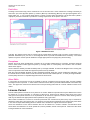
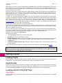
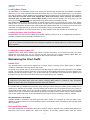
User Guide 1.3 Admiralty Vector Chart Service User Guide Version 1.3 The United Kingdom Hydrographic Office Admiralty Way, Taunton, Somerset, TA1 2DN, United Kingdom Tel: +44 (0)1823 723366 E-mail: [email protected] E-mail: [email protected] www.ukho.gov.uk UKHO 2008 All Rights Reserved The copyright in this document, which contains information of a proprietary nature, is vested in UKHO. The content of this document may not be used for purposes other than that for which it has been supplied and may not be reproduced, either wholly or in part, in any way whatsoever. ii Admiralty Vector Chart Service User Guide Version 1.3 Table of Contents Introduction........................................................................................................................1 Service Overview ...............................................................................................................1 Folios .................................................................................................................................................................1 Transit folios ................................................................................................................................................................1 Regional folios ............................................................................................................................................................2 Port folios ....................................................................................................................................................................3 Exceptions ..................................................................................................................................................................3 Other ENCs .................................................................................................................................................................3 Licence Period ..................................................................................................................................................3 Getting Started...................................................................................................................4 Loading Charts .................................................................................................................................................4 Chart Permits ....................................................................................................................................................4 Loading charts for the First Time ...................................................................................................................4 Chart Permits ..............................................................................................................................................................4 Loading Base Charts ..................................................................................................................................................5 Loading Updates from the Base disks ........................................................................................................................5 Loading the latest Update CD .....................................................................................................................................5 Maintaining the Chart Outfit ............................................................................................................................5 Update CDs ................................................................................................................................................................5 Re-Issued Base disks .................................................................................................................................................5 New Chart Permits ......................................................................................................................................................6 Schedule A ..................................................................................................................................................................6 Licence Expiry .............................................................................................................................................................6 Adding Chart Coverage ..............................................................................................................................................6 Licence Renewal .........................................................................................................................................................6 Support .......................................................................................................................................................................6 Emergency Chart Permit Generation ..........................................................................................................................6 AVCS Service Details ........................................................................................................7 About AVCS ......................................................................................................................................................7 Cell scale bands and identifiers ..................................................................................................................................7 Validation ....................................................................................................................................................................7 Data Consistency ........................................................................................................................................................7 Scale Minimum Attribute (SCAMIN) ............................................................................................................................7 Authenticity .................................................................................................................................................................7 README.TXT File .............................................................................................................................................8 PRODUCTS.TXT File.........................................................................................................................................8 Updates ..............................................................................................................................................................8 Admiralty Updating Service .............................................................................................................................8 Installing your Software ...............................................................................................................................................8 Using the Admiralty Updating Service ........................................................................................................................8 Chart Carriage Regulations ............................................................................................10 iii Admiralty Vector Chart Service User Guide Version 1.3 Flag State Acceptance of ECDIS ...................................................................................................................10 Port State Control ...........................................................................................................................................10 Using Electronic Charts in ECDIS ..................................................................................10 Training ............................................................................................................................................................10 Chart Accuracy ...............................................................................................................................................10 Source Data Quality........................................................................................................................................11 Chart Display Scale ........................................................................................................................................11 Chart Display Content ....................................................................................................................................11 Use of other Chart Formats ...........................................................................................................................11 Procedures ......................................................................................................................................................11 Use of ECDIS with Global Positioning Systems (GPS).................................................11 Accuracy and Availability ..............................................................................................................................11 GPS Reference Datum and Chart Datums ...................................................................................................12 GPS Receiver Settings ...................................................................................................................................12 Route Planning and Datums ..........................................................................................................................12 Use of ECDIS with Radar ...............................................................................................................................12 ARPA Targets..................................................................................................................................................12 Using Radar as a check on vessel position .................................................................................................12 Troubleshooting / Problem Solving ...............................................................................12 Errors ...............................................................................................................................................................13 Standard Error codes when loading AVCS ...............................................................................................................13 Decryption Failure .....................................................................................................................................................13 Conversion Errors .....................................................................................................................................................13 Copyright Information .....................................................................................................14 Feedback ..........................................................................................................................14 Annexes............................................................................................................................15 Table of Figures ..............................................................................................................................................15 Glossary ..........................................................................................................................................................15 iv Admiralty Vector Chart Service User Guide Version 1.3 Introduction Thank you for choosing the Admiralty Vector Chart Service (AVCS). This is the first official, global, all-vector chart service and is designed specifically to meet the needs of the international professional mariner, whilst providing full compliance with carriage regulations. This guide is designed to help you gain maximum benefit from using the service, and should be used in conjunction with your ECDIS User Manual. Service Overview The Admiralty Vector Chart Service is supplied by the United Kingdom Hydrographic Office (UKHO). It brings together selected Electronic Navigational Charts (ENCs) from the world’s National Hydrographic Offices, and fills the gaps in coverage with specially produced ENCs unique to AVCS. The result is a comprehensive, official, world-wide vector chart service that can be used within Electronic Chart Display and Information Systems (ECDIS). AVCS is aimed at the international, merchant shipping and will cover the top 2000 ports of the world and the routes between them. AVCS data is supplied on CD or DVD and maintained by weekly update CD or on-line through the Admiralty Updating Service (an installable application contained on the Admiralty Utilities CD). The content of the service can be viewed on the Admiralty Digital Catalogue (also on the Admiralty Utilities CD) and this application can also be used to order new data and maintain an inventory of your holdings. The service is licensed for a period of 12 months and data can be licensed for shorter periods (3, 6, 9 and 12 months) Folios In order to make it as easy as possible to select the coverage required for a vessel, AVCS is provided in geographically based folios giving world wide coverage. Each folio contains the official ENC data available within AVCS at the time of licensing. Any additional relevant ENCs released during the period of the license will be automatically included, free of charge. There are 3 types of folio available designed to maximise utility and minimise the purchase of redundant data: Transit folios The world is divided into Transit areas representing convenient and well-understood ocean regions. These contain predominantly Overview (band 1) and General (band 2) cell coverage, with Coastal (Band 3) coverage where appropriate (at selected choke points, capes, straits and convex coasts). Figure 1 AVCS Transit Folios 1 Admiralty Vector Chart Service User Guide Version 1.3 Each transit folio provides sufficient coverage for a vessel to pass safely through a region, if not engaging in local trade. Only limited Coastal band coverage is included, Approach and Harbour band coverage being available separately. The objective with Transit folios is to save operators the expense of purchasing detailed coverage for regions that they are just passing through, whilst including more coverage to negotiate the choke points. Regional folios These folios are of much smaller geographical footprint than the transit folios, of which they are usually a sub-area. Regional folios generally include all Coastal (band 3) coverage within the folio’s footprint and, where Coastal band coverage is not available (e.g. parts of Scandinavia), include Approach (band 4) cell coverage. Figure 2 AVCS Regional Folios The world’s ENC coverage at regional scales is rapidly growing. Where Regional Folios can be schemed that provide sufficient coverage for navigation in the area they will be released in AVCS. In areas where there is still insufficient coverage to populate a useful folio the individual charts are made available as ENC Units. 2 Admiralty Vector Chart Service User Guide Version 1.3 Port folios Coverage of the world’s top ports is schemed in to a set of Port Folios. Each contains the coverage necessary to enter each port, with Approach (Band 4), Harbour (Band 5) and Berthing (Band 6) cells grouped together into a single sales unit. In very complex areas where a number of ports share approaches a single Port Folio (called a ‘superport’) has been schemed to provide the coverage required for all the ports in the area. Figure 3 AVCS Port Folios Typically, the operator will be able to choose just the Transit folios required to get from their current location to a particular destination port, plus one or more Regional folios to provide more detail where necessary. The vessel operator may then choose specific detailed coverage appropriate to the port(s) they will be visiting. Exceptions Norway and some other Scandinavian countries do not provide Coastal (band 3) coverage. Therefore Regional folios in these areas include Approach (band 4) coverage which is consequently not included in the Port folios within those regions The St Lawrence Seaway has little Coastal (band 3) coverage available. Therefore the Regional folio covering this area is comprised of all Coastal and Approach (bands 4 and 5) available Both the Suez Canal/Red Sea/Gulf of Aden and Malacca Straits areas are narrow challenging waterways. Thus the Transit folios for these areas include all Overview, General and Coastal (bands 1, 2 and 3) coverage available. Consequently there are no separate Regional folios for these areas. Other ENCs In some parts of the world it will not be possible to scheme complete port and regional folios until the available coverage has been improved. In these cases customers will be able to purchase individual ENC units where they exist. This approach means that customers will not be purchasing folios that do not have sufficient content to be useful. Licence Period Licence subscriptions to AVCS are for a period of 12 months. Within this period folios may be added to the licence for periods of 3, 6 and 9 months, or until expiry of the licence. Folios may be added to the licence at any point during the licence period and there is no requirement for all licences to expire at a common date, allowing users to hold only the data that is appropriate for their operations at any given time. When folios are added to a licence for a shorter period than the overall licence period, they may be renewed or allowed to expire at the end of their term. For example a vessel whose operational area changes may allow folios in one area to expire whilst adding folios for another area, all within the original AVCS licence period. There are restrictions on the licence duration that can be offered for a number of ENCs, and therefore folios. These folios are offered for 12 month periods and, where possible, shorter month periods. Please see the AVCS Pricing Schedule for more information. 3 Admiralty Vector Chart Service User Guide Version 1.3 At the start of your licence period you will receive an Admiralty Vector Chart Service Start-Up Pack, Chart Permit files, a digital copy of the End User License Agreement and a Schedule A from your Admiralty Distributor. The Chart Permit files unlock the specific folios and charts added to the licence and the Schedule A lists the licensed folios and charts for your records. During the licence period an Update CD will be supplied weekly to enable your licensed folios to be maintained for Notices to Mariners. You will also be provided with all New Editions and replacement charts within these folios. These updates will also be available by email and over the Internet by using the Admiralty Updating Service, supplied as part of the AVCS Start-Up Pack. In addition, any new ENCs that become available in the service and within the licensed folios will be automatically provided at no additional cost. Where necessary revised Chart Permit files and a Schedule A will also be provided. Chart coverage within the service is constantly changing; a full and up-to-date list of the charts included within each area and at each level can be found in the Admiralty Digital Catalogue, downloadable from www.ukho.gov.uk. Details of charts within the folios licensed will be provided in the Schedule A document supplied with the Admiralty Vector Chart Service Start-Up Pack. HTU UTH Additional folios can be ordered via your Admiralty Distributor. AVCS charts are copy-protected. Access to the data is provided by Chart Permits which are generated for, and will only work on, the ECDIS for which they were ordered. They will be emailed to you or can be provided on floppy disk by your distributor if you require. When your Admiralty Vector Chart Service licence expires you will no longer be able to load Update CDs. Unless the licence is renewed the charts will not be updated for Notices to Mariners and will not meet SOLAS chart carriage requirements. Licence renewal can be arranged by your chosen Admiralty Distributor. Admiralty Vector Chart Service Start-Up Pack This pack should include: (This) User-guide incorporating your licence agreement Packaging (to hold your User Guide and disks) Multiple AVCS Base disks (containing all available official S-57 vector data). NB the base disks will be CDs or DVDs, depending on your requirement, and the number of Base disks may grow as coverage increases. 1 Update CD 1 Admiralty Utilities installation CD including the Admiralty Updating Service and the Admiralty Vector Chart Service Catalogue If any of these items are missing from your Start-Up pack, please contact your Admiralty Distributormailto:. HTU UTH Important: T Please ensure that you have read and understood the terms of the End User Licence Agreement before commencing use of the Admiralty Vector Chart Service. T Getting Started Loading Charts The procedure for loading AVCS data varies from ECDIS to ECDIS, but the same general principles apply and are outlined below. You should consult your ECDIS system manual for detailed instructions. Chart Permits Access to the charts on the AVCS disks is provided by Chart Permits. These are normally supplied by email and loaded into the ECDIS via floppy disk (the Permit disk), CD or USB memory stick. The Chart Permits are contained in 2 files; ENC.PMT and PERMIT.TXT. All Chart Permit files contain permits for all the licensed folios. Loading charts for the First Time Chart Permits Insert the Permit disk, or other permit media, into the ECDIS by following the procedures supplied by the ECDIS manufacturer. 4 Admiralty Vector Chart Service User Guide Version 1.3 Loading Base Charts All subscribers to the Admiralty Vector Chart Service are automatically supplied with all available AVCS Base disks, but you only need to load the Base disks that contain data you have licensed (please refer to your Schedule A for this information). Certain ECDIS require the Base disks to be loaded in the correct numerical order, therefore users who have licensed charts from multiple Base disks must always ensure that they are loaded in numerical order (i.e. Base disk 1 ahead of Base disk 2). If Base disks are loaded in the wrong order, you risk having to uninstall all pre-loaded ENC data before being able to load the base data correctly. Most ECDIS will allow you to choose whether to load all licensed charts or just those of your choice. When initially loading charts, you should be aware that the process can take some time because the ECDIS has to reformat the charts into an equipment specific format called System ENC (SENC) before use. If you require quick access to the charts then it is suggested that you load only those needed to meet your immediate requirement. Please note that between re-issues of Base disks, all newly available charts are provided via the Update CD. Loading Updates from the Base disks The Base disks may also contain updates. Some ECDIS systems require you to run an ‘Update ENC’ process as a separate procedure from the installation described above. Note: If you do not update from the Base disks first, subsequent updates from Update CDs may not load as they will be out of sequence. Loading the latest Update CD Admiralty Vector Chart Service Update CDs contain cumulative information. If you receive more than one AVCS Update CD at the same time, you only need to load the most recent one. Having loaded the Base disks and Update CDs, the ECDIS system will then display the latest chart information available. Maintaining the Chart Outfit Update CDs The Admiralty Vector Chart Service Update CD is issued weekly containing all the latest ‘Notice to Mariner’ corrections, New Editions and any New Charts issued. On receipt of the Update CDs you should load the new data using the update procedure specified in your ECDIS manual. The process should be automatic, but as required by the ECDIS specifications you will be asked by the ECDIS to accept the updates. Again, if you receive more than one Admiralty Vector Chart Service Update CD at the same time, you only need to use the most recent one because they are cumulative. Note: If replacement AVCS Base disks have been issued, containing New Editions or updates of cells, subsequent updates for those cells cannot be applied until these have been installed. It is possible that your ECDIS will occasionally report warnings or errors during the update process. Whilst it is not possible to be definitive in this matter, users are advised that a warning can be accepted as being very unlikely to corrupt data already loaded, but an error should be treated more seriously and the chart should only be used with caution since it may not reflect the latest Notices to Mariners information. Users should notify the UKHO Helpdesk (see contact details inside front cover) if their ECDIS system reports errors on loading of charts or updates. NB: Stored Routes and Updates Updates applied to the ECDIS may affect previously stored routes. It is important to check the effect of any updates on a stored route prior to its use. ECDIS is able to automatically check route safety where licensed AVCS data is available. Re-Issued Base disks The UKHO periodically re-issue Base disks (CD or DVD) in order to integrate newly available Base data that is temporarily held on the Update CD. When this happens, all currently available Base disks are issued 5 Admiralty Vector Chart Service User Guide Version 1.3 simultaneously. All new editions and updates are also included on the replacement AVCS Base disks at this time; therefore no accompanying Update CD will be issued in a week when this occurs. On receipt of re-issued AVCS Base disks you only need to run an update routine; there is no need to reload all charts. New Chart Permits You will automatically be issued with necessary Chart Permits to provide access to newly available or replaced ENCs within your licensed AVCS folios. Please ensure that you load new Chart Permits when you receive them to ensure your ECDIS has the capability to use the charts from the latest CDs. Schedule A The Schedule A is issued with each order and lists the content of all the folios that have been purchased in that order. Amendments to this will be provided with the weekly Update CD where this is necessary. The amendment will list details of cancelled and replaced ENCs and any new ENCs added to your licensed AVCS folios. Licence Expiry Once the subscription period for the licence or a folio has ended, the ECDIS system will prevent the loading of further updates until the licence or folio is renewed. You will be able to continue to view folios and updates that were loaded prior to licence expiry. The expiry date is shown on the Schedule A supplied at the time of purchase and on the Permit disk. Note: AVCS must be kept up-to-date to meet IMO SOLAS requirements. An ECDIS using charts beyond the expiry date of the licence will not meet chart carriage requirements. Adding Chart Coverage Additional AVCS folios may be purchased during the subscription period through your chosen Admiralty Distributor who will supply new Chart Permits to ‘unlock’ the newly added folios. These permit files are cumulative so as well as unlocking the new coverage they will also hold the permits necessary to unlock all your existing coverage. Licence Renewal Approximately four weeks before licence expiry you should receive a renewal reminder from your Admiralty Distributor. To ensure continuity of service, please confirm requests for renewal at least 24 hours in advance of the expiry date. Support Support for all of your Admiralty products is available from your Admiralty Distributor. Support from the UKHO is provided through the UKHO Helpdesk. All enquiries are logged on receipt, allocated a unique reference number and monitored through to closure. The UKHO Helpdesk may be contacted with any question relating to any Admiralty product. The UKHO Helpdesk can be contacted by emailing [email protected] or calling +44 (0) 1823 723366. Standard product support is available during UK working hours (09:00 – 17:00). Emergency Chart Permit Generation Where a vessel is diverted for commercial reasons an order can be raised through your supplier. Your supplier will receive the permits within 10 minutes of placing the order on the Admiralty Product Ordering System (APOS) and these can then be forwarded on to you by arrangement with your supplier. In certain circumstances it may be necessary for a vessel to get access to an AVCS chart at very short notice, for instance if she has to divert her route due to a medical or safety emergency. In these emergency circumstances, individual AVCS Chart Permits can be obtained from the UKHO 24 hours a day, 365 days a year. These Chart Permits can be transmitted direct to the vessel by email wherever possible, by fax, or simply by reading the characters out over the telephone or radio. Each Chart Permit consists of 64 characters. To obtain an AVCS emergency Chart Permit please contact the UKHO Helpdesk during UK normal office hours. Outside of office hours please contact the UKHO Watch Keeper by emailing [email protected], 6 Admiralty Vector Chart Service User Guide Version 1.3 phoning +44 (0) 1823 353448 or faxing +44 (0) 1823 322352. Please quote your vessel name, the User Permit Number of your ECDIS system and the cell number(s) required. AVCS Service Details About AVCS Cell scale bands and identifiers AVCS is an ENC-based service sold in convenient and cost-effective folios. Each transit, regional and port folio includes selected ENC cells and units, and is displayed in exactly the same way. The digitised vector data in an ENC records all the relevant chart features such as coastline, buoys, lights, etc. These features, including their associated attributes and attribute values are held in a database that allows them to be selectively displayed and queried. This provides the potential to manipulate the chart image displayed on screen. Each ENC has an 8-character identifier. The first two characters indicate the producer nation (e.g. GB for a UK produced cell, NL for a Netherlands cell, etc), the third character indicates the ‘usage band’ into which the cell falls and the last 5 characters are used as the unique identifier for that ENC. The usage band designator indicates the intended navigational purpose of the ENC and will take one of the following values: 1 Overview 2 General 3 Coastal 4 Approach 5 Harbour 6 Berthing Therefore, GB500005 is a UK produced ENC cell in the harbour usage band. Validation Comprehensive validation checks are run on all ENCs before they are released in the Admiralty Vector Chart Service to ensure consistency with IHO standards. This minimises the chances of errors or warnings being displayed on the ECDIS during loading caused by minor interpretational differences in the standard between ENC producers and ECDIS manufacturers. If you do experience any problems with data quality, you should contact your Admiralty Distributor or the UKHO Helpdesk so that the situation can be promptly investigated. Data Consistency It is possible that the mariner may experience some inconsistency in the chart data display (such as a mismatch of contours etc) at the boundary of two different producers (effectively where charting responsibility for this data crosses from one nation to the next). This problem has been recognised by the IHO and guidance has been provided to ENC producers to resolve the issue. Scale Minimum Attribute (SCAMIN) Each object in an ENC is given a SCAMIN value. The SCAMIN of an object determines the display scale below which the object must no longer be displayed by an ECDIS and can be a valuable tool in reducing the clutter on the screen. There is currently no international agreement on the SCAMIN values to be employed and in some cases, different ENC producers may have applied differing SCAMIN values to similar objects. The mariner should exercise caution when operating in reduced display modes. Authenticity It is important to ensure that the charts loaded into your ECDIS have come from an authorised source, especially if you are using ENCs as your primary source of navigational information. All ECDIS capable of using the IHO S-63 Data Protection Scheme automatically verify this by authenticating the digital certificate stored on the system against the signature file associated with each cell supplied via the Admiralty Vector Chart Service. 7 Admiralty Vector Chart Service User Guide Version 1.3 README.TXT File The AVCS disks contain a ‘Readme.txt’ file (located in the ‘ENC_ROOT’ directory). This provides information from each ENC producer on the use of their charts in the service. It also contains important safety related information and must be read before use of the data contained in this service. PRODUCTS.TXT File The ‘Products.txt’ file is stored in the INFO folder in ENC_ROOT directory of each disk. It contains information relating to the status of all cells in the Admiralty Vector Chart Service (edition number, update number, etc). ECDIS use this file to manage the import of new AVCS data by comparing the status of each cell on the disk with information already held in the SENC prior to import. It is this mechanism that ensures that unnecessary ENC data is not imported and reformatted to the ECDIS Updates The Admiralty Vector Chart Service supplies the latest updates issued by the chart producer. These updates may or may not be synchronised with Notices to Mariners produced for their national paper chart series. UK produced ENCs are maintained for Notices to Mariners in line with the Admiralty paper chart series. Admiralty Updating Service Updates for AVCS are also available via the Admiralty Updating Service. This complementary service has been created to provide the latest available updates via email or web service. For detailed information about the operation of the Admiralty Updating Service, please refer to the full User Guides on the installation CD. Notice: A Weekly Update CD will continue to be sent to you via your Admiralty Distributor in accordance with Admiralty Notices to Mariners (NMs), for the period of your licence. It is recommended that the Online Service is used in conjunction with your most recent, weekly Update CD and that after downloading remote updates that you immediately update your ECDIS/ECS display system. Important: T We strongly recommend that you keep separate permanent written records of all information that you choose to download for reference purposes, in line with SOLAS Regulation Chapter V 2002. T Installing your Software To install your Admiralty Updating Service Software please follow the steps below: 1. Close all programs/applications. 2. Insert your Admiralty Updating Service CD into the CD-ROM drive of your computer. 3. If the installation program does not start automatically, locate and run (double click on) the file named setup.exe within the ‘client’ folder using Windows Explorer 4. Select the Updating Service that you wish to install. 5. Follow the on-screen instructions. Using the Admiralty Updating Service To launch the Admiralty Updating Service, double click on the desktop icon or select Start – Programs – Admiralty Updating Service – Admiralty Updating Service. Before you start you will need: Your latest AVCS Update CD (this should be the same one that was used to update your ECDIS and not a previously compiled Online Update Service CD which contains downloaded information). Your AVCS Chart Permit files. A writeable CD or other transfer medium that is supported by your ECDIS (e.g. USB memory stick). 8 Admiralty Vector Chart Service User Guide Version 1.3 Request Window List Known Window Cells Request Window Monitor Figure 4 Online Updating Use the toolbar buttons starting from the top left side of the screen to set the application up for initial use. Buttons are disabled until the application has been given sufficient information for them to operate correctly. The initial setup tasks are: Set AVCS Update CD Date Update AVCS Catalogue Load Permit File Note: During initial setup the ‘Read the email Inbox’ button will remain disabled. If the initial AVCS catalogue update is requested by email it will be necessary to double-click on the returned attachment file to get it to load. Use the Request buttons (below) or drag-and-drop to populate the Request List Window and then send the request to the UKHO. Note: It is also possible to use a manually created list of cell names. The cell names should be stored in a simple text file – one cell name per line. The text file should then be saved in the folder “C:\Documents and Settings\All Users\Application Data\CherSoft\ENC Online Updating Service\Requests”. The file can then be accessed from the drop-down in the Request List window. Select the ‘Create Exchange Set’ button to generate the AVCS Update CD structure. Now transfer the AVCS Update CD to your ECDIS by burning it to CD (set the CD Volume Name to “V01X01”) or on another media such as USB memory stick. Important: Once the CD has been written, it should be used to update your ECDIS/ENC display system. This will ensure that your EOUS application and your ECDIS display system are synchronised with the latest updates. 9 Admiralty Vector Chart Service User Guide Version 1.3 Note: When a new UKHO published AVCS Update CD is received this should be installed in your ECDIS system to bring all your charts up-to-date (not just those requested). The Update CD should then be installed within the AUS system to reset its internal ‘Starting from’ date. Chart Carriage Regulations Flag State Acceptance of ECDIS SOLAS regulations were amended in 2000 to specifically allow the use of ECDIS to meet carriage requirement in place of paper charts. “All ships irrespective of size shall have nautical charts and nautical publications to plan and display the ship’s route for the intended voyage and to plot and monitor positions throughout the voyage; an electronic chart display and information system (ECDIS) may be accepted as meeting the chart carriage requirements of this sub paragraph.” IMO SOLAS Chapter V, Regulation 19, 2.1.4 As yet, not all nations have adopted the amended regulations into their own national legislation nor have they made clear their acceptance of ECDIS. For this reason ship owners and mariners should consult their Flag State authority for guidance on meeting SOLAS obligations with ECDIS To meet chart carriage requirements the ECDIS must be type approved, have a suitable back up that can take over in event of failure of the primary system and be using ENCs. As AVCS is an ENC-based service, when displayed in a type-approved Electronic Chart Display and Information System (ECDIS) with an appropriate backup, it may be used for primary navigation where flag state approval exists (SOLAS V reg 19 2.1.4) and replace the paper chart. Port State Control It is normal for any Port State inspection to accept the vessel’s Flag State implementation of SOLAS regulations; the vessel should carry documentation to show compliance to their Flag State requirements. Using Electronic Charts in ECDIS The ECDIS user manual will outline many useful system features and functions that can be used to assist you in navigating your vessel. However, using electronic charts, especially for the first time, presents the mariner with many new and important issues that need to be taken into consideration if the highest levels of vessel safety are to be maintained. In the following section of this guide we have outlined some of these issues and we urge you to take these into consideration when using electronic charts provided in the Admiralty Vector Chart Service. Training It is recommended that users undertake both generic training in the use of electronic chart systems and charts as well as type specific ECDIS training for the system to be used. Training in the use of the advanced voyage planning and monitoring facilities that these systems provide will ensure you can take maximum advantage of the benefits of electronic charts Chart Accuracy The ECDIS is a powerful navigational tool, however its usefulness is limited by the quality of the chart data that it is using. Most ENCs are derived from paper charts; therefore, the chart displayed on the ECDIS will generally be no better than that of the equivalent paper chart, both in terms of positional accuracy and hydrographic information content. It should be remembered that the positional accuracy of features on charts based on old surveys may not be as good as the positions that can be obtained from GPS; this fact should be taken into account when determining suitable clearance distances from charted features. 10 Admiralty Vector Chart Service User Guide Version 1.3 Source Data Quality Source data accuracy is shown on the face of an ENC using symbols. There are 5 ‘Zone of Confidence’ categories, each depicted by ‘stars’ within a triangle outline (6 stars being the best). The confidence rating refers to the level of confidence that the producer has in the accuracy of the source data from which the chart is compiled. Due to the difficulty of allocating a zone of confidence category, especially where derived from a paper chart, a 6th ‘un-assessed’ category (a ‘u’ within an ovoid outline) is commonly used. The quality of underlying data can be determined from examination of the title notes and cautions and especially the Source Data Diagram that gives a graphical indication of the survey information making up the chart. Chart Display Scale Just like paper charts, ENCs are compiled at scales suited to their intended use, taking account of all available source material. For this reason they should only be used for navigation at, or near, their compilation scale. The majority of ECDIS systems incorporate a zoom function that allows the user to enlarge or reduce the scale of the displayed image. This function can be useful, for instance, for enlarging complex areas for the purposes of clarity, however, navigating using a scale significantly different from the compilation scale is potentially dangerous as it can give a false impression of distances. For this reason, ECDIS systems give a visual warning when charts are ’over-zoomed’ this is a graphical warning (vertical bars on the display). Some ECDIS also display a prominent warning message somewhere in the viewer stating that the cell is being viewed at either “OVERSCALE” or “UNDERSCALE”. Where a greater or lesser level of chart detail is required, a larger or smaller scale should be selected for use. Chart Display Content When navigating using AVCS, users can select the amount of detail that is displayed, thereby reducing the amount of visible charted detail on screen. There are three common display modes; ‘base’, ‘standard’ and ‘all’. Users cannot deselect objects from the ’base’ display as this contains the minimum information permitted for safe navigation. ECDIS generates warnings based on the full chart database not just from the details displayed Use of other Chart Formats As well as being able to use official S-57 data, many ECDIS systems provide the facility to use other types of electronic chart. Where other chart data is used in the ECDIS in combination with Admiralty Vector Chart Service charts, users should exercise caution as this other data may not be produced to the same standard or updated to the same date. Procedures ECDIS linked to GPS, radar and other navigation devices is a powerful aid to navigation, providing assistance for quick and sound decision making; however it should not be used in isolation to make navigational decisions. Visual observation of the world beyond the bridge windows remains a vital for safe navigation. By providing continuous display of own vessel position and radar targets ECDIS can provide additional opportunity for the watch keeper to keep lookout It remains essential to monitor the correct operation of all electronic equipment. Traditional relative navigation techniques (e.g. visual fixing or radar range and bearing) should be employed to confirm that correct vessel position is shown on the ECDIS. It is important to ensure that all of the latest updates are loaded onto the system, and whenever possible, it is preferable to load available updates before you commence your voyage. Please note that loading and updating can take some time. Use of ECDIS with Global Positioning Systems (GPS) Accuracy and Availability GPS is capable of horizontal positioning accurate to approximately ±33m for 95% of the time. DGPS (a refinement of GPS) allows a typical accuracy of ±5–10m. It should be remembered that many of the surveys on which both paper and modern electronic charts are based were carried out long before GPS was available. Thus the accuracy of charted detail will in many cases not be to the same order of accuracy as is provided by GPS. This fact should 11 Admiralty Vector Chart Service User Guide Version 1.3 be considered in determining which scale chart to use, and what are suitable tolerances when making navigational decisions. The mariner is encouraged to employ alternative means to monitor GPS positional accuracy and to have an independent means of position fixing on the ECDIS so as to ensure continued safe navigation If GPS is subject to accuracy or availability problems. GPS Reference Datum and Chart Datums GPS is based on the World Geodetic System 1984 (WGS84) datum. However positions on many original surveys have been established by taking astronomical observations. Historically, the survey of each geographical area might have been based on different established datum, and accordingly charts worldwide have been drawn on a variety of datums. The relationship between the positions of features surveyed on different datums is still not necessarily known. This means that any point on the Earth's surface may have a different latitude and longitude depending on the local datum to which the position is referred. For this reason GPS positions for charted objects can be very different from their local datum positions; this difference is known as the datum shift. Further information on GPS and other satellite navigation systems can be found in the Admiralty List of Radio Signals Volume 2 (NP282) GPS Receiver Settings Older GPS receivers are not able to provide Datum information via the NMEA interface to ECDIS and some earlier ECDIS systems may not recognize this information if it is provided. It is therefore strongly recommended that, when used with ECDIS, GPS receivers are set to output positions in WGS84 Datum. If the GPS is set to provide positions in other than WGS84 datum then it is possible that the ECDIS may misinterpret the data received and positions may be incorrectly displayed. Route Planning and Datums Positions stored for routes and / or overlay information may be recorded as local datum positions. If the route is later plotted on a chart having a different datum, the route may not plot correctly. Care should be taken when displaying such data on a chart other than the one on which it was created or where routes are transferred between systems. Use of ECDIS with Radar Many ECDIS systems have the capability to overlay both raw radar video and / or ARPA (Automated Radar Plotting Aid) targets onto the display. Where the full radar image is used it is possible that charted information may be obscured. Superimposition of the full radar image may cause unacceptable cluttering of detail on some charts. ARPA Targets The superimposition of ARPA targets on the ECDIS display allows the rapid assessment of the possible actions of targets with respect to shoal water, traffic separation schemes etc. The Radar should remain the primary tool for collision avoidance; ECDIS should only act as an aid to possible target intentions. Using Radar as a check on vessel position A convenient means to monitor correct referencing of vessel position to chart is to choose a charted radar conspicuous feature and to select this as an ARPA target which is displayed on the chart. If the target remains located over the charted position of the feature this is a good indication that systems are functioning as expected. Where the ECDIS allows the display of raw video over the chart a comparison of charted coastline with the radar image can be used in the same way; however care should be exercised as the apparent RADAR coastline can vary according to the nature of coastline and height of tide. Troubleshooting / Problem Solving Should you experience problems when loading data into your ECDIS, you may find it difficult to determine exactly which element of your system is at fault. Where one of the standard error messages shown below is encountered then you should report this to your Admiralty Distributor or contact the UKHO Helpdesk. If the fault appears to be 12 Admiralty Vector Chart Service User Guide Version 1.3 hardware related (eg failure of a floppy disk or CD drive) then we advise you to contact your ECDIS system supplier. When reporting a chart related problem it is useful if you can provide the following details: Admiralty Vector Chart Service licence number ECDIS system being used (especially if you have more than one system on board) The date (or week number) of the latest disks held on the vessel The issue date of the latest Chart Permits held. If the problem appears to be related to the permits it is best to send a copy of the latest Chart Permits held by email if this is possible. Any error messages displayed on the ECDIS Whilst the wording of displayed error messages may vary from ECDIS to ECDIS the error codes are constant. Errors Standard Error codes when loading AVCS Error messages likely to be displayed in an ECDIS SSE 03 Certificate is invalid (Authentication failure) SSE 04 Format of Certificate is incorrect (Authentication failure) SSE 05 SA Digital Certificate file is not available (Authentication failure) SSE 06 SA Digital Certificate is invalid (Authentication failure) SSE 07 Certificate file is not available (Authentication failure) SSE 08 Format of Private Key is incorrect (Authentication failure) SSE 09 Signature is invalid (Authentication failure) SSE 10 Files are different (check after decryption) SSE 11 Cell Permit file not found (Decryption failure) SSE 12 Cell Permit format is incorrect (Decryption failure) SSE 13 Cell Permit is invalid (checksum [CRC] is incorrect / decryption failure) SSE 14 Incorrect system date SSE 15 Subscription licence has expired SSE 16 ENC CRC value is incorrect Codes 03 to 09 relate to the ECDIS check of the authenticity of the disks being loaded. Codes 11 to 13 relate to the permits supplied Codes 14 and 15 relate to checks on licence validity Codes 10 and 16 relate to checks carried out on the consistency of the ENC data. Decryption Failure This is normally due to the Chart Permit available not being compatible with the edition number of the chart being loaded. Check that the latest Chart Permit files have been loaded. If the problem is not resolved by reloading the Chart Permits then contact the UKHO Helpdesk. Please inform them of the latest Base / Update being used, any error messages displayed and forward a copy of the PERMIT.TXT file from the permit disk if using email. Conversion Errors When charts are loaded into an ECDIS they are converted from the standard format they are supplied in (S-57) to the systems specific format of the ECDIS being used (the System ENC – SENC). Conversion errors are reported when the ECDIS is unable to interpret the detailed information within the chart during the conversion process. Data being supplied within the Admiralty Vector Chart Service has been validated to very high standards and the number of errors being reported should be low. However the ENC data standard (S-57) is extremely complex and 13 Admiralty Vector Chart Service User Guide Version 1.3 in some circumstances it is possible for the ECDIS supplier and ENC producer to have used subtly different interpretations of the standard and this can result in a warning message being displayed on ECDIS. When loading charts the ECDIS could report three error conditions: 1. The ECDIS is unable to load the chart or Update at all. This is very uncommon; please report this problem to the UKHO Helpdesk. 2. The ECDIS loads the chart or Update and reports an error. This is not common; users should use the chart with caution and report the error to the UKHO Helpdesk. 3. The ECDIS loads the chart or Update and reports a warning. This is quite common on some ECDIS systems and reflects minor interpretational differences of the S-57 standard. We are not aware of any evidence that the correct operation of the chart in the ECDIS is affected in these cases. Copyright Information The Admiralty Vector Chart Service is derived from Crown Copyright information and information supplied by other organisations. Except as provided in the User Licence, no part of the Admiralty Vector Chart Service may be sold, stored in a retrieval system or transmitted in any form or by any means electronic, mechanical, photocopying, recording or otherwise without the express permission of the United Kingdom Hydrographic Office, Admiralty Way, Taunton, Somerset, United Kingdom, TA1 2DN. All ENCs included in the Admiralty Vector Chart Service are issued by or on the authority of governmentauthorised Hydrographic Offices. Each country is responsible for producing ENCs of its own waters, which must be updated systematically with all safety-critical information and be fully compliant with the International Hydrographic Organisation’s (IHO’s) S-57 ENC product specification. Therefore each ENC producing nation carries the liability for its own data as supplied in this service. Feedback The UKHO welcomes customer comments, if you would like to provide any feedback, please forward any comments via your Admiralty Distributor or directly to the UKHO Helpdesk. 14 Admiralty Vector Chart Service User Guide Version 1.3 Annexes Table of Figures Figure 1 AVCS Transit Folios .................................................................................................................................... 1 Figure 2 AVCS Regional Folios ................................................................................................................................. 2 Figure 3 AVCS Port Folios ......................................................................................................................................... 3 Figure 4 Online Updating ........................................................................................................................................... 9 Glossary ARPA Automated Radar Plotting Aid BA British Admiralty ECDIS Electronic Chart Display and Information System ECS Electronic Chart System ENC Electronic Navigational Charts GPS / DGPS Global Positioning System / Differential Global Positioning System IC-ENC International Centre for ENCs IHO International Hydrographic Organization IMO International Maritime Organization RENC Regional ENC Co-ordinating Centre SCAMIN Scale Minimum attribute used to automatically declutter the ECDIS screen when zooming out Schedule A A listing of all chart holdings purchased through a single transaction(weekly updates will only show changes to those holdings) SOLAS IMO Safety of Life at Sea Convention UKHO United Kingdom Hydrographic Office WGS84 World Geodetic System, 1984 datum 15