1
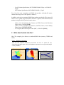
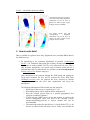
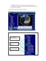
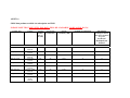
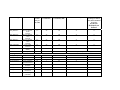
How to get SMOS data – If you are interested to use data of the Soil Moisture and Ocean Salinity mission for your scientific research you might find the following information helpful to guide you through the registration and ordering process. 1 Which products are available? The following SMOS data products will be available: - - - - - Level 1A product: calibrated visibilities between receivers prior to applying image reconstruction. Level 1B product: output of the image reconstruction of the observations and comprising the Fourier component of the brightness temperature in the antenna polarisation reference frame. Level 1C product: multi-angular brightness temperatures at the top of the atmosphere, geolocated in an equal-area grid system. Two different Level 1C products are generated according to the surface type: one containing only sea and the other only containing land pixels. Two sets of information are available: pixel-wise and snapshot-wise. For each Level 1C product there is also a browse product containing brightness temperatures for an incidence angle of 42.5°. Level 2 soil moisture product: containing not only the soil moisture retrieved, but also a series of ancillary data derived from the processing (nadir optical thickness, surface temperature, roughness parameter, dielectric constant and brightness temperature retrieved at top of atmosphere and on the surface) with the corresponding uncertainties. Level 2 ocean salinity product: containing three different ocean salinity values derived from retrieval algorithms using different assumptions for the surface roughness correction and the brightness temperature retrieved at the top of atmosphere and on the sea surface (with the corresponding uncertainties). Near-real time product: similar to the Level 1C product but adjusted to requirements of operational meteorological agencies such as ECMWF and MétéoFrance, available 3 hours from sensing. It will contain brightness temperatures at the top of the atmosphere on an ISEA grid with reduced spatial resolution. In addition a number of calibration and auxiliary data files will be made available. The various data products are described in detail in the product specifications, which can be found in the document library: - Level 0 Product Specification, SO-TN-IDR-GS-0003 L0 Spec v3.4 2009-0429.pdf Level 1 Product Specification, SO-TN-IDR-GS-0005 L1 Spec v5.9 2009-0504.pdf - Level 2 Product Specification, SO-TN-IDR-GS-0006 L2 Spec v4.2 2009-0504.pdf NRT Product Specification, SO-ID-DMS-GS-0002 v2_2.pdf For a list of the most commonly used SMOS data products, including file names, content and average size of files please see Annex A. In addition to the above mentioned SMOS data products provided by ESA, there will also be level 3 (global, single-instrument) and level 4 (global, multi-instrument) data products, being provided by national expert centres: - Centre Aval de Traitement des Donnees (CATDS, France) Soil Moisture Expert Centre, CESBIO [LINK] Centre Aval de Traitement des Donnees (CATDS, France) Ocean Salinity Expert Centre, IFREMER [LINK] CP-34 (Spain) Barcelona Expert Centre (BEC) - ICM-UPC [LINK] 2 What does the data look like? Note: The examples given below are simulated SMOS data (courtesy CESBIO and ACRI). Level 1 – Brightness temperatures From left: One snapshot/ simultaneous observation for Level 1C product (H pol); fixed/selected incidence angle ~40ºV pol; Brightness temperature for one grid point (images courtesy CESBIO). TB values for one grid point 290 270 TB (K) 250 230 210 190 170 150 15 20 25 30 35 Inci dence angl e 40 45 50 Level 2 – soil moisture and ocean salinity Soil moisture retrieved over Africa (left) and corresponding brightness temperature (V pol) at 42.5º at surface for same overpass (right) (images courtesy CESBIO). Sea surface salinity (left) and corresponding brightness temperature (V pol) at 42.5º at surface for same overpass (right) (images courtesy ACRI). 3 How to order data? Data is available to registered users only. Registered users can obtain SMOS data in two different ways: 1. By subscribing to the systematic distribution of products (“subscription service” = for continuous and regular flow of data): all data products required by the user are made available via FTP, to be collected by the user. This is only for future acquisitions, over specific areas of interest and/or only for a particular time span. To subscribe the user will have to submit a full proposal on http://eopi.esa.int link to category-1. After submission of the proposal through the EOPI portal and signing the Terms and Conditions, the user will be contacted by ESA’s Help Desk ([email protected]) once the proposal has been accepted by mission management to collect the user’s data requirements and set-up the subscription. The following information will be needed (see also Annex B): o Which type of data access is requested (see 3.2.1)? o What data products will be required and for which period? o Does the research project focus on a specific geographical area (polygon coordinates required)? o If near-real-time (NRT) access to the data product is required, the mission management office will need to be contacted (e-mail: [email protected]) to discuss whether this can be accommodated. o The nominal procedure for data delivery is via pull from a FTP, i.e. for the user to collect his/her data from a server. If this is not feasible for the user the EO Help Desk needs to be contacted ([email protected]) to discuss alternatives1. o Will the user like to receive re-processed data once the baseline for the processing of the data products changes? 2. By searching the SMOS data product catalogue EOLI and submitting an order for selected archived products (limited to 20 products per order). The catalogue also provides access (immediate download, but only one product at the time) to the most recent data through the rolling on-line archive. For this type of data access the user will have to submit a registration form including a short description of the project on http://eopi.esa.int link to registration. No approval of the project by mission management is necessary, access will be provided within 2 working days. 3. Bulk data retrieval from the SMOS archive: the user will have to submit a full proposal following the same procedure as outlined under 1. Mission management will then assess how to distribute the data before accepting the request. 4. Searching and ordering SMOS products using the catalogue You can search SMOS data products using the EOLi application which can be installed on all major platforms from http://earth.esa.int/EOLi/EOLi.html. EOLi (Earth Observation Link) is ESA’s client for Earth Observation Catalogue and Ordering Services. Using EOLi, you can browse the metadata and preview images of SMOS data products. Scientific users with a registered account can order or download products of various processing levels. Starting from the EOLi main interface (image below) you reach the SMOS data collection by navigating the collection tree on the left panel. Select the collections of interest, specify a date range (bottom left panel), optionally draw an area of interest on the map (using the “set area” mode) and click the “Search Catalogue” button (bottom left). Please refer to the EOLi quick guide for more detailed information: http://eoli.esa.int/EOLIResources/Other/EOLIv6QuickGuide.pdf. A more complete user manual is also available on http://eoli.esa.int/EOLIResources/Manual/html/ frame.html. The SMOS data products available on EOli are a subset of the data products being available via subscription and are split into (see Figure below): 1 Alternative data delivery methods could be: media (CD-ROM or DVD) or pushing data products to your FTP server (your FTP server will need to be accessible 100% of the time, properly sized, and accessible through a fast enough connection). Refer to the table provided in Annex A for indication on the size and throughput for each data product types and let us know frequency in which you would like to receive data. - A catalogue of “historical” data, for the present and past baseline, and A “rolling on-line” archive, for the present baseline, data remain in here for at least a week after acquisition. ` For a list of the respective data products see Annex A. EOLi catalogue SMOS data products Classic ordering via EOLI shopcart through MMOHS Direct download via EOLI download manager (current baseline only) You can either - order the data via the EOLi shopcart through the Multi Mission Order Handling Service (MMOHS), for data in the catalogue of the “historical” data, or - download the data directly via the EOLi download manager (right-clicking on an item in the table below the map), for data in the “rolling on-line archive” and only for the current baselineError! Bookmark not defined.. The current baseline refers to the present version of the processors being used to process the SMOS data products. Once it is decided to use a new version of processors due to improvements in the algorithms the current baseline will migrate to the previous baseline. Both will be available on EOLi for a subset of data products. The difference between the baselines will be communicated via the webpage. 5. How are the data distributed? For the subscription service, the default distribution of SMOS data products is done through a FTP server (either from ESAC at Villafranca or from the LTA in Kiruna) with the user to collect the data as and when convenient. A notification email with access details will be sent to you. Alternatively, if you are not able to use this data distribution approach, data can be pushed to you via FTP or you might receive the data via mail on CD-ROM or DVD media. Allow 1 or 2 days delay whenever electronic transfer is used (i.e. FTP), and a few days, depending on your location, for land shipment. 6. What tools are available to view SMOS data products? A number of tools are available to view SMOS data products, ranging from data simulators, prototype processors to software to visualise certain aspects of the data. For a description please see SMOS tools.pdf. The tools can be downloading from: - SMOS End-to-End Simulator (SEPS-GS) http://www.smos.com.pt SMOS L1 Prototype Processor & visualisation tool http://www.smos.com.pt SMOS L2 Soil Moisture Prototype Processor ftp://www.array.ca/20090120_L2SM_CoreV4/ SMOS L2 Sea Surface Salinity Prototype Processor http://www.smos.esa.int/ Tool: http://www.enviport.org:8080/argans/smos/builds/op_03_04/ (smos, sss2008) User manual http://www.enviport.org:8080/argans/smos/docs/deliverables/delivered/PPSUM - (smos, sss2008) SMOS Data viewer ftp://193.146.123.163/smos/software/SMOSView/ - SMOS Tool Box (BEAM) http://www.brockmann-consult.de/beam-wiki/display/SBOX/SMOS+Toolbox+for+BEAM - SMOS Global Mapping Tool ftp://193.146.123.163/smos/software/GMT/ SMOS Comparison Tool ftp://193.146.123.163/smos/software/SCOT/ SMOS XML R/WAPI ftp://193.146.123.163/smos/software/XML_RW_API/ ANNEX A SMOS data products available via subscription and EOLi PLEASE NOTE THAT ONLY FULL POL DATA WILL BE AVAILABLE, NO DUAL POL DATA! Product Type Context Average Product Size per file (MB) Average # of Products/Day Average Volume/Day (MB) Available via subscription EOli ordering (ordering for historic data, direct download for recent data)Error! Bookmark not defined. Science data MIR_SC_D1A MIR_SC_F1A MIR_SC_D1B MIR_SC_F1B MIR_SCSD1C MIR_SCSF1C MIR_SCLD1C MIR_SCLF1C MIR_BWSD1C Level 1A Dual Pol Level 1A Full Pol Level 1B Dual Pol Level 1B Full Pol Level 1C Ocean Dull Pol Level 1C Ocean Full Pol Level 1C Land Dual Pol Level 1C Land Full Pol Browse Product Ocean Dual Pol 115 28 3170 X 230 28 6340 X 61 28 1705 X X 122 28 3410 X X 284 28 7960 X X 470 28 13100 X X 170 28 4780 X X 290 28 8190 X X 5.5 28 155 X X Product Type Context Average Product Size per file (MB) Average # of Products/Day Average Volume/Day (MB) Available via subscription EOli ordering (ordering for historic data, direct download for recent data)Error! Bookmark not defined. MIR_BWSF1C Browse Product Ocean Full Pol MIR_BWLD1C Browse Product Land Dual Pol MIR_BWLF1C Browse Product Land Full Pol MIR_SMUDP2 Level 2 Soil Moisture MIR_OSUDP2 Level 2 Ocean Salinity BUFR NRT product Varying Auxiliary Data AUX_VTEC_P Predicted VTEC AUX_ECMWF ECMWF data AUX_DFFLAI MODIS LAI AUX_DGGTLV Low vegetation optical thickness AUX_DGGTFO Forest optical thickness AUX_DGGROU Land roughness AUX_DGGRFI Radio frequency interference AUX_DGGFLO Flood Flag probability 5.5 28 155 X X 3.5 28 100 X X 3.5 28 100 X X 15 28 415 X X 23 28 640 X X 180 ~20 3660 <1 50 222 48 1 29 0.125 1 1 1450 28 48 X X X X 48 0.03 2 X 48 63 0.03 0.03 2 2 X X 34 0.03 2 X Available on special request to [email protected] X Product Type Context Average Product Size per file (MB) Average # of Products/Day Average Volume/Day (MB) Available via subscription EOli ordering (ordering for historic data, direct download for recent data)Error! Bookmark not defined. AUX_VTEC_C AUX_VTEC_R Consolidated VTEC Analysis Rapid VTEC <1 1 1 X <1 1 1 X