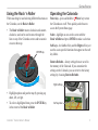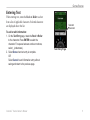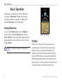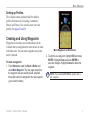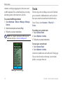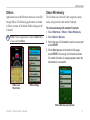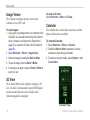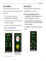
1
Owner’s Manual
Colorado Series
™
all-terrain GPS navigator
© 2008 Garmin Ltd. or its subsidiaries
Garmin International, Inc.
1200 East 151st Street,
Olathe, Kansas 66062, USA
Tel. (913) 397.8200 or (800) 800.1020
Fax (913) 397.8282
Garmin (Europe) Ltd.
Liberty House
Hounsdown Business Park,
Southampton, Hampshire, SO40 9RB UK
Tel. +44 (0) 870.8501241 (outside the UK)
0808 2380000 (within the UK)
Fax +44 (0) 870.8501251
Garmin Corporation
No. 68, Jangshu 2nd Road,
Shijr, Taipei County, Taiwan
Tel. 886/2.2642.9199
Fax 886/2.2642.9099
All rights reserved. Except as expressly provided herein, no part of this manual may be reproduced, copied, transmitted, disseminated,
downloaded or stored in any storage medium, for any purpose without the express prior written consent of Garmin. Garmin hereby grants
permission to download a single copy of this manual onto a hard drive or other electronic storage medium to be viewed and to print one
copy of this manual or of any revision hereto, provided that such electronic or printed copy of this manual must contain the complete text
of this copyright notice and provided further that any unauthorized commercial distribution of this manual or any revision hereto is strictly
prohibited.
Information in this document is subject to change without notice. Garmin reserves the right to change or improve its products and to make
changes in the content without obligation to notify any person or organization of such changes or improvements. Visit the Garmin Web site
(www.garmin.com) for current updates and supplemental information concerning the use and operation of this and other Garmin products.
Garmin®, MapSource®, BlueChart®, and Dynastream® are trademarks of Garmin Ltd. or its subsidiaries, registered in the USA and other
countries. Colorado™, myGarmin™, Rock ‘n Roller™, and ANT™ are trademarks of Garmin Ltd. or its subsidiaries. These trademarks may not
be used without the express permission of Garmin.
The Geocaching 4-box logo is a registered trademark of Groundspeak Inc., in the United States and other countries. Used with permission.
The Wherigo logo is a trademark of Groundspeak in the United States and other countries. Used with Permission. Use of geocaching.com
data is subject to the Geocaching.com Terms of Use Agreement located at http://www.geocaching.com/about/termsofuse.aspx. The Wherigo
application is covered by patent 6,691,032 and US and foreign patents pending. SD™ is a trademark of the SD Card Association.
Teflon® is a registered trademark of DuPont Performance Elastomers.
Other trademarks and trade names are those of their respective owners.
December 2008
Part Number 190-00751-00 Rev. C
Printed in Taiwan
Introduction
Introduction
This manual includes information for the following
products:
•
•
•
•
Colorado™ 300
Colorado 400i
Colorado 400c
Colorado 400t
Manual Conventions
When you are instructed to select something, highlight
the item using the Rock ‘n Roller™, and press the
ENTER key on the Rock ‘n Roller to complete the
selection.
The small arrows (>) used in the text indicate that you
should select a series of items.
For example, if you see “select Shortcuts > Others
> Calculator” press the Shortcuts soft key, and
using the Rock ‘n Roller, select Others, then select
Calculator.
Product Registration
Help us better support you by completing our online
registration today. Go to http://my.garmin.com. Keep
the original sales receipt, or a photocopy, in a safe
place.
Contact Garmin
Contact Garmin Product Support if you have any
questions while using your Colorado. In the USA, go to
www.garmin.com/support, or contact Garmin USA by
phone at (913) 397.8200 or (800) 800.1020.
In the UK, contact Garmin (Europe) Ltd. by phone at
0808 2380000.
In Europe, go to www.garmin.com/support and click
Contact Support for in-country support information,
or contact Garmin (Europe) Ltd. by phone at +44 (0)
870.8501241.
See the Important Safety and Product Information guide in
the product box for product warnings and other important
information.
Colorado™ Series Owner’s Manual
Introduction
Colorado Series Features
Features
300
World Base
Map
Yes
(DEM*)
Yes
Yes
Yes
(Satellite) (Satellite) (DEM*)
U.S. Inland
Lakes
Mapping
Optional
Yes
Optional
Optional
Optional
Yes
Optional
Optional
Optional
Yes
U.S.
BlueChart® g2 Optional
Mapping
U.S. TOPO
Mapping
Optional
400i
400c
Optional �Accessories
�����������
400t
For a list of available accessories and maps for use
with the Colorado, refer to the Garmin Web site:
www.garmin.com.
* Digital Elevation Model
Note: Additional, optional maps are available for the
Colorado.
ii
Colorado™ Series Owner’s Manual
Introduction
Table of Contents
Introduction...........................................................i
Manual Conventions................................................... i
Product Registration................................................... i
Contact Garmin........................................................... i
Colorado Series Features...........................................ii
Optional Accessories..................................................ii
Getting Started.....................................................1
Colorado Overview.................................................... 1
Installing the Batteries................................................ 2
Turning the Colorado On and Off............................... 2
Using the Rock ‘n Roller............................................ 3
Operating the Colorado.............................................. 3
System Status/Backlight Adjustment......................... 4
Scrolling..................................................................... 4
Entering Text.............................................................. 5
Basic Operation...................................................6
Using Shortcuts.......................................................... 6
Profiles....................................................................... 6
Creating and Using Waypoints.................................. 7
Navigating to a Destination........................................ 8
Colorado™ Series Owner’s Manual
Applications.......................................................10
Map Page................................................................. 10
Geocaching.............................................................. 11
Compass Page........................................................ 13
Elevation Plot........................................................... 14
Trip Computer.......................................................... 15
Wherigo™ ................................................................ 15
Tracks...................................................................... 16
Others...................................................................... 17
Share Wirelessly...................................................... 17
Image Viewer........................................................... 18
3D View.................................................................... 18
Calendar.................................................................. 18
Sun and Moon.......................................................... 19
Hunt and Fish........................................................... 19
Route Planner.......................................................... 20
Active Route............................................................. 21
Waypoint Manager................................................... 21
Alarm Clock.............................................................. 22
Calculator................................................................. 22
Stopwatch................................................................ 23
Satellite Page........................................................... 24
Profile Change......................................................... 25
Area Calculation....................................................... 25
iii
Introduction
Customizing the Colorado................................26
System Setup........................................................... 26
Display Setup........................................................... 27
Shortcuts.................................................................. 27
Profile Change......................................................... 28
Map Setup................................................................ 29
Tracks Setup............................................................ 29
Routing Setup.......................................................... 30
Marine Setup Page.................................................. 30
Setting Time............................................................. 31
Units Setup.............................................................. 31
Position Format Setup............................................. 32
Heading Setup......................................................... 32
Altimeter Setup........................................................ 32
Calibration................................................................ 33
Fitness Setup........................................................... 33
iv
Appendix............................................................34
Specifications........................................................... 34
Connecting Your Colorado to a Computer............... 35
Data Management................................................... 37
Important Information Concerning Battery Usage.... 37
Attaching the Carabiner........................................... 38
Caring for the Colorado............................................ 38
Software License Agreement................................... 39
Declaration of Conformity (DoC).............................. 39
Index...................................................................40
Colorado™ Series Owner’s Manual
Getting Started
Getting Started
Colorado Overview
Rock ‘n Roller™
Left soft key
Power key
(backlight)
Right soft key
USB mini-B jack
(under weather cap)
External GPS
antenna connector
(under weather cap)
Battery cover
Mounting spine
Latch
Colorado™ Series Owner’s Manual
Getting Started
Installing the Batteries
The Colorado operates on two AA batteries (not
included). You can use alkaline, NiMH, or lithium
batteries.
Battery cover
To install the batteries:
1. Remove the battery
Latch
cover by lifting the latch
and sliding the cover
off the back of the
Colorado.
2. Insert the batteries,
observing the diagram
molded into the battery
compartment.
3. Replace the battery cover
by sliding it back onto the
Colorado and fastening
Battery compartment
the latch.
Note: Remove batteries when you do not plan to use
the Colorado for several months. Stored data is not lost
when batteries are removed.
Turning the Colorado On and Off
To turn the Colorado on:
Press and hold the Power key until the Garmin
logo appears on the Colorado.
To turn the Colorado off:
Press and hold the Power key.
The first time you turn the Colorado on, the GPS
receiver must collect satellite data and establish its
current location.
Note: To receive satellite signals, you must be
outdoors and have a clear view of the sky.
When you turn the Colorado on for the first time, the
Colorado sequences through several setup screens:
language selection, time zone, and daylight saving time
mode. For complete information on initial Colorado
setup, see the Colorado Series Quick Start Guide.
CAUTION: Certain settings on the Colorado
can shorten battery life. See page 37 for complete
information on battery life.
Colorado™ Series Owner’s Manual
Getting Started
Using the Rock ‘n Roller
Operating the Colorado
• The Rock ‘n Roller rotates clockwise and counterclockwise, and can be used to move through the
lists on any of the Colorado screens and to zoom in
or out on the map.
Select—highlight an area on the screen with the
Rock ‘n Roller and press ENTER to make a selection.
When searching for and selecting different functions on
the Colorado, use the Rock ‘n Roller.
ENTER key
Power key—press and hold the Power key to turn
the Colorado on or off. Press quickly and release to
access the System Status page.
Soft keys—the Left soft key and the Right soft key are
used to access specific functions that appear on the soft
key labels.
Restore Defaults—factory settings that are saved in
the memory of the Colorado. If you customize the
settings on the Colorado, you can revert to the factory
settings by choosing Restore Defaults.
Right soft key
• Highlight options and pan the map by pressing up,
down, left, or right.
• To select a highlighted item, press the ENTER key
in the center of the Rock ‘n Roller.
Colorado™ Series Owner’s Manual
Soft key label
Getting Started
System Status/Backlight
Adjustment
Scrolling
In addition to adjusting the backlight on the Colorado,
the System Status page is a quick way to check the
time, day, date, battery level, and GPS signal strength.
To adjust the backlight level:
1. Press and quickly release the Power key.
2. Rotate the Rock ‘n Roller clockwise or counterclockwise to increase or decrease the backlight.
3. Select Back to return to the previous page.
When moving through a list to select applications,
options, or locations, rotate the Rock ‘n Roller to the
preferred item. If a list is longer than the page can
display, scroll indicators appear at the top and the
bottom of the page, indicating that more selections are
available.
Scroll
indicator
Time, day,
and date
Scroll
indicator
Battery level
GPS signal
strength
Backlight
level
Scroll Indicators
System Status Page
Colorado™ Series Owner’s Manual
Getting Started
Entering Text
When entering text, rotate the Rock ‘n Roller to select
from a list of applicable characters. Selected characters
are displayed above the list.
To add or edit information:
1. On the Text Entry page, rotate the Rock ‘n Roller
to the character. Press ENTER to select the
character. For spaces between words or numbers,
select _ (underscore).
2. Select Done when text entry is complete.
OR
Select Cancel to end information entry without
saving and return to the previous page.
Colorado™ Series Owner’s Manual
Selected
characters
Text Entry Page
Basic Operation
Basic Operation
Applications you typically use on the Colorado are
accessed from Shortcuts. Whether using the map
or compass, marking a waypoint, or setting up the
Colorado, Shortcuts is the starting point.
Using Shortcuts
To access the Shortcuts menu, press the Right soft
key any time it is labeled Shortcuts and rotate the
Rock ‘n Roller to view the available applications. The
applications that are not in Shortcuts can be accessed
through Others.
Note: For complete information on Shortcuts, see
page 27.
Shortcuts Menu
Profiles
Profiles are a collection of settings that allow you
to optimize your Colorado from one type of use to
another, such as moving from recreational use to
automotive. Because the Colorado can be used for a
variety of GPS functions, saving specific profiles for
different functionalities allows you to quickly move
from one type of activity to another. It also allows you
to easily share your Colorado with another user.
Colorado™ Series Owner’s Manual
Basic Operation
Setting up Profiles
The Colorado comes preloaded with five default
profiles: Recreational, Geocaching, Automotive,
Marine, and Fitness. You can also create your own
profiles. See pages 25 and 28.
Creating and Using Waypoints
Waypoints are locations you record and store in the
Colorado that you might want to return to later or share
with other users. You can mark waypoints at any time
on the Colorado.
To mark a waypoint:
1. From Shortcuts, rotate the Rock ‘n Roller and
select Mark Waypoint. The new page shows that
the waypoint was successfully saved. A default,
three-digit number is assigned to the new waypoint
(your current location).
Colorado™ Series Owner’s Manual
Mark Waypoint on Shortcuts
2. To edit the new waypoint, highlight Edit and press
ENTER. Highlight Done and press ENTER to
save the changes. Highlight Cancel to delete the
waypoint.
Note: Press and hold ENTER to quickly mark a
new waypoint.
Basic Operation
Navigating to a Destination
You can navigate to a destination with the Colorado
either by using the Where To? menu or by choosing a
point on the map.
Navigating from the Where To? Menu
The Where To? menu provides several categories you
can use to search for and navigate to destinations.
3. Select a point. A green circle containing the word
Go appears at the bottom of the page.
4. Press ENTER to begin navigating to the selected
point.
The Where To? menu categories may include:
Recent Finds—shows a list of the items you have
searched for or gone to recently.
Waypoints—a list of waypoints stored on the Colorado
(page 7).
Tracks—a list of tracks on your Colorado (page 29).
Geocaches—a list of downloaded geocaches (requires
downloading from www.geocaching.com).
Routes—a list of routes stored on the Colorado
(pages 20 and 30).
Where To? on Shortcuts
To access the Where To? menu:
1. Select Shortcuts > Where To?.
2. Select the preferred search category.
All POI (Points of Interest)—if supported by the
preloaded or optional mapping, various Points of
Interest categories may be listed.
Colorado™ Series Owner’s Manual
Basic Operation
Where To? Search Options
By default, Where To? searches near your current
location, but you can configure it to search near another
location.
To do a Search Near:
1. Select Shortcuts > Where To?.
2. Select Options > Search Near.
3. Highlight and select the type of search.
4. Navigate to the selected location.
Begin Navigating Page
Navigating from the Map Page
You can use the preloaded or optional mapping on the
Colorado to navigate directly to a destination.
To navigate to a point on the map:
1. On the Map page, use the Rock ‘n Roller to
move the pointer to a preferred location and press
ENTER. A green circle containing the word Go
appears at the bottom of the page.
2. To start navigating to the point, press ENTER.
Colorado™ Series Owner’s Manual
Stop Navigation
on Shortcuts
Stop Navigation
When navigating to a waypoint or to other destinations,
the Stop Navigation icon appears in the Shortcuts
menu. Select Stop Navigation at any time to stop
navigation. This option is only available when you are
navigating.
Applications
Applications
Zoom scale
Map Page
To access the Map page select Shortcuts > Map.
To zoom in and out on the Map page:
• Rotate the Rock ‘n Roller clockwise to zoom in.
• Rotate the Rock ‘n Roller counter-clockwise to
zoom out.
Zoom Out View
Zoom In View
To pan across the map:
1 To start panning, press up, down, left, and right on
the Rock ‘n Roller to move the pointer on the map.
2. Rotate the Rock ‘n Roller to zoom in and out on
the map page at the location of the pointer.
2. Select Done to stop panning and zooming.
Map Page with Data Fields
10
To review a point on the map:
1. When the pointer is on a location you want to
review, press ENTER. Detailed information about
the selected point appears.
2. Select Back when finished.
3. Select Done to stop panning.
Colorado™ Series Owner’s Manual
Applications
To show or hide data fields:
1. To show the data fields on the Map page, select
Options > Show Data Fields.
2. To hide the data fields, select Options > Hide Data
Fields.
To change the data fields:
1. Select Options > Change Data Fields.
2. Use the Rock ‘n Roller to select the data field to
change.
3. Press ENTER to change the selected field. Scroll
through the list of data field options (examples:
Odometer, Pointer, Speed, Temperature - Air, Trip
Odometer, and so forth) and press ENTER to
change the field.
Note: For Map setup information,
see page 29.
Geocaching
Geocaching is a high-tech version of treasure
hunting. Geocachers seek hidden treasures using GPS
coordinates posted on the Internet by those hiding the
geocache. Using your Colorado, you can search the
backwoods or urban streets to find the hiding spot of
the geocache.
The first step in using your Colorado to hunt and find
geocaches is to download a geocache from
www.geocaching.com. The Colorado is supported
by the site, and after registering, you can download
geocaches directly to your Colorado using the “Send to
GPS” button.
Note: Downloading geocache locations to your
Colorado requires installing the Garmin plug-in.
TIP: Registering your Colorado at my.garmin.com
makes you eligible for a free, 30-day trial premium
membership at www.geocaching.com.
Colorado™ Series Owner’s Manual11
Applications
To access a downloaded geocache:
1. Select Shortcuts > Others > Geocaches (unless
Geocaches is currently on your Shortcuts menu).
2. Highlight the preferred geocache and press ENTER.
3. Select Options > Go To Location to navigate to
the geocache.
For a complete geocache description, full-screen
compass, full-screen map, or to log your attempt select
Options.
Geocache Page
Geocache
Description Page
To mark a geocache as Found:
1. After finding a geocache, select Options > Log
Attempt > Found.
2. Select Add Comment to record a note, or Find
Next Closest to navigate to the next geocache site.
Geocache List Page
12
Note: Use the Options menu on the Geocache
description page to access hints for geocaches.
Note: For more information on geocaching, visit
www.geocaching.com.
Colorado™ Series Owner’s Manual
Applications
Compass Page
During active navigation, the Compass page guides
you to your destination with a graphic compass display
using a pointer.
Pointer
The compass
ring moves to
indicate North
orientation.
Compass Page
Data fields show information such as current speed,
distance to the next point on the route, and estimated
arrival time.
Calibrating the Compass
You must calibrate the electronic compass outdoors.
When you calibrate the compass, hold the Colorado
level and do not stand near objects that influence
magnetic fields, such as cars, buildings, or overhead
power lines.
To calibrate the electronic compass:
1. From the Compass page, select Options >
Calibrate Compass.
2. Press ENTER to start the calibration, and follow the
on-screen directions.
Note: Calibrate the compass after moving large
distances, experiencing temperature changes, or
changing the batteries.
The compass ring indicates your heading, and the
pointer tells you what direction you should be headed
to reach your destination.
Colorado™ Series Owner’s Manual13
Applications
Elevation Plot
The Elevation Plot page shows you elevation changes
over distance or time, or pressure changes over time.
You can change the data fields at the top of the page to
show various elevation and pressure-related data.
View Elevation Plot or View Pressure Plot—view a
plot of elevation changes that occur over a set distance
or view changes in the barometric pressure for a set
period of time.
The Elevation Plot page options include:
Change Data Fields—select the type of data you want
to show in the data fields.
Plot Over Time or Plot Over Distance—view
changes over a set period of time or over a set distance.
Reset—reset the elevation data and the maximum
elevation data.
To adjust the zoom levels:
• To adjust the distance or time scale (along the
bottom), press left on the Rock ‘n Roller to
zoom in and press right on the Rock ‘n Roller to
zoom out.
• To adjust the elevation scale or pressure (along
the left), press down on the Rock ‘n Roller to
zoom in and press up on the Rock ‘n Roller to
zoom out.
Elevation Plot Page
14
To review data at any point:
Rotate the Rock ‘n Roller counter-clockwise to
move backward on the plot chart and clockwise to
move forward.
Colorado™ Series Owner’s Manual
Applications
Trip Computer
The Trip Computer page provides a variety of useful
travel data when using your Colorado. Set in either
Automotive Mode or Recreational Mode, the Trip
Computer indicates your current speed, average speed,
maximum speed, trip odometer, and other helpful
statistics.
Automotive Mode or Recreational Mode—the
Automotive Mode page is designed for driving and the
Recreational Mode is for pedestrian travel.
Trip Computer Options
Customize the trip computer page by choosing from
the following data options.
Reset—record new data for each trip. The Reset page
has options for resetting trip computer data.
Big Numbers/Small Numbers—view fewer/more
fields with larger/smaller numbers.
Change Data Fields—select the type of data you want
to show in the data fields.
Restore Defaults—return the data fields to factory
settings.
Trip Computer
Recreational Page
Trip Computer
Automotive Page
Wherigo™
Wherigo (pronounced “where I go”) is a toolset for
creating and playing location-based adventures in the
real world. As you use your Colorado to guide you
to a physical location, you can take and use virtual
items, interact with characters, and solve puzzles. The
Wherigo experience combines physical and virtual
Colorado™ Series Owner’s Manual15
Applications
elements, overlaying engaging story lines onto a realworld background. You can build and play an exciting
adventure game or other innovative activities.
To access the Wherigo tutorial:
1. Select Shortcuts > Others > Wherigo > Wherigo
Tutorial.
2. Read the description and select Play.
3. Follow the on-screen instructions.
Note: For complete information on Wherigo and
additional cartridges, visit www.wherigo.com.
Tracks
The track log starts recording as soon as the Colorado
gets a location fix. Additional tracks can be archived
from your current track and shared with other users.
To use Tracks, select Shortcuts > Where To? >
Tracks.
To archive your current track:
1. Select Current Track.
2. Select Options > Archive.
3. Follow the on-screen instructions.
To clear your current track:
1. Select Current Track.
2. Select Options > Archive.
Archived or loaded tracks are listed on the Tracks page.
You can view the tracks on the map, view elevation
profiles, or navigate the track.
Wherigo Tutorial Page
16
Colorado™ Series Owner’s Manual
Applications
Others
Applications not on the Shortcuts menu are accessible
through Others. The following applications are found
in Others on most of the default Profile settings on the
Colorado.
Note: When an application is added to Shortcuts it
is removed from Others.
Others on
Shortcuts
Share Wirelessly
The Colorado can wirelessly share waypoints, routes,
tracks, and geocaches with another Colorado.
To share wirelessly with another Colorado:
1. Select Shortcuts > Others > Share Wirelessly.
2. Select Send or Receive.
3. Select the type of information to send or receive and
press ENTER.
4. When Send appears at the bottom of the page,
press ENTER. If receiving, the Colorado searches
for another Colorado. A message appears when the
transmission is successful.
Others Page
Share Wirelessly Options
Colorado™ Series Owner’s Manual17
Applications
Image Viewer
The Colorado can display pictures stored on the
Colorado or on an SD™ card.
To view images:
1. Copy .jpg or .jpeg images from your computer to the
Colorado. You can load them directly to the Garmin
drive or create a new folder on the Garmin drive
(page 37) or insert an SD card in the SD card slot
(page 36).
2. Select Shortcuts > Others > Image Viewer.
3. Select an image by rotating the Rock ‘n Roller.
4. To pan an image, press the Rock ‘n Roller.
5. If zooming is an option, rotate the Rock ‘n Roller to
zoom in or out.
To show a 3D view:
Select Shortcuts > Others > 3D View.
Calendar
The calendar shows sunrise time, sunset time, and the
phases of the moon on each date.
To view the Calendar:
1. Select Shortcuts > Others > Calendar.
2. Rotate the Rock ‘n Roller clockwise or counterclockwise to move through the dates.
3. To return to the current date, select Options > Use
Current Date.
3D View
The Colorado 400t has the capability to display a 3D
view. All other Colorado models require DEM (digital
elevation model) data that can be found in some
Garmin topographic cartography.
Calendar Page
18
Colorado™ Series Owner’s Manual
Applications
Sun and Moon
The Sun and Moon page shows sunrise, sunset,
moonrise, and moonset times for specified dates, times,
and locations.
• To view sun and moon locations select
Shortcuts > Others > Sun and Moon.
• To view the sun and moon times on a different date,
scroll to the preferred date.
• To see the sun and moon positions in the sky, select
Options > Show Position in Sky.
• Use the Rock ‘n Roller to adjust the time of day.
Sun and Moon Page
Sun and Moon
Positions Page
Hunt and Fish
An almanac provides the predicted best times for
hunting and fishing on a chosen date.
To view hunting and fishing predictions:
1. Select Shortcuts > Others > Hunt and Fish. The
current date is highlighted on the calendar.
2. To view the predictions for a different date, scroll
through the calendar by using the Rock ‘n Roller to
find the preferred date.
3. Select Options to view almanac data at a different
location.
Hunt and Fish Page
Colorado™ Series Owner’s Manual19
Applications
Route Planner
You can plan and create a specific route to navigate
using your Colorado.
5. A page for the selected point appears with a green
circle containing the word Use at the bottom of the
page. Press ENTER to use the point.
Turn-by-Turn Routes—requires routable cartography
and provides along-the-road guidance to a destination.
Point-to-Point Routes—provides straight-line
guidance to each successive point in the route and does
not require special cartography.
To create a new route:
1. Select Shortcuts > Others > Route Planner.
2. Highlight and select <Create Route>.
3. Select < Select Next Point> to select a starting
point.
4. Select a point on the map, a recent find, a waypoint,
or a point of interest and press ENTER.
20
Route Planner Selected Point Page
6. Select the next point by repeating steps 1–5.
7. To change, review, move down, insert, or remove a
point, highlight a preferred point and press ENTER.
8. To reverse a route, remove all routes, or view a
route on the map, highlight a preferred route and
select Options.
Colorado™ Series Owner’s Manual
Applications
Active Route
Waypoint Manager
To view your active route:
1. Select Shortcuts > Others > Active Route.
2. Your current route is shown.
3. Select the preferred point or turn for additional
details.
To edit a waypoint:
1. Select Shortcuts > Others > Waypoint Manager
(if reviewing a waypoint, select Options > Edit
Waypoint).
2. Highlight the waypoint to edit and press ENTER.
3. Make changes by highlighting and selecting the
attribute to change.
4. Follow the on-screen directions to enter text.
While actively navigating, you can view your progress
along a route.
You can edit waypoints to change the symbol, name,
comment, location, elevation, and depth.
To delete a waypoint:
1. Select Shortcuts > Others > Waypoint Manager.
2. Highlight and select the waypoint to delete.
3. Select Options > Delete Waypoint.
Point-to-Point
Active Route
Turn-by-Turn
Active Route
Note: The appearance of your active route
page varies depending on your along road routing
preference.
Colorado™ Series Owner’s Manual21
Applications
Alarm Clock
You can set the Colorado to automatically turn on at a
specified time.
To set the alarm clock:
1. Select Shortcuts > Others > Alarm Clock.
2. To set the time for the Colorado to turn on, highlight
and select Set Time.
3. To turn the alarm on, highlight and select Turn
Alarm On. If turning the alarm off, select Turn
Alarm Off. A page appears with the time the
Colorado will turn on and the option to turn the
Colorado off.
4. Rotate the Rock ‘n Roller clockwise or counterclockwise to set the specified time and select Done.
A page appears with the time the Colorado will turn
on and the option to turn the Colorado off.
22
Set Alarm Page
Calculator
The Colorado has a standard calculator and a scientific
calculator, operable in radians or degrees. Select
Options for your preferred usage.
Colorado™ Series Owner’s Manual
Applications
Stopwatch
The Colorado includes a stopwatch with a lap timer.
The stopwatch can record the lap time based on
distance or on a button press.
To use the Stopwatch:
1. Select Shortcuts > Others > Stopwatch.
2. Highlight Start and press ENTER.
To time a lap by distance or button press:
1. Select Options.
2. Select Lap by Distance or Lap by Button Press
and press ENTER.
To set lap distance:
1. Select Options.
2. Highlight the distance unit to set and press ENTER.
3. Enter the distance and select Done.
Stopwatch Page
3. Highlight Stop and press ENTER to stop.
Colorado™ Series Owner’s Manual23
Applications
Satellite Page
The Satellite page shows the GPS accuracy, satellite
locations, satellite signal strength, the current location,
and GPS elevation.
To access the Satellite page, select Shortcuts > Others
> Satellite.
To set up Satellite page options:
1. Select Options.
2. To turn GPS off/on, select Use With GPS Off/On.
3. To switch between Track Up and North Up, select
Track Up/North Up (bulls-eye track indicator).
4. To set your current location using the map, select
Set Location On Map.
5. To have the Colorado autolocate your position
select Autolocate Position (only available if
satellites are not located).
24
GPS
accuracy
Location in
latitude and
longitude
Satellite
positions
GPS
elevation
Satellite
strength
Satellite Page
The blue bars on the Satellite page indicate that the
Colorado has “locked” on a satellite. White bars
indicate that the Colorado is still collecting ephemeris
data.
Note: Ephemeris is data used for precise correction
of orbit parameters and time for each satellite.
Colorado™ Series Owner’s Manual
Applications
Profile Change
The Colorado is preset with five default profiles:
Recreational, Geocaching, Automotive, Marine, and
Fitness.
To access Profile Change:
1. Select Shortcuts > Others > Profile Change. The
list of Profiles appears.
2. Highlight and select the preferred Profile to change
to and press ENTER.
Area Calculation
The Colorado can calculate the size of a specific area.
To calculate the size of an area:
1. Select Shortcuts > Others > Area Calculation.
2. Press ENTER to start, and walk around the
perimeter of the area you want to calculate.
3. Press Stop when finished.
4. To change the measuring units, select Options >
Change Units.
Note: For complete information on Profile Change
see pages 6–7 and 28.
Area Calculation Start Page
Colorado™ Series Owner’s Manual25
Customizing the Colorado
Customizing the Colorado
To change the settings on your Colorado:
1. Select Shortcuts > Setup.
2. Rotate the Rock ‘n Roller to highlight and select
the application to change.
Setup on Shortcuts
System Setup
To change the system setting select Shortcuts > Setup
> System.
GPS—set the unit to operate in Normal, WAAS, or
Demo Mode.
26
Language—set the text language on the Colorado.
Tones—turn the tones on or off.
Interface—set the Colorado interface.
• Garmin Spanner—allows you to use the Colorado
USB port with most NMEA 0183-compliant
mapping programs by creating a virtual serial port.
• Garmin Serial—Garmin proprietary format used
to exchange waypoint, route, and track data with a
computer.
• NMEA In/Out—provides standard NMEA 0183
output and input.
• Text Out—provides simple ASCII text output of
location and velocity information.
• RTCM (Radio Technical Commission for
Maritime Services)—allows the Colorado to accept
DGPS (Differential Global Positioning System)
information from a device supplying RTCM data in
an SC-104 format.
Battery Type—select the type of battery you are using
(Alkaline, NiMH, or Lithium).
Colorado™ Series Owner’s Manual
Customizing the Colorado
Note: System setup options include restoring default
settings, viewing the software version on the Colorado,
and Advanced NMEA Setup.
Soft Key Color—sets the color of the soft key labels.
Backlight Limiting—allows the backlight intensity to
decrease at low-battery levels.
Shortcuts
As you use the Colorado to geocache, navigate, or
fish, you may find there are some applications you use
frequently and others not at all. You can add or remove
these applications from the Shortcuts menu.
Setup List
Display Setup
To change the screen settings select Shortcuts > Setup
> Display.
Backlight Timeout—sets the backlight to stay on
when it is turned on, or to turn off after a selected
period of time has elapsed.
Background—sets the screen background. Choose
from different preloaded images or load your own.
To add an application to Shortcuts:
1. Select Shortcuts > Setup > Shortcuts.
2. Scroll to the bottom of the page and select <Add
Page>. Highlight the preferred application from the
list and press ENTER.
To remove an application from Shortcuts:
1. Select Shortcuts > Setup > Shortcuts.
2. Select the application to remove.
3. Select Remove.
Shortcuts setup options:
• Select Shortcuts > Setup > Shortcuts >
Options.
Colorado™ Series Owner’s Manual27
Customizing the Colorado
• To change the position of the application on
Shortcuts select Move Up/Move Down.
• To clear all applications from Shortcuts select
Clear All.
• To include all applications in Shortcuts select
Include All.
• To restore default settings, select Restore
Defaults.
To add a new profile:
1. Select Shortcuts > Setup > Profile Change.
2. Select Options > Setup Profiles.
3. Select <Create New Profile>. A name is
automatically assigned to the new profile. Your
current settings are saved to your new profile.
4. Highlight the new profile name and press ENTER to
edit the name and settings.
Note: You can set the Colorado to use a traditional
page loop instead of the Shortcuts menu to access the
applications.
Profile Change
The different applications applied to each profile are
accessible on the Shortcuts menu.
To change to a different profile, see page 25.
To edit a profile:
1. Select Shortcuts > Setup > Profile Change.
2. Highlight and select the profile to edit.
3. Select Options to move a profile, edit the name, or
delete the profile.
28
Select Profile Change
from the Setup List
Profile Setup Page
Note: When accessing the Profiles list, the
highlighted profile name is the profile currently in use.
Colorado™ Series Owner’s Manual
Customizing the Colorado
Map Setup
To customize the Map page settings select Shortcuts >
Setup > Map.
Orientation—sets how the map is shown on the page.
North Up always shows north at the top of the page.
Track Up shows your current track toward the top of
the page. Automotive Mode shows perspective map
for use while driving.
Auto Zoom—automatically selects the appropriate
zoom level for optimal use.
Lock On Road—locks the current position pointer
to show on the nearest road, compensating for
variances in map position accuracy (requires routable
cartography).
Go To Line—sets the map on either a Bearing or a
Course.
Tracks Setup
Tracks creates an electronic bread crumb trail or “track
log” on the Map page as you travel. The track log
contains information about points along its path.
To customize the Tracks settings select Shortcuts >
Setup > Tracks.
Track Log—turn the Track log on or off.
Automotive Mode on the Map Page
Detail—selects the degree of map detail shown.
Decreasing detail levels will improve map drawing
time.
Record Method—sets the Track recording method.
Select Distance, Time, or Auto. If your record method
is time or distance, you can manually set the specific
time or distance interval.
Colorado™ Series Owner’s Manual29
Customizing the Colorado
Interval—sets the Track Interval, ranging from Most
Often to Least Often.
Off Road Transitions—set to Auto, Manual, or by
Distance.
Show On Map—turns the Tracks map display on or
off.
Marine Setup Page
Note: To clear the Active Track log, select
Shortcuts > Setup > Tracks > Options > Clear
Current Track.
Routing Setup
To access the Marine Setup page select Shortcuts >
Setup > Marine. Follow the on-screen instructions to
input distances.
Anchor Drag Alarm—sets an alarm to sound when
you drift more than a specified distance.
To customize your routing preferences select Shortcuts
> Setup > Routing.
Off Course Alarm—sets an alarm to sound when you
are a set distance off course.
Guidance Method—sets the Colorado to calculate
routes with Off Road (a direct line to your destination),
On Road For Time (the fastest time), and On Road
For Distance (shortest distance but longer time and
requires routable cartography).
Deep Water Alarm—sets an alarm to sound when you
enter an area of water that is too deep.
Calculate Routes for—calculates routes for the type
of transportation used on the route.
Avoid—allows you to avoid certain road types and
maneuvers on your route.
30
Shallow Water Alarm—sets an alarm to sound when
you enter an area that is too shallow.
Marine Chart—turn Marine Colors, Spot Soundings,
Light Sectors, and Symbol Set (Auto, Garmin,
NOAA, or International) on or off.
Colorado™ Series Owner’s Manual
Customizing the Colorado
Setting Time
Units Setup
Time Format—sets 12- or 24-hour format.
Distance/Speed—sets the units of measurement used
to show your speed and the distance traveled.
To access the Time Setup page select Shortcuts >
Setup > Time.
Time Zone—set the time zone for your location.
Daylight Saving Time—select Yes to use Daylight
Saving Time, No to ignore it, or Automatic to set it
automatically.
To access the Units Setup page select Shortcuts >
Setup > Units.
Elevation (Vert. Speed)—sets the unit of measurement
(Feet (ft/min), Meters (m/min), or Meters (m/sec))
used to show your elevation and rate of ascent or
descent.
Depth—sets the unit of measurement (Feet, Fathoms,
or Meters) used to show water depth (requires a
connection to other devices or marine chart data).
Temperature—sets the unit of measurement
(Fahrenheit or Celsius) used to show temperature.
Pressure—sets the unit of measurement (Inches,
Millibars, or Hectopascals) used to show pressure.
Set Time Zone Page
Colorado™ Series Owner’s Manual31
Customizing the Colorado
Position Format Setup
The Position Format Setup page allows you to set your
position format, map datum, and map spheroid. Use the
default settings unless you are using a map or chart that
specifies a different position format.
To access the Position Format Setup page select
Shortcuts > Setup > Position Format.
Heading Setup
To access the Heading Setup page select Shortcuts >
Setup > Heading.
Note: Unless you have a working knowledge of
headings and North referencing, it is recommended
that you use the default settings.
Display—sets the units (Cardinal Letters, Degrees, or
Mils) used to show your heading.
North Reference—provides headings based on a true,
magnetic, grid, or specific user value north reference.
Compass—select Auto to automatically switch from
an electronic compass to a GPS compass when you are
32
traveling at a higher rate of speed for a set period of
time. Select Off to turn the electronic compass off and
use the GPS compass.
Altimeter Setup
The Altimeter Setup page allows you to set up the
altimeter to self-calibrate each time you turn the
Colorado on, to function as a barometer, and to
continually save pressure trend data.
To set up the altimeter select Shortcuts > Setup >
Altimeter.
Auto Calibration—when turned on, elevation is
calibrated by the GPS elevation on the Colorado.
Barometer Mode—select Variable Elevation
(used when moving) or Fixed Elevation (used when
stationary, allowing the Altimeter to function as a
standard barometer).
Pressure Trending—select Save Always to record
pressure data every 15 minutes, even when the
Colorado is turned off. Select Save When Power On
to record data only when the Colorado is turned on.
Colorado™ Series Owner’s Manual
Customizing the Colorado
Calibration
Calibrate the altimeter by entering information or
letting the Colorado determine the elevation and
pressure. The Colorado relies on barometric pressure
to determine elevation, and the pressure at any given
elevation can fluctuate. You must know the elevation
(from a map point or other reliable data) or the pressure
(calibrated to sea level) for your current location.
To calibrate the altimeter select Shortcuts >
Setup > Calibration > Altimeter.
1. If you know the elevation, select Yes and enter
the information. Select No if you do not know the
elevation.
2. If you know the pressure select Yes. Select No if
you do not know the pressure.
3. A “Calibration Completed” or “Calibration Failed“
message appears after calibration is completed.
Fitness Setup
To connect an optional Garmin Heart Rate Monitor or
Garmin Bike Cadence Sensor to your Colorado, select
Shortcuts > Setup > Fitness.
Heart Rate Monitor—to use the Colorado with a heart
rate monitor, select On. Select Off when not in use.
Search for a Heart Rate Monitor—selecting this
automatically begins a search for a Garmin Heart
Rate Monitor and the message “Searching” appears.
A “Connected” message appears when the Colorado
connects to a Garmin Heart Rate Monitor.
Bike Cadence Sensor—to use the Colorado with a
bike cadence sensor, select On. Select Off when not in
use.
Search for a Bike Cadence Sensor—selecting this
automatically begins a search for a Garmin Bike
Cadence sensor and the message “Searching” appears.
A “Connected” message appears when the Colorado
connects to a Garmin Bike Cadence sensor.
Note: To determine if you are connected to another
Colorado, move away from other Colorado units,
sensors, or monitors.
Colorado™ Series Owner’s Manual33
Appendix
Appendix
Compass:
Specifications
Altimeter:
Physical
*
Size:
Subject to proper user calibration.
5.5" H x 2.4" W x 1.4" D (14 x 6.1 x 3.6 centimeters)
Weight: 5.9 ounces (167.26 grams) without batteries installed.
Display:1.53" x 2.55" backlit color TFT display (240 x 400 pixels)
backlit.
Case: Rugged, metal-plated, waterproof to IPX7
o
o
o
o
Temp Range: From -4 F to 158 F (from -20 C to 70 C)*
*The temperature rating of the Colorado may exceed the usable range of some
batteries. Some batteries can rupture at high temperatures.
Performance
Receiver:
12 channel WAAS enabled/High sensitivity
Acquisition Times:
< 1 second (warm start)
< 33 seconds (cold start)
< 36 seconds (autolocate)
Update Rate: 1/second, continuous
Antenna:
34
Accuracy: +/- 2 degrees (+/- 5 degrees extreme
Northern/Southern latitudes)*, resolution:
1 degree
Accuracy: +/- 10 feet*, resolution: 1 foot
Range -2,000 to 30,000 feet
Power
Source:
Two AA batteries (alkaline, NiMH, or lithium)
Battery Life: Up to 15 hours
Accuracy
GPS:
< 33 feet (10 meters) 95% typical*
*Subject to accuracy degradation to 100 m 2DRMS under the U.S. DoD imposed
Selective Availability (SA) Program when activated.
DGPS: 10–16 feet (3–5 meters) 95% typical*
*
WAAS accuracy in North America.
Velocity:
0.1 meter/sec steady state
Interfaces: Garmin Proprietary serial, USB mass storage device,
NMEA 0183
Data Storage Life: Indefinite; no memory battery required
Map Storage:
Internal or SD Card
Built-in Quad Helix
Colorado™ Series Owner’s Manual
Appendix
Connecting Your Colorado to a
Computer
You can connect the Colorado to your computer using
the supplied USB cable.
Note: Install the supplied MapSource® Trip and
Waypoint Manager software on your computer before
connecting the USB cable. Follow the instructions
provided with the software.
To connect your Colorado to your computer:
1. Lift the weather cap on the top of the Colorado and
insert the smaller connector on the USB cable into
the USB mini-B jack.
2. Connect the remaining cable end to an empty USB
port on your computer.
Information About USB Drivers
The USB drivers are automatically installed when you
install the MapSource Trip and Waypoint Manager
software that came with your Colorado. When you
initially connect the Colorado to a USB port, your
computer might prompt you to locate the destination
of the drivers for the device. You only need to install
the drivers once. After the drivers are installed, your
computer always detects your Colorado when it is
connected. USB drivers might be updated periodically.
You can find updates at www.garmin.com.
Transferring Tracks, Routes, or
Waypoints from the Colorado to Your
Computer
Tracks, routes, and waypoints saved on your Colorado
can be saved and viewed in the Trip and Waypoint
Manager software.
To transfer tracks, routes, or waypoints:
1. Ensure that Trip and Waypoint Manager is installed
on your computer and open.
2. Ensure that the Colorado is connected to the
computer with the USB cable and powered on.
icon at the top of the screen.
3. Click the
Colorado™ Series Owner’s Manual35
Appendix
Installing and Using������������
an SD Card
The Colorado has an SD data card slot. You can
purchase an SD card programmed with detailed map
data.
To install or remove an SD card:
1. Remove the battery cover from the back of the
Colorado. See page 2.
2. To Install: Locate the card slot at the bottom of the
Colorado and push the card into place until it clicks.
3. To Remove: Push in on the card and release it
quickly to eject it from the slot.
4. Replace the battery cover.
Note: In addition to map and data storage, the SD
card can be used to view images. See page 18.
SD marking
on Colorado
SD card
slot
SD card
Inserting an SD Card into the Colorado
36
Colorado™ Series Owner’s Manual
Appendix
Data Management
You can use the Colorado as a USB mass storage
device, and you can purchase a separate SD card for
additional external memory.
Note: The Colorado is not compatible with
Windows® 95, 98, Me, or NT. It is also not compatible
with Mac® OS 10.3 or earlier.
Loading and Deleting Files
To load a file onto the Colorado or SD card:
1. Remove the battery cover and insert an SD card.
2. Connect the USB cable to the Colorado and
computer.
3. Browse your computer for the files to copy. Highlight
the file and select Edit > Copy.
4. Open Garmin > GPX, Garmin > Profiles, or SD
card drive/volume. Select Edit > Paste.
6. Click Eject when finished transferring the file.
To delete a file:
Open the Garmin or SD card drive/volume. Highlight
the file and press the Delete key on your computer
keyboard.
Warning: When deleting files, be careful NOT to
delete pre-programmed map data. It is not recoverable.
Important Information Concerning
Battery Usage
Garmin recommends the use of premium batteries
in the Colorado for optimal performance and
maximum battery life. Premium alkaline cells,
NiMH rechargeable cells less than one-year old with
a capacity greater than or equal to 2500 mAh, and
Lithium cells provide the best performance. Certain
settings on the Colorado can also shorten battery life.
Heavy use of the backlight, 3D view mode, and Track
Up mode will diminish battery life.
Colorado™ Series Owner’s Manual37
Appendix
Attaching the Carabiner
For convenience, a carabiner clip comes with the
Colorado.
To attach the carabiner clip:
1. Position the carabiner clip in the slots on the
mounting spine of the Colorado.
2. Slide the clip up until it locks in place.
3. To remove the carabiner clip, lift the bottom of the
clip and gently push down on the carabiner clip until
it releases.
Carabiner clip
Caring for the Colorado
Cleaning the Case
Clean the outer case (except for the screen) using a
cloth dampened with a mild detergent solution, and
then wipe it dry. Avoid cleaners that may damage the
plastic components.
Cleaning the Screen
Clean the Colorado screen using a soft, clean, lint-free
cloth. Use water, isopropyl alcohol, or eyeglass lens
cleaner. Apply the liquid to the cloth, and then gently
wipe the screen with the moistened cloth.
Rock ‘n Roller Cleaning Instructions
After prolonged use, the Colorado Rock ‘n Roller may
become sticky and difficult to rotate.
Attaching the Carabiner Clip to the Colorado
38
To clean the Rock ‘n Roller:
1. Remove the Rock ‘n Roller knob by gently taking
it off the Colorado, using a small coin or your
thumbnail.
2. Wash the knob and the inside of the housing with
water. Let them dry completely.
Colorado™ Series Owner’s Manual
Appendix
3. Spray a thin film of
Teflon® dry lubricant
to all surfaces on
the back of the knob.
4. Let the lubricant dry.
Wipe off any excess with
a clean, lint-free cloth.
5. Replace the knob on
the Colorado.
Software License Agreement
BY USING THE Colorado, YOU AGREE TO BE BOUND BY
THE TERMS AND CONDITIONS OF THE FOLLOWING
SOFTWARE LICENSE AGREEMENT. PLEASE READ THIS
AGREEMENT CAREFULLY.
Garmin grants you a limited license to use the software embedded
in this device (the “Software”) in binary executable form in the
normal operation of the product. Title, ownership rights, and
intellectual property rights in and to the Software remain in Garmin.
engineer, or reduce to human readable form the Software or any
part thereof or create any derivative works based on the Software.
You agree not to export or re-export the Software to any country in
violation of the export control laws of the United States of America.
Declaration of Conformity (DoC)
Hereby, Garmin, declares that this Colorado is in
compliance with the essential requirements and other
relevant provisions of Directive 1999/5/EC.
To view the full Declaration of Conformity, see the
Garmin Web site for your Garmin product:
www.garmin.com/products/Colorado300
www.garmin.com/products/Colorado400i
www.garmin.com/products/Colorado400c
www.garmin.com/products/Colorado400t
Click Manuals, and then select the Declaration of
Conformity link.
You acknowledge that the Software is the property of Garmin and
is protected under the United States of America copyright laws
and international copyright treaties. You further acknowledge
that the structure, organization, and code of the Software are
valuable trade secrets of Garmin and that the Software in source
code form remains a valuable trade secret of Garmin. You agree
not to decompile, disassemble, modify, reverse assemble, reverse
Colorado™ Series Owner’s Manual39
Index
Index
Symbols
3D view 18
A
air temperature 11
alarm clock 21
altimeter
auto calibration 32
calibration 33
setup 32
area calculation 25
automotive mode 29
B
background options 27
backlight
adjustment 4
limiting 27
timeout 27
batteries
installing 2
setting the type 26
type to use 2
usage information 37
40
C
calculator 22
calendar 18
calibration
altimeter 33
compass 33
carabiner clip 38
cleaning instructions 38
compass
calibration 13, 33
electronic or gps 32
page 13
D
declaration of conformity 39
E
elevation plot
options 14
plot over distance 14
plot over time 14
reviewing data 14
zoom levels 14
ephemeris 24
F
M
fishing predictions 19
fitness setup 33
bike cadence sensor 33
heart rate monitor 33
G
geocaches
downloading 12
sending and receiving 17
geocaching 11
GPS
accuracy 24
elevation 24
mode setup 26
turning on and off 24
H
heading setup 32
hunting predictions 19
I
image viewer zooming 18
interface 26
L
language selection 26
Map page
data fields 11
panning 10
setup 29
zooming 10
marine setup 30
moonset times 19
N
navigating
from map page 9
stopping 9
Where To? 8
O
Others 17
P
page loop 28
position format 32
Power key 3
pressure trending 32
profiles
adding 28
changing 28
default profiles 7
editing 28
setting up 7
Colorado™ Series Owner’s Manual
Index
R
recent finds 8
reset
elevation plot 14
trip computer 15
Rock ‘n Roller
cleaning 38
entering text 5
how to use 3
routes
active routes 21
planning 20
point-to-point 21
sending and receiving 17
setup 30
turn-by-turn 20–21
S
satellite
page options 24
signal strength 4
screen setup
background 27
backlight 27
soft key label color 27
scrolling 4
SD card
installing 36
using 36
SD card slot 36
search near 9
sending files 17
Shortcuts
adding applications 27
definition 6
removing applications 27
setup options 27
soft key color 3
soft keys 3
software license agreement 39
specifications 34
stopwatch 23
sunset times 19
system setup 26
System Status page 4
T
temperature setup 31
text entry 5
time format 31
tones, changing 26
tracks
clearing active
track log 30
sending and receiving 17
setting up 29
Trip and Waypoint Manager
transferring tracks 35
transferring waypoints 35
trip computer 15
Z
zooming
image viewer 18
map page 10
U
units setup 31
USB drivers 35
USB mass storage
deleting files 37
loading files 37
USB mini-B jack 35
W
waypoints
creating 7
deleting 21
editing 21
navigating 8
sending and receiving 17
Where To? 8
Wherigo 15–16
Colorado™ Series Owner’s Manual41
For the latest free software updates (excluding map data) throughout the life of your Garmin products, visit the Garmin Web site at www.garmin.com.
© 2008 Garmin Ltd. or its subsidiaries
Garmin International, Inc.
1200 East 151st Street, Olathe, Kansas 66062, USA
Garmin (Europe) Ltd.
Liberty House, Hounsdown Business Park, Southampton, Hampshire, SO40 9RB UK
Garmin Corporation
No. 68, Jangshu 2nd Road, Shijr, Taipei County, Taiwan
www.garmin.com
December 2008
Part Number 190-00751-00 Rev. C
Printed in Taiwan