1
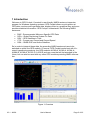
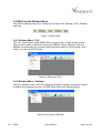
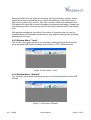
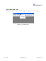
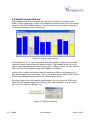
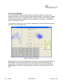
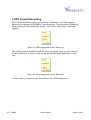
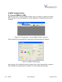
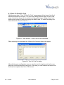
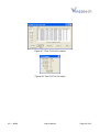
GPS Cockpit
A description of Vincotech’s Windows™ Software
for visualizing and analyzing positioning data
User’s Manual
Version 3.1
Software Revision 03
Revision History
Rev.
1.0
2.0
2.1
3.0
3.1
Date
01-20-04
03-12-07
07-09-07
06-30-08
09-02-08
Description
First release
Completely re-worked version; new description; new design
Added newly integrated features; release of new Cockpit
Adaptation to Vincotech, new features, correct support of A1082-A
Support of TTFF measurements; creation of Google Earth overlay
out of NMEA
mm-dd-yy
V3.1 - 09/08
User’s Manual
Page 2 of 25
Disclaimer
THIS DOCUMENT CONTAINS PROPRIETARY INFORMATION OF VINCOTECH
GMBH. IT MAY NOT BE COPIED OR TRANSMITTED BY ANY MEANS, PASSED
TO OTHERS, OR STORED IN ANY RETRIEVAL SYSTEM OR MEDIA, WITHOUT
PRIOR CONSENT OF VINCOTECH OR ITS AUTHORIZED AGENTS.
THE INFORMATION IN THIS DOCUMENT IS, TO THE BEST OF OUR
KNOWLEDGE, ENTIRELY CORRECT. HOWEVER, VINCOTECH CAN NEITHER
ACCEPT LIABILITY FOR ANY INACCURACIES, OR THE CONSEQUENCES
THEREOF, NOR FOR ANY LIABILITY ARISING FROM THE USE OR
APPLICATION OF ANY CIRCUIT, PRODUCT, OR EXAMPLE SHOWN IN THE
DOCUMENT.
THE PRODUCT (HARD- AND SOFTWARE) DESCRIBED IN THIS DOCUMENTATION IS NOT AUTHORIZED FOR USE IN LIFE SUPPORT DEVICES OR
SYSTEMS WITHOUT THE EXPRESS WRITTEN APPROVAL OF VINCOTECH.
THIS DOCUMENT MAY PROVIDE LINKS TO OTHER WORLD WIDE WEB SITES
OR RESOURCES. BECAUSE VINCOTECH HAS NO CONTROL OVER SUCH
SITES AND RESOURCES, VINCOTECH SHALL NOT BE RESPONSIBLE FOR
THE AVAILABILITY OF SUCH EXTERNAL SITES OR RESOURCES, AND DOES
NOT ENDORSE AND IS NOT RESPONSIBLE OR LIABLE FOR ANY CONTENT,
ADVERTISING, PRODUCTS, OR OTHER MATERIALS ON OR AVAILABLE
FROM SUCH SITES OR RESOURCES. VINCOTECH SHALL NOT BE
RESPONSIBLE OR LIABLE, DIRECTLY OR INDIRECTLY, FOR ANY DAMAGE
OR LOSS CAUSED OR ALLEGED TO BE CAUSED BY OR IN CONNECTION
WITH USE OF OR RELIANCE ON ANY SUCH CONTENT, GOODS OR
SERVICES AVAILABLE ON OR THROUGH ANY SUCH SITE OR RESOURCE.
VINCOTECH RESERVES THE RIGHT TO CHANGE, MODIFY, OR IMPROVE
THIS DOCUMENT OR THE PRODUCT DESCRIBED HEREIN, AS SEEN FIT BY
VINCOTECH WITHOUT FURTHER NOTICE.
V3.1 - 09/08
User’s Manual
Page 3 of 25
Table of Contents
1 Introduction ........................................................................................................ 5
2 General Information ........................................................................................... 6
2.1 System Requirements....................................................................................... 6
2.2 Highlights .......................................................................................................... 6
3 Getting Started ................................................................................................... 7
3.1 Installation ......................................................................................................... 7
3.2 First Touch ........................................................................................................ 7
3.3 Status Bar ......................................................................................................... 9
3.4 GPS Cockpit Window Menu ............................................................................ 10
3.4.1 Window Menu “File”.................................................................................................. 10
3.4.2 Window Menu “Settings” .......................................................................................... 10
3.4.3 Window Menu “Tools”............................................................................................... 11
3.4.4 Window Menu “Window”........................................................................................... 11
3.4.5 Window Menu “Help” ................................................................................................ 12
4 GPS Cockpit Windows..................................................................................... 13
4.1 Terminal Windows........................................................................................... 13
4.1.1 General Functions .................................................................................................... 13
4.1.2 Commands in NMEA Terminal Window ................................................................... 13
4.2 Satellite Signals Window................................................................................. 15
4.3 Sky View Window............................................................................................ 16
4.4 Survey Window ............................................................................................... 17
5 GPS Cockpit Recording................................................................................... 19
6 GPS Cockpit Tools........................................................................................... 20
6.1 Convert NMEA to KML.................................................................................... 20
6.2 Time To First Fix Test ..................................................................................... 21
7 Distribution....................................................................................................... 23
8 Related Information ......................................................................................... 24
8.1 Contact............................................................................................................ 24
8.2 Related Documents......................................................................................... 24
9 List of Figures .................................................................................................. 25
V3.1 - 09/08
User’s Manual
Page 4 of 25
1 Introduction
Welcome to GPS Cockpit, Vincotech’s user-friendly NMEA sentence interpreter
program for Windows operating systems. GPS Cockpit allows a quick glance at
GPS data, monitors and logs these data, displays them in a graphical way and even
provides statistical information. GPS Cockpit “understands” the following NMEA
sentences:
•
•
•
•
•
RMC - Recommended Minimum Specific GPS Data
GGA – Global Positioning System Fix Data
GSV – GPS Satellites in View
VTG – Course over Ground and Ground Speed
GSA – GNSS DOP and Active Satellites
So in order to interpret these data, the according NMEA sentences have to be
switched on within the GPS module. Of course, GPS Cockpit works best with Vincotech’s positioning products, the GPS modules A1080-A, A1082-A, A1084-A,
A1084-B, A1088-A, A1035-D, A1035-E and new ones that will be launched in the
future, but can also be used with any other GPS modules providing NMEA information.
Figure 1: Overview
V3.1 - 09/08
User’s Manual
Page 5 of 25
2 General Information
2.1 System Requirements
GPS Cockpit was designed to work with the operating systems Windows Vista,
Windows XP, and Windows 2000. The resolution of the graphic card should be
32bit.
2.2 Highlights
•
•
•
•
Only requires the GPSCockpit.exe and the *.chm files for getting started
Simply connect to the GPS receiver by using the USB or RS232 port
Recorded NMEA data can be used instead of the GPS receiver for simulation
Following general GPS information can be read
o Latitude
o Longitude
o Altitude
o GPS Quality (fix availability)
o Fix mode
o UTC time
o Sync PC time (synchronize your PC time)
• Statistical information in graphical representation
o Signal Quality
o Azimuth/Elevation
o Terminal program for monitoring NMEA data
o Precision, Deviation, Evaluation
• TTFF statistic tool
• Creation of Google Earth Overlay
V3.1 - 09/08
User’s Manual
Page 6 of 25
3 Getting Started
3.1 Installation
In order to install GPS Cockpit you just need to copy the two files
• GPSC 3.00.exe
• GPSC.INI
• Cockpit_help.chm
into a directory of your choice. You can create a shortcut to the executable in the
standard way and place this shortcut on your desktop or your program folder.
Your preferences will be stored in GPSC.INI. It will be created if the file does not
exist in the execution directory of the program. You can copy this file to use your
preferences in other directory or computer.
Note: The help file will only work if the above mentioned files are copied to the local
disk, not to any network drives (Microsoft security issue).
3.2 First Touch
After installation you can simply start GPS Cockpit by either double-clicking the executable itself or using a shortcut. The GPS Cockpit main window will pop up.
Figure 2: Start-up window
V3.1 - 09/08
User’s Manual
Page 7 of 25
In order to work with the NMEA data provided by a GPS receiver, you need to connect this receiver to your computer – either using the USB interface for e.g. Vincotech’s EVA1080-A, EVA1082A, or EVA1088-A or a COM port for e.g. the
EVA1035-D or the EVA1035-E. For details on the connection and a correct set-up,
please refer to the according manuals.
Now you need to activate the correct port within GPS Cockpit. You can do this by
either selecting “Port Number” in the “Settings” menu item or by simply clicking the
“Connect” button. In any case, the following window will appear:
Figure 3: Serial communication window - blank
Choose the COM port to which the GPS receiver was connected, in our example
COM11, set the baud rate (the default is 4800), and activate “NMEA Terminal”
(On/Off), then click on “OK”:
Figure 4: Serial communication window - selection
The connection is established now and you can open a terminal window to see
NMEA sentences by using the “NMEA Terminal” button. You should then see messages like this:
V3.1 - 09/08
User’s Manual
Page 8 of 25
Figure 5: Terminal window with messages
Now you can start using all the other windows and features of GPS Cockpit.
3.3 Status Bar
The status bar is giving you a quick overview on the mode of the survey window,
the UTC date and time, the fix status and record mode (on or off), as shown here:
Figure 6: Status bar
V3.1 - 09/08
User’s Manual
Page 9 of 25
3.4 GPS Cockpit Window Menu
The GPS Cockpit window menu consists of the items File, Settings, Tools, Window
and Help.
Figure 7: Menu items
3.4.1 Window Menu “File”
The “file” menu allows to play NMEA files, to record them, to stop recording and
playing and to define a speed for playing the NMEAs. Using “Send file” one can
transmit complete files (e.g. almanac and ephemeris data to a GPS module). And
finally, one can exit GPS Cockpit.
Figure 8: Sub-menu “File”
3.4.2 Window Menu “Settings”
With the „Settings“ menu, one can change general port settings, disconnect, launch
a window for programming keys, set SNR value levels and General setting.
Figure 9: Sub-menu “Settings”
V3.1 - 09/08
User’s Manual
Page 10 of 25
Setting the SNR level will affect two windows, the „Signal Quality“ window, where
signals below this threshold that are in use for calculating a fix will switch from a
blue color to yellow color, and the „Sky View“ window, where only satellites with a
CN0 above this value will be used for drawing the physical mask angle. Please note
that the setting of this value has no effect at all on the satellites used for calculating
a fix!
With general settings one can define if the metric or imperial system is used for
measurements and if degrees and minutes or only degrees (always with according
decimals) will be used.
3.4.3 Window Menu “Tools”
The “Tools” menu gives access to two functions: creating a Google Earth overlay
out of recorded NMEA data and doing time-to-first-fix (TTFF) measurements.
Figure 10: Sub-menu “Tools”
3.4.4 Window Menu “Window”
The “Window” menu allows arranging the open or minimized windows within GPS
Cockpit.
Figure 11: Sub-menu “Window”
V3.1 - 09/08
User’s Manual
Page 11 of 25
3.4.5 Window Menu “Help”
Using the “Help” menu one can open the integrated help manual (similar to this
manual), get version information, open a link to our homepage or send us an email.
Figure 12: Sub-menu “Help”
V3.1 - 09/08
User’s Manual
Page 12 of 25
4 GPS Cockpit Windows
4.1 Terminal Windows
4.1.1 General Functions
GPS Cockpit offers two terminal windows, the first window for the NMEA data, the
second window e.g. for debug data or the NMEA data of a second receiver. The
NMEA terminal window will open when the
NMEA Terminal button
is clicked. If you did connect already to a COM port with a GPS receiver, you will
see the NMEA data. If you did not connect before, you need to connect using the
COM port connection button
.
4.1.2 Commands in NMEA Terminal Window
In addition to that the NMEA terminal allows the programming of commands to buttons. In order to do so, please follow this sequence:
(1) Click the “Key Pad” selection in the “Settings” menu.
Figure 13: Setting window – key pad command
(2) Select the key, enter a button description (caption), enter the command sequence, and click OK.
Figure 14: Key pad dialog
V3.1 - 09/08
User’s Manual
Page 13 of 25
Afterwards, the commands will be available at a click on the according button. They
are transmitted to the connected receiver.
Figure 15: Issue command
You can also use the command line to enter commands manually. The list box will
show the recently used commands. As some receivers need a checksum, you can
append it by activating the (Checksum) control.
V3.1 - 09/08
User’s Manual
Page 14 of 25
4.2 Satellite Signals Window
The satellite signal window displays the signal to noise ratio or carrier to noise
(SNR or CN0, respectively) values of the satellites tracked by the GPS receiver and
reported in the GSV NMEA sentence. Therefore this sentence has to be switched
on. A typical situation might look like this:
Figure 16: Signal quality window
The numbers 13, 25, 4, etc. in the status area at the bottom represent the satellite
numbers or their Pseudo Random Noise numbers. The numbers at the top of the
signal quality bars display the current C/N0 value in dB/Hz. Values you can observe
with Vincotech GPS modules range from 15dB/Hz to 55dB/Hz.
A blue color or yellow color means that this satellite is used for calculating a fix, a
grey color means that it is as “seen”, but not used. Blue means that the CN/0 value
is above the defined minimum threshold, yellow means below.
By doing a right click in the satellite signal window, you can enter the “SNR level”
window for the satellite signals by choosing “Min. valid threshold”. You can enter
this menu by using the “Settings”, too.
Figure 17: SNR level window
V3.1 - 09/08
User’s Manual
Page 15 of 25
4.3 Sky View Window
The sky view window allows you to see the satellite positions in the sky directly.
The satellite numbers (or their PRN numbers) can be viewed along with the azimuth
and elevation values of each satellite, the satellite trails and the physical mask angle. To enable or disable features, a right click will give you the following menu
where you can choose different options.
Figure 18: Sky view window and properties
V3.1 - 09/08
User’s Manual
Page 16 of 25
4.4 Survey Window
The survey window allows to monitor and to analyze the quality, accuracy and
standard deviation of fixes for latitude, longitude and altitude. The window is divided
into three sub-windows, an altitude window, a position window and a data window.
The data window itself is divided in four sub-windows, a “Precision”, a ”Deviation”,
and an “Evaluation” window.
In the position window one can enter sub-menus doing a right-click with the mouse
as shown in the following picture.
Figure 19: Survey window
Selecting zoom one can choose between automatic mode or zoom factors between
25 and 400%. For plot mode either a line or points are available. Enabling the
sigma ellipse, the position window will show in addition the area defining the standard deviation of the fixes. And with pinpoint, the center of the window can be defined.
V3.1 - 09/08
User’s Manual
Page 17 of 25
With a left-click measurement of distance can be done, the first click setting the origin. While dragging the mouse pointer within the picture the distance is shown in
the right bottom corner. A second left-click will delete this origin again.
Figure 20: Distance measuring in the survey window
V3.1 - 09/08
User’s Manual
Page 18 of 25
5 GPS Cockpit Recording
GPS Cockpit allows the logging (or recording) of data into a file. Data logging is
started via a sub-menu in the NMEA Terminal window. The sub-menu is entered by
doing a right-hand click within this window. Just click on “Start Log” to start data
logging.
Figure 21: Data logging sub-menu “Start Log”
After starting a log a standard “Save As” menu will appear. Here you can enter file
location and name. In order to stop the log, proceed as before and click on “Stop
Log”.
Figure 22: Data logging sub-menu “Stop Log”
In order to this, you can also you the buttons in the GPS Cockpit menu.
V3.1 - 09/08
User’s Manual
Page 19 of 25
6 GPS Cockpit Tools
6.1 Convert NMEA to KML
With the menu item “Convert NMEA to KML” one can create an overlay for Google
Earth. Doing this, recorded positions can be displayed in Google Earth then automatically.
Figure 23: Tools window – convert NMEA to KML command
When selecting this command the following the following dialog will appear:
Figure 24: NMEA to KML dialog
After clicking “OK” the KML file will be created. If the “Start Google Earth” selection
was enabled and Google Earth is installed, it will be started automatically.
V3.1 - 09/08
User’s Manual
Page 20 of 25
6.2 Time To First Fix Test
With the menu item “ Time To First Fix Test” measurement of the time to first fix of
different modules can be done. The tool allows doing different types of tests (cold,
warm, hot starts), along with the selection of the module type, setting of time-outs,
defining the number of tests and logging the NMEA data. To initiate the dialog one
has to select the Time To First Fix
Figure 25: Tools window – time to first fix test command
When selecting this command the following the following dialog will appear:
Figure 26: Time To First Fix dialog
After defining your configuration you can start the test. A single as well as the complete test can be interrupted at any time. At the end you can create a test report that
itself can be exported as a file in CSV format.
V3.1 - 09/08
User’s Manual
Page 21 of 25
Figure 27: Time To First Fix results
Figure 28: Time To First Fix report
V3.1 - 09/08
User’s Manual
Page 22 of 25
7 Distribution
Vincotech grants the right to freely distribute GPS Cockpit along with its documentation in its original version in electronic format to everyone. GPS Cockpit is no
commercial product, therefore any form of charging or requesting donations is explicitly not allowed. As this product is freely available, there is no technical support
provided for this product
V3.1 - 09/08
User’s Manual
Page 23 of 25
8 Related Information
8.1 Contact
This manual was created with due diligence. We hope that it will be helpful to the
user to get the most out of the GPS module.
Anyway, inputs about errors or mistakable verbalizations and comments or proposals to Vincotech in Munich, Germany, for further improvements are highly appreciated.
Vincotech GmbH
Bibergerstr. 93
82008 Unterhaching (Munich)
Germany
Tel.: +49 89 8780 67 0
Fax: +49 89 8780 67 351
[email protected]
www.vincotech.com/gps
Further contact addresses:
[email protected]
[email protected]
[email protected]
8.2 Related Documents
Related documents are all Vincotech GPS receiver or smart antenna manuals, especially the firmware manuals. In addition, useful information is included in the
manuals for the different evaluation kits.
V3.1 - 09/08
User’s Manual
Page 24 of 25
9 List of Figures
Figure 1: Overview ................................................................................................... 5
Figure 2: Start-up window ........................................................................................ 7
Figure 3: Serial communication window - blank ....................................................... 8
Figure 4: Serial communication window - selection ................................................. 8
Figure 5: Terminal window with messages .............................................................. 9
Figure 6: Status bar.................................................................................................. 9
Figure 7: Menu items ............................................................................................. 10
Figure 8: Sub-menu “File” ...................................................................................... 10
Figure 9: Sub-menu “Settings” ............................................................................... 10
Figure 10: Sub-menu “Tools” ................................................................................. 11
Figure 11: Sub-menu “Window” ............................................................................. 11
Figure 12: Sub-menu “Help”................................................................................... 12
Figure 13: Setting window – key pad command..................................................... 13
Figure 14: Key pad dialog ...................................................................................... 13
Figure 15: Issue command..................................................................................... 14
Figure 16: Signal quality window............................................................................ 15
Figure 17: SNR level window ................................................................................. 15
Figure 18: Sky view window and properties ........................................................... 16
Figure 19: Survey window...................................................................................... 17
Figure 20: Distance measuring in the survey window ............................................ 18
Figure 21: Data logging sub-menu “Start Log” ....................................................... 19
Figure 22: Data logging sub-menu “Stop Log” ....................................................... 19
Figure 23: Tools window – convert NMEA to KML command ................................ 20
Figure 24: NMEA to KML dialog............................................................................. 20
Figure 25: Tools window – time to first fix test command....................................... 21
Figure 26: Time To First Fix dialog......................................................................... 21
Figure 27: Time To First Fix results........................................................................ 22
Figure 28: Time To First Fix report......................................................................... 22
V3.1 - 09/08
User’s Manual
Page 25 of 25