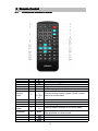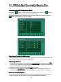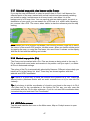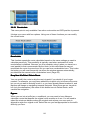
1
Thank you for your choosing our product. We hope you will find the instructions
on this user manual clearly and easily to follow. If you take a few minutes to look
through it, you’ll learn how to use all the features of your new Unit for maximum
enjoyment.
After you have finished reading the instructions, please keep this manual in a
safe place for future reference.
Note
Note:: 1. certain descriptions in this book may differ from the actual unit.
2. Some pictures or icons in the book may differ from actual display.
3. Specifications subject to change without notice.
1
Table of Contents
Part 1 Head Unit
1
2
3
4
5
6
7
8
9
Preparetion............................................................................................................ 6
1.1
Features......................................................................................................... 6
1.2
Tools and Supplies.........................................................................................6
1.3
Warnings........................................................................................................ 6
1.4
Disconnecting the Battery.............................................................................. 7
Controls and Indicators......................................................................................... 8
2.1
Button Operation............................................................................................ 8
2.2
LCD Display / Indicators...............................................................................10
Remote Control................................................................................................... 11
3.1
Front Zone Remote Control......................................................................... 11
TFT Monitor Operation........................................................................................ 13
4.1
Open/Close the TFT Monitor....................................................................... 13
4.2
TFT Monitor Auto Open............................................................................... 13
4.3
Monitor Tilt Angle Adjustment ...................................................................... 13
4.4
Image Setting............................................................................................... 13
4.5
Parking Brake Interlock................................................................................ 14
4.6
Monitor Movement Mechanism....................................................................14
Operating Instructions......................................................................................... 15
5.1
Power On / Off ............................................................................................ 15
5.2
Playing Source Selection ............................................................................ 15
5.3
AUX IN Mode .............................................................................................. 15
5.4
Volume Adjustment ..................................................................................... 15
5.5
Audio Control Menu .................................................................................... 15
5.6
System Reset .............................................................................................. 16
5.7
Mute ............................................................................................................ 16
System Setup Menu............................................................................................ 17
6.1
MAIN Menu.................................................................................................. 17
6.2
General Setup Menu.................................................................................... 17
6.3
ASP configuration Menu.............................................................................. 19
6.4
Screen Setup Menu..................................................................................... 20
Tuner Operation.................................................................................................. 22
7.1
Tuner TFT Display....................................................................................... 22
7.2
Switch to Radio Tuner source......................................................................23
7.3
Select FM/AM Band..................................................................................... 23
7.4
Auto Tuning.................................................................................................. 23
7.5
Manual Tuning............................................................................................. 23
7.6
Using Preset Stations...................................................................................23
7.7
Seek the PTY............................................................................................... 24
7.8
AF Function.................................................................................................. 24
7.9
TA Function.................................................................................................. 24
DVD/CD Player Operation...................................................................................25
8.1
Opening/Closing the TFT Video Screen...................................................... 25
8.2
Insert/Eject Disc........................................................................................... 25
8.3
Reset the Loading Mechanism.................................................................... 25
8.4
Accessing DVD/CD Mode............................................................................ 25
DVD/CD/MP3/WMA/JPEG Operation................................................................. 26
9.1
DVD player...................................................................................................26
9.1.1
General setup....................................................................................... 27
9.1.2
language menu..................................................................................... 28
2
9.1.3
Setting password of Rating..................................................................28
9.2
CD Player User Interface............................................................................. 29
9.3
MP3/WMA Discs.......................................................................................... 30
9.4
JPEG Discs.................................................................................................. 31
10 Navigation Operation...........................................................................................32
10.1 Access the Navigation mode....................................................................... 32
10.2 Navigation Operation................................................................................... 32
10.3 How to Listen to an Audio program While Using/viewing the Navigation....32
11 Troubleshooting...................................................................................................33
12 Specifications...................................................................................................... 37
Part 2 Navigation
1
2
3
Warnings and safety information.........................................................................39
General information............................................................................................. 40
Discovering the program through the screens.................................................... 41
3.1
Main menu....................................................................................................41
3.2
About screen................................................................................................ 42
3.3
The map....................................................................................................... 42
3.3.1
2D and 3D map views...........................................................................42
3.3.2
Zoom levels...........................................................................................43
3.3.3
Daylight and night colour schemes.......................................................44
3.3.4
Streets and roads..................................................................................45
3.3.5
Other objects.........................................................................................46
3.3.6
Current position and Lock-on-Road......................................................46
3.3.7
Selected map point, also known as the Cursor.................................... 47
3.3.8
Marked map points (Pin).......................................................................47
3.4
GPS Data screen......................................................................................... 47
3.4.1
GPS data displayed.............................................................................. 48
3.4.2
GPS connection indicator..................................................................... 48
3.4.3
GPS data quality indicator.................................................................... 49
3.4.4
Time synchronization............................................................................ 49
3.5
Screens with map.........................................................................................50
3.5.1
Turn preview (No. 1)............................................................................. 52
3.5.2
Zoom in and out (No. 2 & 3)................................................................. 52
3.5.3
Tilt up and down (No. 4 & 5)................................................................. 52
3.5.4
Follow mode - lock to GPS position and heading (No. 6).....................53
3.5.5
Cursor (No. 7)....................................................................................... 54
3.5.6
Map scale (No. 8)..................................................................................54
3.5.7
Menu (No. 9)......................................................................................... 54
3.5.8
Map orientation and Overview (No. 10)................................................54
3.5.9
GPS position quality (No. 11)............................................................... 55
3.5.10 Sound muting (No. 12)..........................................................................56
3.5.11 Track Log recording/playback indicator (No. 13)..................................56
3.5.12 Cursor menu (No. 14)........................................................................... 56
3.5.13 Current street (No. 15).......................................................................... 58
3.5.14 Travel and Route data (No. 16)............................................................ 58
3.5.15 Distance to next turn (No. 17)...............................................................59
3.5.16 Next street / Next settlement (No. 18).................................................. 59
3.5.17 Approaching next turn (No. 19).............................................................59
3.6
Menu............................................................................................................ 60
3.6.1
Find tab................................................................................................. 60
3.6.2
Quick tab............................................................................................... 60
3
3.6.2.1
3D Map (switch).............................................................................60
3.6.2.2
Zoom & Tilt (switch).......................................................................61
3.6.2.3
Night Mode (switch).......................................................................61
3.6.2.4
Popup Information (switch)............................................................61
3.6.2.5
Manage Track Logs.......................................................................62
3.6.3
Route tab.............................................................................................. 63
3.6.3.1
Recalculate.................................................................................... 64
3.6.3.2
Delete............................................................................................ 65
3.6.3.3
Itinerary..........................................................................................65
3.6.3.4
Fly Over......................................................................................... 67
3.6.3.5
Edit.................................................................................................67
3.6.3.6
Info................................................................................................. 68
4 Settings................................................................................................................69
4.1
General settings........................................................................................... 69
4.1.1
Safety Mode..........................................................................................69
4.1.2
Set Favourite Destinations....................................................................69
4.1.3
Automatic Night Colours....................................................................... 70
4.1.4
Route Recalculation..............................................................................70
4.1.4.1
Automatic.......................................................................................70
4.1.4.2
Ask First.........................................................................................70
4.1.4.3
Disabled.........................................................................................71
4.2
Map settings................................................................................................. 71
4.2.1
Daylight / Night colour profile................................................................72
4.2.2
Alternative Road Names.......................................................................72
4.2.3
Show Street Labels...............................................................................72
4.2.4
Textured Polygons................................................................................ 72
4.3
Route parameter settings.............................................................................72
4.3.1
Method.................................................................................................. 73
4.3.2
Route.....................................................................................................73
4.3.2.1
Short.............................................................................................. 73
4.3.2.2
Fast................................................................................................ 73
4.3.2.3
Economical.................................................................................... 73
4.3.3
Vehicle.................................................................................................. 73
4.3.4
Road types to include/exclude..............................................................74
4.3.4.1
Unpaved Roads............................................................................. 74
4.3.4.2
Motorways..................................................................................... 74
4.3.4.3
Ferries............................................................................................74
4.3.4.4
U-turns........................................................................................... 74
4.3.4.5
Permit needed............................................................................... 75
4.3.4.6
Toll Roads......................................................................................75
4.4
Language & Units.........................................................................................75
4.4.1
Program language................................................................................ 75
4.4.2
Voice language..................................................................................... 76
4.4.3
Units...................................................................................................... 76
4.4.4
Set Date & Time Format....................................................................... 76
4.5
Advanced settings........................................................................................76
4.5.1
Display options......................................................................................77
4.5.1.1
2D in Map mode (and North-up orientation)..................................77
4.5.1.2
3D in Cockpit mode (and track-up orientation)..............................77
4.5.1.3
Zoom in after find...........................................................................77
4.5.1.4
Coordinate display format..............................................................78
4.5.1.5
Cockpit screen layout.................................................................... 78
4
Part 1 Head Unit
N420i (V02)
5
1 Preparation
Please read all of the instructions before beginning the installation. We
recommend having your unit installed by a credible installation shop.
1.1 Features
�
�
�
�
�
�
�
�
�
�
�
Single DIN size, all-in-one integrated entertainment system.
Built-in DVD Player, automotive specification slot loading mechanism.
Built-in RDS FM/AM Tuner.
SD card reader with READ functionality.
High resolution 7” (16:9) TFT color monitor, contrast and brightness
adjustment, with LCD dot matrix display.
Built-in 40W X 4 amplifier, 3.5 channel surround sound output.
Turn out and slot-in panel structure.
Smart Touch-screen operation.
Buttons and Encoder operation.
Built-in Navigation Control.
All functions can be operated by included Remote Control.
1.2 Tools and Supplies
You will need these tools and supplies to install your unit.
• Torx type, flat-head and Philips screwdrivers
• Wire cutters and strippers
• Tools to remove existing radio (screwdriver, socket wrench set or other tools)
• Electrical tape
• Crimping tool
• Multimeter
• Crimp connections
• 18 gauge wire for power connections
• 16 – 18 gauge speaker wire
• Heatshrink tubing
• Soldering iron and solder
1.3 Warnings
1. Only connect the unit to a 12-volt negative ground system.
2. Never install this unit where operation and viewing could interfere with safe
driving conditions.
3. To reduce the risk of a traffic accident (except when using for rear view video
camera) never use the video display function while driving the vehicle. This
may be in violation of local laws.
4. To reduce the risk of a traffic accident, never drive with the sound at a level
that prevents you from hearing sounds outside around the vehicle.
5. Never disassemble or adjust the unit without the assistance of a professional.
For details, please consult your local car stereo specialty shop.
6. To prevent injury from shock or fire, never expose this unit to moisture or
water.
7. Never use irregular discs, the only recommended disc size is a 12cm round
disc.
8. To prevent damage to the mechanism inside this unit, avoid impact to the TFT
monitor.
9. Do not change the fuse on the power wire without professional guidance.
Using an improper fuse may cause damage to the unit and result in a fire.
6
10. The monitor employs an automatic motorized mechanism. To prevent
damage to the core mechanism, please do not push, pull or swivel the
monitor manually.
1.4 Disconnecting the Battery
To prevent a short circuit, turn off the ignition and remove the negative (-) battery
cable prior to starting the installation.
Note
Note:: If the unit is to be installed in a car equipped with an on-board drive or
navigation computer, do not disconnect the battery cable. If the cable is
disconnected, the preset memory may be erased. Under these conditions, use
extra caution during installation to avoid causing a short circuit.
Note
GS and NOT
ES in this
Note:: It is especially important that you read the WARNIN
WARNINGS
NOTES
manual.
7
2 Controls and Indicators
2.1
Button Operation
AS/PS (Auto store/program scan)
1.AS/PS
Press to auto store strong radio stations in the 6 preset channels in the current
band.
Press and hold to start to scan radio stations stored in the 6 preset channels in
the current band.
BAND
2.BAND
Press to change among the following bands: FM1、FM2、FM3、AM1、AM2.
3. LCD DISPLAY
4. IR REMOTE CONTROL RECEIVER
POWER/VOL
5.POWER/VOL
Rotary encoder.
Press the encoder to turn on the unit, press and hold to turn off.
Rotate clockwise/counterclockwise to adjust the volume.
Press to enter the audio adjust menu when the unit is on.
6. SRC
Press to select a source.
7. PREVIOUS
Select the previous chapter/track for playback.
Seek an available radio station by decreasing tuning frequency
8
8. MUTE
Press the MUTE button to mute the volume, and press the button again to
restore the volume.
9. NEXT
Select the next chapter/track for playback.
Seek an available radio station by increasing tuning frequency
10. SCAN
Press the button to activate/deactivate Scan Mode.
Press and hold the button to activate/deactivate Traffic Announcemen (TA)
function.
SD
11.SD CARD SLOT
12. RESET
Use this button to restart the machine.
13. SMART DIAL
Rotary encoder.
Press the encoder to access MAIN menu.
Rotate clockwise/counterclockwise to select a desired item and press to
access or confirm.
14. EJECT
Press once for disc insertion/ejection.
15. DISC INDICATOR LIGHT
It is blue when there is no disc in the slot, otherwise, it is red.
16. OPEN
Press the button to activate the motorized system and move the TFT monitor
into viewing position. Press again to close the TFT.
17. SHORT WAY TO SWITCH TO THE NAVIGATION SOURCE
18. DISC SLOT
INFO
/PICTURE
19.INFO
INFO/PICTURE
Press to display the playing information on the screen on Navigation mode.
If the TFT monitor is closed, the playing information will display on the LCD
screen.
Press and hold to access the picture setup.
ANGLE
20.ANGLE
Press the button to adjust the upward tilt angle of the screen one step at a
time.
Press and hold this button to continuously adjust the upward tilt.
Press this button to adjust the picture settings in picture setup.
ANGLE
21.ANGLE
Press the button to adjust the downward tilt angle of the screen one step at a
time.
Press and hold this button to continuously adjust the downward tilt.
Press this button to adjust the picture settings in picture setup.
TFT DISPLAY
22.TFT
9
2.2
LCD Display / Indicators
1. Main display area, displays the time, tuning frequency and other text
information.
2. Loudness indicator, Indicates the LOUD function is activated or not.
3. Alternative Frequency (AF) indicator.
4. Traffic Announcement (TA) indicator.
5. Traffic Program (TP) indicator.
6. Program Type (PTY) indicator.
7. Stereo broadcasting indicator, Indicates the radio is in stereo mode or not.
8. Local indicator, Indicates the local radio station seeking function is activated
or not.
10
3 Remote Control
3.1
Front Zone Remote Control
Name
Power
Open
Mute
MODE
Numeric
button
Ref #
1
2
3
4
5
Signal
OPEN
MUTE
MODE
1.2.3.4.
5
6.7.8.9.
0
Function
Turn the power on/off
Open/close the TFT monitor
Toggles on/off audio output
Select playing mode
Directly access certain chapter / track / preset
station in current band
VOL up
VOL down
Information
GOTO
search
6
7
8
Increase the volume
Decrease the volume
Display playing information
9
Position search function on DVD/CD mode
Stop/Band
10
Select
ESC
Menu
11
12
13
Selects FM/AM band on Tuner mode
Stop playback on others mode
Enter the audio settings
Exit the current menu
Enter the main menu of system
11
Picture
Repeat
A�B
OK
Direction
buttons
14
Title
18
Root
Repeat
19
20
Next
21
Previous
22
Fast
Reverse
Fast
Forward
Audio
Zoom
Angle
SUB Title
16
Adjust the parameter of TFT settings
Set start point A and end point B to repeat
continually
Start or pause playback, confirm the settings
17
Up/down/left/right to select items for setting
15
Also can activate and disable SCAN mode while
playing DVD/CD
Enter the main menu of the disc
Repeat playback for current chapter
Select the next chapter/track for playback on
DVD/CD mode
Search an available radio station by increasing
tuning frequency on tuner mode
Select the previous track for playback on
DVD/CD mode
Search an available radio station by decreasing
tuning frequency on tuner mode
23
Fast reverse the disc content of DVD/CD
24
Fast forward the disc content of DVD/CD
25
26
27
28
/
/
Play in different angle for a scene
/
12
4 TFT Monitor Operation
4.1
Open/Close the TFT Monitor
OPEN
Press the (OPEN
OPEN) button on the front panel or press the OPEN button on the
remote control to open/close the monitor.
4.2
TFT Monitor Auto Open
If “TFT Auto Open” is “On”, when the unit is turned on, the monitor automatically
opens to the last viewing position, and closes automatically when the unit is
turned off.
If “TFT Auto Open” is “Off”, when the unit is turned on, the monitor will not open
automatically, but will close automatically when the unit is turned off. You can
OPEN
press the (OPEN
OPEN) button on the front panel or the OPEN button on the remote
control to move the monitor into the desired viewing position.
If “TFT Auto Open” is “Manual”, when the unit is turned on or turned off, the
monitor has no movement.
See “General setting” for details.
4.3
Monitor Tilt Angle Adjustment
The monitor angle can be adjusted for optimum viewing using one of the
following methods:
Press the ( ) or ( ) buttons on the front panel to adjust the tilt angle of the
screen one step at a time.
Press and hold the ( ) or ( ) buttons to continuously adjust the tilt angle.
Adjust the “Screen Tilt” in the “Screen setting” to adjust the tilt of the screen to
the desired degree.
4.4
Image Setting
Video Output Format
The table below shows the video output format for each source.
Video Output Format
Playing Source
Video Output Format
FM/AM Tuner
RGB Mode
DVD/CD
RGB Mode
NAVI
RGB Mode
CAMERA
CVBS Mode
AUX IN
CVBS Mode
*CVBS-- Composite Video Base band Signal
Adjustable Parameters
While on RGB mode, the only parameter that can be adjusted is brightness
(BRIGHT). To access“PICTURE”, “COLOUR”, “CONTRAST” and “BRIGHT”,
you must be on CVBS mode.
Parameter Adjustment Procedure
1. Enter Picture Quality Setting Mode:
Press the PIC button on the remote or press and hold the INFO button on the
front panel of the unit.
s to Set:
2. Select Item
Items
Press the ( / ) buttons on the remote or rotate the SMART DIAL button
clockwise / anticlockwise to select an item on CVBS mode.
13
3. Set Parameters:
Press the ( / ) buttons on the remote or press the ANGLE button ( / ) on
the front panel to adjust the selected feature to the desired setting. Rotate the
“VOL” on the front panel can also adjust the selected feature.
4. Exit Picture Quality Setting Mode:
Press the PIC button on the remote or press and hold the INFO button on the
unit.
4.5
Parking Brake Interlock
1. Parking brake function is overridden when the video source is set to CAMERA
2. When the “parking brake interlock” is active, the front monitor displays a
caution message with a blue background, preventing the driver from watching
video while driving.
3. All of the above setup. Prevent the drive from disturbing, ensure safe driving.
Please see “INSTALLATION SECTION” for installation.
4.6
Monitor Movement Mechanism
If an obstruction occurs on the monitor path, the motion will stop automatically to
prevent damage for the mechanism or monitor.
Normal operation is resumed by pressing the OPEN button or disconnecting and
reconnecting the power.
14
5 Operating Instructions
5.1
Power On / Off
Press the POWER/VOL button to turn the unit on. The buttons on the front of the
unit are illuminated and start up message is briefly displayed on the LCD screen,
and then displays the current mode status. You can also turn on the unit by
pressing the ( ) button on the remote control.
Press and hold the POWER/VOL button on the front panel for more than 1
second or press the ( ) button on the remote to power off the unit. The monitor
is drawn back into the main compartment and the LCD screen displays “BYE
BYE”.
NOTE: The operating voltage range is 10.5V - 16V. The unit will power off
automatically to protect itself, when the voltage is out of the operating range.
5.2
Playing Source Selection
Press the SRC button on the front panel or the MODE button on the remote to
select among the available sources: TUNER, DVD, NAVI, AUX IN, Camera. The
selected playing mode is displayed on the TFT or LCD screen.
5.3
AUX IN Mode
An external peripheral device can be connected to this unit via RCA cables to
the “AUX-IN”.
5.4
Volume Adjustment
To increase or decrease the volume level, turn the POWER/VOL on the front panel or press
VOL+/ VOLthe (VOL+/
VOL-) buttons on the remote control. The volume ranges from “0” to “40”. The
default volume is “10” when the unit is powered on each time. Default volume memory setup:
Rotate Power/VOL knob on the front panel to select volume value and then press and hold
the Power/VOL button until you hear a single beep. When you hear the beep, setup is
completed.
5.5
Audio Control Menu
The Audio Control feature allows you to easily adjust your audio system to meet
the acoustical characteristics of your vehicle, which vary depending on the type
of vehicle and its measurements. To get the best possible sound quality from
your new system, be sure to adjust the settings for the speakers as well. Proper
setting of the Fader and Balance enhances the effects of the cabin equalizer.
Accessing the Audio Control Menu
SEL) button on the
Press the POWER/VOL on the front panel once or press the (SEL)
remote control to enter the “Audio” menu.
Selecting an Audio Feature for Adjustment
Press the / buttons on the remote to select a item to be adjusted.
Rotate the “Smart Dial ”on the front panel to select a item to be adjusted.
Adjusting an Audio Feature
Press the ( / ) buttons on the remote or rotate the POWER/VOL
clockwise/counterclockwise to adjust the selected feature to the desired setting.
15
Audio Adjustments
Audio Function
Adjustable Range
User
Flat
Jazz
Pop
Classic
Rock
News
Urban
Rave
Movie
Techno
-7 to +7
-7 to +7
-9 to +9
-9 to +9
-7 to +7
Off, Level1-4
EQ
BASS
TREBLE
FADE
BAL
SW
LOUD
Note
Note:: The Bass and Treble levels are only adjustable when EQ is on “User”
mode.
The Loudness function compensates for deficiencies in sound ranges at low
levels. Loudness levels range from 1-4 or “off”. When the Loudness function is
on, LOUD is displayed on the screen.
Exiting the Audio Control Menu
Press and hold the POWER/VOL button on the front panel to exit the audio
control menu or press the escape arrow on the top right corner of the TFT
display.
ESC) button on the remote control to exit the audio control menu.
Press the (ESC)
5.6
System Reset
To correct a system halt or other illegal operation, use the tip of a pen to press
the RESET button located on the front bottom-right corner of the unit. After a
system reset, the unit system setup restores the setting before last power off.
5.7
Mute
Press the MUTE button on the front panel or the MUTE button on the remote to
mute the volume from the unit.
Note
Note:: Press the MUTE button again to restore the volume.
Adjusting the volume or using any of the audio set-up features will cancel the
mute function.
16
6 System Setup Menu
6.1 MAIN Menu
There are three methods to access the MAIN menu.
·Press the SMART DIAL button on the front panel.
·Press the MENU button on the remote control.
·Touch the top left corner on the touch-screen.
1. Touch to access Tuner mode.
2. Touch to turn to the previous menu.
3. Touch to access DVD/CD mode.
4. Touch to access General setup.
5. Touch to access AUX IN mode.
6. Touch to access Camera mode.
7. Touch to access Navigation mode.
Note: Remote, touch screen operations and buttons on front panel are all use
able to select menu and adjust settings. The following instructions will show the
different ways to access menus and adjustments.
6.2
General setup Menu
Accessing the General Setup Menu
·Select the
setup.
button on the bottom of the touch screen to access the General
17
Selecting a Feature for Adjustment
Press the direction buttons on the remote control or touch the option directly on
the screen to select the feature to be adjusted.
Adjusting a Feature
OK)
1. Enter the option field for the feature you want to adjust by pressing the (OK)
button on the remote or by pressing the SMART DIAL button. A submenu
appears in a second row with the selected option.
2. Select a new value by pressing the direction button.
OK) button or pressing the SMART DIAL
3. Confirm your selection by pressing (OK)
button. The new value setup is complete.
Adjusting the Clock
1. Access the “Clock” setting under the General Setup menu.
2. Press the direction button on the remote to move the cursor to the “Hour” or
OK) button. You also can touch the “Hour” or
“Min” position, and press the (OK)
“Min” position directly.
3. The numeric keypad will pop up.
4. Press the numeric button on the remote control or touch the numeric keypad
on the screen to adjust the hour or minutes.
OK) button on the remote control or on the keypad of the screen to
5. Press the (OK)
confirm setup.
Return to normal playback
1.The system will automatically return the previous playback mode that it was in
before accessing the setup menu 20 seconds after the last operation.
2.Select the
button on the bottom of the screen, and the system will return
the previous playback mode.
Note: Select the
button on the bottom of the screen, and the system will
access the MAIN menu.
Setting
Radio
Clock
Clock Mode
Camera
Image
Video Format
Options
USA
S-America
Europe
(HH:MM)
12Hr
24Hr
Normal
Reverse
Auto
NTSC
PAL
On
TFT Auto
Open
Off
Manual
Function
Select the appropriate setting based on the
country in which you reside.
See “Adjusting the clock” to learn how to set the
clock.
Clock displays 12 hour time using AM and PM.
Clock displays 24 hour time up to 23:59
The output of Camera Image is in normal mode
The output of Camera Image is in reverse mode
Selecting Video Format.
The TFT panel automatically opens when the unit
is turned on.
You must press the OPEN button on the TFT
panel or on the remote to open the TFT.
The monitor does not open or close when the unit
is turned on or turned off.
18
6.3
ASP(Audio Signal Processing) Config
uration Menu
Configuration
The ASP Configuration menu allows you to make fine audio adjustment.
uration Menu
Accessing the ASP Config
Configuration
Select the
button on the bottom of the screen, then Select the
button
on the bottom of the screen to access the ASP setup.
A menu appears with the option for the first item, and then you can touch the
button to the option on the next page.
Selecting a Feature for Adjustment
Press the direction buttons on the remote control or touch the option directly on
the screen to select a feature to be adjusted.
Adjusting a Feature
OK)
1. Enter the option field for the feature you want to adjust by pressing the (OK)
button on the remote or by pressing the SMART DIAL
DIAL. A submenu appears in
a second row with the selected option.
2. Select a new value by pressing the direction button.
OK) button on the remote control or
3. Confirm your selection by pressing (OK)
pressing the SMART DIAL on the front panel. The new setup is complete.
Return to normal playback
The system will automatically return the previous playback mode that it was in
before accessing the setup menu 20 seconds after the last operation.
19
Setting
Bass Freq
Treble Freq
Options
60Hz
80Hz
100Hz
200Hz
10KHz
12.5KHz
15KHz
17KHz
80Hz
Sub Filter
120Hz
160Hz
Off
Navi-Mix
On
Bass QFactor
TA
FM/AM Gain
DVD Gain
AUX IN Gain
NAVI Gain
1.0
1.25
1.5
2.0
Off
On
-07 ~ +07
-07 ~ +07
-07 ~ +07
-07 ~ +07
Function
Depending on the audio source, select the Bass
Center Frequency to achieve the best Bass effect.
Depending on the audio source, select the Treble
Center Frequency to achieve the best Treble effect.
Selecting a crossover frequency sets a cut-off
frequency of the subwoofer’s LPF(low-pass filter)
and the “SMALL” speakers’ HPF (high-pass filter).
The Crossover frequency setting has no effect if the
subwoofer is set to “Off” and any other speaker is
set to “Large”.
When there is navigation audio output, the current
audio will be switched automatically to navigation
audio output.
When there is navigation audio output, the current
audio will be synchronized with navigation audio
output.
When the Bass Center Frequency is selected,
adjusting the Bass Q-Factor alters the sharpness of
the Bass output.
Touch to deactivate TA
Touch to activate TA. When a traffic announcement
is received, the current playing source is overridden
by the traffic announcement automatically
Adjust the FM/AM gain
Adjust the DVD gain
Adjust the AUX IN gain
Adjust the NAVI gain
6.4 Screen Setup Menu
Accessing the Screen Setup Menu
Select the
button on the bottom of the screen, then Select the
on the bottom of the screen to access the screen setup.
20
button
Selecting a Feature for Adjustment
Press the (
/
) buttons on the remote to select a feature to be adjusted.
Rotate SMART DIAL clockwise/counterclockwise to select a feature to be
adjusted.
Directly touch the options on the screen to select a feature to be adjusted.
Adjusting a Feature
Setting
Options
Brightness
Screen Tilt
Screen Saver
TS Calibrate
Version
00 to 20
1 to 6
On
Off
No
Yes
Function
Press the ( / ) buttons on the remote or
rotate the SMART DIAL
clockwise/counterclockwise to adjust the
brightness to the desired setting.
Press the ( / ) buttons on the remote or
touch the (1 to 6) number on the screen
directly to adjust the tilt of the screen to the
desired degree.
Touch to activate/deactivate the Screen
Saver.
Touch “Yes” to enter the touch screen
calibration mode.
The version of this unit.
21
7 Tuner (FM/AM) Operation
7.1
Tuner TFT display
1. Current Source information, touch this area to return to MAIN menu.
2. Current Radio Band Indicator.
3. Current Preset Station playing Indicator.
4. Stereo Broadcast Indicator.
5. System EQ setting.
6. Loud Setting Indicator.
7. Volume Indicator.
8.
:Touch to change among the following bands: FM-1, FM-2, FM-3, AM-1,
AM-2.
9.
:Touch to automatically scan and store stations in current radio band.
You also can press the AS/PS button on the front panel.
10.
:Touch to seek down.
11.
:Touch to seek up.
12.
13.
:Touch to tune down one step.
:Touch to tune up one step.
14.
:Touch to activate/deactivate Scan Mode.
15. Touch to activate/deactivate TA (Traffic Announcement) function.
16. Touch to activate/deactivate AF (Alternative Frequency) function.
17. Touch to activate/deactivate PTY (Program Type) function.
18. Current time Indicator.
19. Preset Radio Stations: Touch to recall preset stations or touch and hold to
store a station. (Total 6 stations per Band you can preset.)
20. Display Program Type.
21. Radio Frequency Indicator.
Note
Note:: This product features a tuner with RDS function, RDS (Radio Data System)
is a system that transmits broadcast station information together with FM
programs.
22
You get display of Program Service Name and PTY, tuning to stations
broadcasting a desired PTY, automatic tuning to traffic information, and
emergency broadcasts and radio text display.
RDS service was not available in AM broadcasting. RDS service availability
depends on the FM broadcasting provider.
7.2
Switch to Radio Tuner source
Press the SRC button on the front panel or press the MODE button on the
remote control to switch to the Tuner source .You can also access the tuner
mode from the MAIN menu directly.
7.3
Select FM/AM Band
Touch the
button on the screen or press the( )button on the remote
control to change among the following bands: FM-1、FM -2、 FM-3、AM-1、
AM-2.
Auto Store (AS) – Shown By Radio Frequency
Press the AS/PS button on the panel or press the
button on the screen to
scan automatically and store strong radio stations in the 6 preset channels in the
current band.
Auto Store (AS) – Shown By Radio Station Name
AF
Touch [AF
AF] in the screen, then press the AS/PS button on the panel or press the
button on the screen to scan automatically and store strong radio stations in
the 6 preset channels in the current band.
Program Scan (PS)
1. Press and hold the AS/PS button on the panel to scan automatically the
stations stored in the 6 preset channels in the current band.
2. Touch the
button on the screen to scan automatically all stations in the
current band to preview station.
3. Press any button to stop scanning and listen to the selected station.
7.4
Auto Tuning
Press the button ( ) on the remote control or touch the
button on the screen
to seek the next available channel by decreasing the tuning frequency. Press the
button again to stop searching.
Press the button ( ) on the remote control or touch the
button on the screen
to seek the next available channel by increasing the tuning frequency. Press the
button again to stop searching.
7.5
Manual Tuning
Touch the
7.6
or
to increase or decrease the tuning frequency one step.
Using Preset Stations
6 numbered preset buttons store and recall stations for each band. 6 stored
stations (P01-P06) for the current band appear on the screen, touch the channel
directly to select.
You can touch the arrow buttons
on the screen to select other stations.
23
Storing a Station
1. Select a band (if needed), then select a station.
2. Touch and hold an onscreen preset button for three seconds. The preset
number appears at the top of the screen.
Recalling a Station
1. Select a band (if needed).
2. Touch an onscreen preset button to select the corresponding stored station.
7.7
Seek the PTY (Program Type)
Touch
in the screen to enter PTY menu, then touch to select one in the PTY
menu, the unit will auto seek the next available PTY by increasing tuning
frequency until the program type matches the PTY, if no matched was found ,the
tuner will return to original radio and “None” is displayed .
7.8
AF (Alternative Frequency/Auto Following) Function
Touch
in the screen to activate/deactivate AF function. When AF is activated
and a radio signal is too weak, the tuner automatically switches to the best
alternative frequency.
Note: During auto switching radio frequency, some interference could be heard.
Turn off AF function can cease this issue.
7.9
TA (Traffic Announcement) Function
Touch
in the screen to activate/deactivate TA function. When TA is activated,
the unit will auto seek an available TP or TA station .After the seeking, no
matter if PTY was found, the tuner will auto seek each 1 minutes.
When TA is activated and a traffic announcement is received, the current playing
source is overridden by the traffic announcement automatically, if the tuner was
last set to the FM band but not if it was last set to the AM band. When traffic
announcement is over, the current playing source will be resumed.
Note: There are three methods to activate/deactivate TA function.
· Touch
on the screen on Tuner mode.
· Press and hold the SCAN button on the front panel .
· Touch TA option directly on the screen on ASP SETUP mode, then select
the OFF/ON option of submenu appeared in the second row.
24
CD Player Operation
8 DVD/
DVD/CD
8.1
Opening/Closing the TFT Video Screen
Opening the TFT Screen
To open the TFT video screen, press the OPEN button on the unit or press the
OPEN button on the remote control.
Closing the TFT Screen
Press the OPEN button on the unit or press the OPEN button on the remote
control again to close the TFT screen.
8.2
Insert/Eject Disc
ting a Disc
Inser
Inserting
When inserting a DVD/CD disc, DVD/CD mode is entered and disc play begins.
Note
ote:: You cannot insert a disc if there is already a disc in the unit or if the power
is off.
Ejecting a Disc
Press the button on the unit to eject the disc. The unit automatically reverts to
tuner mode at the same time.
8.3
Reset the Loading Mechanism
If the disc loads abnormally or does not play properly, press and hold the button
on the unit to reset the loading mechanism. The disc is ejected and normal
operation resumes.
8.4
CD Mode
Accessing DVD/
DVD/C
To switch to DVD/CD mode when a disc is already inserted, press the SRC
button on the front panel or press the MODE button on the remote control until
DVD/CD appears at the top of the screen.
25
CD/MP3/WMA
/JPEG Operation
9 DVD/
DVD/CD/MP3/WMA
CD/MP3/WMA/JPEG
Instructions for Insert/Eject, Play/Pause, Stopping Playback, Track Selection,
Fast Forward/Fast Reverse, Scan, and Random Play are the same for DVD/CD
and MP3 operation. Please see the DVD/CD Player Operation section for
information about these topics.
The file naming formats listed below are compatible with this unit:
• ISO 9660 – file name: 12 characters, file extension: 3 characters
• ISO 9660 – file name: 31 characters, file extension: 3 characters
• Joliet – 64 characters
If the file or folder name does not conform to ISO 9660 file system standards, it
may not be displayed or played back correctly.
9.1 DVD player
After inserting a DVD disc , choose a DVD mode by mode button or press to the
DVD button of the main menu ,then the monitor displays DVD programme .
·Touch the bottom of the touchscreen to show buttons of the touchscreen
below while playing DVD .
1. Touch to play/pause
2. Touch to stop: disc playback
3. Touch to be fast backward current track
4. Touch to be fast forward current track
5. Touch to activate/deactivate Repeat Single Mode
6. Touch to activate/deactivate Repeat of A to B
7. Touch to select mono/stereo audio mode
8. Touch to exit buttons of the touchscreen
9. Touch to access the subtitles if available. (Scroll through all languages to turn
off subtitles.)
26
·Touch the left up corner of the screen while playing DVD to access the main
menu
·Touch the right up corner of the screen while playing DVD to access the
search menu below
Touch to select the playing time and title/chapter then input the numeric buttons
to the white underlines.
9.1.1 Select the
below.
button on the main menu to access the General setup
27
9.1.2 Touch the DVD button
language menu below
1.
2.
3.
4.
of General setup menu to access the
Touch to set the languages
Touch to set the video mode
Touch to set passwords /rating / load factory functions
Touch to exit
9.1.3 Touch
to access setting password of Rating below .
The master password is 8888 and default password of the load factory is also
8888. After inputting the correct password, the “8.Adult” of the Rating is high
lightened and then selects the menu by touching “8.Adult”. If forgetting the
password that is set by user, the master password of 8888 can be used.
28
9.2 CD Player User Interface
1.
2.
3.
4.
5.
6.
7.
8.
9.
10.
11.
12.
Current source indicator, touch this area to access MAIN menu.
Disc title
Track title
Current time
:Touch to play/pause
:Touch to stop: disc playback
: Touch to turn to the previous page
: Touch to turn to the next page
: Touch to be fast backward current track
: Touch to be fast forward current track
: Touch to activate/deactivate Scan Mode
: Touch to activate/deactivate Repeat Single Mode
13.
14.
: Touch to activate/deactivate Random Mode
: Touch to display the numeric keypad on the screen, and then you can
use the numeric keypad to access a track directly.
15. Current track and total number of tracks on disc
16. Elapsed playing time
17. User Defined Equalizer Lever
18. Loud Setting Indicator
19. Volume indicator
Playing CD Files
After inserting a CD disc, files will play in the sequence of the all directory. In
playing back, you can press the numeric button on the remote control or touch a
track on the onscreen directly to play.
Previous/Next Page
Touch the
or
on the screen to navigate through the pages/files.
Fast backward/fast forward
Touch the
or
on the screen to fast backward or fast forward play.
29
9.3 MP3/WMA Discs
This player allows you to playback MP3 files recorded on CDROM, CD-R, CDRW, CD+R/RW and CD-R/RW. For CD-RW discs, please make sure it is
formatted using the full method and not the quick method to prevent illegal disc
operation. Use the following settings when compressing audio data for your MP3
disc:
• Transfer Bit Rate: 320kbps
• Sampling Frequency: 48kHz
When recording MP3 up to the maximum disc capacity, disable additional writing.
For recording on an empty disc up to maximum disc capacity, use the "Disc at
once" setting.
The touch keys for MP3/WMA CD/CD playback are described below.
1.
2.
3.
4.
5.
6.
7.
8.
9.
10.
11.
12.
Current source indicator, touch this area to access MAIN menu.
Disc title
Track title
Current time
: Touch to play/pause
: Touch to stop disc playback
:Touch to turn to the previous page
: Touch to turn to the next page
: Touch to display previous folder.
: Touch to display next folder
: Touch to fast forward current track
: Touch to activate/deactivate Repeat Single Mode
13.
14.
: Touch to activate/deactivate Random Mode
:Touch to display the numeric keypad on the screen, and then you can
use the numeric keypad to access a track directly.
15. Current track and total number of tracks on disc
16. Elapsed playing time
17. User Defined Equalizer Lever
30
18. Loud Setting Indicator
19. Volume indicator
Playing MP3/WMA Files
After inserting a MP3/WMA disc, files will play in the sequence of the all directory.
In playing back, you can press the numeric button on the remote control or
touch a track directly to play.
Change Directory
Touch the
or
on the screen to navigate through the directories/folders.
Previous/Next Page
Touch the
or
on the screen to navigate through the pages/files.
9.4 JPEG Discs
1. Stop playback and return to the picture list
2. Rotate picture clockwise 90°
3. Rotate picture anticlockwise 90°
31
10 Navigation Operation
10.1 Access the Navigation mode
1. Access the MAIN menu and select the NAVI button on the touch-screen to
enter the Navigation Operation interface.
2. Press the SRC button on the front panel or press the MODE button on the
remote control to switch the source to Navigation.
10.2 Navigation Operation
Please read the Part 2 Navigation
10.3 How to Listening to an Audio program while using/viewing
the Navigation
You can listen to an audio program while using Navigation. To do so, do the
following:
1. Select the audio source. The source can be the Tuner or the audio from the
AUX input.
2. Touch the NAVI/AV button to select Navigation. Audio will continue to play
while you are in the Navigation mode.
3. Navigation voice prompts will mute the audio source, give the instruction,
and then return to the audio source. (When the setup of nav-mix is off )
4. To adjust a parameter of the audio source (i.e., select a different radio
station), touch the NAVI/AV button. This will return you to the audio source
screen. Make your adjustments, and then press the NAVI/AV button to
return the Navigation function. Navigation will continue while you are in an
audio source screen, and voice prompts will continue while you make
adjustments.
32
11 Troubleshooting
Problem
GENERAL
Cause
Radio Fuse blown
Unit will not
power on
No/low audio
output
Poor sound
quality or
distortion
Tel-Mute
malfunction
Unit resets itself
when engine is
off
TFT MONITOR
Monitor does not
open
automatically
No image
Prolonged image
or improper
height/width ratio
display
Monitor stops at
incorrect position
TUNER
Weak station
searching
Car battery fuse blown
Illegal operation
Improper audio output
connection
Volume set too low
Improper “MUTE”
connection
Speakers damaged
Heavily biased volume
balance
Speaker wiring is in
contact with metal part
of car
Unauthorized disc is in
use
Speaker power rating
not compatible with
unit
Speaker is shorted
“MUTE” wire is
grounded
Incorrect connection
between yellow
memory wire and
positive battery wire
Corrective Action
Install new fuse with correct
rating
Install new fuse with correct
rating
Press the RESET button located
in the bottom right corner of the
front panel
Check wiring and correct
Increase volume level
Review wiring diagram and check
“MUTE” connection
Replace speakers
Adjust the channel balance to the
center position
Insulate all speaker wiring
connections
Use original copy
Connect proper speakers
Check speaker connections
Check that “MUTE” connection is
not grounded and that it’s
properly insulated
Check wiring and correct
TFT Auto Open is
turned off
Turn TFT Auto Open on
Incorrect connection to
parking brake wire
PARKING is activated
and parking brake is
not engaged
Improper aspect ratio
setup
Check wiring and correct
Stop vehicle in safe place and
apply parking brake
Use correct aspect ratio setting
Moving path is blocked Press OPEN key to restart
monitor movement
Auto antenna is not
fully extended
33
Connect the auto antenna control
cable properly
DISC
Cannot insert
disc
Disc does not
play back
Image blurred,
distorted, or dark
MP3
Interruption
occurred during
playback
Incorrect
playback
message
displayed
Error Messages
Message
Displayed
Loading
No Disc
Bad Disc
Unknown disc
Region Error
Error
Auto antenna not
properly connected
LOCAL function is
activated
Connect the auto antenna control
cable properly
Turn LOCAL function off
Disc already inside
unit
Disc is warped or
scratched
Disc is dirty or wet
Incompatible disc is
used
Disc rating exceeds
Parental Lock rating
limit
Disc region code is not
compatible with unit
Disc is inserted upside
down
Disc is illegally copied
Eject current disc and insert new
one
Use disc in good condition
Disc is dirty or
scratched
File is damaged/bad
recording
Message is longer
than LCD can display
Clean disc or replace
Cause
Clean disc with soft cloth
Use compatible disc
Change Parental Lock settings to
lower restriction
Use disc with proper region cod
Insert disc with label side up
Use original disc
Recreate disc with good files
Corrective Action
Disc is being read
Disc is dirty
Disc is upside down
Disc not present in
loading compartment
Disc is dirty
Disc is upside down
Disc is scratched and
can’t be used again
Disc format is not
compatible with this
unit
DVD/CD is not
compatible with region
code of unit
illegal mechanism
operation
34
Clean disc with soft cloth
Insert disc with label side up
Insert disc
Clean disc with soft cloth
Insert disc with label side up
Change a new one
Press EJECT key for 5
seconds to reset loading
mechanism
Remote control
Remote control
does not function
Battery is covered with
insulation tape
Battery depleted
Battery installed
incorrectly
Pull out the insulation tape
Replace battery with new one
Remove battery and install
correctly
1. When using the remote for the first time, you must pull out the insulation tape.
2. Remove the battery if the remove control is not used for a month or longer.
Remove and dispose of the old battery immediately.
Do not store the battery with metallic materials.
3. Inserting/Replacing the Battery:
Remove the battery holder
Remove the battery from the battery holder
Install the battery
35
Insert the battery holder
Note
Note::
Use only one CR2025(3V) lithium battery.
Danger of explosion if battery is incorrectly replaced. Replace only with
the same or equivalent type.
Do not recharge, disassemble, heat or dispose of the battery in fire.
Keep batteries away from children to avoid the risk of accident.
Suggestions
1. Only use a piece of clean silicone cloth and neutral detergent to clean the
front panel or monitor. A rough cloth and non neutral detergent (such as
alcohol) may result in scratching or discoloration.
2. Keep off water and other liquid things.
3. If the temperature inside the player gets too high, a protective circuit
automatically stops playing the disc. And then, please wait for the unit to cool
down before operating the player again.
4. Never insert anything other than a 5” (12 cm) compact disc into the player as
the mechanism can be damaged by foreign objects.
5. Do not attempt to use a 3” (8 cm) CD-Single disc in this unit, either with or
without an adaptor, as it will damage the player and disc. Such damages are
not covered by the Warranty on this product.
6. When the vehicle warms up during cold weather or under damp conditions,
condensation may appear on the LCD panel. If this occurs, the screen will not
operate properly until the moisture has evaporated.
7. We suggest that you should clean the discs used in this unit more frequently
than used in your home, because of the environmental conditions of the
vehicle.
36
12 Specifications
Main Amplifier
Power Output: 20 watts X 4 channels into 4-ohms @ < 10% THD+N
Signal to Noise Ratio: 70dBA below reference. (Reference: 1 watt, 4-ohms)
MAX Power: 40 X 4 watts into 4-ohms, all channels driven
Frequency Response: 20Hz to 20 kHz, -3dB. Aux input used as source
reference
Reference Supply Voltage: 14.4VDC
CD Player
DVD/
DVD/CD
Compatible formats: DVD CD-R, CD-RW, CD-DA, MP3, WMA, JPEG.
Signal to Noise Ratio: 85dBA
Dynamic Range: >95dB
Frequency Response: 20Hz to 20 kHz, -3dB
Channel Separation: > 60dB @ 1kHz
D/A Converter(s): 6-channel high performance 24-bit, 192 kHz, multi-bit Sigma
Delta modulation. DAC supports sample rates from 8~192 kHz.
Mechanical anti vibration ability: 10~200Hz, X/Y/Z direction: 1.0G
FM Tuner Section
Tuning Range: 87.5MHz - 108MHz
Mono Sensitivity (-30dB): 10dBu
Quieting Sensitivity (-50dB): 15dBu
Alternate Channel Selectivity: 70dB
Signal to Noise Ratio @ 1kHz: 58dB
Image Rejection: 60dB
Stereo Separation @ 1kHz: 30dB
Frequency Response: 30Hz - 15kHz, -3dB
AM Tuner Section
Tuning Range: 522kHz - 1629kHz
Sensitivity (-20dB): 20dBu
Signal to Noise Ratio @ 1kHz: 50dB
Image Rejection: 60dB
Frequency Response: 50Hz - 2kHz, -3dB
Monitor Section
Screen Size: 7" (Measured diagonally).
Screen Type: TFT Liquid Crystal Display (LCD) active matrix
Response Time: 30mSec rise time, 50mSec fall time
Resolution, CD/Composite Video in: 336,960 sub pixels,
1440 (W) X 234 (H)
Viewing angle:
•45~60 degrees left or right
•20~30 degrees up
•40~60 degrees down
General
Auxiliary Input impedance: 10k
Power Supply: 10.5 to 16V DC, negative ground
Fuse: 10-amp, mini ATM type
DIN chassis dimensions: 178mm x (165+25)mm x50mm
* Specifications subject to change without notice.
37
Part 2 Navigation
UK English
N420i (V02)
1 Warnings and safety information
Navsure is a navigation system that helps you find your way to your selected
destination. It will determine your exact location with the help of the built-in GPS
device. The position information obtained from the GPS receiver will not be
transmitted anywhere, so others will not be able to track you by the help of this
program.
If you are the driver of the vehicle, we recommend that you operate Navsure before
beginning your journey. The driver’s attention should always be on the road. Plan
your route before departure and pull over if you need to change route parameters.
Navsure has a built-in (optional) Safety Mode that will prevent you from using the
screen functions if your car is in motion. Unless a passenger will be the only one to
operate Navsure, we strongly encourage you to turn on the Safety Mode.
It is also important that you look at the display only if it is absolutely safe to do so.
You should always observe traffic signs and road geometry before you obey any
instruction from Navsure. If you need to deviate from the recommended direction,
Navsure will suggest a modified route according to the new situation.
Never place the device where it can obstruct the view of the driver, is within the
deployment zone of airbags, or where it can cause injuries in case of an accident.
When Selecting Road speed limit display, please be aware that local limits and
regulations are subject to constant change and therefore, this function is only
intended as a guide. Please abide by locally displayed speed limits.
39
2 General information
Navsure is a navigation system optimised for in-car use. It provides door-to-door
navigation for both single and multi-point routes using adaptable route parameters.
Navsure is capable of planning routes throughout the whole installed map set. Unlike
some other products, Navsure does not require that you change maps or switch to a
poorly detailed general map to navigate between map segments or countries. You
always have complete freedom to go wherever you wish. Just select your destination
and go.
You do not need a stylus to use Navsure. All screen buttons and controls are
designed so that you can operate them with your fingertips.
You can access all functions of the program by using hardware and screen buttons.
With the help of these buttons you can travel through all the screens of the program.
Most of the screens (especially menu functions and settings) can be accessed from
several other screens, minimising the number of actions needed to reach the desired
function.
When using Navsure, you do not need to ‘double tap’ or ‘tap & hold’ the touch screen
as these functions cannot be used reliably in a moving vehicle. A single tap triggers
most of the screen controls. The only exceptions are ‘drag & drop’ for moving the
map, or scaling it in Map mode (Page 51).
Most of the screens have a Return button
in the top left corner. This arrow
returns to the previous screen or directly to one of the map screens.
Settings screens also have a Help button
in the top right corner. This will
show a detailed description of the current settings screen.
40
3 Discovering the program through the screens
The best way to discover Navsure is to explore each screen in detail, and to find out
how to move from one to another. Read this chapter for a guided tour.
3.1 Main menu
Navsure starts by displaying the Main menu. This is the root of the screen hierarchy,
but you need to return here very rarely while using the program. Screens are also
accessible from each other to reduce the number of actions needed to initiate a
function or change a setting.
Most parts of the program are directly accessible from here by using the buttons
described below.
No.
Content
1
Navsure logo
2
Button to open Cockpit screen
3
Button to open Find menu
4
Button to open Settings
5
Button that displays GPS Status and opens the GPS Data
screen
6
Current position
7
Current date and time
8
Button to open Map screen
9
Button to open About screen
41
No.
10
Content
Press SRC button to exit Navsure(navigation stops)
3.2 About screen
Tap About on the Main menu screen to open this screen. The About screen is not
used in normal navigation. It is there to inform you about the map licenses you have,
the creators of Navsure and the legal aspects of using the program.
3.3 The map
The most important and most frequently used screens of Navsure are the two
screens with the map (Map screen and Cockpit screen). They are similar in look and
in possible controls but are optimised for different uses. The map they display is
common. The elements of the map are described here. For the controls and special
functions of the two map screens see Page 47.
The current version of Navsure is primarily intended for land navigation. That is why
maps in Navsure look similar to paper roadmaps (when using daytime colours and
2D map mode). However, Navsure provides much more than regular paper maps
can. The look and the contents can be changed.
3.3.1 2D and 3D map views
Besides the classical top down view of the map (called 2D mode), you have the
possibility to tilt the map to have a perspective view (3D mode) that gives a view
similar to that seen through the windscreen with the possibility to see far ahead.
42
It is easy to change between 2D and 3D modes. You have two options. You can use
the Tilt up and down buttons (Page 49) to tilt the map seamlessly between 2D and all
3D angles, or you can use the switch in the Quick menu (Page 57) to quickly switch
between the two modes.
Note: You may find that 2D mode is more useful in North-up Map mode when
looking for a certain part of the map or an object to select as destination. On the
other hand, 3D mode in Track-up Cockpit mode with Smart Zoom makes navigation
very comfortable. The description of these modes will come later in this manual.
Note: 3D view is only useful for navigation. As you zoom out, the view angle will
automatically be raised. Finally 2D view will be reached. When you zoom back in, 3D
view will gradually return.
Note: Using the Advanced settings, you can force Cockpit mode to always start in
3D Track-up view (Page 74). You can still rotate and tilt the maps in either mode, but
the next time you enter this screen, the preset look will reappear. Similarly you can
force Map mode to always start in 2D North-up view.
3.3.2 Zoom levels
Navsure uses high quality vector maps that let you see the map at various zoom
levels, always with optimised content (the density of the map details can be
independently set for Map and Cockpit screens in Map settings). Street names and
other text objects are always displayed with the same font size, never upside down,
and you only see as many streets and objects as needed to find your way around the
map. Zoom in and out to see how the map changes in either the 2D or 3D view.
43
Changing the scale of the map is very easy. You can drag and stretch the scale
(Page 51) at the bottom of the Map screen, or use the zoom icons (Page 49) on both
Map and Cockpit screens.
Note: If you need to zoom out briefly to locate your position on the map, use the
Overview mode instead of zooming out and back in. The Overview mode is a 2D
North-up view that can be started by tapping the compass button on the right (Page
51).
Note: Navsure has a special Smart Zoom function for navigation that automatically
rotates, scales and tilts the map in 3D map mode to always give you the optimal view
in your current situation. When approaching a turn, it will zoom in and raise the view
angle to let you easily recognise your manoeuvre at the next junction. If the next turn
is at a distance, it will zoom out and lower the view angle to flat in order to let you
see the road in front of you.
3.3.3 Daylight and night colour schemes
The different colour schemes let you adjust Navsure to the brightness of the
environment. Use the daylight and night colour schemes accordingly. Daylight
colours are similar to paper roadmaps, while the night colour schemes use dark tints
for large objects to keep the average brightness of the screen low, with carefully
selected colours to still keep you informed about all the necessary information on the
screen.
You can change between day and night views manually in the Quick Menu (Page 58)
or let Navsure do it automatically (Page 67) for you.
Tip: There are several daytime and night colour schemes included with Navsure. To
select the one that suits your needs the best, make your selection in Settings (Page
69).
44
Tip: To further enhance the effect of the night colour scheme, you can instruct
Navsure to decrease the display backlight when the night colours are used. Set the
desired backlight levels for both daylight and night modes.
Note: The colours mentioned and screenshots included in this manual refer to the
default daytime and night colour schemes. They may not look the same in the
schemes you have chosen.
3.3.4 Streets and roads
The similarity of Navsure to paper roadmaps is also convenient when it comes to
streets, the most important elements of the map concerning navigation. Navsure
uses similar colour codes to those you are accustomed to, and the width of the
streets also refers to their importance, so it will not be difficult to tell a highway from a
small street.
Streets and roads have names or numbers for identification. Of course, this
information can be displayed on the map. Navsure uses two different ways to show
street labels. The conventional way is the same as a roadmap – it displays the name
of the street aligned with the street. The alternative is a kind of virtual signpost stuck
into the street itself.
You need not choose between the two modes. Navsure will use the one best for the
current tilt and zoom level. Zoom in to have only a few streets on the map, and start
tilting up and down to see how Navsure switches between the two modes in an
instant.
Note: The automatic switching is on even when using Smart Zoom. At first you may
find it odd, but later you will discover how it adjusts the displayed information to the
current view of the map. It is important, as the driver must be able to read the map at
a glance.
Tip: If you do not want to be bothered by street names during navigation, turn them
off in Map Options (Page 69).
Tip: Major roads usually have alternative names (numbering) besides the primary
name. You can choose whether to display these alternative names or not. You can
set this in Map Options (Page 69).
45
3.3.5 Other objects
To help orientate you, the map also contains objects that have no other navigating
function than to help you recognise your location on the map. These are surfacewaters, large buildings, forests, etc.
Tip: These objects are normally displayed using textured polygons that look natural
to the eye. You may wish to switch the textured display off (Page 69) to free some of
the resources of your PNA by replacing textures with plain coloured surfaces.
3.3.6 Current position and Lock-on-Road
When your GPS position is available, a blue arrow (yellow when using night colours)
shows your location on the map.
The direction of the arrow represents your heading. The arrow is sized and vertically
rotated with the zoom and tilt levels to always look realistic.
Navsure has a built-in Lock-on-Road feature that always puts the position arrow on
the road, on the axis of the street in case of one-way streets, or on the side of the
road where you drive (e.g. on the right in Germany and on the left in the U.K.) on
two-way roads.
The location received from the GPS receiver is shown as a blue dot on the map. This
can help you locate your position if the GPS accuracy is poor, and the Lock-on-Road
system puts you on the wrong street. It is also the location saved in the track log
(Page 59).
When the GPS position is lost, the arrow turns grey, but the journey continues on the
recommended route for a short period of time with the speed last detected before the
GPS position was lost. When the next route event is reached, or after 40 seconds,
the arrow stops, and remains grey until GPS reception returns. This way short
tunnels can be crossed without losing the position.
46
3.3.7 Selected map point, also known as the Cursor
If you tap the map somewhere or select a specific item in Find, it will become the
selected point on the map, marked with a small red dot and permanently radiating
red circles to make it conspicuous at all zoom levels, even when it is in the
background of a 3D map view. You can use this point as starting point, via point, or
destination of your route, you can search for a POI near to it, mark it with a drawingpin, or save it as a POI. The cursor, when visible, is also the reference point for map
scaling.
Note: When your GPS position is available, and Lock-to-Position (Page 50) is active,
the cursor is the current GPS position, the blue arrow. When you select another point
by tapping the map, or using the Find menu, the new Cursor is shown on the display
with the red dot and the radiating red circles.
3.3.8 Marked map points (Pin)
The Cursor can be marked with a Pin. Pins are shown as being stuck in the map. A
Pin is visible at all zoom levels and remains in its position until you unpin it, or delete
all Pins in Advanced settings.
The colour of the Pin is automatically selected by Navsure. Different colours help you
identify a Pin in the History list later. There they are shown together with their
address and GPS Coordinates.
Tip: There is a quick way to save the current GPS position as a Pin. Press the
Record button (hardware button with an audio cassette icon on it) to save the Pin
instantly..
Tip: A quick way to tell the coordinates of a location you found on the map is to Pin it,
and then look for the coordinates in the History list.This way you also save the
coordinates with the Pin for later reference. If you do not need the coordinates later,
just select the point and start Find Coordinates.
3.4 GPS Data screen
Tap the small satellite dish icon on the Main menu, Map or Cockpit screen to open
this window.
47
The GPS Data screen is a collection of information received from the GPS device
and it also serves as the entry point to the following screens:
•
Time Sync.
3.4.1 GPS data displayed
The virtual sky on the left represents the currently visible part of the sky above you,
with your position as the centre. The satellites are shown at their current positions.
The GPS receives data from both the green and grey satellites. Signals from the
grey satellites are only received, while green ones are used by the GPS to calculate
your current location. On the right you can see the satellite signal strength bars. Grey
bars are for the grey and black bars are for the green satellites. To identify satellites
use their numbers also shown in the virtual sky. The more satellites your GPS tracks
(the green ones), the better your calculated position will be.
Additional pieces of information on this screen are: current position in
latitude/longitude format, elevation, speed, date, time and calculated accuracy.
Note: Accuracy can be affected by several factors the GPS cannot take into account.
Use this accuracy information only as estimation.
There are two icons on the left to show the status of the GPS connection and the
quality of reception.
3.4.2 GPS connection indicator
In the middle to the left there is a lamp similar to the ones used for switches. This
one has more colours and represents more values:
•
a fast blinking green lamp means that there is communication with the GPS
and data is being received,
48
•
other colours may not appear with a built-in GPS. Should any of
these appear, this means a faulty operation of your device.
3.4.3 GPS data quality indicator
In the top left corner there is a satellite dish to show the quality of the GPS position.
Different colours represent different signal quality:
•
•
black with a red cross means there is no connection with the GPS device.
This should never be the case if your device has a built-in GPS.
red means the GPS is connected but no GPS position is available,
•
yellow means 2D reception. A GPS position has been acquired, Navsure is
ready for navigation, but the GPS is using enough satellites for calculating the
horizontal position only. Elevation data is not provided, and the position error may
be significant.
green means 3D reception. The GPS receiver has enough satellites to
calculate altitude. Position is generally correct (yet it can still be inaccurate due to
different environmental factors). Navsure is ready for navigation.
3.4.4 Time synchronization
In the top right corner of the screen you have another button that leads to a new
screen where you can synchronize the clock of your device to the very accurate time
provided by the connected GPS.
Turn on the Auto Correction switch to let Navsure frequently check and correct the
internal clock of the device with the GPS time.
Below that button you will see the current values of the GPS and the device clocks.
You can check here whether any correction is needed. Tap the
manually synchronize the time.
button to
Below the device time you have hour and minute controls to manually correct the
time with or without a valid GPS time. It also gives you the chance to correct the time
49
after synchronization if your device does not support time zones or daylight saving
time.
3.5 Screens with map
Having explained the contents of the map, the description of the other parts of the
map screens follows. There are two map screens: the Map screen and the Cockpit
screen. The way they show the map is the same but their look and controls are
optimised for different purposes.
The Map screen is to be used mainly without a GPS, to browse the map, create user
POI items, or to plan your route based on map points. The Map screen is designed
to give you the maximum map area. This screen is usually used in 2D North-up
mode.
You can set Navsure so it always opens the Map screen in 2D North-up mode
(Page 74).
The Cockpit screen is for driving purposes. Besides showing the map, it contains
some additional travel information if you are just cruising (speed, current street you
are driving in, speed limit for the current street), and some more route data if you are
navigating (e.g. next street in your route, distance to travel, type of the next route
event). This screen is typically used in 3D Track-up mode.
You can make Navsure always open the Cockpit screen in 3D Track-up mode (Page
74).
There are several controls that function in a similar fashion on the two screens. They
are described on the following pages.
Map screen contents:
Cockpit screen contents:
50
No.
Display
Control
1
(Cockpit only) Turn preview*
Opens Route menu*
2
n/a
Zooms in (optional)
3
n/a
Zooms out (optional)
4
n/a
Tilts down (optional)
5
n/a
Tilts up (optional)
6
Indicates that Lock to GPS position and
heading is inactive
Re-enables Lock-to-Position / Smart Zoom
7
Selected map point (Cursor)
Opens Popup Info and Cursor menu
8
(Map only) Map scale
Zooms in/out by dragging
9
n/a
Menu (Find, Quick, Route, Main)
10
Map orientation and Overview
Switches North-up, Track-up and Overview
11
GPS position quality
Opens GPS Data screen
12
Sound on or muted
Enables/disables muting
13
Track Log recording or playback
Opens Track Logs screen
14
n/a
Opens Cursor menu
15
(Cockpit only) Current street
Opens Route Information screen
16
(Cockpit only) Travel and Route data**
Opens Route Information screen
17
(Cockpit only) Distance to next turn***
n/a
18
(Cockpit only) Next street***
n/a
19
(Cockpit only) Approaching next turn****
n/a
* On Map screen only when a route is active
** Contents differ when a route is active
*** Appears only when a route is active
**** Appears only when a route is active and the next turn is near
51
3.5.1 Turn preview (No. 1)
On the Cockpit screen this field shows a graphic illustration of the next manoeuvre.
For example when you approach a turn, an arrow will show whether it is a slight,
normal or sharp turn. When showing a roundabout, the number of the exit is also
given in the picture.
This field also serves as a button. Tap it to get to the Route menu (Page 60). The
Map screen will show a button called Route here if there is an active route. This also
leads to the Route menu.
3.5.2 Zoom in and out (No. 2 & 3)
These semi-transparent buttons are only displayed if "Zoom & Tilt" is enabled in the
Quick menu (Page 58).
Zoom will change the scale of the map. Zoom out shows a larger part of the map,
while Zoom in shows a smaller part of the map in more detail.
The automatic Smart Zoom function will do the necessary zooming for you when
navigating (zooms out if the next turn is at a distance to let you see far ahead and
zooms in when approaching a turn to give you a better view of the upcoming
manoeuvre). If you manually change the zoom level, Smart Zoom will no longer
scale the map by itself (automatic tilting and rotating remains active).
You need to press Enter, or tap the Follow button (Page 50) to return the zoom
control to Smart Zoom. You can also set Navsure to do this automatically after a few
seconds in case of the Cockpit screen.
3.5.3 Tilt up and down (No. 4 & 5)
These semi-transparent buttons are only displayed if "Zoom & Tilt" is enabled in the
Quick menu (Page 58).
52
This function modifies the vertical viewing angle of the map in 3D mode. You can
change the angle in a wide range starting from a top down view (2D view is
seamlessly integrated) all the way to a flat view that lets you see far ahead.
The automatic Smart Zoom function will do the necessary tilting for you when
navigating (gives a flat view if the next turn is at a distance to let you see far ahead
and raises the angle when approaching a turn to give you a better view of the
upcoming manoeuvre). If you manually change the view angle, Smart Zoom will no
longer tilt the map by itself (automatic zooming and rotating remains active).
You need to tap the Follow button (Page 50) to return the tilt control to Smart Zoom.
You can also set Navsure to do this automatically after a few seconds .Follow mode
- lock to GPS position and heading (No. 6)
This semi-transparent icon is displayed if GPS position is available, and the map has
been moved. It also appears when you scale or tilt the map while Smart Zoom is
enabled.
3.5.4 Follow mode - lock to GPS position and heading (No. 6)
This semi-transparent icon is displayed if GPS position is available, and the map has
been moved or rotated. It also appears when you scale or tilt the map while Smart
Zoom is enabled.
Normally Navsure positions the map to keep the GPS position visible somewhere on
the map (when North-up orientation is selected), or always at the bottom centre of
the map (when Track-up orientation is selected).
If you manually move the map, it will freeze the map in the new position. To return to
the GPS position, use this Follow button.
When Smart Zoom is enabled, scaling or tilting the map also stops the automatic
zooming or automatic tilting respectively. To reactivate Smart Zoom, tap this button.
Tip: In Advanced settings you can set a delay time after which Navsure pushes the
Follow button for you on the Cockpit screen automatically. This can be turned on for
re-enabling both Lock-to-Position and Smart Zoom.
53
3.5.5 Cursor (No. 7)
As described earlier (Page 44), if you tap the map somewhere or select one specific
item in Find, it will become the selected point on the map, marked with a small red
dot and radiating red circles to make it conspicuous. You can use this point as
starting point, via point or destination for your route, you can search for a POI near it,
mark it with a pin, or save it as a POI.
Note: When GPS position is available, the Follow button will appear indicating that
you have disabled Lock-to-Position. Tapping the Follow button will re-enable the
position lock and move the cursor back to the current GPS position. The same
happens when Navsure restores Lock-to-Position automatically on the Cockpit
screen, if it is set in Advanced setting.
3.5.6 Map scale (No. 8)
The scale indicator is only available on the Map screen. In 2D map view it represents
the scale of the map. In 3D view it is the scale of the nearest part of the map only.
You can use it in both 2D and 3D modes to scale the map. Drag and pull it right to
zoom in, or left to zoom out.
3.5.7 Menu (No. 9)
This button opens the Menu with the Find engine, the Quick menu, the Route menu
and the exit button that takes you to the Main menu screen. The Menu will be
described in detail later: Page 57.
3.5.8 Map orientation and Overview (No. 10)
You can view the map screens in three different presentation modes. This switch will
cycle through them in the following order.
The usual map orientation for navigation is Track-up. It means Navsure rotates the
map during navigation to always face the direction of your travel. In this mode an
arrow (compass) points towards North.
Tap this icon to switch to North-up mode. Now the map is fixed to keep facing North.
The icon changes to show the new rotation mode.
54
Tap the icon again to enter Overview mode. This mode looks similar to the North-up
mode with one difference: the zoom level in this mode has a fixed default to give you
a better look of where you are on the map. You can change the zoom level at any
time, this will not cause the Follow button to appear, but when entering Overview
mode later, the default zoom level will be restored.
The arrow representing your position will be fixed in the middle of the screen. When
you move the map in Overview mode, the Follow button will appear, and when
pushed, it will move the map to have your current position in the middle of the map
again.
You cannot rotate the map in Overview mode. This mode is strictly north-up.
You can set up Navsure so that it will switch to Overview mode during navigation
when the next turn is far away. You can specify this distance and the fixed zoom
level of Overview in Advanced settings .
An aeroplane icon indicates Overview mode.
Tap the icon again to return to Track-up (automatic rotation) mode.
3.5.9 GPS position quality (No. 11)
Similarly to the icon found on the GPS Data screen (Page 46), the map screens also
inform you about the GPS signal:
•
The black satellite dish with the red exclamation mark shows there is no
connection with the GPS receiver. GPS navigation is not possible. Devices with a
built-in GPS receiver are permanently connected, so this icon may not appear
under normal circumstances.
•
Red shows there is a connection, but the signal is too weak to give a
position. GPS navigation is not possible.
•
Black shows there is a GPS position, and navigation is possible. When only
one arc is shown, the position is 2D (no altitude available), and position error may
be significant, yet Navsure is ready to navigate.
55
•
A black dish and two arcs represent a 3D GPS position. Navsure is ready to
navigate.
3.5.10
Sound muting (No. 12)
By tapping this button you can quickly mute all sounds of the device. This will not
modify the volume level and the enabled or disabled status of the voice guidance or
the key sounds, just mutes the sound output. When muting is enabled, the speaker
icon is crossed out.
Tap again to re-enable sounds.
Note: Sound can be muted in Sound settings, too. There you have a Master switch
that works together with the switch described above. There is also a Master slider on
that screen. That you can use to fully turn down the volume of the device. Setting the
volume low is different from muting, therefore it will not show up on the mute
indicator.
3.5.11
Track Log recording/playback indicator (No. 13)
When a track log is being recorded, a red icon is displayed on the map screens. This
icon also functions as a button leading to the Track Log screen (Page 59) where you
can stop the recording or make the track log visible on the map.
During track log playback a green icon will blink. Tapping this icon (in fact, tapping
the screen anywhere) stops the simulation.
3.5.12
Cursor menu (No. 14)
The Cursor is the selected point on the map (marked by a red dot and radiating red
circles around it), or the current GPS position when it is available and Lock-toPosition is enabled. When you tap the screen to place the Cursor, the Cursor menu
56
pops up automatically to give you the list of possible functions you can use the
Cursor for. At the same time Popup Info (street name, house number and the list of
POIs nearby) appears near the selected map point if Popup Info is enabled in the
Quick menu (Page 57).
If you do not use the Cursor menu in a few seconds, it will automatically vanish back
to the bottom of the screen, and Popup Info disappears, too. You can have them
reappear by reopening the Cursor menu using the arrow in the bottom right corner.
When you open the menu manually, it will stay on until you close it or switch to
another screen.
Tip: If you want to see the map around the Cursor, close the Cursor menu and
reopen it. When this menu is opened manually, the map is always moved to have the
cursor in the centre.
The content of the Cursor menu depends on the screen (Map or Cockpit) and it is
slightly different if there is an active route already planned. You have the following
options:
•
Start: use the Cursor as the departure point for your route. This menu point is
available only in Map mode and when there is no active route. In Cockpit mode
the departure point of the route is always the GPS position or if it is not available,
the last known GPS position.
•
Route To: use the Cursor as the destination of your route. This button is to start a
new route. The previous route (if it exists) will be deleted and replaced. If a multipoint route is active, Navsure will ask you whether you really want to delete it
together with all its via points.
•
Add Via: by inserting the selected map point as a via, you instruct Navsure to
cross this location before the destination of the route. This is the way to build a
multi-point route in reverse order (when you wish to insert a stopover ‘go to A but
first get some fuel at B’ or want to influence the direction of the route). This menu
point works only if a route is already active.
•
Remove Via: removes the ‘via point’ near or at the Cursor. The route will be
recalculated immediately excluding the deleted point. This menu point replaces
Add Via and is available only if the Cursor is near or at a via point.
•
Continue: add a new destination to be reached after the previous destination. The
new destination replaces the old one, which is now demoted to a via point. This is
the way to build your multi-point route in straight order (when you wish to visit
several destinations ‘go to A then to B’). This menu point is available only if a
route is already active.
57
•
Pin: push a coloured pin in the map at the selected point for later use. This pin is
visible at all zoom levels and also appears in the History list together with its exact
position. The colour of the pin is automatically selected by Navsure.
•
Unpin: remove the pin near or at the Cursor. This menu point replaces Pin and is
available only if the selected point is near or at a pin.
•
POI: opens the list of POIs near the selected point. These are the POIs shown in
the Popup Info window. This menu point is only available on the Map screen. If
you want to add a new POI at the cursor, you can do so by tapping Add POI in the
bottom left corner. You can also add a new road safety camera if you tap Add
Cam, and set the parameters (type, direction, and speed). If a camera already
exists near the cursor, this button is inactive, and you can change the parameters
of the camera by tapping it in the list.
3.5.13
Current street (No. 15)
This field of the Cockpit screen shows the name or number (as available) of the
current street or road you are driving on.
Tip: Some roads have an alternative name (or number). This is normally shown
together with the primary name in this field. You can hide these alternative names in
Map settings (Page 69).
3.5.14
Travel and Route data (No. 16)
The contents of these three fields are different when cruising (without an active route)
or navigating (following an active route).
While cruising, the fields show the present speed, the current speed limit and the
time of day.
While navigating a route, these fields show the estimated time needed to reach the
destination (ETE), the distance to destination, and the estimated arrival time at the
destination (ETA) by default.
You can choose what to display in these three fields during navigation, by going to
Advanced settings / Display Options (Page 75). See the following list for your options.
The only restriction is that you cannot select a value that already appears in another
field. The possible field contents are:
•
Distance to destination (default value for the left field)
•
Time to destination (estimated time en route, default value for the middle field)
•
Distance to next via point
•
Time to next via point
58
•
Time to next manoeuvre (next route event)
•
Speed
•
Speed limit
•
Arrival at next via point
•
Arrival at destination (default value for the right field)
3.5.15
Distance to next turn (No. 17)
This field shows the distance to go before reaching the next route event (turn,
roundabout, exit, etc.)
This field is only displayed when navigating a route.
3.5.16
Next street / Next settlement (No. 18)
This field shows the road or street that comes next in the route itinerary.
If you are not yet in the settlement where this next street is, Navsure will display the
name of the settlement instead of the name of the road or street. A bullet symbol will
appear next to the name of settlements to help you tell them apart from street names.
This field is only displayed when navigating a route.
3.5.17
Approaching next turn (No. 19
19))
This bar is only visible when approaching the next route event. It appears on the
screen to visualise the distance when you get closer than 300 meters (1000 feet) to
the next turn, and it remains visible till you reach the turn.
This field is displayed only when navigating a route.
59
3.6 Menu
Tapping this button brings up a menu that allows you to access some of the most
frequently used functions of Navsure.
3.6.1 Find tab
The first page of the Menu is Find. It lets you select a destination without first having
to locate it on the map.
3.6.2 Quick tab
This provides quick access to some configurable options.
3.6.2.1 3D Map (switch)
When the light is on, the map shows a perspective view. You can use hardware
buttons 1 and 2 to change the angle of the view. When the green light is off, the map
is displayed in a conventional top-down view. This 2D view is also the end of the tilt
range, so it can also be accessed by tilting the map up. Conversely, 3D mode can be
switched on by tilting down in 2D mode. Map view modes are described here: Page
40.
60
Note: When you reach 2D view by tilting the map, Smart Zoom will tilt the map as
you press the Follow button or it disappears after the timeout (set in Advanced
settings) expires. Use the 3D Map toggle to permanently switch to 2D view.
Note: If the map is zoomed out so that the view angle is automatically raised to a top
down view, this button will have no immediate effect. When you zoom back in, the
view angle will or will not change according to the new state of the button.
3.6.2.2 Zoom & Tilt (switch)
When the light is on, additional transparent buttons (Page 49) appear on the left side
of the map screens for zooming and tilting without the use of hardware buttons.
The Tilt buttons appear only at higher zoom levels. If you zoom out, they disappear.
3.6.2.3 Night Mode (switch)
Turn on or off the night colours manually to override the automatic colour scheme
switching.
Note: Using this option turns off the Automatic Night Colours feature. You need to
re-enable it at the General settings screen (Page 66) to have the colours change
automatically again.
3.6.2.4 Popup Information (switch)
When this feature is enabled, tapping the screen (activating the Cursor, a radiating
red dot) on either of the map screens also opens a pop-up box with the selected
street name, house number and the name of the nearby POIs, if any.
61
Tip: Tapping one of the blue Information icons behind the POI names shows the
details of the appropriate POI item.
3.6.2.5 Manage Track Logs
Using Navsure it is also possible to save the track logs of your journeys. This screen
lets you manage all your track logs. When it comes up, it shows a list of all track logs
already saved.
The original name of a track log is the date and time when it was recorded. You can
change their name to something more meaningful if you wish.
Each track log has a colour, shown to the left of its name when the track log is visible
on the map. If the track is not visible, a horizontal line is shown here. Tapping the
line of the highlighted track log will toggle between showing and hiding that log. The
track log will be drawn on the map using the colour next to its name.
When a track log is being recorded, a new line appears in this list with a horizontal
line, as newly recorded track logs are not shown in the map normally.
62
Tip: If you wish to see the track log currently being recorded, highlight its line then
tap again to make it visible.
In this screen you have the following options:
•
Record: this will initiate track log recording. A new line appears in the list, and
GPS position data will be saved until you stop the recording or exit Navsure. A red
icon (Page 53) is shown on the map screens to let you know that a recording is in
progress. Tapping that icon opens this Track Log screen.
•
Stop recording: if recording is in progress, this buttons stops it.
•
Info: this button opens a screen that shows the track log details, and lets you:
•
change the name of the track log (Rename button),
•
change the colour of the track log (Colour on the map selector),
•
have it displayed on the map (Fit to screen button),
•
Replay: push this button to see a simulation of the saved track log on the map. A
green icon (Page 53) will appear on the map screens to let you know it is a
simulation only.
•
Delete: you can delete a track log if it is not needed any more. Navsure will ask
you to confirm this action.
3.6.3 Route tab
This menu contains options to manage different settings in the program.
63
3.6.3.1 Recalculate
This menu point is only available if an active route exists and GPS position is present.
It brings up a menu with four options. Using one of these functions you can modify
the current route.
Recalculate
This function repeats the route calculation based on the same settings as used to
calculate previously. This possibility is typically used when automatic off-route
recalculation is disabled. However you may consider using it when you travel on a
road parallel to that recommended by the route. In this case Navsure may not
recalculate the route for some time, but you can force recalculation here. This is also
the button you will most frequently use when the window appears automatically,
provided that the manual route recalculation is set (Page 68).
Drop Next Via Point / Delete Route
You can modify the route to skip the next via point if you decide it is no longer
needed. For example, you may have added the via point only to influence the route
but you do not want to actually reach it; or you have already almost reached it, and
Navsure still keeps on navigating towards that point. When there are no via points
left (only the destination), the name of this button turns to Delete Route, and it
cancels the navigation.
Bypass
When you run into a traffic jam or roadblock, you may want to have Navsure
calculate a route that departs the original route as soon as it can. You will need to
select the minimum distance along the original route where your new route is
allowed to rejoin the original route. Select the one you feel appropriate for the traffic
difficulty you face.
64
Note: This function is to give you an alternative for the next section of the
recommended route. To change later parts of the route or to avoid specific streets or
turns, use the Avoid function in Itinerary instead (Page 62).
Note: When you use this feature, Navsure will keep on excluding the same part of
the map from later routes until you manually delete the route (Page 62), or restart
Navsure.
Cancel
This option returns directly to the map screen without recalculating the active route. If
you choose this option when manual route recalculation is configured (Page 68),
navigation stops and will be activated again when you are back on your original route.
3.6.3.2 Delete
Tap Delete to erase the active route along with all its route points (start, via points
and destination). If you later decide that you need the same route again, you will
have to rebuild it from scratch. Navsure will warn you before deleting route data.
This function has a special role if you have used the Avoid feature during your
journey. When you arrive at your destination, the route line disappears on the map
and navigation stops. The route is now practically deleted, but if you plan a new
route, the roads, manoeuvres and areas excluded from your route will also be
avoided when planning the new route. Tap Delete to completely delete your previous
route together with its Avoid restrictions.
Note: When a POI item is used as a route waypoint, deleting the route will not delete
the POI item itself, just its role in the route.
3.6.3.3 Itinerary
This function opens the itinerary (route event list) of the active route. The Itinerary
has three different display modes and two functions.
Display modes
Display modes are different only in the number of events displayed in the list. List
items are always shown with all information available including pictograms of the
needed action and distance of the event from the previous list item.
65
The Itinerary is live and constantly updated when navigating a route. The list item
coming next in navigation is the highlighted one until you highlight another one by
tapping. After that, the highlight remains on the item you have selected.
•
Detailed Instructions: this is the list displayed when Itinerary is opened. It is the
list of events in full detail. All significant junctions are shown in the list, even ones
to be passed.
•
Instructions: by tapping the Mode button once you will see the list of events that
need your attention, i.e. the list of manoeuvres during the route. These are the
events shown in the Turn preview field and announced by the voice instructions.
•
Route summary: tapping the Mode button again will show an overview of the
route that contains only the significant roads and intersections.
Show
Tap this button to see the highlighted list item on the map. This will help you identify
route events in the list.
Avoid
Tap this button to show a list of possibilities for modifying the route. They let you
recalculate the route avoiding the highlighted event and sometimes also some of the
subsequent ones.
•
Manoeuvre: this option avoids the highlighted action. For example if you find a
turn too difficult during rush hour traffic, Navsure will recalculate the route
excluding that turn. If the next street is important in the route, it is likely that
Navsure will replace the turn with several easier ones to get to the same street.
•
Road: when you exclude a road, Navsure will calculate a route that does not use
that road. It is useful when you anticipate a traffic jam in a street used in your
route, or a roadblock is announced on the radio, and you find that road in your
Itinerary.
66
•
Distances: you can also find some distance buttons in this list. They are similar to
the ones in the Bypass list of the Recalculate menu (Page 61), but these can also
be used for distant parts of the route.
Note: You need not open Itinerary if you run into a roadblock or traffic jam. To get an
immediate alternative route use the Bypass function of Recalculate (Page 61).
Note: When you use this feature, Navsure will keep on excluding the same part of
the map from later routes until you manually delete the route (Page 62), or restart
Navsure.
3.6.3.4 Fly Over
This feature has no navigation function, it merely provides a quick view of the route.
It will present a simulation of the route showing what you will see later when
navigating.
Lifelike simulation
Tap the Fly Over button.
In this mode the simulation is run at normal speed (using the speed limit of the
streets and roads in the route), and voice instructions are also played.
This mode is mainly useful for demonstrating Navsure, or to learn the way it works
before you start your first journey.
Tap anywhere on the screen to stop the simulation.
3.6.3.5 Edit
Tap Edit to see the list of all points used in the route. The first item in the list is the
departure point of the route without a valid GPS position, the last reached via point if
you open the list during navigation, or the point where Navsure most recently
recalculated the route. This means the list is permanently updated, and via points
drop out during the journey. The last item in the list is your final destination.
Use the arrows on the right to browse through the list and tap any line to highlight it.
You can perform the following operations:
•
Add: you can add a new route point (or a new final destination if the
highlighted item is the last one in the list) after the selected point. The Find menu
67
opens automatically to let you search for an address, POI, coordinates, one of
your favourite destinations, or select a point from the History list. As soon as you
select any of these, Navsure returns to the Edit screen and your selection appears
right under the highlighted line.
•
Delete: you can delete the selected point from the list. If the highlighted
item is the last one in the list, the previous via point will be promoted to be the final
destination.
•
Optimise: you can optimise the order in which you will drive through the
via points, if there is no specific order you would like to keep. When tapping this
button, Navsure reorders the list instantly to save you time and fuel. Optimisation
is for via points only. Your starting point and destination remain in their positions,
of course.
•
Down: using these buttons you can reorder the list by
Up and
moving the highlighted item up or down in the list.
3.6.3.6 Info
This screen shows information about the current route and has a few additional
options to check and modify your active route.
68
4 Settings
Navsure provides several settings in order to let you customise the functions of the
program. The Settings screen can be accessed directly from the Main menu screen
(Page 38) and from the map screens by using the battery icon, while some of its subscreens are accessible from other parts of the program.
4.1 General settings
These are the basic settings of Navsure.
4.1.1 Safety Mode
Safety mode will disable the touch screen above 10 km/h (6 mph) to keep your
attention on the road.
You are still able to use the hardware buttons, but you cannot set a new destination
or change the settings.
When you disable Safety Mode, Navsure will warn you.
4.1.2 Set Favourite Destinations
You can select two of your most frequent destinations to be your favourites. You can
start navigating to either of them by only two taps on the screen. The original names
of these points are Home and Work.
69
You can rename them and specify their locations. To determine the location you can
use the same Find menu options as for a route destination, and depending on that
choice and the information available, the location will be shown here as a street
address, a latitude/longitude position, or both.
Note: If you tap either of your favourite destinations in the Find menu before defining
it, Navsure will offer to take you to this screen to set it up.
4.1.3 Automatic Night Colours
Using the automatic night mode, Navsure will change between the daylight and night
colour schemes a few minutes before sunrise and a few minutes after sunset based
on the time and location information provided by your GPS. Once you set a
permanent colour scheme in the Quick menu (Page 58), this automatic mode turns
off. If you need Navsure to switch between colours for you again, you need to reenable this feature.
4.1.4 Route Recalculation
Once a route is planned, this setting will tell Navsure what to do when you deviate
from that route.
4.1.4.1 Automatic
The route will be recalculated automatically a few seconds after you go astray.
4.1.4.2 Ask First
Navsure can also ask your preference each time you leave the planned route. The
route will not be recalculated until you make your choice from the menu that
automatically appears .
70
Your options are:
•
Recalculate: Navsure will recalculate the route with the previous settings. The
result is the same as if Automatic recalculation was selected.
•
Drop Next Via Point / Delete Route: Navsure will remove the next via point from
the list and recalculate the route without it. If you have only one target left, the
label of the button will be Delete Route, and it will end navigation.
•
Bypass: if you have deviated from the original route because of a traffic jam or
roadworks, you can instruct Navsure to avoid the original route for a specified
distance.
•
Cancel: you can exit without recalculating the route. Navigation stops and will be
activated again when you find your way back to the original route.
4.1.4.3 Disabled
If you stick to the original route, and you wish to get back to it on your own, you can
disable recalculation. This way guidance will stop until you return to the
recommended route on your own.
4.2 Map settings
You can set a few parameters determining the appearance of the maps in Navsure.
71
4.2.1 Daylight / Night colour profile
Navsure comes with different colour schemes for both daylight and night use. There
is always one selected daytime scheme and one selected night-time scheme.
Navsure uses these when switching from day to night and back.
Tap the appropriate button and select a new scheme from the list.
4.2.2 Alternative Road Names
Some highways have an international name or number for foreign travellers. You can
decide whether to show only the local name or both.
4.2.3 Show Street Labels
You can set whether or not to see the names of the streets and the POI icons on the
map when driving. Based on the current zoom and tilt levels, street names are
displayed either aligned with the street or on signposts stuck into the streets (Page
42). If you switch these signs on, it will be easier to recognise your location on the
map, if you turn them off, it will be easier to see the road geometry.
Note: You can only disable street names and POI icons if Navsure follows your
position. As soon as you move the map and Lock-to-Position (Page 50) is disabled,
street names and icons become visible again. Tap Follow to re-enable Lock-toPosition and have the labels and icons disappear again.
4.2.4 Textured Polygons
Enable textured polygons, and have rivers, lakes, forests and other large objects
displayed in a more realistic and attractive way on the map.
Disabling it will lead to uniform areas but better performance for old devices with a
slow processor. See Page 43.
4.3 Route parameter settings
This is a very important page. Settings here determine how routes will be calculated.
This screen is directly accessible from the Route Information screen.
72
4.3.1 Method
Use the handle to set the speed of the route calculation. In the leftmost position the
route may not be optimal but the calculation will be very fast. Sliding it to the right will
result in more accurate routing in an increased amount of time.
Note: Since Navsure calculates routes very quickly, the position of this slide is only
used for long routes. Short routes are always calculated to give you the optimal
result independent of the slider.
4.3.2 Route
Here you can choose from three different route types.
4.3.2.1 Short
Choosing Short will result in a route that has the smallest total distance of all
possible routes between the given points. This is usually preferred by pedestrians,
cyclists or slow vehicles.
4.3.2.2 Fast
Choosing Fast will result in the quickest possible route, given that you can travel at
or near the speed limits on all included roads. This is usually preferred for fast and
normal cars.
4.3.2.3 Economical
This setting is a wise combination of the previous two. Although basically going for
the fastest solution, if there is another route taking a bit more time but a lot less
distance compared to the fastest one, Navsure will choose this one instead to save
fuel.
4.3.3 Vehicle
You can set the type of the vehicle that you will use to navigate the route. Based
upon this setting, some of the road types will be excluded from the route , or some of
the restrictions may not be taken into account (e.g. emergency vehicles have no
restrictions).
73
Furthermore, when Bus or Lorry is chosen, the program assumes that high speeds
cannot be achieved, and this information is taken into account when calculating the
route, the estimated time enroute (ETE), and the estimated time of arrival (ETA).
Available values:
•
Car
•
Taxi
•
Bus
•
Lorry
•
Emergency
4.3.4 Road types to include/exclude
To let the route fit your needs you can also set which road types are to be
considered for or to be excluded from the route if possible.
Note: Excluding a road type is a preference. It does not necessarily mean total
prohibition. If your destination can only be accessed using some of the excluded
road types, Navsure will use them but only as much as necessary. In this case a
warning icon will be shown on the Route Information screen, and the road not
matching your preference will be displayed in alternate colour on the map.
4.3.4.1 Unpaved Roads
Unpaved roads are excluded by default, as they can be in a bad condition and you
usually cannot reach the speed limit on them.
4.3.4.2 Motorways
When driving a slow car or towing another vehicle, you may prefer not to take
motorways.
4.3.4.3 Ferries
The accessibility of temporary ferries is not necessarily included in the map data.
Furthermore you may need to pay fare, so you may consider disabling them from the
preset enabled status.
4.3.4.4 U-turns
Although displayed amongst road types, this is a type of action. Most drivers prefer
to replace them with a few normal left and/or right turns in the next few junctions, so
it is disabled by default.
Turning back on dual carriageways is not considered as a u-turn.
74
Note: If you are not totally against u-turns, leave them on here, and add a certain
penalty (equivalent extra distance to travel) in Advanced settings Route options .
Note: Via points are handled as stopovers with regards to u-turns. It means disabling
u-turns on this page will avoid u-turns during the entire route if possible, but when
reaching a via point, the following part of the route may be planned starting in the
opposite direction.
4.3.4.5 Permit needed
To use some roads or enter some areas you may need special permit or permission
from the owners. These roads are excluded from your routes by default. Use this
switch if your vehicle is authorised to enter.
4.3.4.6 Toll Roads
Toll roads are included in your routes by default. If you wish to travel more to avoid
paying a toll, disabling them will make Navsure plan the best toll-free route for you.
Note: You have a few more ways to influence routing and route recalculation in
Advanced settings Route options.
4.4 Language & Units
Here you can set the languages, measurement units, and date and time formats
used by Navsure.
4.4.1 Program language
This button displays the current written language of the program. By tapping the
button you can select from a list of available languages. Navsure will have to be
restarted if you change this setting. Navsure will ask for confirmation before it
restarts.
75
4.4.2 Voice language
This button shows the current language of the voice guidance. By tapping the button
you can select from a list of available languages and speakers. Tap any of these to
hear a sample voice prompt. Just tap OK when you have selected the new spoken
language.
4.4.3 Units
You can set the distance units to be used by the program. Navsure may not support
all of the listed units in some voice guidance languages. If you select a measurement
unit that is not supported by the chosen voice guidance language, you will see a red
warning message under the selector.
4.4.4 Set Date & Time Format
You can set the date and time format displayed by Navsure. Various international
formats are available.
4.5 Advanced settings
These screens let you set a large number of different advanced settings and initiate
some special functions. These settings and functions are divided into groups.
Tap on any button to set the corresponding parameters. They all open new windows
where you can make your desired changes.
76
4.5.1 Display options
These settings determine how Navsure displays different content elements or how it
presents the screens.
4.5.1.1 2D in Map mode (and North-up orientation)
The normal use of the Map mode is to browse the map and look for different places
on it. It is usually done in a top down view having north towards the top of the map.
By default Navsure uses the same look for the map in both Map and Cockpit modes.
Use this switch to instruct Navsure to always open the Map mode in 2D with Northup orientation for map browsing purposes.
Note: You will still have the possibility to rotate and tilt the map, but the map will
return to 2D mode whenever Map mode is started.
4.5.1.2 3D in Cockpit mode (and track-up orientation)
The normal use of the Cockpit mode is cruising or navigating, when the road lying in
front of the driver is the most important part of the map. It is usually done in a 3D
view with the current direction towards the top of the map. By default Navsure uses
the same look of the map in both Map and Cockpit modes.
Use this switch to instruct Navsure to always open the Cockpit mode in 3D with
Track-up orientation (automatic map rotation) for driving purposes.
Note: You will still have the possibility to switch the map to 2D view or north-up
orientation, but the map will return to 3D mode with map rotation whenever Cockpit
mode is started.
4.5.1.3 Zoom in after find
When this switch is turned off, Navsure will centre the map to the location selected in
Find but will not change the zoom level. If you turn this switch on, Navsure will also
zoom in to the selected point.
The zoom level in this case depends on the type of object you have searched for.
For example in the case of a city search, the zoom level will show you the whole
settlement or at least a significant part of it around its centre. Selecting a POI, a
junction or an exact address will give you a closer look with only a few streets on the
display.
77
4.5.1.4 Coordinate display format
Positions are sometimes displayed with their addresses, and sometimes with their
coordinates. This setting lets you choose between displaying coordinates in degrees
(dd.dddddd); degrees and minutes (dd mm.mmm); or degrees, minutes and seconds
(dd mm ss.s).
Note: the coordinate display mode is independent from the coordinate input in Find
menu. You can use all three formats freely on the coordinate input screen.
4.5.1.5 Cockpit screen layout
Their content is fixed in Cruise mode (when there is no active route), but for
Navigation mode you can change their content on this screen. The available values
are listed here: Page 55.
78