1
Vehicle Tracking System using Universal Data, Voice Acceptor, Converter and Transmitter with access to Web and
Smart Phone
networks and integrating them with Computer and Internet,
the vehicle tracking system is taken as one of its application to
describe it. Reference [1] presents the development of the
remote vehicle tracking system which integrates the Global
System for Mobile Communications (GSM) Modem and
Google Map. The GSM modem at the control center will
receive the coordinates through Short Message Service
(SMS) and updates the main database. Reference [2] show the
development of vehicle tracking system using the Global
Positioning System (GPS) and Global System for Mobile
Communications (GSM) modem is undertaken with the aim
of enabling users to locate their vehicles with ease and in a
convenient manner. The main hardware components of their
system are u-blox NEO-6Q GPS receiver module, u-blox
LEON-G100
GSM
module
and
Arduino
Uno
microcontroller. The main focus of these papers is to send
vehicle co-ordinates through GSM or GPRS network. But in
some cases use of Wifi, Bluetooth or local available network
is also possible and feasible. Also the previous papers do not
take into account the situation in which no GSM or GPRS
network coverage is available and location monitoring in the
vehicle itself is not possible. Location monitoring in the
vehicle would certainly guide the Driver of the vehicle.
This paper takes into account all such situations. System uses
any available network (This paper demonstrates GSM/GPRS
along with Wifi and Bluetooth but inclusion of all other local
level networks is possible). Even though any network is not
available at the vehicle to send the location data, it can be
stored in the SD card and at later time location sequence can
be traced. This is particularly important for Police and Army
officers, who trace the Naxals or Terrorist in the deep forest.
The proposed UDVACT is not only designed for mounting in
the vehicle but also designed light weight and portable so that
our Soldiers can easily carry with them in some critical
operations like combing or searching.
III. SYSTEM
DEVELOPMENT
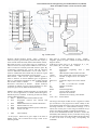
Fig.1 shows Total system. The System essentially consists of
following sections:
A. UDVACT module for receiving data from one network
and sending to other network . In case of absence of any
wireless network data is stored in the SD card of the
UDVACT.
B. Database system for storing the data - In this project
MySQL is used as database
C. Displaying of data on digital maps for local and remote
user For remote user , who is accessing the system through
internet , PHP is used for web page designing and Google map
are used for displaying location of vehicle. For local or remote
user authentication is required for accessing the data.
D. Displaying data on Smart phone – This is done using
design of Mobile application Location Finder.
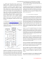
A. UDVACT module: It consists of GPS, GSM/GPRS,
WIFI, BLUETOOTH receivers. The receivers converts
concerned signal into UART format. Signals from UART
output port of GPS receiver are connected to UART0 input
port of microcontroller. Similarly signals from output UART
port of GSM/GPRS receiver, Wifi receiver, Bluetooth
261
receiver are applied to input UART1, UART2, UART3 ports
respectively of microcontroller. The signals from RS232,
USB, Ethernet port of UDVACT are connected to UART4,
USB, and Ethernet ports respectively of microcontroller.
LPC4357 Arm cortex M4 is used as microcontroller. Program
is written in the microcontroller to divert signals from one
wireless network or port to another wireless network or port
as summarized below network or port to another wireless
network or port as summarized in the Table I.
Table I: UDVACT INPUT - OUTPUT relationship
The choice of selection of input and output port is left to
User. The user selects the Input and Output port as per his
requirement. For vehicle tracking system, input is selected as
GPS and output is selected as GSM/GPRS or Wifi or
Bluetooth. If none of these networks are available , user have
option of storing data in the SD card for later viewing and
analysis.
GPS System is developed by U.S. Department of Defense
and can be used by Civilians and military personnel. The civil
signal SPS (Standard Position Service) can be used by public
while military signal PPS (precision Position Service) can be
used by authorized government agencies. Currently there are
28 C/A code is identification of satellite. GPS receiver is
capable of recognizing all C/A codes. Thus by shifting and
comparing each code with incoming satellite signal, complete
match will eventually occur. The correction point is used to
match and identify actual satellite [5].
Navigation message is a continuous stream of data transmitted
at 50bps. It consists of System clock and correction value, Its
own highly accurate orbital data (Ephemeris), Approximate
orbital data of all satellites (Almanac) and System health.
Navigation message consists of 25 frames per page. Each
frame consists of 1500 bits. Each frame consists of 5 sub
frames and there are 10 words per sub frame . Word number 1
and 2 consists of Telemetry word for synchronizing. Sub
frame 1 consists of satellite clock and health status. Sub frame
2 and 3 consists of Ephemeris and sub frame 4 and 5 consists
of almanac data [5].
DOP means Dilution of Precision - The accuracy with which
position can be determined using GPS depends on accuracy of
Pseudo range and geometrical configuration of satellites used.
Coordinate Systems- Geoids
is a reference surface for
measuring height. National and International map references
systems based on certain types of ellipsoids are called as
datum.
www.erpublication.org