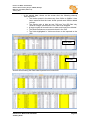
1
Partners for Water and Sanitation Note on project reports The following report has been prepared by Partners for Water and Sanitation in response to a project Terms of Reference. The content of the report is based on the opinion of the author(s) and does not necessarily represent the opinions of the wider PfWS partnership, or the project funders. Any extracts from the report should only be used with prior permission of the report author(s). Partners for Water and Sanitation, July 2010 Partners for Water and Sanitation Implementation of GIS / Asset Inventory in the Addis Ababa Water and Sewerage Authority (AAWSA) Ethiopia TECHNICAL REPORT Submitted by: Matthew Rose (Atkins Ltd, UK) Alex Nash (Atkins Ltd, UK) January 2010 Partners for Water and Sanitation GIS and Asset Inventory Project, AAWSA, Ethiopia Matt Rose, Alex Nash (Atkins Ltd) January 2010 Contents 1 Executive Summary ........................................................................................ 3 2 Introduction ..................................................................................................... 5 2.1 Terms of Reference........................................................................................... 5 2.2 The Addis Ababa Water and Sewerage Authority (AAWSA) Sewerage Service .............................................................................................................. 6 2.3 Current AAWSA GIS / Asset Inventory Status ................................................... 8 2.4 AAWSA Capacity .............................................................................................. 9 2.5 AAWSA Plans ................................................................................................. 10 3 Activities undertaken during the visit .......................................................... 10 3.1 Discussions ..................................................................................................... 10 3.2 Workshops ...................................................................................................... 11 3.3 Presentations .................................................................................................. 11 4 Outputs of the mission ................................................................................. 11 4.1 Information Management System in place ....................................................... 11 4.2 GIS system installed........................................................................................ 17 4.3 Bulk Conversion of CAD data to GIS format .................................................... 18 5 Next Steps ..................................................................................................... 19 5.1 Software updates and virus protection............................................................. 19 5.2 Splitting of CAD data to Branch level GIS format ............................................. 19 5.3 Installation of GIS in all branch offices ............................................................. 20 5.4 Complete formalised system for managing information ................................... 20 5.5 Linking of Sewerage and Water customer data ............................................... 20 5.6 Field surveys of network assets....................................................................... 21 5.7 Gaining basic GIS skills ................................................................................... 21 5.8 Development of Trunk Sewer Model ............................................................... 22 5.9 Exploration of options for advanced GIS database (server) and asset inventory front end........................................................................................... 23 6 Appendix A ± Terms of Reference ............................................................... 25 7 Appendix B ± Initial and Modified Programme for the visit ........................ 29 8 Appendix C - Converting CAD information to GIS format and using GIS.................................................................................................................. 36 Partners for Water and Sanitation January 2010 Page i Partners for Water and Sanitation GIS and Asset Inventory Project, AAWSA, Ethiopia Matt Rose, Alex Nash (Atkins Ltd) January 2010 8.1 Recommendation on GIS use within AAWSA .................................................. 36 8.2 Initial Setup ..................................................................................................... 36 8.3 Main Terminology ............................................................................................ 37 8.4 Importing Data................................................................................................. 38 8.4.1 AutoCAD ............................................................................................. 38 8.4.2 ArcView ............................................................................................... 39 8.4.3 SewerCAD ........................................................................................... 39 8.4.4 Raster Layers, Scanned Images (Google Maps).................................. 41 8.5 The Interface (GUI) ......................................................................................... 42 8.6 Viewing Data and Labelling ............................................................................. 44 8.7 Editing and Saving Data .................................................................................. 46 9 Appendix D - Using the hand-held GPS ....................................................... 47 10 Appendix E - Feedback ............................................................................... 60 Partners for Water and Sanitation January 2010 Page ii Partners for Water and Sanitation GIS and Asset Inventory Project, AAWSA, Ethiopia Matt Rose, Alex Nash (Atkins Ltd) January 2010 1 Executive Summary Partners for Water and Sanitation (PfWS) is a collaboration of government, private sector and NGO organisations dedicated to solving problems associated with providing access to water and sanitation in developing countries. The initial focus of the partnership is Africa. This report is a summary of the findings and recommendations from the visit to Ethiopia. This visit consisted of a series of discussions, workshops and training sessions with the Addis Ababa Water and Sewerage Authority (AAWSA). AAWSA requested PfWS assistance to build staff capacity in managing asset inventories and GIS. The first two days consisted of determining the most appropriate capacity building and training intervention, and the remainder of the visit (7 working days) was training, workshops and joint working. From the discussions and workshops we concluded that: x x x x The authority would benefit from the introduction of information management policies and procedures ± currently the absence of such procedures means that data is poorly managed, versions are not controlled, data owners and owners of individual data processes are not defined. While the authority has modern computer hardware (and is running one server with an oracle database), there is a generalised problem with software updates and particularly security (virus protection). This poses a severe risk to data and also represents a major loss of productivity for staff with infected computers. There is no functioning asset inventory or GIS. Authority sewer network data asset is stored in AutoCAD or SewerCAD, or hard copy, based on as built drawings or design drawings, mainly the latter. Good hard copies have been kept as have complete records of customer connections. Some sewer modelling is carried out at branch level. Network analysis activities are limited to designing new pipes prior to construction. No study of the overall impact of growth is carried out for the downstream system. This has serious implications for trunk sewer capacity in the long term. During the visit we were able to achieve the following outputs: x x x x x x Installation of GIS on the head office computer and I.T department computers. Development of management information diagrams and agreement of responsibilities, data flows, target completion times etc. Development of data collection forms. Training sewer on the new GIS and I.T staff in the installation of the software. Conversion of CAD data to GIS format and training staff in this process. Training in the use of the authority hand-help GPS in collecting sewer asset information. Partners for Water and Sanitation January 2010 Page 3 Partners for Water and Sanitation GIS and Asset Inventory Project, AAWSA, Ethiopia Matt Rose, Alex Nash (Atkins Ltd) January 2010 Recommendations: x x x x x x x x Implementation of an information management procedure for sewer assets information. We discussed this at length during the training and provided worked examples and developed a system for one of the branches (Nifas-silk Lafto branch). Correct file management systems and structure need to be put in place and enforced across all braches and the head office. We suggest a structure in this report. Software updates and virus protection should be implemented immediately under the auspices of the I.T department, who are most qualified to carry this out. We strong suggest a CDM USB broadband connection modem is purchased from ETC and used to check for anti-virus software updates for all machines regularly. The modem should also be used to download standard windows software updates and patches. An Information Technology department without hi-VSHHGDFFHVVWRWKHLQWHUQHW¶VLQIRUPDWLRQDQGUHVRXUFHV is simply not an option; it is a contradiction in terms1. Branch sewerage staff should endeavour to hold monthly meeting for data transfer and to share the growing body of GIS knowledge. Following these meetings, best practice could be agreed and a set of written procedures developed to assist technical staff and achieve consistency of approach. Implementation of GIS as the asset inventory (replacing CAD and SewerCAD as the primary repository of data). We worked on this during the mission and LQVWDOOHG 4XDQWXP *,6 RQ WKH KHDG RIILFH VHZHU HQJLQHHU¶V PDFKLQH FDUU\LQJ out this exercise with authority I.T staff so that these staff can roll the application out to the branches. An attempt was made to install it in one of the branches but defeated due to out of date software and virus ridden computers that are effectively unusable. The authority should embark on a process of updating asset information by carrying out asset surveys. This can be done as part of the day-to-day work at the branches. We agreed with the participants that a rate of 10 manholes plus 30 connection boxes per week per branch would be an attainable rate. If this is maintained, the authority will have a complete asset inventory within a year. Trunk lines should be prioritised. Staff GIS skills need to be developed as most staff have no experience with GIS software. This should be done using the tutorials provided in the software manual, by experimenting with the software, by using internet use groups for advice and by sharing knowledge within AAWSA. In addition to this, when a certain level of expertise has been achieved, AAWSA should employ local consultants who are skilled in the use of GIS to carry out a training workshop. A sewer model for the entire sewerage network (or trunk sewers at a minimum) should be developed. This should be done in conjunction with experienced sewer modellers (local or PfWS). This should be done when a minimum of asset data has been collected (100% of trunk lines). We estimate the authority should be ready for this training within 6 months, if the other recommendations above are implemented. 1 We will discuss ways of controlling internet usage and risks posed by the internet in the body of the report. Partners for Water and Sanitation January 2010 Page 4 Partners for Water and Sanitation GIS and Asset Inventory Project, AAWSA, Ethiopia Matt Rose, Alex Nash (Atkins Ltd) January 2010 2 Introduction Partners for Water and Sanitation is a not-for profit partnership that focuses on sharing technical expertise to build the capacity of the water and sanitation sector in Africa. Our vision is ... ... to be recognized as the leading provider of professional volunteer expertise to support the achievement of the Millennium Development Goal targets for Water and Sanitation in Africa. Our mission is ... ... to improve water and sanitation services and management in Africa. We achieve this through matching the demand for skills and advice from our in-country African partners with professionals from the UK water sector. Our UK partners then provide their staff on a voluntary basis to share knowledge and technical expertise to support a diverse range of projects. Our aim is to foster long term relationships with our partners to strengthen skills and performance of the water & sanitation sector to ultimately improve water management and sanitation.2 2.1 Terms of Reference The Terms of reference for the project stated the following justification for the PfWS intervention: ³3DUWQHUVIRU:DWHUDQG6DQLWDWLRQZLWKVXSSRUWIURP8.SDUWQHU¶V6RXWK:HVW:DWHU and Mouchel, has been offering technical advice and training to staff of the Addis Ababa Water and Sewerage Authority (AAWSA) in Ethiopia. This support has, to date, focused on asset databases, sewerage network design and options for effluent reuse. In March 2009, during a support visit by Trevor Nott of South West Water, AAWSA staff outlined a procedure for the collection and storage of asset data that will enable AAWSA to develop and maintain a quality data set for the future needs of Addis $EDED¶VVHZHUDJHQHWZRUN $YDLODEOHGDWDIURP$$:6$VXFKDVSODQVRIWKHFLW\¶VVHZHUOD\RXWSLSHJUDGLent and materials, depth, diameter and length for trunk sewers, types of manholes, connected population, etc.) is currently held in Sewer CAD, AutoCAD and spreadsheets, or archived in hard copy. 2 From the Partners for Water and Sanitation website: http://www.partnersforwater.org/ Partners for Water and Sanitation January 2010 Page 5 Partners for Water and Sanitation GIS and Asset Inventory Project, AAWSA, Ethiopia Matt Rose, Alex Nash (Atkins Ltd) January 2010 $$:6$¶V+HDG2IILFHDQGRSHUDWLRQDOEUDQFKRIILFHVLQ$GGis are responsible for the collection and management of liquid wastes. Although all the branch offices are providing sewerage disposal service by trucks, only 5 out of the total 8 branch offices are giving additional sewerage network system services. AAWSA would like to be able to store, access, retrieve and analyse data in such a way that it can be used in the design of new sewers to serve future developments, provide details to developers for connections and enable them to undertake survey/design works and costing. Other stakeholders, including Addis Ababa Roads Authority, the Ethiopian Telecommunications Corporations and Sub-City Administration also need access to WKLV GDWD 1HLWKHU WKH\ QRU $$:6$¶V EUDQFK RIILFHV DUH HOHFWURQLFDOO\ QHWZRUNHG WR $$:6$¶s Head Office. AAWSA is looking for new techniques to store, access, retrieve and analyse data ± HVSHFLDOO\ HQDEOLQJ WKH FXVWRPHU¶V VLGH RI WKH EXVLQHVV 0RUHRYHU WKH FXUUHQWO\ available data in Sewer CAD, AutoCAD and spreadsheets is held independently, with no system for importing / exporting data between the systems. $ UREXVW GDWDEDVH V\VWHP LQ $$:6$¶V +HDG 2IILFH DQG LQ WKH EUDQFK RIILFHV overseeing sewer networks, that can also be accessed by relevant stakeholders and gradually rolled-out to the remaining 3 branches, is considered of paramount importance. AAWSA staff are therefore seeking external expertise to help them set up and maintain such a database, either by building-on their existing knowledge and systems of GIS, AutoCAD and Sewer CAD, or by proposing alternative, user-friendly software that is mutually agreed as an appropriate solution.´ 2.2 The Addis Ababa Water and Sewerage Authority (AAWSA) Sewerage Service From a previous PfWS ToR: The conventional sewerage system of Addis Ababa city was introduced during the 1980s, as part of the 1st phase of the Addis Ababa City Sewerage Project (1979±1984). During 1984 to 1986 a further medium-scale sewerage line was constructed in the central and eastern parts of the city. Between these two projects, a total of about 100 km of sewerage has been constructed, with connections to the sewers starting from 1988. The sewerage system of Addis Ababa city covers less than 10% of the area of the city, or a population of approximately 150,000. There is one waste water treatment facility with limited capacity to serve the existing sewerage network. The sewerage Master Plan that was prepared for the city in June 2002 has not yet been implemented due to a lack of finances. Though a severe problem for the Authority is a lack of infrastructure, it also faces significant gaps in the capacity to operate and maintain the existing sewerage system. Partners for Water and Sanitation January 2010 Page 6 Partners for Water and Sanitation GIS and Asset Inventory Project, AAWSA, Ethiopia Matt Rose, Alex Nash (Atkins Ltd) January 2010 The major challenges facing Addis Ababa Water and Sewerage Authority (AAWSA) include: limited human resources and capacity in the management, operation and maintenance of the sewerage system; low levels of awareness from all parties such as decision makers, household & public connection beneficiaries, etc. the necessity of proper waste water handling; the low rates of sewerage service delivery and coverage compared with the increasing demands of the population; and low capacity to identify and implement alternative strategies and innovative ideas for improvement of the service. Delays have been experienced in implementing the proposals for a fully conventional sewerage system in line with the revised Sewerage Master Plan Study that was prepared in 2002 by the Netherlands Engineering Consultants (NEDECO) in association with other Netherlands consulting firms such as: DHV Consulting group and Association for Water Explorers (AUE). The delays in implementation were attributed by the lack of awareness of appropriate, alternative sewerage options to supplement development of a conventional sewer system. In addition to these, we can make the following comments: Like many developing utilities, AAWSA is probably in the low-service / low-revenue trap. The utility is publicly run and funded, and while officially they have a mandate to set tariffs, it is very likely that in practice it has little to no autonomy regarding tariff setting. We had a brief look at the billing system, where typical bills was water and sewerage are 30 ETB per month, charged exclusively based on consumption (so low consumption months resulted in bills of 3 ETB). This is about £1.50 per month. While this tariff might be appropriate for very poor households, given that the majority of houses connected to the water (and certainly sanitation networks) belong to the middle or upper classes, it represents a vast subsidy from the government revenues to the middle and upper classes. Sanitation is set at 5% of the water bill, regardless of the sanitation service offered. For those customers on the sewerage network, this represents a monthly cost of about 1.5 ETB (£0.08), which is the cost of a short ride on a public minibus. So the inconsistent situation exists where large villas, in which several new 4WDs may be parked, and which are connected to a well functioning sewer network, pay virtually nothing for their sewer service. Meanwhile, on-site sanitation services are not included in the price of the water bill. The authority does operate a number of vacuum trucks which were in good to excellent condition. Customers can request a vacuum truck service bill filling out a form in the branches. Prices for the service are fixed and also subsidised (below cost), but typically are around 69 ETB. Private operators charge a much higher, unsubsidised price. We were informed that all water connections are metered. Note also that the authority does not connect houses which do not have water connections to the sewer network (although, it is unlikely that there is much demand for this service). This means that all future sewer customers actually already have an account with the authority and are being charged for sanitation services. The authority does not bother to indicate in customer accounts in the billing system if each customer has a sewerage service or not, despite the fact that the billing system allows this. Partners for Water and Sanitation January 2010 Page 7 Partners for Water and Sanitation GIS and Asset Inventory Project, AAWSA, Ethiopia Matt Rose, Alex Nash (Atkins Ltd) January 2010 When a customer connects to the sewer network, the process is managed by the branches and the list of new customers is kept on excel spreadsheets in each branch. 1R FKDQJH LV PDGH WR WKH ELOOLQJ V\VWHP 7KH UHDVRQ JLYHQ ZDV WKDW ³WKH ZDWHU DQG VHZHUDJH GHSDUWPHQWV GR QRW FRPPXQLFDWH´ DOWhough this is more of a statement of fact rather than a reason. The excel spreadsheets also make no reference to the water contract number, by which customers are identified in the billing system. The customer name and address is used (free text fields), which will prove very difficult to connect information in the future about water and sewerage customers. 2.3 Current AAWSA GIS / Asset Inventory Status Currently AAWSA does not operate a GIS or Asset Inventory for asset management purposes. GIS software does exist and has been installed on some machines, although WKLVLVQRW\HWLQXVHDQGLVLQDQ\FDVHDQµXQRIILFLDO¶YHUVLRQRI$UF9LHZZKLFKKDV\HW to be proven. $³IL[HGDVVHWUHJLVWHU´)$5GRHVH[LVWIRUDFFRXQWLQJSXUSRVHVKRZHYHUZHZHUH unable to obtain a soft copy of this as the FAR is stored on an antiquated HP computer from which only hard copies can be extracted (we were told). The staff were uncertain when the accounting system was installed but it runs on an HP 3000 series computer which was first released in 1973 and has not been supported since 2006. It is likely that the system in use is over 20 years old. AAWSA therefore demonstrate a significant capacity to manage I.T assets and stretch IT asset lives, which is a very encouraging sign. The closest thing to a GIS or asset inventory operated by the authority is AutoCAD (again, an unofficial version). The SewerCAD plug-in has also been installed and the authority uses this for sewer modelling and sizing of extensions to the system. Participants in the workshop were particularly keen to develop sewer modelling skills. We were informed that AAWSA has been transcribing sewer asset data from as constructed diagrams into SewerCAD in order to the software as a modelling tool. A small fraction of the asset data has been transferred. In August 2009 Adolph Spitzer delivered training on Sewer Network design, which was greatly appreciated by AAWSA staff. This training covered standard design for new assets but did not cover sewer modelling using SewerCAD. The sewer files of AutoCAD contains around 3,000 point assets (manholes) and about the same number of link assets (pipes). We did not study the water asset files from AutoCAD but understand that the water network is also stored to a similar degree of detail. AutoCAD does not allow the storage of many shape attributes ± it is basically a program for drawing. SewerCAD allows additional attributes to be associated with the shapes, such as depth, diameter, slope, roughness etc. Partners for Water and Sanitation January 2010 Page 8 Partners for Water and Sanitation GIS and Asset Inventory Project, AAWSA, Ethiopia Matt Rose, Alex Nash (Atkins Ltd) January 2010 2.4 AAWSA Capacity As mentioned above, training on sewer modelling has been delivered by PfWS and was well received. Technical staff were keen to develop sewer modelling skills further. Many of the participants were versed in AutoCAD, and to a lesser extent, SewerCAD. Some modelling with SewerCAD has been carried out, and staff were keen to develop skills in this area. In theory technical staff carry out maximum pipe flow calculations for each branch ZKHQFRQVLGHULQJQHZFRQQHFWLRQV,QPRVWFDVHVWKH\PDNHDQ³H[SHUWMXGJHPHQW´ based on whether the pipe is visibly full at the lower manholes. None of the sewer department technical staff have experience using databases, asset inventories or GIS. The closest approximation to GIS they have used is SewerCAD, where some data from as built diagrams has been added to the CAD shapes. None of the staff we met had experience using a GPS. Some I.T department staff also took part in the training, and it transpired that the authority is in fact running an Oracle Database for the billing system. The I.T staff involved are well skilled in database administration, SQL, and have been running the billing system server since it was installed in 2001. They have also been running the finance system on an HP 3000 series computer which (we think) dates back to 1984-9. Although none of the branch computers are connected to the head office, all of the VHZHUDJHGHSDUWPHQWKHDGRIILFHFRPSXWHUVDUH³VWDQGDORQH´WKH,7GHSDUWPHQW does run a small LAN for the billing system. This LAN is carefully protected from viruses by a refusal to extend the LAN and server access to computers other than those required for billing. The finance system is a mainframe with 5 dedicated terminals and apparently no-one knows how to get data in a digital format out of it, let alone connect to it. AAWSA computers are currently at various states of the Microsoft Windows operating system. The installation of new software (such as GIS) usually requires up-to-date versions of windows. During the installation we repeatedly encountered errors due to missing files and out of date software on the computers. In addition to out-of-date software, the authority computers are dangerously exposed to viruses (in fact, many computers contain viruses). These viruses can damage or totally destroy data, but just as importantly, they cause a serious productivity loss. The viruses prevent users from using the computers by freezing them or requiring the computers to continually be re-started. Finally, but perhaps most importantly, no system of version control for data appears to be in place. Technical staff collect data that they need from various sources, depending on whom they know. No attempt appears to be made to control versions or data quality. This was acknowledged as a problem but we were not made aware of any plans to improve data management. The general view was that until the branches were connected to the head office, it would be impossible to work from a single version of CAD / SewerCAD. Partners for Water and Sanitation January 2010 Page 9 Partners for Water and Sanitation GIS and Asset Inventory Project, AAWSA, Ethiopia Matt Rose, Alex Nash (Atkins Ltd) January 2010 2.5 AAWSA Plans Some time into the mission we became aware that the I.T department of AAWSA have developed a terms of reference for a major upgrade of the authority I.T systems. The sewerage department staff were unaware of the scope of this upgrade, which includes a completely new billing system, asset inventory, GIS, branch connectivity, air conditioned server room etc. The total estimated cost is $1.5m. When this was discussed with Ato Gemechis the head of the sewerage department, there was some doubt that this tender would actually be let, due to the high cost. He was under the impression that it would not take place. However the I.T department staff informed us WKDWLWZRXOGEHOHW³LQDIHZZHHNV´ The tender, should it actually be implemented, will more or less make the current training and implementation efforts redundant, as a new system will come into place complete with technical training for the staff using it. In addition to the I.T infrastructure plans above, the authority has a number of sewer master plans, the most recent of which was completed in 2002. Work to expand the water supply capacity is underway being carried out by international consultants. 3 Activities undertaken during the visit 3.1 Discussions In order to plan the capacity building exercise, it was necessary to hold some discussions with AAWSA staff prior to developing the training programme. A fairly detailed programme was developed prior to our arrival in country (see Appendix B), over email and then finalised during a teleconference with Ato Gemechis (the owner of the Sewer Service core process). In the event, this programme was not adhered to, although most of the subjects detailed were covered. Site visits to the sewerage treatment plants were dropped, and field GPS training was included It became apparent that the most important aspect of the training would be determining how AAWSA manages information and attempting to improve this system. In order to GRWKLVVLJQLILFDQWWLPHZRXOGKDYHWREHVHWDVLGHWROHDUQ³KRZWKLQJVDUHGRQH´ before making suggestions and targeting training. This time was not really available, but discussions on business processes continued through the training, guiding the process. From the discussions we also understood that the participants main expectation was to learn how to convert CAD data to GIS and then how to carry out Sewer modelling. We repeatedly stressed that unless proper systems were put in place to manage the information they had, no useful modelling, asset inventory or GIS work would be able to be done. Partners for Water and Sanitation January 2010 Page 10 Partners for Water and Sanitation GIS and Asset Inventory Project, AAWSA, Ethiopia Matt Rose, Alex Nash (Atkins Ltd) January 2010 3.2 Workshops Most of the training took the foUPRI³ZRUNVKRSV´ZKHUHZHGLVFXVVHGZD\VRIGRLQJ this with AAWSA staff and tried to determine management improvements together. Process diagrams were drawn with the assistance of AAWSA staff. The GIS system was installed and some CAD data converted together, each trainee attempting to carry out the processes alone. GPS training was also carried out where staff learned to use the authority GPS devices and record information. Information gathering forms were developed and approved by the staff. We also held a workshop on the use of Google maps as a source of satellite photos for planning and mapping, and discussed how this could be brought into GIS and geo-referenced. The most recent aerial photography of Addis Ababa appeared to have been done for the master planning project in around 1994. 3.3 Presentations In addition to the workshops, we conducted a number of more formal and traditional training sessions, where presentations were delivered using Powerpoint to participants, covering database theory, information management principles, GIS basics, etc. These presentations were distributed in soft copy at the end of the mission. 4 Outputs of the mission 4.1 Information Management System in place After our discussions with the staff, and observations of the data contained in their computers, one of the main objectives of the visit was to agree a system to manage asset information in the future. We developed an information flow diagram for sewer asset information gathered at branch level, and discussed how this would flow to the head office and external parties. Note that this is based on incomplete information about how AAWSA does its business, so the flow diagram should be considered more of an example which AAWSA staff should develop to more correctly reflect the way their business processes work. This was repeatedly stressed however AAWSA staff did not have any major changes to make to the scheme when asked to verify it. Partners for Water and Sanitation January 2010 Page 11 Partners for Water and Sanitation GIS and Asset Inventory Project, AAWSA, Ethiopia Matt Rose, Alex Nash (Atkins Ltd) January 2010 After the general flow diagram was drawn, we encouraged the trainees to nominate individuals responsible for various data processes. This met with some resistance EHFDXVHWKHVWDIIDUHXVHGWRZRUNLQJ³DVDWHDP´ZKHUHUHVSRQVLELOLW\LVRQO\ delegated at senior levels. Junior staff did not appear to be willing to nominate WKHPVHOYHVDVEHLQJ³UHVSRQVLEOH´IRUDSDUWLFXODUUROHRUSURFHVV%\H[SODLQLQJWKDW responsibility for a data process was not the same thing as being senior to other staff, and did not mean that the nominee would actually have to do all of the work involved in that process, we were DEOHWRGHILQHWKHPRVWDSSURSULDWH³SURFHVVRZQHUV´IRUWKH various steps in information processing required to gather sewer asset data. We explained that the reason the flow diagram had to contain names was so that each process owner know whom they had to speak to, and relay information to, to ensure a smooth and timely flow of data. The resultant flow diagram for one of the branches is presented below: Partners for Water and Sanitation January 2010 Page 12 Partners for Water and Sanitation GIS and Asset Inventory Project, AAWSA, Ethiopia Matt Rose, Alex Nash (Atkins Ltd) January 2010 Partners for Water and Sanitation January 2010 Page 13 Partners for Water and Sanitation GIS and Asset Inventory Project, AAWSA, Ethiopia Matt Rose, Alex Nash (Atkins Ltd) January 2010 The information flow diagram also contains target response times for the various activities, based on what staff felt they could easily achieve. At first this was understood WREH³WKHWLPHLWWRRNWRGRWKHDFWLYLW\´KRZHYHUZHH[SODLQHGWKDWLWZDVWKH guaranteed latest time by which the activity would be done, taking into consideration the fact that the staff would have other concurrent tasks. A data gathering target was set to gather all AAWSA sewer network data over the course of a year. Given there are around 3,000 manholes in the CAD system, surveying these means gathering information on around 10 manholes per week, per branch (there are 8 branches). We noted that in addition to manhole data, branches should also survey connection boxes, which we estimated to occur at a rate of about 3 for every manhole. AAWSA staff agreed that it should be possible to collect up to 40 data points per day, and therefore the information gathering could take place on one day per week, per branch. This will allow the GPS devices (there are only 4 of them) to be shared between branches. In each branch there are three engineers trained in GPS survey as a result of our mission, so in theory, each engineer should only have to give up one day per three weeks to gather then data. To accompany the information flow diagram, we purchased stationary materials for each branch office including lever-arch folders, adhesive labels and transparent plastic envelopes so that hard copies could be managed carefully and all staff would have a central reference point for hard data flows, completed with hard copies of the process flow diagrams. The plastic sleeves should be marked with corresponding process steps as per the diagram. Clearly, both a demonstrated, sustained effort to collect sewerage network asset data and a function information management system should be a precondition for further PfWS assistance. The purpose of the capacity building is not only to increase individual skills, but also to strengthen the organisational capacity and effectiveness. Asset information should be collected in a standard format. There are existing forms for connection boxes and septic tank emptying, however these are lacking in some details required to develop and improve the asset data. During the course of the workshops improved survey cards were developed both for new connections and the surveying of existing assets. These are show below: Partners for Water and Sanitation January 2010 Page 14 Partners for Water and Sanitation GIS and Asset Inventory Project, AAWSA, Ethiopia Matt Rose, Alex Nash (Atkins Ltd) January 2010 New connection data: Manhole data: Partners for Water and Sanitation January 2010 Page 15 Partners for Water and Sanitation GIS and Asset Inventory Project, AAWSA, Ethiopia Matt Rose, Alex Nash (Atkins Ltd) January 2010 The data conversion process was also described in diagrammatic form, although a detailed description of how to convert CAD data to GIS is contained in Appendix C ± Converting CAD information to GIS format and using GIS. In general terms, the process is summarised below: Partners for Water and Sanitation January 2010 Page 16 Partners for Water and Sanitation GIS and Asset Inventory Project, AAWSA, Ethiopia Matt Rose, Alex Nash (Atkins Ltd) January 2010 A sample file structure was suggested to the trainees for storing asset inventory / GIS data: These forms and diagrams are all contained in soft copy on the disks issued to participants, to be used as examples to be developed by AAWSA as it refines its information gathering and management processes. 4.2 GIS system installed Quantum GIS (QGIS) was selected as an appropriate tool to install at AAWSA. This is because it is free software, regularly updated, simply to use and yet powerful enough for the purposes of the authority. It was also selected because it uses standard GIS forms such as shape (.shp) and ESRI files which are common across commercial GIS packages such as MapInfo and ArcVIEW. The authority had numerous copies of ³XQRIILFLDO´YHUVLRQVRI$UF9,(:KRZHYHULQVWDOOLQJWKHVHSUHVHQWHGVRPHSUREOHPV and we considered the use of software which had been tampered with to be a risky long-term strategy for holding important asset information. ,QDGGLWLRQWRLQVWDOOLQJ4*,6RQWKHKHDGRIILFHHQJLQHHU¶VFRPSXWHUZHDOVRLQVWDOOHG it on two of the I.T department machines with I.T staff, so that they should become experienced in rolling it out to the branches. We attempted to roll GIS out to one of the branches but failed to do so because the computers were both ridden with viruses and did not have the appropriate Microsoft updates installed. Without any internet access for ether the branch of the I.T department, there appeared to be no prospect of getting these updates installed. Partners for Water and Sanitation January 2010 Page 17 Partners for Water and Sanitation GIS and Asset Inventory Project, AAWSA, Ethiopia Matt Rose, Alex Nash (Atkins Ltd) January 2010 Workshops were held with the AAWSA staff to discuss the data types (fields) that should be held within the GIS to suit the AAWSA sewerage system. 4.3 Bulk Conversion of CAD data to GIS format Learning how to carry out the conversion of CAD data to GIS was one of the main objectives of the AAWSA trainees, however the skills required cannot realistically be acquired in a week, starting from the base of never having used a GIS, or Database, or SQL, before. Essentially, CAD contains drawings, which are images located in some defined geographical space. This information can be easily imported to GIS as an image in the correct location, however the attributes of the drawing (such as diameter, material, asset reference number etc) are not stored as part of the image. Rather, they are written as text beside the drawings in CAD. This text has to be associated with the drawings of the pipes by a complicated and manual programming process. For example, a program can be written to look for all text boxes near manhole objects, and to extract that text to use as the asset reference. Clearly, the user needs to know how to program the GIS, and also how to check for errors after the batch process has been done. These skills take a long time to accumulate. In the time allocated, the most effective course of action was for Matt to perform a bulk conversion of all the existing CAD data, using his programming skills to extract the best possible GIS basis from the data available, and that AAWSA staff gain the skills to update and maintain the new GIS database as new assets are created or surveys undertaken. AAWSA staff can import data to GIS from CAD (which is used for design) by using a more laborious manual process. This process is described in Appendix C ± Converting CAD information to GIS format and using GIS. Partners for Water and Sanitation January 2010 Page 18 Partners for Water and Sanitation GIS and Asset Inventory Project, AAWSA, Ethiopia Matt Rose, Alex Nash (Atkins Ltd) January 2010 5 Next Steps 5.1 Software updates and virus protection All computers should be brought up to date using the windows downloads which are freely available on the Microsoft website. Viruses should not be too difficult to control. Free anti-virus software is available and this should be applied. In order to apply this software and to get regular updates, the computers will need to be regularly connected to the internet. While it might be too costly to connect all computers to the internet, mobile broadband facilities now exist in Ethiopia, and if the I.T department were to purchase a mobile USB modem, then this device would be shared on a rotational basis for providing both windows and anti-virus software updates for each machine, once per month (for example). This is a high priority investment of about $400. If windows viruses continue to plague the authority, then consideration could be given to either purchasing commercial anti-virus software, or moving to a different platform (e.g. Linux). One machine in each branch could be converted to Linux and the GIS and data could be placed on this machine (where it would be safer). This would involve no cost, but some effort and skill. Priority: HIGH Responsibility: AAWSA (Atkins to send CD with anti-virus software as interim measure) Target completion date: April 2010 5.2 Splitting of CAD data to Branch level GIS format During the visit the available CAD data and some typical SewerCAD data was collected, this has been processed to provide the basis for the GIS data for the future. The GIS has been split into branch areas and has been provided on CD. Each branch should nominate an engineer responsible for reviewing and checking the bulk transfer of the CAD to GIS. This check should include the manhole numbering and arrangement of the sewer network. A layer has been provided showing potential issues identified during the bulk transfer process, this should be the starting point of the check. We have also provided other sample layers for Quantum GIS, and these should be reviewed and improved; x AAWSA Boundary and Branch Areas x Roads x Survey Grid x Street Layout Scans In addition, the raw CAD data used as the basis of the sewer records is included. Partners for Water and Sanitation January 2010 Page 19 Partners for Water and Sanitation GIS and Asset Inventory Project, AAWSA, Ethiopia Matt Rose, Alex Nash (Atkins Ltd) January 2010 Appendix C identifies many useful features of Quantum GIS and discusses the methodology for bringing in SewerCAD data into the Asset Inventory. Priority: HIGH Responsibility: Atkins Target completion date: March 2010 5.3 Installation of GIS in all branch offices Quantum GIS (QGIS) is a Geospatial Information System, the software is available for download at www.qgis.org, it is free to use and distribute under a GNU General Public Licence. We have provided the current LTS (Long Term Support) version of the VRIWZDUHRQ&'WR$$:6$YHUVLRQ³.RUH´ZKLFKVKRXOGEHLQVWDOOHGLQDOOWKH branch offices. A number of Microsoft Windows updates will also be required to allow the software to IXQFWLRQ,QDGGLWLRQVRPH³SOXJLQV´WR4*,6ZLOODOORZWKHSURJUDPPH WREHIXUWKHUUHILQHGWRVXLW$$:6$¶VSXUSRVHVDQGWKHVHVKRXOGEHLQVWDOOHGDQG configured at the same time. Further information can be found in the GIS Manual. Priority: HIGH Responsibility: AAWSA I.T Dept. Target completion date: April 2010 5.4 Complete formalised system for managing information The authority needs to complete the process stated during the workshops of developing information flow diagrams and assigning responsibilities and target process completion times. A separate diagram should be developed for each branch office in excel, printed out and distributed to staff at each branch and glued into the green folder provided. A copy should be provided to the head office. Priority: HIGH Responsibility: AAWSA Sewerage Dept. Target completion date: April 2010 5.5 Linking of Sewerage and Water customer data The authority should link water and sewerage customer information in the billing system. This is important for three reasons: 1) One day customers will be charged for their sewerage service, and the authority will need to know which customers are connected to the sewer in order to bill them correctly. Customers who are not connected will (and should) refuse to pay for sewer networks that they do not have access to, especially given they are already paying high prices for on-site sanitation services. Partners for Water and Sanitation January 2010 Page 20 Partners for Water and Sanitation GIS and Asset Inventory Project, AAWSA, Ethiopia Matt Rose, Alex Nash (Atkins Ltd) January 2010 2) The second reason is that by linking water and sewerage customer data, it will be possible to determine return to sewer flows based on metered volume consumption, and to estimate expected flows in sewer mains based on the number of customers upstream of a certain point. 3) The billing system is the obvious repository for all customer data, and it makes sense to store customer data only once, in one place. Where different customer information sources exist, they will quickly become inconsistent. Eventually, customer locations (GPS locations) should be stored in the billing system to facilitate better modelling and planning. In the short term, we propose the following steps be taken: 1) 8VHWKH³VHZHUVHUYLFH´WLFNER[LQWKHELOOLQJV\VWHPWRUHFRUGFXVWRPHUVZKR have a sewerage service. 2) 8VHWKH³FXVWRPHUQRWHV´ILHOGLQWKHELOOLQJV\VWHPWRQRWHWKHFRQQHFWLRQER[ reference that the customer is connected to (use the GIS unique asset ID). This information should be recorded in a standard format so that the data can be queried in the Oracle database at a later stage (e.g. the note field should FRQWDLQDUHFRUGVWDWLQJ³&%5HI&%;;;;;<<<<<´RQO\ 3) When customers order a vacuum truck service, this event should be recorded in WKH³FXVWRPHUFRQWDFW´SDUWRIWKHELOOLQJV\VWHP7KLVZLOOIDFLOLWDWHSODQQLQJIRU onsite sanitation demand, and perhaps help prioritise sewer expansions 4) Customer locations should be recorded in the notes field in a standard format HJ³;FRRUG;;;;;;<FRRUG<<<<<<´HYHU\WLPHDQHZFXVWRPHUFRQQHFWV to the water or sewerage network. This information will be available on the hard copies of the connection forms which are filled in by the crews who construct the connection box. Priority: MED Responsibility: AAWSA I.T and Billing departments / Sewerage dept. Target completion date: June 2010 5.6 Field surveys of network assets Sewer assets need to be surveyed on the basis of manholes, with the form provided in Section 4.1. We have suggested and target data collection rate of 10 manholes and 30 connection boxes per week, per branch. This should enable the authority to collect all asset data within a year. Priority should be given to trunk sewers, so that network modelling can start in July 2010. Priority: MEDIUM Responsibility: AAWSA Sewerage Dept. (Branch engineers) Target completion date: March 2011 5.7 Gaining basic GIS skills Following the initial training and workshops in the principles of GIS and developing and understanding in the data formats (for both field/record types and point/line/polygon data) it is essential that the AAWSA staff develop their GIS skills. To facilitate this there are a number of resources available. Partners for Water and Sanitation January 2010 Page 21 Partners for Water and Sanitation GIS and Asset Inventory Project, AAWSA, Ethiopia Matt Rose, Alex Nash (Atkins Ltd) January 2010 x x x x x We have provided a GIS Manual that outlines the basic routine tasks that AAWSA staff will need to carry out, it is recommended that this document is updated by AAWSA as new skills are learnt and circulated to other users to encourage skill development. This is particularly important with the users being located in remote branch offices. The QGIS manual provided on CD and located in C:/Program Files/Quantum GIS/docs [userguide.pdf] An additional QGIS user guide is provided on the CD which provides addition LQIRUPDWLRQUHODWLQJWRWKH³.RUH´UHOHDVHRIWKHVRIWZDUHZLWKZRUNHG examples and description of advance features [qgis-1.0.0_user_guide_en.pdf]. There are numerous Internet resources available, these can provide; o Searchable user forum at http://forum.qgis.org/ o Mailing Group at http://qgis.org/ o Additional software ± ³SOXJLQV´IRUSDUWLFXODUWDVNV o Software updates, including development versions of the software. Once a suitable level of GIS skills has been achieved, AAWSA should consider employing a local expert for a single days training, which would allow staff to raise questions relating to use of the GIS within AAWSA. The biggest step change with the learning of GIS skills would be the formation of a GIS User Group within AAWSA. This should be a small group which meets on a regular basis to increase the knowledge of GIS within AAWSA. Potential areas for discussion should be; x Sharing (and learning from) experiences x Developing User Guidance x Standardising the use of GIS x Planning for the future. The group should consist of Engineers from the Branch and Head office, representatives from the IT team and should be facilitated by a senior manager. Priority: MEDIUM Responsibility: AAWSA Sewerage Dept. (Branch engineers) Target completion date: June 2011 5.8 Development of Trunk Sewer Model The hydraulic modelling currently carried out is limited to the sizing of new pipes to make sure they are adequately sized for the proposed use. It was also reported to us that the modelling considers future scenarios for further upstream connections to the system and if this is being carried out it should be applauded. However, any consideration to the downstream trunk system is limited to surveying the connection point, and the modelling assumes that the trunk sewer has capacity. Partners for Water and Sanitation January 2010 Page 22 Partners for Water and Sanitation GIS and Asset Inventory Project, AAWSA, Ethiopia Matt Rose, Alex Nash (Atkins Ltd) January 2010 It is understood that the potential capacity of the trunk sewer is unknown, and with AAWSAs aspiration to significantly expand the sewer network in the future it is essential that the performance of the trunk sewer is understood. As data on the sewer system is collated into the Asset Repository (GIS), it will become possible to develop hydraulic models to allow analysis of the existing system and explore future scenarios. These scenarios can include, additional connections, increase in water usage, storm water inflow, infiltration and many other variables. The outputs from this modelling would allow AAWSA to develop a strategic plan to increase the capacity of the trunk sewer as the number of connections increase. The development could be carried out by AAWSA, or by external consultants. If AAWSA considered that it has the required skills in house the most suitable software (due to cost) would likely be SWMM5 by the US Environmental Protection Agency (EPA) which is available under a free GNU licence [http://www.epa.gov/ednnrmrl/models/swmm/index.htm]. Other software exists but would likely be prohibitive due to cost ($20,000+). The user guide to SWMM5 has been included in on the CD for information. Once sufficient Sewerage Asset data has been collected, a number of options exist to investigate the trunk sewer and PfWS would be able to assist in the investigation of these options. Priority: MEDIUM Responsibility: AAWSA Sewerage Dept. (head office engineer), with support from Atkins (Matt Rose). Target completion date: September 2010 5.9 Exploration of options for advanced GIS database (server) and asset inventory front end When the authority has installed a local area network and new servers, in addition to making the virus protection and software improvements discussed, consideration can be given to installing a fully multi-user GIS database, and an asset inventory front end. The GIS data is the asset inventoryKRZHYHUZKHQWKH*,6ILOHVUH³VWDQGDORQH´LH not in a server based database) they can only be accessed through the GIS software. In the future it will be useful to be able to access the same data through a database ³IURQWHQG´ Partners for Water and Sanitation January 2010 Page 23 Partners for Water and Sanitation GIS and Asset Inventory Project, AAWSA, Ethiopia Matt Rose, Alex Nash (Atkins Ltd) January 2010 Priority: LOW Responsibility: AAWSA I.T Dept with support from Atkins (Alex Nash) Target completion date: July 2010 Partners for Water and Sanitation January 2010 Page 24 Partners for Water and Sanitation GIS and Asset Inventory Project, AAWSA, Ethiopia Matt Rose, Alex Nash (Atkins Ltd) January 2010 6 Appendix A ± Terms of Reference Asset Management Database development: support to Addis Ababa Water and Sewerage Authority, Ethiopia Project Title 3DUWQHUV IRU :DWHU DQG 6DQLWDWLRQ ZLWK VXSSRUW IURP 8. SDUWQHU¶V 6RXWK :HVW Water and Mouchel, has been offering technical advice and training to staff of the Addis Ababa Water and Sewerage Authority (AAWSA) in Ethiopia. This support has, to date, focused on asset databases, sewerage network design and options for effluent reuse. In March 2009, during a support visit by Trevor Nott of South West Water, AAWSA staff outlined a procedure for the collection and storage of asset data that will enable AAWSA to develop and maintain a quality data set for the future needs of $GGLV$EDED¶VVHZHUDJHQHWZRUN $YDLODEOHGDWDIURP$$:6$VXFKDVSODQVRIWKHFLW\¶VVHZHUOD\RXWSLSHJUDGLHQW and materials, depth, diameter and length for trunk sewers, types of manholes, connected population, etc.) is currently held in Sewer CAD, AutoCAD and spreadsheets, or archived in hard copy. $$:6$¶V +HDG 2IILFH DQG RSHUDWLRQDO EUDQFK RIILFHV LQ $GGLV DUH UHVSRQVLEOH for the collection and management of liquid wastes. Although all the branch offices are providing sewerage disposal service by trucks, only 5 out of the total 8 branch offices are giving additional sewerage network system services. AAWSA would like to be able to store, access, retrieve and analyse data in such a way that it can be used in the design of new sewers to serve future developments, provide details to developers for connections and enable them to undertake survey/design works and costing. Justification Other stakeholders, including Addis Ababa Roads Authority, the Ethiopian Telecommunications Corporations and Sub-City Administration also need access WR WKLV GDWD 1HLWKHU WKH\ QRU $$:6$¶V EUDQFK RIILFHV DUH HOHFWURQLFDOO\ QHWZRUNHGWR$$:6$¶V+HDG2IILFH AAWSA is looking for new techniques to store, access, retrieve and analyse data ± HVSHFLDOO\ HQDEOLQJ WKH FXVWRPHU¶V VLGH RI WKH EXVLQHVV 0RUHRYHU WKH FXUUHQWO\ available data in Sewer CAD, AutoCAD and spreadsheets is held independently, with no system for importing / exporting data between the systems. $ UREXVW GDWDEDVH V\VWHP LQ $$:6$¶V +HDG 2IILFH DQG LQ WKH EUDQFK RIILFHV overseeing sewer networks, that can also be accessed by relevant stakeholders and gradually rolled-out to the remaining 3 branches, is considered of paramount importance. AAWSA staff are therefore seeking external expertise to help them set up and maintain such a database, either by building-on their existing knowledge and systems of GIS, AutoCAD and Sewer CAD, or by proposing alternative, userfriendly software that is mutually agreed as an appropriate solution. Aims Objectives and This project aims to provide expert skills and knowledge to enable AAWSA staff to develop an effective, robust and workable centralised asset management database that can be accessed by all relevant users, including operational branch Partners for Water and Sanitation January 2010 Page 25 Partners for Water and Sanitation GIS and Asset Inventory Project, AAWSA, Ethiopia Matt Rose, Alex Nash (Atkins Ltd) January 2010 offices. x x x x Deliverables x x x To achieve the deliverables, the following main activities are anticipated (with due reference to the report from the earlier support visit, prepared by Trevor Nott of South West Water ± available on request);: Share experiences in developing an asset management database; Conduct practical training to AAWSA staff in sewerage network asset database management, including software applications, building on earlier training in GIS, AutoCAD & Sewer CAD carried out with AAWSA. Help AAWSA staff develop procedures and techniques to set up a software-based asset database system, collect and store asset data that will enable them to build and maintain quality data sets to meet the current and future needs RIWKHFLW\¶VVHZHUDJHQHWZRUNDQG Provide ongoing technical input (through remote support) to guide AAWSA as they establish a software-based asset management database. Key deliverables in the support to AAWSA are anticipated to include: AAWSA staff equipped with basic principles and knowledge to set up and maintain a centralised asset management database, that can be accessed by all relevant users; AAWSA staff knowledgeable about basic procedures and techniques in the practical application of asset management databases appropriate for sewerage system development and management; $$:6$VWDII¶V,7VNLOOVHQKDQFHGLQXQGHUVWDQGLQJWKHPHWKRGVDQG procedures for uploading data to/from AutoCAD and Sewer CAD, export this to/from GIS and other user-friendly software, and to maintain a well-functioning system. AAWSA is to be the designated owner of the asset database, having full control over data entry. This is necessary to ensure consistency of asset registration (for new assets) and controlled amendments to the database. This support will help AAWSA develop an appropriate asset management database, centrally controlled by AAWSA, accessible and used by AAWSA staff at the Head Office, in its 5 branch offices, by other appropriate stakeholders and eventually in the remaining 3 branch offices. Impact Such a system can help AAWSA perform its responsibilities in managing, maintaining and improving the sewerage network in Addis Ababa with greater effectiveness and efficiency. The purpose of Partners for Water and Sanitation support is to build the knowledge and capacity of core staff within AAWSA who are responsible for existing asset data management, as they develop a functioning and appropriate asset management database. Scope x x The support will focus on the development of an enhanced database and records. It will include: training staff in software applications ± either on GIS or relevant userfriendly software, that could be used for a sewerage network database, and remote support in helping establish the software-based asset database. The UK partner can propose, in consultation with AAWSA staff, a user-friendly asset management database software system, based on personal experience in the field. Partners for Water and Sanitation January 2010 Page 26 Partners for Water and Sanitation GIS and Asset Inventory Project, AAWSA, Ethiopia Matt Rose, Alex Nash (Atkins Ltd) January 2010 The lead contact within AAWSA will be Ato Gemechis Tilahun, Process Owner of the Sewerage Service Core Process. He will be supported by Eng. Wondimu Tekle, the Deputy General Manager (Technical) and Ato Zereu Girmay of AAWSA. Ato Tesfaye Woredie from the Sewer Network System Unit will be available to assist with specific technical matters. The Partners for Water and Sanitation UK expert will hold a teleconference discussion with AAWSA staff and other relevant stakeholders in advance of the visit, to discuss how best to make the training and support visit effective. This will be supported with an exchange of proposals and information in advance of the visit. Organisation and methodology Ato Gemechis of the Sewerage Service Core Process will assign a team of focal persons within AAWSA to take the support forward. The Partners for Water and Sanitation UK expert will train 3 people from the Head Office and 2 people from each of the 5 branch offices, making a total of up to 15 people. The training will be based on relevant computer-aided software, identified as such in earlier communications. The UK expert will also provide ongoing remote support, following the visit and formal training sessions. x x Milestone plan A 2-week support visit is proposed to take place in mid November 2009. Actual dates are subject to availability of suitable UK expertise and can be negotiated to suit all parties concerned. It is hoped however that the training will take place during 2009. The visit will include: $GD\¶VSUHSDUDWRU\GLVFXVVLRQVZLWK$$:6$VWDIIDQGRWKHUNH\ stakeholders; Up to 10 days of half-day training sessions in the application of software based sewerage system database management. This will allow trainees to receive ½ days of formal training and allow ½ days for coaching / working through practical on-the-job exercises. A draft report is to be prepared within 4 weeks of the support visit ± for comment by AAWSA and key stakeholders. A final report is to be prepared within 4 weeks of receipt of feedback from AAWSA and other key stakeholders. Ongoing remote support to AAWSA staff is anticipated, following-up on advice given and actions agreed during the training visit. It is anticipated that this support can be carried out by one expert with relevant skills and experience in asset database development, applications and management (ideally in relation to sewerage systems). If considered appropriate, a team of two people with complimentary skills can be considered for carrying out the support. Input from the Partners for Water and Sanitation UK expert(s) is expected to comprise the following inputs (excluding travel time): Resource estimate x x x x x Initial support: 2 days preparation in the UK Up to 13 days in Ethiopia for training* (including a weekend); 3 days for writing the draft report 2 days for writing the final report 4 days for ongoing remote support Partners for Water and Sanitation January 2010 Page 27 Partners for Water and Sanitation GIS and Asset Inventory Project, AAWSA, Ethiopia Matt Rose, Alex Nash (Atkins Ltd) January 2010 *The timing required to deliver formal training sessions and support coaching will be identified and agreed through negotiation between AAWSA and the UK expert(s), considering the range of training sessions offered and relevance to $$:6$¶VFLUFXPVWDQFHV Further support may be likely, but this is subject to discussion and agreement between those concerned. Dependencies Timely feedback on reports issued and effective communication with AAWSA will be crucial to ensure this work is carried out successfully and efficiently. This will be assisted by the Partners for Water and Sanitation Country Manager. Risk: Lack of information and documents on existing data management within AAWSA Issues/Risks Mitigation: The Country Manager will liaise with AAWSA staff to secure as much information as possible, in advance of the training. Risk: In-country health, safety and security. Mitigation: The Country Manager & UK Secretariat will work with the UK expert to undertake a thorough Health & Safety and Risk Assessment procedure prior to travel. The key contact in Ethiopia is the Partners for Water and Sanitation Country Manager, Ato Melkamu Jaleta. Communication Strategy Ato Gemechis Tilahun is the key contact for all support provided by and to AAWSA staff. The Deputy General Manager (Technical) of AAWSA will receive regular reports from him. Direct communication between the Partners for Water and Sanitation UK expert and Ato Gemechis Tilahun will be established by the Partners for Water and Sanitation Country Manager as appropriate, prior to the training visit to Ethiopia. Review Mechanism Approvals (as appropriate) Compiled by Date Project-specific review mechanisms are to be agreed to by the Partners for Water and Sanitation UK expert. A visit report will be prepared after the training visit in Ethiopia, reporting against the visit objectives and making suitable UHFRPPHQGDWLRQV,QDGGLWLRQWKH&RXQWU\0DQDJHUZLOOIHHGLQWRWKH6HFUHWDULDW¶V quarterly reports on project progress, for submission to the Steering Group. On completion of the project, the Partners for Water and Sanitation UK expert may be required to help produce a final project report, detailing the project outcomes and impacts. Rebecca Scott, Partners for Water and Sanitation Project Manager, UK Secretariat Eng. Wondimu Tekle, The Deputy General Manager (Technical) of AAWSA Melkamu Jaleta, Partners for Water and Sanitation Country Manager, Ethiopia Gemechis Tilahun, the Sewerage Service Core Process Owner of AAWSA th 12 October 2009 Partners for Water and Sanitation January 2010 Page 28 Partners for Water and Sanitation GIS and Asset Inventory Project, AAWSA, Ethiopia Matt Rose, Alex Nash (Atkins Ltd) January 2010 7 Appendix B ± Initial and Modified Programme for the visit Addis Ababa Water & Sewerage Authority and Partners for Water and Sanitation Asset Data Base Management Training and Technical Assistance Addis Ababa, Ethiopia 5th to 14th January, 2010 Day 1 & 2 (5th -‐ 6th January, 2010) Date Time Activities Day 1: (Tuesday th 5 January, 2010) Until 10:30 am 10:30 ± 12:30 The UK team will have rest in their hotel Melkamu , Tesfayesus and the UK team to discuss and refine the schedule of the following days LUNCH BREAK The PfWS team will conduct an introductory discussion with Ato Gemechis (Head of Sewerage Service Core process) The Partners for Water and Sanitation (PfWS) team will conduct introductory discussions with the top Management of AAWSA The PfWS team & Ato Gemechis will further refine the training & TA programme of the next 7 days PfWS team will finalise the preparation for WKHQH[WGD\¶VHYHQWV Registration 12:30 - 13:30 13:30 ± 14:30 14:30 -15:30 15:30 ± 16:30 16:30 -17:30 Day 2: (Wednes th day 6 January, 2010) 8:30 ± 9:00 9:00±9:30 9:30± 10:30 10:30 ± 11:00 11:00 - 11:30 11:30± 12:30 12:30 ± 13:30 13:30 - 15:30 3UHVHQWDWLRQRQWKH$::6$¶V$VVHW'DWD Base Status, future plan and on the so far PfWS assessments Discussions on the presentation and agree on the focuses of the following days Coffee / Tea Break Present/introduce/share experience on the possible options of Asset Data Base (ADB) Development and Management to AAWSA team Discussions to identify and agree on the best option and also put the way foreword WRWKH$$:6$¶V$'%GHY¶W0JP¶W LUNCH BREAK Practical Technical support in two of the offices (IT subprocess/Unit) demonstrations in two groups Visit to sewer technical team to observe CAD in practice. Partners for Water and Sanitation January 2010 Responsible person All PfWS team Facilitator(s) Melkamu Alex, Matthew, Melkamu Melkamu Gemechis Alex, Matthew, Melkamu Gemechis Alex, Matthew, Melkamu Gemechis Alex, Matthew, Gemechis and AAWSA AAWSA Ato Gemechis (AWSSA) Ato Melkamu Ato Gemechis (AWSSA) Alex & Matthew Alex / Matthew Melkamu AAWSA team Alex / Matthew Alex / Matt Ato Gemechis Page 29 Partners for Water and Sanitation GIS and Asset Inventory Project, AAWSA, Ethiopia Matt Rose, Alex Nash (Atkins Ltd) January 2010 Date Time Activities Responsible person 15:30 -16:00 16:00 ± 17:30 COFFEE / TEA BREAK Practical Technical support in two of the offices (IT sub- process/8QLW&RQW¶G Development of training presentations and discussions about the next few days Alex / Matthew Facilitator(s) Ato Gemechis Day 3 & 4: (8th -‐ 9th January, 2010) Date Day 3 (Thursday th 7 January 2010) Day 3: th (Friday 8 January, 2010) Time All Day 8:30 ± 9:00 9:00 - 10:00 10:00 ± 10:30 10:30 ± 11:00 11:00 ± 12:00 12:00 - 12:30 12:30 - 13:30 13:30 - 15:30 Activities Development of Training presentations, investigation of software options on internet. Testing of software Registration Conduct training/present on the use of AutoCAD and/or Sewer CAD for the sewerage network asset database management Presentation of the revised agenda for the week training Discussions on the use of AutoCAD and/or Sewer CAD for Sewerage ADB Module 1: Information Management Responsible person Alex / Matt Facilitator(s) AAWSA AAWSA Matthew Alex Matthew Alex Coffee / Tea Break Conduct training/present on how to develop and manage the sewerage network asset database by transferring the existing data that are in AutoCAD, Sewer CAD and Excel sheets Module 1: Information Management Discussions on the transferability of data and the compatibility of the existing systems to develop and manage user friendly sewerage network asset database Module 1: Information Management Practical Technical support in two of the offices (IT subprocess/Unit) -demonstrations in two groups on the use of CADs and other options for ADB development and Management Module 2: Data collection in the field 15:30 - 16:00 Partners for Water and Sanitation January 2010 Alex Matthew Alex Matthew LUNCH BREAK Alex / Matthew Ato Gemechis COFFEE / TEA BREAK Page 30 Partners for Water and Sanitation GIS and Asset Inventory Project, AAWSA, Ethiopia Matt Rose, Alex Nash (Atkins Ltd) January 2010 Date Day 4: (Saturday th 9 January, 2010) Time 16:30 ± 17:30 8:30 ± 9:00 9:00 - 10:00 10:00 ± 10:30 10:30 ± 11:00 11:00 ± 12:00 !2:00 ± 12:30 12:30 - 13:30 13:30 - 15:30 15:30 - 16:00 16:30 ± 17:30 19:00 Activities Practical Technical support in two of the offices (IT subSURFHVV8QLW &RQW¶G RQ Whe use of CADs and other options for ADB development and Management Module 2: Data collection in the field Registration Responsible person Alex / Matthew AAWSA 6KDUH 8. WHDP¶V RZQ experience of the GIS and review the capacity of the participants in employing in to WKH$$:6$¶V$'%V\VWHP Meet at head office and go to site for data collection training and use of GPS training Discuss on the GIS experience sharing On site exercise ± data collection and GPS training Matthew Matthew Facilitator(s) Ato Gemechis AAWSA Alex Alex Coffee / Tea Break Conduct training/present on the use of GIS for the sewerage network asset database management On site exercise ± data collection and GPS training Discussions on the use of GIS for Sewerage ADB On site exercise ± data collection and GPS training LUNCH BREAK Present/introduce procedures and techniques to set up a computer based asset data base system On site exercise ± data collection and GPS training Alex Matthew Coffee / Tea Break Present/introduce procedures and techniques to set up a computer based asset data base V\VWHP&RQW¶G Downloading and testing of GIS related software Alex Matthew Day 5 & 6: (11th -‐ 12th January, 2010) Date Day 5: (Monday Time 8:30 ± 9:00 Activities Registration Partners for Water and Sanitation January 2010 Responsible person AAWSA* Facilitator(s) AAWSA* Page 31 Partners for Water and Sanitation GIS and Asset Inventory Project, AAWSA, Ethiopia Matt Rose, Alex Nash (Atkins Ltd) January 2010 Date th 11 January, 2010) Time 9:00 - 10:30 10:30 ± 11:00 11:00 ± 12:30 12:30 - 13:30 13:30 - 15:30 15:30 - 16:00 16:30 ± 17:30 Day 6: (Tuesday th 12 January, 2010) 8:30 ± 9:00 9:00 - 10:30 10:30 ± 11:00 11:00 ± 12:30 12:30 - 13:30 Activities Conduct practical site demonstrations on how to collect the sewerage network connections asset data Module 3: Database principles Responsible person Matthew/Alex Facilitator(s) AAWSA* Coffee / Tea Break Practical site demonstrations &RQW¶G RQ how to collect and locate the sewerage network connections by splitting in to simple individual connections and a multi user Complex connection like that of Universities, Hospitals, etc. Module 4: GIS basics Alex / Matthew AAWSA* LUNCH BREAK Conduct practical office level demonstrations on how to store asset data of the sewerage network connections Attempt installation of GIS in IT networked computers Alex / Matt Ato Gemechis COFFEE / TEA BREAK Continue on the practical office level demonstrations on how to store asset data of the sewerage network connections to build and maintain quality data sets Attempt installation of GIS in IT networked computers Registration Alex / Matthew AAWSA* Exercise on hydraulic modelling software such as CAD for the design and analysis of sewerage Matthew so as to get ideas of the link between the design aspects and the asset data management (Optional**) Discussion about the data we should collect and data flows. AAWSA teams present their ³KRPHZRUN´ RQ GDWD IORZV owners and responsibilities Coffee / Tea Break Discuss on the hydraulic modelling software options Matthew Attempted installation of GIS on +HDG 2IILFH (QJLQHHU¶V PDFKLQH (learning session with all engineers) LUNCH BREAK Partners for Water and Sanitation January 2010 Ato Gemechis AAWSA* Alex Alex Page 32 Partners for Water and Sanitation GIS and Asset Inventory Project, AAWSA, Ethiopia Matt Rose, Alex Nash (Atkins Ltd) January 2010 Date Time 13:30 - 15:30 15:30 - 16:00 16:30 ± 17:30 Activities Responsible person High level Group Work Exercise WKDW HQKDQFH WKH $$:6$ VWDII¶V Matthew/Alex IT skill in understanding the methods and procedures for uploading data to/from AutoCAD and Sewer CAD as well as other software Continued attempts to install GIS on IT machines (successful). Investigation of billing system. Coffee / Tea Break High level Group Work Exercise WKDW HQKDQFH WKH $$:6$ VWDII¶V IT skill in understanding the methods and procedures for Matthew /Alex uploading data to/from AutoCAD and Sewer CAD as well as other VRIWZDUH&RQW¶G Visit to branch office to attempt installation of GIS (failed due to viruses and out of date software). Collection of branch data. Working on processing of branch CAD data into GIS format using manual scripting Facilitator(s) AAWSA* AAWSA* Day 7 & 8: (13th -‐ 14th January, 2010) Date Day 7: (Wednes th day 13 January, 2010) Time 8:30 ± 9:00 Activities Registration 9:00 - 10:30 Field visit to Kaliti Waste Water Treatment Plant or one of the $$:6$¶V EUDQFK RIILFH WR conduct on spot discussion as to how the asset data base system at head office will be linked to the treatment plant/branch offices for better feeding one another (Optional**) Presentation of new field data collection forms. Presentation of data flow diagram for validation by team. 10:30 ± 11:00 11:00 ± 12: 30 Responsible person AAWSA* Matthew/Alex Coffee / Tea Break )LHOGYLVLWFRQW¶GWR.DOLWL:DVWH Water Treatment Plant or one of WKH $$:6$¶V EUDQFK RIILFH WR Alex/Matthew conduct on spot discussion as to how the asset data base system at head office will be linked/networked to the treatment plant/branch offices for better feeding one another (Optional**) Practical exercise in data conversion from CAD to GIS on KHDG HQJLQHHU¶V PDFKLQH QRZ working) Partners for Water and Sanitation January 2010 Facilitator(s) AAWSA* AAWSA* AAWSA* Page 33 Partners for Water and Sanitation GIS and Asset Inventory Project, AAWSA, Ethiopia Matt Rose, Alex Nash (Atkins Ltd) January 2010 Date Time 12:30 - 13:30 13:30 - 15:30 15:30 - 16:00 16:30 ± 17:30 Day 8: (Thursda th y 14 January, 2010) 8:30 ± 9:00 9:00 - 10:00 10:00 ± 10:30 10:30 ± 11:00 11:00 ± 12:00 !2:00 ± 12:30 12:30 - 13:30 Activities Responsible person LUNCH BREAK Group Discussions: Having got Alex / Matt through with over a week UK WHDP¶V 7UDLQLQJ7$ VXSSRUW WKH $$:6$¶V WUDLQLQJ SDUWLFLSDQWV will discuss in two groups to review the existing challenges and opportunities of asset database system development and management and also identify actions to be taken. Continued workshop on data conversion and use of GIS on KHDGHQJLQHHU¶VPDFKLQH COFFEE / TEA BREAK *URXS GLVFXVVLRQV &RQW¶G): Alex / Matthew $$:6$¶V WUDLQLQJ SDUWLFLSDQWs will develop action plans that will lead AAWSA to efficient and effective asset database system development and management Training workshop on data conversion and visit to WaterAid offices with I.T staff to investigate anti-virus tools (because WaterAid has broadband internet whereas AAWSA I.T staff have no internet access). Purchasing of stationary materials for information management systems in the branches. Printing on labels and downloading of software etc. Registration AAWSA* $$:6$¶V WUDLQLQJ SDUWLFLSDQWV will present their review results Matthew and action plans towards building effective asset data base system Preparation of CDs with soft copies of materials and course certificates Discuss on the AAWSA training SDUWLFLSDQWV¶ IHHGEDFNV RI WKHLU Matthew review processes and action plan for next steps Sewer modelling presentation Coffee / Tea Break $$:6$¶V WUDLQHHV ZLOO FRQGXFW panel discussion to identify the $$:6$¶V future follow up support areas by Participants the UK team in areas asset database Finalisation of information flow diagram for one of the branches including tasks assigned to individuals and target response times for activities. Conduct training/TA support $$:6$¶V evaluation Participants As above LUNCH BREAK Partners for Water and Sanitation January 2010 Facilitator(s) Ato Gemechis Ato Gemechis AAWSA* Alex Alex Matthew/Alex Matthew/Alex/Tesfayesus Page 34 Partners for Water and Sanitation GIS and Asset Inventory Project, AAWSA, Ethiopia Matt Rose, Alex Nash (Atkins Ltd) January 2010 Date Time 13:30 - 15:30 15:30 - 16:00 16:30 ± 17:30 Activities Responsible person Conduct wrap up meeting with +HDG RI $$:6$¶V 6HZHUDJH Alex/Matthew/Tesfay Service Core Process (Ato esus Gemechis) Lunch Coffee / Tea Break Conduct wrap up meeting with top Management of AAWSA (with the GM, Ato Getachew Alex/Matthew/Tesfay Eshete and the Deputy GM, Eng. esus Wondimu Tekle) to agree on the way foreword. Presentation of certificates. Facilitator(s) Ato Gemechis Ato Gemechis * 7KH5HVSRQVLEOHSHUVRQ)DFLOLWDWRUVSHFLILHGDV³$$:6$´VKRXOGEHnominated to be the AAWSA¶V Sewerage Service Core process. ** Optional activities are provided to give more rooms for any changes or modifications. Partners for Water and Sanitation January 2010 Page 35 Partners for Water and Sanitation GIS and Asset Inventory Project, AAWSA, Ethiopia Matt Rose, Alex Nash (Atkins Ltd) January 2010 8 Appendix C - Converting CAD information to GIS format and using GIS This appendix provides information on specific tasks that may need to be carried out with Quantum GIS to suit Addis Ababa Water & Sewerage Authority GIS for Wastewater Network Assets. The basic tasks and areas for self learning are contained within the Quantum GIS (QGIS) manual which is included in the data CD, and available for download at www.qgis.org - (Quantum GIS main site, latest software, manuals, plugins etc) This website also provides many resources for further learning, additional tools, sample data, and a web forum with many tips / tricks for the use of QGIS provided in a searchable forum. 8.1 Recommendation on GIS use within AAWSA ,WLVUHFRPPHQGHGWKDW$$:6$LGHQWLI\NH\PHPEHUVRIVWDIIWR³FKDPSLRQ´WKHXVHRI the GIS and set up an iQWHUQDO ³XVHU JURXS´ ZKLFK FDQ GULYH IRUZDUG WKH XVH RI *,6 within the organisation. In addition, it is recommended that AAWSA develop a set of procedures for the implementation and use of the GIS. This Appendix may form the EDVLVRIWKHLQLWLDO³$$:6$*,6 3URFHGXUHVDQG8VHU0DQXDO´WRSURYLGHDOOXVHUVZLWK a document describing common tasks, and that the Manual that should be updated as the usage and knowledge of GIS expands within AAWSA. 8.2 Initial Setup On The first installation of Quantum GIS, the program will ask for the path to the GRASS installation. The setup of Quantum GIS proposed does not require GRASS to provide the functions AAWSA require. Click OK, and navigate to C:\Program Files\Quantum GIS\grass Select Choose Partners for Water and Sanitation January 2010 Page 36 Partners for Water and Sanitation GIS and Asset Inventory Project, AAWSA, Ethiopia Matt Rose, Alex Nash (Atkins Ltd) January 2010 This should prevent the message appearing when the program is subsequently launched. However, if Cancel is selected the program will operate correctly, but the message will appear on each launch. Note: GRASS is free software and does provide some additional functions. As knowledge increases these functions it should be investigated. 8.3 Main Terminology Project Ȃ (.qgs file) This is an overall workspace that holds the views, layout and symbology of the layers. It does not contain any data (all data is held on the associated Vector Layers). If an AutoCAD analogy is used this is the ³SDSHUVSDFH´ ZLWK DOO WKH ³PRGHOVSDFH´ GDWD KHOG RQ WKH associated Vector Layers. Many Project files can access a single data layer, meaning the Vector Layer only exists once providing a single data file with the Asset or Mapping data. Vector Layer Ȃ (.shp file) This file contains the data associated with either in Point, Polyline or Polygon objects. (Note: it is possible to mix objects types in a Layer, but this is not recommended). The data in Vector Layers is held in a spreadsheet type format (called Attribute Table), it is important to populate the data in the correct fields. Symbology ± This term refers to the how you want the data to display in the Project. It can refer to symbol styles (lines, points etc). The symbology is saved in the Project (Not on the Vector Layer). Partners for Water and Sanitation January 2010 Page 37 Partners for Water and Sanitation GIS and Asset Inventory Project, AAWSA, Ethiopia Matt Rose, Alex Nash (Atkins Ltd) January 2010 8.4 Importing Data GIS Systems use three types of object data. x Points x Lines x Polygons Before importing data consider which type of data you wish to convert, it is best practice to keHS D VLQJOH REMHFW W\SH RQ HDFK OD\HU LH GRQ¶W PL[ OLQH SRLQW SRO\JRQ objects) 8.4.1 AutoCAD In AutoCad 1) On the command line, enter WBLOCK 2) In the Write Block Dialog box, under source, click Objects 3) Under Base Point, select the base point for the block you wish to save [0,0]. 4) Under objects, select the select Objects button 5) Select all the objects to include in the WBLOCK (New Dxf File) 6) Press ENTER to return to the dialog box 7) Under Objects, select the Select Objects button 8) Under destination, in the file name box, enter the name for the WBLOCK 9) In the Location Box, enter the location you want to save the WBLOCK (new Dxf File) 10) Click OK to create the new DXF file. In QGIS 1) Used the DXF to Shape Converter PlugIn from the menu or Icon Partners for Water and Sanitation January 2010 Page 38 Partners for Water and Sanitation GIS and Asset Inventory Project, AAWSA, Ethiopia Matt Rose, Alex Nash (Atkins Ltd) January 2010 2) The following dialog box will open Select the DXF file that has been created, and enter the name and path of the Shape File (with reference to the recommendations for AAWSA file naming system/structure), Enter Polygon, Polyline or Point ± dependant on the type of data being imported. If you have text objects in the data you are importing, select Export Text Labels, and these will be converted into a separate layer. Note ± the text is an attribute within a point object. 8.4.2 ArcView ArcView files are directly inter changeable with QGIS, and can be open in either system 8.4.3 SewerCAD This process is unfinished, and needs further research as skills are gained in the use of Quantum GIS. To Populate the GIS with data from SewerCAD requires a number of complex steps using SewerCAD, Excel and QGIS. It is recommended that for small data sets the GIS is updated manually within QGIS. If bulk imports this procedure is practiced on a copy of the data until the routine is perfected, and repeatable. The Notes below should be treated as a guide to the process, which will need building upon as skills are gained in AAWSA. Export SewerCAD data in grid format, and export to Excel. x A separate Excel Tab should be populated with the data for Nodes, and another for Links. x In Excel, clean up the data and identify the records that are required to be updated within the GIS. The screenshot below shows the format of the sample data used. x When cleaning up the data it is important to consider: o Whether the data you wish to import is correct o The data in the spreadsheet has the same Asset References as those held in the GIS o Any data that is not required is deleted o The fields that are to be imported match the field type in the GIS. Partners for Water and Sanitation January 2010 Page 39 Partners for Water and Sanitation GIS and Asset Inventory Project, AAWSA, Ethiopia Matt Rose, Alex Nash (Atkins Ltd) January 2010 o In the sample data, shown on the screen shot, the following cleanup was carried out: The levels quoted in the data vary from 340m to 2400m it has been assumed that the lower levels quoted need 2000m added to them. 7KH 6HFWLRQ VL]H LV KHOG DV WH[W ³ PP´ WKH *,6 ILHOG RQO\ KROGVDQLQWHJHUWKHUHIRUHWKH³PP´KDVWREHGURSSed. A large number of records have no data, and have been deleted. The Node References must match those in the GIS. The fields highlighted in Yellow are those to be imported to the GIS. Node Data Link Data Screen Shot showing the Raw Data Exported from SewerCAD Partners for Water and Sanitation January 2010 Page 40 Partners for Water and Sanitation GIS and Asset Inventory Project, AAWSA, Ethiopia Matt Rose, Alex Nash (Atkins Ltd) January 2010 Screen Shot showing the cleaned up Data Exported from SewerCAD Save each of the Excel Tabs as a DBF file. This is possible in Excel 2003 (Save As, dbf4). It is not possible to save as dbf from Excel 2007. Dedicated converters are available to purchase, or it should be possible to convert Excel through ArcView. Three potential tools should be investigated to create the SewerCAD data in QGIS x Join Table in fTools ± Data Management x 'HOLPLQWRU7DEOH,PSRUWZDWFKIRUVHSDUDWRUV³´LQFRRUGLQDWHV x Table Manager ± QGIS Plugin Further Investigation is required, in the interim it is recommended that updates to the data is limited to Manual Inputs. 8.4.4 Raster Layers, Scanned Images (Google Maps) Raster Layers (scans, jpegs etc) can be imported as Layers into QGIS XVLQJWKH³JHRUHIHUHQFHU´SOXJLQ Before starting identify at least three points on the scanned map where the coordinates are known (get coords from CAD backgrounds). For example, major road junctions. To get the best possible match, choose three points which are to the extents of the scanned image. Open the scanned image, and add the three points with the coordinates. 6HOHFW³&UHDWHDQG/RDG´WR Partners for Water and Sanitation January 2010 Page 41 Partners for Water and Sanitation GIS and Asset Inventory Project, AAWSA, Ethiopia Matt Rose, Alex Nash (Atkins Ltd) January 2010 6HOHFW³&UHDWHDQG/RDG´WREULQJWKH image into the map. Note, move the layers (drag and drop) to order the view and bring the sewers to the top. 8.5 The Interface (GUI) See QGIS Manual, for general instructions with using Quantum GIS. One important area is ensuring that layers created, and the overall project is created with the correct coordinate system (UTM WGS84 Zone 37 Northern Hemisphere). 7KLVGRQHXVLQJ³6HWWLQJV´DQG³3URMHFW3URSHUWLHV´ Partners for Water and Sanitation January 2010 Page 42 Partners for Water and Sanitation GIS and Asset Inventory Project, AAWSA, Ethiopia Matt Rose, Alex Nash (Atkins Ltd) January 2010 6HOHFW³&RRUGLQDWH5HIHUHQFH6\VWHP´DQGFKRRVHWKHIROORZLQJ x Projected Coordinate System x Universal Traverse Mercator (UTM) x WGS84 Zone 37 North This can be entered as the following string. +proj=utm +zone=37 +ellps=WGS84 +datum=WGS84 +units=m +no_defs Partners for Water and Sanitation January 2010 Page 43 Partners for Water and Sanitation GIS and Asset Inventory Project, AAWSA, Ethiopia Matt Rose, Alex Nash (Atkins Ltd) January 2010 8.6 Viewing Data and Labelling Double Click on layer, or right click properties to enter the Layer Properties dialog Box. A full explanation of this Dialog Box is found in the Manual. To explore the possibilities of the Layer Properties, the following example will display the SEWER_LINES with the line with varying depending on the pipe size (PIPE_HEIGHT), will display the pipe size as text when zoomed in. Partners for Water and Sanitation January 2010 Page 44 Partners for Water and Sanitation GIS and Asset Inventory Project, AAWSA, Ethiopia Matt Rose, Alex Nash (Atkins Ltd) January 2010 Open Attribute Table Data can also be viewed (and edited) in the attribute table (data can be cut and pasted to excel or similar for analysis). Partners for Water and Sanitation January 2010 Page 45 Partners for Water and Sanitation GIS and Asset Inventory Project, AAWSA, Ethiopia Matt Rose, Alex Nash (Atkins Ltd) January 2010 8.7 Editing and Saving Data It is only possible to edit one layer at a time 1 Select Layer 2 2 Select Toggle Editing 3 Add or Move Objects 3 1 4 5 4 Select Identify Features Select Feature (sewer/manhole) 5 Edit Attribute Data 2 Toggle Editing to SAVE To Save any changes, you must toggle the editing OFF ± do this regularly to avoid losing any changes. Partners for Water and Sanitation January 2010 Page 46 Partners for Water and Sanitation GIS and Asset Inventory Project, AAWSA, Ethiopia Matt Rose, Alex Nash (Atkins Ltd) January 2010 9 Appendix D - Using the hand-held GPS The authority GPS devices can be used to obtain coordinates for assets which will allow the assets to be reliably located in the GIS or AutoCAD. The device is shown in the image below: This is the on/off button 7KH³SDJH´EXWWRQ moves between the pages of the GPS. The most useful page for surveying is the one show here Altitude is shown here. This is not very accurate X and Y coordinate accuracy is show here. This is the X coordinate This is the Y coordinate These are the grid units (UTM). Partners for Water and Sanitation January 2010 Page 47 Partners for Water and Sanitation GIS and Asset Inventory Project, AAWSA, Ethiopia Matt Rose, Alex Nash (Atkins Ltd) January 2010 To change the grid units you need to press the menu button here. The page menu pops up, but you need to press the menu button again to get to the main menu Partners for Water and Sanitation January 2010 Page 48 Partners for Water and Sanitation GIS and Asset Inventory Project, AAWSA, Ethiopia Matt Rose, Alex Nash (Atkins Ltd) January 2010 The main menu is a list of options. Use the round button in the middle here to select different items. Scroll down to ³VHWXS´ Partners for Water and Sanitation January 2010 Page 49 Partners for Water and Sanitation GIS and Asset Inventory Project, AAWSA, Ethiopia Matt Rose, Alex Nash (Atkins Ltd) January 2010 You will come to this page. Here, use the round centre button to move to the fourth tab called ³/RFDWLRQ´ <RXFDQ¶WVHH Location on the screen so you need to keep going to the right Then select the third tab called ³/RFDWLRQ´DQG press the enter button Partners for Water and Sanitation January 2010 Page 50 Partners for Water and Sanitation GIS and Asset Inventory Project, AAWSA, Ethiopia Matt Rose, Alex Nash (Atkins Ltd) January 2010 This is the ³/RFDWLRQ´WDE When you get here, scroll down to the first box ³/RFDWLRQ)RUPDW´ When you have selected this box, SUHVVWKH³(QWHU´ button Partners for Water and Sanitation January 2010 Page 51 Partners for Water and Sanitation GIS and Asset Inventory Project, AAWSA, Ethiopia Matt Rose, Alex Nash (Atkins Ltd) January 2010 A list of options will pop up. Choose the Units you want. AAWSA AutoCAD maps appear to be in UTM UPS units. When you have selected it, press enter. Then use the ³4XLW´EXWWRQWR go back to the main pages. Partners for Water and Sanitation January 2010 Page 52 Partners for Water and Sanitation GIS and Asset Inventory Project, AAWSA, Ethiopia Matt Rose, Alex Nash (Atkins Ltd) January 2010 7RILQGDORFDWLRQXVLQJLWV;DQG<FRRUGLQDWHV\RXQHHGWRHGLWD³ZD\SRLQW´DQGWKHQ ³JRWR´WKDWZD\SRLQW7RGRWKLVGRWKHIROORZLQJVWHSV Press tKH³JRWR´ button. The select the RSWLRQ³ZD\SRLQW´ Press enter Partners for Water and Sanitation January 2010 Page 53 Partners for Water and Sanitation GIS and Asset Inventory Project, AAWSA, Ethiopia Matt Rose, Alex Nash (Atkins Ltd) January 2010 The top box in this screen allows you to search for a waypoint. You Can enter any numbers or letters and a list of stored waypoints will appear below Select any waypoint ± it GRHVQ¶WPDWWHU what one. Press enter Partners for Water and Sanitation January 2010 Page 54 Partners for Water and Sanitation GIS and Asset Inventory Project, AAWSA, Ethiopia Matt Rose, Alex Nash (Atkins Ltd) January 2010 Then press the page button until you get to the ³DFWLYHJRWR´ page. Here, select the active waypoint and press enter. Partners for Water and Sanitation January 2010 Page 55 Partners for Water and Sanitation GIS and Asset Inventory Project, AAWSA, Ethiopia Matt Rose, Alex Nash (Atkins Ltd) January 2010 Then press the page button until you get to the ³DFWLYHJRWR´ page. Here, select the active waypoint and press enter. We need to edit this waypoint to put in the coordinates that we want to go to Partners for Water and Sanitation January 2010 Page 56 Partners for Water and Sanitation GIS and Asset Inventory Project, AAWSA, Ethiopia Matt Rose, Alex Nash (Atkins Ltd) January 2010 After you press WKH³HQWHU´EXWWRQ on the waypoint, you can edit it. Use the round button to scroll down to the ³ORFDWLRQ´ER[ which is here. Press enter when you are on this box, and then use the round button to select each number and change it to the X and Y coordinate that you are trying to find. Partners for Water and Sanitation January 2010 Page 57 Partners for Water and Sanitation GIS and Asset Inventory Project, AAWSA, Ethiopia Matt Rose, Alex Nash (Atkins Ltd) January 2010 Editing the waypoint looks like this. Use the round button in the middle to change the numbers to the ones you want. When you are done, press ³HQWHU´WRJHWRXW of the editing mode. Finally, press the page button until you come to the compass page which should now guide you to your ³DFWLYHJRWR´ Partners for Water and Sanitation January 2010 Page 58 Partners for Water and Sanitation GIS and Asset Inventory Project, AAWSA, Ethiopia Matt Rose, Alex Nash (Atkins Ltd) January 2010 Navigating to \RXU³DFWLYHJRWR´ can be done using the page show. Remember: The compass only works when you are moving Partners for Water and Sanitation January 2010 Page 59 Partners for Water and Sanitation GIS and Asset Inventory Project, AAWSA, Ethiopia Matt Rose, Alex Nash (Atkins Ltd) January 2010 10 Appendix E - Feedback Response s Score (1-6) Regarding relevance of course content 5.5 What I learnt in this course will help me improve my 12 performance? 5.5 Material and issues were current and worthwhile 12 5.16 The course was relevant to my needs 12 5.83 Regarding the quality of course design 5.291667 The structure and institutional modes of the course 12 encouraged learning 5.66 The course objectives were fully addressed 12 5.16 The course actively and effectively engaged me through12 out 5.58 The duration of the course was just right 12 4.5 Overall this was a high quality course 12 5.41 Relative to other training that I have attended I would rank 12 this course as one of the best 5.41 Regarding the quality of the instructors 5.8125 The instructors encouraged and responded will to 12 questions 5.91 The instructors have knowledge in the course content 12 5.66 The instructors treated participants with respect 12 5.91 The instructors were well prepared and organised 12 5.75 The pace of instruction was just right 12 5.75 Comments Please comment on any of the statements in the previous sections, particularly those you disagree with.( e.g. if the duration of the course was right, was it too short or too long?) x The course content is large but the time given was short and also the training room is not comfortable x 7KHGXUDWLRQRIWKHFRXUVHLVYHU\VKRUWDQGZHGLGQ¶WJHWWLPHWRUHODWHGWKHRU\ with practice x We need a continuous training on the subject x Just a right time x It is too short Where there any aspects of the course that you think should be improved? x Keep its continuity x We need to improve our knowledge in sewer modelling and GIS data processing and how to use GPS a data entry in the system x The application GIS is the most important for our work in our organization, so it should be given due attention a lot time to deal with it x )RUVRPHWLPHVLQWKHWUDLQLQJGD\VWKHUHZDVDGHOD\DQGGLGQ¶WVWDUWRXU training course on as per the schedule. Be punctual. x I expect your next trainings would be on software like SewerCad Which parts of the course did you find useful? Partners for Water and Sanitation January 2010 Page 60 Partners for Water and Sanitation GIS and Asset Inventory Project, AAWSA, Ethiopia Matt Rose, Alex Nash (Atkins Ltd) January 2010 x All parts of the course were useful. But the best one is the method of solving the maintenance of the broken pipe x The database and GIS relationship was useful x Downloading geographical maps form Google maps to get recent maps of the city x How to put assets data the we found from CAD into GIS x How to transfer shape files x How to manage our data x Principle of database General comments x We need more capacity building efforts and keep on giving such kind of trainings x The course was very essential and it was given at the right time x The course was dealing mostly on sewer and sanitation. It would be best it it includes water aspects. x We would like to thank partners for water and sanitation Appendix F: List of Participants for Assets Database and Management Training 1. Shorit Zewde 2. Selamawit Teshale 3. Taressa Workneh 4. Alemayehu Tadesse 5. Ephrem Gebremeskel 6. Habtom Gidey 7. Daniel Assefa 8. Habtamu Duguma 9. Zelalem Ketema 10. Nigussu Gebreegziabher 11. Rekik Tsegaye 12. Yemisirach Bishaw 13. Henok Girma 14. Eneyew Tamiru 15. Biruktawit Kassahun 16. Henok Melka Partners for Water and Sanitation January 2010 Page 61