1
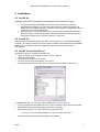
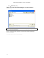
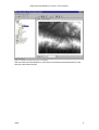
ARIS ASCII Grid Reader for ArcGIS
User's Manual
16 February 2010
ARIS B.V.
http://www.aris.nl/
ARIS ASCII Grid Reader for ArcGIS - User's Manual
Table of contents
1.
Introduction ......................................................................................................................3
2.
Installation........................................................................................................................4
2.1
2.2
2.3
2.4
ArcGIS 8.x ....................................................................................................................4
ArcGIS 9.2....................................................................................................................4
ArcGIS 9.3 and ArcGIS 9.3.1 .......................................................................................4
De-installation...............................................................................................................5
3.
Registration......................................................................................................................6
4.
Using ASCII Grid files ......................................................................................................7
5.
Projections .......................................................................................................................9
6.
FAQ................................................................................................................................10
7.
History............................................................................................................................12
8.
The ESRI ASCII Grid Format.........................................................................................13
Appendix A. License Agreement ..............................................................................................14
ARIS
2
ARIS ASCII Grid Reader for ArcGIS - User's Manual
1. Introduction
The ARIS ASCII Grid Reader for ArcGIS makes it possible to view files in the ESRI ASCII
Grid format in ArcCatalog and ArcMap without having to convert those files.
Spatial models, which have been written outside of standard GIS applications (i.e. written in
C/C++ or Fortran), often use the ASCII Grid format for storing intermediate and / or final
results. In order to view this data in ArcMap, it is necessary to use ArcToolbox to perform a
conversion from ASCII Grid to a native ESRI GRID. This ESRI GRID can then be viewed in
ArcMap. Another option would be to use ArcObjects to perform the conversion in the
background, and show the result.
ARIS now has a solution, which makes it possible to preview ASCII Grids directly and without
conversion in ArcCatalog, and to add them to ArcMap. All the default raster operations in
ArcMap (for example the Raster Calculator) can be applied to the ASCII Grid.
Using ASCII Grid files directly also improves overall performance (compared to a background
conversion). Initially there is a time gain of about 50% (several seconds for a raster of
500.000 cells), if the same file is used again the gain is even bigger (over 95%). Also, no
temporary files are created, whereas a conversion always produces a new file on the hard
disk, which need to be cleaned up after some time.
Floating-point and integer type ASCII Grids are recognized automatically, whereas
ArcToolbox creates a floating-point grid by default, unless explicitly specified by the user. An
important difference between floating-point and integer type rasters is that a Unique Value
Classification is available for integer rasters.
The ARIS ASCII Grid Reader is implemented as a dll which, once placed in the correct
ArcGIS directory, is used to identify files in the ASCII Grid format.
The ARIS ASCII Grid Reader can be used with any version of ArcGIS (ArcView, ArcEditor
and ArcInfo, version 8.0 or higher).
ARIS
3
ARIS ASCII Grid Reader for ArcGIS - User's Manual
2. Installation
2.1 ArcGIS 8.x
Installation of the ASCII Grid Reader is accomplished with the following two steps:
1. The automatic setup (arisasciigrid.exe) needs to be executed by a user with
administrative privileges. The setup procedure checks if ArcGIS is installed, and
determines the installation directory. Any necessary changes in configuration files for
ArcGIS are carried out automatically.
2. Using ArcGIS 8.x, other users who want to use the ASCII Grid Reader will need to
finish the setup procedure by clicking on the Start button and choosing Programs |
ARIS ASCII Grid Reader for ArcGIS | Install for current user.
2.2 ArcGIS 9.2
The automatic setup (arisasciigrid.exe) needs to be executed by a user with administrative
privileges. The setup procedure checks if ArcGIS is installed, and determines the installation
directory. Any necessary changes in configuration files for ArcGIS are carried out
automatically.
2.3 ArcGIS 9.3 and ArcGIS 9.3.1
In ArcGIS 9.3 and 9.3.1 disable the default *.asc:
• Open in ArcMap or ArcCatalog the menu "Tools" / "Options"
• Select the tab "Raster".
• On this tab click button "File Formats".
• Uncheck the "Arc/Info ASCII GRID *.asc" format.
• Currently this will have no effect: This is a bug being fixed by ESRI in ArcGIS 10
To disable the default *.asc format, until the ESRI bug fix, do the following:
• In the <program files>\ArcGIS\bin directory: make a backup copy of RasterFormats.dat
• Edit RasterFormats.dat (with Notepad or any other text editor).
• Remove the reference to "*.asc" this is the row that looks like:
<e on="y" nm="Arc/Info ASCII GRID" ex="*.asc" et="ASC" at="0x2f" />
•
Save RasterFormats.dat and start ArcMap or ArcCatalog.
ARIS
4
ARIS ASCII Grid Reader for ArcGIS - User's Manual
2.4 De-installation
De-installation of the ASCII Grid Reader is straightforward, but make sure you exit all ArcGIS
applications before de-installing the ASCII Grid Reader.
ARIS
5
ARIS ASCII Grid Reader for ArcGIS - User's Manual
3. Registration
The distributed version of the ASCII Grid Reader is a fully functional version, except that there
is a reminder message shown, each time you open an ASCII Grid file.
Pressing the Buy Now! button will take you to our online store, where you can order this
product. Note that you will need the hardware fingerprint of the computer where you want to
install the tool, shown in the dialog below (appears when you press Enter Key). After you
complete your purchase, a personal registration key will be sent to you by email. Please store
this key in a safe place.
Pressing the Enter Key button will present you with the following dialog, where you must enter
your name and the registration key.
Once you have entered a valid registration key, press OK. This key will be stored on your pc.
ARIS
6
ARIS ASCII Grid Reader for ArcGIS - User's Manual
4. Using ASCII Grid files
After the setup procedure has finished, ASCII Grid files can be used in ArcMap and
ArcCatalog with the standard functions: In ArcMap, use the Add Data button to add an ASCII
Grid to the map:
Note: Only ASCII Grid files that have a file extension *.asc, *.grd, *.agr or *.aig can be used.
Other file extensions will be ignored.
Likewise, all standard function, such as the Raster Calculator and other Spatial Analyst
functions are available.
ArcCatalog recognizes ASCII Grids automatically.
ARIS
7
ARIS ASCII Grid Reader for ArcGIS - User's Manual
Figure 1. Preview of an ASCII Grid shown in ArcCatalog.
With the ARIS ASCII Grid Reader an ASCII Grid is automatically stretched between the low
and high values within the grid.
ARIS
8
ARIS ASCII Grid Reader for ArcGIS - User's Manual
5. Projections
Projection information is passed to ArcMap and ArcCatalog, if a projection file accompanies
the ASCII grid. Projection files should have the same name as the ASCII file, but with a .prj
extension. For instance, if the ASCII grid is named myraster.asc, the projection file should be
called myraster.prj. Both files should be placed in the same folder.
Even if all your data uses the same projection, you can still add a projection file to the
asciigrid, since this will stop ArcMap from warning you that your raster doesn’t contain
projection information.
The easiest way to find a valid projection file is to browse the ArcGIS installation folder, in the
subfolder Coordinate Systems. For instance, the projection file for WGS 1984 can be found in
C:\Program Files\ArcGIS\Coordinate Systems\Geographic Coordinate Systems\World. Just
copy this file to the folder containing your ASCII grid and rename the copy to match the base
name of the grid.
ARIS
9
ARIS ASCII Grid Reader for ArcGIS - User's Manual
6. FAQ
Q:
A:
Only “Administrator” can see ASCII Grids.
Log in to your ordinary user account. Then, from the Start Menu, choose Programs >
ARIS ASCII Grid Reader > Install for current user.
Q:
I installed the ASCII Grid Reader, but ArcMap and ArcCatalog still don’t see ASCII
Grids.
There can be several reasons for ArcGIS not to recognize ASCII Grids, some of
which are:
- You have Windows NT 4.0: There is an issue with that version of Windows that
we haven’t been able to work around yet. In most cases it should work, though.
Please contact us at [email protected] for more information.
- Something went wrong during the installation. You can try to run ArcMap or
ArcCatalog as administrator once, open at least one raster file, then try again
from your ordinary user account. If it still doesn’t work, contact us at
[email protected].
- If you have ArcGIS version 9.x, you can try to manually install the ASCII Grid
Reader, locate asc.dll on your filesystem, and then use the menu Tools > Options
> Raster > File Formats to add it to ArcMap or ArcCatalog.
A:
Q:
A:
A:
Some ASCII Grids work, others don’t, why is that?
The ASCII Grid Reader currently only recognizes files that have a file extension *.asc,
*.grd, *.agr or *.aig. If your files are called, say, myraster.ras, or any other file
extension, you have no option other than renaming it. If that’s not feasible for you,
send us an email and we’ll consider adding your file extension in the next version.
Possibly your ASCII Grid is not in the correct format, see chapter 8 to check if your
file complies with the ESRI ASCII Grid Format.
Q:
A:
All my ASCII Grids show up twice in ArcCatalog, why?
One of those two has this icon: , the other has this one: , right? This is caused
by ArcGIS recognizing .asc files as text tables by default. It doesn’t harm, but if you
want, you can turn off the text tables. Start ArcCatalog, open the Tools > Options
menu and choose the General tab. Under Which types of data do you want the
Catalog to show make sure Text Files is unchecked.
Q:
A:
Does the ASCII Grid Reader work with ArcGIS 9.2, 9.3 and 9.3.1?
Yes, ASCII Grid Reader version 2.x works with ArcGIS 9.2, 9.3 and 9.3.1 (in ArcGIS
9.3 and 9.3.1 a bug is present, see question below).
Q:
I have removed ASCII Grid Reader. However when I start ArcGIS I still see pop-up
messages telling me I have to register.
Before de-installing ASCII Grid Reader make sure you have no ArcGIS applications
running. If, by accident, you did remove ASCII grid reader when ArcMap or
ArcCatalog was still running your best bet is to re-install ASCII grid reader and then
remove it again after you exited all ArcGIS applications.
A:
Q:
A:
Does the ASCII Grid Reader work with ArcIMS?
It should work with ArcIMS version 4.0.1 or higher. If you have version 4.0.1, you
need to install the correct patch, see
http://support.esri.com/index.cfm?fa=knowledgebase.techarticles.articleShow&d=264
13 for details.
Q:
In ArcGIS 9.2 and higher, default support has been added for ASCII grid. Do I still
need the ARIS ASCII Grid Reader?
The default ASCII Grid support in ArcGIS 9.2 and higher shows the grid stretched
between a theoretically minimum and maximum. This usually results in a grey or
black image. The ARIS ASCII Grid Reader shows your grid stretched between the
A:
ARIS
10
ARIS ASCII Grid Reader for ArcGIS - User's Manual
A:
Q:
A:
ARIS
minimum and maximum values in the ASCII Grid file and thus gives a realistic view of
you grid.
In ArcGIS 9.2 default only *.asc is supported by ESRI. The ARIS ASCII Grid Reader
supports *.asc, *.agr, *.aig and *.grd.
In ArcGIS 9.3 and 9.3.1 *.asc does not show a realistic view of the grid?
Due to a bug in ArcGIS 9.3 and 9.3.1 disabling the Arc/Info ASCII GRID (*.asc) does
not have any effect. ArcGIS still uses the ESRI reader for *.asc. See chapter 2 for
instructions to remove the default *.asc reader.
11
ARIS ASCII Grid Reader for ArcGIS - User's Manual
7. History
This is the version history for the ARIS ASCII grid reader. The version number can be found
by locating the file asc.dll, in a default ArcGIS installation this file should be in the folder
C:\Program Files\Common Files\ESRI\Raster\usr\lib\NTx86\RasterFormats. Right click on this
file and choose Properties. The Version tab contains version information.
Version
1.0
1.1
1.2
1.2.1
1.2.2
2.0.1
2.0.2
ARIS
Features
First release
Added support for .grd and .agr file name extensions
Added support for projections in a .prj file
ArcGIS does not crash anymore when removing ASCII grids
ArcGIS 9.1 does not disappear anymore when starting up with ASCII Grid Reader
Solved the popup message flood occurring sometimes when starting an
unregistered version of ASCII Grid Reader
ArcGIS does not crash anymore when previewing a .prj file
Check on locked files when removing/updating ASCII grid reader installation
Installation procedure support for installing with ArcGIS 9.2
Added support for .aig file name extension
Documentation update for ArcGIS 9.3 and 9.3.1
12
ARIS ASCII Grid Reader for ArcGIS - User's Manual
8. The ESRI ASCII Grid Format
This description is taken from the ArcGIS Desktop documentation.
The ASCII file must consist of header information containing a set of keywords, followed by
cell values in row-major order. The file format is:
<NCOLS xxx>
<NROWS xxx>
<XLLCENTER xxx | XLLCORNER xxx>
<YLLCENTER xxx | YLLCORNER xxx>
<CELLSIZE xxx>
{NODATA_VALUE xxx}
row 1
row 2
.
.
.
row n
where xxx is a number, and the keyword nodata_value is optional and defaults to -9999. Row
1 of the data is at the top of the raster, row 2 is just under row 1, and so on. For example:
ncols 480
nrows 450
xllcorner 378923
YLLCORNER 4072345
cellsize 30
nodata_value -32768
43 2 45 7 3 56 2 5 23 65 34 6 32 54 57 34 2 2 54 6
35 45 65 34 2 6 78 4 2 6 89 3 2 7 45 23 5 8 4 1 62
...
The nodata_value is the value in the ASCII file to be assigned to those cells whose true value
is unknown. In the raster they will be assigned the keyword NODATA.
Cell values should be delimited by spaces. No carriage returns are necessary at the end of
each row in the raster. The number of columns in the header is used to determine when a
new row begins.
The number of cell values must be equal to the number of rows times the number of columns,
or an error will be returned.
ARIS
13
ARIS ASCII Grid Reader for ArcGIS - User's Manual
Appendix A. License Agreement
ARIS Software License Agreement for ARIS ASCII Grid Reader for ArcGIS
-------------------------------------------------------------------------This is a license agreement and not an agreement for sale. This license agreement
(hereinafter referred to as AGREEMENT) is between the end user (hereinafter referred
to as LICENSEE) and ARIS b.v., The Netherlands (hereinafter referred to as ARIS), and
gives the LICENSEE certain limited rights to use the proprietary ARIS software ASCII
Grid Reader for ArcGIS, examples, on-line and hardcopy documentation and updates (if
applicable), hereinafter referred to as PRODUCT. All rights not specifically granted
in this AGREEMENT are reserved to ARIS.
Ownership and grant of license
------------------------------------------------ARIS and its third party licensor(s) retain exclusive rights, title, and ownership of
the copy of the PRODUCT licensed under this AGREEMENT and hereby grant to LICENSEE a
personal, non-exclusive, non-transferable license to use the PRODUCT based on the
terms and conditions of this AGREEMENT. From the date of receipt, the LICENSEE shall
agree to make reasonable efforts to protect the PRODUCT from unauthorized use,
reproduction, distribution, or publication.
Copyright
--------------The PRODUCT is owned by ARIS and partly by its third party licensor(s) and is
protected by Dutch copyright laws and subject to international laws, treaties, and/or
conventions.
The LICENSEE agrees not to export the PRODUCT into a country that does not have
copyright laws that will protect ARIS's proprietary rights.
Permitted uses
----------------------The LICENSEE may use the number of copies of the PRODUCT for which license fees have
been paid on computer system(s) and/or specific computer network(s) for the LICENSEE's
own internal use.
The LICENSEE may install the number of copies of the PRODUCT for which license or
update fees have been paid onto permanent storage device(s) on computer system(s)
and/or specific computer network(s).
The LICENSEE may make one (1) copy of the PRODUCT for archival purposes only, during
the term of this AGREEMENT, unless the right to make additional copies has been
granted by ARIS to the LICENSEE in writing.
The LICENSEE may use parts of the documentation in other documents for LICENSEE's own
internal use only with the purpose of using or encouraging to use the PRODUCT.
Uses not permitted
-----------------------------The LICENSEE shall not sell, rent, lease, assign, timeshare, or transfer, in whole or
in part, or provide unlicensed third parties access to prior or present versions of
the PRODUCT, any updates, or the LICENSEE's rights under this AGREEMENT.
The LICENSEE shall not reverse, engineer, decompile, or disassemble the PRODUCT, or
make any attempt to alter the license number and other license information shown in
the about box.
The LICENSEE shall not remove or obscure any ARIS copyright or trademark notices.
The LICENSEE shall not make additional copies of the PRODUCT beyond what is laid down
in the "permitted uses" section of this AGREEMENT.
Term
-------The license granted by this AGREEMENT shall commence upon LICENSEE's receipt of the
PRODUCT and shall continue until such time as:· the LICENSEE elects to discontinue the
use of the PRODUCT;
· ARIS terminates the agreement due to the LICENSEE's material breach of this
AGREEMENT.
Upon termination of this AGREEMENT in either instance, LICENSEE shall return to ARIS
the PRODUCT and any whole or partial copies in any form. The parties hereby agree that
all provisions operating to protect the rights of ARIS shall remain in force, should
breach occur.
ARIS
14
ARIS ASCII Grid Reader for ArcGIS - User's Manual
Limited Warranty
-------------------------ARIS warrants that the media upon which the PRODUCT is provided will be free from
defects in materials and workmanship under normal use and service for a period of
ninety (90) days from the date of receipt.
Except for the above express limited warranties, the PRODUCT is provided "as is",
without warranty of any kind, either express or implied, including, but not limited
to, the implied warranty of merchantability and fitness for a particular purpose.
Exclusive Remedy and Limitation of Liability
-------------------------------------------------------------------During the warranty period, ARIS's entire liability and the LICENSEE's exclusive
remedy shall be the return of the license fee paid for the PRODUCT that does not meet
ARIS's limited warranty and that is returned to ARIS or its dealers with a copy of the
LICENSEE's proof of payment.
ARIS shall not be liable for indirect, special, incidental, or consequential damages
related to LICENSEE's use of the PRODUCT, even if ARIS is advised of the possibility
of such damage.
Waivers
------------No failure or delay by ARIS in enforcing any right or remedy under this AGREEMENT
shall be construed as a waiver of any future or other exercise of such right or remedy
by ARIS.
Order of Precedence
--------------------------------Any conflict and/or inconsistency between the terms of this AGREEMENT and any purchase
order, or other terms shall be resolved in favour of the terms expressed in this
AGREEMENT, subject to Dutch law, unless agreed otherwise.
Governing Law
-----------------------This AGREEMENT is governed by the laws of the Netherlands without references to
conflict of laws principles.
Entire Agreement
--------------------------The parties agree that this constitutes the sole and entire agreement of the parties
as to the matter set forth herein and supersedes any previous agreements,
understandings, and arrangements between the parties relating hereto and is effective,
valid, and binding upon the parties.
ARIS is a registered trademark, the Netherlands.
ARIS
15