1
ARIS ASCII Grid Reader for ArcGIS 10.1/10.2
User's Manual
18 December 2014
ARIS B.V.
http://www.aris.nl/
ARIS ASCII Grid Reader for ArcGIS 10.1/10.2 - User's Manual
Table of contents
1.
Introduction ......................................................................................................................3
2.
Installation........................................................................................................................4
2.1
2.2
2.3
2.4
3.
Requirements ...............................................................................................................4
Setup ............................................................................................................................4
ArcGIS 10.....................................................................................................................4
De-installation...............................................................................................................4
Registration......................................................................................................................5
3.1
3.2
4.
Single Use License ......................................................................................................5
Floating License ...........................................................................................................6
Using ASCII Grid files ....................................................................................................10
4.1
4.2
4.3
4.4
4.5
Unwanted ArcGIS behaviour......................................................................................10
Extended features of ARIS ASCII Grid Reader .........................................................10
Starting to use ARIS ASCII Grid Reader ...................................................................10
ArcMap .......................................................................................................................12
ArcCatalog..................................................................................................................14
5.
Projections .....................................................................................................................15
6.
FAQ................................................................................................................................16
7.
History............................................................................................................................18
8.
ASCII Grid Format .........................................................................................................19
8.1
8.2
8.3
ARIS modified ASCII Grid format...............................................................................19
ARIS extended ASCII Grid format..............................................................................20
ESRI ASCII Grid Format ............................................................................................21
Appendix A. License Agreement ..............................................................................................22
ARIS
2
ARIS ASCII Grid Reader for ArcGIS 10.1/10.2 - User's Manual
1. Introduction
ARIS ASCII Grid Reader for ArcGIS is designed to view an ASCII Grid in ArcCatalog and
ArcMap streched between the real MIN and MAX values without having to convert those files
or to calculate statistics.
Spatial models, which have been written outside of standard GIS applications (i.e. written in
C/C++ or Fortran), often use the ASCII Grid format for storing intermediate and / or final
results. In order to view this data in ArcMap, in older versions of ArcGIS it was necessary to
use ArcToolbox to perform a conversion from ASCII Grid to a native ESRI GRID. This ESRI
GRID can then be viewed in ArcMap. Another option would be to use ArcObjects to perform
the conversion in the background, and show the result.
ARIS created a solution, long before the native support by ESRI, which makes it possible to
preview ASCII Grids directly and without conversion in ArcCatalog, and to add them to
ArcMap. All the default raster operations in ArcMap (for example the Raster Calculator) can
be applied to the ASCII Grid. Floating-point and integer type ASCII Grids are recognized
automatically. The ESRI driver used to show the GRID mostly in one grey color in previous
ArcGIS versions. The ARIS driver always shows the GRID between the real MIN and MAX
values, giving a realistic view of the data.
The ARIS ASCII Grid Reader is implemented as a dll which, once placed in the correct
ArcGIS directory, is used to identify files in the ASCII Grid format.
The ARIS ASCII Grid Reader 2.0 can be used with ArcGIS 8 or 9 (ArcView, ArcEditor or
ArcInfo). If you need this, download the "ARIS ASCII Grid Reader for ArcGIS 9" version.
The ARIS ASCII Grid Reader 3.0 can be used only with ArcGIS 10.0, due to incompatible
changes made by ESRI in ArcGIS 10.0. In ArcGIS 10 an ASCII Grid is always read by the
native ESRI driver ('AS DESIGNED' by ESRI). This is the reason why ARIS ASCII Grid
Reader can only read slightly modified ASCII Grids in ArcGIS 10 (see paragraph 8.1 ARIS
modified ASCII Grid format).
The ARIS ASCII Grid Reader 3.1 can be used only with ArcGIS 10.1.
ARIS ASCII Grid Reader 3.2 is suitable for ArcGIS 10.1 and ArcGIS 10.2
This manual only describes the ARIS ASCII Grid Reader for ArcGIS 10.1/10.2 version.
For future ArcGIS versions check for a newer version of the ARIS ASCII Grid Reader.
ARIS
3
ARIS ASCII Grid Reader for ArcGIS 10.1/10.2 - User's Manual
2. Installation
2.1 Requirements
Required is one of the following ArcGIS 10.1 or ArcGIS 10.2.x licenses:
• ArcGIS for Desktop Basic
• ArcGIS for Desktop Advanced
• ArcGIS for Desktop Enterprise
Additional extensions like Spatial Analyst are not required.
ArcGIS is not required for the License Manger only setup.
2.2 Setup
Download the setup from http://www.aris.nl/download.
The automatic setup needs to be executed by an administrator:
• Single Use License: ARISAsciiGridReaderSetup32.exe (Trial License included)
• Floating License: ARISAsciiGridReaderSetupFL32.exe (License Manager included)
The setup procedure checks if ArcGIS is installed, and determines the installation directory.
Any necessary changes in configuration files for ArcGIS are carried out automatically. It may
me necessary to explicitly install as administrator. Having administrator privileges is not
always sufficient.
Note:
Having a Floating License it is also possible to do a License Manager only setup to avoid the
requirement for ArcGIS on the License Manager Server:
• License Manager: ARISAsciiGridReaderSetupLM32.exe
2.3 ArcGIS 10
In ArcGIS 10 it is not possible anymore to disable the default ArcInfo ASCII grid through the
ArcGIS Raster Formats form. ESRI declared this is "AS DESIGNED".
To be able to use the ARIS ASCII Grid Reader you will have to use a slightly modified ASCII
Grids as outlined in paragraph 8.1.
2.4 De-installation
De-installation of the ASCII Grid Reader is straightforward, but make sure you exit all ArcGIS
applications before de-installing the ASCII Grid Reader.
ARIS
4
ARIS ASCII Grid Reader for ArcGIS 10.1/10.2 - User's Manual
3. Registration
ARIS ASCII Grid Reader has two license types:
• Single Use License. One license is valid for one computer only;
• Floating License. A floating license is handled by a central server and allows a maximum
number of users to simultaneously use the executable.
3.1 Single Use License
3.1.1 Trial license
The distributed version of the ASCII Grid Reader is a fully functional version, except that there
is a reminder message shown, almost each time you open an ASCII Grid file or when ArcGIS
is requesting information from the ARIS ASCII Grid Reader. For this reason you might see
many reminder screens, especially when browsing a directory with many ASCII Grids (only in
trial license mode).
3.1.2 Register
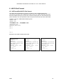
Pressing the Buy Now! button will take you to our online store, where you can order this
product. Note that you will need the hardware fingerprint of the computer where you want to
install the tool, shown in the dialog below (appears when you press Enter Key). After you
complete your purchase, a personal registration key will be sent to you by email. Please store
this key in a safe place.
Pressing the Enter Key button will present you with the following dialog, where you must enter
your name and the registration key.
Once you have entered a valid registration key, press OK. This key will be stored on your PC.
ARIS
5
ARIS ASCII Grid Reader for ArcGIS 10.1/10.2 - User's Manual
It may be necessary to register explicitly as administrator to let the license key be persistent
between sessions (administrator privileges might not be sufficient).
If you have the ARIS License Checker installed, the registration forms are also accessible
through the ARIS License Checker. The ARIS License Checker is available without cost from
http://www.aris.nl/download.
The ARIS License Checker is also a better alternative for registration if you still get reminder
messages after successful registration.
3.1.3 Update license
When your license is not valid anymore through changes on your PC, you can obtain a new
license (fair use policy) after you unregister the license using the ARIS License Checker. The
ARIS License Checker is available without cost from http://www.aris.nl/download.
Send an e-mail to [email protected] with:
• ARIS product name and version
• original hardware fingerprint (active license, if available)
• registration name (active license)
• license key (active license)
• confirmation code (from unregister)
• new hardware fingerprint (from register)
If you are entitled to receive a new license key, a new key will be sent to you by e-mail as
soon as possible (same day, but might also take some days as this is not an automated
process).
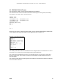
3.2 Floating License
3.2.1 Register
A floating license is handled by a central server and allows a maximum number of users to
simultaneously use the tool. This paragraph describes how to register and start the central
server license manager.
The floating license executable has no evaluation period. After the floating license executable
is installed the Floating License must be registered first. Entering the following command in a
DOS-box does this:
cd "\Program Files (x86)\ARIS\ASCIIGridReader"
ARISAsciiGridReaderA.exe SERVER REGISTER
The "Enter key" dialog-box appears:
ARIS
6
ARIS ASCII Grid Reader for ArcGIS 10.1/10.2 - User's Manual
Remember the hardware fingerprint and send it back to ARIS (mail to [email protected]).
In return you will receive a name and key to register. You can enter these in the "Enter Key"
dialog. A message box should confirm your registration:
Once you have entered a valid registration key, press OK. This key will be stored on your PC.
It may be necessary to register explicitly as administrator to let the license key be persistent
between sessions (administrator privileges might not be sufficient).
After you have registered you can start the license manager:
ARISAsciiGridReaderA.exe SERVER
This shows the server dialog-box for sixty seconds. There can be only one server instance at
a time per program.
ARIS
7
ARIS ASCII Grid Reader for ArcGIS 10.1/10.2 - User's Manual
The Floating License manager may require a port to be opened in the firewall as will be
notified while starting the license manager.
When the server is running the tool can be used on any client machine. A maximum number
of users can use the tool at any time. The server window displays how many users are
running the tool and how many are allowed to run the tool. For each licensed user two
licensed copies are provided in order to enable a user to use the tool in ArcGIS and
ArcCatalog simultaneously.
When someone tries to use the tool while no licenses are available that user receives an error
message:
The tool can only be used after another user releases his copy. Note that it may take a while
(approximately 30 sec.) before the server notices that someone has exited the tool.
Other useful commands on the server-side are:
To start the server and display the server window for a certain time period instead of the
normal 60 seconds:
ARISAsciiGridReaderA.exe SERVER10
This will display the server window for a maximum of 10 seconds. There should be no
blanks between the SERVER and the time-out period.
To start the server window without a timeout use the command:
ARISAsciiGridReaderA.exe SERVERX
Alternatively you can press the timer-button in the server window.
To shut down the server:
ARISAsciiGridReaderA.exe SERVERDOWN
After this the server must be re-started before any clients can start the executable (in this
case ArisFlow).
To unregister the hardware locked program:
ARISAsciiGridReaderA.exe SERVER UNREGISTER
Note to copy the unregister key in order to be able to obtain a new license key.
3.2.2 Update license
When your license is not valid anymore through changes on your PC, you can obtain a new
license (fair use policy) after you unregister the license:
ARIS
8
ARIS ASCII Grid Reader for ArcGIS 10.1/10.2 - User's Manual
ARISAsciiGridReaderA.exe SERVER UNREGISTER
Send an e-mail to [email protected] with:
• ARIS product name and version
• original hardware fingerprint (active license, if available)
• registration name (active license)
• license key (active license)
• confirmation code (from unregister)
• new hardware fingerprint (from register)
If you are entitled to receive a new license key, a new key will be sent to you by e-mail as
soon as possible (same day, but might also take some days as this is not an automated
process).
ARIS
9
ARIS ASCII Grid Reader for ArcGIS 10.1/10.2 - User's Manual
4. Using ASCII Grid files
4.1 Unwanted ArcGIS behaviour
Since ArcGIS 10.0 an ESRI ASCII Grid is always read by the default ArcInfo ASCII Grid
driver integrated in the ArcGIS software. There is no way to create a workaround to let
another driver or reader (like ARIS ASCII Grid Reader) read the ESRI ASCII Grid instead.
This is declared "AS DESIGNED" by ESRI.
In order to use the ARIS ASCII Grid Reader you will have to modify the ASCII Grid slightly by
adding an extra first line (see 8.1 ARIS modified ASCII Grid format).
4.2 Extended features of ARIS ASCII Grid Reader
The ARIS ASCII Grid Reader is capable of reading ASCII Grids with:
• Non-square cell size (rectangular cells)
• Non-numeric Nodata value
• Any order of the keywords in the header
ncols 3
nrows 3
xllcorner 677730.076
yllcorner 415321.484
xcellsize 10
ycellsize 30
NODATA_value !
1 2 !
3 4 5
! 7 8
Figure 3. Display of ASCII Grid with a non-square cellsize (by xcellsize and ycellsize) and a exclamation mark (!) as
Nodata value in ArcMap using ARIS ASCII Grid Reader
See also 8.2 ARIS extended ASCII Grid format for a detailed description.
4.3 Starting to use ARIS ASCII Grid Reader
Due to the unwanted "AS DESIGNED by ESRI" behaviour of ArcGIS 10 you might have to
modify your grids in a way that ArcGIS does not recognize the file as an ASCII Grid but the
ARIS ASCII Grid Reader does.
Add an extra first row to the ASCII Grid file as specified in paragraph 8.1 (ARIS modified
ASCII Grid format). So you add any of the following as the first line:
• newline (empty first row)
• ASCII GRID (ARIS)
• your own meta-data or any other text as long it is not recognized by ArcGIS
The ARIS ASCII Grid Reader will skip the first line and read the rest of the file (being ESRI
ASCII Grid).
Note: if you use a non-square cell size keywords the extra first line is not necessary
Look in the directory <programs>\ARIS\ASCIIGridReader\Example for some examples:
ARIS
10
ARIS ASCII Grid Reader for ArcGIS 10.1/10.2 - User's Manual
• nonsquare_xycellsize_!.asc
ASCII Grid with an empty first row: being read by ARIS ASCII Grid Reader
Contains XCELLSIZE and YCELLSIZE for rectangular cells and an exclamation mark (!) as
NODATA value.
• nonsquare_xydim_null.asc
ASCII Grid with " Example with XDIM YDIM and NULL as NODATA” on the first row: being
read by ARIS ASCII Grid Reader
Contains XDIM and YDIM for rectangular cells and the text “NULL” as NODATA value.
ARIS
11
ARIS ASCII Grid Reader for ArcGIS 10.1/10.2 - User's Manual
4.4 ArcMap
In ArcMap, use the Add Data button to add an ASCII Grid to the map or use Catalog Window
to drag a file to ArcMap:
Figure 3. Add ASCII Grid directly to ArcMap
Note: Only ASCII Grid files that have a file extension *.asc, *.grd, *.agr or *.aig can be used.
Other file extensions will be ignored.
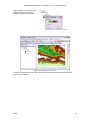
Figure 4. View ASCII Grid between real MIN and MAX in ArcMap
ARIS
12
ARIS ASCII Grid Reader for ArcGIS 10.1/10.2 - User's Manual
Switch quickly to a (another) color
ramp by double clicking in the
legend on the grey scale ramp.
Figure 5. Set another Color Ramp on the ASCII GRID
Figure 6. View ASCII Grid with color ramp
Likewise, all standard functions, such as the Raster Calculator and other Spatial Analyst
functions are available.
ARIS
13
ARIS ASCII Grid Reader for ArcGIS 10.1/10.2 - User's Manual
4.5 ArcCatalog
ArcCatalog recognizes ASCII Grids automatically and a Preview is created instantly.
Figure 7. Preview of an ASCII Grid shown in ArcCatalog.
In ArcCatalog also standard functions are available, such as Export to other format.
ARIS
14
ARIS ASCII Grid Reader for ArcGIS 10.1/10.2 - User's Manual
5. Projections
Projection information is passed to ArcMap and ArcCatalog, if a projection file accompanies
the ASCII grid. Projection files should have the same name as the ASCII file, but with a .prj
extension. For instance, if the ASCII grid is named myraster.asc, the projection file should be
called myraster.prj. Both files should be placed in the same folder.
Even if all your data uses the same projection, you can still add a projection file to the ASCII
grid, since this will stop ArcMap from warning you that your raster doesn’t contain projection
information.
The easiest way to find a valid projection file is to browse the ArcGIS installation folder, in the
subfolder Coordinate Systems. For instance, the projection file for WGS 1984 can be found in
C:\Program Files\ArcGIS\Desktop10.1\Coordinate Systems\Geographic Coordinate Systems\World.
Just copy this file to the folder containing your ASCII grid and rename the copy to match the
base name of the grid.
ARIS
15
ARIS ASCII Grid Reader for ArcGIS 10.1/10.2 - User's Manual
6. FAQ
Q:
A:
After registering my license I get a reminder message every time I start up ArcGIS.
Be sure to register the tool as an administrator. Note: Having administrator-privileges
may not be sufficient.
Q:
I installed the ASCII Grid Reader, but ArcMap and ArcCatalog still don’t see ASCII
Grids.
Check whether the right version of ARIS ASCII Grid Reader is installed (chapter 7) for
your current version of ArcGIS. And if the ASCII Grids comply to the definitions as in
chapter 8 (ASCII Grid Format).
A:
Q:
A:
While browsing to open an ASCII Grid I see many times a license reminder message.
ArcGIS is requesting (too) many times information about all the files you might want
to open in a directory. When you are using a trial license this may result in many
reminder messages. Testing of the trial license is best done in directories with only a
couple of files. Try the files in <programs>\ARIS\ASCIIGridReader\Example. As soon
as ARIS ASCII Grid Reader is registered (licensed) you will not see these reminder
messages anymore.
Q:
A:
After registering my license I still get a reminder message.
Because ArcGIS is requesting (too) many times information the registration might fail.
After restarting ArcGIS it might be solved. Even better is to use the ARIS License
Checker to register your license (no need to start ArcGIS). The ARIS License
Checker is available without cost from http://www.aris.nl/download.
Q:
A:
Some ASCII Grids work, others don’t, why is that?
The ASCII Grid Reader currently only recognizes files that have a file extension *.asc,
*.grd, *.agr or *.aig. If your files are called, say, myraster.ras, or any other file
extension, you have no option other than renaming it. If that’s not feasible for you,
send us an email and we’ll consider adding your file extension in the next version.
Possibly your ASCII Grid is not in the correct format, see chapter 8 (ASCII Grid
Format) to check if your file complies with the ESRI ASCII Grid Format, the ARIS
modified ASCII Grid Format or the ARIS extended ASCII Grid Format.
A:
Q:
A:
Does the ASCII Grid Reader work with ArcGIS 9.2, 9.3 and 9.3.1?
Yes, but you will need ASCII Grid Reader version 2.x which works with ArcGIS 9.2,
9.3 and 9.3.1
Q:
A:
Does the ASCII Grid Reader work with ArcGIS 10.0?
Yes, but you will need ASCII Grid Reader version 3.0 which works with ArcGIS 10.0
Q:
A:
Does the ASCII Grid Reader work with newer ArcGIS versions?
For newer ArcGIS versions you probably need another ASCII Grid Reader version (if
available).
Q:
I have removed ASCII Grid Reader. However when I start ArcGIS I still see pop-up
messages telling me I have to register.
Before de-installing ASCII Grid Reader make sure you have no ArcGIS applications
running. If, by accident, you did remove ASCII grid reader when ArcMap or
ArcCatalog was still running your best bet is to re-install ASCII grid reader and then
remove it again after you exited all ArcGIS applications.
A:
Q:
A:
ARIS
In ArcGIS 9.2 and higher, default support has been added for ASCII grid. Do I still
need the ARIS ASCII Grid Reader?
The default ASCII Grid support in ArcGIS 9.2 until ArcGIS 10.0 shows the grid
stretched between a theoretically minimum and maximum. This usually results in a
grey or black image. The ARIS ASCII Grid Reader shows your grid stretched
16
ARIS ASCII Grid Reader for ArcGIS 10.1/10.2 - User's Manual
between the minimum and maximum values in the ASCII Grid file and thus gives a
realistic view of you grid.
ARIS
17
ARIS ASCII Grid Reader for ArcGIS 10.1/10.2 - User's Manual
7. History
This is the version history for the ARIS ASCII grid reader. The version number can be found
by locating the file asc.dll or ARISAsciiGridReader.dll. In a default ArcGIS installation this file
should be in one of the following folders:
C:\Program Files\Common Files\ESRI\Raster\usr\lib\NTx86\RasterFormats. (older versions)
C:\Program Files\ArcGIS\Desktop10.0\bin\gdalplugins (this version)
Right click on this file and choose Properties. The Version tab contains version information.
Version
1.0
1.1
1.2
1.2.1
1.2.2
2.0.1
2.0.2
3.0.0
3.0.1
3.1.0
3.2.1
3.2.2
3.2.3
ARIS
Features
First release for ArcGIS 8
Added support for .grd and .agr file name extensions
Added support for projections in a .prj file
ArcGIS does not crash anymore when removing ASCII grids
ArcGIS 9.1 does not disappear anymore when starting up with ASCII Grid Reader
Solved the popup message flood occurring sometimes when starting an
unregistered version of ASCII Grid Reader
ArcGIS does not crash anymore when previewing a .prj file
Check on locked files when removing/updating ASCII Grid Reader installation
Installation procedure support for installing with ArcGIS 9.2
Added support for .aig file name extension
Documentation update for ArcGIS 9.3 and 9.3.1
Support for use with ArcGIS 10.0 through modified ASCII Grid format
Added support for non-square cellsize (rectangular cells)
Non-numeric Nodata value is accepted
Any order of keywords in header is made possible
Better check on valid ArcGIS versions in setup.
Program and setup changed for compatibility with ArcGIS 10.1
Added some non-square cellsize examples.
Support for use with ArcGIS 10.2 (and ArcGIS 10.1) and 64-bit Windows (as 32-bit
program).
Support for use with ArcGIS 10.2.1 added.
Floating License as a new license type
18
ARIS ASCII Grid Reader for ArcGIS 10.1/10.2 - User's Manual
8. ASCII Grid Format
8.1 ARIS modified ASCII Grid format
The ARIS ASCII Grid Reader for ArcGIS 10 is able to read a modified ASCII Grid.
The format is the same as the ESRI ASCII Grid Format or the ARIS extended ASCII Grid
format but starting with only one extra line containing anything but an ASCII Grid keyword
(case insensitive). It is also possible to add an empty row at the first line of the ASCII Grid.
<newline | any text != ESRI ASCII GRID keyword>
<NCOLS xxx>
<NROWS xxx>
<XLLCENTER xxx | XLLCORNER xxx>
<YLLCENTER xxx | YLLCORNER xxx>
<CELLSIZE xxx>
{NODATA_VALUE xxx}
row 1
row 2
.
.
.
row n
Examples of the ARIS modified ASCII Grid:
<empty row>
ncols 3
nrows 3
xllcorner 677730.076
yllcorner 415321.484
cellsize 30
NODATA_value -9999
1 2 -9999
3 4 5
-9999 7 8
ARIS
Your own text
ncols
3
nrows
3
xllcorner 677730.076
yllcorner 415321.484
cellsize 30
NODATA_value -9999
1 2 -9999
3 4 5
-9999 7 8
ASCII GRID (ARIS)
ncols 3
nrows 3
xllcorner 677730.076
yllcorner 415321.484
cellsize 30
NODATA_value -9999
1 2 -9999
3 4 5
-9999 7 8
19
ARIS ASCII Grid Reader for ArcGIS 10.1/10.2 - User's Manual
8.2 ARIS extended ASCII Grid format
The ARIS ASCII Grid Reader for ArcGIS 10 is able to read an extended ASCII Grid.
The format is the same as the ESRI ASCII Grid Format or the ARIS modified ASCII Grid
format but also defines:
• Non-square cellsize
• Non-numeric Nodata Values (like "NULL", "NA", "mv', "!", "-")
• Keywords in any order in the header (Even the optional NODATA_VALUE may be the
first keyword in the file)
The first line to make it an ARIS custom ASCII Grid is not necessarily needed with a nonsquare cellsize or with some different order of the keywords (like NODATA_VALUE on the
first line).
{newline | any text != ESRI ASCII GRID keyword}
<NCOLS xxx>
<NROWS xxx>
<XLLCENTER xxx | XLLCORNER xxx>
<YLLCENTER xxx | YLLCORNER xxx>
<CELLSIZE xxx> | <XCELLSIZE xxx> | <XDIM xxx>
| <YCELLSIZE xxx> | <YDIM xxx>
{NODATA_VALUE xxx|aaa}
row 1
row 2
.
.
.
row n
Where
"xxx" is any number and "aaa" is almost any standard ASCII string of one or more characters.
XCELLSIZE and XDIM is the cellsize (dimension) on the X-axis
YCELLSIZE and YDIM is the cellsize (dimension) on the Y-axis
The XDIM and YDIM keywords can be used instead of XCELLSIZE and YCELLSIZE for
better compatibility with other software or other ASCII Grid formats.
Examples of the ARIS extended ASCII Grid:
<empty row>
ncols 3
nrows 3
xllcorner 677730.076
yllcorner 415321.484
cellsize 30
NODATA_value !
1 2 !
3 4 5
! 7 8
ARIS
ncols
3
nrows
3
xllcorner 677730.076
yllcorner 415321.484
xcellsize 30
ycellsize 10
NODATA_value -9999
1 2 -9999
3 4 5
-9999 7 8
ncols 3
nrows 3
xllcorner 677730.076
yllcorner 415321.484
xdim 30
ydim 10
NODATA_value NULL
1 2 NULL
3 4 5
NULL 7 8
20
ARIS ASCII Grid Reader for ArcGIS 10.1/10.2 - User's Manual
8.3 ESRI ASCII Grid Format
This description is taken from the ArcGIS Desktop documentation.
The ASCII file must consist of header information containing a set of keywords, followed by
cell values in row-major order. The file format is:
<NCOLS xxx>
<NROWS xxx>
<XLLCENTER xxx | XLLCORNER xxx>
<YLLCENTER xxx | YLLCORNER xxx>
<CELLSIZE xxx>
{NODATA_VALUE xxx}
row 1
row 2
.
.
.
row n
where xxx is a number, and the keyword nodata_value is optional and defaults to -9999. Row
1 of the data is at the top of the raster, row 2 is just under row 1, and so on.
Example of an ESRI ASCII Grid:
ncols 3
nrows 3
xllcorner 677730.076
yllcorner 415321.484
cellsize 30
NODATA_value -9999
1 2 -9999
3 4 5
-9999 7 8
The nodata_value is the value in the ASCII file to be assigned to those cells whose true value
is unknown. In the raster they will be assigned the keyword NODATA.
Cell values should be delimited by spaces. No carriage returns are necessary at the end of
each row in the raster. The number of columns in the header is used to determine when a
new row begins.
The number of cell values must be equal to the number of rows times the number of columns,
or an error will be returned.
ARIS
21
ARIS ASCII Grid Reader for ArcGIS 10.1/10.2 - User's Manual
Appendix A. License Agreement
ARIS Software License Agreement for ARIS ASCII Grid Reader for ArcGIS
-------------------------------------------------------------------------This is a license agreement and not an agreement for sale. This license agreement
(hereinafter referred to as AGREEMENT) is between the end user (hereinafter referred
to as LICENSEE) and ARIS b.v., The Netherlands (hereinafter referred to as ARIS), and
gives the LICENSEE certain limited rights to use the proprietary ARIS software ASCII
Grid Reader for ArcGIS, examples, on-line and hardcopy documentation and updates (if
applicable), hereinafter referred to as PRODUCT. All rights not specifically granted
in this AGREEMENT are reserved to ARIS.
Ownership and grant of license
------------------------------------------------ARIS and its third party licensor(s) retain exclusive rights, title, and ownership of
the copy of the PRODUCT licensed under this AGREEMENT and hereby grant to LICENSEE a
personal, non-exclusive, non-transferable license to use the PRODUCT based on the
terms and conditions of this AGREEMENT. From the date of receipt, the LICENSEE shall
agree to make reasonable efforts to protect the PRODUCT from unauthorized use,
reproduction, distribution, or publication.
Copyright
--------------The PRODUCT is owned by ARIS and partly by its third party licensor(s) and is
protected by Dutch copyright laws and subject to international laws, treaties, and/or
conventions.
The LICENSEE agrees not to export the PRODUCT into a country that does not have
copyright laws that will protect ARIS's proprietary rights.
Permitted uses
----------------------The LICENSEE may use the number of copies of the PRODUCT for which license fees have
been paid on computer system(s) and/or specific computer network(s) for the LICENSEE's
own internal use.
The LICENSEE may install the number of copies of the PRODUCT for which license or
update fees have been paid onto permanent storage device(s) on computer system(s)
and/or specific computer network(s).
The LICENSEE may make one (1) copy of the PRODUCT for archival purposes only, during
the term of this AGREEMENT, unless the right to make additional copies has been
granted by ARIS to the LICENSEE in writing.
The LICENSEE may use parts of the documentation in other documents for LICENSEE's own
internal use only with the purpose of using or encouraging to use the PRODUCT.
Uses not permitted
-----------------------------The LICENSEE shall not sell, rent, lease, assign, timeshare, or transfer, in whole or
in part, or provide unlicensed third parties access to prior or present versions of
the PRODUCT, any updates, or the LICENSEE's rights under this AGREEMENT.
The LICENSEE shall not reverse, engineer, decompile, or disassemble the PRODUCT, or
make any attempt to alter the license number and other license information shown in
the about box.
The LICENSEE shall not remove or obscure any ARIS copyright or trademark notices.
The LICENSEE shall not make additional copies of the PRODUCT beyond what is laid down
in the "permitted uses" section of this AGREEMENT.
Term
-------The license granted by this AGREEMENT shall commence upon LICENSEE's receipt of the
PRODUCT and shall continue until such time as:· the LICENSEE elects to discontinue the
use of the PRODUCT;
· ARIS terminates the agreement due to the LICENSEE's material breach of this
AGREEMENT.
Upon termination of this AGREEMENT in either instance, LICENSEE shall return to ARIS
the PRODUCT and any whole or partial copies in any form. The parties hereby agree that
all provisions operating to protect the rights of ARIS shall remain in force, should
breach occur.
ARIS
22
ARIS ASCII Grid Reader for ArcGIS 10.1/10.2 - User's Manual
Limited Warranty
-------------------------ARIS warrants that the media upon which the PRODUCT is provided will be free from
defects in materials and workmanship under normal use and service for a period of
ninety (90) days from the date of receipt.
Except for the above express limited warranties, the PRODUCT is provided "as is",
without warranty of any kind, either express or implied, including, but not limited
to, the implied warranty of merchantability and fitness for a particular purpose.
Exclusive Remedy and Limitation of Liability
-------------------------------------------------------------------During the warranty period, ARIS's entire liability and the LICENSEE's exclusive
remedy shall be the return of the license fee paid for the PRODUCT that does not meet
ARIS's limited warranty and that is returned to ARIS or its dealers with a copy of the
LICENSEE's proof of payment.
ARIS shall not be liable for indirect, special, incidental, or consequential damages
related to LICENSEE's use of the PRODUCT, even if ARIS is advised of the possibility
of such damage.
Waivers
------------No failure or delay by ARIS in enforcing any right or remedy under this AGREEMENT
shall be construed as a waiver of any future or other exercise of such right or remedy
by ARIS.
Order of Precedence
--------------------------------Any conflict and/or inconsistency between the terms of this AGREEMENT and any purchase
order, or other terms shall be resolved in favour of the terms expressed in this
AGREEMENT, subject to Dutch law, unless agreed otherwise.
Governing Law
-----------------------This AGREEMENT is governed by the laws of the Netherlands without references to
conflict of laws principles.
Entire Agreement
--------------------------The parties agree that this constitutes the sole and entire agreement of the parties
as to the matter set forth herein and supersedes any previous agreements,
understandings, and arrangements between the parties relating hereto and is effective,
valid, and binding upon the parties.
ARIS is a registered trademark, the Netherlands.
ARIS
23