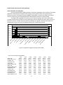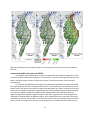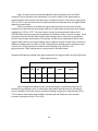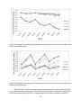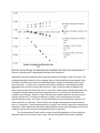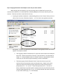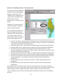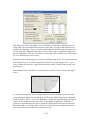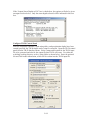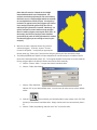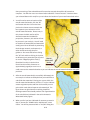
1
Developing a Decision Support System for the DelMarVa Peninsula: a tool to integrate alternative growth scenarios and selected environmental assessment methods into local land use planning FINAL REPORT Submitted to: Maryland Sea Grant By: Glenn E. Moglen and Suzanne Ciavola Department of Civil and Environmental Engineering Virginia Tech Falls Church, Virginia 22043 Claire A. Jantz, Ben Ritter, and A.J. Beck Department of Geography & Earth Science Shippensburg University Shippensburg, PA 17257 James Reilly Reilly Consulting Lafayette Hill, PA 19444 August 2011 Table of Contents: Overview............................................................................................................................................. 4 Definition of the Study Area ......................................................................................................... 5 Growth Trends and Forecasts in the Study Area .............................................................................. 6 Historical Growth in the Study Area ............................................................................................. 6 Forecasts of Growth ...................................................................................................................... 8 Plans for Growth in the Study Area ............................................................................................ 10 MCD’s in the Study Area and why we are using them ............................................................... 10 Using GAMe to Predict MCD housing and job-related footprints .............................................. 12 Examination of the Headship Model .......................................................................................... 13 Testing of the Housing and Employment Allocation Model ....................................................... 17 Alternative Methods to Convert Housing and Jobs to a Development Footprint...................... 20 Job Density .................................................................................................................................. 20 Housing Density .......................................................................................................................... 23 Results ......................................................................................................................................... 23 Methods for Generating Land use / Land cover Forecasts for GISHydro using the SLEUTH Model ......................................................................................................................................... 24 Background on SLEUTH Model Methods .................................................................................... 24 Calibrating the SLEUTH Model .................................................................................................... 25 Forecasting Future Urban Development with SLEUTH .............................................................. 29 Incorporating GAMe’s Forecasts into SLEUTH ............................................................................ 31 Incorporation of SLEUTH Output into GISHydro ........................................................................ 35 Forecast Changes in Runoff Quantity and Quality in the DelMarVa Peninsula ....................... 35 Forecasted Land Use Change ...................................................................................................... 36 Forecasted Loadings and Peak Flow Changes ............................................................................ 37 Sensitivity of Hydrologic Change to Forecasted Land Use Change ............................................ 41 GISHydro “User’s Manual” ArcView tutorial .......................................................................................................................... 44 Getting and using a GISHydroweb account ................................................................................ 49 File Management basics for GISHydroweb ................................................................................. 52 DelMarVa Analysis Exercises Exercise 1: A Collection of Background Exercises From Other Sources ..................................... 56 Exercise 2: The DelMarVa Interface – Choosing Scenarios ........................................................ 57 Exercise 3: Setting the Land Use Condition – Managing Scenarios ............................................ 60 Example: Changing Flood Frequency Behavior .................................................................... 61 Example: TR-20 Rainfall-Runoff Analysis .............................................................................. 62 2 Example: Nutrient Loading Analysis ..................................................................................... 64 Example: Continuing Nutrient Loading Analysis in Excel ...................................................... 65 References ........................................................................................................................................ 70 Appendices Appendix A: Sea Grant Research Files Index ...................................................................... A1-A11 Appendix B: Lands Included in Protected Lands Database .................................................... B1-B1 Appendix C: Relevant Pages from GISHydro2000 User’s Manual for Water Quantity Modeling Exercise I-A: Beginning a Hydrologic Analysis with GISHydro2000 ................................... C-25 Exercise I-B: Watershed Delineation ................................................................................. C-29 Exercise I-C: Discharge Estimation Using Regression Techniques ..................................... C-39 Exercise II-A: Introduction to TR-20 Modeling and Subdivision ........................................ C-43 Exercise II-B: Time of Concentration Determination ......................................................... C-46 Exercise II-C: Calculating Routing Reach Cross Section Parameters .................................. C-61 Exercise II-D: Creation and Execution of TR-20 Model ...................................................... C-63 Appendix D: Relevant Pages from Nutrient Loading Interpolator User’s Manual for Water Quality Modeling Exercise 1a: Initiating a Nutrient Loading Analysis in GISHydro – Starting from an Existing Polygon Shapefile...............................................................................................................D-18 Exercise 1b: Initiating a Nutrient Loading Analysis in GISHydro – Generating your own Watershed Polygon Shapefile ............................................................................................ D-22 Exercise 2: Performing a Conventional/Default Nutrient CBPO Nutrient Loading Analysis ..............................................................................................................................D-26 Exercise 3: Tabular Analysis of the CBPO/GISHydro Nutrient Loading Output File ..........D-27 3 Overview This report presents the methods used in and results produced by a study, “Developing a Decision Support System for the DelMarVa Peninsula – A Tool to Integrate Alternative Growth Scenarios and Environmental Impact Assessments into Local Land Use Planning”, undertaken by the authors to forecast future land use on the DelMarVa peninsula under a range of possible growth scenarios. This report further presents a user’s manual to a GIS-based tool (GISHydro) that was developed to specifically provide access to forecasted land use/land cover forecasts resulting from this study. By providing access to the forecasts through this tool, the user is able to make use of the GIS interface and the hydrologic-specific tools within the GIS to quickly assess the impacts on both water quantity and quality of forecasted future growth within this region. In this project we have modeled the spatial pattern of various futures for the Delmava Peninsula using two models – GAMe and SLEUTH. GAMe (Reilly, 1997a, 1997b) is a coarse scale growth allocation model, which takes regional forecasts and assigns them to smaller, municipal scale units. GAMe has sophisticated demographic and policy simulation capabilities and is the main tool used to simulate trend and the alternatives futures identified in this study. SLEUTH is a cellular automata (CA) model and produces GIS raster images of growth probabilities assigned to 30 meter square grids. So, SLEUTH takes municipal scale trend and alternative growth forecasts (numbers) produced by GAMe and produces fine scale GIS maps of where growth would be likely to occur in each municipality. The resulting GIS maps are embedded into GISHydro, a web-enabled, freeware GIS application, which is the only program DelMarVa citizens will need to use. With GISHydro, local planners and other interested stakeholders are able to view how trend and the various alternative scenarios will likely develop in their town and the Peninsula as a whole. Users can also use the functionality in GISHydro to assess selected hydrologic and water quantity and water quality impacts of any scenario. Users can use GISHydro to simulate BMP’s. This allows users to iterate among various BMP alternatives, arriving at a preferred land development/BMP pattern; preferably one that mitigates adverse impacts on the streams and rivers flowing into the Bay. 4 Definition of the Study Area We illustrate the study area for this research project in the following graphic. While there are no political boundaries defining the northern boundary of the DelMarVa peninsula, it is generally accepted that only part of Maryland’s Cecil County is included. However, for this scope of work, we have chosen to include all of Cecil County into the study area, since doing so provides us with consistent boundary for census and other information and enables us to easily use County-controlled forecasts of growth. As shown in the illustration, the study are consists of part of the three states (Delaware, Maryland and Virginia) and a total of 14 counties. DelMarVa Study Area New Castle Cecil Kent Queen Anne's Kent Caroline Talbot Sussex Dorchester Wicomico Somerset Worcester Accomack States and Counties Delaware Maryland Virginia Northampton 5 Growth Trends and Forecasts in the Study Area Historic Growth in the Study Area During the period 1970 to 2000 each State increased its population in the study area. The largest population increase (234,770 people) and the largest rate of growth (135%) occurred in the three Delaware counties. The Maryland counties added 137,360 people, a growth rate of 89%. The Virginia county of Accomack, grew by 9,590 people while Northampton County lost 1,360 residents. The largest rates of growth at the County scale occurred in Queen Anne County, MD (120% increase), Sussex County, DE (94% increase); Worchester County, MD (90% increase); and Cecil County, MD (61% increase). All other counties grew more modestly (as a growth rate) with the exception of Northampton County, VA which lost population during this 3 decade-long interval. 600.00 500.00 1970 1975 400.00 1980 300.00 1985 1990 200.00 1995 100.00 2000 CA S NE W KE N T, DE TL E, SU DE SS E CA X, DE RO LI N E, M C D DO EC RC IL ,M H ES D TE R, M Q D K U E EE N T N ,M AN D NE SO S, M M ER D SE T, M TA D LB O W T, IC M O D M W I CO O R ,M CE D ST ER AC ,M CO NO D M A RT CK HA ,V M A PT O N ,V A 0.00 Figure 1. Population Change by County 1970 to 2000 TOTAL POPULATION (THOUSANDS) .... 1970 1975 KENT, DE 82.83 92.37 NEW CASTLE, DE 387.58 404.52 SUSSEX, DE 81.06 91.37 CAROLINE, MD 19.91 21.88 CECIL, MD 53.59 56.62 DORCHESTER, MD 29.54 30.18 KENT, MD 16.26 16.76 QUEEN ANNES, MD 18.53 20.62 SOMERSET, MD 18.94 19.34 TALBOT, MD 23.70 25.12 WICOMICO, MD 54.64 60.49 WORCESTER, MD 24.59 28.41 ACCOMACK, VA 28.91 30.87 NORTHAMPTON, VA 14.47 15.03 1980 98.27 398.55 98.11 23.21 60.63 30.54 16.70 25.69 19.11 25.73 64.64 30.88 31.27 14.57 6 1985 102.83 411.52 103.94 24.44 64.11 29.86 17.01 28.73 19.71 27.59 68.36 33.05 31.07 13.69 1990 111.63 443.57 113.86 27.12 71.86 30.25 17.86 34.09 23.46 30.66 74.64 35.24 31.67 13.08 1995 120.50 473.42 134.37 28.78 78.46 30.49 18.87 36.39 24.55 32.30 81.24 41.00 35.00 13.15 2000 127.03 501.55 157.65 29.79 86.33 30.69 19.21 40.73 24.76 33.85 84.90 46.81 38.50 13.10 Employment change corresponded to population change. The largest employment growth, numerically and in terms of percent increase occurred in Delaware’s three counties, which added 229,830 new jobs between 1970 and 2000 for a total increase of jobs (1970 to 2000) of almost 84%. The Maryland portion of the study area grew its job base by 88,3200 for an increase of just over 73%. Virginia had the lowest rate of growth at almost 30%. While this might pale compared to the other States, one has to recognize that Virginia added 10% to its job based every decade for 3 decades! The fastest rates of County employment growth were in: Queen Anne County MD, which increased by 10,400 jobs achieving a growth rate of 155%; Worchester County, MD which added 17,200 jobs for a rate of 121%; Talbot County MD, with 13,280 new jobs for a 106% increase; and, Sussex County DE which added 40,570 jobs – an increase of 98%. Only Northampton County VA lost jobs during the period. 400 350 300 1970 250 1975 1980 200 1985 150 1990 100 1995 2000 50 NE W CA S KE N T, D TL E E SU ,D E SS EX CA ,D RO E LI N E, M DO C D RC EC I L H ES , M TE D R, Q M U K EE EN D N T AN , M D SO NE S M ER , M SE D TA T, M LB D W IC OT, O M M W D IC O R O CE , ST MD AC ER ,M NO CO D RT MA HA CK ,V M A PT O N ,V A 0 Figure 2. Employment Change by County 1970 to 2000 7 TOTAL EMPLOYMENT (THOUSANDS) .... 1970 1975 1980 KENT, DE TOTAL POPULATION 42.22 (THOUSANDS) 44.75 46.41 .... NEW CASTLE, DE 190.83 203.10 219.08 SUSSEX, DE 41.53 44.29 46.64 CAROLINE, MD 8.13 7.84 8.50 CECIL, MD 20.98 17.80 19.14 DORCHESTER, MD 13.94 14.33 14.37 KENT, MD 7.30 7.78 8.08 QUEEN ANNES, MD 6.71 7.33 8.41 SOMERSET, MD 6.75 7.25 7.19 TALBOT, MD 12.58 14.29 15.97 WICOMICO, MD 29.97 31.41 33.64 WORCESTER, MD 14.20 16.21 19.18 ACCOMACK, VA 11.47 14.02 15.52 NORTHAMPTON, VA 6.72 6.79 6.87 1985 51.32 250.02 57.35 9.59 20.41 14.81 8.36 9.69 7.53 17.67 39.70 24.15 15.42 6.42 1990 58.61 298.47 65.95 11.10 25.81 16.22 10.15 12.81 9.00 21.44 45.12 27.26 16.63 5.97 1995 66.67 308.35 71.76 11.63 27.32 15.63 10.56 14.09 8.92 22.95 48.83 28.94 16.98 5.89 2000 71.00 351.31 82.11 13.33 32.03 15.72 11.30 17.11 9.81 25.86 52.32 31.40 16.98 6.62 Forecasts of Growth Population forecasts for the study area were collected from the Federal Government and from a variety of public and quasi-public agencies. All predict that the DelMarVa Peninsula will continue to grow. Figure 3 is a table of State level residential growth prepared by the Department of Commerce, Bureau of the Census. Shown are two forecasts for the three states. Figure 4 displays population forecasts for the Counties included in our Study area. All of these forecasts were prepared by State or other quasi-public agencies, with the exception that we have included a set of forecasts prepared by a private company, Woods and Poole. Of note, only the Woods and Poole forecast included a lot of demographic detail and only Woods and Poole produced an econometric forecast where population, employment and income were computed together. A more moderate employment growth is anticipated than the region experienced in the period 1970 to 2000. Projections of the Total Population of States: 1995 to 2025 (Numbers in thousands. Resident population. For more detailed information, see Population Paper Listing #47, "Population Projections for States, by Age, Sex, Race, and Hispanic Origin: 1995 to 2025.") July 1, July 1, July 1, July 1, SERIES A July 1, 1995 2000 2005 2015 2025 717 768 800 832 861 Delaware............ 5,042 5,275 5,467 5,862 6,274 Maryland............ 6,997 7,324 7,921 8,466 Virginia............ 6,618 July 1, July 1, July 1, July 1, SERIES B July 1, 1995 2000 2005 2015 2025 758 793 851 899 Delaware............ 717 5,261 5,426 5,736 6,072 Maryland............5,042 6,965 7,234 7,708 8,165 Virginia............ 6,618 Figure 3. Census growth forecasts for DE, MD and VA 8 Delaware Delaware CEDS New Castle Kent Sussex 2000 501933 127085 157430 2005 524815 138349 175749 2010 547356 146259 194615 2015 567193 152797 212880 2020 583980 158986 229441 2025 597348 164261 243392 Woods and Poole New Castle Kent Sussex 127034 501552 157648 134658 525560 170886 142431 550230 184180 150612 576503 197880 159130 603960 211889 168014 177394 632773 662960.6 226349 241795.8 Maryland MDP 2008 Caroline Cecil Dorchester Kent Queen Anne's Somerset Talbot Wicomico Worcester 2000 29,772 85,951 30,674 19,197 40,563 24,747 33,812 84,644 46,543 2008 33,138 99,926 31,998 20,151 47,091 26,119 36,215 94,046 49,274 2010 34,100 103,850 32,350 20,300 48,650 26,550 36,950 96,100 50,550 2015 2020 40,300 130,350 36,300 22,200 55,650 28,300 40,050 107,450 56,250 2025 2030 46,000 155,000 38,850 23,400 61,900 29,350 42,100 117,550 60,000 Woods & Poole Cecil Kent Queen Anne's Caroline Talbot Dorchester Wicomico Worcester Somerset 86,330 19,210 40,730 29,790 33,850 30,690 84,900 46,810 24,760 95,820 20,050 46,110 32,270 36,960 30,750 90,230 49,840 26,320 98,240 20,270 47,490 32,910 37,800 30,800 91,620 50,620 26,730 104,560 20,890 51,100 34,610 39,940 30,980 95,340 52,730 27,810 111,060 21,580 54,760 36,390 42,100 31,240 99,230 54,950 28,960 117,850 22,330 58,530 38,220 44,430 31,540 103,380 57,260 30,190 125,055 23,106 62,560 40,142 46,889 31,843 107,704 59,667 31,472 Virginia State Forecast Accomack Northampton 2000 31,703 13,061 2008 38,305 13,093 2010 41,300 12,400 2015 2020 44,500 12,200 2025 2030 46,500 12,000 Woods & Poole Northampton Accomack 38495 13104 38719 12903 39013 12760 39473 12656 40028 12630 40706 12571 41395 12512 Figure 4. Forecasts of Population for the Counties in the Study area 2005-2030 are based on the Delaware Population Consortium 2007 Annual Population Projections 9 2030 606338 168340 254525 Woods and Pool Forecast for Counties in Study Area TOTAL EMPLOYMENT (THOUSANDS) .... 2000 2010 2015 TOTAL POPULATION 127.03 (THOUSANDS) 142.43 150.61 .... KENT, DE NEW CASTLE, DE 501.55 550.23 576.50 SUSSEX, DE 157.65 184.18 197.88 CAROLINE, MD 29.79 32.91 34.61 CECIL, MD 86.33 98.24 104.56 DORCHESTER, MD 30.69 30.80 30.98 KENT, MD 19.21 20.27 20.89 QUEEN ANNES, MD 40.73 47.49 51.10 SOMERSET, MD 24.76 26.73 27.81 TALBOT, MD 33.85 37.80 39.94 WICOMICO, MD 84.90 91.62 95.34 WORCESTER, MD 46.81 50.62 52.73 ACCOMACK, VA 38.50 39.01 39.47 NORTHAMPTON, VA 13.10 12.76 12.66 2020 159.13 603.96 211.89 36.39 111.06 31.24 21.58 54.76 28.96 42.10 99.23 54.95 40.03 12.63 2025 # Change % Change 168.01 40.98 32% 632.77 131.22 26% 226.35 68.70 44% 38.22 8.43 28% 117.85 31.51 37% 31.54 0.86 3% 22.33 3.12 16% 58.53 17.80 44% 30.19 5.43 22% 44.43 10.58 31% 103.38 18.48 22% 57.26 10.45 22% 40.71 2.21 6% 12.57 (0.53) -4% Figure 5. Forecast of Employment for the Counties in the Study area Plans for Growth in the Study Area The study team also collected and reviewed 143 planning, policy and capital budget documents produced by the three states and the thirteen counties. We examined these documents to identify major policy or planning initiatives which might encourage growth in a particular manner which we might simulate. We also examined capital budgets, especially transportation documents as major new transportation routes tend to encourage development within their corridors. A list of these documents is included in Appendix A. We did not indentify a major project or plan which might shift growth or which might encourage growth to rapidly increase. For example, we were unable to find a capital plan budget calling for a third Bay bridge or for the development of a new highway or arterial. This work was done in 2008. At a meeting of public officials held in 2010, we encouraged state and regional officials to update us with new plans and budgets. No updates were provided. MCD’s in the Study Area and why we are using them Within the study area, the US Department of Commerce, Census Bureau, has defined 142 Minor Civil Divisions (MCD’s). MCD’s are sub-county areas “which have stable boundaries and a recognizable name”.1 The following map illustrates the MCD’s in the DelMarVa Study area. 1 See http://www.census.gov/mso/www/rsf/geo_con/sld009.htm 10 MCDs N MCD s N MCD’s were chosen for use in this study because the main growth allocation equations used in GAMe (such as the equation to predict future employment) were originally developed using MCD data (Townships, Towns and Cities) in New Jersey. The size distribution of the MCD’s found in the DelMarVa falls within the range of the NJ MCD datasets. Use of larger or smaller areas than that used in the original GAMe research would violate good statistical modeling procedures and necessitate a complete re-examination of all GAMe equations. There is another advantage in using the more intimate MCD scale. Past personal experience in growth allocation modeling has revealed that county and larger scale predictions are only meaningful to a small number of specialists who work with such information on a regular basis. By using the more local 11 MCD’s, we hope that GAMe forecasts – and especially the trend forecast – will be a scale which enables local citizens to think about the likelihood of these predictions. Using GAMe to Predict MCD housing and job-related footprints GAMe is a model consisting of both statistical equations and mathematical models which assigns county-scale forecasts of people and jobs to the MCD’s within that county2. GAMe was originally developed for use by the New Jersey State Planning Commission to test various policy ideas. Subsequently, GAMe was adopted for use by Rutgers University to assess the original New Jersey State Plan and all subsequent revisions to that plan. The principal algorithms in GAMe have been published in leading academic journals3. Many of the statistical impact models have also been published. As used in this study, only the growth allocation portion of GAMe was used as described in the following paragraphs. GAMe’s first task is to convert county forecasts of population (exogenous to the model) into an estimate of housing and to estimate the number of new housing units which must be built (by the forecast year) in the each study area County to accommodate the forecasted population. GAMe uses a Headship model to make this population to housing conversion. GAMe then assigns the total housing in the County to each MCD in the County using a mathematical model. To calculate MCD employment, GAMe uses two more statistical models: the first calculates the miles of local roadway in each MCD; and, the second uses road density (derived from total miles) as well as the forecasted MCD housing to produce MCD jobs. Both the MCD housing estimate and the MCD job estimate are ‘controlled’ so that the total of all predicted MCD-based jobs or MCD-based houses agree with the total exogenous County forecast. This agreement is accomplished by using a simple percentage formula. Finally, GAMe converts housing and jobs into an estimate of square feet of space (termed development footprint) which is likely to result from this growth forecast. Using GIS information about the actual available supply of buildable land in the MCD, GAMe determines if there is enough of this available land to accommodate the development footprint. If not, the model re-allocates excess growth to the other MCD’s in the County. The study objective was to use GAMe’s demographically rich headship methods to produce alternative forecasts of housing. Another objective was to use GAMe’s relatively accuracy allocation models to produce land consumption forecasts which would inform the SLEUTH model. 2 The full GAMe model also includes a variety of environmental, social and fiscal impact models which enables the user to assess the benefits and disadvantages of any growth scenario. 3 Reilly, J. (1997a). "A method of assigning population and a progress report on the use of a spatial simulation model." Environment and Planning B-Planning & Design 24(5): 725-739. Reilly, J. (1997b). "A methodology to assign regional employment to municipalities." Computers, Environment and Urban Systems 21(6): 407-424. 12 Diagram of the GAMe Model Cohorts Exogenous Pop by Cnty Alts HS Alts Seasonal Alts Grp Hsing Alts ARS – Housing Need By Cnty Exogenous Jobs by Cnty Vacancy Alts First Cut – DUS to MCD Est. of MCD Houses Miles of MCD Roads Land Available Alts Est. of MCD Jobs Density Alts Final Land Fitted Forecast of Jobs & Houses by MCD Examination of the Headship Model The Headship model uses age-specific cohorts, which represent the percentage of the people in that age group which would head households. (Where more detailed demographic information is available (not in the study area or in its forecasts) separate cohorts can be constructed for specific sex and race groups.) Figure 6 displays a sample of this method using year 2000 Census data for all inputs. We start with a (Kent) county population of 127,085 persons. We determine household population by subtracting the total number of persons who reside in Group Housing (nursing homes, prisons, military barracks etc). In this example, we have 8 age cohorts and the percentage to the left of each cohort represents the percentage of the total population within that cohort. For example, almost 23% of County’s population is age 0 to 14. Multiplying the cohort by the total household population produces the total number of persons within this cohort who live in households. Again, by example, there are 28,167 persons in the County between the age of 0 and 14 living in households. HSR (headship rate) represents the percentage of this population who head households. In the 0 to 14 age group no one heads their own household – thank goodness. We then sum the number of heads of households for each cohort to produce the total households in the County. In this case there are a total of 47,224 heads of households. Next we look at the total dwelling units (houses) in the county – there are 50,481. We then subtract seasonal (vacation homes etc) and vacant houses from the total. In the displayed example, we need no new houses since the number of residual existing houses (total DUS minus seasonal and vacant) was exactly equal to the 13 total number of householders. This example demonstrates an important model assumption – that for each head of a household, there MUST be an occupied, non-seasonal dwelling unit. 2000 total pop grp qrts Population 3,630 127085 123455 0 to 14 15 to 24 25 to 34 35 to 44 45 to 54 55 to 64 65 to 74 75 + 2000 Household Population Cohort pop by cohort HSR Hhse hhlders DU2000 seasonal vacant new DUS Needed 0.228159 28167 0 0 47224 50,481 364 2893 0 0.145733 17991 0.153518 2762 0.135515 16730 0.504603 8442 0.162153 20019 0.559478 11200 0.124738 15400 0.585017 9009 0.08689 10727 0.604735 6487 0.066439 8202 0.657993 5397 0.050372 6219 0.631481 3927 123455 47224 Figure 6. Example of using Headship to convert population to housing This same model structure is used to forecast future houses. We can produce differing housing forecasts using different county growth forecasts. We can also produce differing forecasts from the same county population forecast by altering: group housing estimates, the percentage of persons in each cohort or in one or more of the cohorts; seasonal housing and vacancy. One can also produce alternative headship rates which we think likely in the future. In this study we produced different MCD level growth footprint forecasts by using the various public and private County-scale population and employment forecasts previously identified in this report. We also developed a set of headship rate alternatives which were used. Finally, we developed alternative estimates of housing and job-related areal requirements. We attempted to develop alternative headship cohorts and alternative seasonal housing estimates. The literature on seasonal housing forecasting was reviewed and it was discovered that a model for this purpose has not been developed. The best source of information on this topic was a monograph from the Harvard University Joint Center for Housing Studies4, which reported that seasonal housing need is associated with the number of persons in the age cohorts 45 to 64. However, the scale of this association was not reported, although the report implied that this relationship occurs at a very large regional scale. We attempted to identify a relationship between this cohort and seasonal housing within a county without success. Our guess is that there might be a predictive relationship at something approaching SMSA scale, but we still had no method to allocate this demand to specific locations. Further, we did not feel comfortable simply increasing seasonal housing with population, given the very location-specific nature of this specialty housing. Therefore we held seasonal housing to the year 2000 number for all simulations. This likely produces an underestimation of future seasonal housing and a resulting understatement of the development footprint. Likewise, we felt very uncomfortable producing group housing or vacancy alternatives. One could easily produce some mechanical difference, say plus some amount added to the year 2000 value, but we felt we could not justify this change. Vacancy can be the result of economics rather than policy. Group housing is affected by income and health. In the absence of a more complete econometric model, we elected to use year 2000 values in all simulations. 4 Household Projections in Retrospect and Prospect: Lessons Learned and Applied to New 2005-2025 Projections. George S. Masnick and Eric S. Belsky, July 2009 W09-5, Joint Center for Housing Studies Harvard University 14 Cohort and headship rates used in this study were derived from the Woods and Poole forecast data and they reflect county-specific differences based on the year 2000 population in each county. Of note, migration of Hispanic persons has not been substantial in the study area, with the exception of New Castle County DE, where very moderate growth has occurred. The continuation of this pattern is assumed in the Woods and Poole cohorts. We did develop alternatives to the Woods and Poole -based headship rates. These changes were based on the following table which displays the national trend in headship rates from 1950 through 2000 This table shows that while household formation increased through 1980, since then the household rate has either declined or stagnated. Therefore, we developed a new series of headship rates for this study: one where the headship rate for all age cohorts older than 14 increased slightly every year after 2015 and another where the headship rates for the same groups declined slightly after 2015. A sample of these headship rate tables (for Caroline County, MD) is displayed below. Figure 7. Changes in Headship Rates 1950 to 2000 15 Caroline 0 to 14 15 to 24 25 to 34 35 to 44 45 to 54 55 to 64 65 to 74 75 + 2000 2005 2010 0 0.130177 0.461437 0.532006 0.557127 0.591947 0.629539 0.629695 0 0.130177 0.461437 0.532006 0.557127 0.591947 0.629539 0.629695 0 0.130177 0.461437 0.532006 0.557127 0.591947 0.629539 0.629695 2015 2020 2025 3% per decade growth after 2010 0.13213 0.468358 0.539986 0.565484 0.600827 0.638983 0.63914 0.134083 0.47528 0.547966 0.57384 0.609706 0.648426 0.648586 0.136094 0.482409 0.556186 0.582448 0.618851 0.658152 0.658315 2030 0.138105 0.489538 0.564405 0.591056 0.627997 0.667878 0.668043 Figure 8. Headship Table forecasting higher housing participation Caroline 0 to 14 15 to 24 25 to 34 35 to 44 45 to 54 55 to 64 65 to 74 75 + 2000 2005 2010 0 0.130177 0.461437 0.532006 0.557127 0.591947 0.629539 0.629695 0 0.130177 0.461437 0.532006 0.557127 0.591947 0.629539 0.629695 0 0.130177 0.461437 0.532006 0.557127 0.591947 0.629539 0.629695 2015 2020 2025 3% per decade decline after 2010 0.128225 0.454515 0.524026 0.54877 0.583068 0.620096 0.62025 0.126272 0.447594 0.516046 0.540413 0.574189 0.610653 0.610804 0.124378 0.44088 0.508305 0.532307 0.565576 0.601493 0.601642 2030 0.122484 0.434166 0.500565 0.5242 0.556963 0.592334 0.59248 Figure 9. Headship Table Forecasting declining housing participation The following table displays the differing estimates of total housing (TDUS) and new housing (New Dus) which result when using the State and Woods & Poole forecasts in combination with the headship alternatives. Shown are the results for the forecast year 2030. We also display the total houses in each county for the year 2000 as a point of reference. 16 Kent, DE New Castle, DE Sussex, DE Caroline Cecil Dorchester Kent Queen Anne Somerset Talbot Wicomico Worchester Northampton VA Accomack VA 2030 State Forecasts Constant DU2000 Population Est. TDUS New Dus 50,481 168,340 71,227 20,746 199,521 606,338 257,097 57,576 93,070 254,525 142,014 48,944 46,000 12,028 19,830 7,802 155,000 34,461 65,500 31,039 38,850 14,681 18,908 4,227 23,400 9,410 11,704 2,294 61,900 16,674 26,454 9,780 29,350 10,092 13,898 3,806 42,100 16,500 21,609 5,109 117,550 34,401 50,406 16,005 60,000 47,360 54,102 6,742 6,547 12,000 6,145 -402 19,550 46,500 21,606 2,056 Headship Growth Est. TDUS New Dus 73,266 22,785 264,493 64,972 145,360 52,290 20,981 8,953 69,292 34,831 19,939 5,258 12,311 2,901 27,983 11,309 14,639 4,547 22,791 6,291 53,343 18,942 55,712 8,352 6,445 -102 22,662 3,112 Headship Decline Est. TDUS New Dus 65,347 14,866 235,773 36,252 132,367 39,297 18,713 6,685 61,821 27,360 17,907 3,226 11,116 1,706 24,971 8,297 13,179 13,179 20,461 3,961 47,556 13,155 52,540 5,180 5,854 -693 20,580 1,030 Kent, DE New Castle, DE Sussex, DE Caroline Cecil Dorchester Kent Queen Anne Somerset Talbot Wicomico Worchester Northampton VA Accomack VA 2030 W&P Forecasts Constant DU2000 Population Est. TDUS New Dus 50,481 177,394 74,963 24,482 199,521 662,961 280,802 81,281 93,070 241,796 136,361 43,291 12,028 40,145 17,401 5,373 34,461 125,045 53,372 18,911 31,856 14,681 15,806 1,125 23,109 9,410 11,573 2,163 62,551 16,674 26,720 10,046 31,464 10,092 14,950 4,858 46,898 16,500 23,854 7,354 107,712 34,401 46,259 11,858 47,360 59,665 53,953 6,593 6,547 12,512 6,362 -185 19,550 41,395 19,664 114 Headship Growth Est. TDUS New Dus 77,114 26,633 288,909 89,388 139,537 46,467 18,404 6,376 56,425 21,964 16,648 1,967 12,171 2,761 28,265 11,591 15,755 5,663 25,173 8,673 48,943 14,542 55,554 8,194 6,674 127 20,603 1,053 Headship Decline Est. TDUS New Dus 68,760 18,279 257,427 57,906 127,203 34,133 16,428 4,400 50,409 15,948 14,989 308 10,992 1,582 25,222 8,548 14,169 4,077 22,574 6,074 43,654 9,253 52,399 5,039 6,058 -489 18,754 -796 Testing of the Housing and Employment Allocation Model Backcasting is a formal method to determine the accuracy of any predictive model. In backcasting one uses historic data as input to the model, which then predicts a more recent, but still historic year. For example, information about 1980 and 1990 were used to predict housing and employment in 2000. The value of this methodology is that the prediction can be compared to actual data. In the following tables we present results of the model backcasting testing for each county in the study area. In all testing we predicted year 2000 values for MCD’s, using MCD data from 1980 and 1990. Our results are presented using two metrics. The first metric, termed RSq Total, is a measure of the correlation between the total forecasted value (either housing or jobs in an each MCD in the county) and the actual count reported in the Census or other data source (Woods and Poole employment data). It can be seen that the housing model produced excellent results in every county in Maryland and Delaware, but was less predictive in the two Virginia counties. After much analysis the cause of this Virginia problem was discovered. We found that with each census the boundaries of census tracts and MCDs were changed, with the result that one could not reliably use historic records as each census reported the information for a different location. The second metric, termed RSq Δ (R Square Delta), is a statistical comparison of only the change in the housing or jobs in each MCD in a county. In other words it compares the difference in total growth (or decline) reported in the Census to the growth or decline predicted in the model. This second metric is much more difficult value to predict as it directly reflects routine statistical outlier errors. It also was an interesting bell weather of spatial growth change to the historic pattern, as both models implicitly assume that past historic growth trends will continue into the future. Where we had low RSq Δ’s we found that this metric reflected changes in the spatial pattern of growth. Where growth patterns 17 continued as infill to previous growth, the correlations were high. Again backcasting results in Virginia were affected by the inconsistent data problem. We also have included a table showing the exact results for Kent County so that readers can have a taste of real model results and compare them to the actual values. Housing Allocation Backcasting Results KENT, DE NEW CASTLE, DE SUSSEX, DE RSq Total0.99 0.76 0.99 CAROLINE, MD CECIL, MD DORCHESTER, MD KENT, MD QUEEN ANNES, MD SOMERSET, MD TALBOT, MD WICOMICO, MD WORCESTER, MD 0.97 0.99 0.99 0.93 0.99 0.96 0.99 0.99 0.99 ACCOMACK, VA NORTHAMPTON, VA 0.66 0.44 RSq Δ 0.99 0.19 0.85 0.03 0.88 0.05 0.57 0.98 0.16 0.95 0.56 0.46 N/A N/A Sample of MCD Housing Prediction using Kent County Total Housing Model Change in Housing Δ Census Δ Model NAME GEO_IDTXT Census Central Kent 1000190444 6962 6,700 1375 1113 Dover 1000190740 26632 26,533 4508 4409 Felton 1000190888 2172 2,230 313 371 Harrington 1000191332 4110 4,228 585 703 Kenton 1000191480 1919 1,889 344 314 Milford North 1000192220 3910 4,103 489 682 Smyrna 1000193700 4776 4,798 775 797 Figure 10. Predicting year 2000 housing using housing change 1980 to 1990 18 Employment Backcast to predict year 2000 Jobs Sample of MCD Job Prediction using Kent County Total Housing Change in Housing NAME GEO_IDTXT Census Model Δ Census Δ Model Central Kent1000190444 1,759 1,666 312 219 Dover 1000190740 45,969 39,530 8,137 1,698 Felton 1000190888 1,010 964 179 133 Harrington 1000191332 3,481 3,045 615 179 1000191480 420 436 74 90 Kenton Milford North 1000192220 4,836 4,026 857 47 Smyrna 1000193700 4,808 4,114 852 158 Employment Allocation Backcasting Results RSq TotalRSq Δ KENT, DE 0.99 0.97 NEW CASTLE, DE 0.91 0.04 SUSSEX, DE 0.99 0.99 CAROLINE, MD 0.97 CECIL, MD 0.98 DORCHESTER, 0.99 MD KENT, MD 0.99 QUEEN ANNES,0.99 MD SOMERSET, MD0.99 TALBOT, MD 0.99 WICOMICO, MD0.99 WORCESTER, MD 0.99 0.80 0.62 0.78 0.54 0.85 0.53 0.19 0.68 0.99 ACCOMACK, VA0.93 NORTHAMPTON, 0.96 VA 0.31 0.19 So how did the models do? In several counties the results are obvious, both metrics had very high scores. But in other counties, the results were not as good. For example, in Talbot County we got very good model agreement when the total housing and employment numbers, but much less satisfying results when we looked at the difference. Overall, we were very satisfied with our results, given the inherent limitations of historic pattern driven modeling. Because of the very good model performance in both Delaware and Maryland, we felt comfortable predicting results for Virginia. However, these results will only apply to the year 2000 MCD boundary areas. If the State again alters MCD boundaries, our results cannot be assigned to these areas if they differ from those used in this study. Model calibration is a process of adjusting a value in an equation or process to achieve a more symmetric result. Based on the very good results from our backcasting, it was decided that calibration of the models was not needed. Just as importantly, we were not convinced that calibrating the model to 19 more closely conform to growth patterns between 1980 and 1990 (to predict 2000) would serve much benefit, since the actual forecasting would use the period 1990 to 2000 to predict the forecast years of 2010, 2020 and 2030. Further, making such calibrations assumes that these MCD-based new growth patterns would continue through the study period. A more honest assessment would be that, as we have seen in the backcasting, our models should do a very good job in many places, but will have difficulty in places which new growth patterns emerge. Alternative Methods to Convert Housing and Jobs to a Development Footprint Once housing and jobs had been assigned to an MCD, GAMe needed to convert this growth prediction into an estimate of land consumed in the MCD. To accomplish this task we explored several methods to convert houses into developed acres and to estimate how many jobs one can expect to find in an acre of build non-residential development. All of the methods attempt to produce MCD-specific estimates; we did not want to use some sort of abstract density or industry standard and apply it everywhere in a region. We felt it important that the development character of each MCD be preserved. We started by estimating existing housing and job related development in each MCD. Most of the methods employed for this work relied on GIS Land Use/Land Cover information derived from LandSat remotely sensed data. Job Density Alternative MCD job densities (jobs per acres of developed land) were estimated using two entirely different methods. Our first approach, termed the “building type” method, associated detailed MCD level employment by type to published sq footage standards for various building types. For example, if we had 10 widget makers in an MCD who required generally a specific commercial building type due to the nature of their work, and we knew that the space standard for that building type was 300 sq feet of built space per employee, then our estimate of built space for all widget makers in that MCD would be 3000 sq feet. What made our employment building footprints different was the unique mix of employment in each MCD. We developed the building type method by collecting several published space studies which reported the average square footage per employee several types of job-related building types. A summary of these reports is displayed in the following table. Employment per Square Foot of space by Building type Sq Feet of Built space per employee #1 #2 Industry 340 924 Warehouse General 540 High rack 860 1225 Office 205 Low rise 466 High Rise 300 Retail Local 215 585 Superstore 970 1023 Other 350 672 #3 365 540 860 205 215 970 350 Sources: 1. English Partnerships "Employment Densities a simple guide, September 2001 2. Employment Density Study Summary report, Southern California Associations of Governments, prepared by Natelson Company, Inc, October 31 2001 3. English Partnerships "Employment Densities a full guide, July 200 20 We note that all of the English space standards report higher employment densities than those reported in the California study. We used these reports to develop our own table of employment for each of 5 types of job-related generalized structures. Of note, we reduced the estimate of square footage per employee for retail, based on the trend that an increasing percentage of purchasing is done on the Internet, therefore the demand for space at the MCD level should decline. We also used a conservative value for office to represent the increasing trend for employees to work at home, and for office workers to use share office space. Square feet per building type used in this study Industrial Warehouse Office Retail Other 500 800 325 600 600 We were fortunate to obtain very detailed MCD level employment information, which identified at-place employment by major classifications. A sample of this data is displayed in the following table. The top value, TOT_00 is the total employment in this MCD in the year 2000. Each of the rows with follow are subsets of that total for each classification of employment. So, for example, the table shows that there were 359 construction jobs and 46 manufacturing jobs etc. MCD Level Employment data for year 2000 TOT_00 NR_00 CON_00 MAN_00 WHL_00 RET_00 TRANS_00 INF_00 FIN_00 PRO_00 EDU_00 ART_00 OTH_00 ADM_00 MIL_00 1759 62 359 46 10 150 154 19 92 159 455 29 67 163 0 We then associated each of the employment types to one of the five building types, as shown in the following table. We also increased the building space for each type by a factor we termed “AFR” (area of impervious surface compared to the floor area used by employees). AFR increased the built area to account for parking and access roads. 21 Employment Building type AFR assumptions used in this report Employment NR_00 CON_00 MAN_00 WHL_00 RET_00 TRANS_00 INF_00 FIN_00 PRO_00 EDU_00 ART_00 OTH_00 ADM_00 MIL_00 Building Type office Warehouse Industrial Warehouse Retail office office office office office office office office 0 AFR 1.4 1.42 1.35 1.42 1.59 1.4 1.4 1.4 1.4 1.4 1.4 1.4 1.4 Since employment varied by MCD both the statistical method and the building type method produced unique values for each MCD. Our second method relied on a statistical model which predicts the percentage of urbanized area which is job related in each MCD. The equation is: LN%JobArea = .78818 * LN(TDUS/AreaSqMiles) – 7.9301 where: LN%JobArea = natural log of the percentage of the total urban area in each MCD TDUS = total dwelling units in the MCD AreaSqMiles = total land (sq miles) in the MCD Using this equation the number of job-related acres in each MCD was estimated for 2001, as we used a 2001 land use/land cover dataset of urbanized area. We then divided the total MCD year 2000 employment by the total acres of job-related land to estimate the number of jobs per job-related acre in each MCD. We compared the result of both methods and found them to be in general agreement. We also tried to validate our employment density estimates by comparing our estimate of employment area (produced by the statistical model) to estimates of job related land produced by using the Maryland Department of Planning (MDP) land inventory coverages for those MCDs located within Maryland. The MDP land use inventory relies on areas derived from parcel plot lines which were rubbersheeted (made to visually associate) with aerial imagery within a GIS. These coverages were then unioned with zoning coverages to determine land use. MDP’s records also included the parcel size of each land plot which was taken from the County tax records as well as information about the value of improvements on the lots. As a result of this improvement valuation, developed lots could be differentiated from undeveloped or under-developed parcels. These associations enabled MDP to 22 identify all developed parcels with job-related zoning in the State. For each MCD in the study area the total job-related area is then obtained through addition. We compared the results of our statistical method (total acres of job-related development) to those developed using the MDP data set. It is known that inherent in each approach there are problems. The remote sensing data set we used with the statistical model has difficulty differentiating low density development when it occurs on lots thick with mature trees. Therefore, it tends to both under-estimate development in low density, wooded areas and to over-estimate developed areas if the analysis incorrectly identifies treed areas as developed areas. The MDP inventory is absolutely reflective of parcel size by zoning, but likely is less reliable as in index of developed footprint. For example, if a business built a warehouse of 10,000 square feet on a 10 acre site, should we consider all 10 acres as employment related development? We were very pleased to discover that correlation of MCD-specific job-related acres between these very different methods was very good and produced an R Square of .86. We also found that where these methods differ, they differ by a lot as illustrated in the following two charts produced during the Statistical testing. We think these areas of large disagreement present places which emphasize the inherent problems of one or the other method. Overall, we were quite pleased with the results of our statistical model and deemed it suitable for use. Housing Density Now confident that our employment area estimates were useful, we developed our estimate of residential density from this value. We simply subtracted total MCD-specific job-related area from the total urbanized area to produce our estimate of housing-related area. We then divided the total housing-related area by the MCD’s total houses derived from census data. Results We produced various sets of MCD forecasts of growth and footprint requirement. The following table displays the alternative projections for 2010, 2020 and 2030. County Growth Projection Headship Alternative State Level Derived from Woods & Poole forecasts State Level Woods & Poole plus 5% after 2015 State Level Woods & Poole minus 5% after 2015 Woods & Poole Derived from Woods & Poole forecasts Woods & Poole Woods & Poole plus 5% after 2015 Woods & Poole Woods & Poole minus 5% after 2015 23 From these forecasts we chose a high forecast, a low forecast and Medium forecast to be incorporated in the Sleuth Modeling. We also observed the following: 1. Land availability not an issue – all MCD growth assignment were accommodated into their respective MCD. Growth through 2030 will not be impacted by land availability. 2. Not a lot of change going on – Compared to existing development, the anticipated total added development footprint in many MCDs is not a large percentage in the MCD’s total area. Methods for Generating Land use/Land cover Forecasts for GISHydro using the SLEUTH Model Background on SLEUTH Model Methods The SLEUTH model is a well-documented and widely used urban land cover change model (Clarke, Hoppen, & Gaydos, 1997; Clarke et al., 1997; Clarke & Gaydos, 1998; Jantz, Goetz, Donato, & Claggett, 2010; Silva & Clarke, 2005). Its name is derived from the basic inputs to the model: slope, land use, exclusion/attraction, urban land cover, transportation, and hillshade (slope). SLEUTH is essentially a pattern-extrapolation model, which simulates urban dynamics through the application of four growth types: spontaneous new growth, which simulates the random urbanization of land; new spreading center growth, or the establishment of new urban centers; edge growth; and road influenced growth. Implementation of the model occurs in two general phases: (i) calibration—where historic growth patterns are simulated, (ii) prediction—where historic patterns of growth are projected into the future. For calibration, the model requires inputs of historic urban extent for at least two time periods, a historic transportation network for at least two time periods, slope, and an excluded/attraction layer. For this work, we proposed to model the spatial pattern of various futures for the Delmava Peninsula using two models – GAMe and SLEUTH. GAMe (Reilly, 1997a, 1997b) is a coarse scale growth allocation model, which takes regional forecasts of population and employment and estimates the resulting impervious surface change to smaller, municipal scale units. GAMe has sophisticated demographic and policy simulation capabilities and is the main tool used to simulate trend and the alternatives futures identified in this study. In this case, SLEUTH relies on municipal scale trend and alternative growth forecasts produced by GAMe and produces fine scale (30 m resolution) maps of where growth is likely to occur in each municipality. The general flow of inputs and outputs between SLEUTH and GAMe is outlined in Figure 1 below. 24 Figure 1. Loose coupling of SLEUTH and GAMe. SLEUTH tasks are shown in red boxes, GAMe tasks are shown in green, and a third modeling task, scenario development, is in orange. Calibrating the SLEUTH Model As noted above, before forecasting with SLEUTH can be undertaken, the model must first be calibrated. To accomplish this task for the DelMarVa peninsula, we had to first assemble an extensive GIS database that now includes: URBAN LAND COVER: Urban land cover was derived from NOAA’s Coastal Land Cover Change Analysis Program (C-CAP), from which we created a time series of urban land cover (based on high, medium, and low intensity developed land cover classes) for 1996, 2001 and 2005 for the areas of Maryland, Virginia and Delaware that comprise the DelMarVa peninsula (Figure 2). This time series data set was used as our primary input for calibration of the SLEUTH model; during calibration, we attempted to match the amount and patterns of urban land cover change that occurred between 1996 and 2005. Over this time period, we estimate that urban land cover increased by roughly 11%, from about 850 km2 in 1996 to about 940 km2 in 2005. 25 Figure 2. The NOAA C-CAP data set showing urban land cover change between 1996 and 2005. SLOPE: The slope layer was acquired from the USGS National Elevation Dataset (NED). SLEUTH treats slope as a resistance to development. TRANSPORTATION NETWORKS: The transportation networks for the DelMarVa were acquired from the USGS Seamless Server. It contained all major roads within the DelMarVa Peninsula. Roads that were not considered primary routes were eliminated from the dataset. SLEUTH simulates the influence of the transportation network on development patterns. EXCLUDED LAYERS: SLEUTH requires an excluded/attraction layer that designates areas of the study region that are either more or less likely to become developed. Our basic exclusion/attraction layer was based on a geospatial dataset that identifies all lands that are completely excluded from development (Figure 3). This layer included water bodies, state owned lands, private conservation properties, easements, and wetlands (see Appendix B for a complete listing of data sets that were included in the protected lands layer). We included additional variables into this layer, as described below, to enhance the calibration procedure and for forecasting. 26 Figure 3. Protected lands layer for the DelMarVa, shown in black. Using the above data sets, all of which are at a cell resolution of 30m x 30m, we ran an initial calibration of the SLEUTH model. Note that this initial calibration utilized an excluded/attraction layer that included only lands excluded from development; all other lands were assumed to be equally weighted for development. As part of initial efforts to loosely couple GAMe and SLEUTH, we then began a series of iterative calibration procedures, each of which incorporated additional information into the excluded layer, including population density at the minor civil division scale. Results from these subsequent calibration runs, described below, were compared against the initial calibration results (based on the simple map of excluded lands) so that improvements/changes in the model performance could be detected. The SLEUTH model was calibrated a total of three times, each run after the initial calibration containing an adjustment to the excluded layer. We were particularly interested in incorporating population data and addressing the tendency of the SLEUTH model to overestimate in-fill development patterns. To incorporate population data, we derived population density for 2000 for minor civil divisions (MCDs) from U.S. Census data. MCDs are the primary unit of analysis for the GAMe modeling, and were thus adopted for the SLEUTH modeling to allow a linkage between the two models. Based on the population density of each MCD, weights were applied in the excluded layer to either attract or resist 27 development. MCDs with higher population densities were weighted to attract development, lower population densities were weighted to resist development. Incorporating weighting based on population density improved the performance of the model. Most of the over-prediction errors were associated with areas where SLEUTH was overestimating the amount of in-fill that would occur within established urban centers. We therefore incorporated a resistance to development (Figure 4) in areas that were already highly developed, reflecting the assumption that the predominantly rural municipalities on the DelMarVa would not experience intensive infill development. Figure 4. The final excluded/attraction layer developed for the SLEUTH calibration for the DelMarVa, which incorporates all land completely excluded from development (in white), as well as resistances and attractions based on population density and areas that are already highly developed. Low values shown in green indicate areas of attraction for development; high values shown in oranges indicate areas of resistance to development. Results from the calibration runs performed are shown below in Figure 5. In these figures, the amount of development in each MCD that was predicted for 2005 by SLEUTH is compared to the actual amount of development observed for 2005 in the C-CAP map. MCDs shown in gray are within +/- 5%; MCDs in pink and red indicate areas where SLEUTH overestimates development relative to the C-CAP data; MCDs in blue indicate areas of underestimation. Figure 5A shows results from the initial calibration using an excluded layer that incorporates only lands excluded from development (i.e. the excluded layer 28 in Figure 3); Figure 5B shows results from the calibration where population density at the MCD scale is used as positive or negative weighting; and Figure 5C shows results when population density weighting is used and when existing urban centers are weighted to resist additional development (i.e. the excluded layer shown in Figure 4). A B C Figure 5. Calibration results for the DelMarVa. We note that overall performance of SLEUTH at the MCD level is quite good in all three cases, but that incorporating information about population density into the excluded/attraction layer improves the spatial allocation of growth (i.e. compare A to B); incorporating limits to in-fill development also shows a slight improvement in model performance (i.e. compare B to C). Areas in the northern MCDs of the DelMarVa for cases B and C show persistent underestimation of development. Upon further investigation, we found that these counties showed significant growth between 2000 and 2005—growth that was not captured in the population data used for calibration. Because population data for 2005 (our target year for calibration) is not available at the MCD scale, we had to utilize 2000 population density, which created a temporal mismatch between the population and landcover data sets. Forecasting Future Urban Development with SLEUTH Developing future land use policy scenarios After successfully calibrating the SLEUTH, the next set of tasks related to the SLEUTH modeling work focused on forecasting and scenario development. In conjunction with Moglen and Reilly, a set of future land use policy narratives were developed: 1) A current trends scenario that incorporates limited planning information; 2) A planning trends scenario that incorporates generalized planning as reflected in the comprehensive plans for each county; 3) Resource scarcity/climate change scenario that reflects a greater emphasis on resource conservation and inundation due to expected sea level rise. A narrative of these scenarios is summarized in Box 1. 29 Box 1: Scenario narratives used in forecasting future urban land cover. 1. “Current trends” forecast a. Use the same excluded/attraction layer for forecasting that was developed for calibration i. Limited planning information included ii. Protected lands (parks, easements, etc.) and wetlands are protected iii. Areas that are already urbanized are resistant to infill 2. “Planning trends” forecast a. Incorporates generalized current planning direction as reflected in the comprehensive plans for each county i. Moderate emphasis on smart growth using county or state designated growth areas where available, or Census urbanized areas otherwise ii. Moderate emphasis on Chesapeake Bay watershed protection and protection of green infrastructure 1. Protection of: large forest tracts, critical areas, riparian buffer (30 m), 100 year floodplain, and agricultural districts iii. Maintain strong protection on existing protected lands and wetlands 3. “Resource scarcity/climate change” forecast a. Stronger emphasis on smart growth planning and resource protection, especially for agricultural lands b. Include inundation due to expected sea level rise *Each land use policy scenario will be run with different demands for impervious surfaces at the MCD scale, which will be the output from the GAMe model. These scenario narratives were translated into exclusion/attraction maps of lands that will attract or repel development (Figure 6). As noted in Figure 1, these maps were used as direct input into SLEUTH and as a component of the GAMe modeling. As a SLEUTH input, these maps serve as a weighted surface to guide where development will occur in the future. As an input to GAMe, these maps were used to calculate the amount of land available for development within minor civil divisions for each scenario. 30 Figure 6. Exclusion/attraction maps that reflect each of the three land use policy scenarios modeled in this work. Incorporating GAMe’s Forecasts into SLEUTH Using GAMe, Reilly developed three scenarios of population and employment growth for minor civil divisions (described in detail elsewhere in this document): a scenario assuming that headships rates decline, that they remain constant, and that they increase. These forecasts were used in two ways within SLEUTH. First, forecasts of population and employment growth were translated into weights that would be incorporated into SLEUTH’s exclusion/attraction layers. To accomplish this, we calculated the overall growth rate for the region to represent the regional average growth rate. Minor civil divisions that grew faster than the regional average were weighted positively to attract additional growth; MCDs that grew at or near the regional average were assigned a neutral weight; MCDs that grew slower than the regional average were assigned a negative weight to slow down the growth rate. These weights were calculated for all MCDs within the DelMarVa region, then combined with each of the land use scenario maps shown in Figure 6. This resulted in a series of nine scenario maps that would be input into SLEUTH. Figure 7 shows an example of this process of map integration for the headship decline GAMe scenario. 31 Figure 7. Combining GAMe weights for minor civil divisions with land use policy scenario maps to generate a new input for SLEUTH that includes both. The second way that GAMe results were used in SLEUTH was to estimate the total amount of urban land cover growth that would occur in the region given each of the population and employment forecast scenarios. This essentially constrains the amount of growth that SLEUTH will forecast (Figure 8). 32 1,300 Historic 1,250 Current ( + ) Planning ( + ) 1,200 Area (square kilometers) Res. Scarcity ( + ) Current 1,150 Planning 1,100 Res. Scarcity Current ( - ) 1,050 Planning ( - ) 1,000 Res. Scarcity ( - ) 950 900 850 800 1996 1999 2002 2005 2008 2011 2014 2017 2020 2023 2026 2029 Year Figure 8. The total amount of growth simulated by SLEUTH for each scenario for 2030. GAMe estimates were used to constrain the total amount of growth for each scenario of population and employment (green lines indicate headship rate increase, red lines indicate headship rate constant, blue lines indicate headship rate decline). Using the data inputs described in the preceding paragraphs, SLEUTH generated nine sets of urban land cover forecasts for 2030 (three land use policy scenarios times three GAMe scenarios) (see figures 9 and 10 for examples). 33 Figure 9. An example showing historic urban growth (in black and blue) and forecasted urban growth (in shades of orange) for Salisbury, MD at 30 m resolution for the headship increase/current trends scenario. Figure 10. The headship increase/current trends scenario results summarized to the minor civil division scale to show regional patterns. 34 Incorporation of SLEUTH Output into GISHydro SLEUTH output serves as a natural input to the GIS-based program, GISHydro (please see: http://www.gishydro.umd.edu for more details about this program and for access to this program). The nine urban land cover forecasts for 2030 described above have been organized, formatted, and integrated into a DelMarVa version of GISHydro. This version of GISHydro has been set up to do a “current” and “future’ (i.e. year 2030) hydrologic analysis so the GIS user can quickly assess changes to both water quantity and water quality as a function of the urban forecast scenarios produced in this project. In the following sections, exercises and examples are presented showing the general use of GISHydro and its specific application to this DelMarVa version for analysis of the consequences of the urban forecasts produced in this study. Forecast Changes in Runoff Quantity and Quality in the DelMarVa Peninsula What are the hydrologic consequences of the urban land cover forecasts described in the previous sections? As briefly mentioned in the previous section, these forecasts were incorporated into GISHydro and several watersheds of varying scales from across the DelMarVa peninsula were analyzed for changes in both flood behavior and changes in nutrient loading. These results are presented exhaustively in Ciavola (2011) and are currently under review for publication in the ASCE Journal of Hydrologic Engineering (Ciavola et al. 2011). The results from this thesis and manuscript are summarized here in the context of a single set of nested watersheds along the Wicomico river as shown in the figure at right. We found that likely change in urban land use would lead to decreases in sediment and 35 nitrogen loads by up to 8 percent and 37 percent, respectively, that phosphorus loads would increase or decrease depending on the type of existing land use that was replaced by urban land use, and that the 2-year peak flow would change by 2 to 9 percent across all scenarios while relative changes flood peaks for the 100-year were considerably smaller. Sensitivity analysis also was performed. Our modeling provides a planning-oriented look into the effects of increased urban development on the predominantly agrarian study area, the majority of which drains to the Chesapeake Bay and illustrates a useful approach for evaluating consequences of future planning and management decisions within a desired region. Forecasted Land Use Change Each GAMe growth scenario coupled with a SLEUTH scenario created a unique urban growth pattern varying in spatial layout and magnitude. To understand the effects of each of the nine combined scenarios, the differences in predicted land use were examined. These land uses, or more importantly how these land uses changed from the initial land use conditions, are the most telling indicators of how nutrient loadings will change. They are also responsible for explaining changes in the composite watershed curve number and thus the changes in the peak discharges. Figure 11 illustrates the amount that each land use has changed as a percentage of the initial land use conditions layer for the Wicomico 1 watershed. In each of the four larger watersheds, as is consistent with the remaining study watersheds, impervious urban and pervious urban land use increased by approximately 15 to 33 percent, while all other land uses (agriculture and forest) either decreased or remained unchanged. The largest decreases were approximately -5 to -12 percent, depending on the scenario. Figure 11. Average Percent Change in Land Use from the Initial Conditions for Wicomico 1. Figure 11 shows how the GAMe “low”, “linear”, and “high” rates have the strongest influence on amount of land use change from initial conditions. Percent change in smaller 36 nested watersheds could be greater than shown in Figure 13 owing to the greater impact a unit of development would impart on a watershed with smaller area. Forecasted Loadings and Peak Flow Changes We now examine the effect of forecasted land use change on the resulting nutrient loads and peak flows. These results are focused on the amount of change in each predicted value in comparison to the estimated values for the initial (2005) land use conditions. As was the case for forecasted land use, larger percent changes were modeled in the smaller watersheds (e.g. Wicomico 4) exhibits a larger percent change in hydrologic behavior. Smaller watersheds are more sensitive to changes in land use and the resulting change in nutrient loads in flood peaks. Representative values from the base linear growth scenario for all loads and flood peaks are provided in the table below. Base Linear growth scenario loads and flood peaks for the Wicomico watersheds Watershed Name Watershed Area (km2) Sediment (kg/yr) Wicomico 1 250 6,100,000 40,600 Wicomico 2 82 2,170,000 Wicomico 3 12 Wicomico 4 2.6 Phosphorus Nitrogen (kg/yr) (kg/yr) Q2 (m3/s) Q100 (m3/s) 297,000 45 229 13,400 99,600 20 101 262,000 2,010 14,700 4 22 29,600 454 3,190 1 5 Figure 12. Average Percent Change in Sediment Loads from the Initial Land Use Conditions for the Wicomico Watersheds. 37 Figure 12 shows how the predicted sediment loads change from the initial 2005 condition for all of the Wicomico watersheds. This result is typical of the watersheds we examined which were found to have decreases in sediment loads for all scenarios ranging from -0.4% to -22%. It was also found that the predicted sediment loads decrease with higher GAMe population growth rates. Similar to sediment, all predicted nitrogen loads decrease from the initial land use conditions and decrease with increasing growth for all watersheds we examined, with changes ranging from -0.2% to -6.5%. The same trend in change in estimated load relative to the SLEUTH-GAMe planning scenarios that applied to the sediment loads is true for nitrogen. These decreases occur because the CBPO assigns lower loading rates to urban than to agricultural land for both nitrogen and sediment. For example, the Wicomico watersheds lie within state segment 4420, where the nitrogen loading rates for high till and low till land use are more than double the loading rates for urban land use. The agricultural loading rates for sediment range from 222 to 1,107 kg/year/hectare whereas urban loading rates are 0.00 to 141 kg/year/hectare. These loading rates are summarized in the table below. Nitrogen and Sediment Loading Rates (kg/year/hectare) for Segment 4420, which the Wicomico Watersheds Intersect Land Use Nutrient High Till Low till Hay Pasture Pervious Urban Impervious Urban Nitrogen 32.3 26.1 11.6 11.3 13.3 10.2 Sediment 1110 278 222 398 141 0 Unlike nitrogen and sediment loads, predicted changes in phosphorus loads do not follow easily generalized trends. The Wicomico watersheds show decreases in phosphorus when compared to the initial land use conditions loadings ranging from approximately 0% to 7.2%; however other watersheds studied in the Bohemia and Tred Avon rivers showed increases in phosphorus from 0% to 5.0%. 38 Figure 13. Average Percent Change in Phosphorus Loads from the Initial Land Use Conditions for the Wicomico Watersheds. Figure 14. Average Percent Change in Phosphorus Loads from the Initial Land Use Conditions for the Bohemia Watersheds. Figures 13 and 14 show these opposing behaviors with declines in phosphorus loadings for the Wicomico watersheds (Figure 13) contrasting with increases in phosphorus loadings for the Bohemia watersheds (Figure 14). Understanding this dichotomy of behavior requires a 39 more detailed look at the loading rates used to estimate nutrient runoff. The key is to consider the initial land use that is being replaced by new development by year 2030. The relative amount of low till land replaced in comparison to the amount of high till land replaced controls whether the loading change is positive or negative. Pervious urban land has loading rates that are smaller than high till land but larger than low till and forest land. Since the majority of developed land is assigned to pervious urban land, these loading rates have a larger effect on the overall urban phosphorus load. When phosphorus loads are found to decrease in the 2030 predictions, this is generally due to majority high till land being removed and replaced with pervious urban that the contributed phosphorus balance is negative. When majority low till land is being replaced with pervious urban, the contributed phosphorus balance is positive. The above findings are supported by a recent study done by Roberts et al. (2009) which predicts decreases in both phosphorus and nitrogen due to losses of agricultural land in the Chesapeake Bay by 2030. Other recent findings also conclude that agricultural lands are one of the greatest sources of annual nitrogen loads (Shields et al. 2008) and are the largest contributor to nitrogen and phosphorus loadings in the Chesapeake Bay (Goetz et al. 2004; Roberts et al. 2009; Najjar et al. 2010). The results for change in peak flows reflect the relationship between more development and imperviousness elevating the composite curve number and reducing times of concentration, leading to larger peak flows. As shown in Figure 15, the magnitudes of change for the 2-year, 24-hour peak flows were found to vary from 2 to 9 percent for the Wicomico watersheds depending on the watershed scale and the growth scenario involved. Among the growth scenarios examined, flood peaks were greatest for the higher GAMe growth rates and were slightly elevated for the resource scarcity planning trend scenario relative to the current trends scenario. However the Bohemia watersheds showed the opposite effect with decreasing flows for the resource scarcity scenario (relative to current trends) since total urban land use decreased with increased land use policies that required clustered development in the Bohemia watersheds. This reflects the idiosyncratic nature of the precise location of predicted new development relative to the location of the watersheds on which we chose to focus this study. Our findings also show that the amount of change decreases with increasing design storm size as the 100-year, 24-hour storm produced smaller percent changes in flow peaks than was the case for the 2-year event. Similar to nutrient loading, the smaller study watersheds were found to be more prone to peak flow increases because they are more sensitive to changes in land use and the corresponding elevation of curve numbers. 40 Figure 15. Average Percent Change in the 2-yr, 24-hr Peak Discharge from the Initial Land Use Conditions for the Wicomico Watersheds. Sensitivity of Hydrologic Change to Forecasted Land Use Change Finally, we examine our findings from the perspective of sensitivity. The question we are examining is whether one unit of change in the input parameters produces more or less than one unit of change in the hydrologic outputs. The changing input parameters amount to the changing characterization of land use within the watershed. We will use a simple metric to quantify input change: total change in amount of developed (urban) land normalized by 41 Figure 16. Percent Change in Predicted Nutrient and Peak Flow Values from Initial Values vs. Percent of the Wicomico 4 Watershed Predicted to be Developed watershed area and multiplied by 100 to give developed land change in units of percent. The changing hydrologic outputs are the changing loads or flood peaks based on projected future land use, normalized by the initial condition equivalent, and again multiplied by 100 to give units of percent. In Figure 16, we examine the smallest, Wicomico 4, watershed with data aggregated from across all nine growth scenarios. Figure 16 also provides 45 degree lines which separate data that shows less that 1:1 sensitivity if observations should graph within the V-shaped envelope between these lines and greater than 1:1 sensitivity if observations are outside of this envelope. Results in Figure 16 show that sediment loads are consistently and strongly outside the 1:1 envelope and that for change in urban development less than approximately 6 percent, the 2-year, 24-hour flood peaks are also outside this envelope. All other quantities: the 100-year, 24-hour flood, and nitrogen and phosphorus loads show less than a 1:1 sensitivity. Results presented here are typical, but are also unique to the Wicomico 4 watershed. Other watersheds will exhibit slightly different sensitivities dependent on the initial condition land uses the location and magnitude of future land uses. The interpretation of these results is useful in providing guidance for future planning. Sediment loads and to a lesser extent 2-year, 24-hour flood peaks exhibit some amplified 42 sensitivity to urbanization. In the Wicomico 4 watershed, Figure 16 shows a nearly 4:1 unit decrease in sediment transport per unit increase in urban area. These findings reflect a profound decrease in unit sediment loading rates between the predominantly high till agricultural land use present in the Wicomico 4 initial condition, and the unit loading rates for urban land uses in the future condition. To a lesser extent, the 2-year, 24-hour flood peaks increase in a greater than 1:1 proportion for Wicomico 4 development scenarios that have more limited projected new development (i.e. less than 6 percent change in developed land). Sensitivity as presented here indicates the magnitude and direction of change that can be anticipated in a hydrologic outcome as a function of land use change, but this was already apparent from earlier analyses. However, this analysis is valuable because it is suggestive of how limited modeling and/or data gathering resources might be spent most effectively. The more sensitive a quantity is, the more effort that should be spent to minimize uncertainties in the estimation of that quantity. Results here suggest that having good estimates of relative sediment loading rates, and (to a lesser extent) curve number estimates is the most effective use of monitoring funds. 43 GISHydro User’s Manual ArcView Tutorial This brief tutorial will provide an overview of the organization and basic use of ArcView. To learn more, it is strongly recommended that you obtain a book on ArcView and/or read the on-line help. Documents ArcView allows the user to view and use a number of different types of “documents” in order to perform GISbased analyses. The window at the right shows an “empty” ArcView project as you first enter the software. The different icons on the vertical bar indicate a number of the broad categories of documents that ArcView recognizes: views, tables, charts, layouts, and scripts. We will discuss only those documents which need to be understood to effectively use GISHydro. Views The “View” window is the document you are most likely to think of when you think of a GIS. This is the window that visually displays the spatially distributed data that is being analyzed. Within GISHydro there will be two view windows that are used extensively: the “Maryland View” and the “Area of Interest”. We will discuss the contents and functionality of these views later. Themes Strictly speaking, “themes” are not documents, but are rather “sub-documents” that appear within the “View” window. A theme is an areal coverage showing the distribution of a certain property such as county boundaries, the road network, land use, etc. Themes come in three types: feature, image, and grid. Feature data is ArcView’s name for the “Vector” data format in generic GIS terms. Image data is ArcView’s way of allowing the user to load in aerial photography or scanned maps to provide useful background context to a map. Although this data is a “Raster” data format in generic GIS terms (i.e. the picture is really a large matrix of pixels), there is no “intelligence” associated with the image, it is simply there to add context. Grid data is ArcView’s name for the “Raster” data format in generic GIS terms. The spatial analyst extension of ArcView must be installed and active for ArcView to handle this data type; however, if you are using the web-based version of GISHydro, spatial analyst is already part of the application. Most of the important data manipulations taking place within GISHydro take advantage of the grid data type and the functionality associated with it. 44 Tables The true “power” of a GIS is its ability to associate tables with visually displayed information like land use, elevation, or soils maps. Within the GISHydro there will be two kinds of tables that are of particular interest. The first is a table that associates land use and soil type with a particular curve number. We have provided a standard lookup table, identical to the one used previously in the original “GISHydro”. The second table (actually two tables) provides a breakdown of the land use distribution by soil type and shows the curve numbers used. Layouts For purposes of reports or simply conveying complex spatial relationships, you will often find that you would like to print a copy of the ArcView “View” window. This is best done using the Layout document type which automates much of the necessary labeling, orientation, and scale issues associated with producing a proper map. Scripts The script document type gives the user access to ArcView at a programming level. It allows the user to automate repetitive tasks or perform complicated operations simply by clicking a button. For example, GISHydro is actually a series of scripts linked together to allow a variety of specific actions by the user. The View Window We will now discuss just a few of the most basic concepts within the ArcView “View” environment: Active vs. Visible Themes Shown at the right is an ArcView “View” window with two themes loaded into it. The two themes are “Land Use” and “MD Counties” as shown in the “legend” portion of the window. You will note that the legend entry for a theme consists of three parts: a “visibility” box, an “information content” box, and (very subtle) simply the area occupied by the theme within the legend which we will call the “activity” box. 45 You will notice that the visibility box is checked on for “MD Counties” which indicates to ArcView that this information should be displayed within the View window. You should also notice that the activity box of “Land Use” is “popped up” relative to “MD Counties”. This means that “Land Use” is the active theme (even though it is not visible). Many of the functions of ArcView are designed to work only on the active theme(s). To make a theme active, simply click anywhere within the legend box occupied by the theme. You should see that it seems to pop up relative to the other themes. If you want more than one theme active at a time, hold down the shift button and click on all the theme legends you want to have active. It is easy to mistakenly think that the displayed theme is the active one. As this example illustrates, this is not necessarily the case. Activity and visibility are two different properties of a theme. Navigating within the View Window ArcView provides a number of buttons and tools to move around within the “View” window and inspect the data. At right, the top row of icons are “buttons” which allow you to easily zoom and pan the extent of the view window that you want to see. The second row of icons are “tools” that require some additional input from you to make the view window zoom or pan as you desire. From left to right the top row of buttons work as follows: Zoom to the Extent of All Data: This button zooms to the extent of all themes loaded into the view window. If you have themes of differing extent (for instance a theme covering only a single county) and another theme covering the entire state, this button will zoom to the extent of the state. Zoom to the Extent of Active Data: This button zooms to the extent of only active theme(s) in the view window. If your single county coverage is the only active theme, pressing this button will zoom to the extents of the county, regardless of the extents of other data in the view window. Zoom to Selected Data: When only some items of a vector theme have been selected, this button will zoom the view to only to the extents of these selected items. Zoom In Incrementally: This allows you to zoom in centered on the current condition of the view window a small amount. This button is good if you want to slightly nudge the view window to display the contents at center slightly larger. If you want to perform a more substantial zoom you should use the “magnifying glass tool (+)” described below. Zoom Out Incrementally: This button is the opposite of the one above, panning the view 46 out by a small amount. If you want to perform a more substantial pan you should use the “magnifying glass tool (-)” described below. Zoom to Previous View: ArcView remembers previous conditions of the view window. You can click this button to scroll backwards through view extents you have already had. You might also note that all of these functions can also be performed from the “View” menu choice as well. It is often the case that menu choices have corresponding buttons to speed the operation. In the case of navigating the view, you will probably find it easier to use the buttons than the menu choices. We now move to the three “tools” that allow you to speed the window navigation process. From left to right the bottom row of tools work as follows: Magnifying Glass Tool(+): This tool allows you to draw a rectangle around the area you wish to zoom to. The rectangle can be as big or little as you wish and you can use this tool repeatedly to zoom in as tight to a location as you wish. Magnifying Glass Tool(-): This tool works like the one above except that the amount of “panning” performed is inversely proportional to the size of the window you draw. If you draw a big rectangle within the View window, it works much like the “Zoom out incrementally” button. If you draw a very small window, the view will pan out to a very great degree. Hand Tool: This tool works by grabbing a point in the view window and dragging it up, down, to the left or right as desired to move the center of the view from one location to another. The “Identify” Tool With any theme active, you can use the identify tool to inspect the contents of any pixel or item. Click on the theme(s) you want to be active, click on the identify tool, then click on the pixel or item you want to know more about. A dialogue box will appear providing information on the selected pixel or item. Note that image data, like areal photos, have no underlying information to be shared via the identify tool. The “Label” Tool When trying to orient yourself within GISHydro, you may find it helpful to use the provided road network theme. By first selecting the Label tool and then clicking on any road in the vicinity of the desired watershed outlet, ArcView will label that road with a recognizable 47 name such as I-495, MD 193, etc. This should help you feel very confident of your whereabouts when trying to find a specific location. The Table Window As stated earlier, tables are an integral part of GIS operations. To look at the table associated with any theme in the View window you should make that theme active (popped up), then select “Theme: Table...” from the menu list. You should be able to look at the tables associated with any feature theme, and many grid themes. Grid themes of continuous data may not have viewable tables because they would simply have too many entries. The Layout Window We will not discuss layouts at length here. We strongly suggest you consult additional tutorials or other documentation to learn more about the layout facility. You will want to use this facility for the creation of finalized maps associated with your GIS work. To quickly generate a print-ready map, orient the view just as you would like for it to be displayed. From the “View” menu choice, choose “Layout...”. You will be asked to choose a basic orientation and style template and then a “Layout” window will appear. Everything in this window is potentially editable by double-clicking on the desired item to change its contents, size, orientation, etc. 48 Getting and Using a GISHydroweb Account There are several things you need to know to currently use GISHydro2000 from the web. These instructions will allow you to test the web-based version, however, the details of logging in may change over the next few weeks to months. Step 1: Obtain Login Information Access to the GISHydro2000 web version is free, however to control access to the web site is password protected. This is done for two reasons: 1. To provide added security to the server that is supporting the web version. 2. To help us document usage of the server. To obtain a username and login, please contact Glenn Moglen ([email protected]) and request a login to the server. You should provide the following information with your username request: Your full name Your email address Your company or employer Your phone number Step 2: Download Plug-in The web-based version runs by using software from Citrix. In order to use this software, it is necessary to download and install a plug-in from this company. The plug-in you download depends on the operating system your machine is running. Windows XP or earlier, use: http://129-2-71200.umd.edu/Citrix/MetaFrame/ICAWEB/en/ica32/ica32t.exe Windows Vista, use: http://129-2-71200.umd.edu/Citrix/MetaFrame/ICAWEB/en/ica32/XenAppHosted.msi There’s also a link to these plug-in programs at: http://www.gishydro.umd.edu/web.htm Step 3: Install Plug-in Once you have downloaded the plug-in, double click on its filename or icon and install. You should receive the following prompt window at the initiation of the installation: 49 Click on the “Yes” window and accept all the subsequent installation wizard boxes to complete the installation. Step 4: Set Security in Internet Explorer It is recommended to indicate to your computer that the server that is supporting the GISHydro2000 program is a “trusted site”. To do this, in internet explorer select: Tools: Internet Options. Click on the “Security” tab and then click on the “Trusted Sites” Icon. Then click on the “Sites” button. In the window to the left of the “Add” button, type the URL, http://129-2-71-200.umd.edu. Then click the “Add” button and you should see the URL for this site jump to the lower window labeled “Web Sites:”. Click the “OK” buttons to accept this site and close out the change of this internet option. (NOTE: If you are communicating with the server via a Mac computer, you can simply disregard this step.) Step 5: Logging into Server At the Internet Explorer address window, type: http://129-2-71-200.umd.edu (alternatively, you can simply follow the link from the main GISHydro web page and follow the link from there.) You will then see the browser appear as shown at right. Enter your user name and password obtained earlier in Step 1. 50 Now click the “Log In” button. Step 6: Launching GISHydro2000 To launch the Maryland Sea Grant-specific application of GISHydro2000, simply click on the “MD Sea Grant” icon (shown circled at right) and this application should start up. You are now logged in! If you have not properly installed the plug in, when you click on the “GISHydro2000” icon, you will instead see the dialog box shown at right. If you get this dialog box, go back and review Steps 2 and 3 and make sure that they were done correctly and completely. 51 File Management Basics for GISHydroweb Step 1: Providing Remote File Access Similar to Step 6 in “Getting and using a GISHydroweb account”, Click on the Windows Explorer icon (shown circled at right) to launch the windows explorer application. This will result in the shown dialog from the Citrix software. You want to choose “Full Access” to the first question. This will have the effect of mapping the drives on your local machine to the directory structure seen by the server. The effect will be as if the local drives on your machine become available drives to the server. GISHydro2000 will write all files during a given session to the “e:\temp\xxxxx” directory of the server. A number “xxxxx” is randomly assigned as the file name, but you can modify it as you wish. Thus, using Windows Explorer will allow you to copy and move files to/from the e:\temp\xxxxx directory on the server to your local machine as desired. More explanation on this temporary directory is provided in Step 2 below. 52 Step 2: Copying files between the GISHydro server and your local machine When working with the webserver, you may naturally wish to upload files from your local machine to the webserver or to download files created by GISHydro on the server down to your local machine. These two activities are described in this step. a. Preparing for upload or download – understanding what you see: In Step 1 above, you were able to launch a version of Windows Explorer. Let’s first look at the application window that appears. Circled in the application window below are two groups of drives that should appear in the explorer window. The top group, labeled “Hard Disk Drives” shows the drives located on the GISHydro web server. Please note that drive “Data (E:)” (also referred to in this document as simply “e:” is where GISHydro and the “e:\temp” directory is located which should contain any user files that you generate during a session on GISHydro. The bottom group, labeled “Network Drives” shows the drives on your local machine that you have used to connect to the web server. Shown in the screen capture are three drives which are given logical drive names (from the server’s perspective) of “S:”, “U:”, and “V:”. These correspond to the “S:”, “D:” and “C:” drives, respectively on my local machine. What you see may vary from this, but the character appearing before the “$” (e.g. “C$” above) indicates the name of the drive on your local machine (e.g “C:” in this example). 53 All file movement between the server and your local machine needs to be performed through the Windows Explorer application run from the server. Windows explorer on your local machine will not work for moving files up/down to/from the server. b. Preparing to “Drag and Drop”: Probably the easiest way to copy files between the server and your local machine is to use the “drag and drop” method. To do this, you should have two copies of Windows Explorer open (i.e. perform Step 1 twice). (Be sure that you are launching Windows Explorer only from the server.) We will refer to these two Windows Explorer windows as “WinExp1” and “WinExp2”. c. Uploading a file: In “WinExp1”, go to one of the “Network Drives” (e.g. “C$” which is seen as “V:” by the server) and navigate in WinExp1 until you’ve located the file you wish to copy to the server. In “WinExp2” navigate to “e:\temp” under “Hard Disk Drives”. If you are already working in a specific subdirectory off of “e:\temp”, go to that sub-directory (e.g. “c:\temp\liberty”). If you have not yet begun an analysis in GISHydro, you may need to use WinExp2 to create a new folder off of “e:\temp” called, for example “liberty” to which you will be copying files. With both WinExp1 and WinExp2 open to the correct folders, simply click on the file in WinExp1, drag it over to WinExp2, and drop the file there. This should initiate a file copy command and upload the file from your local machine to the server. d. Downloading a file: This process is essentially the inverse of uploading a file as described above. In “WinExp1”, navigate to the folder under “Hard Disk Drives” that contains the file you wish to download to your local machine. In “WinExp2”, navigate to the folder under “Network Drives” where you wish to receive the downloaded file from the server. With both WinExp1 and WinExp2 open to the correct folders, simply click on the file in WinExp1, drag it over to WinExp2, and drop the file there. This should initiate a file copy command and download the file from the server to your local machine. 54 Step 3: File Paths and Valid File Names in GISHydro2000 Software For security reasons, and to keep files from different users and different projects separate, it is important to understand the file management strategy of GISHydro. As shown at below, the bottom part of the “Select Quads” dialog indicates the default path that GISHydro2000 has assigned for your analysis session. You may accept (and record) this number, or you can specify a more meaningful name of your own. Just be sure to retain the “e:\temp” part and to only use letters or numbers – do not use spaces or unusual characters such as “?”, “#”, “%” etc. All files you generate in this GISHydro2000 web session will be sent to this path or to directories located deeper along this path. Step 4: Longevity of Files in the “e:\temp” Directory Files written to the “e:\temp” directory should be considered temporary. You must make use of the windows explorer tool to move all work to your local machine from the server. At the time of this writing, files will be deleted from the “e:\temp” directory periodically and without warning (generally files less than one week old will not be deleted unless space requirements require otherwise). It is up to you as a user to copy your work promptly and maintain your own permanent version of all created files on your own local machine. Final Comment: The number of persons the server can simultaneously support is 10. So, (1) please log out promptly once you’ve completed your analysis, and (2) if you are unable to log in because all 10 of the licenses are already being used, please let me know. I’d like to know how often this license limit kicks in. 55 Exercise 1: A collection of background exercises from other sources There is a body of existing documentation on the use of the GISHydro2000 tool for both water quantity and water quality modeling. Rather than repeat that documentation here, we instead direct the reader to these other sources with a focus on streamlining the activities to prepare for the use of the DelMarVa tool. In particular, this exercise will point the reader to two documents. The link to the complete documents is provided below for completeness, but for simplicity, the needed excerpts from the other documentation is provided as appendices to this document. Water Quantity Modeling: Download the GISHydro2000 User’s Manual available at: http://www.gishydro.umd.edu/workshop/Manual2007.pdf. The pdf document cited above is based on a version of GISHydro tailored for the State of Maryland, but the basic principles of associated with data selection, watershed delineation, hydrologic analysis, and use as a front-end to the TR-20 hydrologic model all are conceptually the same. We encourage the user of the DelMarVa version to review and/or perform the following exercises from that manual (also provided in Appendix C) so as to gain basic proficiency in the use of the GISHydro2000 tool. Exercise I-A: Beginning a Hydrologic Analysis with GISHydro2000 (page C-25) Exercise I-B: Watershed Delineation and Modifying Land Use and Hydrologic Conditions (page C-29) – Suggestion: Focus on Part One only (watershed delineation) Exercise I-C: Discharge Estimation Using Regression Techniques and Graphical Comparison (page C-39) Exercise II-A: Introduction to TR-20 Modeling and Subdivision (see page C- 43) Exercise II-B: Time of Concentration Determination (see page C-46) Exercise II-C: Calculating Routing Reach Cross Section Parameters (see page C-61) Exercise II-D: Creation and Execution of TR-20 Model (see page C-63) Water Quality Modeling: Download the GISHydro Nutrient Loading Interpolator for the Chesapeake Bay Program Model – Phase II available at: http://www.gishydro.umd.edu/documents/mde_reports/MDE_nutrient_phaseII.pdf. The pdf document cited above is, again, based on a version of GISHydro tailored for the State of Maryland, but the concepts and procedures mostly remain the same, with the exception of the “Future” analysis option which will be described later on in this document. We encourage the reader of this document to review the following exercises from this document (also provided in Appendix D): Exercise 1: Initiating a Nutrient Loading Analysis in GISHydro (both Exercises 1a and 1b) (see page D-18) Exercise 2: Performing a Conventional/Default Nutrient CBPO Nutrient Loading Analysis (see page D-26) Exercise 3: Tabular Analysis of the CBPO/GISHydro Nutrient Loading Output File (see page D-27) 56 Exercise 2: The DelMarVa interface – Choosing Scenarios The opening screen of the DelMarVa interface version of GISHydro2000 presents a view window called “DelMarVa View” (analogous to the “Maryland View” presented in the exercises from the earlier documentation. That view is shown at right. Pressing the “Q” button opens the “Select Quandrangles” dialog also shown in the figure at right. The central difference between this version of GISHydro and the ones presented in other documentation is in the “Select Landuse Data” box shown circled at right. There are six land use layers available for use: Base Low: The “Base” scenarios represent a “business as usual” scenario for future growth and result in the most dispersed development of the different scenarios considered. Low represents a lower-bound for projected future development. Base Linear: Base scenario. Linear represents a middle-range of projected future development. Base High: Base scenario. High represents an upper-bound for projected future development. Plan Low: The “Plan” scenarios are the planning scenarios and generally result in more concentrated development relative to the “Base” scenarios. Low, as before, represents a lowerbound for projected future development. Plan Linear: Planning scenario with, as before, a middle-range of projected future development. Plan High: Planning scenario with, as before, an upper-bound for projected future development. RS Low: The “RS” scenarios are the resource scarcity scenarios and generally result in the most concentrated growth. Low, as before, represents a lower-bound for projected future development. RS Linear: Resource scarcity scenario with, as before, a middle-range of projected future development. RS High: Resource scarcity scenario with, as before, an upper-bound for projected future development. Each of these choices corresponds to land cover layer as described earlier in the land use modeling documentation. The user is constrained to select a single scenario which corresponds to future land use under that growth model. GISHydro will allow the user to study this scenario in comparison to “Current” conditions which amount to the CCAP 2005 characterization of land cover on the DelMarVa peninsula. 57 Let’s undertake a specific analysis for illustrative purposes. We will use the “Plan High” future development scenario here and focus on the watershed draining the northern part of the city of Salisbury. The dialog box at right shows the selected quads (Hebron, Delmar, and Pittsville) that cover this area. The “Plan High” landuse is selected and the SSURGO Soils are selected (this is the highest resolution and best quality of soils data available). We click on the “Apply” button and after a few moments, the “Area of Interest” view appears as shown at right. The screencapture shows the watershed already delineated. The precise outlet selected is at: Outlet Easting: 522777 m. and Outlet Northing: 80891.5 m. in the Maryland Stateplane coordinate system, NAD 1983. 58 The default landuse scenario at this moment is “current” corresponding to the CCAP 2005 conditions. Let’s calculate the Watershed Statistics according to this land use by choosing “Hydro: Basin Statistics”. After a few moments, a dialog box will appear, showing the watershed characteristics. Those results are echoed below: Data Selected: Quadrangles Used: hebron, delmar, pittsville DEM Coverage: NED DEMs Land Use Coverage: CCAP 2005 land cover Soil Coverage: SSURGO Soils Hydrologic Condition: (see Lookup Table) Impose NHD stream Locations: Yes Outlet Easting: 522777 m. (MD Stateplane, NAD 1983) Outlet Northing: 80891.5 m. (MD Stateplane, NAD 1983) Findings: Outlet Location: Eastern Coastal Plain Outlet State: Maryland Drainage Area 26.7 square miles -Eastern Coastal Plain (100.0% of area) Channel Slope: 1.7 feet/mile Land Slope: 0.002 ft/ft Urban Area: 8.9% Impervious Area: 4.7% Time of Concentration: 36.4 hours [W.O. Thomas, Jr. Equation] Time of Concentration: 36.1 hours [From SCS Lag Equation * 1.67] Longest Flow Path: 11.20 miles Basin Relief: 11.4 feet Average CN: 74.8 % Forest Cover: 30.8 % Storage: 12.8 % Limestone: 0.0 Selected Soils Data Statistics: % A Soils: 19.4 % B Soils: 14.8 % C Soils: 39.0 % D Soils: 26.2 STATSGO Soils Data Statistics (used in Regression Equations): % A Soils: 16.1 % B Soils: 18.1 % C Soils: 27.7 % D Soils: 38.1 2-Year,24-hour Prec.: 3.45 inches Mean Annual Prec.: 45.71 inches 59 Exercise 3: Setting the Land Use Condition – Managing Scenarios As stated towards the end of the previous exercise, the default land use condition at the outset of an analysis is the “Current” land use condition. You can verify this is the case by choosing, “CBPO Loading: Set Current/Future Land Use Condition”. You will see the dialog box shown at right. Notice that the circled text shows the land use condition that is currently active (in this case, “Current Land Use”). As the user, you must keep track of the active land use condition as the program will focus all calculations on this land use condition exclusively. This land use condition will affect watershed properties, the calculation of the time of concentration, peak flow calculations, and nutrient loading calculations. Example: Changing Watershed Characteristics: Notice on the previous page in the output from GISHydro the line: “Land Use Coverage: CCAP 2005 land cover”. This indicates that the watershed characteristics listed correspond to “Current” conditions. To change the active land use from current to future, use the dialog to click on the text “Future Land Use” then click “OK”. This will set the land use study condition to future land use (whatever land use layer you indicated earlier in the “Select Quadrangles” dialog. If we again choose, “CBPO Loading: Set Current/Future Land Use Condition” the dialog will now appear as shown at right (the circled item shows that “Future Land Use” is now the study condition. Continuing the example from the previous exercise, this should be the “Plan High” land use condition. With the Future Land Use condition selected, we again choose: “Hydro: Basin Statistics”. The table below presents a comparison of the watershed statistics that are changed as a result of the future study condition. Watershed Characteristic Indicated Land Use Urban Area (%) Impervious Area (%) Time of Concentration (Will Thomas) (hours) Time of Concentration (SCS Lag) (hours) Average CN Forest Cover (%) Storage (%) Current Land Use CCAP 2005 land cover 8.9 4.7 36.4 36.1 74.8 30.8 12.8 60 Future Land Use Plan High 15.9 7.4 35.2 35.6 75.3 28.1 12.3 The changes that appear in the above table are consistent with the expected changes in an urbanizing landscape: urban area, impervious area and curve number increase, times of concentration decrease, and forest cover and storage areas decrease. We will use this watershed as a continuing example with the expectation that these changes in land use will result in changes in both flooding and nutrient loading behavior. Example: Changing Flood Frequency Behavior: Depending on the state in which the analysis is taking place and the specific regression equations that are chosen, the user may or may not determine a change in the peak discharge as a result of changing land use. In Maryland, there are two sets of regression equations that can be selected: “USGS Discharges” and “Thomas Discharges”. USGS (US Geological Survey) discharges are calculated based on regression equations developed by Dillow (1996) while the Thomas discharges are based on regression equations developed by Thomas and Moglen (2010). The USGS discharges are sensitive to Curve Number, Forest Cover, and Storage all of which change as a function of changing land use. In contrast, the Thomas equations are not dependent on land use predictors and thus will yield the same peak discharge results regardless of the land use condition. For purposes of interesting contrast, the USGS discharges will be used here. Current Analysis 1. Choose: “CBPO Loading: Set Current/Future Land Use Condition”. Click on “Current Land Use”. Click “OK”. 2. Choose: “Hydro: Basin Statistics”. An output dialog of watershed characteristics will appear. Click “OK”. A file browser dialog will appear. Specify a unique, descriptive name such as “currentbasinstat.txt”. Click “OK”. 3. Choose: “Hydro: Calculate USGS Discharges”. An output dialog of peak discharges will appear. Click “OK”. A file browser dialog will appear. Specify a unique, descriptive name such as “currentdischarges.txt”. Click “OK”. Future Analysis 4. Choose: “CBPO Loading: Set Current/Future Land Use Condition”. Click on “Future Land Use”. Click “OK”. 5. Choose: “Hydro: Basin Statistics”. An output dialog of watershed characteristics will appear. Click “OK”. A file browser dialog will appear. Specify a unique, descriptive name such as “futurebasinstat.txt”. Click “OK”. 6. Choose: “Hydro: Calculate USGS Discharges”. An output dialog of peak discharges will appear. Click “OK”. A file browser dialog will appear. Specify a unique, descriptive name such as “futuredischarges.txt”. Click “OK”. Focusing on the content in files “currentdischarges.txt” and “futuredischarges.txt”, we find: Current Land Use Discharge Future Land Use Discharge Return Period (years) 3 (ft /s) (ft3/s) 2 237 250 5 315 338 10 383 416 25 494 542 50 595 657 100 711 791 500 1040 1180 61 We can see from the results of this discharge comparison that there is a modest 5 to 13 percent increase in peak discharge that results from the change from current to future land use for this scenario and this specific watershed. Modeled differences will vary based on scenario considered and watershed analyzed. Please note in the directions for the discharge comparison that steps 2 and 5 (the re-calculation of Basin Statistics) must be done so that the appropriate numbers are resident in computer memory for insertion into the regression equations for peak discharge calculation. Failure to re-calculate Basin Statistics after the land use condition is changed will result in previously calculated basin statistics being employed and the possible mis-interpretation of a lack of change in peak discharges from current to future conditions. Example: TR-20 Rainfall-Runoff Analysis: There are too many degrees of freedom in setting up a rainfall-runoff analysis with the TR-20 model. The user may sub-divide differently (or not at all), may choose different time of concentration methods, may specify different reach routing characteristics, etc. The specifics of these choices and the procedures to make these choices are described fully in the documentation and exercises referenced in Exercise 1, especially: Exercise II-A: Introduction to TR-20 Modeling and Subdivision Exercise II-B: Time of Concentration Determination Exercise II-C: Calculating Routing Reach Cross Section Parameters Exercise II-D: Creation and Execution of TR-20 Model That information will not be repeated here. Instead, presented in this example will be one such set of choices and a summary of the results. The overall watershed was sub-divided into three major upstream sub-watersheds, resulting in five overall sub-areas for analysis as shown in the figure below. 62 The table below summarizes the flood findings for both current and future land use conditions: 2-year event 10-year event 100-year event Storm depth (inches) 3.45 5.38 9.29 Current (CCAP 2005) land use conditions 661 1536 3006 discharge (ft3/s) Future (Plan High) land use conditions 687 1574 3045 discharge (ft3/s) Notice that although the flows increase here, the increase in discharge is not quite as large (from 2 to 4 percent) but that all the discharges are considerably larger than their equivalent from the USGS regression equations. There are several potential reasons for this (e.g. the USGS discharges assume rural conditions while this watershed is fairly urbanized, the USGS equations are statistical rather than physical in concept, etc.) The first User’s Manual (GISHydro2000 User’s Manual) cited in Exercise 1 provides the user with information and calibration guidance for reconciling the differences between regression equation and rainfall-runoff based discharge estimates and we refer the reader to this source for a more complete discussion. However, precise mechanics for using the DelMarVa interface for arriving at these discharge values is important to present. Careful management of the current or future land use condition is central to this process. Those steps appear below: Current Analysis 1. Choose: “CBPO Loading: Set Current/Future Land Use Condition”. Click on “Current Land Use”. Click “OK”. 2. Choose: “Hydro: Basin Statistics”. An output dialog of watershed characteristics will appear. Click “OK”. A file browser dialog will appear. Specify a unique, descriptive name such as “currentbasinstat.txt”. Click “OK”. 3. Choose the “S” tool from the GIS interface and indicate all streams for to guide subdivision. 4. Choose: “CRWR-PrePro: Delineate Subwatersheds”. 5. Choose: “CRWR-PrePro: Set Tc Parameters”. Choose your time of concentration method and set any necessary parameters. Click “Set”. When all sub-areas have a defined Tc method, click “Close”. 6. Choose: “CRWR-PrePro: Calculate Attributes” 7. Choose: “CRWR-PrePro: Generate Schematic” 8. Choose the “X” tool from the GIS interface and indicate all cross-sections for routing reaches (shaded as light green on the the schematic that appears in the “Area of Interest” view.) Click “OK” to accept each cross-section you create. 9. Choose: “TR-20 Interface: Precipitation Depths”. Indicate all storms you wish to study. Close dialog. 10. Choose: “TR-20 Interface: Control Panel”. Choose storms and set additional non-GIS information. Close dialog. 11. Choose: “TR-20 Interface: ExecuteTR-20”. You will be prompted with several questions about the information and file management of TR-20. Recommend you respond, “Yes”, “No”, “No”, and finally, “Yes” to these questions. Future Analysis (unlike previously, several steps need only be done once – in the current analysis – and do not need to be repeated a second time. These steps that do NOT need to be repeated are steps 3, 4, 5, 8, and 9.) 63 12. Choose: “CBPO Loading: Set Current/Future Land Use Condition”. Click on “Future Land Use”. Click “OK”. 13. Choose: “Hydro: Basin Statistics”. An output dialog of watershed characteristics will appear. Click “OK”. A file browser dialog will appear. Specify a unique, descriptive name such as “futurebasinstat.txt”. Click “OK”. 14. Choose: “CRWR-PrePro: Calculate Attributes” 15. Choose: “CRWR-PrePro: Generate Schematic” 16. Choose: “TR-20 Interface: Control Panel”. Choose storms and set additional non-GIS information. Close dialog. 17. Choose: “TR-20 Interface: ExecuteTR-20”. You will be prompted with several questions about the information and file management of TR-20. Recommend you respond, “Yes”, “No”, “No”, and finally, “Yes” to these questions. Example: Nutrient Loading Analysis: The final kind of analysis that the user is likely to be interested in performing concerns nutrient loading. The background exercises relevant to this from Exercise 1 are from the GISHydro Nutrient Loading Interpolator for the Chesapeake Bay Program Model – Phase II document (Exercises 1, 2, and 3). Current Analysis 1. Choose: “CBPO Loading: Set Current/Future Land Use Condition”. Click on “Current Land Use”. Click “OK”. 2. Load polygon development file into view. This can be an arbitrary polygon or it can be watershed polygon that was created during the watershed delineation step. (That is the assumption in this example. Note that when a watershed is delineated, GISHydro creates a shapefile of the watershed boundary called “Shedtmp.shp” in the c:\temp\xxxxx directory. This is readily loaded into the view in this step. This shapefile should be the first (top) shapefile in the GIS table of contents pane along the left edge of the view. 3. Choose: “CBPO Loading: Set Development File”. You will be presented with a dialog such as the one shown at right. The entries here are generated automatically based on the name of the top-most shapefile in the table of contents pane, so it’s best to pull your desired analysis polygon to the top before selecting this menu choice. The only non-default entry shown at right is that we are using standard (not Tributary Strategy) loads in this analysis so the “Y” entered by default has been changed to a “N”. Note that the “Output GIS File (3rd item listed) will have “current” appended to its name automatically. 4. Choose: “CBPO Loading: Calculate Current Load”. The GIS will give a brief dialog showing the overall loads of Nitrogen, Phosphorus, and Sediment. It will also pull up a file browser to indicate the name of the output file which will contain a detailed accounting of the loads produced by each cosegment in the watershed and by each individual land use in each of these cosegments. This file is probably best viewed imported into Excel (discussed later) 64 Future Analysis 5. Choose: “CBPO Loading: Set Current/Future Land Use Condition”. Click on “Future Land Use”. Click “OK”. 6. Pull the same polygon theme loaded in Step 2 to the top of the table of contents pane. 7. Choose: “CBPO Loading: Set Development File”. Choose the same settings as you did in Step 3 above. The name “future” will be appended to the “Output GIS file” listed in the dialog just as “current” was appended in Step 3. 8. Choose: “CBPO Loading: Calculate Future Load”. The GIS will provide analogous output dialog and text files to those produced in Step 4 above. The output text file will be discussed further below and is especially of interest in contrast to the current loading text file. Example: Continuing Nutrient Loading Analysis in Excel The text files created in Steps 4 and 8 of the nutrient loading analysis are tab-delimited files that are easily (and best) imported into Excel for viewing and further analysis. To do this: Open Excel 9. Choose: “File: Open” and then use the browser window or text entry line to indicate the location of the text file created in Step 4. Start file import to import the current loadings file. 10. A text import wizard will appear. Simply click the “Finish” button to accept import parameter defaults and the file will import fine. 11. Repeat Steps 9 and 10 for the file created in Step 8 to import the future loadings file. Both imported files have 4 areas of general information. From top to bottom these areas are: Area 1: Land cover and land use. The detected land cover is shown first. This land cover is created using the CCAP to CBPO land cover conversion rules set out in the Masters thesis of Suzanne Ciavola. Using the land cover indicated in this area, this information is converted to CBPO land use categories using the rules outlined by the CBPO for converting between land cover and land use. If any BMPs are specified, a summary of these BMPs (which BMP, applied to which cosegment, with applicable efficiencies) is presented. Area 2: Nitrogen. As with Phosphorus and Sediment to follow, the Nitrogen area is presented in 5 sub-blocks in the following order. o Annual loading coefficients in lbs/(acre-yr). Loading rates are presented by individual land use and for each of the cosegments intersected by the analysis polygon provided by the user. o Annual (unmitigated) loadings in tons/yr. The land use acreage presented in Area 1 is multiplied by the loading rates presented in Area 2 (sub-block1) to produce the total nitrogen load in tons/yr. The breakdown is presented by individual land use category and unique cosegment. Sub-totals by land use and by cosegment are presented at the margins along with the overall total for the entire area covered in the analysis polygon. o Sub-block 3 contains Alpha BMP coefficients that apply in the event that the user has specified additive BMPs. If the value “1” appears in a given land use/cosegment cell then no BMP has been specified for this land use/cosegment pair. o Sub-block 4 contains Beta BMP coefficients that apply in the event that the user has specified multiplicative BMPs. If the value “1” appears in a given land use/cosegment cell then no BMP has been specified for this land use/cosegment pair. o Annual (BMP-mitigated) loadings in tons/yr. The land use acreage presented in Area 1 is multiplied by the loading rates presented in Area 2 (sub-block1) and the appropriate BMP 65 equations are applied to produce the BMP-mitigated total nitrogen load in tons/yr. This block is analogous to Sub-block 2 except that it reflects the performance of BMPs. Area 3: Phosphorus. The Phosphorus area is presented in exactly the same way as nitrogen described above. Area 4: Sediment. The Sediment area is presented in exactly the same was as nitrogen and phosphorus with the exception that the loading rates presented in Sub-block 1 are presented in tons/(acre-yr) rather than lbs/(acre-yr). For the current and future analysis of the study watershed presented in the earlier examples, we now present a summary of the nutrient loading analysis findings. No BMPs were applied in this analysis. 257 3.5 7367 2443 1176 976 75.4 water 7.7 0 1.1 0 67 0 900 75.4 0.1 0 Imp. urban pervious urban 11.5 1.8 95.1 1068 0.1 forest 0.2 258 78.1 0.2 208 115 0 218 91.2 3.2 6671 2159 0 12.5 0 manure 7 12.1 8 229 0 pasture hay lo till hi till 410010005 88.5 175.6 4.1 410024045 163 46.4 3.5 420010005 103 205.4 4.7 420024045 3060 873.6 66.5 0 0 0 430024045 Totals: 3414 1301 78.8 mixed open 1 2 3 4 5 Cosegment ID Underlying Current Land Use (areas are in acres): water 25.1 2.5 136 1992 0.1 2156 Imp. urban 0.2 256 74.4 0.2 207 115 0 212 80.7 2.9 6149 1957 0 12.5 0 3.2 6835 2226 forest pervious urban 6.6 12.1 7.1 208 0 234 manure pasture hay lo till hi till 410010005 84.3 167.3 3.9 410024045 163 46.4 3.5 420010005 91.5 181.6 4.2 420024045 2773 791.7 60.2 0 0 0 430024045 3111 1187 71.9 Totals: mixed open 1 2 3 4 5 Cosegment ID Underlying Future Land Use (areas are in acres): 12.9 0 1.1 0 80.1 0 1097 74.9 0.1 0 1191 74.9 A casual assessment of these two tables reveals a general trend of losses of land in the agricultural uses and gains of land in the urban land uses. With the data already in an Excel environment, it is easy to quickly tabulate the exact values of these losses and gains as shown in the table below. 66 -2.3 -0.7 -6.5 -521.9 0 -531.3 water Imp. urban 0 0 0 -0.3 0 -0.3 pervious urban -0.4 0 -0.9 -21.5 0 -22.7 mixed open -0.2 0 -0.5 -6.3 0 -6.9 forest manure -8.3 0 -23.8 -81.9 0 -113.9 pasture -4.2 0 -11.9 -286.6 0 -302.7 hay 410010005 410024045 420010005 420024045 430024045 Totals: lo till hi till 1 2 3 4 5 Cosegment ID Difference (Future minus Current) in Underlying Land use (areas are in acres): -3.7 13.6 0 0.7 -10.5 41.2 -202.1 924.5 0 0 -216.4 980.2 5.2 0 13.1 196.3 0 214.5 0 0 0 -0.5 0 -0.5 Nitrogen Loading: Turning now to nitrogen loading, the loading rates (coefficients) are tabulated immediately below from the program output: Mixed open Pervious urban 22.4 8.6 10.1 10.1 26.2 2376 2397 1987 1987 2182 1.7 1.7 1.2 1.2 1.3 5.7 5.7 5.9 5.9 4.5 11.5 11.5 11.9 11.9 8.9 water Forest 25 8.5 23.6 7.7 23.3 10.3 23.3 10.3 20.1 5.9 Imp. urban manure 32.1 30.3 28.8 28.8 25.8 pasture Hi till 7410 4410 4420 4420 7430 hay State segment 410010005 410024045 420010005 420024045 430024045 Lo till Cosegment Nitrogen Loading Rates (in lbs/(acre-year)): 9.8 10.2 9.8 10.2 9.1 9.5 9.1 9.5 9.4 0 Multiplying these loading rates by the current acreage in each cosegment and land use (and converting pounds to tons) we get the following: Lo till hay pasture Manure forest Mixed open Pervious urban Imp. urban water septic Total 410010005 410024045 420010005 420024045 430024045 Totals: Hi till 1 2 3 4 5 Cosegment ID Current Land Use Nitrogen Loads (in tons/year): 1.4 2.2 0 0.1 0.2 0.2 0.2 0.1 0 0 0 4.5 2.5 0.5 0 0.1 0.2 0.2 0.3 0 0 0 0.1 3.9 1.2 1.8 0 0.1 0 0.1 0.3 0.6 0.3 0 0 4.4 44 10.2 0.3 1.2 3.2 4 6.4 6.3 4.1 0.4 43 123 0 0 0 0 0 0 0 0 0 0 0 0 49.1 14.8 0.4 1.4 3.6 4.6 7.2 7 4.5 0.4 43.1 136 Multiplying these loading rates by the future acreage in each cosegment and land use (and converting pounds to tons) we get the following: 67 Lo till hay Pasture Manure forest Mixed open Pervious urban Imp. urban water septic Total 410010005 410024045 420010005 420024045 430024045 Totals: Hi till 1 2 3 4 5 Cosegment ID Future Land Use Nitrogen Loads (in tons/year): 1.4 2.5 2.1 0.5 0 0 0.1 0.1 0.2 0.2 0.2 0.2 0.2 0.3 0.1 0 0.1 0 0 0 0 0.1 4.4 3.9 1 1.6 0 0.1 0 0.1 0.2 0.8 0.4 0 0 4.3 43 123 39.9 9.2 0.3 1 2.9 3.7 5.8 11.8 5 0.4 0 0 0 0 0 0 0 0 0 0 0 0 44.8 13.5 0.4 1.3 3.3 4.3 6.6 12.8 5.4 0.4 43.1 136 Differences between current and future loadings are small, but are non-zero in some categories. These differences are presented below: Mixed open 0 0 0 Total forest 0 septic Manure 0 water pasture -0.1 Imp. Urban hay 0 Pervious urban Lo till 410010005 410024045 420010005 420024045 430024045 Totals: Hi till 1 2 3 4 5 Cosegment ID Difference (Future minus Current) in Nitrogen loads (in tons/year): 0 0.1 0 0 -0.1 0 0 0 0 0 0 0 0 0 0 0 0 -0.2 -0.2 0 0 0 0 -0.1 0.2 0.1 0 0 -0.1 -4.1 -1 0 -0.2 -0.3 -0.3 -0.6 5.5 0.9 0 0 -0.1 0 0 0 0 0 0 0 0 0 0 0 0 -4.3 -1.3 0 -0.1 -0.3 -0.3 -0.6 5.8 0.9 0 0 -0.2 The difference table above may appear to show errors, but these are caused by truncation/rounding differences in the presentation of information. The general thrust of the difference table is to show that agricultural loadings go down and urban loadings go up as a result of their respective losses and gains in total acreage. The overall difference in loadings, -0.2 tons (a decrease of about 400 pounds) is small in comparison to the total loads realized, certainly within the uncertainty/error in the loading rates and land use acreages themselves. However, the result that loadings decrease is not an error, it is a consequence of the fact that, in general, agricultural loading rates (especially for nitrogen and sediment) are slightly higher than urban loading rates, so trading agricultural land for urban land tends to result in a reduction of nutrient loads. The amount of this reduction depends on the scenario, the extent and nature of the land use change, and the relative difference in nutrient loading rates within the cosegments where the land use change is taking place. The authors of this report have recently submitted a manuscript (Ciavola et al, 2011) for publication in the ASCE Journal of Hydrologic Engineering documenting this behavior. A copy of this manuscript has already been provided to the Maryland Sea Grant office. 68 Phosphorus and Sediment Loading: Phosphorus and sediment loads are computed in the same manner as are the nitrogen loads. For brevity, only the current and future totals (and difference) are reported here. Nitrogen loads are reported as well, for completeness: Summary of Nutrient Load Findings for Study Watershed: Nutrient Nitrogen Phosphorus Sediment Current Load (tons/yr) 135.9 12.4 2203.8 Future (Plan High) Load (tons/yr) 135.7 12.5 2079.1 Difference (tons/yr) The summary table above shows an overall decrease in nitrogen and sediment loads and a slight increase in phosphorus loads. While findings and magnitudes vary, these results are typical of the 69 -0.2 0.1 -124.7 References Belsky, E. S., Di, Z.-X., McCue, D. Multiple-Home Ownership and the Income Elasticity of Housing Demand. Joint Center for Housing Studies – Harvard Univerisity October 2005; WO6-5. Campbell, P. Population Projections, Current Population Reports – Population Projections: States, 1995 – 2025. US Department of Commerce, Census Bureau May 1997. P25 – 1131. Ciavola, S. (2011). “Using SLEUTH Land Cover Predictions to Estimate Changes in Runoff Quality and Quantity in the DelMarVa Peninsula.” M.S. Thesis, Virginia Polytechnic Institute and State University. Ciavola, S.J., C.A. Jantz, J. Reilly, and G.E. Moglen, (submitted). “Forecast Changes in Runoff Quality and Quantity in the DelMarVa peninsula.” Submitted to the Journal of Hydrologic Engineering, ASCE, (submitted May 24, 2011). Clarke, K. C., Hoppen, S., & Gaydos, L. (1997). A Self-modifying Cellular Automaton Model of Historical Urbanization in the San Francisco Bay Area. Environment and Planning B: Planning and Design, 24, 247-261. Clarke, Keith C., & Gaydos, L. J. (1998). Loose-coupling a cellular automaton model and GIS: long-term urban growth prediction for San Francisco and Washington/Baltimore. International Journal of Geographical Information Science, 12(7). Dillow, J. J. A. (1996). Technique for estimating magnitude and frequency of peak flows in Maryland. USGS Water-Resources Investigations Rep. 95-4154, U.S. Geological Survey, Baltimore. Employment Densities – Report for English Partnership and the Regional Development Agencies. AruoEconomics + Planning. July 2001. Employment Densities – a Simple Guide. AruoEconomics + Planning. September 2001. Goetz, S. J., C. A. Jantz, S. D. Prince, A. J. Smith, D. Varlyguin and R. K. Wright, Eds. (2004). “Integrated Analysis of Ecosystem Interactions with Land Use Change: The Chesapeake Bay Watershed.” Ecosystems and Land Use Change. Washington, D.C., American Geophysical Union. Hammer, R. B., Stewart, S. I., Winkler, R. L., Radeloff, V. C., Voss, P. R., Charaterizing Dynamic Spational and Temporal Residential Density patterns from 1940 – 1990 across the North Central United States. Landscape and Urban Planning 2004; 69: 183 – 199. Hayes, T. A.: Employment Density Study – Summary Report.The Natelson Company Inc, Yorba Linda, CA. October 31, 2001. Jantz, C. A., Goetz, S. J., Donato, D., & Claggett, P. (2010). Designing and implementing a regional urban modeling system using the SLEUTH cellular urban model. Computers, Environment & Urban Systems, 34(1), 1-16. 70 Manton, K. G., Gu, X., Lamb, V. L.: Long-Term Trends in Life Expectancy and Active Life Expectancy in the United States. Population and Development Review. March 2006; 32(1): 81 – 105. Masnick, G. S. and Belsky, E. S. Household Projections in Retrospect and Prospect: Lessons Learned and Applied to New 2005 – 2025 Projections. Joint Center for Housing Studies – Harvard University July 2009; WO9-5. McMillen, D. P., Lester, T. W.: Evolving Subcenters: Employment and Population Densities in Chicago, 1970 – 2020. Journal of Housing Economics 2003; 12:60 - 81. Najjar, R. G., C. R. Pyke, M. B. Adams, D. Breitburg, C. Hershner, M. Kemp, R. Howarth, M. R. Mulholland, M. Paolisso, D. Secor, K. Sellner, D. Wardrop and R. Wood (2010). "Potential climate-change impacts on the Chesapeake Bay." Estuarine, Coastal and Shelf Science 86(1): 1-20. Reilly, J. (1997a). A methodology to assign regional employment to municipalities. Computers, Environment & Urban Systems, 21(6), 407-424. Reilly, J. (1997b). A method of assigning population and progress report on the use of a spatial simulation model. Environment & Planning B: Planning & Design, 24(5), 725. Roberts, A. D., S. D. Prince, C. A. Jantz and S. J. Goetz (2009). "Effects of projected future urban land cover on nitrogen and phosphorus runoff to Chesapeake Bay." Ecological Engineering 35(12): 1758-1772. Silva, E. A., & Clarke, K. C. (2005). Complexity, emergence and cellular urban models: lessons learned from applying SLEUTH to two Portuguese metropolitan areas. European Planning Studies, 13(1), 93-116. Theobald, D. M., Landscape Patterns of Exurban Growth in the USA from 1980 to 2020. Ecology and Society 2005: 10(1); 32. 71 Sitemap A1 of 11 file:///C:/Users/Glen/AppData/Local/Temp/contents.html Seagrant Research Files - HTML Index This html file respresents an html index of all the collected data files to date for the Seagrant project. It includes documents of interest concern capital planning, forecasting, research, contacts and other documents on or about urban planning and developmental impacts on the Chesapeake Bay watershed being studied under the Seagrant. In order to find what you are looking for it's recommended you briefly skim the organization of the data, note that all links are not necessarily web friendly (i.e. some are excel files, others are text, etc.) and tips on how to find and search the data. Below are further instructions. Please contact the author - Andrew Timleck - with any questions. File Sort Structure - Files are listed first by federal, and then state by state areas of planning interest. The general directory structure follows the outline below: Contacts and Organizations (not only state contacts but also related NGOs, advocates and interested public groups) GIS (where applicable) Land Use and Preservation (including Agricultural Easements and preservation) News and Commentary Planning and Projections (economic, labor, population/demographics, plans and forecasts) Sewage and Water (capital development plans, forecasts, news etc.) Transportation (generally broken down again by agency including State Highway, and Public Transportation entities, and capital planning and projects) Opening Documents - Under each state sub-area the titles link original source documents (which may be official planning documents, maps, news or press releases etc. Please keep in mind that some files need to be opened in particular applications - not just a web browser - if the file does not open note the file extension and open it with the appropriate application, or navigate to the folder that contains that item and open it from there (Hint: See the status bar at the bottom of your browser which will show the directory location). Finding Documents - You can search this index for particular files or subjects by using your web browser's 'Find' ability - Control+F in Windows and Command (Apple) + F in Apple/Macintosh. Where possible key words have been added to file names to denote contents and help searching (i.e. water, planning, sewage, land, transportation). Standard abreviations are used for states - MD, VA, DE, for Maryland, Virginia and Delaware. As file names are not completely named/expanded -- they are necessarily contractions in some cases (as they are generated from the folder structure itself and the files therein) searching for partial key words on this page may help too - i.e. "transport" rather than "transportation". If you are still unable to find a particular document you may wish to "drill down, through directories, starting from the master document folder "Seagrant" and so on. Each state folder uses the same sorting structure noted above. Finally, you may wish to use a utility like Google Desktop which can index files on your hard drive and enable the searching of the content of these files. Table of Contents Jump to data sections by clicking on the links below, if there are no links that section remains incomplete at this time. Use the Return to Data Contents List links found throughout the page to return to the Table of Contents section. General Research - Work on Land preservation, sewage and development, infrastructure, theory, urban planning, etc. Federal Components Delaware Contacts GIS Land Use and Preservation News and Commentary Planning and Projections Sewage and Water Transportation Maryland Contacts GIS Land Use and Preservation News and Commentary Planning and Projections Sewage and Water Transportation Virginia Contacts GIS Land Use and Preservation Planning and Projections Sewage and Water Transportation Research on Growth, Planning, Forecasting, Infrastructure and Development - Theories, Impacts etc. GROWTH_AMPO_2006_ImplementingSmartGrowthPlanning.pdf GROWTH_ELI_1999_SmartGrowth_1999_NewDevelopments.pdf GROWTH_ELI_2000_SmartGrowthMD_EasternShore.pdf GROWTH_EPA_best_PracticesSmartGrowth_DevPrimer.pdf GROWTH_HAAS_2006_HousingTransportationTradeoffs.pdf GROWTH_LARSEN_2001_ComparingMethods_ImpactsBrownfieldsInfillDev.pdf LAND_AMER_FARMLAND_TRUST_PRES_2006_AgricEasements.pdf LAND_AMER_FARMLAND_TRUST_PRES_2006_NationalEasementProjects.pdf LAND_GREEN_INFRASTUCTURE_2007_BaltoCo_ForestryPreserv.pdf PLANNING_DE_1999_DoverKentPublicParticipationModel.pdf 8/11/2011 9:55 AM Sitemap A2 of 11 file:///C:/Users/Glen/AppData/Local/Temp/contents.html RESEARCH_CNU_2004_NewUrbanismBibliography.pdf RESEARCH_CNU_2005_Update_NewUrbanismBibliography.pdf SEWAGE_10K_FRIENDS_SewagePlanningAndDevInSE_PA.pdf SEWAGE_COHEN_2004_WaterSupplyAsFactorLocalGrowth.pdf SEWAGE_ELI_1999_PlumbingFuture_InfrastructureSustainability.pdf SEWAGE_ELI_2005_PlanningDev_Sewage_Infrastructure.pdf SEWAGE_ELI_2005_SEWAGE_ContactInfoMaybe_Sewage_Facilities_and_Land_Use_Conference_Brochure.pdf SEWAGE_EPA_2005_LinkWaterUse_Growth.pdf SEWAGE_EPA_c2000_protect_water_higher_density.pdf SEWAGE_EPA_Water_Use_And_Development.pdf SEWAGE_MOGLEN_G_2007_MDE_GISHydroNutrientLoadingChesBayModel.pdf SEWAGE_REILLY_estimatingwastewater040190.pdf TRANSPORT_ANDERSON_1999_infill_greenfield_growthimpacts.pdf TRANSPORT_EPA_2001_IntrxnsLandUseTransport_EnviroQuality.pdf TRANSPORT_EPA_2006_Parking_and_Growth.pdf TRANSPORT_FED_GOV_DOT_2007_TheTransPlanningProcess_LandUseIntrxn_etc.pdf Return to Data Contents List Federal Research Components FED Land Use, Preservation and Agriculture ForestService_ForestLegacyProject_all_contacts.pdf FED Planning and Projections BureauEcoActivity_1999-2007_Previously Published Regional Accounts_Index.pdf BureauEcoActivity_2006_Personal_Income_MetroAreas.pdf FED Transportation Journeys To Work 1970-1980-2000 State County By County Commuter Projections NOTE: EXCEL and Text files county_commuters_avgwage.csv jtw_fn.txt jtw_readme.txt jtw_total_commuters.csv jtw_total_commuters.mdb state_commuters_avgwage.csv Return to Data Contents List Delaware Specific Research Components DE Contacts and Organizations DE_contacts_corridorplanningteam_DE.pdf DE__CONTACT_INFOR_Delaware Economic Development Office (DEDO) - Economic Strategy (CEDS).pdf DE_Contactslist.xls DE_DelDOT_Org_Chart_ContactNumbers.pdf DE_Delaware Contacts_LocalStateNonProfitContacts.doc DE_DelDot_2008_Delaware Department of Transportation - Contact Information.pdf DE_DelDOT_CmmtyProgramsServices?hotlinks?page.pdf See links within document too DE_DelDOTAgencyWebsiteMap_?hotlinked?.pdf See links within document too DE GIS Shapefiles DE DelDOT Centerline Transportation and Routes DelDOT_RoutesFile.zip DelDOTcenterline.zip DelDOTcenterline_File_Metadata.pdf DE State Agricultural Districts Folder Agricultural Districts and Easements metadata.css State_Ag_Districts.dbf State_Ag_Districts.prj State_Ag_Districts.sbn State_Ag_Districts.sbx 8/11/2011 9:55 AM Sitemap A3 of 11 file:///C:/Users/Glen/AppData/Local/Temp/contents.html State_Ag_Districts.shp State_Ag_Districts.shx Return to Data Contents List DE State Agricultural Easements Folder Agricultural Districts and Easements metadata.css State_Ag_Easements.dbf State_Ag_Easements.prj State_Ag_Easements.sbn State_Ag_Easements.sbx State_Ag_Easements.shp State_Ag_Easements.shx DE LandUse, Preservation, and Agriculture Use and Easements DE_landuse_KENT_2005_factsheet.pdf DE_landuse_KENT_2007_compplancurrentenviron.pdf DE_landuse_KENT_2007_industrialandofficeparks_Final.pdf DE_landuse_KENT_2007_LandPreservEtc._PolicyIssues_Recom_DRAFT.pdf DE_landuse_KENT_2007_MakeYourOwnGrowthZone_WorksheetMap.pdf DE_landuse_KENT_2007_Map_compplanallcommunityfacilities.pdf DE_landuse_KENT_2007_Map_CurrentLandUses.pdf DE_landuse_KENT_2007_Map_ResLandAllocations_10YearIncrements1990_On.pdf DE_landuse_KENT_2007_sensitive_areas.pdf DE_landuse_KENT_2007_Woodlands_final.pdf DE_landuse_KENT_Map_ResLandAllocations_10YearIncrements1980_On.pdf DE_landuse_NEWCASTLE_2005_factsheet.pdf DE_landuse_STATE_2005_factsheet.pdf DE_landuse_STATE_AgLands_AgricPreservation_Forest Conservation.pdf DE_landuse_STATE_AgLands_AgriculturalEasements_CountyMaps_April_2007.pdf DE_landuse_STATE_AgLands_PreservationFndtnReport_1210207_CurrSitRpt.pdf DE_landuse_STATE_Forestry_Forest Legacy Program_AssessmentOfNeeds_Final.pdf DE_landuse_SUSSEX_2005_factsheet.pdf DE Planning and Projections DE__EcoDevOffice_CompEcoDevStrategy_FullReport_2006.pdf DE_2006(2008)_State Personal Income 2007_Bur_Eco_Anal.pdf DE_EconomicOverview_2006-2008.pdf DE_KENT_ComprehensivePlan_2007_To_2030_TransHousingPopAgPreservationEtc.pdf DE_KentCo_ComprehensivePlan2002_Chapter1.pdf DE_NEWCASTLE_CountyComprehensivePlan_2006_Update.pdf DE_Notes_DelDOTPublicMeetings.rtf DE_Projections_DEMOGRAPHICS_KENT_2006.doc DE_Projections_DEMOGRAPHICS_NEWCASTLE_2006.doc DE_Projections_DEMOGRAPHICS_Statewide_2006.doc DE_Projections_DEMOGRAPHICS_SUSSEX_2006.doc DE_ProjectionsEconomy_KENT_2006.doc DE_ProjectionsEconomy_NEWCASTLE_2006.doc DE_ProjectionsEconomy_Statewide_2006.doc DE_ProjectionsEconomy_SUSSEX_2006.doc DE_workforcelabor_Workshed_CommuterPatterns_2006-2008.pdf Return to Data Contents List DE News and Commentary on Development 2008-01-31_DelDOT_ProjectsOnHold_Graphic.jpg 2008-01-31_DelDOT_ProjectsOnHold_Story.pdf 2008-02-01_DelDOT_PutsProjectsOnHold_20projectsshelved.pdf 2008-02-05_delawareonline ¦ The News Journal, Wilmington, Del. ¦ Plan for U.S. 113 bypass near Milford dropped.pdf DE Sewage and Water DE_2003_LongTermWastewaterTreatmentPlanning.pdf DE_DoverCity_2003_Fitch Rates Dover, DE's $7.96MM Water & Sewer Revs_CapacitiesTrends.pdf DE_KentCo_Sewer_RES2796-2797-SEWER-RITALYNNPROPERTY-042407_000.doc DE_NewCastleCo_2007_Budget_Sewer_etc_transmittalletterpdf smaller.pdf DE_Sewage_KENT_Expansion_2008_RES2893--HARVEYPROPERTY.doc 8/11/2011 9:55 AM Sitemap A4 of 11 file:///C:/Users/Glen/AppData/Local/Temp/contents.html DE_StateCode_Chp179_WaterSelfSufficiency_and_Provision.pdf DE_StateCode_Chp317_WasteWaterTreatmentRegulation.pdf DE_wastewater_KENT_2005_Projections_factsheet.pdf DE_wastewater_KENT_Map_Treatment_2007.pdf DE_wastewater_KENT_Prohibitions_2008_CommunityWastewaterProhibition1-30-08.pdf DE_wastewater_KENT_Prohibitions_2008_CommunityWastewaterProhibitionZoning.pdf DE_wastewater_NEWCASTLE_2005_Projections_factsheet.pdf DE_wastewater_SUSSEX_2005_Projections_factsheet.pdf DE_wastewaterTreatmentPlan_LongTerm_2004-2009.pdf DE_water_management_DE-DNREC_AnnualReport_WastewaterManagement.pdf DE_water_management_DivWaterResources - FAQs.pdf DE_water_management_GreenTechMinimizeStormwaterRunoff_BMPs_2005.pdf DE_water_management_KENT_SourceWaterProtectionOverlayMap_001.pdf DE_water_management_RegsGoverningAllocationWater.pdf DE_water_management_SedimentAndStormwaterRegs_1993-2006.pdf DE_water_management_Statewide_TMDL_MajorCreek_Rivers_Index.pdf DE_water_management_Statewide_WatershedAssessment_1998..pdf DE_water_management_Statewide_WatershedAssessmentReport_2000.pdf DE_water_management_Statewide_WellheadProtectionProgram.pdf DE_water_management_WatersRiversRequiringTMDLs_StressorsAndSources.pdf DE_waterquality_KENT_2005_factsheet.pdf DE_waterquality_NEWCASTLE_2005_factsheet.pdf DE_waterquality_SUSSEX_2005_factsheet.pdf DE_WaterSupply_KENT_2005_Projections_factsheet.pdf DE_WaterSupply_NEWCASTLE_2005_Projections_factsheet.pdf DE_WaterSupply_SUSSEX_2005_Projections_factsheet.pdf DE Transportation DE General Transportation DE_transportation_KENT_Projections_2005_factsheet.pdf DE_transportation_NEWCASTLE_Projections_2005_factsheet.pdf DE_transportation_Statewide_Projections_2005_factsheet.pdf DE_transportation_SUSSEX_Projections_2005_factsheet.pdf DE_Expressways in Delaware.pdf Return to Data Contents List DE DelDOT DelDOT_CorridorCapacityPresvProject_Manual.pdf DE DelDOT Budget and Finance DE_DelDOT_BudgetFY2009_11-08-07_TrendDataOnPopulation.pdf DE_Financial Plan FY 2006 - FY 2011 (12-21-05).pdf DE_Govs_Transportation_n_Funding_Report_final_2005.pdf DE DelDOT Capital Planning Projects and Fiscal Year Capital Plans DE_2005_deldot_fact_book_??StatePoliciesPlanningSection??.pdf DE_DelDOT_2008_CurrentProjects?hotlink?index.pdf See links within document too DE Capital Transportation Program FY2004-FY2009 1_FY-2004-2009-CTP-Secretary-.pdf 2_6yr_financial_plan-04-09-final.pdf 3_6-yr_project_list-04-09-final.pdf 4_legend_of_abbreviations _04-09-final.pdf 5_sw_expressways _pgs_2-1_thru_2-5.pdf6_sw_arterials _pgs_2-6_thru_2-9.pdf 7_sw_locals_pgs_2-10_thru_2-13.pdf 8_sw_bridges _pgs2-14_thru_2-20.pdf 9_sw_other_pgs_2-22_thru_2-40.pdf 10_sw_other_pgs_2-41_thru_2-58.pdf 11_sw_grants_alloc _pgs_2-59_thru_2-68.pdf 12_sw_trans_sys_veh_pgs_2-69_thru_2-75.pdf 13_sw_trans_sys_amen_pgs_2-76_thru_2-85.pdf 14_sw_trans_sys_rail_pgs_2-86_thru_2-92.pdf 15_sw_sup_sys_plan_pgs_2-93_thru_2-96.pdf 16_sw_sup_sys_trans_fac_pgs_2-97_thru_2-102.pdf 17_sw_sup_sys_transit_fac_pgs_2-103_thru_2-106.pdf 18_sw_sup_sys_tech_pgs_2-107_thru_2-111.pdf 19_sw_sup_sys_equip_pgs_2-112_thru_2-116.pdf 20_sw_sup_sys_transp_mgmt_pgs_2-117_thru_2-122.pdf 8/11/2011 9:55 AM Sitemap A5 of 11 file:///C:/Users/Glen/AppData/Local/Temp/contents.html 21_sw_sup_sys_eng_cont_pgs_2-123_thru_2-126.pdf 22_sw_sup_sys_ezpass_pgs_2-127_thru_2-130.pdf 23_ncc_expressways_pgs_3-1_thru_3-18.pdf 24_ncc_arterials_pgs_3-19_thru_3-37.pdf 25_ncc_arterials_pgs_3-38_thru_3-62.pdf 26_ncc_arterials_pgs_3-63_thru_3-82.pdf 27_ncc_arterials_pgs_3-83_thru_3-95.pdf 28_ncc_arterials_pgs_3-96_thru_3-105.pdf 29_ncc_collectors_pgs_3-106_thru_3-132.pdf 30_ncc_locals_pgs_3-133_thru_3-145.pdf 31_ncc_locals_pgs_3-146_thru_3-156.pdf 32_ncc_bridges_pgs_3-157_thru_3-179.pdf 33_ncc_bridges_pgs_3-180_thru_3-199.pdf 34_ncc_bridges_pgs_3-200_thru_3-214.pdf 35_ncc_bridges_pgs_3-215_thru_3-241.pdf 36_ncc_bridges_pgs_3-242_thru_3-263.pdf 37_ncc_bridges_pgs_3-264_thru_3-285.pdf 38_ncc_transit_sys_pgs_3-286_thru_3-305.pdf 39_ncc_support_sys_pgs_3-206_thru_3-318.pd 40_kc_expressways_arterials_pgs_4-1_thru_4-25.pdf 41_kc_arterials_pgs_4-26_thru_4-51.pdf 42_kc_collectors_pgs_4-52_thru_4-68.pdf 43_kc_collectors_pgs_4-69_thru_4-80.pdf 44_kc_locals_pgs_4-81_thru_4-88.pdf 45_kc_bridges_pgs_4-89_thru_4-108.pdf 46_kc_transit_sys_veh_pgs_4-109_thru_4-116.pdf 47_sc_arterials_pgs_5-1_thru_5-21.pdf 48_sc_arterials_pgs_5-22_thru_5-40.pdf 49_sc_collectors_pgs_5-41_thru_5-61.pdf 50_sc_collectors_pgs_5-62_thru_5-79.pdf 51_sc_locals_pgs_5-80_thru_5-95.pdf 53_sc_bridges_pgs_5-96_thru_5-120.pdf 54_sc_bridges_pgs_5-121_thru_5-140.pdf 55_sc_transit_sys_veh_pgs_5-141_thru_5-147.pdf 56_sc_support_sys_transit_facil_pgs_5-148_thru_5-151.pdf 57_appendixAProjectlist.pdf 58_appendixb_statepavingprgrm.pdf 59_appendixc_fundingsummary.pdf 60_appendixd_FedHighwayAdminPlannedObligations.pdf 61_appendixe_FedTransitAgencyPlannedObligations.pdf 62_appendixf_AirQualityConformity.pdf 63_appendixg_CertOfPlanningProcess.pdf 64_appendixh_AlphabeticalIndexOfProjects.pdf Return to Data Contents List DE Capital Transportation Program FY2005-FY2010 DE_CapTransPrgm_FY2005-FY2010.pdf 1_nathan_intro_letter.pdf 2_6_year_final_project_listing.pdf 3_legend_of_abbreviations.pdf 4_sw_expressways_pages_2-1_thru_2-5.pdf 5_sw_arterials_pages_2-6_thru_2-9.pdf 6_sw_locals_pages_2-10_thru_2-13.pdf 7_sw_bridges_pages_2-14_thru_2-20.pdf 8_sw_other_pages_2-21_thru_2-44.pdf 9_sw_other_pages_2-45_thru_2-62.pdf 10_sw_grants_allocations_pages_2-63_thru_2-71.pdf 11_sw_transit_vehicles_pages_2-72_thru_2-78.pdf 12_sw_transit_amenities_pages_2-79_thru_2-88.pdf 13_sw_transit_rail_pages_2-89_thru_2-95.pdf 14_sw_planning_pages_2-96_thru_2-99.pdf 15_sw_transp_facilities_pages_2-100_thru_2-106.pdf 16_sw_transit_facilities_pages_2-107_thru_2-110.pdf 17_sw_technology_pages_2-111_thru_2-116.pdf 18_sw_equipment_pages_2-117_thru_2-121.pdf 19_sw_transp_mgmt_imp_pages_2-122_thru_2-127.pdf 20_sw_eng_contingencies_pages_2-128_thru_2-131.pdf 21_sw_ez-pass_liability_pages_2-132_thru_2-135.pdf 22_sw_aeronautics_pages_2-136_thru_2-139.pdf 23_sw_parking_facilities_pages_2-140_thru_2-143.pdf 24_ncc_expressways_pages_3-1_thru_3-29.pdf 25_ncc_arterials_pages_3-30_thru_3-53.pdf 26_ncc_arterials_pages_3-54_thru_3-75.pdf 27_ncc_arterials_pages_3-76_thru_3-97.pdf 28_ncc_arterials_pages_3-98_thru_3-112.pdf 29_ncc_arterials_pages_3-113_thru_3-126.pdf 30_ncc_collectors_pages_3-127_thru_3-147.pdf 31_ncc_locals_pages_3-148_thru_3-163.pdf 32_ncc_locals_pages_3-164_thru_3-177.pdf 8/11/2011 9:55 AM Sitemap A6 of 11 file:///C:/Users/Glen/AppData/Local/Temp/contents.html 33_ncc_bridges_pages_3-178_thru_3-193.pdf 34_ncc_bridges_pages_3-194_thru_3-213.pdf 36_ncc_bridges_pages_3-214_thru_3-224.pdf 37_ncc_bridges_pages_3-225_thru_3-251.pdf 38_ncc_bridges_pages_3-252_thru_3-266.pdf 39_ncc_bridges_pages_3-267_thru_3-294.pdf 40_ncc_other_pages_3-295_thru_3-298.pdf 41_ncc_transit_sys_pages_3-299_thru_3-317.pdf 42_ncc_transit_facilities_pages_3-318_thru_3-330.pdf 42_ncc_transit_facilities_pages_3-318_thru_3-330-1.pdf 43_kc_expressways_pages_4-1_thru_4-8.pdf 44_kc_arterials_pages_4-9_thru_4-33.pdf 45_kc_arterials_pages_4-34_thru_4-57.pdf 46_kc_collectors_pages_4-58_thru_4-73.pdf 47_kc_collectors_pages_4-74_thru_4-86.pdf 48_kc_locals_pages_4-87_thru_4-94.pdf 49_kc_bridges_pages_4-95_thru_4-117.pdf 50_kc_vehicles_pages_4-118_thru_4-125.pdf 51_kc_transit_facilites_pages_4-126_thru_4-129.pdf 52_sc_arterials_pages_5-1_thru_5-20.pdf 53_sc_arterials_pages_5-21_thru_5-37.pdf 54_sc_collectors_pages_5-38_thru_5-57.pdf 55_sc_collectors_pages_5-58_thru_5-76.pdf 56_sc_locals_pages_5-77_thru_5-92.pdf 57_sc_bridges_pages_5-93_thru_5-121.pdf 58_sc_bridges_pages_5-122_thru_5-148.pdf 59_sc_vehicles_pages_5-149_thru_5-155.pdf 60_sc_transit_facilites_pages_5-156_thru_5-160.pdf 61_appendix_fy2005_capital_project_list.pdf 62_appendix_fy2005_statewide_paving_list_prog.pdf 63_appendix_2005-2010_auth_summary.pdf 64_appendix_fy2005_FHWA_obligational_plan.pdf 65_appendix_fy2005_FTA_obligation_plan.pdf 66_appendix_fy2005_air_quality_conformity.pdf 67_appendix_fy2005_cert_planning_process.pdf 68_appendix_AlphabeticalIndexOfProjects.pdf Return to Data Contents List DE Capital Transportation Program FY2006-FY2011 1_nathan_intro_letter.pdf 2_ctp_six_year_funding_schedule.pdf 3_6-yr_proj_list.pdf 4_fy_2006_proj_list.pdf 5_legend_of_abbrev.pdf 6_sw_expressways_pages_2-1_thru_2-5.pdf7_sw_arterials_pages_2-6_thru_2-9.pdf 8_sw_bridges_pages_2-10_thru_2-16.pdf 9_sw_other_pages_2-17_thru_2-40.pdf 10_sw_other_pages_2-41_thru_2-58.pdf 11_sw_grants_alloc_pages_2-59_thru_2-67.pdf 12_sw_transit_sys_veh_pages_2-68_thru_2-74.pdf 13_sw_transit_sys_amenities_pages_2-75.pdf 14_sw_transit_sys_rail_pages_2-85_thru_2-88.pdf 15_sw_supt_systems_planning_pages_2-89.pdf 16_sw_supt_sys_transptn_fac_page_2-93.pdf 17_sw_supt_sys_transit_facilities_page_2-101.pdf 18_sw_supt_sys_tech_page_2-106.pdf 19_sw_supt_sys_equip_page_2-111.pdf 20_sw_supt_sys_transptn_mgmt_impr_page_2-116.pdf 21_sw_supt_sys_eng_cont_page_2-122.pdf 22_sw_supt_sys_ez_pass_reserve_page_2-126.pdf 23_sw_supt_sys_aeroautics_page_2-130.pdf 24_sw_supt_sys_parking_page_2-134.pdf 25_ncc_expressways_pages_3-1_thru_3-26.pdf 26_ncc_arterials_pages_3-27_thru_3-49.pdf 27_ncc_arterials_pages_3-50_thru_3-71.pdf 28_ncc_arterials_pages_3-72_thru_3-93.pdf 29_ncc_arterials_pages_3-94_thru_3-111.pdf 30_ncc_arterials_pages_3-112_thru_3-125.pdf 31_ncc_collectors_pages_3-126_thru_3-149.pdf 32_ncc_locals_pages_3-150_thru_3-168.pdf 33_ncc_locals_pages_3-169_thru_3-182.pdf 34_ncc_bridges_pages_3-183_thru_3-193.pdf 35_ncc_bridges_pages_3-194_thru_3-213.pdf 36_ncc_bridges_pages_3-214_thru_3-224.pdf 37_ncc_bridges_pages_3-225_thru_3-247.pdf 38_ncc_bridges_pages_3-248_thru_3-262.pdf 39_ncc_bridges_pages_3-263_thru_3-287.pdf 40_ncc_other_pages_3-288_thru_3-291.pdf 41_ncc_transit_sys_pages_3-292_thru_3-314.pdf 42_ncc_transit_sys_pages_3-292_thru_3-314.pdf 43_ncc_support_sys_trans_fac_pages_3-315_thru_3-328.pdf 8/11/2011 9:55 AM Sitemap A7 of 11 file:///C:/Users/Glen/AppData/Local/Temp/contents.html 44_kc_arterials_pages_4-6_thru_4-33.pdf 44_kc_expressways_pages_4-1_thru_4-5.pdf 44_ncc_support_sys_trans_fac_pages_3-315_thru_3-328.pdf 45_kc_arterials_pages_4-34_thru_4-60.pdf 46_kc_collectors_pages_4-61_thru_4-76.pdf 47_kc_collectors_pages_4-77_thru_4-89.pdf 48_kc_locals_pages_4-90_thru_4-97.pdf 49_kc_bridges_pages_4-98_thru_4-120.pdf 50_kc_transit_sys_veh_pages_4-121_thru_4-12.pdf 51_kc_support_sys_pages_4-129_thru_4-132.pdf 52_sc_arterials_pages_5-1_thru_5-20.pdf 53_sc_arterials_pages_5-21_thru_5-40.pdf 54_sc_collectors_pages_5-41_thru_5-63.pdf 55_sc_collectors_pages_5-64_thru_5-82.pdf 56_sc_locals_pages_5-83_thru_5-94.pdf 57_sc_bridges_pages_5-95_thru_5-123.pdf 58_sc_bridges_pages_5-124_thru_5-143.pdf 59_sc_transit_sys_veh_pages_5-144_thru_5-15.pdf 60_sc_supp_sys_transit_facilities_pages_5-151.pdf 61_alpha_index_of_projects.shtml Return to Data Contents List DE Capital Transportation Program FY2008-FY2013 1_intro_letter.pdf 2_FY2007_work_plan.pdf 3_helpful_hints_for_reading_the_chart.pdf 4_air_quality.pdf 5_cert_plan.pdf 6_mstr_statewide_ctp_043007.pdf 7_mstr_ncc1a_ctp.pdf 8_mstr_ncc2_ctp.pdf 9_mstr_kent_ctp_backup.pdf 10_mstr_sussex_ctp_backup.pdf 11_ctp_list_of_projects_combined_index.pdf DE Capital Transportation Program FY2008-FY2013 (NOTE: Need to check how is different to above) 1_intro_ltr.pdf 2_full_toc.pdf 3_statewide_ctp.pdf 4_statewide_ctp.pdf 5_statewide_ctp.pdf 6_air_ltr.pdf 7_cert_pln_ltr.pdf 8_auth_rpt.pdf 9_pave_plan.pdf 10_statewide_ctp.pdf 11_statewide_ctp.pdf 12_statewide_ctp.pdf 13_ncc1_ctp.pdf 14_ncc2_ctp.pdf 15_kent_ctp.pdf 16_sussex_ctp.pdf 17_list_of_projects.pdf 18_fhwa.pdf 19_FTA.pdf 20_appendices.pdf 21_appendices.pdf 22_appendices.pdf Return to Data Contents List DE DelDOT FY2005 Operating Capital Budget Requests 1_nathan_intro_letter.pdf 1_sub_letter_05.pdf 2_requests_fin_plan_05.pdf 3_op_bud_cklst_05.pdf 4_bud_org_struc_no_chgs_05.pdf 5_op_bud_red_05.pdf 6_op_bud_add_05.pdf 7_op_bud_req_rank_05.pdf 8_op_narr_svc_lvls_05.pdf 9_sal_health_care_rec_05.pdf 10_phrst_pos_xfers_a.pdf 11_cap_bud_cklst_05.pdf 8/11/2011 9:55 AM Sitemap A8 of 11 file:///C:/Users/Glen/AppData/Local/Temp/contents.html 12_cap_bud_narr.pdf cap_proj_list_05.pdf cap_proj_list_06.pdf cap_proj_list_07.pdf DE DelDOT FY2006 Operating Capital Budget Requests 1_coverletter.pdf 2_2006_budget_request_6_yr_financial_plan_102004.pdf 3_2006_operating_budget_submission_checklist.pdf 4_2006_organization_structure_changes.pdf 5_2006_operating_budget_2%_reduction.pdf 6_2006_ranking_unit_order.pdf 7_2006_priority_order.pdf 8_2006_salary_health_care_rec.pdf 8_dept_55_narrative.pdf 9_2006_PHRST_fte_rpt.pdf 10_2006_PHRST_xfers_rpt.pdf 11_2006_PHRST_fund_switch_rpt.pdf 12_2006_PHRST_reclassifications_rpt.pdf 13_2006_capital_budget_submission_checklist.pdf 14_project_summary_chart_cap_shell.pdf 2006_project_list.pdf 2007_project_list.pdf 2008_project_lists.pdf Return to Data Contents List DE DelDOT Property Management Use and Preservation DE_AnnualPropertyMgmtReport_2007.pdf 1_cover_letter.pdf 2_conveyed_to_the_general_public_2005.pdf 2_parcels_min_ind_utility_con_adj_owners.pdf 3_conveyed_to_counties_2005.pdf 4_conveyed_to_other_state_agencies_2005.pdf 5_converted_to_row_2005.pdf 6_surplus_parcels_in_disposition.pdf 7_reserved_for_projects_2005.pdf DE_DelDOT Corridor Capacity Manual 1_CorridorCapacityManual?hotlink?index.pdf 2_toc_exhib.pdf 3_exec_sum.pdf 4_intro.pdf 6_land_use.pdf 7_how.pdf 8_current_corridor_plans.pdf 9_bridgeville_plan.pdf 10_camden_plan.pdf 11_delmar_plan.pdf 12_felton_plan.pdf 13_greenwood_plan.pdf 14_harrington_north_plan.pdf 15_harrington_south_plan.pdf 16_laurel_plan.pdf 16_seaford_plan_north.pdf 17_seaford_plan_south.pdf 18_woodside_plan.pdf 19_faq.pdf 20_contacts.pdf 21_addendum.pdf Return to Data Contents List DE DelDOT Liveable Delaware Transit Priority and Preservation of Wetlands Etc. 3_gov_goals.pdf 4_exec_order_14.pdf5_activities.pdf 6_statewide_plan.pdf 9_corridor_preservation.pdf 10_scenic_highways.pdf 11_enhancement_policy.pdf 12_excess_land.pdf 13_transit_planning.pdf 8/11/2011 9:55 AM Sitemap A9 of 11 file:///C:/Users/Glen/AppData/Local/Temp/contents.html 14_prioritization_process.pdf 15_context_sensitive_design.pdf 16_sidewalk_policy.pdf 17_bicycle_policy.pdf 18_road_design_manual.pdf 19_farebox_recovery.pdf 20_bus_stop_location.pdf 21_wetlands_mitigation.pdf 22_maintenance_policy.pdf 23_deltrac.pdf 24_roadside_enviroment.pdf 26_traffic_calming.pdf 27_support_facilities.pdf 28_lupa_reviews.pdf 29_tis_reviews.pdf 30_site_plan_review.pdf 31_CommrclEntranceSubdivsnStreet_cess_reviews.pdf 32_congestion_stds.pdf 33_subdivision_regs.pdf 34_mobility_friendly.pdf 35_interconnectivity.pdf 36_legislative_issues.pdf 37_admin_chgs.pdf 38_implementation_thru_capitalplanning.pdf 39_current_intergov_implications.pdf 40_proposed_intergov_implications.pdf 41_e_government_applications.pdf DE DelDOT Traffic Summaries 2001-2006 Growth Trends etc. See links within these documents as well 2001_Traffic?hotlinked?.pdf 2002_Traffic?hotlinked?.pdf 2003_Traffic?hotlinked?.pdf 2004_Traffic?hotlinked?.pdf 2005_Traffic?hotlinked?.pdf 2006_Traffic?hotlinked?.pdf Return to Data Contents List Maryland Specific Research Components MD Contacts and Organizations HomepagePrint_Contacts_more_yrs_on_site.pdf MD_Office of Planning_HomePage_Committees_SubOrgs_Etc.pdf MD_Office of Planning_Org_chart_Apr_2008.pdf MD Land Use, Preservation and Agriculture CriticalAreaProgram_Ches_Baysmart_c2007.pdf DE_SierraClub_CostofSprawlinDE.pdf MD Planning and Projections MD_2006(2008)_State Personal Income 2007_Bur_Eco_Anal.pdf MD_2007_NatCtrSmartGrwth_MDSpendingReport,pdf.pdf MD_c2005_EasternShoreLandConsv_State_of_Shore_Prjctns.pdf MD_Office of Planning_PlanningBoundariesMap.pdf MD Sewage and Water 2003_Salisbury_DPW_WastewaterStats_Planning_etc..pdf MD_Wastewater_Rehoboth_OceanOutfall_q_NEWS_2008.pdf MD Transportation MD Office of Planning - Consolidated Transportation Programs (CTPs) MD MDP 2007-2012 Consolidated Transportation Program 1.Table of Contents.pdfMD_MDP_MCTP_2007-2012_1.Introduction.pdfMD_MDP_MCTP_2007-2012_10.BRAC%20Related%20Projects.pdfMD_MDP_MCTP_200 8/11/2011 9:55 AM Sitemap file:///C:/Users/Glen/AppData/Local/Temp/contents.html Return to Data Contents List MD MDP 2008-2013 Consolidated Transportation Program MD_MDP_MCTP_2008-2013_1.Table of Contents.pdfMD_MDP_MCTP_2008-2013_10.Regional%20Aviation%20Grants.pdfMD_MDP_MCTP_2008-2013_11.BRAC Related Projects 08.pdfMD_MDP_MCTP_2008-2013_12.Revenue Increase Projects.pdfMD_MDP_MCTP_2008-2013_13.The Secretary's Office.pdfMD_MDP_MCTP_2008-2013_14.Motor%20Vehicle%20Administration.pdfMD_MDP_MCTP_2008-2013_15.Maryland Aviation Administration.pdfMD_MDP_MCTP_2008-2013_16.Maryland Port Administration.pdfMD_MDP_MCTP_2008-2013_17a.MTA Summary.pdfMD_MDP_MCTP_2008-2013_17b.Maryland Transit Administration Construction CTP 08.pdfMD_MDP_MCTP_2008-2013_17c.Transit Administration Development & Evaluation CTP 08.pdfMD_MDP_MCTP_2008-2013_17d.Maryland Transit Administration Minor Rev 08.pdfMD_MDP_MCTP_2008-2013_18_1_Washington Metropolitan Area Transit.pdf..pdfMD_MDP_MCTP_2008-2013_18_SHA_aProjectsSHA Summary_08.pdfMD_MDP_MCTP_2008-2013_18_SHA_aProjectsStatewide_08_rev.pdfMD_MDP_MCTP_2008-2013_18_SHA_ProjectsCounty_Allegany County 08.pdfMD_MDP_MCTP_2008-2013_18_SHA_ProjectsCounty_Anne Arundel County 08.pdfMD_MDP_MCTP_2008-2013_18_SHA_ProjectsCounty_Baltimore City 08.pdfMD_MDP_MCTP_2008-2013_18_SHA_ProjectsCounty_Baltimore County 08.pdfMD_MDP_MCTP_2008-2013_18_SHA_ProjectsCounty_Calvert County 08.pdfMD_MDP_MCTP_2008-2013_18_SHA_ProjectsCounty_Caroline County 08.pdfMD_MDP_MCTP_2008-2013_18_SHA_ProjectsCounty_Carroll County 08.pdfMD_MDP_MCTP_2008-2013_18_SHA_ProjectsCounty_Cecil County 08.pdfMD_MDP_MCTP_2008-2013_18_SHA_ProjectsCounty_Charles County 08.pdfMD_MDP_MCTP_2008-2013_18_SHA_ProjectsCounty_Dorchester County 08.pdfMD_MDP_MCTP_2008-2013_18_SHA_ProjectsCounty_Frederick County 08.pdfMD_MDP_MCTP_2008-2013_18_SHA_ProjectsCounty_Garrett County 08.pdfMD_MDP_MCTP_2008-2013_18_SHA_ProjectsCounty_Harford County 08.pdfMD_MDP_MCTP_2008-2013_18_SHA_ProjectsCounty_Howard County 08.pdfMD_MDP_MCTP_2008-2013_18_SHA_ProjectsCounty_Kent County 08.pdfMD_MDP_MCTP_2008-2013_18_SHA_ProjectsCounty_Montgomery County 08.pdfMD_MDP_MCTP_2008-2013_18_SHA_ProjectsCounty_Queen Annes County 08.pdfMD_MDP_MCTP_2008-2013_18_SHA_ProjectsCounty_QueenAnnes.docMD_MDP_MCTP_2008-2013_18_SHA_ProjectsCounty_Somerset County 08.pdfMD_MDP_MCTP_2008-2013_18_SHA_ProjectsCounty_St Marys County 08.pdfMD_MDP_MCTP_2008-2013_18_SHA_ProjectsCounty_Talbot County 08.pdfMD_MDP_MCTP_2008-2013_18_SHA_ProjectsCounty_Washington County 08.pdfMD_MDP_MCTP_2008-2013_18_SHA_ProjectsCounty_Wicomico County 08.pdfMD_MDP_MCTP_2008-2013_18_SHA_ProjectsCounty_Worcester County 08.pdfMD_MDP_MCTP_2008-2013_19.Maryland%20Transportation%20Authority.pdfMD_MDP_MCTP_2008-2013_2.CTP%2008%20Introduction.pdfM Bridge Projects.pdfMD_MDP_MCTP_2008-2013_9.Bicycle%20and%20Pedestrian%20Related%20Projects.pdf Return to Data Contents List A10 of 11 Maryland Department of Transportation - MDOT MD_MDOT_2004_MDOT_TransportationAttainmentReport.pdf MD_MDOT_2005_MDOT_TransportationAttainmentReport.pdf MD_MDOT_2006_MDOT_TransportationAttainmentReport.pdf MD_MDOT_2007_ComprehensiveFinancialReport_FiscalEnd2007.pdf MD_MDOT_2007_MDOT_TransportationAttainmentReport.pdf MD_MDOT_20yr_BicyclePlan_SmartGrowth_2002.PDF MD_MDOT_Fiscal2007_Budget_Transportation_Overview.pdf MD_MDOT_SouthernMD_TransNeedsAssessment_2008.pdf Maryland Transit Administration - MTA MD_MTA_AnnualReport_Finances_2002_TrafficVolume.pdf MD_MTA_AnnualReport_Finances_2003_TrafficVolume.pdf MD_MTA_AnnualReport_Finances_2004_TrafficVolume.pdf MD_MTA_AnnualReport_Finances_2005_TrafficVolume.pdf MD_MTA_AnnualReport_Finances_2006_TrafficVolume.pdf MD_MTA_AnnualReport_Finances_2007_TrafficVolume.pdf State Highway Administration - SHA (Maryland) MD_SHA_Highway Needs Inventory_County_By_County_PDFs.pdf MD_SHA_Maryland's Traffic Volume Maps by All_County_2007.pdf MD_SHA_Maryland's Traffic Volume Maps by All_Single_County_2007.pdf MD_SHA_Maryland's Traffic Volume Maps by County1980-1999.pdf MD_SHA_Maryland's Traffic Volume Maps by County2000-2006.pdf MD_SHA_Traffic MonitoringSystem-Volume-Website_DataServer.doc.pdf MD_SHA_Traffic Trends Website_DataServer.doc 8/11/2011 9:55 AM Sitemap A11 of 11 file:///C:/Users/Glen/AppData/Local/Temp/contents.html Virginia Specific Research Components VA Planning and Projections VA_2006(2008)_State Personal Income 2007_Bur_Eco_Anal.pdf Return to Data Contents List Contents of this document by Andrew Timleck, 2008 8/11/2011 9:55 AM Appendix B: Lands included in protected lands database Maryland Maryland Dept. of Natural Resources: County Owned Lands Maryland Dept. of Natural Resources: DNR Lands Maryland Dept. of Natural Resources: Wildlife Areas Lands Maryland Dept. of Natural Resources: Private Conservation Properties Maryland Dept. of Natural Resources: Forest Legacy Easements Maryland Dept. of Natural Resources: Natural Heritage Easements Maryland Dept. of Natural Resources: Environmental Trust Easements Maryland Dept. of Natural Resources: Agricultural Land Preservation Easements Maryland Dept. of Natural Resources: Wetlands Delaware DNREC Division of Parks and Recreation: Nature Preserves DNREC Division of Parks and Recreation: State Parks Delaware Forest Service: State Forests U.S. Fish and Wildlife Service: Bombay Hook Wildlife Refuge U.S. Fish and Wildlife Service: Prime Hook Wildlife Refuge Delaware Dept. of Agriculture: Agricultural Easements DNREC Division of Parks and Recreation: Park Easements Delaware Forest Service: Forest Easements Delaware Dept. of Natural Resources and Environmental Control: Wetlands Virginia Virginia Dept. of Conservation and Recreation: State Natural Areas Virginia Dept. of Conservation and Recreation: State Parks Virginia Dept. of Conservation and Recreation: National Wildlife Refuge Virginia Dept. of Conservation and Recreation: Private Owned Conservation Lands Virginia Dept. of Conservation and Recreation: Locally Owned Conservation Lands Virginia Dept. of Conservation and Recreation: Nature Conservancy Preserve Virginia Dept. of Conservation and Recreation: State Owned Tidal Lands National Wetlands Inventory: Wetlands B-1 Exercise I-A: Beginning a Hydrologic Analysis with GISHydro2000 Every analysis performed using GISHydro2000 begins with the assembly of the necessary GIS data for the required extent. In this exercise, you will use GISHydro2000 to select data to begin a hydrologic analysis. Task Using GISHydro2000, begin a hydrologic analysis for the watershed upstream of USGS Stream Gage No. 01650500 near Randolph Road in Montgomery County, Maryland. Use the GIS themes in the Maryland View to locate the basin outlet and estimate the extent of the watershed. Select the USGS quadrangles covering the area of interest and choose the appropriate data layers (DEM, Land Use, and Soils) for further analysis. Locate Outlet and Select Quads N o te : T h e fo llo w in g S e c tio n d e sc rib e s h o w to fin d a n o u tlet lo c a tio n to e stim a te w h ich q u a d sh e e ts a re n e e d e d . If th e q u a d sh e e ts a re a lre a d y k n o w n , skip to th e sectio n b elo w title d “ S e le c tin g Q u a d s” . The location of the watershed has been given at USGS Stream Gage No. 01650500 above Randolph Road. The Maryland View contains themes useful for finding this location. Select the theme called “MD Major Roads” and make it active, so that its legend “pops out” from the other legends. Open the Query Builder and select the Query option from the Theme Menu. The window on the left lists the field names in the MD Major Roads theme attribute table. The window on the right of the query builder lists the unique values for each field. Select the “Update Values” check box and build the following query by double-clicking on the [Hwyname] field, selecting the “=” relation, and scrolling through the value list to find Randolph Road. ( [Hwyname] = "RANDOLPH RD" ) C-25 Once the query expression is typed, press the “New Set” button to select Randolph Road from the MD Major Roads Theme. With the selection made, now we can zoom in to the button (Zoom-to-selected). When this button is pressed selected area by pressing the View window will zoom to the extent of the selected Randolph Road, which will be colored yellow. Based on the location of the road, use the 1:250k Baltimore DRG theme (1:250,000 USGS topographic map) to estimate the overall size of the watershed (you may have to turn off, or re-order some themes to see it drawn correctly). Let’s assume that we have identified the quads that cover the drainage area of the Northwest Branch in the general facility of Randolph Road. They include: x x x x Kensington Beltsville Clarksville Sandy_Spring We will now use the Select Quads Dialog Box to select these quads. Selecting Quads While in the Maryland View, open the Select Quads Dialog Box using the “Q” button from the button-bar. The dialog box shown below will open. Select the four quads above from the alphabetical list or visually using the pick tool. The quads are located just north of the northern-most part of Washington, DC. The graphic below shows the selected quads: C-26 Select Data Types The best resolution terrain data available in GISHydro2000 are the 30m USGS DEMs, which comprise the National Elevation Dataset (NED). Use this data for this exercise. Select 2000 MOP Land Use from the land use pull down menu. For soils data, select Ragan Soils. Note that a warning message has appeared in the center of the dialog. This is informing the user that, for the SSURGO data, there is only partial availability for the selected quads. This is because not all Maryland counties are available in SSURGO format at present. (in this case, Prince George’s County is unavailable SSUGRO format.) If you are confident that the watershed you will later delineate is within the bounds of this data, you can proceed with SSURGO. But, if your watershed extends beyond the limits of this data, you will be forced to go back and select a different soils data type. This warning system also applies to watersheds that extend outside of the State. In cases where the selected quad is completely outside of the State or a SSURGO county, data choices will be removed from the soils and land use pull-down menus. The Ragan Soils database is available for all quads with land draining into the State of Maryland and is therefore recommended. Select Processing Options The last step before closing the Select Quads Dialog box is to set the desired processing options. In order to delineate streams and watersheds, the “Perform Processing” checkbox must be checked. It is recommended that the “Burn Streams” checkbox be checked to insure that the alignment of the extracted drainage network corresponds with known locations from the 1:100k blue lines (streams). The threshold drainage area, in pixels, controls the extent and amount of streams to be extracted from the DEM topography. A high value (>1000) will provide fewer streams while a low value (<250) will produce more streams. The default value of 250 corresponds roughly to the extent of the blue lines visible on a 1:24k topographic map. Previous versions of GISHydro allowed the user to choose hydrologic conditions from the Select Quads dialog box. However, this functionality has been moved to a later step and will be shown in another exercise. When all data selections, data types, and processing options are complete, press “Apply” to begin the data extraction and processing process. What happens next? You will now see several DOS windows pop up followed by a sequence of processing steps while GISHydro assembles the data. GISHydro2000 stores terrain, land use, and soils data in zip archive files organized by quad sheet. The program dynamically extracts the necessary data and performs processing on a contiguous area determined by the selection of quads. For this example, we have selected four quad sheets. For an average PC, processing will take 1-3 minutes. For a single watershed, processing typically less than 1 minute. During the processing stage, you will see a little blue bar move rapidly back and forth on the ArcView Window. This is normal. ArcView determines the flow directions and flow C-27 accumulations for each cell in the combined grid; the four quads are extracted from the database and merged for the DEM, land use, and soils layers. The Area of Interest View When processing is complete, a new View will be created limited to the extent of the four quads. It is from this View that all further steps will take place (the Maryland View is closed automatically, but remains part of the gishydro.apr project.) C-28 Exercise I-B: Watershed Delineation and Modifying Land Use and Hydrologic Conditions In this exercise, you will define the watershed outlet and delineate the extent of the Northwest Branch watershed. You will then use interactive tools to modify the land use conditions for the area of interest. Finally, you will modify the hydrologic conditions for the study area. N o te : T h is exe rc ise w ill ta k e a lo n g tim e to c o m p le te . A t a m in im u m , c o m p le te P a rt O n e . Task Delineate the watershed upstream of USGS Stream Gage No. 01650500 near Randolph Road in Montgomery County, Maryland (Northwest Branch watershed). The 2000 Maryland Office of Planning land use database indicates that a golf course in the northeast part of the watershed has low-density residential land use conditions, unlike similar golf courses located within the watershed. Use GISHydro2000 to modify the land use and curve number data for this area to more appropriate hydrologic conditions. Part One – Delineate Watershed In Exercise I-A, we showed how to use the Query Builder to locate a feature within a particular theme. Since we know that the outlet of the Northwest Branch watershed is located at USGS Stream Gage No. 01650500, we can use this theme to find our outlet point. Load USGS Gage Network To locate the gage, we must add the USGS stream gage network to the current view. Select the “Add Theme” option from the View Menu. Use the file browser to locate the file: usgsgagesm.shp located in the umdgism/maryland directory: Now, make the gage theme active and open the query builder, as in Exercise I-A. Insure that the “update fields” box is checked, and then build the query: ( [Gage_id] = "1650500" ) Note that the leading “0” in the gage is not entered. Select the “New Set” button then close the Query Builder box. Use the “Zoom to selected” button to magnify the selected C-29 feature, in this case a gage. Make sure the theme is turned on (visible). You should see the selected gage colored yellow. This will be the watershed delineation point. Delineate the Watershed Zoom-in to the selected gage and arrange the themes so that the “Inferred Streams” theme is turned on (visible). Note that the selected gage is not shown directly on the drainage network. This is OK. Use the tool to select the pixel (select the tool from the toolbar, then click on the pixel in the display window), o n th e in fe rre d stre a m s, n e a re st to th e selecte d g a g e. The watershed will be delineated after some processing is completed. Use the zoom-out feature to adjust the view extent to the boundary of the watershed. The delineated watershed should look like: The watershed theme is given an arbitrary name – “A Watershed.” Note that the color of the watershed may be different for each user. Move the “Inferred Streams” layer to the top of the View legend to have the streams draw on top of the watershed boundary. Basin Composition After the watershed has been delineated, from the Hydro Menu, select the “Basin Composition” option. You will be prompted to enter a name and location for a text file that contains the land use composition of the watershed by hydrologic soil type. This information will not be displayed from within GISHydro, however it can be opened in a text editor such as “Notepad” where it can be printed or the text can be copied/pasted into another document. C-30 Calculate Basin Statistics From the Hydro Menu, select the “Calculate Basin Statistics” option.After some processing, the dialog below will appear summarizing the physical properties of the watershed delineated in the previous section.Note the warning about the impervious level of the watershed. GISHydro relies on the engineering judgment of the user to decide the final appropriateness of the respective discharge estimation methods. These data can be selected, copied, and pasted into a text editor or MS Word document for creating a watershed analysis report. You are also prompted to save this data as a text file if desired. Note that although the GIS data are stored in SI/metric units, the calculated quantities (area, basin relief, slope, etc.) are reported in English units. C-31 Part Two – Modify Land Use Conditions The Hampshire Greens Golf Club is located at the intersection of New Hampshire Avenue and Ednor Road in the northeast corner of the Northwest Branch watershed. The 2000 Maryland Office of Planning land use database uses land use categories to describe the land cover conditions. Unlike the other golf courses located within the watershed that are categorized as “18 – Urban Open Land”, the course of the Hampshire Greens Golf Club has a category of “11 – Low Density Residential.” In this part of the exercise, we will modify the land use database to correspond with a more appropriate land use and hydrologic condition for the Northwest Branch watershed. Step 1: Invoke the Land Use Modification Dialog Press the “L U ” ( ) button, located to the right of the “Q” button used earlier to initiate the analysis. This will bring up the dialog box shown below: C-32 Exercise I-C: Discharge Estimation Using Regression Techniques and Graphical Comparison GISHydro2000 includes the capability to calculate discharges using several regression techniques. These statistical predictions of peak flow are based on watershed parameters, land use, physiographic region, and other factors. The regression discharge estimates are used for comparison with discharges predicted by TR-20 in accordance with the recommendations of the MD Hydrology Panel. This exercise describes the use of GISHydro2000 to calculate peak flow regression estimates for the Northwest Branch watershed. Task Estimate the peak discharges (Q1.25 – Q500) for the Northwest Branch watershed above USGS Gage 0160500 located in Montgomery County, Maryland. Use each of the regression methods in GISHydro2000 and compare your results. Calculate Peak Discharges After the Basin Statistics have been calculated, the next step is to calculate the peak discharges. Select “Calculate Thomas Discharges” from the Hydro Menu. The Thomas equations used a fixed region method to calculate peak discharges. The figure below depicts typical values for the study watershed. As with the Basin Statistics, the discharges shown can be output to a file. C-39 Next, select “Calculate Dillow Discharges” from the Hydro menu. Since the watershed contains a USGS gage, you will be prompted to decide whether to perform a gage adjustment as permitted by the Dillow regression equations. (See http://md.water.usgs.gov/publications/wrir-95-4154/ for details). You may choose “None” to apply just the Dillow regression equations or you can choose gage 01650500 to perform a weighted average between the regression equation and gage flood frequency information. Choose both and experiment to see the effect on the calculated discharges. The figure below shows typical discharges that can also be saved to a file. C-40 C-41 Having calculated regression estimates for peak discharge using the available methods, the next step is to select the “Compare Discharges” option from the Hydro menu. Some calculations are performed and a file dialog prompts the user to specify a location for an output file. Although not directly displayed, an ArcView table contains the discharge estimates and error bound for each respective regression method. The table is called “OVERALL Calculated Discharges” and can be viewed in the list of ArcView tables after the “Compare Discharges” option is selected from the Hydro menu. A graphical comparison of the discharges may be created by clicking on the Chart button in the table view ( ). Select Return period as the field in the “Label series using” drop down list. Then, add each field to be included in the chart (e.g., Carpenter, Dillow, Thomas, L-Moment. ROI) by selecting it and pressing the add button. Click “OK” when finished. A chart similar to the one will be displayed. This chart may be labeled and printed for inclusion in a hydrologic analysis report. C-42 Exercise II-A: Introduction to TR-20 Modeling and Subdivision In this exercise we will begin the development of a TR-20 model for the prediction of the 100-year return period discharge occurring at the outlet of the Northwest Branch watershed at Gage 01650500. Task Use the GISHydro2000 program to define the elements of the Northwest Branch watershed for a TR-20 model. Subdivide the watershed into 5 sub-watersheds corresponding to the main channel segments and routing reaches. Delineate Main Channels and Sub-watersheds Inspection of the drainage network (the Inferred Streams theme) shows that there are a large number of short stream branches that extend from the main stream segments. These features are not typically seen on a 1:24k blue line coverage and are an artifact of the channel extraction process. GISHydro2000 chooses as the default to subdivide the watershed at all stream confluence points. As you might expect, this would result in an extraordinarily large amount of subdivision. It is therefore necessary to modify the stream network to a more simple representation. For our purposes, we wish to model the watershed with three main channel segments which will result in 5 sub-watersheds and two routing reaches. Select the tool from the tool bar and click on a point somewhere near the upper right divide of the watershed. You will see a single flow path delineated from the point you clicked on to the watershed outlet. Note that this segment isn’t necessarily the longest flow path in the watershed. That path will be determined later. Next, choose a point near the northwest divide and click again. Another flow path is traced to the outlet. Finally, choose the third main channel segment by clicking again near the divide of the southwest region of the watershed. From the CRWR-PrePro menu, select “Add Streams”. This option is necessary to incorporate the delineated stream in the stream network. The following box appears: Select NO to use only the single stream segment (default option). Important: You must select the “Add streams” option before choosing “Delineate Sub-watersheds.” Otherwise, the default subdivision based on the inferred streams will be used likely C-43 resulting in more subdivision than desired. Once the streams are added, the modified stream network looks like: C-44 Sub-watersheds Now we will delineate sub-watersheds for the Northwest Branch watershed. GISHydro will create a subdivision at each stream confluence or at an outlet point placed in-line on a stream using the “O” tool. Although not illustrated as part of this exercise, this tool allows watersheds to be subdivided in series to describe abrupt changes in channel conditions, for example. From the CRWR-PrePro Menu, select “Delineate subwatersheds.” After some processing, a new theme with 5 sub-watersheds should be displayed (see below). Note that the small sub-area near the basin outlet is created between the gage and the upstream confluence. TR-20 output (i.e., peak discharge or runoff hydrograph) can be reported at the confluence in this case as we would expect neither significant increase in runoff due to the small contributing area nor attenuation in the stream reach due to its short length (i.e., kinematic translation only will occur). The raster stream and watershed themes are converted into new vector themes: subrivs.shp and subsheds.shp, respectively. Future processing of the model will be based on these themes. C-45 Exercise II-B: Time of Concentration Determination After subdividing the watershed, the next step is to assign a time of concentration to each sub-watershed in the Northwest Branch watershed. TR-20 uses the time of concentration in simulating the runoff hydrograph for each sub-area. GISHydro2000 includes an interactive tool to specify the method of calculation for Tc and to enter associated parameters such as lengths of sheet and channel flow. Task Use the GISHydro2000 Time of Concentration Calculation dialog box to specify the time of concentration for each of the 5 sub-areas in the Northwest Branch watershed. Choose to specify parameters individually or to all sub-areas at the same time. Set the time of concentration parameters for the sub-watersheds and generate the watershed schematic which forms the logical organization of the TR-20 input file. Set Time of Concentration Parameters After delineating the sub-watersheds in the previous exercise, we must now set the travel time for each of the 5 sub-watersheds. Open the Time of Concentration Calculator by selecting the “Set Tc Parameters” option on the CRWR-PrePro menu. The dialog box shown below will appear. C-46 The user may select one of three methods to calculate Tc: the SCS Lag Formula, the MD Hydrology Panel Tc method, or the velocity method. The selected method can be applied to each sub-watershed individually, or to all sub-watersheds at the same time. To set Tc parameters for individual sub-watersheds, the user must first select a sub-watershed polygon using the ArcView select feature tool. Clicking the “Set” button in the above dialog will then apply the selected method and parameters only to that sub-watershed. Note that a Tc method must be chosen for a ll o th er sub-watersheds individually if one is entered in this manner. Once a method has been set for all sub-watersheds, press the close button on the dialog box. Calculate Attributes From the CRWR-PrePro menu, select the “Calculate Attributes” option. This step will determine the length of the longest flow path and apply time of concentration settings for the watershed. A message box will appear notifying you when the processing is complete. This exercise is continued on page 58 using the velocity method for each subwatershed. C-47 Refining Time of Concentration Calculation: Velocity Method Segment Generator A tool to combine velocity method segments was developed in February 2005. This document provides guidance on the use of this tool that allows the engineer to merge multiple pixels into single segments for computation of the time of concentration using the velocity method. Preliminaries Before reaching this new dialog box, the analysis proceeds in the standard way through the Hydro menu. Figure 1 shows the watershed statistics for an approximately 10 mi2 watershed in the center of the East New Market quadrangle on Maryland’s eastern shore. Note that the Thomas time of concentration is 21.3 hours while the SCS Lag equation produces a tc estimate of about 12.5 hours. This is a large disparity, but it does convey the general sense of a 10 to 20 hour time of concentration. This is a long tc given the watershed size, but note that the overall basin relief is only 22.6 feet. Analysis may now move to the CRWR-PrePro menu. For direct comparison to the Watershed Statistics output, this example will treat the basin as a single watershed. We proceed Figure 1. Watershed Statistics dialog for example watershed through the CRWR-PrePro analysis. menu by specifying only a single stream within the overall watershed which has the effect of modeling the watershed as a single sub-basin. Again, this is only for direct comparability between the tc calculated using the velocity method approach and the tc’s determined earlier in the Watershed Statistics dialog by the Thomas and SCS lag equations. C-48 Figure 2 at right shows the standard “Time of Concentration Calculation” dialog as it appears for the analysis of this example watershed. Default values are chosen in all cases: this amounts to a 2-year, 24-hour precipitation depth of 3.39 inches as determined by the NOAA Atlas 14 dataset for the sheet flow portion of the time of concentration, unpaved conditions for the swale flow portion of the time of concentration and use of the National Hydrograph Dataset (NHD) streams to indicate the Figure 2. The Time of Concentration Calculation dialog location (and onset) of channels box. Shown are the choices used in this example watershed for the channel flow portion of analysis. the time of concentration. Once these parameters are set and the dialog closed we select the “Calculate Attributes” menu choice which produces the raster theme, “Longest Path Sub 0”. Examining the table associated with this theme indicates an overall tc of over 38.5 hours over 392 pixels along the longest flow path. This tc is nearly twice the value determined using the SCS lag equation and more than three times the value determined using the Thomas equation. This generally longer time of concentration is typical finding one is likely to encounter with the “pixel-based” approach to the calculation of the time of concentration within GISHydro2000. This finding is more likely to occur in relatively flat topography such as the eastern shore and is more likely to occur in larger watersheds (watersheds in excess of 5 mi2. It is with this problem in mind that the Velocity Method Segment Generator dialog/tool was developed. Background on Why Merging Pixels Reduces Time of Concentration It’s worthwhile to take a few moments to understand how the merging of multiple pixels into a single segment of channel has the effect of reducing the calculated time of concentration. We begin by considering an idealized watershed in which the flow path controlling the time of concentration has uniform characteristics throughout. In this example, only slope will be varied although the reader should recognize that channel characteristics such as roughness or geometry also vary spatially. The elevation along the longest flow path is defined by the equation, y x2 (1) where y is elevation x is position along the flow path, measured from upstream to downstream. For simplicity, we will examine a unit length of the flow path from x = 0 to x = 1. Slope along the longest flow path is simply, C-49 dy 2x (2) dx Assuming channel flow and either a Manning’s or Chezy velocity relationship, v~ S (3) where v is the velocity. Incremental travel time, dtc is just the incremental distance divided by the velocity, dx dx dt c c (4) S 2x where c is a constant that is dependent on roughness and channel geometry. The total travel time is just the integral of equation 4, 1 1 c dx (5) tc c 2x 0 c 2 1 0 c 2 ³ 20 x For simplicity, let’s assume that c=1, then the travel time over this unit length segment is just 2 . For contrast, Table 1 shows the travel time if the channel is treated as having one, two, or three segments over the distance from x = 0 to x = 1. S > @ Table 1. Time of concentration in idealized system as a function of number of segments. 'x 'x 'y Number of tc ¦ S x y=x2 'x Segments 'x S S 0.0 0.0 1 1.0 1.0 1.0 1.0 1.0 1.0 0 0 0.5 0.5 0.707 2 1.115 0.5 0.25 1.5 0.5 0.408 1.0 1.0 0.0 0.0 0.333 0.333 0.577 0.333 0.111 3 1.146 1.0 0.333 0.333 0.667 0.444 2.0 0.333 0.236 1.0 1.0 Clearly, as the number of segments increases, the estimated tc increases. Note that from equation 5 the analytical limit to the tc (for an infinite number of segments would be 2 . C-50 Using the Velocity Segment Generator Dialog/Tool In our example watershed analysis we left off at the pixel-based velocity method time of concentration calculation of about 38.5 hours. The new Velocity Segment Generator Dialog is accessed through a new menu choice on the CRWRPrePro menu just beneath the existing “Calculate Attributes” choice. The new choice, shown at right is, “Combine Longest Flow Path Segments”. Selecting this choice produces the dialog shown below in Figure 3. The dialog initially appears “blank” when it is first opened so the first step is to use the “Select Sub-Area” tool and select one sub-area from the watershed to be studied. In this case, the watershed is being treated as a single area so this tool is used only once. If the watershed has been sub-divided into multiple subareas then the tool will need to be used once for each sub-area, otherwise, the Figure 3. The Velocity Method Segment Generator dialog shown after using pixel-based time the “Select Sub-Area” tool to select the example watershed. of concentration determined simply from the “Calculate Attributes” menu choice will be used in writing the tc to the TR-20 input file. Once the sub-area has been selected, the dialog box will update and will initially look as shown in Figure 3. The Velocity Method Segment Generator can be divided into a left and right side. The left side is the “input” side while the right side is the “output” side. On the left side, the user can specify the merging of segments by individual pixel numbers (lower part) or the engineer can quickly merge all pixels of a particular flow type (i.e. overland, swale, or channel) into a single segment (upper part). Note that initially, there is 1 pixel C-51 defining the overland flow part of the longest path, 11 pixels defining the swale, and 380 pixels defining the channel. This amounts to 392 individual segments over which incremental tc’s are summed to produce the overall estimate of the time of concentration. As was shown in Table 1, as the number of increments segments defining the flow path are increased, the tc tends to increase. As a first step, let’s examine the simplest case of a longest flow path with one overland flow segment, one swale segment, and one channel segment. This can be quickly created by selecting each of the check boxes under the “Quick Merge” area and then pressing the “Recalculate Tc” button. The result, is the updated dialog as Figure 4. The Velocity Method Segment Generator dialog after “Quick shown in Figure 4. Merge”-ing all overland, swale, and channel pixels. Notice now that there is only 1 segment each for each of the 3 flow types and that the overall tc has been reduced to about 11.5 hours. This is a huge reduction from the 38.5 hours originally calculated and is actually about 1 hour less than the value determined using the SCS lag equation as shown in the Watershed Statistics dialog. There are other elements that merit examination apart from just the segment generator dialog. Let’s examine the theme and associated table generated by this dialog. As stated in documentation elsewhere, selecting the “Calculate Attributes” menu choice produces the “Longest Path Sub x” raster theme where x is a number varying from 0 to n-1 where n is the total number of sub-areas within the overall Figure 5. The upstream end of the longest watershed. By initiating the segment generator flow path for the example watershed. dialog, a new theme is created for each sub-area C-52 that is refined. These themes are called, “Tcpathx.shp” where x is a number varying from 0 to n-1 as above. This theme visually shows the longest flow path in sub-area x and also shows the 3 flow types of this longest flow path as shown in Figure 5. This figure focuses on the upstream end of the longest flow path. The solid black line corresponds to the channel portion of the longest flow path, the dashed red line corresponds to the swale, and the dotted blue line (barely visible at the extreme upstream end) is the overland portion of the longest flow path. Of course, much of the channel part of the flow path is truncated off in the figure. There is also a tabular representation of this theme as shown Figure 6. Table for longest flow path corresponding to a single segment for each type of flow (condition of time of concentration consistent with Figure 5. in Figure 6. Each row (record) in this table corresponds to an individual segment along the longest flow path. Segments are arranged in spatial order from the upstream end (record 1) to the downstream end (record m, m = 3 in Figure 6). Segments may vary according to flow type or there may be multiple segments within a single flow type. The following is a description of the contents of the entries in this table: x Shape: This is a GIS concept. “Polyline” means that this table entry literally contains the geographic information of where this segment of the longest flow path is in space. x UpPixel: This is the pixel number of the most upstream pixel in the indicated flow segment. These numbers correspond directly to the “Value” field in the “Longest Flow Path Sub x” theme. x SegName: The segment name for the particular record in the table. A leading “O” means pure overland flow, “M” means mixed (some overland and some swale), “S” means swale, and “C” means channel. Segments are numbered consecutively from upstream to downstream so, for instance, “C2” corresponds to the second channel segment, immediately downstream from “C1”. x Type: This is the type of flow. Potential entries are “Overland”, “Mixed”, “Swale”, and “Channel” x Downpixel: This is the pixel number of the most downstream pixel in the indicated flow segment. These numbers correspond directly to the “Value” field in the “Longest Flow Path Sub x” theme. Notice that the downstream pixel from one segment is also the upstream pixel for the next segment in the downstream direction. x Avg. Area: This number reflects the arithmetic average of the drainage area to all pixels combined to make up the flow segment. The value reported is in mi2. x UpElev: This is the elevation at the upstream end of the segment in feet. x DownElev: This is the elevation at the downstream end of the segment in feet. x Slope: The slope of the segment in ft/ft. x Width: The channel width (in feet) determined using the Avg. Area reported earlier in the U.S. Fish and Wildlife hydraulic geometry equations. If the segment C-53 x x x x x x x is not a channel then “-1.00” appears for this entry indicating that the quantity does not apply to this segment. Depth: The channel depth (in feet) determined using the Avg. Area reported earlier in the U.S. Fish and Wildlife hydraulic geometry equations. If the segment is not a channel then “-1.00” appears for this entry indicating that the quantity does not apply to this segment. Xarea: The channel cross-sectional area (in ft2) determined using the Avg. Area reported earlier in the U.S. Fish and Wildlife hydraulic geometry equations. If the segment is not a channel then “-1.00” appears for this entry indicating that the quantity does not apply to this segment. I_Length: The length of the current flow segment in feet. Tot_Length: The total “running length” from the upstream end of the overall flow path to the bottom of the current segment in feet Vel: the average flow velocity in the current segment in ft/s. I_Time: the travel time of the current flow segment in hours. Tot_Time: the total “running time” from the upstream end of the overall flow path to the bottom of the current segment in hours. Let’s now consider performing more controlled merges. We note that the “Quick Merge” demonstrated earlier produced, if anything, too small of an estimate of the overall tc value. Let’s imagine that our goal is to generate longest flow path segments such that: x There is one (1) overland flow segment x There is one (1) swale flow segment x There are three (3) channel segments of roughly equal length There is no “undo” tool for generating longest flow path segments. We can however “reset” the longest flow path to the original condition of each pixel representing a unique segment. This is done by again choosing the “Select Sub-Area” tool and selecting the sub-area for which we want to revise the tc estimate. The Velocity Segment Generator dialog will again appear as it did in Figure 3. As a first step, to obtain the one overland flow and one swale flow segment, we will choose the “Quick Merge” check boxes for just these two elements of the longest flow path. Although not shown, this results in a calculated tc only slightly reduced from the default 38.57 hours to 38.06 hours. Figure 7. Merging the first channel segment from upstream pixel We now take on the 13 to downstream pixel 140. task of reducing the C-54 channel flow portion of the longest flow path from 380 segments to 3 segments of roughly equal size. This would mean each segment is composed of roughly 380/3 or approximately 127 pixels. The very first channel pixel commences at UpPixel = 13, so the first segment would end at “DownPixel” = 140. This is shown in Figure 7 at the moment before pressing the “Recalculate Tc” button. After pressing that button, the Figure 8. The Velocity Method Segment Generator after the channel portion of the longest flow path has been merged into 3 segments. overall tc becomes 30.18 hours and the number of channel segments is reduced to 254. We repeat this process two more times: for “UpPixel = 140 and “DownPixel” = 267” and for “UpPixel” = 267 and “DownPixel” = 393. This results in the final condition of the Velocity Method Segment Generator shown in Figure 8, where the tc is now 12.93 hours, about 1.5 hours greater than the tc that Figure 9. Table for longest flow path corresponding to a single segment for each type of flow (condition of time of concentration consistent with Figure 5. resulted from “Quick Merging” the channel into a single segment. Figure 9 shows the corresponding table for this flow path. This is just an example, but it illustrates how the engineer has complete control over the number and composition of longest flow path segments. The engineer may wonder how and when the sub-area tc values are recorded. Previously, the tc values were set at the time that the “Calculate Attributes” menu choice was selected. This is the still the case, however, if the enginer subsequently chooses to use the Velocity Method Segment Generator any merges performed using this dialog will result in instantly updated values for tc for the selected sub-area. The last tc determined in any sub-area is the tc that will ultimately be written to the TR-20 input file. Again, if the engineer is not pleased with a particular merge, the merge cannot be undone, but the tc for that sub-area can be reset to the original condition by using the “Select Sub-Area” tool. C-55 Guidance We arrive now at the ultimate question of guidance. What is the “correct” value for tc? Here I believe sound engineering judgment should be the guiding principle. Some things to examine or ask include: x How does the pixel-based tc compare to the tc values determined using the “Basin Statistics” menu choice? Merging of pixels into larger segments for the longest flow path is probably indicated if the pixel-based tc is substantially greater than the tc’s determined by the Will Thomas or SCS lag equations. x Examine the “Attributes of TcPathx.shp” file and look for occurrences of unrealistically low velocities. For instance, consider Figure 10 which shows a Figure 10. Part of the table for longest flow path with very small slopes and resulting very small travel velocities for the top three records shown. x x small portion of a pixel-based channel flow path in which very small slopes are determined from the DEM (for the top three records shown) which result in very small velocities and resulting in long incremental travel times. If larger segments are generated by judicious merging of individual pixels, these very local features are “averaged out” and tend to result in greater slopes, greater velocities, and smaller incremental travel times. Use the “identify” tool to examine the DEM directly along the longest flow path. Is it genuinely very flat over long distances or are there only small “pockets” of flat areas? You might wish to use the “Create contours…” menu choice under the “Surface” menu in GISHydro2000 to create a contour map of the DEM for guidance in visualizing the topography. A genuinely flat area should be reflected by a segment that combines the pixels that span this area. The engineer should endeavor to merge pixels to create segments that reflect breaks in slope along the watershed. Examine the overall drainage network as it interacts with the longest flow path. Are there locations where significant tributaries join with the longest flow path? This is especially likely along the “channel” portion of the flow path. In such locations, the channel geometry is likely to change quickly to reflect the increased drainage area associated with the tributary. In such locations you should use the “identify” tool to identify the upstream/downstream pixel numbers along the longest flow path and then use the Velocity Method Segment Generator dialog to combine pixels into segments that begin/end at these large tributary junctions. Ultimately, the decision of whether and to what degree to merge pixels must rest with the engineer. Simulated discharges using TR-20 (and other rainfall-runoff models) C-56 are very sensitive to measures of representative time scales for the watershed. The time of concentration is a powerful parameter the engineer might vary during the calibration step. Owing to the structure of DEM data and its tendency to produce small slopes at a pixel-based description of the longest flow path, the engineer should pay especially close attention to small peak discharges produced by the TR-20 model. Are these modeled discharges small because of tc estimates that are much larger than those resulting from regression equations? If the answer to this question is “yes”, then the combining of pixelbased segments into larger flow segments using the Velocity Method Segment Generator is probably indicated. C-57 Exercise II-B (continued from page 47): Merging Velocity Method Segments We have identified five subwatersheds for the Northwest Branch Watershed. For all subwatersheds, we assume that the velocity method has been selected as the time of concentration calculation method. The “Calculate Attributes” processing step under the CRWR-PrePro should now be complete. We will now use the Velocity Method Segment Generator to refine the flow paths for each subwatershed (sub-area). Note: If you chose to use the Velocity Method Tc estimation technique for only certain sub-areas, they you will need to apply this method for only the sub-areas selected. Part I – Quick Merge As explained in the previous section, the velocity method determines a travel time along the longest flow path for each pixel lying on that flow path. The flow times for each pixel can be aggregated based on the classification of the pixel as channel, swale, or overland flow. Choose the “Combine the Longest Flow Path Segments” option from the CRWR-PrePro menu to open the Velocity Method Segment Generator Dialog box. Task: Use the “Select Sub-Area”tool to choose the sub-area (subwatershed) in the upperleft corner of the watershed. When the mouse is clicked, a series of calculations are performed and the longest flow path for that sub-area is vectorized and added to the Area of Interest View. The attribute table is also displayed for your reference. The Segment Generator dialog box remains open to allow the user to modify the flow paths. The current velocity method statistics (for the current sub-area) are shown on the right. Note the overall Tc for the current sub-area in hours: __________________ Check the three check-boxes under “Quick Merge” notice that the “Recalculate Tc” button becomes enabled. Click the button to combine the flow times for all pixels on the longest flow path of that watershed based on their classification as overland, swale, channel, or a mixture. The attribute table will be re-computed and the velocity method statistics for that watershed updated. C-58 What is the overall Tc for the current sub-area after merging: _________________ Is it higher or lower than before? Why? Click “Close Dialog” and repeat the “Quick Merge” procedure for the four remaining subwatersheds. Summarize the flow times below: Northwest Branch Velocity Method Flow Times SCS Lag Tc Hydrology Pre-Merge Sub-area (hrs.) Panel Tc Overall (hrs.) Tc (hrs) 0 3.66 2.37 1 3.91 2.39 2 3.24 2.12 3 0.31 0.81 4 3.41 2.01 Post-Merge Overall Tc (hrs) You should note that the “Quick Merge” procedure produces the shortest time of concentration that you can realize for each subwatershed. The pixel-by-pixel flow times generally produce the longest time of concentration for each subwatershed. In the next part, you will merge specific flow segments to generate Tcs in between these bounds. C-59 Part-II – Merge Specific Segments As shown on the GISHydro2000 flow chart on page 111, the modification of flow segments is one technique that can be used for calibrating peak discharges (see calibration re-entry point F6 and calibration advice beginning on page 68). If modeled peak discharges are too big, you can use this tool as a calibration mechanism to merge flowpaths into multiple segments (rather than single segments). This will result in longer time of concentration estimates and consequently reduce the peak discharge estimate. Task: Repeat the Velocity Method time determination for the five sub-areas in the Northwest Branch Watershed. Your task is to collapse all of the swale flow pixels (and their associated travel times) into a single segment for each subwatershed. Begin by opening the Velocity Method Segment Generator dialog box and select the sub-area in the upper-right of the watershed. For this sub-area, swale flow begins with Pixel Number 3 and ends with Pixel 24 (Note: you may not get the same exact pixel numbers or times for your sub-area). The Overall Tc for this sub-area is currently 5.826 hours. Enter the upstream and downstream pixel number in the “Merge Specific Segment” area of the dialog box and click the Recalculate Tc button. You will notice that the swale flow segment is now collapsed into one segment with an overall Tc of 5.733 hours, a decrease of approximately 2%. Repeat the “Merge Specific Segment” technique for the swale segments for the other sub-areas in the watershed. Which sub-area exhibits the greatest decrease in overall Tc as a result of the swale segment aggregation? Once all Tc values are finalized, choose: "CRWR-PrePro: Generate Schematic"to generate the connectivity between sub-areas required by the TR-20 model. C-60 Exercise II-C: Calculating Routing Reach Cross Section Parameters In order to perform the desired reach routings for the model schematic generated in the previous exercise, it will be necessary for us to define a cross section rating table for each. Recall that the cross section rating table contains the stage-discharge-end area relationship at a section along the stream reach chosen to be representative of the overall length. To determine the rating table relationship, we need to specify, for each cross section, the geometry and roughness for both the main channel and the cross section. Task Use the GISHydro2000 program to calculate reach routing tables for the reaches identified in the Northwest Branch watershed schematic. Use the draw transect tool to sample a cross section near the mid point of each reach. Use the Cross Section Editor dialog box to adjust the geometry, slope, or roughness characteristics of the sampled cross sections as needed. Draw Reach Routing Transects The procedure for gathering this information using GISHydro2000 is to use the tool to draw transects across each of the routing reaches. The transect lines are used to extract the profile of the floodplain at the selected point crossing the stream. At the intersection of the stream, a synthetic channel is incised since the DEM topography is too low resolution to capture the channel geometry. A surveyed cross section rating table may also be loaded. Before drawing any cross sections, a useful step is to add the contour lines corresponding to the DEM. The contours aid in selecting the correct positioning of the transect line. To display the contour lines, make the “Original DEM” theme active. Next, select the Create Contours item from the Surface menu. A dialog box will ask you to specify the contour interval. Enter 20 meters and press OK. A new theme is created. Zoom-in to the northern-most routing reach, indicated by the light green lines in the schematic diagram. To draw a transect line, select the Add Transects Tool from the toolbar and drag a line across the routing reach. Note: The transect line must cross the stream line (the schematic line does not reflect the alignment of the stream). The transect should be completely contained within the surrounding sub-watershed (i.e., don’t extend past the sub-watershed divide). When a transect line is drawn, the Cross Section Editor Dialog Box is displayed as shown below: C-61 This dialog box allows the sample cross section data to be edited (in English units), the rating table to be recalculated based on those edits, and a 2-D plot of the sampled cross section to be displayed. The cross section station and elevation data may be exported to a text file using the “Export Cross Section” button. When you are satisfied with the cross section rating table, click OK. The table for each reach will be written to the TR-20 input file to be defined in the next exercise. Repeat the transect drawing process for the remaining routing reach. For watersheds with more subdivisions, be sure that a transect line is drawn for each routing reach. If you wish to change the transects, simply delete the theme called “AddAsTransects.shp” and begin again. When finished, there should be two transects drawn similar to those shown in the figure below: As already mentioned, the short routing reach between the confluence of the two main stream segments and the downstream gage will likely have little effect on the simulated runoff created by TR-20. To test this hypothesis, compare the peak discharge and runoff volume at the confluence and at the outlet. Is the change insignificant? Routing is a flood wave attenuation process used to model the friction and storage in a stream reach. When the reach is very short relative to the size of the flood wave, attenuation does not occur, only kinematic translation as already discussed. C-62 Exercise II-D: Creation and Execution of TR-20 Model GISHydro2000 uses the divided sub-watersheds, reach rating tables, and calculated attributes to assemble the input for the TR-20 model. In this exercise, you will specify input and output files for TR-20, specify output options, and assign a rainfall distribution for rainfall/runoff calculations for the Northwest Branch watershed. You will then execute the TR-20 model and examine the output. Task Using TR-20, estimate the 100-year return period discharge for the Northwest Branch watershed. Use the 24-hr. duration storm. Compile the TR-20 input file, execute the program, and examine the output. Precipitation Depth Selection The engineer needs to indicate to GISHydro2000 all storm frequency/durations that are to be analyzed. Under the TR-20 Interface menu, is the menu choice, “Precipitation Depths”. Selecting this, the engineer is presented with the dialog box shown below. Simply check all storm frequencies and durations desired for analysis. Only those storms selected here will be available later for inclusion in a TR-20 input file. C-63 When all desired storms are determined, click the “Apply/Close” button. This will trigger GISHydro2000 to access the precipitation database for the same quadrangles selected at the beginning of the analysis. A new feature was added to GISHydro2000 in Fall 2007 to determine precipitation depth based on spatially distributed precipitation from NOAA Atlas 14 precipitation data. The areal average storm depth over the domain of the watershed is now calculated directly. This is effectively a watershed-specific design storm with the storm distributions nolonger based on TP-40. This change of approach was reviewed and approved by the Maryland Hydrology Panel. Depending on the number of storms selected, the average storm depth and distribution will be determined and may take some time to compute. After computing is complete, a dialog box will report the selected storm depth with the distribution stored for subsequent analysis. The depths and storm distributions will automatically be written into the TR-20 input file when selected by the user from the TR-20 control panel. Only the storms durations and return periods chosen with the precipitation selector dialog box will be available for inclusion in the TR-20 model. Note that if storms have already been identified for analysis at an earlier time (for instance, if the engineer is iteratively flowing between this dialog and the TR-20 Control Panel dialog) then these storms will appear selected when this dialog re-opens and the depths/distributions will still be available. More information about the precipitation data is available from the US NOAA Atlas 14 web page at http://hdsc.nws.noaa.gov/hdsc/pfds/pfds_data.html. C-63A If the “Output Storm Depths to File” box is checked on, the engineer will also be given an output text box below. Only the storm depths selected will be indicated in this text box. Configure TR-20 Control Panel Once the watershed schematic, reach rating tables, and precipitation depths have been created/specified, the TR-20 model can be setup for execution. Open the TR-20 control panel from the TR-20 Interface Menu. Select a name and location for the TR-20 input file to be generated and also for the output file that TR-20 will create. Use either the workshop working directory or the c:\temp folder as shown below. Enter the optional Job and Title header information, which will be written into the TR-20 input file. C-64 Standard Control Output Options The Standard Control Output options allow the user to specify which data are reported for each watershed element (e.g., subwatershed, outlet, or reach). If only the overall watershed outlet discharge and volume are desired, leave the “Apply Output Options only to Watershed Outlet” box checked and select any additional output values desired. Unchecking this box will report all selected options for each watershed element. Set Simulation Parameters (Executive Control) The default time increment and staring time are recommended in most cases. The compute sequence can be specified directly if only portions of a complex watershed are to be analyzed (i.e., if a rainfall/runoff simulation is desired for only a sub-set of the overall model.) The rainfall parameters are typically based on the 24-hr storm for Maryland. Use the rainfall depth corresponding to the 100-yr return frequency (8.47 inches). Choosing “Edit” will allow the user to edit the rainfall depths associated with each return period storm on the list. Finally, the antecedent rainfall condition (ARC) can be specified. Leave the default selected (ARC 2). When all of the simulation parameters are set, press ok. The following Dialog appears indicating that the input file has been created: Execute the TR-20 Model To execute the TR-20 model for the current watershed, select the Execute option from the TR-20 Interface Menu or simply press Cntrl+E. You will be asked some questions related to TR-20 logging. These prompts have been carried over from the original program: x x x Do you want an input list with the output? Choose No. Include the latest TR-20 user notes with the output? Choose No. Write all warnings and messages to a separate file? Choose No. C-65 Finally, when asked, select yes to execute the TR-20 model. Evaluate and Compare Results TR-20 will execute automatically and return the generated output file in Notepad for review. The output file is shown below which reports that the peak discharge for the 100 year storm is approximately 11,612 cfs. Your results may vary. Did you request that output be written for the confluence upstream of the Gage? Re-open the TR-20 control panel and un-check the box for “Apply output options only to watershed outlet.” Un-checking this box will produce output data for each watershed element in the model (i.e., each RUNOFF, ADDHYD, and XSECTION). Re-run TR-20 and consider the runoff generated by the small subarea near the outlet. Answer the following questions: x x How does the volume of runoff compare with the other subareas? The peak flow? Peak time? What is the effect of the reach routing in the last reach before the outlet? Does significant attenuation in the peak flow occur? C-66 Exercise1a:InitiatingaNutrientLoadingAnalysisinGISHydroStartingfromanExistingPolygon Shapefile StartingPoint:YouhaveGISHydroinstalled(oraccessviatheGISHydrowebserver)andyouhavethe Maryland12digitwatershedpolygonthemeloadedintotheview. 1. Loadinappropriatepolygontheme(e.g“Md12digit18may2005.shp”).Thisthemecontainsthe 12digitwatershedpolygonboundariescoveringtheentireStateofMaryland. 2. Sincewedon’twanttodoananalysisoftheentirestate,let’sselectjustafew12digit watershedstofocuson,forinstancethosepolygonsthatcomprisethe“LibertyReservoir” watershed(8digitcode:02130907).ClickontheQueryBuildericon(lookslikeahammer),and thencreatethefollowingquery: Clickonthe“NewSet”buttonandyouwillselectall polygonsthatsatisfy:([Mde8name]="Liberty Reservoir") 3. Youshouldfindthat17polygonssatisfythequery describedaboveandareshownmappedinyellowin thefigureatright: D-18 (Notethatthisexerciseisbasedonthe12digit watershedboundariesusedinMaryland.The analysiscanalsobeperformedfortheentireLiberty Reservoirareaasasinglepolygonwhichcorresponds toan8digitbasinasshownatright.Thedegreeof resolutionortypicalscaleofthepolygonsyouchoose inananalysisshouldbegovernedbythescaleat whichspecificinformationisneeded.Obviously,itis quickerandeasiertoworkwithonelargepolygon than17smallerpolygonscoveringthesamearea.As theanalyst,thechoiceofanalysisscaleshouldbe governedbythescaleatwhichinformationisneeded andthetime/effortyouarewillingtoinvestinyour analysis.) 4. Wewanttomakeaseparatethemeofjustthese selectedpolygons.Todothis,choose:“Theme: ConverttoShapefile…”andspecifyanappropriate themename(e.g.“liberty.shp”)andnotethedirectorywhereyouhavesavedthistheme. 5. TheGISHydro/CBPOtoolrequiresallinputshapefilesfornutrientanalysistoincludeafieldin thetheme’sattributedtablecalled,“ID”.Theoriginalshapefilefromwhichwe’veextractedthe Libertypolygonsdidnotincludethisfieldsoweneedtoadditmanually. a. Choose:“Theme:Table…”toopenthetheme’sattributetable. b. Choose:“Table:StartEditing” and c. Choose:“Edit:AddField…” indicate“ID”asyourdesiredfieldname.Youcanleaveallotherentriesattheirdefault values. ”iconandthenyoushouldbeabletoentervaluesinthe“ID”field d. Clickthe“ (column)ofthetheme’sattributetable.Simplynumbereachrowconsecutivelyfrom1 17. e. Choose:“Table:StopEditing”andthenclick“Yes”tosavetheedits. D-19 6. WearenowreadytoinitiateaCBPOnutrientloadinganalysis.WiththeLiberty.shpshapefileas thetopmostthemein theview,choose: “CBPOLoading:Set DevelopmentFile”. Youshouldseea dialogsimilartothe oneatright.It’sbest tochangetheoutput pathtosomething informativetoyou (e.g.“e:\temp\liberty”–youmustretainthe“e:\temp\”1portionforanyanalysis).Also,ifyou intendtoimposespecificBMPsinyouranalysisyoushouldbesurethatthelastentry,“Use TributaryStategyLoads(Y/N)”issetto“N”.Inthiscase“N”meansthat,initially,noBMPsare assumedinthenutrientloadingcalculations.TributaryStrategyloads,ifchosen,assumefull implementationofMaryland’stributarystrategies.Onceyouclickthe“OK”buttonGISHydro willprocesstheinputshapefile,thismaytakeafewsecondstominutes,dependingonthe numberofpolygonsintheshapefile. 7. WhencontrolofGISHydroreturnstotheuseryoushouldfindthatanewthemehasappearedat thetopoftheviewcalledsomethinglike,“Liberty_cbpo_current.shp”.Thisthemevisually shouldlookalotlikeyouroriginalinputtheme,butifyoulookcloselyyou’llseethatsomeof thepolygonshavebeensplitalongtheCarroll/Baltimorecountyborder.Openingthetheme’s attributetable,Use:“Theme:OpenTable”shouldrevealthat,infact,the17inputpolygonshave beensplitinto40polygons.Afewofthesesplitsareduetothecountyborderissue,butmost areessentiallymeaninglessdifferencesintheunderstoodwatershedboundariesbetweenthe original““Md12digit18may2005.shp”shapefileandthewatershed(“cosegments”)usedbythe CBPO.Our,nextstepwillbetodeletemanyoftheseverysmallsplitpolygons. 1 PleasenotethatifyouareusingthewebserverGISHydroisinstalledonthe“e:”drive.Ifyouareworkingona standaloneversionofGISHydro,itwillprobablybeinstalledonthe“c:”drive.Examplespresentedherewill assumetheuserisworkingonthewebversionofGISHydro. D-20 8. Toremovethe meaninglesssplit polygons: a. Choose, “Table:Start Editing”from thetopofthe ArcView interface. b. UsetheQuery Builderand buildthequery illustratedinthedialogboxabove. c. Click:“NewSet”inthedialogbox.Thiswillselectthepolygonswitharealessthan10 acres.Wewanttodeletethesepolygonsfromtheanalysis. d. Choose:“Edit:DeleteRecords”fromthemenuchoicesatthetopoftheArcView interface. e. Choose:“Table:StopEditing”,fromthemenuchoicesatthetopoftheArcView interface,thenclick“Yes”tosavethechanges.Youshouldfindyounowhave20 polygonsremaininginyourtable/theme.Returntotheviewwindow.Youprobablywill notbeabletonoticeanyvisiblechangeinthearealextentofthemappedpolygons eventhoughyou’vedeletedhalfofthem,thedeletedareawasaverysmallpercentage ofthetotalarea. Potentialnextexercises:Exercises2,4,or5. D-21 Exercise1b:InitiatingaNutrientLoadingAnalysisinGISHydroGeneratingyourownWatershed PolygonShapefile StartingPoint:YouhaveGISHydroinstalled(oraccessviatheGISHydrowebserver)andyouhavea watershedinmindthatyouplantoanalyzefornutrientloading.Note:inadditiontothesteps describedhere,youmayfindthedocumentationat: http://www.gishydro.umd.edu/workshop/Manual2007.pdf InthisdocumentyoushouldparticularlyfocusonExerciseIA,ExerciseIB(PartOneonly),and ExerciseIIA. Inthisexerciseourstartingpointisa knownwatershed,theAnacostia,andafigure (shownatright)fromtheAnacostiaWatershed Societywhichshowstheoverallwatershed subdividedintomajortributarysub watersheds.Ourgoalistoproduceapolygon shapefilethatapproximatesthewatershedand subdivisionsshowninthefigure.Thispolygon shapefilecanthenbeusedasourstartingpoint fornutrientloadinganalysis. 1. Clickthe“SelectQuads”button(looks likea“Q”)andthenindicatetheUSGS 7.5minutequadranglesthatcoveryour desiredwatershed.Thisisdoneby eitherusingthe“Pick”toolintheselect quadrangle(s)dialogbox,orby choosingthedesiredquadsbyname. Inthiscase,thequadsthatareneeded are:Sandy_Spring,Clarksville, Kensington,Beltsville,Laurel_md, Lanham,Washington_east, Washington_west,Alexandria,and Anacostia(Sandy_Springand Clarksville)arenowshowninthe screencaptureatrightbecausethey havescrolledoffthetopofthe selectedquadslist.Onceyouhave selectedallthequadsneededyou cansimplyclickthe“Apply”button. 22 Someprocessingoftheselecteddatawillensuethatmaytakeabout60to90secondsto complete.Youwillthenseeanewviewwindowcalledthe“AreaofInterest”viewthatshows yourselecteddataandisreadyforyoutoindicatethelocationofyouroverallwatershedoutlet. 2. Youwillneedtozoomtolocationofthe overallwatershedoutlet,clickthe“W” toolbuttonandthenclickontheblue pixelontheshownstreamnetworkthat bestcapturesyourestimationofthe overallwatershedoutlet.Pleasenote,in thispicturetheblackoutlineofthe Anacostiawatershedisaddedfor perspective,however,thisoutlinewillnot bepresentinyouranalysis.Youwillneed tovisualizethewatershed(andwatershed outlet)youwishtodelineatebyexamining thedrainagenetwork,roadnetwork,or otherthemesandusingthemfor guidance.Alsonotethatbeforeclicking the“W”toolandthenclickingintheview todelineateyourwatershedyouwillneed Overall tousethe“MagnifyingGlassTool(+)” Watershed (describedinearlierintheArcView Outlet tutorialsectionofthisdocumenton approximatelypage8)tozoomintoa smallareanearthewatershedoutletsoyoucanindicatetheoverallwatershedoutletwithgood precision. 3. Aftertheoverallwatershedissuccessfullydelineated,the nextstepistoindicatetoGISHydrohowyouwouldliketo subdividethewatershed.Placingyourcursorwithinthe overallwatershedboundaries,clickthe“S”tooltoindicate streamoriginationpointsandthenclickcarefullyonone pointwithineachdesiredseparatesubwatershed.The figureshownatrightshowstheresultingsimplified drainagenetworkthatshouldproduceafairapproximation ofthesubdivisionsindicatedintheearlierAnacostia WatershedSocietyfigure. 4. Whenyoufeelyouhaveindicatedallnecessarystreamsin Step3,choosethe“CRWRPrePro:AddStreams”menu choice.Youwillbepresentedwitha“Yes/No”dialogbox. D-23 Choose“No”sothatGISHydrousesonlythestreamsyou’veindicatedintheStep3whensub dividing. 5. Choose,“CRWRPrePro:DelineateSubwatersheds”. Theviewshouldchangeandyoushouldseeagray coloredthemeappearwhichshowstheboundaries ofyoursubdividedwatershedasshowninthefigure atright. 6. Aquickglanceatthisfigureshouldrevealthatthere aremoresubdividedregionsthanyoumayhave intendedbasedonthefigurefromtheAnacostia WatershedSociety.ThisisbecauseGISHydro,by default,performsasubdivisionateachconfluenceof allstreamsthatyouhaveindicatedinStep3.The solutiontothisproblemisto“MergeSelected Subwatersheds”.Firstclickonthe“subsheds.shp” shapefileinthelegendsoitistheactivetheme. toselecttwo Next,usetheselecttool: polygonsthatyouwanttomergetogether.Polygons canonlybemergedtwoatatime,soselecttwo polygons,suchasshownatright.Oncetwopolygons areselectedthataredesiredtobemergedintoone, choose:“CRWRPrePro:MergeSelected Subwatersheds”andthesubwatershedswillbe combinedintoasinglepolygon. 7. RepeatStep6asnecessaryuntilallpolygonshave beenmergedtoapproximatethefigurefromthe AnacostiaWatershedSocietyorasdesired.Note:you mayneedtousethe“MagnifyingGlassTool(+)”to zoomintoverysmallareasandcombinerelatively smallsubwatershedsintolargerpolygonentities. D-24 Whenyouarecomplete,youshouldhave asystemthatlookslikethefigureatright. Notethattherearesomediscrepancies betweenthisfigureandtheonesupplied originallyfromtheAnacostiaWatershed Society.Thesedifferenceareprimarilyin thefardownstreamareainthe“Tidal Anacostia”segmentand,toalesser degree,inthe“HickeyRun”subwatershed. Thesedifferencesarenotaddressable usingGISHydro,butcouldbemodified usingthebasicGISpolygoneditingtools. Wereferthereadertotheonlinehelpin ArcViewfordirectionsonhowtodothis. 8. TheGISHydrotoolautomaticallycreates and“ID”fieldintheattributetableforthe polygonshapefileshownatright.Youcan simplyusethisfileasinputtothe GISHydronutrientloadingtools.Todo this,youmustfirstplacethisshapefilein the“MarylandView”.Clickonthe“subsheds.shp”shapefileinthelegendareatomakeitthe activetheme.Choose“Edit:CopyThemes”.Intheprojectwindow,shifttothe“Maryland View”andthenchoose,“Edit:Paste”(orsimplyCtrlv)toaddthethemetotheMarylandView. 9. Usingthe“subsheds.shp”fileasyourinputdevelopmentfiletotheCBPOnutrientloading estimatortool,gotoStep6ofExercise1a.ContinuefromStep6totheendofExercise1a. D-25 Exercise2:PerformingaConventional/DefaultNutrientCBPONutrientLoadingAnalysis StartingPoint:Exercise1complete.(IfusingMDPlanduse,Exercise5shouldbecomplete,too.) 1. UsingtheendpointfromExercise1,choose:“CBPOLoading:CalculateCurrentLoad”.Youwill seeadialogboxsimilartothefollowing: Acceptthecontentsofthisdialogorchangethefilenameasyouwish.ThetextfileGISHydro willusewillbeexaminedinasubsequentexercise.Clickonthe“OK”button.Youwillthensee adialogsuchastheoneshownbelow(althoughthenumberswillvarydependingonthe particularanalysisyou’veselected): Thedialogshowstheaggregate loadingsofnitrogen,phosphorus, andsedimentacrosstheentireset ofpolygonsexamined.Clickthe “OK”buttontoproceed.Afteryou clickthe“OK”button,GISHydro willwritethetextfileyou indicatedabove.Thisfilewillgive specificinformationabout nutrient/sedimentloads,broken downbypolygonandCBPOlandusetype.Wewillexaminethistextfileinthenextexercise. Potentialnextexercises:Exercises3and6. D-26 Exercise3:TabularAnalysisoftheCBPO/GISHydroNutrientLoadingOutputFile: StartingPoint:Exercises1and2complete. ThisexercisedemonstrateshowyoucanuseMicrosoftExceltoimporttheoutputfilefrom Exercise2.Onceyou’veimportedthefile,youcanuseallthetoolsinExceltocomparenumbers,or preparegraphsandtables. HelpfulHint:TheGISHydrowebserverloginpagewillautomaticallylogtheuseroutafterashort amountofidletime.Therearetwowaysofdealingwithissue: 1. Simplylogbackintothewebserver,andlaunchwindowsexplorerapplication(2copies)on thewebserver,soyoucandownloadtheoutputfilefromExercise2toyourlocalmachine. 2. Atthetimeoforiginallyloggingintotheserver,inadditiontolaunchingGISHydroalsolaunch windowsexplorerapplication(2copies)onthewebserver,soyoucandownloadtheoutputfile fromExercise2toyourlocalmachine. (Pleaseseethetutorial,“FileManagementBasicsforGISHydroweb”ifyouneedhelpdownloading theoutputfilefromExercise2.) 1. OpenExcelonyourlocalmachine. 2. InExcel,choose:“File:Open”andnavigatetothetextfileyououtputinExercise2.(Notethat youwillneedtomakeExcellistfilesoftype“*.txt”inorderforthefile: “cbpo_current_loading.txt”toappearinthebrowser.Onceitdoes,selectthisfileandclickon the“Open”button. 3. Thefileimportwizardwillappear.Simplyclickonthe“Finish”button. 4. YoushouldnowseebeabletoviewthetextfileyoucreatedinExercise2loadedintoExcel. 5. Thetextfilebreaksinto6blocks(with5subblockseachforNitrogen,Phosphorus,and Sediment): x Block1:DistributionofUnderlyingLandCover(areasinacres):Thisblockpresentsthe detectedlandcoverdatafromtheCBPOlandcoverGISdata.Eachrowcorrespondsto anindividualpolygoninthedevelopmentfile.Asmallkeyappearsjustbelowthisblock todefinethelandcovercodes. x Block2:DistributionofUnderlyingLandUse(areasinacres):Thisblockpresentsthe inferredlanduseusingCBPOrulestoconvertlandcovertolanduse.Eachrow correspondstoanindividualpolygoninthedevelopmentfile. D-27 x Block3:SpecifiedBMPsforcurrentconditions:ThisblockpresentsallspecifiedBMPs, theirBMPtype,landusetowhichtheyapply,BMParea,whethertheBMPacts additivelyormultiplicatively,andthenutrientreductionefficienciesfornitrogen, phosphorus,andsediment.EachrowcorrespondstoanindividualBMPactingonan individualpolygoninthedevelopmentfile.ThisblockisemptyifTributaryStrategy loadsareusedorifnoBMPsarespecified. x Block4:Nitrogen: x Block4a:CALIBRATIONVALUESLOADINGS:NitrogenLoadingRateTablein lbs/(acreyear):Thisblockpresentsthenitrogenloadingratesbylandusefor eachintersectedCBPOcosegmentbythedevelopmentfile.Eachrow correspondstoanindividualcosegment. x Block4b:NitrogenLoadingTableintons/year:Eachrowinthisblockpresents the(unmitigatedbyBMPs)loadingsofnitrogenforeachpolygoninthe developmentfile.Thisblockisessentiallytheproductofthelanduse presentedinBlock2andtheloadingratespresentedinBlock4a. x Block4c:NitrogenaggregatealphaBMPvalues:Thisblockpresentstheadditive BMPscalingfactorsbasedontheBMPsspecifiedinBlock3.Ascalingfactorof1 meanstherearenoBMPreductionsforthisentry.Eachrowcorrespondstoan individualpolygoninthedevelopmentfile. x Block4d:NitrogenaggregatebetaBMPvalues:Thisblockpresentsthe multiplicativeBMPscalingfactorsbasedontheBMPsspecifiedinBlock3.A scalingfactorof1meanstherearenoBMPreductionsforthisentry.Eachrow correspondstoanindividualpolygoninthedevelopmentfile. x Block4e:NitrogenLoadingTable(withBMPsactive)intons/year:Thisblockis thecounterparttoBlock4bexceptthatnowBMPeffectsaretakeninto account.Eachrowinthisblockpresentstheloadingsofnitrogenforeach polygoninthedevelopmentfile.Thisblockisessentiallytheproductofthe landusepresentedinBlock2,theloadingratespresentedinBlock4a,andthe alphaandbetavaluespresentedinBlocks4cand4d. x Block5:Phosphorus: x Block5a:CALIBRATIONVALUESLOADINGS:PhosphorusLoadingRateTablein lbs/(acreyear):Thisblockpresentsthephosphorusloadingratesbylandusefor eachintersectedCBPOcosegmentbythedevelopmentfile.Eachrow correspondstoanindividualcosegment. D-28 x Block5b:PhosphorusLoadingTableintons/year:Eachrowinthisblock presentsthe(unmitigatedbyBMPs)loadingsofphosphorusforeachpolygonin thedevelopmentfile.Thisblockisessentiallytheproductofthelanduse presentedinBlock2andtheloadingratespresentedinBlock5a. x Block5c:PhosphorusaggregatealphaBMPvalues:Thisblockpresentsthe additiveBMPscalingfactorsbasedontheBMPsspecifiedinBlock3.Ascaling factorof1meanstherearenoBMPreductionsforthisentry.Eachrow correspondstoanindividualpolygoninthedevelopmentfile. x Block5d:PhosphorusaggregatebetaBMPvalues:Thisblockpresentsthe multiplicativeBMPscalingfactorsbasedontheBMPsspecifiedinBlock3.A scalingfactorof1meanstherearenoBMPreductionsforthisentry.Eachrow correspondstoanindividualpolygoninthedevelopmentfile. x Block5e:PhosphorusLoadingTable(withBMPsactive)intons/year:Thisblock isthecounterparttoBlock5bexceptthatnowBMPeffectsaretakeninto account.Eachrowinthisblockpresentstheloadingsofphosphorusforeach polygoninthedevelopmentfile.Thisblockisessentiallytheproductofthe landusepresentedinBlock2,theloadingratespresentedinBlock5a,andthe alphaandbetavaluespresentedinBlocks5cand5d. x Block6:Sediment: x Block6a:CALIBRATIONVALUESLOADINGS:SedimentLoadingRateTablein tons/(acreyear):Thisblockpresentsthesedimentloadingratesbylandusefor eachintersectedCBPOcosegmentbythedevelopmentfile.Eachrow correspondstoanindividualcosegment. x Block6b:SedimentLoadingTableintons/year:Eachrowinthisblockpresents the(unmitigatedbyBMPs)loadingsofsedimentforeachpolygoninthe developmentfile.Thisblockisessentiallytheproductofthelanduse presentedinBlock2andtheloadingratespresentedinBlock6a. x Block6c:SedimentaggregatealphaBMPvalues:Thisblockpresentstheadditive BMPscalingfactorsbasedontheBMPsspecifiedinBlock3.Ascalingfactorof1 meanstherearenoBMPreductionsforthisentry.Eachrowcorrespondstoan individualpolygoninthedevelopmentfile. x Block6d:SedimentaggregatebetaBMPvalues:Thisblockpresentsthe multiplicativeBMPscalingfactorsbasedontheBMPsspecifiedinBlock3.A scalingfactorof1meanstherearenoBMPreductionsforthisentry.Eachrow correspondstoanindividualpolygoninthedevelopmentfile. D-29 x Block6e:SedimentLoadingTable(withBMPsactive)intons/year:Thisblockis thecounterparttoBlock6bexceptthatnowBMPeffectsaretakeninto account.Eachrowinthisblockpresentstheloadingsofsedimentforeach polygoninthedevelopmentfile.Thisblockisessentiallytheproductofthe landusepresentedinBlock2,theloadingratespresentedinBlock6a,andthe alphaandbetavaluespresentedinBlocks6cand6d. 6. AscreencaptureofBlocks3–4eisshowninthefigurebelow.Thecircleditemshighlight aggregatereportedloadingsandtheroleofasingleBMPinreducingnitrogenloadingslightly from184.5tons/yearto178.0tons/yearinthedevelopmentfileduetotwospecifiedhightill BMPs. Defined BMPs Unmitigated Loads Nitrogen D’s Nitrogen E’s Mitigated Loads Potentialnextexercises:Exercise6. D-30