1
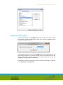
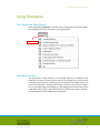
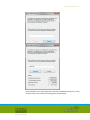
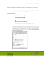
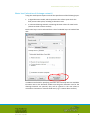
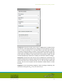
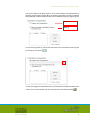
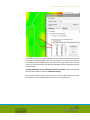
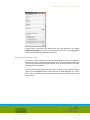
FloodArea and FloodAreaHPC ArcGIS- extension for calculating flooded areas USER MANUAL Version 10.0 – Juli 2011 Content -ii- Content Preface..................................................................................................................1 What FloodArea Can Do For You? ........................................................................2 Installing and Loading FloodArea .........................................................................3 System Requirements ................................................................................................. 3 Installation .................................................................................................................. 3 Demo data and demo ArcMap project ....................................................................... 3 Activating the FloodArea toolbar ................................................................................ 3 Registering your license .............................................................................................. 4 Using FloodArea ...................................................................................................6 The FloodArea Main Menu ......................................................................................... 6 Available memory ....................................................................................................... 6 Calculate flooded areas (inundation zones) .........................................................8 Vorbedingungen.......................................................................................................... 8 Running a simulation .................................................................................................. 9 Water level (elevation of drainage network) ..................................................................................... 10 Hydrograph (input by point locations) .............................................................................................. 13 Rainstorm (input by area).................................................................................................................. 18 Additional settings .................................................................................................... 20 Output options .................................................................................................................................. 21 Calculation options ............................................................................................................................ 21 Metadata........................................................................................................................................... 22 Legend ............................................................................................................................................... 22 Simulation pre-processing and processing ............................................................... 22 Post-Processing ......................................................................................................... 23 Display simulation info / Continue simulation .......................................................... 23 Create / display animation ........................................................................................ 25 Unify legend .............................................................................................................. 28 Summarize grid values .............................................................................................. 28 Create shape of flow direction .................................................................................. 29 Choose language ....................................................................................................... 31 Info ............................................................................................................................ 31 FloodArea Toolbox .............................................................................................33 Background ............................................................................................................... 33 Installation ................................................................................................................ 33 Starting FloodArea .................................................................................................... 34 Command line ........................................................................................................... 34 Notice ........................................................................................................................ 34 Metadata management......................................................................................35 Calculation Method ............................................................................................36 Volume Budget ......................................................................................................... 39 Dam Failure ............................................................................................................... 39 Consideration of Model Edges .................................................................................. 41 Application Examples .........................................................................................42 Delineation of Flooded Areas Based Upon Flood Marks........................................... 42 Dam Failure Scenarios ............................................................................................... 42 Controlled Outlet of Flood Control Basins ................................................................ 42 Limitations................................................................................................................. 42 Demo Version and Demo Data ...........................................................................43 Notice ........................................................................................................................ 43 Data ........................................................................................................................... 43 Version 10.0 – July 2011 ii Content -ii- Using FloodAreaHPC .............................................................................................44 Publications on FloodArea..................................................................................45 Support ...............................................................................................................47 License Agreement .............................................................................................48 Copyright © geomer GmbH / RUIZ RODRIGUEZ+ZEISLER+BLANK, GbR, 2001-2011 ESRI, ArcGIS, ArcView, SpatialAnalyst are registered trademarks of Environmental Systems Research Institute Inc., Windows XP, Windows Vista und Windows 7 are registered trademarks of Microsoft Corporation, Pentium is a registered trademark of Intel Corporation. Version 10.0 – July 2011 iii Preface / System Requirements Preface Floods are natural processes. Urbanization and increasing population density as well as a concentration of economic values in flood prone areas have increased the risk in many regions. Natural flood plains all over the world are being settled or and used for industrial purposes. Perception of the flood hazard and the associated risks in many cases is low, if not inexistent, particularly in such areas considered to be safe, e.g. behind dams or levees. New planning approaches, though, try to counteract these developments and create suitable flood protection concepts. In this process, the delineation of flood prone areas is a very important first step. Additional information in this delineation process is achieved by the calculation of water levels at any given point at different times during a flood event. Such information delivers very important basic data for the determination of the risk potential. In addition the possibility to simulate the temporal dynamics of the flood event produces important information for disaster management plans. FloodArea enables the user to do both types of analysis. This manual explains in detail the application of the software. Relevant examples are being given. The particularities of the computational algorithms are also explained in detail. FloodArea is an ArcGIS extension, which is completely integrated in the graphical user interface of ArcGIS desktop, utilizing Spatial Analyst functionality. No details of ArcGIS or Spatial Analyst are explained here. The user is assumed to be familiar with the use of ArcGIS in general and ArcMap and Spatial Analyst in particular. Reference is given in the respective manuals or via online help. FloodArea is a joint product of geomer GmbH, Heidelberg, Germany, and Ingenieurgemeinschaft Ruiz Rodriguez + Zeisler +Blank, Wiesbaden, Germany. Version 10.0 – July 2011 1 What FloodArea Can Do For You? / System Requirements What FloodArea Can Do For You? The main purpose of FloodArea is the delineation of flooded (inundated) areas. Calculations are based upon a drainage network grid with water levels assigned to it. Though the water levels can vary spatially (e.g. along a river stretch) they remain constant during the simulation process. The water levels can be changed, however, by modifying them between single model runs, or by one or more hydrographs at user definable coordinates, or by a rainstorm simulation over a wider area, specified by a weighted Grid. Model results are stored as Grids at user defined intervals, providing for the possibility to reproduce the temporal aspect of the flooding process. The values of the resulting Grids can be stored as absolute height levels or as values relative to the surface. If needed, the flow direction vectors can be output for each individual grid. Additional parameters can be specified for a simulation run. Flow barriers (e.g. road embankments), which are not represented by the elevation model, can be specified. Locations of dam failures can also be specified determining at which points flow barriers fail, making dike break scenarios possible. To adapt the flow velocities to real world conditions, the user can specify roughness values. Version 10.0 – July 2011 2 Installing and Loading FloodArea / System Requirements Installing and Loading FloodArea System Requirements Minimum requirements are ArcGIS Version 10.x and the Spatial Analyst extension, a Windows XP, Windows Vista or Windows 7 operating system und 2 GB RAM. Recommended are at least 4 GB RAM and 10 GB free disk space. The maximum Grid size for FloodArea depends on free memory. Increasing the virtual memory is not an option because disk swapping will reduce processing speed tremendously. Disk space requirements depend directly on the number of intermediate simulation Grids. Installation The Installation of FloodArea will be accomplished by using the install-setup program FloodArea10Setup.exe. Demo data and demo ArcMap project The installation procedure will install an ArcMap document (mxd-file) with associated data and also this manual. These files will be copied to the user’s UserFolder during the first start of FloodArea. The path of the User-Folder depends on the operating system. Please read additional explanations in the chapter Demoversion und Demo Data, on p. 43. Activating the FloodArea toolbar After installing FloodArea a new toolbar can be activated in the customize dialog by clicking Customize, Customize mode. Version 10.0 – July 2011 3 Installing and Loading FloodArea / Registering your license Registering your license To be able to make full use of FloodArea with your own data you need to register your license. You will be asked to do so after any new start of ArcMap, until a valid license code is entered. If a valid license code is not entered FloodArea can still be used with it’s full functionality. However, it will not be possible to work with data other than the data provided with the demo project. After entering a valid license code, the dialog won’t show up again automatically. The dialog for entering a valid license code can also be activated by using the menu FloodArea, License Number. Version 10.0 – July 2011 4 Installing and Loading FloodArea / Registering your license In the subsequent dialog you can enter or display the license code. Version 10.0 – July 2011 5 Using FloodArea / The FloodArea Main Menu Using FloodArea The FloodArea Main Menu After loading the FloodArea, its toolbar can be used just like any other toolbar. The available sub-menus are shown in the figure below. New Toolbar Available memory Use this option to check whether or not enough memory is available for the simulation. Please note that the given value is an estimate only, since all other running programs and the operating system itself use the available memory in concurrent operations. The given percentage is based on the physical memory only. Try to avoid using virtual memory. In this dialog you can select from a list of raster data layers from the active data frame or load one from disk. In the latter, the selected layer will be added to the data frame. Version 10.0 – July 2011 6 Using FloodArea / Available memory Avoid simulation runs requiring memory above the available real memory. Using virtual memory may increase processing time tremendously. Version 10.0 – July 2011 7 Calculate flooded areas (inundation zones) / Vorbedingungen Calculate flooded areas (inundation zones) This is the core option of FloodArea. Use this menu for hydrodynamic modeling of inundation areas for given water levels (e.g. from a 1D model). Vorbedingungen For calculating inundation areas using FloodArea a minimum of two input raster layers are needed: a digital elevation model and a rasterized drainage network or point(s) with attached hydrograph(s) or a rainstorm distribution raster with attached hydrograph It is recommended to define the map units in the data frame properties. If not set, the unit meters will be assumed. Please be aware, that wrong units will produce wrong flow volumes and velocities, and thus will lead to unusable results. However, map units can be set also later on in the main dialog of FloodArea (Calculation of flooded areas). Version 10.0 – July 2011 8 Calculate flooded areas (inundation zones) / Running a simulation Running a simulation Start the simulation definition by choosing the option Calculate flooded areas from the main dialog: The geographic extent of a model run is defined by the digital elevation model specified in the drop down filed Elevation model. The user has a choice of three variations of simulation. They differ in the way the water is input to the simulation model. Using the option Water level (elevation of drainage network) assumes that flooding is initialized by the entire drainage network, meaning from all grid cells other than NoData). Water levels can vary spatially but remain temporally constant during the simulation process. Using the option Hydrograph (input by individual point locations) water enters the model at defined locations. This option makes a temporal variation (hydrograph) of water levels possible (see below how to specify hydrograph data). The third option Rainstorm (input by a defined area) is very similar to the second one. The difference between the second and the third option is that the water levels are defined by a raster (GRID). Press Cancel to abort the model run. Version 10.0 – July 2011 9 Calculate flooded areas (inundation zones) / Running a simulation Water level (elevation of drainage network) Using this model option requires at least the specification of the following layers: a digital elevation model, which represents the surface upon which the flow process takes place, including its elevation units a rasterized drainage network containing elevation values of water levels (above sea level or above surface) Both raster layers can be selected from a list of available layers or loaded from disk. In addition two fields for specifying elevation units and map units are available. Elevation units or the elevation models must be given. Elevation units for the drainage network are optional; they will be ignored in the case where a calculation is based on a constant flood level (e.g. 1.5 meter above surface). Version 10.0 – July 2011 10 Calculate flooded areas (inundation zones) / Running a simulation D A B C The Water level (flood level elevations) is represented by the values of the input drainage network Grid (box A is checked) . If the water level (flood level elevations) is represented by the values of the input drainage network grid, a constant value (specified in field C) can be added. Boxes A and B must be checked for this method. Elevation units are the same as for the elevation model. It is also possible to specify only a constant value. In this case cell values of the drainage raster will be ignored. In this case checkbox B must be checked, filed C must be empty and checkbox A must not be checked. At least one of the checkboxes A and B must be activated! For all options the water level elevations can represent relative values above the surface (option D, left), or absolute values, e.g. above sea level (option D, right). Before actually starting the model run, the plausibility of the user input is being tested. In case of problems, the user is given some information about possible erroneous input. For example, FloodArea checks for missing or wrong specifications in the various input fields. It also checks for alignment problems between input Grids. Additional optional Grids can be taken into account by clicking on Show optional properties. Version 10.0 – July 2011 11 Calculate flooded areas (inundation zones) / Running a simulation Flow barriers: All grid cells other than 0 (zero) or NODATA are considered to be flow barriers. The model algorithm uses diagonal transfer between grid cells. Thus, in order to function as a true flow barrier, grid cells must be edgeconnected. Grids generated by ArcView’s’ rasterizing of line shape files meet this requirement. No heights of dams can be specified here. If these are available and to be used in the simulation, they must be part of the elevation model. Use the standard SpatialAnalyst functions to modify your elevation model accordingly. Dam failure: All Grid cells other than 0 (zero) or NODATA are considered to be superior to flow barriers. Superior means that at any given location (i.e. grid cell) where both flow barrier and dam failure are set, the dam failure Grid takes priority. You can use this option for the simulation of dam failures or levee breaches. Roughness: A Grid representing roughness values according to Manning. The values have to be given as kSt (= 1/n), in units of m1/3/s. Version 10.0 – July 2011 12 Calculate flooded areas (inundation zones) / Running a simulation Modification: With this option it is possible to raise or lower the complete water level during the simulation process. The ASCII-file to be selected here has to have the same format than the hydrographs used within the other options (see page 14). The values will always be interpreted as the difference to the original water level. The values between the data in the input file will be linearly interpolated The water level defined in the grid drainage network will be lifted or lowered by the value defined for the actual time step. With this function you can simulate, for example, the passage of a flood wave within a bigger river and the effects on the connected retention areas. This selection is not available when the option water level has been chosen in combination with the option hydrograph. Hydrograph (input by point locations) Using this option implies that input for a drainage network with associated water level data is not required and can be ignored. Water is fed into the model through a hydrograph data file at one or more locations. The name of this data file can be entered directly or selected from a file dialog. Path to hydrograph data file Ganglinien-Datei Version 10.0 – July 2011 13 Calculate flooded areas (inundation zones) / Running a simulation The hydrograph data file is simply an ASCII text file that can be created with any text editor. It must have the extension “.txt” and must be organized according to the figure below. 1. Column: Time in hours 2. and further Columns: Discharge in m³/sec 0.00 0.05 0.17 0.33 0.50 0.67 0.83 1.00 To separate the columns the following characters are admitted: empty space, tab, comma, semicolon or colon 20.1 22.8 25.2 24.3 25.3 26.2 23.9 24.8 5.6 5.7 5.8 5.9 5.9 5.8 5.7 5.5 Dezimaltrennzeichen: Punkt The file has at least two columns, one holding the time (in decimal hours), the second and all others holding the discharge (in m³/s). The decimal sign must be a dot; columns may be delimited by a space, a tab stop, a comma, a semicolon or a colon. No empty lines or inline comments are allowed. Comments, though, may be added as separate columns. But they should not contain any numbers. Negative discharge values are valid, although their usage is not recommended. If values are negative, the corresponding amount of water at that point will be interpreted as being taken out from the model. The algorithm does not comply with situations, where the negative value is higher than the amount of water currently available at that particular raster cell. Such assumptions may produce errors in the overall budget. Time steps need not be regular. The program interpolates linearly between the specified time steps. If simulation time (see Additional settings) is reached before all hydrograph data are processed, the model stops. The hydrographs input locations are specified by the input coordinates. The hydrographs are assigned to the input coordinates in the same order as the columns of the coordinate input file. Note that the numbering of the coordinates starts with 0. If either the column or the input coordinate is missing, the corresponding input will be neglected. Version 10.0 – July 2011 14 Calculate flooded areas (inundation zones) / Running a simulation The input coordinate at which water is “fed” to the model are specified either by digitizing new locations (option A) or by loading a previously created coordinate file (option B). Loaded coordinate files can be modified using the digitizing tool. Option A Option B In case of using option A, a file name and location for the new file must be given by clicking on the button . In case of using option B FloodArea will try to load the last loaded coordinate file. If there is no coordinate file, the user can load one from the file dialog Version 10.0 – July 2011 . 15 Calculate flooded areas (inundation zones) / Running a simulation A maximum of 500 point locations can be specified in a coordinate file. Using the buttons add new edit, and delete existing and new points can be managed. With add new , new point locations can directly be digitized in the map layout, the will immediately show on the map. The options edit and delete will only become active after selecting a coordinate from the list. After selecting a point from the list, editing of existing points takes place directly on the map by clicking its new location. Deleting a point from the list must be confirmed. For each location in the input coordinate file, one column with discharge data must be present in the hydrograph data file. The order of the locations in the list must be the same as that of the columns in the hydrograph data file. If there are fewer columns in the hydrograph data file than locations in the coordinate file, that location will be ignored, and vice-versa. Using the checkbox Version 10.0 – July 2011 the locations can be indicated on the map. 16 Calculate flooded areas (inundation zones) / Running a simulation The amount of water leaving the model area at its edges is summed up for each time step of the hydrograph input file and written to an external file with the same name, but with a different file name extension (.out). Volumes are saved in units of m³. Please be aware that already existing files with the same filename will be overwritten. Hydrograph data file and coordinate file must be specified in order to be able to continue the model run with the additional settings. The optional properties are mostly the same as for the option water level, with the exception of the modification file which is of no purpose here. Version 10.0 – July 2011 17 Calculate flooded areas (inundation zones) / Running a simulation Please notice: the model stops either when the time specified in the dialog Additional settings has run out, or when the last record of the hydrograph data file has been processed, whatever comes first. Rainstorm (input by area) This option is almost identical to the one described above, the most important difference being that the hydrograph is not given for one input coordinate but for an area. This area is defined by a grid theme. Thus, only one column in the input data file can be considered. The format of the hydrograph data is the same as above. Values, though, must be given in units of mm/h. Output is calculated for the model edge only. An output file (*.out) is produced in the same way as described above. Values of the output file are in m³. Version 10.0 – July 2011 18 Calculate flooded areas (inundation zones) / Running a simulation Different from the option Hydrograph, instead of coordinates for input/output locations, a grid theme representing the area for the hydrograph data must be chosen. Grid cells containing the value “zero” or “NODATA” are considered to be “dry” cells, i.e. cells without water input. All other values given will be multiplied with the value in the hydrograph data file allowing for a weighted input. If a weighted input is not desired, all values must be set to 1. No negative values should be used. In general the two hydrograph options are the same. Using the areal input with a grid containing only a single cell, the results of the simulation are the same compared to using the normal hydrograph option. But before running the rainstorm option you have to consider the different input units. Pay attention to the fact that the conversion factor depends on the cell size. Here some examples: Version 10.0 – July 2011 19 Calculate flooded areas (inundation zones) / Additional settings An input of 1 m³/sec at a cell size of: 5m*5m 10 m * 10 m 20 m * 20 m 25 m * 25 m 30 m * 30 m 40 m * 40 m 50 m * 50 m 100 m * 100 m is the same as an intensity of: 144 000 mm/h 36 000 mm/h 9 000 mm/h 5 760 mm/h 4 000 mm/h 2 250 mm/h 1 440 mm/h 360 mm/h This conversation will be done automatically if Input hydrograph in m³/sec is switched on. In this case the amount of water described by the hydrograph file will be divided to the cells of the precipitation area raster. Values within the grid will be interpreted as weighting values, the total amount of water remains unchanged. The optional settings equals to the ones of the option Hydrograph. If the option rain storm is combined with the option hydrograph, then the hydrograph of the rainstorm option will be used and a text notice will become visible. Additional settings All simulation methods will be controlled by additional settings. The dialog for these will be activated after clicking the continue button. Version 10.0 – July 2011 20 Calculate flooded areas (inundation zones) / Additional settings A H B I C D J E K F L G Output options Use this dialog to specify a directory (field A) for the temporary grids produced during the model run. Also use this dialog to give a name for the output grids in field B. The name will be completed automatically by a sequence number, i.e. the first grid will be named floodarea1, the second floodarea2 etc.. Please be aware that already existing grids with identical names will be overwritten. ArcGIS rules for grid names and paths must be followed. In the option field C, the model output values can be given in absolute elevation (in most cases this means above sea level) or it may indicate water depth above the surface. In any case the units will be the same as the units chosen for the elevation model. The interval of the time steps (i.e. the interval for which intermediate grids will be saved) can be chosen in field D. One time unit accounts for approximately one hour of time. This value is an estimate because the model is not calibrated. The checkbox Output of flow direction (E) needs to be activated if you want to generate a shape file with the flow direction later on. Please note that this will generate three grids instead of one for each output time step, so provide enough disk space if you intend to use this option Calculation options Simulation period (field F) is the total simulation time (approx.) in hours. If the model run is a continuation of a previous simulation, the simulation time will be extended by the given value. Version 10.0 – July 2011 21 Calculate flooded areas (inundation zones) / Simulation pre-processing and processing The maximum exchange rate (field G) defines the percentage of water volume present in the current grid cell, which is distributable to the neighboring cells. If the given exchange rate is exceeded, the model decreases the internal iteration time step and by this also the exchange rate until the exchange rate will be below the given maximum. As the value influences the time step the value has influence on the simulation speed. If values are high, wave instability can be the result, which will not stop the model but may produce undesirable results. Values between 1 and 5 % have proven to be good choices. To determine the optimal value it is best to run some test. If the resulting water surface is very smooth one may use a larger exchange rate. In flat areas with high flowing velocities (like levee failures) usually values around 1% produce the best results, in steep areas values up to 15% may still produce good results. Metadata In order to save information about the grids produced by model runs, FloodArea makes use of the metadata concept of ArcGIS. Some of the metadata will be saved automatically (e.g. the simulation period), other information can be specified by the user. There is the possibility to give an author name in field Author (field H) and a comment (field I). Legend In this section ArcMap specific legend options for the output raster layers can be specified. NODATA values are set transparent by default. Choose between a classified or continuous smooth legend in option J, and select a color ramp in L. If a classified legend is chosen, the number of classes can be given in field K. The option Generate grouping will create a layer group of the model result grids. The layer group name will be created from the chosen name for their output grid followed by “Group”. The option Calculate will start the simulation run. Simulation pre-processing and processing Prior to the actual simulation run, a python script tool will be executed in order to prepare the data in a format suitable for the actual FloodArea processing core. The temporary grids created during that step will be deleted after thee simulation run. Version 10.0 – July 2011 22 Calculate flooded areas (inundation zones) / Post-Processing After successful completion of the python script-tool the FloodArea simulation run will start automatically. During the simulation run the user will see a window displaying information about the modeling progress. Post-Processing After finishing the simulation run the created intermediate grids will be loaded to the active data frame. Display simulation info / Continue simulation With this dialog you can display information about previous model runs or continue a previous simulation run. The information is stored in the metadata of each model result grid. Version 10.0 – July 2011 23 Calculate flooded areas (inundation zones) / Display simulation info / Continue simulation The information is shown either for a grid layer present in the active view or for a grid stored on disk. In the input section the specifications made for producing the grids will be displayed. In the output section specifications made in the additional setting (see above) are shown. A true means that a specific option was set, some options like Units of Modification cannot be chosen by the user but are displayed for better understanding. In case of a continued simulation the specified simulation duration (see additional settings) is added to the already passed simulation time for that particular grid. If a calculation is continued the program itself is searching for the correct time step in the hydrograph files. The simulation parameters can be changed to continue a simulation with different settings. Version 10.0 – July 2011 24 Calculate flooded areas (inundation zones) / Create / display animation The button load settings will read the specifications previously made for creating the grid to be used here as input for continuing the calculation process. Create / display animation Using this option a better visualization of model simulations can be achieved than using ArcMap. A series of JPG images and an additional animation in AVI format can be produced with FloodArea. Version 10.0 – July 2011 25 Calculate flooded areas (inundation zones) / Create / display animation A2 A1 C1 B C2 F D G H E Raster layers to be included in an animation are managed in two lists (A1 and A2). Here, layers can be moved (buttons B), added or deleted from the lists (buttons C). In the right list it is possible to modify the order in which the images will be created. Modify the list with the up and down buttons or reverse the list with . Multiple selections are possible in both lists by pressing the Altand/or Ctrl-Key. The lists (A1 and A2) will only contain FloodArea layers. Other layers in the data frame will be displayed according to their visibility status automatically. Thus, if you want a particular map background, switch on or off the layers you need. The list of FloodArea-Layers appears in reversed order when compared to ArcMap layer ordering. The reason is, that for creating the animation the last entry in the list have to be exported as the last image. Specify JPG quality and resolution, and AVI speed (frames per second) in fields D. In field E the output name and directory for the images and movies can be defined. Version 10.0 – July 2011 26 Calculate flooded areas (inundation zones) / Create / display animation With button F, the option to include the simulation time of each individual raster layer in the image or movie is given. The time will be read from the metadata associated with each grid. If a movie is to be produced, this option will generate the effect of a clock. Pressing button G will start the creation of JPG images without producing an avimovie. Pressing button H must be clicked for starting the creation of an animated movie. It can only be activated if the jpg images already exist. Various compression options (codecs) can be chosen in the following dialog. Use your favorite video player software for showing the animated simulation. Version 10.0 – July 2011 27 Calculate flooded areas (inundation zones) / Unify legend Unify legend Use this option to assign an identical symbology legend to selected grids. This is especially useful when results of different simulation runs are to be compared or displayed. A B First, in the left list (A) select the FloodArea layers (or other raster layers) which should have the same legend, then select in the right dropdown box (B) the raster layer with the desired symbology to be used as a template for all others. Summarize grid values All values of the active grid theme are being summarized using this function. Given the case that for instance the flooding depth is given and horizontal and vertical units are identical, the present total volume of water will be shown. Thus, reliable volume balancing can be realized. Version 10.0 – July 2011 28 Calculate flooded areas (inundation zones) / Create shape of flow direction Create shape of flow direction By using this menu option it is possible to generate a shape showing the direction of flow. To create such a shape you have to select two grids, one representing flow direction, and one representing discharge or velocity. These grids can be produced during the model run by checking this option in the additional settings. The grids can be loaded from disk if they are not already loaded in the current data frame. If the arrows showing the direction are displayed too large or small, this may be caused by the missing or wrong unit input within the data frame properties. Please refer to your ArcMap manual. The arrows are set to scale 1:1000 to correspond to the demo data. Version 10.0 – July 2011 29 Calculate flooded areas (inundation zones) / Create shape of flow direction For presenting the flow direction 16 directions can be shown, according to the internal relation of raster cells in FloodArea. This will produce a uniform flow direction picture. It must be considered that flow directions are snapshots of a dynamic process. Particularly in terrain with rapidly changing flow direction it is best to output several situations. Version 10.0 – July 2011 30 Calculate flooded areas (inundation zones) / Choose language Choose language FloodArea offers the possibility to choose the language used for the dialogs, the help texts and the messages displayed during the model run. Currently available are German, English, Spanish, and Hungarian the default is German. Use OK to switch to the chosen language. You do not have to restart the program or reload the extension. Info Use the Info button to display the version number, license number and service addresses. Version 10.0 – July 2011 31 Calculate flooded areas (inundation zones) / Info Version 10.0 – July 2011 32 FloodArea Toolbox / Background FloodArea Toolbox Background Some users of FloodArea requested an option to integrate the FloodArea functionality in a batch process. For computing sequences like different recurrence intervals or different dike failures it is helpful to set up a sequence of simulations and start those in batch mode without having to use the interactive user interface. Installation The toolbox installation takes place while installing the FloodArea extension. The toolbox will be installed in the same folder (see page 3). Use the regular ArcGIS Desktop method for loading the Toolbox. Version 10.0 – July 2011 33 FloodArea Toolbox / Starting FloodArea Starting FloodArea All possibilities available for script tools can be used to start a FloodArea simulation run. In the tool dialog all parameters as described for the regular interactive user dialog can be specified. Use the tool help for reference. Command line The usual rules for script tools apply. Notice The batch version of FloodArea does not support all the different internal checks of the normal desktop version so the user needs to make sure that the input data are in the appropriate format. These comprise: Version 10.0 – July 2011 34 Metadata management / Notice All input grids of one simulation should have the same extent and resolution Grid names should be conform to the Spatial Analyst requirement (no special characters, not more than 100 characters in path/file name, not more than 12 characters in file name) Hydrograph files must have the extension “.txt” Hydrograph files and coordinate files must have the appropriate structure and use the “.” as a decimal delimiter Metadata management FloodArea makes use of the metadata concept of ArcGIS for storing information about utilized input data and produced model results. The XML definitions of the ISO standard have been extended with specific FloodArea elements. Additional Metadata can be added without losing the FloodArea elements. Version 10.0 – July 2011 35 Calculation Method / Notice Calculation Method The calculation of inundation areas is based upon a hydrodynamic approach. All eight neighbors of a raster cell are considered. The discharge volume to the neighboring cells is calculated using the Manning-Strickler formula. V kSt rhy2 / 3 I 1 / 2 , with rhy being the hydraulic radius and I the gradient. For looking up appropriate values of k St (roughness) reference tables can be used, which renders the use of this formula more practicable compared to others. The quality of simulation results depends very much on using appropriate roughness values since flow velocity is linearly related to roughness. The flow depth during an iteration interval is taken from the difference between water level and maximum terrain elevation along the flow path. flow _ depth water _ level a max elevation a , elevation b The inclination and the direction of the water table is re-calculated in every iteration step and the steepest slope used as the inclination in the ManningStrickler formula. z z x y 2 slope = aspect = 270 2 z z 360 a tan 2 , 2 y x In cases of linear elements with a width of just one raster cell, this method will fail, because the steepest slope may be perpendicular to the actual direction of flow. This is the case when the inclination of the river bed (e.g. in a small ditch) is lower than the surrounding topography. To avoid such errors, slope calculations are internally tested for their plausibility by comparing the elevation of the central raster cell to the elevation cell of the slope direction (aspect). If the difference is exceeding a certain threshold, inclination is re-calculated by comparing it with the lowest neighboring cell. Version 10.0 – July 2011 36 Calculation Method / Notice For illustration purposes examine the simplified elevation model shown below, depicting a ditch, which has an inclination lower than the surrounding terrain. 79.0 79.0 79.0 79.0 79.0 79.0 78.0 78.0 78.0 78.0 78.0 78.0 72.9 73.0 73.1 73.2 73.3 73.4 75.0 75.0 75.0 75.0 75.0 75.0 74.0 74.0 74.0 74.0 74.0 74.0 Slope direction derived by standard GIS Spatial Analyst. In the line of the ditch, slope values are wrong: Slope direction values in the ditch, as derived by FloodArea: Flow velocity as derived by the formula is multiplied by the flow cross section and the iteration time step in order to get the exchanged water volume between cells for the current iteration. The Manning-Strickler formula is usually valid only for normal discharge, where loss due to friction equals the gain in potential energy. In other cases calculated velocities values may be too high. To control this, the velocity values are checked for the threshold criterion: threshold criterion V Version 10.0 – July 2011 g h 37 Calculation Method / Notice Together with the volume also the velocity vectors are passed for the next iteration. Mean flow velocity is defined as the arithmetic mean of the current velocity calculation and the vector addition. By this, sudden changes in flow behavior will be minimized and inertia effects rendered in a simplified way. The smallest iteration time step is adjusted dynamically. An important control criterion for this adjustment is the amount of water available. If the discharge rates become too large compared with the available volume, the iteration time step will be reduced. Only water level changes exceeding 1mm are considered by that control mechanism. If the volumes exchanged between cells are very small, the algorithm will increase the iteration time step. This permanent optimization keeps processing time at a minimum. calculation of Δ t start actual Δ t calculation of V Vakt > Vmax extension of Δt yes V max = threshold no no calculation of Δ water level reduction of Δt Version 10.0 – July 2011 Δ wl > threshold yes 38 Calculation Method / Volume Budget Volume Budget At the end of each iteration the computed discharge volumes are shifted between cells, thus no volume can be lost. To feed water to the model the three options drainage network or hydrograph rain storm are available. Using the first option, the algorithm sets all cells of the initializing network back to their original values after each iteration. Using the second option the amount of water fed to the model is defined by the hydrograph. The amount of water taken out from the model is specified by selecting an output location. Using the rain storm option „pours“ water over the terrain with a temporal distribution defined by a file. Spatially the distribution is defined by a grid representing the portion at each cell location. A value of 1 is equal to 100%. Dam Failure In terms of a dam failure grid not only potential physical obstacles must be „broken“, but also appropriate flow depth values must be calculated. The assumption made is, that the lowest elevation in the area covered by the dam failure grid (red area) is the local elevation minimum. If water reaches that area, the elevation at that location will be reduced to that local minimum. If, during the simulation, an even lower elevation is detected, it will be considered as the new local minimum and will be applied also to the already flooded cells. Version 10.0 – July 2011 39 Calculation Method / Dam Failure The figures show, in a schematic way, characteristic intermediate phases during a dam failure simulation. From figure 2 onwards, a reduction of the elevation values takes place, being one cell “ahead” of the water level (shown as a horizontal plane for simplification). From figure 4 onwards, the new, even lower minimum is applied also to the cells processed before. Figure 5 shows the final status. Version 10.0 – July 2011 40 Calculation Method / Consideration of Model Edges Consideration of Model Edges Considering the edges of a model area may cause a problem because no information is available for the area beyond the study area. FloodArea assumes a continuing gradient of the water surface beyond the edge of the model. Based upon this assumption, the water is being taken out of the model according to the discharge volumes calculated. A piling up at the model edges is not possible. If the model run is controlled by a hydrograph data file, the water volume taken out at the model edges is written to a separate file named “*.out”, “*” being the name of the hydrograph data file. The volume is specified in m³ since the last time step in the input hydrograph. If a high temporal resolution is desired, this needs to be accounted for in the hydrograph data file. No “*.out” file is created for the option “water level”. Since no defined water volume is fed into the model, an output hydrograph would be meaningless. Version 10.0 – July 2011 41 Application Examples / Delineation of Flooded Areas Based Upon Flood Marks Application Examples Delineation of Flooded Areas Based Upon Flood Marks Quite often historical floods are only registered at individual locations but not to their overall extent. The levels taken from these locations can be used to run FloodArea. The simulation model uses these points (or lines) as initializing cells to flood the surrounding terrain. Elevation differences are interpolated appropriately in terms of the hydraulic model. Dam Failure Scenarios Two possible scenarios can be modeled. The first describes a complete failure of a dam or a section of a dam. Using the option Water level (elevation of drainage network) it is assumed, that the dam failure will not influence the water level of the main stream. The second possibility describes a scenario with a defined inflow into the protected area (to one or more cells) using a hydrograph. Controlled Outlet of Flood Control Basins Given the case that controlled outlet of a flood control basin is necessary, a flooding of other areas might occur. These areas can be delineated by using the design hydrograph data for that particular location. Limitations FloodArea is primarily intended to calculate areas affected by a flood. Essentially it is a simplified two-dimensional hydraulic model, integrated in a GIS. The simplifications made mainly affect the open channel hydraulics, which can be described only roughly with the available parameters (resolution of the elevation model in the channel, no cross sections). Furthermore the algorithms do not contain the impulse transfer, therefore some phenomena such as the sloping of a water level in a river bend is not described correctly. Version 10.0 – July 2011 42 Demo Version and Demo Data / Notice Demo Version and Demo Data Notice The demo version is functional only when using the demo data that comes with it. Data The demo data comprises of: elevation: an elevation model (units are meters) with a horizontal resolution of 5 m, 200 rows and 200 columns, corresponding to an area of 1 km². drainage: a grid representing a drainage network, values represent water levels and are given in meters. rail: a grid representing flow barriers with interruptions, for example bridges in a railway dam. dam : an uninterrupted flow barrier. failure: a grid representing a failure area (adapted to the dam grid). manning: a grid representing roughness coefficients (values are in 1/n). rain: a grid representing weight factors for the option rainstorm (areal input). A hydrograph data file (hydrograph.txt). Version 10.0 – July 2011 43 Using FloodAreaHPC / Data Using FloodAreaHPC FloodAreaHPC is the next generation of FloodArea running on High Performance Computing Clusters comprising of many individual computers but acting as one large computing array. Use FloodAreaHPC for very large study areas with high resolution DEMs (e.g. from LIDAR), and to reduce computing time tremendously. The chapter on using FloodAreaHPC is available only to licensees of FloodAreaHPC. Ask for an individual offer! Version 10.0 – July 2011 44 Publications on FloodArea / Data Publications on FloodArea Version 10.0 – July 2011 Assmann, A., Krischke, M., Höppner, E. (2009): Risk maps of torrential rainstorms. In: Samuels, P., Huntington, S., Allsop, W., Harrop, J. (Hrsg.) (2009) Flood Risk Management: Research and Practice: 48. ISBN 978-0415-48507-4. Holzhauer, V., Müller, M., Assmann, A. (2009): RISK-EOS flood risk analysis service for Europe. In: Samuels, P., Huntington, S., Allsop, W., Harrop, J. (Hrsg.) (2009) Flood Risk Management: Research and Practice: 46. ISBN 978-0-415-48507-4. Assmann, A. (2008) Einsatzgebiete und Erstellung von StarkregenGefahrenkarten. In: Strobl, J., Blaschke, T. & Griesebner, G. (Hrsg.) (2008) Angewandte Geoinformatik 2007, Beiträge zum 20. AGITSymposium Salzburg: 750-755. ISBN 978-3-87907-464-8. Assmann, A. (2007) Starkregen-Gefahrenkarten und Schutzkonzepte. In: Verband Region Rhein-Neckar (Hrsg.) 5. Hochwasserschutzforum Rhein-Neckar, Heft 4. Assmann, A. & Herrmann, S. (2007) Geoinformationstechnologien als Instrument in Beteiligungsprozessen - Anforderungen und Möglichkeiten. In: Kuratorium für Technik und Bauwesen in der Landwirtschaft e.V. (Hrsg.) Geoinformationstechnologien zur Umsetzung der Wasserrahmenrichtlinie. KTBL-Heft 62: 16-30. ISBN 978-3-939371-36-6. Assmann, A. Schroeder, M. & Hristov, M. (2007) High Performance Computing für die rasterbasierte Modellierung. In: Strobl, J., Blaschke, T. & Griesebner, G. (Hrsg.) (2007) Angewandte Geoinformatik 2007, Beiträge zum 19. AGIT-Symposium Salzburg: 19-24. ISBN 978-3-87907451-8. Assmann, A., Grafe, M., Runge, I. & Thäger, F. (2006): Einflüsse des Berechungsverfahrens und der Qualität der Grundlagendaten auf die Ermittelung überschwemmungsgefährdeter Gebiete. In: Hydrologie und Wasserbewirtschaftung 50, H. 1: 19-24. ISSN 1439-1783. Assmann, A. (2005): Simulation von Überflutungsflächen und Deichbrüchen auf der Grundlage von Rasterdaten. In: Wittmann, J. und Xuan Thinh, N. (Hrsg.) (2005) - Simulation in den Umwelt- und Geowissenschaften, S. 109-116. Assmann, A. & Jäger, S. (2003): GIS-Einsatz im Hochwassermanagment. In: Strobl, J., Blaschke, T. & Griesebner, G. (Hrsg.) (2003) - Angewandte Geographische Informationsverarbeitung XV, Beiträge zum AGITSymposium Salzburg 2003, S. 7-14. Assmann, A. (2003): GIS Einsatz bei der Planung dezentraler Hochwasserschutzmaßnahmen. - arcaktuell 1/2003: 28-29. 45 Publications on FloodArea / Data Version 10.0 – July 2011 Assmann, A. & E. Ruiz Rodriguez (2002): Modellierung im GIS Erfahrungen beim Einsatz eines rasterbasierten Modells für Überschwemmungssimulationen. - GeoBIT 7/2002: 14-16. Disse, M, Kamrath, P., Wilhelmi, J. und Köngeter, J. (2003): Simulation des Hochwasserwellenablaufes und der Ausbreitung von Überflutungsflächen unter Berücksichtigung von Deichbrüchen. Wasserwirtschaft 5/2003: 24-29 Disse, M. & Assmann, A. (2003): Bestimmung der Überflutungsflächen infolge von Deichbrüchen mit GIS-basierten Werkzeugen. - Hydrologie und Wasserbewirtschaftung 47, H.6: 228-233. Disse, M., Grätz D. & M. Hammer (2002):Auswirkungen von Deichbrüchen auf den Wellenablauf und die betroffenen Überflutungsflächen am Beispiel des Niederrheins. - 3. Forum Katastrophenvorsorge. Disse, M., Hammer, M. & J. Wilhelmi (2003): Quantifizierung der Hochwassergefährdung für die Rheinanlieger unter Berücksichtigung von Deichversagen. - 4. Forum Katastrophenvorsorge. Disse, M., Hammer,M., Merz, B., Thieken, A. & G. Blöschl (?):Vorsorgender Hochwasserschutz im Rheingebiet - welchen Beitrag leistet das DFNK? - Ergebnisse aus dem Deutschen Forschungsnetz Naturkatastrophen. Jäger, S. (2002): Ein neuer Rheinatlas - Hydrodynamische Modellierung für eine bessere Hochwasservorsorge. - arcaktuell 2/2002: 38-39. Gemmer, M. (2003): GIS/RS-Based Flood Risk Mapping for the Eastern Honghu Flood Diversion Area. - Journal of Lake Sciences 15: 166-172. Gemmer, M. (2003): Transferability of European Flood Impact Estimation Techniques to the Yangtze River Catchment and Possible Adaptations. - Journal of Lake Sciences 15: 173-183. Ruiz Rodriguez, E., Zeisler, P. & A. Assmann (2003): GIS-Einsatz zur Gefahrenabwehr im Hochwasserfall. - Hochwasserschutz und Katastrophenmanagment 4/03: 28-30. 46 Support / Data Support Support is given at the following address, according to your license agreement. geomer GmbH Im Breitspiel 11 B D-69126 Heidelberg Germany Fon: Fax: eMail: Internet: Version 10.0 – July 2011 +49 (0)6221 89458-0 +49 (0)6221 89458-79 [email protected] www.geomer.de 47 License Agreement / Data License Agreement Please read the following license terms prior to installing our software. By installing the software you irrevocably accept this License Agreement. § 1 Subject of the Contract 1. The following terms apply to software licenses granted by geomer GmbH (hereinafter called geomer). 2. Software in the sense of this GTB license includes data processing programs with or without accompanying software protection, data stocks or/and accompanying documentation in machine-readable and printed form, hereinafter referred to as licensed software. Licensed software also includes all copies made of this licensed software in its supplied or modified version. 3. We expressly point out that it is not possible with today's technology to rule out any errors in data processing programs under all application conditions. § 2 Scope of the License, Rights of Use 1. The licensed software is protected by copyright; protection by other legal provisions remains unaffected. 2. In accordance with the type of license purchased, geomer grants the licensee a non-transferable and non-exclusive right to simultaneous use of the licensed software in line with the number and functions agreed. The type of license defines the rights of use. There is a demo license (restricted use exclusively for test purposes) and a commercial license (unrestricted rights of use). If breach of the license terms is proven, twofold license fees are payable for wrongful use of the software licenses. 3. The right of use accrues on delivery of the licensed software. The licensee is entitled to use the licensed software for an unlimited period of time. 4. As per this GTB license, use includes copying the machine-readable licensed software permanently or temporarily, completely or in part, by loading, displaying, playing, transferring or saving it in order to process the instructions and data contained in it on appropriate hardware or to monitor, examine or test the program functions it includes. 5. The licensee is entitled to make a backup copy of the machine-readable licensed software, provided there is a need to do so. If the hardware on which the software has been installed is not operational, temporary use on different hardware is permitted. 6. The right of use does not include the right beyond the scope defined in §2. Clause 5 to copy the licensed software completely or in part, transfer or pass it on to third parties, disseminate it in any other way or grant licenses or sub-licenses to it. Third parties within the meaning of this Agreement are persons not employed by the licensee. § 3 Rights of Ownership and Secrecy 1. The rights to the licensed software, including the licensed software modified or copied by the licensee, remain with the holder of the right mentioned in the licensed software. 2. The copyright notes made by the holder of the right and contained in the delivered version of the machine-readable licensed software and its data carriers should be attached by the licensee to all copies of the machine-readable licensed software and its data carriers. 3. The licensor/copyright owner must be mentioned in all reports and publications concerning the application of the licensed software. 4. The licensee shall not make available the licensed software, including the copies made of it, to third parties for an unrestricted length of time, unless they are using the licensed software at the licensee's premises. The licensee undertakes to make his/her employees who are granted access to the licensed software aware of these terms and to put them under the same obligation as he/she is personally subject to. 5. The licensee shall delete any licensed software contained on any agreed hardware or other hardware or data carriers prior to giving it away or disposing of it. § 4 Performance 1. geomer fulfills its obligations to deliver the goods by handing over the data carriers with the machine-readable licensed software and, if available, the printed licensed software. 2. On dispatch, the risk passes to the licensee when the goods are transferred to the first carrier. § 5 Warranty 1. When delivering the licensed software to the licensee it is warranted that the programs have been thoroughly checked prior to delivery and are in line with the valid program specifications delivered to the licensee. However, geomer makes no warranty that the licensed software is without flaws for any specific instance of application. The responsibility for selecting and using the licensed software for any specific instance of application and the results achieved by it lies solely with the licensee. 2. The warranty does not cover defects caused by improper use of the licensed software. Version 10.0 – July 2011 48 License Agreement / Data § 6 Liability 1. geomer is not liable for damage caused by slight negligence. They are, however, liable for immediate damage caused by slightly negligent breach of significant contractual duties. 3. geomer is not liable for down times, damage and consequential damage caused by program errors, improper use of the licensed software or misinterpretation of the calculated results, regardless of the grounds to which they can be attributed. 4. The licensee is obliged to indemnify geomer against liability for all claims by third parties arising from the use of the licensed software. 5. Otherwise, the damages to be paid by geomer are limited to the agreed license fee and their applicability lapses after 6 months. § 7 Industrial Property Rights and Copyrights of Third Parties 1. geomer indemnifies the licensee against all claims by third parties made against him in the Federal Republic of Germany due to infringement of property rights by use of the licensed software in line with the contract, as long as the licensee has immediately notified geomer of such claims in writing and all protective measures and settlement negotiations are left to geomer. If such claims have been exercised or are anticipated, geomer can modify or replace the licensed material at the licensee's expense. 2. The provision as per § 7 Clause 1 does not apply, if claims of a third party can be attributed to the licensee modifying the licensed software. § 8 Miscellaneous 1. The place of jurisdiction for all disputes occurring due to and in the context of this Agreement is Heidelberg. 2. Should a provision of these General Terms of Business be or become null and void or anything be lacking, the validity of the remainder of the provisions remains unaffected. The parties to the Agreement agree to replace the invalid provision or make good the lack by means of a valid regulation which meets the economically desired purpose of the invalid provision as ideally as possible. Heidelberg, July 2011 geomer GmbH Version 10.0 – July 2011 49