1
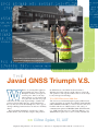
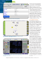
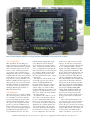
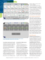
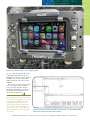
On Broadway in downtown Nashville, with the
famous Ryman Auditorium in the background.
THE
Javad GNSS Triumph V.S.
hile I’ve been using GPS equipment
professionally since 1997, seeing the
Triumph V.S. GNSS system gave me
reason to pause. Gone are the days
when setting up a receiver in the field
was a job better suited for two people
rather than one. The work of Javad Ashjaee, founder and
president of Javad GNSS, has once again revolutionized
the way surveyors work. The Triumph V.S. is not a copy of
existing technology–from form factor to software it definitely
all new.
The Javad GNSS Triumph V.S. is marketed as “Three
Products in One,” but in actuality comprises four products:
the GNSS Receiver, the GNSS Geodetic Antenna, a
Windows-based data collector, and the software to run it all.
The “products” work together without cables, in itself a major
beauty of integrated technology.
V.S. GNSS Receiver/Add-Ons
The V.S. boasts a 216-channel triple-frequency GNSS board
capable of tracking any and all current GNSS signals including
GPS, GLONASS and Galileo, as well as any foreseeable ones.
Packed in with the core GNSS board is a wide variety of
communication options: GSM/GPRS (think AT&T/T-mobile,
etc.), UHF (transmit and receive), Bluetooth, Ethernet, even
WiFi. Firmware updates for receivers are fairly common and
>> Clifton Ogden, EI, LSIT
Displayed with permission • The American Surveyor • Vol. 8 No. 6 • Copyright 2011 Cheves Media • www.Amerisurv.com
for most of us it means getting all the
receivers together and hitching them
up to a PC one at a time for updating.
With the V.S. there is a better way.
Firmware and software updates are
performed via the Internet (over GSM,
WiFi or Ethernet) on the unit itself with
a couple of clicks. No PC required!
But Javad didn’t stop there. He added
two (yes, two) 3-megapixel cameras–
one downward facing and one forward
facing–a digital compass, a multi-axis
inclinometer (to sense and measure the
unit’s angle from level) and expandable
MicroSD slot (4GB card included
with the unit, supports up to 32GB) to
hold all the GNSS data, images, sound
recordings you will need to store.
A V.S. software upgrade is just a few screen taps away.
The map view screen provides icons for positional data as well as
if a voice memo or photograph was taken.
The “Action” Screen provides extensive status and positioning
information in one view.
V.S. GNSS Antenna
The Triumph V.S. Antenna is a
stacked microstrip multipatch model
that supports GPS, GLONASS and
Galileo. The antenna is very similar
to the Javad GrAnt. Unless you plan
on using the V.S. as a CORS station,
you simply won’t need another
antenna. And if you are like me, and
use OPUS to process data from time
to time, rest assured that the V.S.
antenna has been calibrated by NGS
(see www.ngs.noaa.gov/ANTCAL).
The only downside I could find
in regards to the antenna is that I
couldn’t pick up my favorite XM
station, Willie’s Roadhouse.
The pole mounting options for
the V.S. are many. You can use a
conventional 5/8” rover rod, tripod
(with 5/8” coarse thread), or a 1/4”-20
threaded monopod (included with the
V.S. as a standard accessory). Mounting
can be performed either eccentrically
or in any of the three offset attachment
points. If you use an offset attachment
point, you simply set the options in the
V.S. so that it will adjust the position
to eccentric using the compass and
clinometers. You also have the option
of using the bottom camera to center
the V.S. over a point visually (and of
course snap an image at the same time
as you collect the point). This use of a
graduated monopod is a new idea from
Javad. Because you don’t need a level
bubble (the V.S. clinometers take care
of that), monopod use is a convenient
and simple option. Monopod is also
in context to those passers-by that ask,
“Are you taking my picture?” With the
V.S. you can reply, “Yes, as a matter of
fact, I am!”
Displayed with permission • The American Surveyor • Vol. 8 No. 6 • Copyright 2011 Cheves Media • www.Amerisurv.com
Even in a high multipath evironment, the V.S. quickly fixes and provides a very good precision solution.
V.S. Controller
More than likely, the first thing you
notice about the V.S. is the LCD screen.
While most controllers utilize a 320x240
pixel or 640x480 pixel screen, the V.S.
boasts a “wide” 800x480 pixel touchscreen that is easily readable in direct
sunlight. Not only is the screen a higher
resolution than any other survey controller that I have seen, it is also physically
larger than the average controller screen.
With its colorful icons and single-screen
main menu the V.S. user interface looks
much like an iPhone or Android home
screen, however the operating system
running behind the Javad software is
Microsoft Windows CE.
V.S. Software
The V.S. software is a complete GNSS
data collection package that runs on the
V.S. controller. I was able to quickly
get up and running on our local VRS
network with the unit. Quick setup is
due in part to the single-screen menu
layout as well as the workflow-based
instructional videos posted on Javad’s
website (www.javad.com/jgnss/support/
JavadVideoLessons.html) narrated
by Javad himself. The V.S. also has a
built-in manual. Simply click on the
“User Manual” icon on the home
screen and you are presented with a
choice of Tutorials and How Tos that
cover everything from connecting the
unit to the Internet to transferring data
to a computer. Online support from
Javad Technicians is also accessible
directly from the unit–it’s like “texting”
tech support!
The software contains all the tools
one would expect in data collector
software including COGO and
linework editing. The basic software
functions operate similarly to other
software I have used such as TDS,
Carlson, SMI, Topcon and others, but
getting to a specific function seems to
take fewer “clicks” due to the shallow
V.S. menu structure.
In addition to the touch screen, the
device has several hardware buttons
to access common functions (such as
home screen and action/collect data
screen) with one push of a button. In
addition to the common buttons, the
V.S. has five hardware (F) keys that
assist with quick navigation. Rumor
has it that these keys may eventually
be user configurable, but at the time
of this review, with version 1.5 of the
software, the buttons are hardcoded.
The storage for all data collected with
the V.S. is handled within a database
organized by Maps. Think of V.S. Maps
a being synonymous with job files. On
the V.S., Maps contain all the points, raw
GNSS data, images, sound files associated with a specific job. This allows for
cohesive organization of all the project
data which simplifies data download and
storage both on and off the unit. Data
management on the desktop is handled
with a free application called JustinLink
which allows export to several common
data formats including ESRI, KML
(Google Earth), DXF and ASCII text.
Along with common elements, the
V.S. has some unique features in the
software that are made possible because
of the specific hardware contained in
the V.S.:
“Lift and Tilt” Mode In this mode, the
V.S. waits to become near level and then
begins collecting data. I say near level,
because the V.S. can correct for not being
level using the internal inclinometers and
compass. This mode if very useful if you
are surveying several similar features
(such as a break line) as you can set the
Displayed with permission • The American Surveyor • Vol. 8 No. 6 • Copyright 2011 Cheves Media • www.Amerisurv.com
solution. Simply put, male or female,
you want a six-pack.
Data Calendar Do you want to go
back to a specific day and see what data
was collected with the V.S.? Go to the
calendar and you will be presented with
a view of a calendar with icons showing
data collected on the given day.
Audio Guidance Tired of looking at a
display for stakeouts? The V.S. has an
audio guidance feature that gives you
a nice “left, right, forward, backward”
voice feedback system. Read a magazine, stakeout; text a friend, stakeout.
V.S. Function in the Field
Because of its large screen, V.S. menus are presented more like a buffet.
In all seriousness, all the bells and
whistles don’t mean jack scratch if the
gear doesn’t perform in the field. While
I may be able to use the unit effectively,
I try to spend my day playing golf and
trying to solve the Federal budget crisis,
so the real test was to put the unit in
the hands of one of our die-hard survey
crews. To validate the unit I replaced one
of our crews’ existing GNSS receivers
with the V.S. While they did seem to
notice the change immediately, we spent
the next hour going through the basic
initialization and point survey functions
of the unit. The unit was a moderate
change from the data collectors running
another software package they are used
to, but they quickly got the relation of
the V.S. menus to that on their existing
software and into the field they went.
Final Thoughts
The “Six Pack” Status Screen shows the precision of each solution
and the weighted percentage given to each solution.
V.S. with the descriptor and move from
point to point and never have to touch
a button to start and stop the point data
collection. By default the V.S. will begin
collection when the unit is within 5
degrees of level and stop when greater
than 15 degrees from level. (This is
great, just make sure your survey crew
knows what level is.)
Spectrum Analysis With all the concern
of LightSquared and other terrestrial
interference that affects the GPS signal,
wouldn’t it be cool to have a spectrum
analyzer to check out what is broadcasting in-band with GPS? If you are as
geeked-out as I am and agree, the V.S.
has your desire covered. With spectrum
analysis function built in, you can
view interference analysis directly
on the V.S. screen.
Time for a six-pack? Maybe not
exactly what you had in mind, but
Javad has come up with a very
versatile engine for handling RTK
solutions. If you have used RTK for
any time at all, you know there is
potential for a bad initialization and
therefore a bad fix to occur. The Javad
Six Pack RTK V6 Engine mitigates
bad initialization by simultaneously
generating six separate solutions and
weighting them accordingly. Not only
does this help mitigate bad fixes,
it provides a more accurate RTK
We utilized the three V.S. units we were
provided by Javad GNSS in both a
base-rover configuration and on a VRS
network. We used the V.S. to set survey
control, stakeout, GIS data collection–
performance, productivity and usability
was stellar. I was greatly impressed
by the RTK performance in heavy
multipath environments, specifically in
downtown Nashville. Being able to snap
a picture and record a linked audio comment about a shot was a nice feature that
we enjoyed using. I utilized the ability in
the V.S. to create a data dictionary with
pick lists, which worked well for GIS
data collection, however when using
very long predefined code lists, I would
like to see an auto-complete function
instead of having to page through a code
list. It would also be beneficial to have an
ASCII export function within the V.S. to
allow simple point data to be transmitted
via Bluetooth to another data collector
in the field without using JustinLink
Displayed with permission • The American Surveyor • Vol. 8 No. 6 • Copyright 2011 Cheves Media • www.Amerisurv.com
Even in full sunlight, the V.S. screen is highly readable.
(or even e-mail directly from the device
in the field). Considering the speed at
which the V.S. software is being updated
(monthly), these features may even be
implemented by the time this review is
published.
The V.S. is truly unique and performs
very well on paper and in the field.
It was a pleasure using the units in a
production environment–so much so
that perhaps the manufacturer won’t
ask for the test units back!
Clifton Ogden, EI, is a Vice President
with Nashville-based Civic Engineering
& Information Technologies, Inc., and
is a graduate of Auburn University
(Engineering) and the University of
Wyoming (Surveying). He gained his
LSIT in the Fall of 2010 and plans to
sit for his LS in 2012. Mr. Ogden has
been working in the surveying industry
since 1989.
JustinLink, the office software included free with the V.S., is used to import/export
and translate data, photos and audio recordings
Displayed with permission • The American Surveyor • Vol. 8 No. 6 • Copyright 2011 Cheves Media • www.Amerisurv.com