1
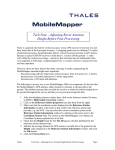
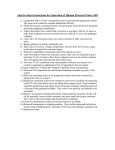
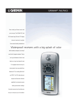
ProductReview
By Al Pepling, LS
Al Pepling works for Trans Associates in Pittsburgh.
He is licensed as a professional land surveyor in
Pennsylvania, as a professional planner in New
Jersey, and is a past president of the New Jersey
Society of Professional Land Surveyors (NJSPLS).
MobileMapper by Thales Navigation
n the tradition of the Locus and and mapping consumers. Mobilethe ProMark2 from Thales
Mapper comes with MobileMapper
Navigation, (formerly Ashtech), Office and MobileMapper Transfer softthe MobileMapper is primarily
ware to give the purchaser a complete
intended to be used for GIS
solution. The trial box that I received
data capture, and it has great
included data transfer cables as well as
navigation features as well. The addition- batteries.
al capability of receiving the Wide Area
MobileMapper will track up to 12
Augmentation System (WAAS) correcsatellites with its 12 parallel-channel techtors make the MobileMapper more than
nology. It has a quadrifilar antenna,
capable for doing GIS work.
which I will leave up to the electronic
To some practitioners, the mention of
engineers to explain, but like a total staGIS evokes disparaging comments. If
tion or GPS, I do not need to know how
yours are among them, please read a litto design one to learn to use it effectivetle further. Land surveyors have been
ly. It does do the job. In daily use it
doing GIS data capture
will begin tracking satellites in
and cartography since
approximately 15 seconds and
the inception of land
updates the screen every secsurveying. Don’t forond. Off the shelf it takes
get that in the early
about a minute or so to get
days of this country,
acclimated to its position
surveyors also acted
and begin tracking
as title people, realSVs. From the
tors, and more. They
time I powered
collected the land feathis unit up,
tures and made maps
after installing
for governments and
the batteries, it
individuals. Today,
took less than
technology allows
minute out in
us to collect more
the open
information than
with a good
ever before,
clear view of
which is used by
the southa greater number of people
than ever before.
As the expert
measurers, our
role is crucial to
the integrity of
the data and the
ease with which it is
Figure 1
used. We need to get
MobileMapper
more involved in all areas
from Thales
of GIS. Think about it!
Navigation
MobileMapper is a relatively inexpenFigure 2 External
sive GPS tool that allows us to expand
antenna port
our areas of service to data collection
I
ern sky. The view to the southern sky is
necessary for the WAAS signals, but
more on that later.
MobileMapper is 6.5 inches long, 2.9
inches at its widest point, about 1.2 inches thick, and fits easily in your hand. It
weighs about 8 ounces with two “AA”
batteries aboard. The 2.2-inch x 1.75inch high contrast color LCD display is
backlit and can be seen under bright
sunlight. The case houses the manual
and is made of a plastic material a matte
finish in blue and black that cuts down
on the glare on a bright sunny day.
While this may seem like a minor detail,
a few seconds of glare here and there is
one thing, but eight to ten hours of
repeated glare is quite intolerable.
(Figure 1)
Features and Accessories
Page 113 of the manual states the housing is “IEC-529 IPX7 Standard” and
explains that it will withstand water
immersion for more than 30 minutes at a
depth of one meter. I did not try to verify this, nor did I take the unit apart to
explore its water resistant components.
The black band around the periphery of
the unit is called “wraparound rubber
armor” and is softer or more pliable than
the blue-colored portions of the housing.
This band has perpendicular “ribs” wide-
Displayed with permission • The American Surveyor • March-April • Copyright 2004 Cheves Media • www.TheAmericanSurveyor.com
ly spaced around it, making it comfortable to hold and operate and secure in
your hands.
A small rubber flap on the right
side of the unit serves as the cover
for the external antenna connection (Figure 2). Using an external antenna properly will
increase the accuracy of the
Mobile-Mapper. Most of the
features you collect will be
in urban areas that have
more obstructions to the
satellites. Two contributors to accuracy degradation are lack of open sky
to the south and the
physical blocking of
satellite signals with
your body when using
the unit without an
external antenna. A
third is “multipath”,
which is a reflected signal
that arrives at your processor
milliseconds after the original
signal. These extraneous signals have
no corresponding signal for the same
epoch from the other satellites being
tracked and they contribute to degra-
Figure 3 Rear of unit, showing data transfer port,
battery compartment, and memory card
dation of
your collected position.
For convenience you
could mount
an external
antenna on a
hat (using
Velcro) and
stand directly
over the feature to be collected, leaving
both hands
free for unit
operation.
Another would
be to mount the
external antenna
on a two-meter prism
pole, use some sort of
unit-to-pole mounting bracket, and operate the unit similarly to those
of RTK operations today. Either method
coupled with care in selecting your data
collection positions will help to reduce
your positional error.
Thales also provides an external
antenna with a 12-foot cord as an accessory for the MobileMapper. Other accessories include a PC data cable, an external power cable with cigarette lighter
adapter, a power data cable, and a PC
cable with cigarette lighter adapter. Since
most newer laptop computers and other
portables no longer include serial ports
as standard, there are also a serial-toUSB adapter cable accessory, 32MB and
64MB secure digital memory cards, and
a canvas carrying case. Accessory
mounting brackets include a swivel
mounting bracket, a vehicle mounting
bracket, and a bicycle mounting bracket.
Removing the batteries allows you to
access the memory card (Figure 3). The
battery compartment cover has two sliding buttons that open and/or lock the
cover in place, which helps to protect the
card from dust, dirt, and precipitation.
They work very well. The reaction of
some is that a separate external slot
...a marked difference.
Deadlines
On a tight deadline? Large or small, simple or intricate,
one to 1,000...Berntsen can supply you with the
markers you need for every job that comes your
way. From the daily projects that require your
name and LS number to the special projects that
require one custom monument with intricate
artwork. Berntsen has over 30 years
experience assisting you in
reaching your deadlines.
Berntsen quality
...a marked difference.
877-265-2304
www.berntsen.com
Berntsen International, Inc. • PO Box 8670 • Madison, WI 53708-8670 • Toll-free: 877-265-2304 • Fax: 800-249-9794 • Email: [email protected]
Displayed with permission • The American Surveyor • March-April • Copyright 2004 Cheves Media • www.TheAmericanSurveyor.com
would be a better arrangement. I would
not agree! The external secure digital
slot on my iPAQ is always facing up
when I carry it outside of the environmental case in my shirt pocket. Dust,
dirt and rain have unimpeded access.
Cleaning the card and blowing dust out
of the slot has become almost a routine.
The Thales solution affords better protection for the card and the data.
Positional Accuracy
The MobileMapper will operate from
14° to 140°F. In warmer months with
average temperatures, the two AA
Lithium-Ion batteries give approximately
eight hours of battery life with backlight
and some 16 hours of battery life when
the backlight is not used. Battery life is
less when operated in the colder climates
and seasons. External power sources
from 9 to 35 volts DC can be used to
extend battery life.
When the unit is not WAAS-enabled,
positional accuracy at 95% 2D RMS is
specified at 7 meters; WAAS-enabled, it
is less than 3 meters. These accuracies
are subject to the amount of time on the
point. My opinion is that less than 2.5meter accuracy can be achieved with
longer feature occupation times in 2D
positions. I have approached that kind of
accuracy with a non-WAAS unit right
after Selective Availability (SA) was
turned off in May of 2000. This is where
the surveyor’s expertise comes into play.
Transmitted along with the collected features can be a statement that this group
of features was collected to a positional
accuracy of x.xx meters. It is this expertise that separates the experienced land
surveyor from the less informed GIS
data collector technician. (As an example, while in the employ of another firm,
our GPS survey group was called in to
advise a mapping group of a branch
office on how to improve their GPS collected data for a county GIS client.
The county had checked some of the
mapping data with its own mapping
grade GPS and reported several differences. Much of the data, on a project already over budget, had to be
recollected to meet the client’s contract specifications.)
Just above the battery compartment
are four contacts and a threaded brass
insert with which to connect a data
transfer cable for uploading or downloading data (Figure 4). The cable can
also be connected the unit when it is in a
cradle. The exposed pads on the back of
the unit and the exposed “spring tabs”
on the cable are easy to clean.
Cleanliness is crucial for low voltage digital data transfer. Eight push buttons and
one scrolling button
Figure 4 Data transfer cable
Displayed with permission • The American Surveyor • March-April • Copyright 2004 Cheves Media • www.TheAmericanSurveyor.com
selected for your area and jobs.
When you open a job, an alphanumeric screen is displayed. You use the
scrolling button to move the cursor, a
red highlighted square, to the desired
letter and press ENTER to accept it.
Spell out the job name and then scroll
down to the OK area and press
ENTER to accept it. It sounds laborious but goes rather quickly as you
become more adept at it.
As I typed this review, I placed the
MobileMapper on my northeast-facing
windowsill just to see if I could even
track one SV. I was seeing perhaps 20%
of the sky. It tracked five SVs and gave a
PDOP as low as 7. Going outside and
facing about 50% of the southwestern
sky gave me eight SVs and a PDOP of 3.
It’s the quadrifilar antenna that does it! I
never have seen a windowsill feature in
any GIS data I have looked at, so I did
not save it. Figure 5 shows a sky plot,
with nine satellites being tracked.
The feature collection screen displays
the amount of time you are on the point
Figure 5 Sky plot showing nine
satellites being tracked
control the operation of the unit. The
soft rubber keys are reminiscent of the
HP48 keyboard and easy to get used to.
Press the red PWR (power) key, wait
for some informational screens, and press
the ENTER key to accept the warning
screen (this is the equivalent of accepting
End-User Licensing Agreements, or
EULAs). Pressing the ENTER key also
turns off the unit (a five-second power
down message will appear that can be
interrupted by pressing the ESC[ape] key
to continue operation). Holding the
PWR button down for two seconds also
turns on the backlight. Tapping the red
PWR button twice in quick succession
also turns the unit off.
The IN and OUT keys are used to
zoom in and out on the maps displayed
on the screen. ESC returns you to the
previous screen without making any
changes. NAV takes you to the various
navigation and waypoint screens. LOG
does a few more things; this is where you
create new jobs or open existing ones. If
you are in a job, it will take you to the
feature attribute screen. When you are
already in a job, but have no open feature, LOG will take you to the feature
selection screen. MENU does just what
it is named to do. ENTER is how you
accept your highlighted input or initiate
various unit functions.
There is some setup to go through
when you first power up and use the
MobileMapper. Language, coordinate
system, map datum, and units need to be
Displayed with permission • The American Surveyor • March-April • Copyright 2004 Cheves Media • www.TheAmericanSurveyor.com
if you stand still over it. The following is a
list of the screens/menus: Menu, Setup
Menu, Region, Area, Time, Date, Units,
Map Datum, Coordinates, Language,
Library, “Welcome”, Job Name, Attribute
Value, Description, Point Offset, and Grid
Setup, to name some of them. In the navigation mode, there are more screens such
as: Alarms, Speedometer, Sat Status, Data,
Map, Road, Compass, Position and Large
Data. Yes, there is a lot of software
onboard this GIS data collector!
Data can be downloaded to a PC or
uploaded from a PC using
MobileMapper Office via MobileMapper
Transfer. Downloading is a two-step
process. First you must convert the raw
file to a GIS readable format (SHP, MIF,
or even DXF). Next click on File, then
click on Export. Uploading is similar in
that your SHP, DXF, or MIF files are
converted into the *.mmj file format used
by the MobileMapper, just like the *.raw
and *.crd files we have been uploading
and downloading between our guns and
office software for years, but with different file formats and extensions.
The handy 24-page Getting Started
Guide, gives users a rudimentary explanation of what GIS data collection is and
how to go about it, while the 120-page
User Manual goes into greater detail.
MobileMapper Office is the office complement to the MobileMapper data collector unit. It is deserving of its own
review. Some of the newer software for
surveyors can also handle GIS data
and mapping.
All GIS databases need to be maintained, and many need to be updated.
Many would benefit from the data
collection knowledge of practicing land
surveyors. The Thales MobileMapper
makes it possible for surveyors to
expand their services and client bases at
a minimal cost with this comparatively
inexpensive handheld GPS tool. With
MobileMapper, you’ll be hard pressed to
use the “I’ll just wait until I can afford
GPS” excuse. Try one out for yourself
and form your own opinion.
ALLEN PRECISION
EQUIPMENT
Used and Demonstration Equipment Specials
1.800.241-6223 • www.allenprecision.com
Displayed with permission • The American Surveyor • March-April • Copyright 2004 Cheves Media • www.TheAmericanSurveyor.com