1
1
Introduction
Robots can be used for various applications in both home and office environments.
For example, a robot can travel to predetermined locations at a specific time to collect
environmental data. Robots can also deliver a physical object, such as a cup of coffee
to a colleague, upon a user’s request. If a robot moves an electric fan closer to a person, the fan can work more energy efficiently. However, it is difficult for a robot to
know how to reach a specific target location in an unknown environment. Meanwhile,
regarding user interaction, it is preferable to specify target locations using natural
expressions such as names of the locations. In this study, we propose a method that
allows a non-expert end-user to provide navigation information to a robot and to naturally specify locations.
While there are many ways to characterize existing methods to configure an environment for robot navigation, we divide the existing methods into two approaches:
automatic mapping by robots and environmental configuration by humans. Automatic
mapping by robots, represented by simultaneous localization and mapping (SLAM)
[1], is an effort saving method from the user’s point of view. The robot acquires map
information by automatically exploring the environment, and the robot can plan navigation for a specific location after constructing a map. However, the internal representation of the constructed map is typically a set of coordinates, which may be too complicated for non-expert users to associate with a specific named location, such as
“kitchen.” We call this name association “labeling.” In addition, in such a system, the
robot may enter into areas where the user does not want the robot to enter.
On the other hand, there are several implementations that fall into the category of
environmental configuration by humans. Physical guides, such as rails for trolley
robots and lines for line following robots are the simplest ways to realize such environmental navigation support. A robot can reach target locations by tracing these
environmental guides. Most other techniques employ absolute positioning because
odometer-based positioning has the fundamental limitation of accumulating positioning errors. Some directly measure a robot’s position using environmental sensors [23], while some other employ robot-readable devices or tags that work as landmarks
that allow the robot to determine its position in the environment [4-5]. For a robot to
navigate in these environments, the map of the entire environment is required and is
typically provided by the person who manually calibrates and installs sensors, devices, or tags. Combining this manual registration of map information with manual labeling of locations enables a user to naturally ask the robot to reach a specific location.
However, existing methods require experts to deploy devices, and therefore the home
or office user needs expert assistance to configure locations and labels.
We propose a method that allows non-expert users to configure the environment
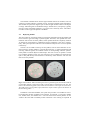
for robot navigation employing infrared communication devices called pebbles. The
robot receives topology information from these devices and moves to locations by
tracing infrared signals. We extend previously demonstrated implementation [6], and
discuss usage scenario and deployment assistance. We also conduct a user study to
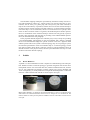
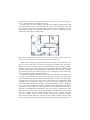
see if non-expert users can understand device usage. Fig. 1 illustrates the basic concept of the proposed method. The user only has to place pebbles at desired locations,