1
cGPSmapper Manual
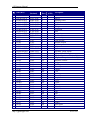
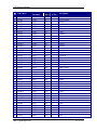
Code (Hex)
Y
Y
Y
Y
Y
Y
Y
Y
Y
Y
Y
Y
Y
Y
Y
Y
Y
Y
Y
Y
Y
Y
Y
Y
Y
Y
Y
Y
Y
Y
Y
Y
Y
Y
Y
Y
Y
Y
Y
Y
Y
Y
0x0209
0x020a
0x020b
0x020c
0x020d
0x020e
0x020f
0x0210
0x0211
0x0212
0x0213
0x0214
0x0215
0x0216
0x0217
0x0218
0x0300
0x0301
0x0302
0x0303
0x0304
0x0305
0x0306
0x0307
0x0308
0x0309
0x030a
0x030b
0x0400
0x0401
0x0402
0x0403
0x0404
0x0405
0x0406
0x0407
0x0408
0x0409
0x040a
0x040b
0x040c
0x040d
http://cgpsmapper.com/
Code
(Decimal)
521
522
523
524
525
526
527
528
529
530
531
532
533
534
535
536
768
769
770
771
772
773
774
775
776
777
778
779
1024
1025
1026
1027
1028
1029
1030
1031
1032
1033
1034
1035
1036
1037
Filter
(Dec.)
2
2
2
2
2
2
2
2
2
2
2
2
2
2
2
2
3
3
3
3
3
3
3
3
3
3
3
3
4
4
4
4
4
4
4
4
4
4
4
4
4
4
Find
(GPS)
N
N
N
N
N
N
N
N
N
N
N
N
N
N
N
N
N
N
N
N
N
N
N
N
N
N
N
N
Y
Y
Y
Y
Y
Y
Y
Y
Y
Y
Y
Y
Y
Y
Description
Port hand buoy
Starboard hand buoy
Special purpose buoy
Safe water buoy
Platform buoy
Beacon with north topmark
Beacon with south north topmark
Beacon with east topmark
Beacon with west topmark
Isolated danger beacon
Port hand beacon
Starboard hand beacon
Special purpose beacon
Mooring buoy
Fixed point
Pole
Depth point
Depth point invisible
Depth point underscore
Spot height
Building
Chimney
Church
Tanks
Tower
Rock
Triangulation point
Radio mast
Isolated danger
Obstruction
Wreck
Exposed wreck
Well
Foul
Explosive
Fish haven
Obstruction that covers
Marine farm
Dangerous rock
No bottom found
Exposed rock
Dangerous rock
116 of 130