1
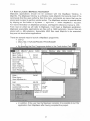
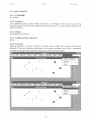
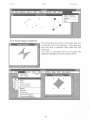
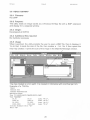
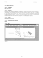
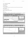
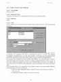
MAPBASIC UTILITIES
Michel Larue
SOPAC Secretariat
September 1995
SOPAC Miscellaneous Report 206
This project was partly supported with funds provided by the
Government of France
TABLE OF CONTENTS
1. INTRODUCTION
1
1.1 What is MapInfo?
1
1.2 What is MapBasic?
1
1.3 Origin of the utilities
1
1.4 How to launch a MapBasic programme?
2
1.5 General use of the applications
3
1.6 Other ways
5
1.7 STOP a MAPBASIC PROGRAM
6
1.8 Cosmetic layer
6
1.9 Additional files required
6
1.10 Distribution files
6
2. LIST OF THE UTILITIES
7
2.1 SOPAC Utilities
7
2.2 KGM Utilities
7
2.3 MAPINFO
8
3. USER MANUAL
9
3.1 UTILITY
3.1.1 FileName
3.1.2 Use
3.1.3 Possible developments
9
9
9
10
3.2 OPEN TABLE
3.2.1 FileName
11
11
3.3 GRID5
3.3.1 Filename
3.3.2 Purpose:
3.3.3 Origin:
3.3.4 Additional files required
13
13
13
13
13
3.4 JOINT POINTS
3.4.1 FILENAME
3.4.2 Purpose:
3.4.3 Origin:
3.4.4 Additional files required
3.4.5 Example:
17
17
17
17
17
17
B.M. Larue
28-Sep-95
3.4.6 Known bugs, limitations
MA_BAS1 DOC
18
3.5 MAKE POINTS
3.5.1 FILENAME
3.5.2 Purpose:
3.5.3 Origin:
3.5.4 Additional required files:
3.5.5 Known Bugs, Limitations:
19
19
19
19
19
19
3.6 READ A BITMAP
3.6.1 Filename
3.6.2 Purpose:
3.6.3 Origin:
3.6.4 Additional files required
3.6.5 Usage
3.6.6 Known bugs, limitations
20
20
20
20
20
20
21
3.7 RESIZE
3.7.1 File Name
3.7.2 Purpose:
3.7.3 Origin:
3.7.4 Additional files required
3.7.5 Use
3.7.6 Known bugs, limitations
22
22
22
22
22
22
23
3.8 TEST SYMBOLS
3.8.1 Filename
3.8.2 Purpose:
3.8.3 Origin:
3.8.4 Additional files required
3.8.5 Use
3.8.6 Known bugs, limitations
24
24
24
24
24
24
24
3.9 Vector components
3.9.1 Filename
3.9.2 Purpose:
3.9.3 Origin:
3.9.4 Additional files required
3.9.5 Use
3.9.6 Known bugs, limitations
25
25
25
25
25
25
25
3.10 Add Arrows to Vectors
3.10.1 Filename
3.10.2 Purpose:
3.10.3 Origin:
3.10.4 Additional files required
3.10.5 Use
3.10.6 Known bugs, limitations
26
26
26
26
26
26
27
3.11 EXPORT NODES
3.11.1 Filename
3.1 1.2 Purpose:
3.11.3 Origin:
3.1 I .4 Additional files required
3.11.5 Use
3.11.6 Known bugs, limitations
3.11.7 Remarks
3.1 1.8 Possible developments
28
28
28
28
28
28
28
28
28
2
B.M.Larue
28-Sep-95
MAP_BAS1.DOC
3.12 MOVE BY A VECTOR
3.12.1 Filename
3.12.2 Purpose:
3.12.3 Origin:
3.12.4 Additional files required
3.12.5 Use
3.12.6 Known bugs, limitations
3.12.7 Remarks
3.12.8 Possible developments
29
29
29
29
29
29
29
29
29
3.13 Move One Table Between 0 and 360'
3.13.1 Filename
3.13.2 Purpose:
3.13.3 Origin:
3.13.4 Additional files required
3.13.5 Use
3.13.6 Known bugs, limitations
3.13.7 Remarks
3.13.8 Possible developments
30
30
30
30
30
30
30
30
30
3.14 MOVE SEVERAL TABLE BETWEEN 0 and 360'
3.14.1 Filename
3.14.2 Purpose:
3.14.3 Origin:
3.14.4 Additional files required
3.14.5 Use
3.14.6 Known bugs, limitations
3.14.7 Remarks
3.14.8 Possible developments
31
31
31
31
31
31
31
31
31
3.15 Break Region :
3.15.1 Filename
3.15.2 Purpose:
3.15.3 Origin:
3.15.4 Additional files required
3.15.5 Use
3.15.6 Known bugs, limitations
3.15.7 Remarks
3.15.8 Possible developments
32
32
32
32
32
32
33
33
33
3.16 CLEAN POLYGONS
3.16.1 Filename
3.16.2 Purpose:
3.16.3 Origin:
3.16.4 Additional files required
34
34
34
34
34
34
35
35
35
36
36
36
36
36
36
3.16.5 Use
3.16.6 Known bugs, limitations
3.16.7 Remarks
3.16.8 Possible developments
3.16.9 Filename
3.16.10Purpose:
3.16.11 Origin:
3.16.12 Additional files required
3.16.13 Use
3.16.14 Known bugs, limitations
37
31
3.17 IMPORT MULTIPLE MIF
3.17.1 Filename
3
B.M.Larue
28-Sep-95
3.17.2 Purpose:
3.17.3 Origin:
3.17.4 Additional files required
3.17.5 Use
MAP-BAS1 DOC
37
37
37
37
37
37
37
3.17.6 Known bugs, limitations
3.17.7 Remarks
3.17.8 Possible developments
3.18 FIXED LENGTH ASCII IMPORT
3.1 8. 1 FILE NAME:
3.1 8.2 DESCRIPTION:
3.18.3 ORIGIN
3.18.4 USE
38
38
38
38
38
3.1 9 INTERSECTION OF 2 REGIONS
39
39
39
39
39
3.19.1 FILENAME
3.19.2 DESCRIPTION
3.19.3 ORIGIN:
3.19.4 USE
3.20 DRAW LINES TO POINT
3.20.1 FILENAME
3.20.2 DESCRIPTION
3.20.3 ORIGIN:
3.20.4 USE
41
41
3.21 CONNECT POINTS
3.21.1 FILENAME
3.21.2 DESCRIPTION:
3.21.3 ORIGIN:
3.21.4 USE:
43
43
43
43
43
3.22 Overlay tables
3.22.1 FILE NAME:
3.22.2 DESCRIPTION:
3.22.3 ORIGIN
3.22.4 USE:
3.22.5 Bugs, Limitations
44
44
44
44
44
44
41
41
41
4
B.M.Larue
28-Sep-98
MAP_BAS1.DOC
1. INTRODUCTION
1.1 WHAT IS MAPINFO?
MapInfo is the mapping and medium range GIS’ software that SOPAC recommends
for its member countries. It offers an acceptable compromise between power and
user friendliness. As part of a European Union funded project, it has been distributed
to ACP member countries. It has been as well adopted by other projects and is
becoming a de facto standard in the Pacific region.
One of the reasons it has been adopted is its relative simplicity and the short learning
curve associated. The simplicity is at the cost of its power. The successive updates
address progressively the limitations, but due to its philosophy, it remains and will
remain limited. Some limitations are acceptable, other have to be overcome.
Mapbasic offers solutions.
1.2 WHAT IS MAPBASIC?
Mapbasic is a companion product of MapInfo that allows to develop either full standalone applications such as EasyMap developed by ERSIS for FFA, or small utilities.
It is a development language similar to a Basic language with functionalities to
address geographical features.
1.3 ORIGIN OF THE UTILITIES
MapInfo comes off the shelf with some utilities, such as a grid or a scale makers.
MapBasic comes also with some more utilities. Along the time, some developers at
MapInfo, Kevin Mahonet in particular, wrote utilities to ease their work. Most of those
are accessible on INTERNET. Unfortunately, the South Pacific is not yet properly
connected to the outside world, as well as interconnected regionally. In addition, they
are often designed for a specific use. Some has also been developed at SOPAC.
They have been designed primarily by programmers for programmers. Therefore
they needed some cleaning before being distributed to end-users.
The present set of utilities has been carefully checked and partially rewritten to be
distributed. A user manual is also provided which gives a brief description of what
they do, how they work and what they produce. Nevertheless some utilities are
sufficiently self explanatory so they do not need to be documented.
The present report makes a summary of what is actually available. It can also be
used as a guide of the capabilities of MapInfo/Mapbasic. Therefore, a user in country
can seek support to have some extension developed.
As a result it will contribute to a better use of the tool installed.
These utilities are full standalone programmes but each of them performs one single
function. They also give indications of ways and mean of programming with
MapBasic.
Geographical Information system
2 ACP, Africa, Carribean, and Pacific, countries which signed the Lome covention and can receive
funds from European Union
1
B.M.Larue
28-Sep-95
MAP_BAS1.
DOC
2. LIST OF THE UTILITIES
As already pointed out, the utilities are coming from three main sources: SOPAC,
MapInfo as standard distribution and Kevin Mahoney (referenced as KGM) utilities.
2.1
SOPAC UTILITIES
. COORDINATES
. GRID5
. JOINT POINTS
. MAKEPOINTS
. READBITMAP
. RESIZE WINDOW
. PRINT ACTIVE SYMBOLS
. VECTOR COMPONENTS
. ADD ARROWS TO VECTOR
. EXPORT NODES
. BREAK REGIONS
. IMPORT MULTIPLE MIF
. IDENTICAL WINDOWS
. OPEN TABLE (FULL PATH)
2.2 KGM UTILITIES
.
.
.
.
.
.
.
.
.
.
.
.
.
.
.
.
.
.
.
.
.
.
.
.
.
.
.
AGGREGATE LINES
AGGREGATE SYMBOLS
ASCII EXPORT
BUFFER SELECTION
CLONE WINDOW
CLOSE TABLE(S)
COMBINE LAYERS
CONNECT POINTS
CUT STREETINFO FILES
CUT STREETS IN REGION
DDMMSS TO DECIMAL DEGREES
DISTANCE TO OBJECTS
DRAW LINES TO POINT
FIND STREET INTERSECTION
FIXED LENGTH ASCII IMPORT
INTERSECTION OF 2 REGIONS
LABEL STREETS AUTOMATICALLY
LINEWITHIN
MAKE SCREEN GRID
OPEN MULTIPLE FILES
OPTIMISE LOCATION
OPTIMISE TABLE STRUCTURE
POINT DISPERSION
PROJECTIONS, ETC.
RANDOM NUMBER GENERATOR
REGION WITHIN
RESIZE MAPPER FOR LAYOUT
7
B M Larue
28-Sep-95
.
.
.
.
.
.
.
SELECT ALL IN SCREEN
SHADELAYER
SORTTABLE
STREET ALIASES
STREET NAMES WITHIN
UPDATE COLUMN VALUES
UTILITY (Launch a utility with Full path)
2.3 MAPINFO
. AUTOCAD LINK
. ADD NODES
. GEOCODE
. GEOSCAN
. MAKE SHIELD
. SYMBOL EDITOR
. INFO TABLE
. DDEEXAMPLE
. SCALEBAR
. OVERVIEW
. TEXTBOX
8
MAP-BAS1DOC
B M Larue
28-Sap-95
MAP_BAS1.DOC
3. USER MANUAL
3.1 UTILITY
3.1.1 File Name
UTILITY. MBX
3.1.2 Use
Before we start, there is a useful utility called "UTILITY" that can be used to help
handling of the utilities. One of the difficulties in Windows is to find where a particular
file is in the sub-directory tree. Windows does remember one particular location and
whenever an open file is performed, the dialogue will be issued from this particular
location. It would be very handy to be able to store the full path to a particular file, in
this case a utility. This program uses one capability of MapInfo that is: it is a data
base. Usually it is used for its geographical data, but it can handle tabular data as
well.
This utility makes use of a table with the following structure:
Field Field Name Type
Width
1 UTIL_NAME
Character
25
2 FILE NAME
Character
12
Character
60
3 FILE-PATH
4 MAPBASIC
Logical
1
5 DESC1
Character
60
Character
60
6 DESC2
Character
60
7 DESC3
8 FILES_NEED Character
60
9 ORIGIN
Character
10
10 USE
Memo
10
11 BUGS_LIMIT Memo
10
12 NEXT
Memo
10
When launched, the utility adds a menu in the file system and opens this database in
a hidden state. Therefore the user cannot browse or edit it. To do so it is necessary
to open the table separately.
9
B.M.Larue
28-Sep-95
MAP_BAS1.DOC
3.6.6 Known bugs, limitations
It replaces an existing file with the same name without prompting. It opens the image
as IMAGE Table, if an image of the same name exists, there could be a conflict.
21
B.M. Larue
28-Sep-95
MAP-BAS1DOC
3.11 EXPORT NODES
3.11.1 Filename
EXP_PNTS.MB
3.1 1.2 Purpose:
It exports the coordinates of the nodes of Polygons, Polylines and points to a Text
file. It also exports a third dimension taken from one column of the table.
3.11.3 Origin:
Developed at SOPAC
3.1 1.4 Additional files required
None
3.11.5 Use
The utility prompts the user to choose successively a TXT file to export to, a table to
export from and a column of this table to be used as the third coordinate (Z).
3.11.6 Known bugs, limitations
3.1 1.7 Remarks
This utility is to be compared with EX_ASC from KGM.
3.1 1.8 Possible developments
28
B.M.Larue
28-Sep-95
MAP_BAS1.DOC
3.13 MOVE O N E TABLE BETWEEN 0 AND 360'
3.13.1 Filename
MV_WEST3
3.13.2 Purpose:
The utility moves all the objects contained in a table to fit in the 0-360" window.
3.13.3 Origin:
Developed at SOPAC
3.13.4 Additional files required
None
3.13.5 Use
The utility prompts the user to choose a table to move.
3.13.6 Known bugs, limitations
3.13.7 Remarks
3.13.8 Possible developments
30
B.M.Larue
28-Sep-95
MAP-BAS1DOC
3.14 MOVE SEVERAL TABLE BETWEEN 0 AND 360'
3.14.1 Filename
MV_WEST4. MB
3.14.2 Purpose:
Moves several tables listed in a Text file to be moved to fit between 0 and 360".
3.14.3 Origin:
Developed at SOPAC
3.14.4 Additional files required
None
3.14.5 Use
The utility prompts the user to provide a text file with the names of the files, including
their complete path.
C:/TMP/TEMP
The extension TAB can be omitted.
All the tables will be closed and the utility opens the tables one by one. It gives a
control on which table is being moved in the message window.
3.14.6 Known bugs, limitations
All the objects to be moved should not cross the 0" limit. They should then be cut
before the work is done. This can be done by using the Menu>Object>Set Target
then Menu>Object>Split command.
The tables are automatically packed before starting the work.
3.14.7 Remarks
3.14.8 Possible developments
31
B.M.Larue
MAP_BAS1.DOC
28-Sep-95
3.16.6 Known bugs, limitations
It works actually only on two polygons.
3.16.7 Remarks
3.16.8 Possible developments
Extension to an unlimited number of polygons.
35
B.M.Larue
28-Sep-95
MAP_BAS1.DOC
3.17 IMPORT MULTIPLE MIF
3.17.1 Filename
IMPORT1.MB
3.17.2 Purpose:
It allows to generate a text file with the names of the MIF files to import, then it
imports successively all the MIF files and saves them as MapInfo standard format.
3.17.3 Origin:
Developed at SOPAC
3.17.4 Additional files required
A text file that contains the name and location of the MIF Files to import.
3.17.5 Use
When launched, this utility opens a DOS window. This is to let the user select the
files to be imported.
1. GO I N T O THE PROPER DIRECTORY
2 . TYPE 'DIR *.MIF /B > MYFILE.TXT
3.
T Y P E E X I T TO RETURN TO MAP INFO
Then the utility prompts the user to open the file, select the one just created.
3.17.6 Known bugs, limitations
The progress bar requires to have MapInfo in the forefront.
3.17.7 Remarks
Instead of the command DIR *.MIF /B, any other command can be used to generate
the text file. For instance in the case where the all files are not in one single directory
(DIR/S/B). In any case, it is possible to edit the file before opening it in MapInfo, to
add or remove some of the files not to be imported. The DOS part of the utility is just
an example of one way to create a file list.
3.17.8 Possible developments
37
B.M.Larue
3.21
28-Sep-95
MAP_BAS1.DOC
CONNECT POINTS
3.21.1 FILE NAME:
conndots.mbx
3.21.2 DESCRIPTION:
This App will connect points from a tableusing either objects or lat/long columns.
3.21.3 ORIGIN:
KGM
3.21.4 USE:
It does about the same thing as Joint_pnts. The main difference is that instead of
working on a selection, it works on entire table. Also it has two options, either it
joints the points defines as objects, or tit makes a line based on latitudes and
longitudes of the points even if they are not on the map as object. The table must be
mappable to work.
43
B.M.Larue
MAP_BAS1.DOC
28-Sep-95
If you find out which statement (maybe the overlap function?) is causing this let m e
know will you ? Another problem you might stumble on is that the tables you a r e
overlaying may not contain deleted records, pack them first!
45