1
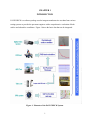
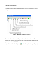
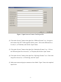
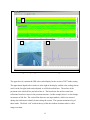
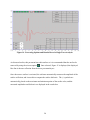
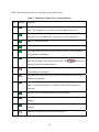
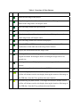
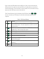
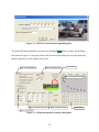
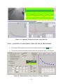
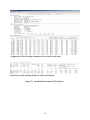
1. Report No.
2. Government Accession No.
3. Recipient's Catalog No.
FHWA/TX-08/5-4495-01-P1
4. Title and Subtitle
5. Report Date
PAVECHECK: UPDATED USER’S MANUAL
January 2008
6. Performing Organization Code
7. Author(s)
8. Performing Organization Report No.
Wenting Liu and Tom Scullion
Product 5-4495-01-P1
9. Performing Organization Name and Address
10. Work Unit No. (TRAIS)
Texas Transportation Institute
The Texas A&M University System
College Station, Texas 77843-3135
11. Contract or Grant No.
12. Sponsoring Agency Name and Address
13. Type of Report and Period Covered
Texas Department of Transportation
Research and Technology Implementation Office
P. O. Box 5080
Austin, Texas 78763-5080
Product :
September 2006-November 2007
Project No. 5-4495-01
14. Sponsoring Agency Code
15. Supplementary Notes
Project performed in cooperation with the Texas Department of Transportation and the Federal Highway
Administration.
Project Title: Implementation of an Integrated Deflection and Ground Penetrating Radar Data Analysis
System
URL: http://tti.tamu.edu/documents/5-4495-01-P1.pdf
16. Abstract
The PAVECHECK data integration and analysis system was developed to merge Falling Weight
Deflectometer (FWD) and Ground Penetrating Radar (GPR) data together with digital video images of
surface conditions. In project 4495, the earlier system has continued to be expanded with new capabilities.
This report provides an updated user’s manual for the new program. It is accompanied by a CD that contains
an executable program to load the software, along with two test data sets. One data set includes a folder
called US77 which contains files of GPR and video images. These data is the typical raw data collected in
the field. These files are used to demonstrate how data can be loaded and viewed within PAVECHECK. A
second data set named ANNEX is also loaded. This complete data set includes FWD and photos of
pavement cores. This data set is used to demonstrate the full capabilities of PAVECHECK.
This system has tremendous potential to assist Texas Department of Transportation (TxDOT) engineers
with future forensic and pavement rehabilitation studies. The PAVECHECK framework can also assist in
future pavement layer data base efforts and in documenting and evaluating the performance of research test
sections.
17. Key Words
18. Distribution Statement
Ground Penetrating Radar, GPR, Falling Weight
Deflectometer, FWD, Pavements, Backcalculation
No restrictions. This document is available to the
public through NTIS:
National Technical Information Service
Springfield, Virginia 22161
http://www.ntis.gov
19. Security Classif.(of this report)
20. Security Classif.(of this page)
21. No. of Pages
Unclassified
Unclassified
50
Form DOT F 1700.7 (8-72)
22. Price
Reproduction of completed page authorize
PAVECHECK: UPDATED USER’S MANUAL
by
Wenting Liu, P.E.
Associate Research Engineer
Texas Transportation Institute
and
Tom Scullion, P.E.
Research Engineer
Texas Transportation Institute
Report 5-4495-01-P1
Project 5-4495-01
Project Title: Implementation of an Integrated Deflection and Ground Penetrating
Radar Data Analysis System
Performed in cooperation with the
Texas Department of Transportation
and the
Federal Highway Administration
January 2008
TEXAS TRANSPORTATION INSTITUTE
The Texas A&M University System
College Station, Texas 77843-3135
DISCLAIMER
The contents of this report reflect the views of the authors, who are responsible for the
facts and the accuracy of the data presented herein. The contents do not necessarily reflect the
official views or policies of the Texas Department of Transportation or the Federal Highway
Administration. The United States Government and the State of Texas do not endorse products
or manufacturers. Trade or manufacturers’ names appear herein solely because they are
considered essential to the object of this report. This report does not constitute a standard,
specification, or regulation. The engineer in charge was Tom Scullion, P.E. (Texas, # 62683).
v
ACKNOWLEDGMENTS
This project was made possible by the Texas Department of Transportation and the
Federal Highway Administration. Elias Rmeili, P.E. from the Brownwood District served as
project director and his support for the implementation of PAVECHECK is greatly appreciated.
vi
TABLE OF CONTENTS
Page
List of Figures .............................................................................................................................. viii
List of Tables ................................................................................................................................. ix
Chapter 1. Introduction ...................................................................................................................1
Chapter 2. Hardware Requirements for PAVECHECK .................................................................5
Chapter 3. Loading PAVECHECK and Creating a Project File.....................................................7
GPR Data Collection............................................................................................................7
Loading the Software...........................................................................................................7
Creating a Project File .........................................................................................................8
Chapter 4. User’s Guide for PAVECHECK Using Supplied Data...............................................13
Description of the GPR Color Display ..............................................................................15
Processing a Single GPR Trace .........................................................................................19
Automatic Peaks Tracking.................................................................................................23
Using the Digital Video Module........................................................................................25
Processing FWD Data in PAVECHECK...........................................................................27
MODULUS Backcalculation Module................................................................................29
Select Station (Top Left)....................................................................................................31
MODULI Ranges...............................................................................................................32
Control Buttons (Running Backcalculation)......................................................................32
Chapeter 5. Backcalulation Case Study Using the ANNEX.PRJ Data.........................................35
Step 1. Load Data and Compute Layer Thicknesses for Entire Data Set .........................35
Step 2. Computing Layer Moduli Using One Set of Thicknesses ....................................36
Step 3. Complete Analysis Using Different Thickness for Each FWD Location.............37
Reference .......................................................................................................................................39
vii
LIST OF FIGURES
Figure
Page
1.
Elements of the PAVECHECK System...............................................................................1
2.
Example of a Detailed PAVECHECK Display ...................................................................2
3.
Main Menu Screen in PAVECHECK..................................................................................8
4.
Input Screen to Create a New Project File...........................................................................9
5.
Completed Entries to Create a Project File for the US77 Data..........................................10
6.
Opening PAVECHECK Screen Showing US77 Data .......................................................11
7.
Initial Display of Data in the Annex.prj File .....................................................................14
8.
Combined FWD and GPR Display ....................................................................................15
9.
GPR Color Display ............................................................................................................16
10.
Significance of GPR Display .............................................................................................17
11.
Options in the GPR Display...............................................................................................18
12.
GPR Display after Removal of Surface Reflection ...........................................................18
13.
Principles of Ground Penetrating Radar ............................................................................19
14.
Processing Options and Results Boxes in Single Trace Analysis......................................20
15.
Using the Remove Surface Option in Single Trace Analysis ............................................21
16.
Results from Single Layer Analysis ..................................................................................21
17.
Using the Automated Layer Thickness Tracking Options.................................................23
18.
Typical PAVECHECK Video Image with Menu Options ................................................25
19.
Toolbar Button to Open or Close the FWD Frame............................................................27
20.
FWD Frame with Buttons..................................................................................................27
21.
Toolbar Button to Access the FWD Information Dialog Box ...........................................29
22.
FWD Device Information Input Dialog Box .....................................................................30
23.
FWD Backculation Analysis Dialog Box ..........................................................................30
24.
Computing Thickness for Entire Annex Data Set..............................................................36
25.
Backcalculation Using a Single Set of Layer Thickness ...................................................36
26.
Results from Station 1........................................................................................................37
27.
Stored Results from the FWD Analysis.............................................................................38
viii
LIST OF TABLES
Table
Page
1.
Hardware Requirements for Running PAVECHECK .........................................................5
2.
Project Information for the Annex Sample Data ...............................................................13
3.
Functions of Single Trace Analysis Buttons......................................................................22
4.
Functions of Video Buttons ...............................................................................................26
5.
FWD Control Buttons ........................................................................................................28
6.
FWD Response Display Control Buttons ..........................................................................29
7.
Thickness Selection Option Table .....................................................................................31
ix
CHAPTER 1
INTRODUCTION
PAVECHECK is a software package used to integrate nondestructive test data from various
testing systems to provide the pavement engineer with a comprehensive evaluation of both
surface and subsurface conditions. Figure 1 shows the basic data that can be integrated.
Figure 1. Elements of the PAVECHECK System.
1
PAVECHECK permits the user to:
•
Display Ground Penetrating Radar (GPR) and synchronized video images. The video
shows the existing surface condition, and the GPR identifies the subsurface condition,
which permits the user to potentially identify the possible cause of surface distress.
•
Integrate other photographs of pavement cores or other relevant data, which can be useful
in the pavement evaluation.
•
Integrate deflection data collected independently with Falling Weight Deflectometers.
•
PAVECHECK also includes the MODULUS 6 backcalculation algorithms (Scullion,
Chen and Lau, 1995). The PAVECHECK system uses the layer thickness determined
from the GPR data within the backcalculation analysis.
Figure 2 shows one example of a display from PAVECHECK.
Figure 2. Example of a Detailed PAVECHECK Display.
2
In Figure 2, the upper left quadrant shows a video image of the location where data were
collected. The upper right shows a segment of color-coded GPR data. The basics of the GPR
signal processing and the color-coding system are given elsewhere (Liu and Scullion, 2001). In
the GPR display, the depth in inches is given on the vertical axis at the right of the display, and
the distance in miles and feet is given in the horizontal (x axis). The vertical red line to the left
of the figure is where the displayed video image was taken. The bottom left quadrant has the
FWD bowls and the results from the backcalculation analysis. For this deflection analysis, the
point specific layer thicknesses were used. The quadrant at the bottom right has the GPR trace
for the test location. The computed layer thicknesses at this location are displayed; these
thicknesses that were used in the FWD analysis.
This User’s Manual is intended to demonstrate how to load data into PAVECHECK and how to
use the many functions available within the system. The PAVECHECK software is provided on
a CD that accompanies this report. The PAVECHECK executable module will load the program
and two folders containing test data into the default C:\PAVECHECK\ directory. The US77
folder is intended to represent a typical new data set that will need to be input into
PAVECHECK. These data are used to demonstrate how to create a project file and view data.
The ANNEX folder contains an already existing comprehensive project file that includes FWD
data.
3
CHAPTER 2
HARDWARE REQUIREMENTS FOR PAVECHECK
Table 1 shows the minimum hardware requirements required for the system.
Table 1. Hardware Requirements for Running PAVECHECK.
No.
Requirements
Basic Requirement
Recommended Value
1
Operation System
Windows 98
Windows XP
2
System Memory (RAM)
At least 1.0 gigabyte
2.0 gigabytes or
higher
3
Monitor Resolution
At least 1024×768
1280×1024 or higher
4
Free Hard Drive Space
At least 5 gigabytes
20 gigabytes
System memory less than 1.0 gigabyte may result in frequent system crashes. The system has
also been reported to run well on the new Microsoft Vista operating system but this operating
system has not been fully evaluated.
5
CHAPTER 3
LOADING PAVECHECK AND CREATING A PROJECT FILE
In this section, the steps required to load the system and create a project (or work) file will be
explained. For this example, the data sets provided in the US77 folder will be input into
PAVECHECK.
GPR DATA COLLECTION
GPR and synchronized video images are collected using the MRADAR data acquisition system,
details of which are given elsewhere (Liu and Scullion 2007). The minimum data required for
the system are three files, as provided in the US77 folder:
•
the GPR data collected over the test section (US77nbol.dat),
•
the metal plate GPR file collected after data collection (US77mtp.dat), and
•
the zipped image file provided by the GPR data collection operator (US77nbol.img).
LOADING THE SOFTWARE
PAVECHECK is provided on a CD that contains a PAVECHECK_setup.exe file. To install
PAVECHECK, double click the “PAVECHECK_Setup” icon
and follow the
instructions. After hitting the “Start” button, if the program asks for permission to overwrite
existing DDL files, click “NO”. The two work folders, US77 and ANNEX, will automatically
be loaded into the C:\PAVECHECK directory. The US77 directory contains the three data files
described above.
After installation, the PAVECHECK icon
will be loaded onto the computer desktop.
7
CREATING A PROJECT FILE
Click on the PAVECHECK icon on the desktop, and the main menu screen shown in Figure 3
will appear.
Figure 3. Main Menu Screen in PAVECHECK.
The function of each of the menus in Figure 3 will be described later in this report. The
following steps will create a project file (*.prj). This example demonstrates the minimum data
input requirement for PAVECHECK.
(1) Click on the Open New Project icon
and the following box will appear (Figure 4).
8
Figure 4. Input Screen to Create a New Project File.
(2) Click on the “Browse” button to the right of the “GPR test file name” row. Navigate to
the location of the US77 folder supplied with the system. Click on the GPR data file to
be used (i.e., us77nbol.dat), and click the “Open” button.
(3) Click on the “Browse” button to the right of the “Metal plate file name” row. Click on
the GPR metal plate file to be used (i.e., us77mtp.dat) and click the “Open” button.
(4) Click on the “Browse” button to the right of the “Zip Image file name” row. Click on the
image file to be used (i.e., us77nbol.img), and click “Open”
(5) Add a project name and project comments or leave blank. Figure 5 shows the completed
input screen.
9
Figure 5. Completed Entries to Create a Project File for the US77 Data.
(6) Click the “OK” button. The created US77NB.prj file will be created and stored in the
C:\PAVECHECK directory. (Note: in the future to open up these GPR data and photos,
the “Open Existing *.prj file” icon
can be used.)
(7) To display the GPR data and associated video images, click on the “Display the project”
icon
. The display shown in Figure 6 will appear.
10
A
B
C
Figure 6. Opening PAVECHECK Screen Showing US77 Data.
The upper box (A) contains the GPR color-coded display for the section of US77 under testing.
The approximate depth scale in inches is at the right of the display, and the color-coding scheme
used is at the far right; both can be adjusted, as will be described later. The surface of the
pavement is the solid red line just below Box A. The lines below the surface come from
reflections from lower layers in the pavement structure. In this example, there is a clear change
in structure at 200 feet. The vertical blue lines are user input markers, which were entered
during data collection to identify features along the section. The operator maintains a log of
these marks. The black “tick” marks at the top of this box indicate locations where a video
image was taken.
11
Box B is the video image collected at 0 miles and 39 feet into the section. If the operator clicks
(left mouse button) on any location in Box A, the corresponding video image will be displayed in
Box B.
Box C is the GPR trace collected at one location, initially set to the first location in the run. If
the operator clicks (left mouse button) on any location in Box A, the corresponding GPR trace
will be displayed in Box C.
The horizontal blue bar in the middle of the figure is a scroll bar; it can be moved with the
mouse. It allows the user to move rapidly through the available data. This feature is useful when
long sections of highway have been tested.
Use the following steps to quickly review the data stored in this data set:
1) Click anywhere in the color-coded GPR data. A vertical red line will appear, and the
video image and GPR trace from that location will be displayed.
2) Click anywhere in the video box, and a set of drop-down menus will appear.
3) As a short cut, hit the X key on the keyboard and the images will scroll forward. In this
process, the images and GPR data are synchronized. Hit the X key again to stop the
scrolling.
4) Use the Z key to move backward.
The function of each of the drop-down menus and options available within PAVECHECK will
be discussed in the remainder of this report.
Note: PAVECHECK requires substantial free memory to display video images; 2 MB is
recommended. Computer systems with small amounts of RAM or with large numbers of
resident programs may have problems. In this case, the system will give an error message and
shut down.
12
CHAPTER 4
USER’S GUIDE FOR PAVECHECK USING SUPPLIED DATA
The PAVECHECK set-up disk automatically loads a complete data set from the Texas
Transportation Institute (TTI’s) Riverside campus into the ANNEX folder. For this data set, the
project file (annex.prj) has already been created and contains the files shown in Table 2. This
data set contains FWD data and photographs of the test section. The worked examples discussed
in the reminder of this report will use these data to demonstrate the various features of
PAVECHECK.
Table 2. Project Information for the Annex Sample Data.
Items
Value
Comments
Project file name
Annex.prj
prj is the default extension name
Project comment
Annex test site about
Must be less than 120 characters
1800 ft long
Project folder
C:\PAVECHECK\Annex Give the location of your project file
Radar folder
Subfolder, if left blank, it means these test data are
Image folder
kept in the project folder
FWD folder
GPS folder
Core folder
Core
Core information kept in subfolder “core”
Radar file
Annex_GPR.dat
GPR file name
Metal file
Mtp.dat
Metal plate GPR file
Image file
ZIP.img
Zipped video file
FWD file
Annex.FWD
FWD field test file with Dynatest R80 format
GPS file
GPS.lst
Core file
Core.lst
To run PAVECHECK, click on the icon
. The menu bar shown previously in Figure 3
appears. This time, click on the “Open Existing *.prj file”
and navigate to the ANNEX
folder in the PAVECHECK directory. To select the data set, click on “Annex.prj”; then to
display the data, click the
button. Figure 7 will appear.
13
Figure 7. Initial Display of Data in the Annex.prj File.
Click the
button on the main toolbar. This button will load the FWD data specified
in the project file into the bottom left box. Click on the FWD screen (lower left quadrant) with
the left mouse button, and Figure 8 will appear showing the pull-down menu items for FWD
analysis. During FWD data collection, four drops at different heights were made at each test
location. The four different colored lines are the deflection bowls for the first test location.
Details of this screen will be described later.
14
Figure 8. Combined FWD and GPR Display.
Re-click the
button, and the FWD data will be removed. The functions available in each of
the display boxes will now be described in detail.
DESCRIPTION OF THE GPR COLOR DISPLAY
Details of the GPR display screen are described below in Figure 9.
•
The top of the color display shows the location of each data item
o Red marks indicate that a photo was taken at this location. (Click on the red
mark, and the photo will be displayed.)
o Black marks indicate the location where a digital image was taken.
o Blue marks are where the FWD drop was made.
15
Red indicates a photo location
High Limit Color Scale Slide
Top black mark shows image location
blue marks shows location of FWD data
Current Single Trace Location
Top layer Dielectric Curve
Low Limit Color Scale Slide
DMI (mile+feet)
Color Scale
Dielectric Curve Scale
Depth Scale (inches)
Figure 9. GPR Color Display.
•
The plot at the bottom of the display shows the dielectric value of first layer, which is
useful in checking the uniformity of surface layer density. Periodic decreases signify
compaction problems. The scale at the left of this plot shows the numeric values of
dielectric.
•
The numbers at the bottom of the plot are from the distance measuring instrument
(DMI) in the GPR van; they give the distance in miles and feet. The current DMI
systems are calibrated at TTI’s Riverside campus to be accurate to within 1 foot in 1
mile. This calibration process is part of the MRADAR data acquisition program. The
calibration factors are stored within MRADAR.
•
Click anywhere in the color display with the left mouse button and a red vertical line
will appear. The video image, FWD drop, and GPR trace from that location will also be
displayed in the other boxes of Figure 8.
•
The color scale on the far right of the color display can be changed. Place the mouse on
either the red or blue arrow; hold the mouse button down; then move the arrow to a new
16
location. To redraw the display with the new settings, click the R button on the main
menu bar. The buttons govern the creation of the color display from the raw signal.
This process is useful for highlighting small reflections from lower layers.
•
The depth scale to the right of the color display can also be adjusted. Click on it with
the left mouse button; hold the mouse down, and drag it to a new location
Figure 10 shows the significance of the pavement data. To generate this plot, both the color
display bars and thickness scale bars have been adjusted. This adjustment is achieved by using
the left mouse button and dragging the feature to the new location. The surface of the pavement
is the center of the strong red reflection. The zero (0 inch) position of the depth scale is set at
this position. The pavement section has a thin HMA layer nominally 2 inches thick and a thick
granular base nominally 12 inches thick. The thickness scale on the left is for estimation
purposes only; better thickness estimates for each layer will be described later.
Surface reflection
Bottom of top layer
Thickness scale (inches)
Bottom of the base
Figure 10. Significance of GPR Display.
17
The upper left of corner of Figure 7 has the display shown in Figure 11. This display has several
features that are useful. Clicking the upper box will put the surface of the pavement (solid red
line) at the very top of the display box. The lower box (with the scissors) performs the surface
removal technique. This feature is very useful, especially with thin surfaces. After selecting this
option, Figure 12 is displayed. The H option displays the header information for this file.
Figure 11. Options in the GPR Display.
Bottom of HMA
Bottom base
Figure 12. GPR Display after Removal of Surface Reflection.
The surface removal technique is highly recommended whenever thin surfaces are encountered,
which is very frequent in Texas. As shown in Figure 12, once it is selected, the surface of the
pavement is now set at the top of the plot, and the reflection from the top of the base is more
clearly visible in the display.
18
PROCESSING A SINGLE GPR TRACE
The most accurate estimates of layer thickness are obtained from the individual GPR reflections.
Processing these reflections within PAVECHECK will be described in this section. Figure 13
shows the basics of GPR layer reflections. The reflections from the surface and pavement
interfaces are displayed as a plot of reflected energy (volts) against arrival time.
Figure 13. Principles of Ground Penetrating Radar.
The reflections of interest are the surface echo and the reflections that occur to the right of the
surface echo. By measuring the amplitude of these reflections and the time delay between them,
it is possible to compute both the layer dielectrics and layer thicknesses. Complete details of the
of this calculation process are given elsewhere (Scullion, Chen and Lau, 1995).
Click on the GPR trace box with the left mouse button and Figure 14 will appear. This figure
shows the drop-down menus from processing the individual GPR traces.
19
Figure 14. Processing Options and Results Boxes in Single Trace Analysis.
As discussed earlier, this pavement has a thin surface so it is recommended that the surface be
removed by using the scissors option
. Once selected, Figure 15 is displayed; the displayed
blue line is the true reflection from the lower pavement layers.
Once the remove surface is activated, the software automatically measures the amplitude of the
surface reflection, and it uses this to compute the surface dielectric. The (+) symbols are
automatically placed on the maximum and minimum points of the surface echo, and the
measured amplitudes and dielectric are displayed in the results box.
20
Figure 15. Using the Remove Surface Option in Single Trace Analysis.
To compute dielectrics and thicknesses for the lower layers, the user must first identify the
reflections and use the mouse to place marks (+) on the max and min values. With the surface
removal option activated, the user must identify these peaks on the blue trace. Peak
identification is done by clicking on the maximum value then by convention the trailing negative
peak. Figure 16 shows the results of this operation are shown in Figure 16 below. The results
box is automatically updated. For this particular example for trace 103, the computed
thicknesses were 2.5 inches for the surface and 11.9 inches for the base. In PAVECHECK, a
maximum of three layer thickness can be calculated.
Figure 16. Results from Single Layer Analysis.
21
Table 3 provides the function of each of the options in this screen.
Table 3. Functions of Single Trace Analysis Buttons.
No.
1
Button
Function
This button will subtract the surface reflection based on the metal plate
trace. This technique is very effective if thin asphalt layers exist.
2
This button will automatically perform the single trace analysis. This
function is not available on this version, but it will be added later.
3
Move to the previous trace.
4
Move to the next trace.
5
The Undo button will allow the trace analysis go back to the beginning
and restart the calculations.
6
This button will save the analysis results to the memory. If the user does
not click this button, the results are discarded. The
buttons also
save the result before further action.
7
Automatically track peaks in the backward direction and perform the
layer thickness calculations.
8
Automatically track peaks in the forward location and perform the layer
thickness calculations.
9
Goes backward to the trace that has the FWD test data. This button helps
users to locate the GPR trace at which the FWD field test data were
collected.
10
Forwards goes to the trace that has the FWD test data.
11
Move backwards to the trace that has already finished the single trace
analysis.
12
Move forward to the trace that has already finished the single trace
analysis.
13
Print out the single trace analysis results in detail.
22
AUTOMATIC PEAKS TRACKING
This option lets the user compute the thickness for a defined section. Figure 17 shows the
completed analysis. To define the start and end of the section, the curser is moved to the desired
location in the color display and the “Shift button and left mouse button” and “Shift – right
Mouse button” are used. The single trace analysis is then performed as described earlier. In the
case shown, the surface removal option is used in both the color and single layer analyses. The
automated tracking function is activated using the backward
and forward
buttons, and
Figure 17 will be seen. Moving the curser anywhere within this window will now display the
thickness for each location.
Right section limit
Left section
limit
Tracking pavement surface
Tracking bottom of HMAC
Tracking bottom of base
Figure 17. Using the Automated Layer Thickness Tracking Options.
23
Automated peak tracking does not work in all cases. For this process to work, the layer
interfaces must be clear, which is not always the case. Some of the factors that can influence the
success of the peak tracking function are listed below:
•
The age of the pavement. Newly constructed pavements are easier to track. In many old
pavements, the reflections from the top of the subgrade are not clear.
•
Multiple overlays will create many sub-interfaces, which make tracking much more
difficult.
•
Pavement deterioration, like cracks, will influence the quality of the captured GPR traces.
•
Moist conditions will change the dielectric values. Localized moisture makes the peak
tracking difficult.
•
Thin layers will make the two adjacent peaks overlap.
•
Defects or localized variation in the pavement structure will challenge the peak tracking.
•
Buried pipelines or metal objects will change the waveform of the GPR traces.
•
Sections of the GPR survey containing a bridge or sections that are close to a bridge will
“confuse” the peak tracking.
24
USING THE DIGITAL VIDEO MODULE
The integrated video is a key module within PAVECHECK. The user can move back and
forward throughout the pavement section and look at surface distresses and subsurface GPR data.
This feature is very important when the data are being used to diagnose the cause of the distress
and to identify locations where coring is required. Figure 18 shows the basic video display. The
distance information in miles and feet is shown in the lower left of the image. The options
available for viewing the data are shown at the top of the figure.
Figure 18. Typical PAVECHECK Video Image with Menu Options.
Table 4 describes the various menu options. Note the video image displayed is automatically
synchronized with the other PAVECHECK screens (color-coded GPR and the single GPR
display trace).
25
Table 4. Functions of Video Buttons.
No. Button Function
1
Show the first image of the project.
2
Play the images backward from the current location. Clicking the mouse
button in the image frame will stop the video.
3
Move the image frame to the previous one.
4
Move the image frame to the next one.
5
Play the image forward from the current location. Clicking the mouse button
in the image frame will stop the video.
6
Move the image frame to the last one in the project.
7
Show the GPR and FWD data at the current image frame location. This action
synchronizes all the other data to the image frame location.
8
Display the information about this image frame.
9
Clicking this button and holding it down makes the image resize itself to its
original resolution. Releasing the button will bring the image frame to its
normal size.
10
Clicking this button will display the nearest core image and information, if
present.
11
Show the image frame location on the map if GPS data are present.
12
Automatically play data backward. The images will advance, and the vertical
red line will advance on the color display showing the location of the image in
the GPR data. Note the X key performs the same function.
13
Automatically play data forward. The images will advance, and the vertical
red line will advance on the color display showing the location of the image in
the GPR data. Note the Z key performs the same function.
26
The following is a very frequently used option when reviewing GPR data within PAVECHECK:
•
Select a location of interest in the GPR color display using the left mouse button.
•
Activate the video menu by clicking on the video display box with the left mouse button.
•
Use the X key to scroll forward in the video. Press the X key again to stop the video.
Press X one more time, and the video will continue.
•
To reverse, use the Z key.
PROCESSING FWD DATA IN PAVECHECK
When the PAVECHECK program starts, the FWD data are not displayed. If the user wants to
view the FWD deflection bowls or to analyze the FWD test data, click the
toolbar (Figure 19). For the annex.prj data, after clicking the
button on the
button, the FWD data
identified in the project file will be displayed in the bottom left quadrant. Click on this area with
the left mouse button, and Figure 20 will appear.
Figure 19. Toolbar Button to Open or Close the FWD Frame.
Figure 20. FWD Frame with Buttons.
27
Figure 20 shows the FWD deflection bowl at DMI=0 feet. There are four lines that show the
deflection bowls of four load levels used in the FWD test. The thick blue line is the load level
used for backcalculation. This is the load level closest to 9000 lb. The raw data tables in the top
right corner of the FWD frame are also for this load level.
Table 5 lists the functions of each of the buttons in the FWD frame. Buttons
and
are
only active when there are FWD stations for which the backcalculation analysis has been
completed.
Table 5. FWD Control Buttons.
No.
1
Button
Function
Show the FWD backcalculation dialog box to do the FWD
backcalculation analysis. The main computations are made here and will
be discussed later.
2
This button permits the user to display the raw FWD deflection data in
graphical form. Table 6 describes these options.
3
Show the deflection data in tabular form.
4
Show the FWD data for the previous station.
5
Show the FWD data for the next station.
6
Show the previous FWD station that has already finished the
backcalculation analysis.
7
Show the next FWD station that has had the backcalculation analysis
performed.
8
Print the FWD analysis result.
28
No. Button
Table 6. FWD Response Display Control Buttons.
Function
1
Go back to the main FWD control buttons
2
Display the center geophones deflection response for the entire project.
3
Display the deflection graph for all seven sensors.
4
Display the center and outer geophones deflection response graph.
5
Display the outer geophones deflection response graph.
6
Display the load cell response graph for entire project.
7
Display the air, surface, and pavement temperature graphs.
MODULUS BACKCALCULATION MODULE
This module is the most complicated part in the PAVECHECK program. The purpose of this
chapter is to perform the FWD backcalculation with the thickness from the GPR trace analysis.
When the program reads the FWD data, the deflection bowls from all of the load levels are read.
There is a separate dialog box allowing the user to select the load level and other FWD
information before completing the FWD backcalculation. To access this dialog box, the user
needs to click the
button, as shown in Figure 21. Once selected, the dialog box shown in
Figure 22 appears. In this box, the user can change the sensor locations, the radius of loading
plate, and select the drop height to be processed. When the FWD data are loaded, the program
automatically selects a drop height closest to 9000 lb. If all the drop heights are the same, the last
drop is selected. Sensor location and radius are input from the FWD field file. This box will only
be changed if the user wishes to process data collected at a different load level or if the sensor
locations are changed. Under normal operations, this box will not be changed. Clicking the
“OK” button will update the information and exit this dialog box.
Figure 21. Toolbar Button to Access the FWD Information Dialog Box.
29
Figure 22. FWD Device Information Input Dialog Box.
The main FWD backcalculation is activated by clicking the
button in Figure 20, the dialog
box shown in Figure 23 will appear. Most of the left side of this dialog box is for the input data,
and the right side is for the display of the result.
How to select thickness
Select or display station
Control Button
Show the Deflection Bowl
Back-Calculation input data
Back-Calculation Result
How to select trace
Figure 23. FWD Backcalculation Analysis Dialog Box.
30
Result Table
SELECT STATION (TOP LEFT)
The buttons on the top left are used to select the thickness modes. There are six options to select,
as explained in. These options were added to provide the user flexibility in merging the GPR
thickness information with the FWD bowl information. In option 1, the user has already
processed the GPR data for one station and saved those results. Using option 1, this set of
thickness data will be used to process all the deflection bowls. To use options 2, 3, or 4, the user
must have already computed and saved thickness information for all the FWD test locations.
Using options 2, 3, or 4, the layer thickness at each FWD test location will be varied in the
backcalculation process.
Table 7. Thickness Selection Option Table.
Options Names
1
Use Current GPR Trace
2
Use Thickness from GPR
3
Only use the top AC layer
thickness from GPR
4
Use only the top two layers’
thickness from GPR
Use average thicknesses from the
GPR
5
6
User input thickness
Functions
Directly use the current single trace analysis thickness
result for each FWD bowl. However, the subgrade
thickness is obtained from the depth to bedrock
calculation from the deflection data using the supplied
AC layer thickness.
Directly use the thickness from the trace that is
closest to or within 6 feet of the FWD loading plate.
Calculate bowl specific subgrade thickness.
Directly use the top layer’s thickness from the trace
closest to or within 6 feet of the FWD loading plate.
This option is very useful if the base thickness is
difficult to find from the GPR data. Other layer
thicknesses are input by the user. The subgrade
thickness is calculated by depth to bedrock
calculation from the deflection data and AC layer’s
thickness.
Same as option 3, except use the top two layers’
thickness from GPR.
Average thickness from all traces’ analysis. If the
GPR section is not very long and the interfaces
between layers are clear, this is a simple way to get
the thickness.
User can input all the thickness just like the current
Modulus version 6.0 program. The thickness is no
longer related to the GPR trace thickness.
31
MODULI RANGES
In addition to the thickness input discussed above, there are other data items required for the
backcalculation process. These items are input in the lower left part of the backcalculation
dialog box. The analysis routine within PAVECHECK is essentially the system included in
MODULUS 6. Therefore, the process is limited to a maximum of a four-layer analysis, where
the lower layer is a semi-infinite stiff layer buried under a calculated subgrade thickness layer.
The user-required inputs to run the backcalculation analysis are as follows:
•
moduli range for each layer, including minimum and maximum moduli values;
•
Poisson’s ratio for each layer;
•
last layer, or the subgrade layer, need to input the most probable moduli value; and
•
add any additional layers, such as subbases.
For the lower layers, the user can select the material type to define the input values using the
drop-down list. The material types provide a “first-cut” set of moduli values that can be
overwritten by the user.
CONTROL BUTTONS (RUNNING BACKCALCULATION)
There are two ways to run the FWD backcalculation; one is a single bowl FWD backcalculation
with the first button “Back Calculation”; another is running all stations with the button “Run All
Station.”
In the single bowl backcalculation, the user can process one bowl at a time by using the “First,”
“Next,” “Previous,” or “Last” buttons. If the thickness data are available and the user selects
options 2, 3, or 4 in the station select box, the layer thicknesses will be varied for each bowl
being processed. The resulting moduli values are in the results table, together with the average
error per sensor. The solid line on the graph is the computed deflection bowl for the calculated
moduli values.
32
When running all station, the program will, depending on the station select box selection,
automatically change the layer thicknesses for each bowl. But if the user checks the “Section
Range” check box and inputs a valid DMI range, the “Run All” button only calculates the
stations within this DMI limit. Without checking the “Section Range,” all the stations will be
analyzed.
33
CHAPTER 5
BACKCALCULATION CASE STUDY USING THE ANNEX.PRJ DATA
This example will demonstrate most of the features available within PAVECHECK. It will
combine all of the steps described earlier to perform the computation of layer thickness and its
use in backcalculation of layer moduli values.
STEP 1. LOAD DATA AND COMPUTE LAYER THICKNESSES FOR ENTIRE DATA
SET
•
Open up the annex.prj data set. Open the FWD data using the
•
Click on one location in the color GPR display; a vertical red line will appear showing
button.
the location where the initial thickness are to be computed. The video image and raw
GPR data trace for that location will also be displayed.
•
In the GPR trace display (lower right), click on the remove surface option using the
button.
•
Use the single layer analysis technique discussed earlier to compute the thickness for the
trace being displayed. For the subsurface reflections, identify the maximum and
minimum values. The results from this analysis are shown in Figure 24. For the trace
used in this example, trace 206, the surface thickness was 2.5 inches and the base
thickness was 12.3 inches.
•
Use the
and
buttons to apply the analysis set up used for the single GPR trace to
the rest of the data set. Black lines will appear on the traced layer interfaces. Use the
blue scroll bar to ensure that the layer interfaces have been correctly followed by the
search algorithm. Once this process is complete, Figure 24 will be displayed on the
computer screen.
35
Figure 24. Computing Thickness for Entire Annex Data Set.
STEP 2. COMPUTING LAYER MODULI USING ONE SET OF THICKNESSES
•
Click on the FWD quadrant; enter the backcalculation module using the
•
Click on the backcalculation button and then the first button and Figure 25 will appear.
button.
Figure 25. Backcalculation Using a Single Set of Layer Thickness.
36
STEP 3. COMPLETE ANALYSIS USING DIFFERENT THICKNESS FOR EACH FWD
LOCATION
In this step, the user enters other information such as the presence of a lime-stabilized subgrade.
The modulus of the surface layer is also fixed at 600 ksi (as this is a thin surface).
•
In the Thickness Mode area, select the option “Use top two layer’s thickness from GPR.
•
In the Moduli Range area, set the following:
o max and min moduli for surface 600 ksi,
o Poisson’s Ratio for surface 0.35,
o flexible base moduli range 10 to 200 ksi, and
o lime stabilized subgrade 8 inches thick.
•
Select Run All Station and the “First” button, and Figure 26 will appear.
Figure 26. Results from Station 1.
•
Click “OK” and go to the “output” pull-down menu in the main menu (Figure 3). Select
the “save FWD data to ASCII file” option; then provide a name.
•
Exit PAVECHECK and open the stored ASCII file in Wordpad. Figure 27 will be
displayed.
37
a) upper part of file showing a summary of the results for all bowls
b) lower part of file showing details for each bowl analyzed
Figure 27. Stored Results from the FWD Analysis.
38
REFERENCES
1) Scullion, T., Chen, Y., and Lau, C.L. “COLORMAP-User’s Manual with Case Studies,”
TTI Report 1341-1, November 1995.
2) Liu, W. and Scullion, T. “User’s Manual for MODULUS 6.0 for Windows,” TTI Report
0-1869-2, November 2001.
3) Liu W. and Scullion, T. “MRADAR Collecting GPR and Video Data,” Technical
Memorandum to TxDOT, July 2007.
39