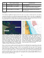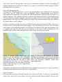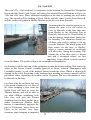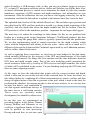
1
Fairway
Issue No. 32
Spring 2011
SCG
MTNG
Newsletter of the Small Craft Group and the
Marine Traffic & Navigation Group
Contents
Forthcoming events
Chairmanʼs Report
London International Boat Show
Damage to bridge equipment
Aids to Navigation Review 2010
GPS jamming and the benefits of eLoran
Electronic Navigation Workshop
Small Craft Group Annual General Meeting
If your electronic chart display is wrong - who is to blame?
Fly / Sail 2011
TeamSurv – helping to create better charts
The benefits of electronic charts
Pakefield Coastwatch
Old chart data problems
Boat lost on six mile voyage
EGMDSS VET learning
Stop Press – IHO ask for help
1 Kensington Gore
LONDON SW7 2AT
Tel: +44 (0)20 7591 3130 Fax: + (0)20 7591 3131
www.rin.org.uk
Registered Charity No. 1117254
2
3
4
5
6
8
13
17
18
22
23
25
27
29
30
30
32
Fairway No. 32
Spring 2011
Any facts stated or opinions expressed in this newsletter are the sole
responsibility of the contributor. Neither the Royal Institute of Navigation nor the
Editor can be held responsible for any injury or loss sustained in reliance
thereon.
As an Editor with space to fill I usually find that it is easier to obtain information,
articles and reports of meetings that are more relevant to those members whose lives
revolve round large ships rather than with small craft. In this edition, however, there is
far more about small craft than there is about ships. Could this be something do do with
the recent flurry of activity by the Small Craft Group? Whatever it is, I trust that both the
SCG and the MTNG will find something interesting to read.
There are some illustrations in the black and white paper version that are not easy to
understand, for which I apologize. I tried redrawing them in black and white but the
authors requested that I use the coloured originals.
John Hasselgren, Editor. 01277 231185, [email protected]
Forthcoming events
11th. and 12th. June 2011
Fly / Sail weekend, Great Oakley Airfield, Harwich, and
Shotley Marina.
For details of this fun event, see below.
14th. to 16th. June 2011
SeaWork International Exhibition,
Canary Islands Fruit Terminal, Southampton Docks.
Although it is unlikely that the Institute will be
exhibiting, members may still wish to visit.
16th. to 25th. September 2011 PSP Southampton Boat Show,
Mayflower Park, Southampton.
The Institute’s stand has moved into the Solent Hall,
where all the Sea Schools exhibit.
Robin Payne is organizing the stand manning list. To volunteer for stand
duty contact him at [email protected], 01243 512503.
17th. November 2011
Small Craft Group / Royal Thames Yacht Club joint
meeting. RTYC, Knightsbridge, LONDON SW1.
The topic will be “Crossing Shipping Lanes” with a
panel of speakers.
Please note: This date of 17th. November is still to be confirmed. Readers should check
the Institute’s web site nearer the time for the latest information. Ed.
2
Chairman’s Report
I am delighted to introduce the two new members of the Small Craft Group Committee: Kathy
Hossain and David Andren. Kathy Hossain FRIN has an MSc in Navigation Technology and
has spent the majority of her career at Trinity House working on strategic planning, regulation
and user requirements in the maritime aids to navigation field. David Andren is a former Civil
Servant who, in his rôle as chairman of the Alde and Ore Association, fought hard to try to
retain the Orford Ness Lighthouse operations. Stepping down from the committee after more
than a decade’s service is Carl Calvert FRIN, who, when working as Geodetic Adviser to the
Ordnance Survey, was instrumental in securing support from Trinity House for the adoption of
the geodetic datum ETRF89 by the General Lighthouse Authorities and subsequently by the
UKHO. The Committee now comprises Peter Chapman-Andrews (ex officio), Peter Eddis
(Hon Sec), John Hasselgren (Editor, Fairway), David Andren, Paul Bryans (who recently
organized the excellent Electronic Workshop at the Royal Southern YC), Roger Grimsdick
(liaison initiatives), Kathy Hossain, Simon Jinks (editorial and promotions), Keith Langridge
(media and website) and myself, Cynthia Robinson, as Chairman. The Small Craft Group is
grateful to all its committee members, past and present, for their generous help and support –
all given on a voluntary basis.
At the SCG AGM on 17 March 2011, I reported that our activities continue to address the
identification and adoption of the most important and appropriate developments in navigation,
plus the safer sharing of our crowded seas. This issue of Fairway has reports on our recent,
well-supported Electronic Navigation Workshop in Hamble and the talk in London about the
accuracy of electronic charts by Chris Smith, Technical Advisor, UKHO. RIN HQ now has an
updated portfolio of electronic charts for perusal by members, through the good offices of the
UKHO and Euronav. Those wishing to build their skills and understanding of the strengths and
weaknesses of electronic charts are particularly encouraged to spend some time practising in
the benign conditions of South Kensington before putting to sea.
The Small Craft Group is also delighted to be assisting The General Lighthouse Authorities
(GLAs) in their current work on identifying the most helpful aids to navigation for the future.
To date, our work on this joint initiative has stimulated more than 400 responses from those
concerned about best practice in the use and development of electronic navigation, AIS (B),
radar and other aids to navigation. The GLAs have an increasing understanding of the wishes
of those operating and navigating ships (and paying Light Dues), but now wish to hear the
views of small craft users. The SCG offered to assist Trinity House in securing feedback from
those that put to sea in small vessels, whether for leisure, training or work. Trinity House is
already reviewing the initial responses and we hope that the results of this work will be
published in due course. In the meantime, we are continuing to collect responses, so please
complete the questionnaire (which you’ll find through the ‘What’s New’ section of the
homepage of www.rin.org.uk). Thank you.
It appears there has been much misunderstanding amongst members of the public about
potential changes to the MCA’s services. At an excellent meeting of RIN’s Solent Branch, Vice
Admiral Sir Alan Massey, MCA Chief Executive, explained that the current, ubiquitous
staffing model employed at coastguard centres sees some groups run off their feet during
summer daylight hours, whilst others have spare capacity and may not be practising all their
3
skills. The proposal is to continue to monitor calls through the current comprehensive array of
aerials, then secure a local search and rescue response via a couple of state-of-the-art, wellstaffed control centres. The MCA’s extensive, and invaluable, resource of local volunteers will
be retained.
As Spring merges into Summer, we are pleased to invite you to turn theory into practice and
navigate to our popular Fly-Sail event in Harwich in mid-June. On arrival, the air and sea
navigators swap tall tales, fly, sail and, well … party! Do join us if you can.
Cynthia Robinson
London International Boat Show
Held at ExCeL in January, the Institute had a stand, kindly funded by a grant from
Trinity House, right opposite the RNLI. The main features on it were a slide show of
boating scenes, the redundant Decca Navigator which still attracted interest and a porthand buoy kindly donated by corporate member Hydrosphere UK Ltd. John Barfoot
FRIN had made the latter correctly flash four times every 15 seconds. With three
members on duty each day there was time for them to get off the stand and see the show
as well as spending time
talking to visitors and handing
out magazines and newsletters.
A major initiative on the stand
was a questionnaire, a cooperative venture in which the
Small Craft Group assisted the
General Lighthouse Authorities
to ascertain the views of
yachtsmen about AIS and
radar. Visitors to the stand
were asked to complete this
form and were also able to see
that the Institute is well placed
to make their opinions known.
More than three hundred forms
were completed and one was
drawn at random at the end of
each day to be given Associate
Membership for eighteen months. The completed questionnaires have been forwarded to
the GLA for them to analyze the answers and, once they have done so and released the
results, they are likely to be available to the Institute.
The overall impression of the Show was that it was not well attended. ExCeL has been
extended to the east and the Boat Show pushed along in that direction, leaving space at
the west end. This space was filled for the final three days by the Outdoors Show and the
4
Cycle Show, one ticket giving access to both these and the Boat Show. Rarely did the
Boat Show seem crowded; at times it looked empty. Also there were some notable
absences amongst the exhibitors. The MCA haven’t attended a London Boat Show for
some time and they weren’t there this year, neither were the Hydrographic Office, Force
Four Chandlery nor Plastimo. Perhaps a sign of the times, as is the news that the
proposed Liverpool Boat Show, at which we were to have taken a stand, has been
cancelled. Perhaps, as one member of the SCG Committee insists, Southampton is the
only place to be!
Damage to bridge equipment due to water ingress, MARS 201119
Several of our vessels have reported breakdown of, and damage to, navigation and
communication equipment located on the navigating bridge/wheelhouse. This has been the
result of water ingress through radar antennas/waveguides and cable penetrations on compass
deck (monkey island) or the base of the main or radar mast. If this results in irreparable
damage to vital equipment required for communication or safe navigation, the ship can
potentially become unseaworthy, with all the consequent ramifications. Further, it may entail
replacement of damaged equipment on an emergency basis, which will result in off-hire time
for the vessel as well as the high cost of sourcing new equipment at short notice.
In our fleet, we now require electrical officers (E/O) to examine carefully all radar antennas,
cable penetrations and junction boxes on the compass deck and masts once a month and ensure
watertightness as part of the planned maintenance system (PMS) on board. In addition, the E/O
is required to monitor closely any repair or retrofitting involving such penetrations, to ensure
that watertight integrity is maintained at all times.
Editor’s (of MARS) note:
Experience has shown that leaks through deck plating and penetration can occur even on new
ships, but due to progressive corrosion and wastage this problem can become serious on older
ones. Temporary repairs at sea must be carried out carefully with the full concurrence of shore
management and permanent repairs effected at the earliest opportunity under class
supervision/approval. Apart from malfunction/loss of vital navigation and communication
equipment, such water ingress can pose a serious electrocution and fire hazard. Under some
conditions, damp and condensation in the spaces inside panelling containing electrical
junction/distribution boxes can also cause malfunction in critical equipment and control
circuits.An inexplicable drop in radar performance can often be traced to water in the
waveguide. If the waveguide is warm to touch soon after power is turned off, it is very likely
that water has entered the system. This water must be carefully drained by following the
maker’s service manual (usually by opening the drain provided or the first waveguide section
below the wheelhouse deckhead) and a follow-up check by the maker’s technician should be
arranged at the next suitable port.
Traditionally, cable penetrations used a cement-like mixture to maintain watertightness, but
these are prone to cracking. Nowadays, a variety of synthetic resins, bagged materials and
‘clamp ferrule’ type seals are available as alternatives, subject to flag state/classification
society approval.
5
Aids To Navigation Review 2010
General Background
All sovereign states which are signatories to the IMO Convention for Safety Of Life At Sea
(SOLAS) must make provision for Aids to Navigation (AtoN) in their waters, in accordance
with the general provisions of that Convention. The governments of the UK and the Republic
of Ireland (RoI) have historically done this together – a situation which predates the
establishment of the RoI as an independent state.
The authority to specify, provide, superintend, maintain – and charge for – AtoNs is vested in
three General Lighthouse Authorities who derive their powers and responsibilities from the
Merchant Shipping Acts of each country. The GLAs are:
Trinity House (TH) Northern Lighthouse Board Commissioner for Irish Lights -
covering the coasts of England and Wales
covering Scotland and the western / northern islands
covering Ireland, including Northern Ireland
Each GLA is a wholly independent organization but, because they all do essentially the same
thing to the same international (IALA) standards, there is a very close strategic and working
relationship between the three organizations.
Funding
AtoNs do not come cheap and the UK and RoI have long coastlines compared to, say, Holland
or Belgium. The long held principle of both governments is that the cost of AtoN should not be
borne by general taxation, but by those who have a need for and derive benefit from AtoN –
why should a tax payer in land-locked Walsall pay for a Malaysian container ship entering
Felixstowe?
As the origins of AtoN provision lie in the shipowning community (whereby shipowners used
to individually or collectively provide and maintain private lighthouses to keep their ships off
the rocks), it is a logical – if not always popular – view that funding must be based on ability to
pay as well as the derivation of “benefit”. Therefore, we have a system of “Light Dues”,
whereby merchant ships entering UK and RoI ports pay a charge based on a combination of
their tonnage and the number of times they enter the UK and RoI. The Light Dues are paid into
a central fund called the General Lighthouse Fund (GLF) which is jointly administered by the
Department for Transport and its RoI counterpart.
The GLAs apply to the GLF for both operating funds (for salaries, operating costs, etc.) and
also capital funds (for vessels and AtoN capital infrastructure) – all in accordance with
previously agreed budgets and business plans.
Due to the exploitation of new technologies, Light Dues have reduced or been static since the
mid 1990s. Lighthouses were automated; lights were “solarized”; numbers of AtoN were
rationalized in response to improvements in shipboard navigation systems such as GPS – all of
which resulted in real term cost savings to the GLF. However, once a major technology-led
dividend has worked itself through the system, there comes a time when the cash flowing into
the GLF from Light Dues is not sufficient to meet the cost demands of the three GLAs. This
6
situation was exacerbated due to the reduction in ship calls, and therefore Light Dues income,
resulting from the economic downturn following a decade of relative economic good times for
trade.
Why The Review?
Individually and collectively, shipowners have long resented what they see as the unfair burden
of Light Dues. Now – just when they were in the middle of extremely tough trading conditions
– they were being increased, albeit by a relatively modest amount and for the first time in 16
years.
Additionally, whilst the RoI government makes a direct contribution into the GLF and the UK
government does not, UK shipowners perceive that the Light Dues they pay are subsidizing
AtoN provision in the RoI. This view is based on an assessment of Light Dues collected in
each of the three areas against the cost of AtoN provision in each GLA area.
As representatives on the GLF Advisory Group, the shipowners petitioned the DfT to
commission a root-and-branch review on the whole question of AtoN specification, provision,
and funding. Formal Terms of Reference (TOR) were agreed and the DfT commissioned the
consultants WS Atkins to undertake the review. The author of this article is a Master Mariner
and independent marine consultant, and was brought in to the Atkins team as the nautical
advisor.
The Key Study Requirements Of The Review
In brief, the TOR included the requirement to:
•
•
•
•
•
•
Examine the way that the GLAs operate and identify the extent to which they
meet / exceed IALA standards.
Assess the current and potential level of inter-GLA co-operation with particular
regard to potential efficiencies.
Review the corporate governance of each GLA and comment on the structure /
fitness for purpose of each structure.
Identify, where possible, the potential for efficiencies in terms of shared facilities and
back-office support.
Review the charging regimes for AtoN in other countries, particularly fellow
EU member states, and advise on the suitability of other funding mechanisms
for AtoN provision.
Examine every aspect of the special UK/RoI funding regime, with a specific
requirement to identify ways whereby the UK and RoI might be uncoupled.
Initial Thoughts
We were increasingly aware of a number of factors which, having been adopted piecemeal over
a very long time, added up to a “system” that worked, but pleased nobody! Delving further,
there were some fundamental, but often unanswerable, issues such as:
•
Who is the “user” of the AtoN? Passing coastal ships derive a benefit from AtoN but,
if they are not calling at a UK or RoI port, they pay nothing for them.
7
•
•
•
•
The “user” and the “payer” are not always the same, even for UK and RoI vessels.
Leisure users derive a benefit from AtoN but do not pay. More on this later!
Why is the same organization responsible for “specifying” and for “providing”
AtoN? Surely this is a recipe for self perpetuation and has no incentive for cost
reduction?
To what extent does / should one sovereign state collaborate with or subsidize
another? Certainly, an oil tanker pollution from a grounding caused in part or in
whole by (lack of) adequate AtoN provision, would affect both nations.
Although the AtoN specification process draws extensively on consultation from the
maritime community, many of those consulted do not pay, so the easy and safe thing
to do was to always say “yes” to navaids for which you never have to pay.
The more we looked the more we felt that one could not actually set out to devise a less logical
structure for UK and RoI waters …. yet, the end product works, and works well! The three
GLAs are regarded internationally as the benchmark against which all others around the world
are measured. There has never, in modern times, been a shipping casualty where lack of or
inadequate AtoN provision was a contributory factor!
Outcomes
The study lasted from Oct 2009 to March 2010 and resulted in a 270+ page report with 52
recommendations, mainly of a financial and corporate governance nature. The full report can
be downloaded from the DfT website and it was accepted by both governments and all parties
including the GLAs. It was presented to the UK Parliament by the Shipping Minister who then
invited comment from the wider maritime community.
One of the report conclusions was that the funding of AtoN provision ought to be more broadly
based, and bring in a contribution from a wider range of mariners who derive a use from AtoN.
The RYA made representations as to why leisure users should not be charged for AtoN, the key
elements of which were the difficulty in collecting any fees / dues / taxes given the lack of a
centralized leisure craft register. The DfT were always mindful of (what they called) the Dog
Licence Problem, where it costs more to administer a charge than any resulting benefit!
The:
•
•
•
representations of the RYA,
lack of appetite on the part of the DfT
focus on other recommendations within the Atkins report
have resulted in decision by the UK government to leave the basic charging regime untouched
…… for the present time!
On 26th July 2010, DfT Junior Minister Mike Penning’s statement said:
“In this difficult economic period the Government also wishes to provide long term stability
and reassurance, both for light dues payers in the level of charges they face and for the general
lighthouse authorities so they can plan effectively with budgetary stability. The responses
received to my request for comments on the Atkins recommendations suggest that there is little
appetite to make major changes to the structure and scope of light dues payable by ships
8
visiting our shores. I do not therefore intend to change the basis on which light dues are
currently charged, although I will continue to work with all interested parties to seek an
equitable means of ensuring that all those who benefit from the provision and supervision of
marine aids to navigation by the general lighthouse authorities pay towards their provision
where it is viable, practicable and economic to do so.”
So, where does this leave the thorny old chestnut of yachtsmen and Light Dues? My work here
is done and it is likely that the UK and RoI governments will wish to see the effects of the
other 51 Atkins recommendations before even thinking about another review of AtoN
provision and funding.
However, my opinion – and it is only that – is that the principle of charging leisure users is
undeniably fair, and it is only the practicalities of the collection that present a barrier!
Happy Sailing!
Captain Tom Drennan MNI AFRIN,
Director, Drennan Marine Consultancy Ltd.
[email protected]
GPS Jamming and the benefits of eLoran
Introduction
The General Lighthouse Authorities of the United Kingdom and Ireland (GLAs) provide
marine Aids to Navigation (AtoNs) for the benefit and safety of all mariners. The GLAs are
keen to understand the effect of GPS jamming, and the GPS service denial, on the safety of
maritime navigation and support the development of a resilient means of obtaining position,
navigation and timing (PNT) information.
This article reports on the work completed by the GLAs in investigating the effect of GPS
jamming on typical marine vessels and equipment and reviews both GLA jamming events held
to date.
Flamborough Head Trials
The Flamborough Head trials, conducted in 2008, identified that maritime safety could be
severely affected by GPS jamming. The effects observed on the ship-borne and shore-based
equipment depended upon a number of factors, including the ratio of the jamming and GPS
signals, the distance between the jamming source and the GPS antenna and also whether there
were any obstructions in the path.
From the trial results, three distinct states were identified and are defined in Table 1. These
states correspond to the manner in which GPS fed equipment responded to varying jamming
conditions.
9
State
Ratio of signal strengths
Observed result
1
Jamming signal << GPS signals
Normal operation.
2
Jamming signal = GPS signals
GPS fed equipment provides erroneous data,
some of which is hazardously misleading.
3
Jamming signal >> GPS signals
GPS denied and equipment fails to provide
PNT information.
Table 1: Table describing the effects observed for the three states identified from the results of the
2008 trials.
The Northern Lighthouse Board Vessel Pole Star was used to steam between two known
waypoints through an area affected by the jamming signal. Figure 1 provides a comparison of
an erroneous position reported by the GPS receiver, with the vessel’s true location indicated by
the eLoran positions. In this figure the light blue line shows the path taken between the two
waypoints and one can clearly see the three states described in Table 1.
Figure
1: Google TM
Earth™showing
Plot showing
the
Fig.1
Fig.1 Google
Google Earth
EarthTM Plot
Plot showing the
the reported
reported
reported
positions
from
one
of
the
typical
marine
positions
positions from
from one
one of
of the
the typical
typical marine
marine grade
grade
grade
receivers.
An
erroneous
GPS
position
(red
receivers.
receivers. An
An erroneous
erroneous GPS
GPS position
position (red
(red circle)
circle) isis
circle)
is
compared
to
the
corresponding
eLoran
compared
compared to
to the
the corresponding
corresponding eLoran
eLoran position
position
position
(green The
square).
The
GPS
position
is
(green
GPS
isis reported
(green square).
square).
The
GPS position
position
reported as
as
reported
as
being
inland
22km
west
from
the
being
inland
22km
west
from
the
true
eLoran
being inland 22km west from the true eLoran
position.
(Red
lines
lobe
the
position.
(Redposition.
lines indicate
indicate
the
main
lobe of
of
the
true
eLoran
(Red the
linesmain
indicate
main
jamming
unit
and
position
colours
indicate
reported
jamming
unit jamming
and position
indicate colours
reported
lobe
of the
unitcolours
and position
speed:
<15
yellow
knots,
speed: blue
blue
<15 knots,
knots,
yellow
<50
knots, orange
orange
indicate
reported
speed:
blue<50
< 15knots,
yellow<<
100knots
and
red
>
100
knots).
100knots and red > 100 knots).
<50knots, orange <100knots and red >100knots.
Figure
2: A screen
shot the
of the modified
electronic
Fig.
Fig. 2:
2: AA screen
screen shot
shot of
of the modified
modified electronic
electronic chart
chart
chart
showing
two
positions
reported
from
showing
reported
the
showing two
two positions
positions
reported from
from the
the
demonstration
vessel.The
The
green
dot
the
demonstration
green
dot
the
demonstration vessel.
vessel.
The
green
dot is
is
theiseLoran
eLoran
position
and
true
the
eLoran
andthe
shows
the
trueof
of
positionposition
and shows
shows
the
true location
location
oflocation
the vessel
vessel
within
the
jamming
area
(red
hatched
box).
The
blue
within
the
jamming
area
(red
hatched
box).
The
blue
the vessel within the jamming area (red hatched
vessel
icon
isis vessel
the
GPS
vesselThe
icon
the erroneously
erroneously
reported
GPS
box).
blue
icon is thereported
erroneously
position.
position. The
The line
line emerging
emerging from
from the
the icon
icon is
is an
an
reported
GPS
position.
The
linewhich
emerging
fromas
indication
was
indication of
of the
the reported
reported speed,
speed, which
was given
given as
the
an indication of the reported speed,
over
700
knots.
overicon
700is
knots.
which was given as over 700 knots.
the
2,
and
erroneous
data
can
be
reporting
the received
received
GPS
signals,
State
2, the
andpath
erroneous
datasolid
can blue
be observed
observed
reporting
wandering
State
1 can beGPS
seensignals,
at eitherState
end of
where the
line occurs;
this is wandering
where
the
jamming
strength
is As
much
than
the the
received
from
GPS satellites
and 33the
positions
at
speeds.
vessel
enters
lobe
the
jamming
signal
is
positionssignal
at high
high
speeds.
As the
thelower
vessel
enters
the main
mainsignal
lobe of
of
thethe
jamming
signal State
State
is
GPS
systems
are
operating
normally.
As
the
vessel
approaches
the
main
lobe
of
the
jamming
observed,
observed, this
this isis where
where the
the GPS
GPS signals
signals are
are swamped
swamped the
the jamming
jamming signal
signal and
and the
the receiver
receiver fails
fails
signal,
shown
by
the
red
lines,
it
reaches
an
area
where
the
jamming
signal
is
comparable
with
to
to provide
provide any
any PNT
PNT output.
output.
the received GPS signals, State 2, and erroneous data can be observed reporting wandering
positions at high speeds. As the vessel enters the main lobe of the jamming signal State 3 is
The
The results
results observed
observed during
during these
these trials
trials gave
gave an
an important
important example
example of
of what
what can
can happen
happen to
to
observed, this is where the GPS signals are swamped by the jamming signal and the receiver
onboard
equipment
as
as
onboard
equipment
as well
well
as the
the impact
impact itit can
can cause
cause to
to the
the mariner
mariner durin
durin periond
periond of
of GPS
GPS
fails
to provide
any PNT
output.
jamming
jammingand
andservice
servicedenial.
denial.
10
Newcastle
Newcastle Demonstrations
Demonstrations
Following
Following the
the Flamborough
Flamborough trials,
trials, aa series
series of
of demonstrations
demonstrations was
was conducted
conducted off
off Newcastle
Newcastle
The results observed during these trials gave an important example of what can happen to
onboard equipment as well as the impact it can cause to the mariner during periods of GPS
jamming and service denial.
Newcastle Demonstrations
Following the Flamborough trials, a series of demonstrations was conducted off Newcastle
upon Tyne, on the North East coast of England. These demonstrations were held to
communicate the importance of resilient PNT and the potentially important rôle of eLoran, to a
selected audience. The audience included a number of key decision makers from European and
UK Governments, maritime industry, mariners and other AtoN service providers and enabled
them to observe the effects of GPS jamming first hand. The demonstrations took place onboard
the Trinity House vessel Galatea.
In order to monitor and show the effect of GPS jamming two typical marine GPS receivers, an
eLoran receiver and an electronic chart display were installed in the vessel. The electronic
chart display was modified to enable two positions to be shown at the same time and was used
to compare the reported GPS and eLoran positions in real-time. A GPS jamming unit was
installed in the Galatea and configured not to affect other vessels in the vicinity.
Figure 3: Vessel traffic image from AIS
Figure 3:
3: Vessel
Vessel traffic
traffic image
image from
from AIS
AIS
Figure
monitored by the Maritime and Coastguard
monitored by
by the
the Maritime
Maritime and
and Coastguard
Coastguard
monitored
Agency
(MCA)
AIS
station
Agency (MCA)
(MCA) AIS
AIS station
station at
at Flamborough
Flamborough
Agency
at
Flamborough
Head
during the
the 2008
2008 trial.
trial.
The
effect
Head during
during
the
2008
trial. The
The effect
effect of
of GPS
GPS
Head
of
GPS
jamming
can
be
seen
on
the
erroneous
Jamming can
can be
be seen
seen on
on the
the erroneous
erroneous
Jamming
positions
reported
by
trial
positions reported
reported by
by the
the trial
trial vessel
vessel Pole
Pole Star
Star
positions
the
vessel
Pole
Star
(centre
right)
and
also
on
the
vessel
Dutch
(centre right)
right) and
and also
also on
on the
the vessel
vessel Dutch
Dutch
(centre
Progress (top
(topleft).
left).
Progress
left).
Figure 4: Reported AIS positions of Galatea
showing two passages to and from the jamming
Figure 4: Reported AIS positions of Galatea sh
area. The
AIS to
unitand
failed
safe
didnʼt are
two vesselʼs
passages
from
theand
jamming
report vessel’s
any erroneous
(Image
from repo
AIS unitpositions.
failed safe
and didn’t
www.shipals.com).
erroneous positions. (Image from www.shipals.
Observed
impact
Observed
Throughoutimpact
the demonstrations differential Loran (dLoran) corrections were used to calculate
GPS
positions
reporting
unfeasible
GPS
positions
reporting
unfeasible
speeds
were observed (Figure 2). However, signifi
eLoran position with
an accuracy
of 9m (95%
probability).
subtle errors
errors were
were seen;
seen; errors
errors where
where vessel’s reported position differed slightly from th
subtle
Observed and
impact
location
and wandered
wandered slowly.
slowly. It
It is these subtle changes, with believable positions w
location
GPS positions reporting unfeasible speeds were observed (Figure 2). However, significantly
result
in hazardously
hazardously
misleading
information.
result
GPSposition
jamming
causes
random
and it i
subtle in
errors
were seen;misleading
errors whereinformation.
vessel’s reported
differed
slightly
fromerrors
the true
unpredictability that
that causes
causes concern.
concern.
unpredictability
11
While the
the overall
overall result
result of
of GPS
GPS jamming
jamming in the Galatea was the same as that observed
While
location and wandered slowly. It is these subtle changes, with believable positions which result
in hazardously misleading information. GPS jamming causes random errors and it is this
unpredictability that causes concern.
While the overall result of GPS jamming in the Galatea was the same as that observed in the
Pole Star, there were a few marked exceptions. The Electronic Chart Display and Information
System (ECDIS) onboard Pole Star reported erroneous positions and ultimately failed during
State 3, However, the ECDIS in the Galatea continued to track the vessel’s position due to an
additional feed from the vessel’s gyro, making it more resilient to jamming, in the short term.
The AIS transceiver in the Pole Star reported the vessel’s position erroneously during the first
trial, which was observed from the shore based vessel traffic image provided by the maritime
and Coastguard Agency (MCA) (Figure 3). During the demonstrations in the Galatea, her AIS
transceiver failed safe and did not provide any erroneous positions (Figure 4). These
differences show that the impact of GPS jamming will be different for each vessel and depends
on the model, installation and configuration of the onboard systems.
Conclusions
One can conclude that GPS jamming can significantly affect the safety of maritime navigation,
whether intentional or not.
The main effects observed were:
• The presentation of random errors leading to hazardously misleading information which
could, depending on installation, lead a vessel off course.
• The presentation of erroneous and potentially misleading data to other vessels and shore
based infrastructure.
• The sheer number of alarms on the bridge of the vessel could be disconcerting and
distracting for the mariner.
• The loss of GPS fed systems which can create an unfamiliar bridge situation and remove
safety critical systems from operation.
The loss of GPS or a lack of integrity in the reported information leads to an unfamiliar
situation on the bridge. The crews of the Pole Star and the Galatea were expecting to lose
GPS, are well trained and had primed other systems so they could navigate safely. In real life
there would be no advance notice and the impact on the crew would be more severe.
The GLAs recommend that mariners use all available means to navigate safely, and strongly
support the need to create a resilient means of providing position, navigation and timing
information.
By Dr. Alan Grant, Dr. Paul Williams and Dr. Sally Basker,
The General Lighthouse Authorities of the United Kingdom and Ireland.
Reproduced by kind permission from the Northern Lighthouse Board Journal, Summer 2010.
12
Electronic Navigation Workshop
Following its successful Electronic Navigation Workshop in 2009 the Small Craft Group
repeated it in 2011 at the Royal Southern Yacht Club at Hamble. With the experience gained
from the first event, Paul Bryans assembled a selection of speakers from amongst the various
manufacturers but limited them to two main topics, chart plotters in the morning session and
radar and AIS in the afternoon.
Dag Pike FRIN ably chaired the event and helped the speakers to keep to their allotted time,
with questions saved to the forum held just before lunch, and again at the end of the day.
Following a welcome from Fiona Pankhurst on behalf of the Royal Southern Yacht Club the
day was up and running.
Nick Meadow from Garmin gave a very brief history of the company and the fields in which it
operated, in cars, walking and orienteering and aviation, besides its marine side. The marine
cartography is Bluechart G2, which is produced by digitizing standard Admiralty charts. Their
latest chartplotters are capable of showing not only the chart but also 3D rendered views, both
as a fish eye or a mariner’s eye view. The screen can be altered for daylight and night time
viewing. Also available is a satellite image overview, complete with guidance, a tidal flow
indicator and a nautical almanac. Dangerous spot soundings, shown in red, can be set, as can
depth shading contours and buoys can flash their correct sequence. A route can be run directly
from the start to the finish of a passage, then pulled to avoid any dangers that the straight line
crosses; this can even be done automatically once the draught and air draught of the vessel
have been entered.
Lance Godefroy from Navionics and Dag Pike then spoke of the possibilities of mobile devices
such as iPhones and iPads. Dag talked of some of the chart Apps available from Navionics for
these devices which many people now have. The standard iPhone GPS is not sufficiently
sensitive to be used below decks, but an App is available to show the reliability of a GPS
position. Weather forecasts are available on these devices, as is AIS information, rather slowly,
of ships in the vicinity. Finally, said Dag, although they are not waterproof and have limited
battery life, they can double as a depth sounder by being tied to a piece of string and dropped
overboard! Lance Godefroy took over and reminded the delegates that most people now have a
smart phone that is capable of much more than making phone calls. As well as the navigation
capabilities outlined by Dag, these can help make boating more fun. Anticipation of passages
can be helped by the ability to plan anywhere and at any odd moment. These plans can be
shared with friends or crew, either directly on email or via Facebook or Twitter. After a summer
cruise photographs can be shared by the same methods. User Generated Content allows users
to upload information they have identified to charts and almanacs to correct them, information
which can then be downloaded if desired by other users of the system. Freshest Data is a
method whereby registered purchasers of Navionic charts from January 2011 will be able to
download the latest corrections for one full year.
Steve Arnott of MaxSea spoke in favour of using a PC on board as an alternative to a dedicated
chartplotter. A few years ago PCs were not suitable for use afloat, being susceptible to both the
shocks from movement and water. Now, though, there were special versions made for use in
this tough environment. The obvious benefit here is that the PC is very versatile and can
13
perform other tasks such as downloading email and accessing the internet. If one is to be kept
on board it can make sense to use it for navigation. It will frequently have a larger screen than a
dedicated chartplotter, making it easier to split the screen to show different information such as
radar, AIS or a satellite view in different windows. Depending on the software chosen, it may
be easy to use or it may need the user to learn about it. However, using a PC will allow the user
to choose the cartography they wish, either raster or vector, without being limited to that
selected by a chartplotter manufacturer.
Chris Greenham, Navico / B & G, was in favour of overlays as opposed to split screens for
displaying several sets of information. The chartplotter was designed as an aid to navigation.
Information overlays are intended to show optional features. It is probably possible to show as
many as twenty-five different overlays on most chartplotters. These include a trail history,
routes, waypoints and range rings, points of interest with photographs, shaded relief and 3D
views. Perhaps, though, those of greatest use are both AIS contacts and radar. Overlaying radar
onto a chart makes the radar picture much easier to interpret. Weather data is another
possibility, together with tacking angles, using the actual or apparent wind, polar tables and lay
lines showing when to tack to reach a destination.
Simon Jinks of RIN sounded a note of caution in suggesting that yachtsmen still needed to
keep their paper charts. Chartplotters, when first switched on, are likely to throw up a warning
that the equipment and software should not be relied upon for navigation, and that it is only an
aid. The paper chart is large, which makes passage planning easier, without all the zooming in
and out required on a chartplotter. There is a perception that satellite navigation is very
accurate, but what confidence can we have in it? We have to consider the date and accuracy of
the survey and the datum to which the chart is linked. He suggested we needed to give any
satellite derived position a reality check by looking out of the window.
Hugh Agnew presented the view of the racing navigator. Here, the navigator has become a
controller of complex on board IT systems. This includes data logging and analysis, including
load monitoring for safety limits, performance analysis, prediction, sail selection, boat
modeling of heel, keel, rudder and water ballast. Instrument control and calibration are part of
his remit, as well as tides and currents, route planning and weather routing. Unfortunately the
tactician in a racing yacht, due to the use of electronics, now believes he is a navigator as well.
Electronic charts, Hugh said, were riddled with errors, including simple spelling ones. Showing
examples he told of the island of Saba shown with a South Cardinal mark which, on altering
the scale of the chart, changed to a West Cardinal mark. Other islands used as race turning
marks can be shown to be a mile out in position. In the Flinders Island tragedy, the crew on
deck told the Skipper and Navigator they could see the rocks but the electronics showed that
the vessel ought to miss them by 150 metres.
To end the morning session, Richard Falk, RYA, and Peter Everard, RNLI, led a panel
discussion. We were reminded of recent tragedies like Flinders Island, where the HDOP of the
GPS signal changed from 1.2 to over 6 due to a poor cut from the satellites for over 35
minutes, giving a GPS position error of 250 metres. In another case, Cork Clipper hit rocks that
were accurately shown on both paper and electronic charts, but were two layers deep in the
chartplotter menu. Worries expressed by the delegates were the possibility of problems caused
by autorouting, the ageing and potential for failure of GPS satellites and, particularly, the
14
difficulty of updating electronic charts.
Following a break for a very ample cold buffet lunch, Derek Gilbert of Raymarine completed
the section on chartplotters with a description of the benefits and use of their thermal imaging
camera. Stressing that one piece of information is of some help, but adding more improved the
picture, he went on to remind us of the need to look around as well. However, this didn’t
always work during the hours of darkness, but a thermal imaging camera could still add vital
information. Working by showing temperature differences, it could be used to aid visual
navigation at night, as an aid in man-overboard situations or to monitor the engine room for hot
spots. It could also improve daylight visibility by eliminating glare from sunlight.
The topic now changed to AIS and radar with Paul Sumpner of Digital Yacht stating that AIS
was continuing to develop. Commencing with Class A which is mandatory for all vessels over
300 tons, it transmits information alternately on two VHF channels, thus limiting its range to
that of VHF radio. Static information transmitted includes the vessel’s name, IMO number and
MMSI, and its destination. Dynamic information given is the vessel’s position, course, speed
and, in some cases, rate of turn. An early problem was that, to comply with demands for early
introduction from the USA, many ships were fitted with a Minimum Keyboard Display (MKD)
which shows received signals on a three line alphanumeric display, the bridge team having to
scroll down to view any other contacts, and then needing to plot these contacts to obtain a
relative position. They are better shown on a visual display such as a chartplotter, PC or radar
screen. All new fit radar installations in SOLAS vessels since 2008 have been required to show
AIS contacts. For yachts there are receive only sets, either single channel, which alternate
between the channels, or dual channel; these can have their own screen to display the
information or can be designed to feed a chartplotter. There is also Class B AIS specially
intended for non-SOLAS craft that wish to transmit their position, course and speed to others.
Once a contact has been detected it can be selected and the relevant information displayed, thus
giving, amongst other things, the name and MMSI for radio contact if desired.
Steve Monk of Da Gama Navigation dealt with the requirements for superyachts. These
covered the need to carry GMDSS, Inmarsat and VHF communications as well as Navtex. A
listening watch was required on VHF Ch. 16/13/DSC(70), MF 2182 and 2187.5 kHz. The
navigation lights fell into a different category from smaller yachts and there was a legal
requirement to carry an echo-sounder, GPS, gyro-compass and radar. With the majority of
these vessels having enclosed bridges there was an increasing number of screens on display.
This tended to discourage looking out of the window. Most of the screens rely on GPS, which
can be jammed. Radar, however, is an independent system and if it is overlaid on the chart and
they agree with one another it gives great security and confidence in the position. If full ECDIS
is carried, and training as specified by IMO received, paper charts need not be available.
However, most superyachts use electronic charting systems (ECS) suggesting that paper charts
are also necessary. To navigate safely needs a stopwatch, an echo-sounder and an eyeball.
Everything else is a bonus!
Peter Goddard from Compliance Maritime Ltd. took us on to radar reflectors, explaining that
as the majority of the incoming radar signal was scattered rather than reflected very little went
back to the transmitting ship. It is expected at IMO that a 5 kW transmission will result in only
micro-watts being returned. Graphs were shown giving the probability of being detected. A
15
50% chance was considered good and will usually show on the radar screen 5 times out of 10
sweeps. A consistent echo on the screen is needed to trigger the Automatic Radar Plotting Aid
(ARPA) which can trigger an alarm to the OOW. Sea clutter and rain clutter will tend to hide a
poor target, and a yacht is frequently a poor, inconsistent target. Increased wind speed will
introduce oscillation of the received signal reducing its effectiveness. On reflector shape, a
sphere is the most effective, but least efficient shape – it will always reflect some energy back
but it will be very weak. A flat plate is the most efficient, but also the most unreliable. The
trihedral corner reflector, with horizontal and vertical angles of 60˚, represents the best
compromise between effectiveness and efficiency. Better than any of these is the radar target
enhancer which detects the incoming signal then returns it. This gives a much more consistent
return, thus triggering the ARPA.
The final speaker was Chris Hoyle, a Southampton Pilot. His view was that AIS, especially
Class B, could be too much of a good thing, especially in the Solent on Round-The-IslandRace day. Showing a picture of the ECDIS with all these contacts, he explained that it was
impossible to see the chart, so they would be filtered out. The course and speed of most yachts
vary too much to allow any prediction of their future position, making an accurate Closest
Point of Approach (CPA) impossible to calculate. Pilots prefer to work by looking out of the
window and using radar, rather than studying electronics which are probably ground stabilized
rather than water based. He also commented that Admiralty Courts only refer to the ColRegs
and that AIS should only be used to identify vessels. How to use AIS, especially Class B? Chris
suggested that it can usefully be employed in clear, unrestricted waters, preferably between
sunset and sunrise, or in visibility that is restricted to less than two miles. Otherwise, receive
but do not transmit, especially in crowded waters like the Solent where they are shared
between yachts and large ships.
During the final discussion session several points were raised. These ranged from the need for
some standardization from different manufacturers (aviation layouts are similar, 32 ECDIS
manufacturers – all different, Nautical Institute trying to establish a Standard Mode button),
head-up displays to allow electronics to be seen without missing the exterior view, the concern
that if AIS Class B is filtered out all alarms associated with that signal may also be defeated,
the attitude of the OOW when detecting a yacht by AIS Class B, and the possibility of an AIS
virtual “warn-off flare”. Summing up the day Dag Pike said that he felt the delegates were
concerned that chartplotters were being used because they were there and that the
manufacturers appeared to be trying to outdo one another with more “bells and whistles” rather
than concentrating on basic navigational needs. However, we should accept that electronic
navigation is here to stay, that it makes things easy, embrace it, but remember that it is only an
aid and that we should check with all available means.
(I would like to acknowledge the assistance given in reporting this event by Robin Payne who
supplied notes to augment my own. Ed.)
16
Small Craft Group Annual General Meeting
Opening the AGM at the Royal Thames Yacht Club on 17th. March, Chairman Cynthia
Robinson welcomed the members present. The minutes of the previous meeting were
swiftly approved before the business moved to the election of members of the
Committee. Cynthia explained that Carl Calvert FICS, FRIN had felt it necessary to
stand down due to pressure of other commitments; in fact, he was unable to be present at
the meeting as he was giving expert evidence in court. First being elected in the late
1990s, Carl had done much work on geodetic datums in the change over of charts from
OSGB36 to WGS84.
Two potential members of the committee were introduced to the meeting, Kathy Hossain
and David Andren, both of whom had attended the earlier committee meeting as
observers. Robin Payne proposed that the complete list of persons submitted be elected
en bloc. This was seconded by Richard Smith and accepted by the members present. The
full committee is thus:
Cynthia Robinson, Chairman.
David Andren
Paul Bryans
Peter Chapman-Andrews (ex officio)
Peter Eddis (Secretary)
Roger Grimsdick
John Hasselgren (Editor, Fairway)
Kathy Hossain
Simon Jinks
Keith Langridge
Moving on to her Chairman’s Report, Cynthia said that the Group had been busy during
the previous year with a talk on eLoran, the Fly/Sail weekend with GANG at Gosport
and stands at SeaWork and the Southampton and London Boat Shows. A visit had been
made to Trinity House in London and this had led to the Group co-operating with the
GLA assisting it to establish the views of small craft operators as opposed to its more
usual contacts with SOLAS craft; this saw us running a survey for the GLA on our stand
at the London Boat Show. At that show, also, the Princess Royal had presented to the
RYA Yachtmaster of the Year the cup donated by RIN. More recently, the second, very
successful, Electronic Navigation Workshop had been held at Hamble.
For the future, Cynthia went on, she hoped we would both continue and lead the
dialogue between manufacturers and users of electronic navigation equipment and
expected to again run the Electronic Navigation Workshop. She also aimed that the
Group would keep in touch with bodies like Trinity House, the MCA, UKHO and the
RYA. Future events planned were a repeat of the Fly/Sail weekend, this time on the East
17
Coast, stands at the Southampton and London Boat Shows and the two meetings, Spring
and Autumn, at the Royal Thames Yacht Club. Finally, Cynthia explained the way in
which the work was divided amongst the members of the Committee, detailing the jobs
each undertook, although stressing that volunteers were always welcome, even if not on
the Committee.
Following the AGM a short forum was held on the topic of how to persuade navigators
to have a back-up to their electronics. One suggestion from the floor was to insist that a
log be kept, something that is only a legal requirement for SOLAS vessels. Several
members insisted that they kept a log, not only to provide a fall-back to electronic
navigation, but also to provide future interesting reading in old age. Another view was
that we should forget the distinction between traditional and electronic navigation. There
should just be navigation, by all available means. One Yachtmaster Instructor said he had
had interesting results by surreptitiously unplugging the GPS antenna during his courses.
Another reported that his Club ran an annual training day for its Skippers, although this
was to allow them to Skipper a Club boat. Moving on, there was some concern that the
Institute was mostly preaching to the converted and that a way needed to be found to
influence those who were not members, did not attend meetings nor go on courses.
If your electronic chart display leads you astray – who is to blame?
Chris Smith, Technical Advisor, UKHO
Starting by warning the audience not to believe everything they read in the press about
electronic navigation systems, Chris Smith quoted some examples where the nonspecialist press had made exaggerated claims for these types of equipment. However,
they were becoming very sophisticated, with increased functionality. Chart display
systems can frequently overlay data such as weather or satellite images and show three
dimensional views of the sea bed.
So what can go wrong? Chris explained that these systems consist of several elements,
all of which could potentially cause a problem. Listed, these are the hardware, its
installation, the power supply, the display software, the chart, the positioning source and
the user, including his or her knowledge of the system with familiarization both of it and
its procedures. Human behaviour, a desire to believe the system and the position it is
providing to be correct, is also a problem. Chris quoted the case of the Royal Majesty, a
cruise ship which grounded on the Nantucket Shoal due to a break in the cable between
the antenna and the GPS receiver. The vessel had been proceeding on autopilot for
several hours with the GPS unit providing only Dead Reckoning positions, had been
offset several miles by the tide and nobody on board had thought to check the position
by another means. Most causes, though, are likely to be a combination of two or more of
the possible errors.
A comparison was then drawn with in-car systems and their potential to lead people
astray. With these, despite noise in the very weak received GPS signal, the car is always
18
shown on the road, never off it. This is down to software that knows that the car should
be on the road, so puts it there. Roads as such don’t exist at sea. There is also the fact
that drivers put too much reliance on the routes given, hence lorries stuck in unsuitable
narrow lanes. Incorrect user input will lead to errors, such as the Swedish tourists who
were directed to the wrong end of Italy after misspelling Capri.
Moving to the marine side of the matter, we were told that marine electronic charts were
much more complex than in-car ones. For a start there were systems and charts for both
SOLAS ships and for leisure craft. Electronic Chart Display and Information Systems
(ECDIS) would soon become mandatory for large ships, and were regulated by IMO
performance standards. Leisure vessels are under no compulsion to fit chartplotters and
the manufacturers don’t have to abide by specific standards. For a commercial vessel to
give up paper charts, it must fully comply with ECDIS requirements, and the electronic
charts installed in the ECDIS have to be issued by an official Hydrographic Office.
At the London Boat Show there had been many exhibitors supplying electronic charts.
Most of these would be based on the equivalent paper chart produced by a Hydrographic
Office, and could be either raster charts, basically a photographic image of the paper
one, or vector versions, where individual chart features are captured and held in a data
base, also derived from the paper chart. The amount of reliance that may be placed on a
chart will be determined by the accuracy and date of the survey on which it has been
drawn, the horizontal datum on which it is based (when comparing with GPS positions)
and whether or not it has been updated with the latest information. This is easily checked
on a paper chart, but may not be so easily found on a electronic version.
So, can the chart be wrong? Mistakes can be made by all chart compilers, but most
deficiencies are likely to be due to the incompleteness of, or inaccuracies in, the
underlying survey, which in many parts of the world is still insufficient. Most official
vector charts (Electronic Navigational Charts - ENCs) issued by HOs for use on ECDIS
contain symbols that allow the quality of the survey data to be visible on the chart
display. The symbols are know as CATZOC (category of zone of confidence) and
display as stars within a triangular or lozenge shaped outline, the more stars the greater
the reliance that can be placed on the information being displayed. However, it must be
remembered that a survey is a snapshot in time and all charts need keeping up to date.
Some problems can be met due to the need to zoom in and out on a chart plotter,
something never done with a paper chart. If the electronic chart is a raster copy of the
paper one the image will be more difficult to see as the system zooms out unless a
smaller scale chart is loaded. Similarly as the image is zoomed in the symbols will get
larger and the image will eventually deteriorate unless a larger scale chart is loaded.
With a vector chart, which is built up in layers, the image does not degrade in the same
way but details may be obscured by things like titles and channel names which are
automatically placed on the chart by the software. Because the image does not
deteriorate as it is zoomed in, it is possible for the user to get a false impression of the
accuracy of the data.
19
Chris Smith then showed examples of electronic charts and explained some of the ways
that they can lead you astray. The image of the Admiralty Raster Chart Service (ARCS)
chart no. 967 of Palawan, gives a feeling of its limited accuracy through the ‘fathoms’
colours, its hachured topography and dotted contour lines – and this reflects the 1865
survey on which it is still based. It is unlikely that a mariner will entirely trust the GPS
position indicated by fine cross-hairs on a chart like this. However the equivalent
Electronic Navigation Chart (ENC) of the same area, despite having little topographical
detail, looks more modern due to the ‘metric’ colours used and the certainty with which
the contours are displayed.
When coupling the chartplotter and the chart, it was explained that systems using vector
charts give great flexibility in use, with the ability to tailor the chart display to the
particular vessel and its type of operation. It allows seamless zooming and moving to
adjacent charts, insertion of suitable depth limiting contours and inclusion or exclusion
of chart details. However, the user needs to be familiar with the system and its
limitations. And the larger the screen size the better.
Moving on specifically to ECDIS we were shown typical displays of the Solent and
Southampton Water area. First up was the Base Display Mode. This showed the land,
shallow water and dredged channels only. Whilst very clear, it is the minimum
information allowed to be displayed on ECDIS (and is not supposed to be sufficient for
standard navigational tasks). The Standard Display Mode came up next, with more
information, but still no soundings. The chart used a simplified symbology rather than
standard paper chart symbols. This is mainly due to the much lower computing power
available when the concept was first envisaged in the 1980s. Finally we saw the Full
Display Mode. This showed everything including the CATZOC star symbols indicating
the quality of the survey on which the chart was based. However, it looked very busy
and cluttered and it would be quite easy to overlook some of the detail.
All ECS and ECDIS are complex software based systems. This gives a potential for
implementation errors and the user should ask what testing has been done and what
standards have been adopted? A chart was shown of the area close to Dover with a ten
metre safety contour set. The area included a wreck that had been swept with a depth of
1.8 metres over it, quite visible on the Full Display. On changing to Standard Display the
wreck disappeared, although the ten metre safety contour round it was still visible. When
the safety contour was changed to a depth of five metres both the wreck and the contour
round it were not to be seen. However, it was noted that if a vessel was heading towards
this area the system would still throw up a warning! This problem was caused by a
software implementation fault on a particular piece of equipment, subsequently fixed,
but an indication of the types of problem that can exist.
Another example of anomalous display shown was of the Mozambique Channel. Most
oceanic charts are at the scale of 1:3,500,000. In the screenshot shown there were two
small islands and when panning and zooming the display the automatic name placement
could put the name of the channel right across them, making them difficult to see. Also,
20
contours take precedence in display over land features and again at some zoom levels the
depth contours can obscure these islands.
In a further example a yachtsman sailing on the west coast of the USA noted that he had
nearly run into a small islet (it being obscured by the mast and sail) because it didn’t
show on the chart plotter unless the display was at maximum zoom, which given the
small screen gave virtually no warning of its presence. The yachtsman conceded it was a
lesson learned and that he had “trusted the chartplotter too much”.
GPS normally gives a very accurate geographic position, but referred to what? It may be
an illusion of accuracy when considering the vessel position against the detail on the
chart; especially where it is a chart based on an old survey or where the chart datum
cannot be accurately referred to WGS84 without re-surveying. Many chartplotters apply
a blanket average datum shift for a wide area which may be acceptable in mid-ocean but
is just not accurate enough when entering harbour. GPS itself is susceptible to system
errors, to both natural and deliberate interference. These can be mitigated to an extent by
the use of differential GPS, but it is better to cross check using other positioning systems
and it’s always essential to use visual references to ‘ground truth’ what the chart-plotter
shows. The tragic case of the racing yacht Shockwave which ran into Flinders Island
with the subsequent loss of two crew members a few years ago may well have been at
least partially due to over-reliance on the accuracy of GPS at the time
Chris Smith advised us of some simple steps to take:
• Check the latest information from the supplier of the system and the charts.
• Knowledge of and training in the procedures are necessary.
The CFL Performer grounded on the Haisborough Shoal. Her crew had been
trained to use the equipment, but were changed at short notice. The route had been
changed from the original passage plan whilst en route to save an hour at the port
of destination and the appropriate scale chart had not been inspected and the ‘look
ahead’ feature to warn of dangers had not been set.
• Do not be over-reliant on electronics. This can lead you into a false sense of security!
It looks modern and is on screen – it must be right!
It makes navigation easy.
Most of the time it is fine!
• Do not become a “monitoring” navigator.
Don’t rely on a single source of information – cross check!
So, who is to blame? The answer is not simple, whilst it could be a single component in
the navigation ‘system’ the hardware, the software, the chart or the user it’s much more
likely to be a combination of these components that in the end lead you astray. The only
answer is to stay alert and use these systems within their limitations – otherwise the only
winners are likely to be the lawyers!
21
Fly / Sail 2011
This year’s Fly / Sail weekend, a co-operative event between the General Air Navigation
Group and the Small Craft Group, will take place around Harwich Harbour in Essex on
11th. and 12th. June. Plans, although incomplete at the time of printing, are well under
way. The aircraft will be landing at Great Oakley airfield, some 4 miles from Harwich,
and the yachts will gather in Shotley Marina across the river from Harwich.
Assuming that the weather agrees to cooperate the plan is for the sailors to
cross to Harwich in the ferry that runs
from Shotley to the Ha’penny Pier in
Harwich, then travel to Great Oakley to
join the airmen round about lunch time
on Saturday. The afternoon should see
all those who wish to taking to the air
over the Harbour. The whole group will
then return via the ferry to Shotley,
where a certain amount of socializing
will take place during the evening. The
Marina has a bar that serves a decent
Shotley Marina lock with floating fenders and cleats.
pint and a restaurant where, on first
enquiring, I was offered a private upstairs
room for dinner. The yachts will provide overnight accommodation.
On Sunday it will be the turn of the yachtsmen to take the airmen sailing. This can be up
either of the Rivers Orwell, towards Ipswich, or Stour, towards Manningtree and
Constable country, or out of the harbour down towards the Naze. Which is chosen will
depend on the wind. Returning to the harbour those needing to return to aircraft will be
put ashore either, depending on weather, on the Ha’penny Pier or in the marina to cross
to Harwich in the ferry.
For those who do not know the area
it has much of interest to see. First of
all, those bringing a boat from the
South Coast will have to cross the
Thames Estuary and will be able to
see what offshore windfarms look
like; they will pass the Thanet
windfarm and see the London Array
under construction. Shotley Point
marina is immediately opposite the
port of Felixstowe, where there are
likely to be several very large
container ships bringing in imported
Shotley Marina with the Port of Felixstowe in the background.
22
goods. Also opposite is the historic town of Harwich where Trinity House have their outof-town headquarters and their buoy yard. The buoy laying vessel Patricia may be
alongside Trinity Pier. Just up the River Stour is Parkestone Quay where ferries to the
Continent arrive and depart. For those of you who were brought up on Arthur Ransome’s
“Swallows and Amazon” books, two of them are set in the immediate vicinity. “We
Didn’t Mean to go to Sea” starts just up the River Orwell at Pin Mill, before the children
in Goblin anchor, firstly off where the marina now is, and then on The Shelf before
drifting out to sea in a fog and then on to Holland. “Secret Water” sees the children
dropped onto an island in Walton Backwaters just outside the harbour and left to explore
the area and construct a map. Ransome’s map in this book can still be used to find the
way round the Backwaters even now, some seventy years after it was first published.
Each year Harwich Haven Authority publishes a Yachtsman’s Guide to the region,
mostly to enable yachts to keep out of the way of the large vessels that pass through the
area. All vessels notifying your editor of their intention of participating in the weekend
will be sent a copy; there is no reason why the aircraft could not have one as well.
Members wishing to bring an aircraft to the event should liaise with David Broughton,
[email protected], and those intending to arrive by yacht should contact the
editor, [email protected].
TeamSurv – Helping Create Better Charts
RIN SCG members are, by definition, interested in navigation – for which we use charts,
paper or electronic. But how often do we wish we had a more detailed chart of an area,
or wish that it had been surveyed more recently? Even when the sea bed is rock, there
are many areas poorly surveyed – last year the North coast of Cornwall and much of
Devon was surveyed (the coastline is marked “Unsurveyed” on my chart, admittedly a
couple of years out of date), and an additional 70 wrecks were found. And in the Thames
Estuary or Poole Harbour we know the channels move after every storm passes through.
Unfortunately, there are not the resources to do as much surveying as we would like –
the UKHO reports to the IHO that only about 50% of UK coastal waters are adequately
surveyed. And the UK is one of the better surveyed countries.
TeamSurv is a project to try and improve matters, using crowd sourcing to gather a large
amount of position and depth data from boats as they go about their normal activities,
and process it to produce depth data that, whilst never as good as a full multi-beam
survey, can be better than that found on
many charts. The initial results are
viewable online at www.teamsurv.eu, and
we will shortly have chartlets for
download in areas where we have
sufficient data.
23
To log the data, people can use a
hardware logger that logs NMEA0183
and/or Seatalk to a USB memory stick, or they can use our software logger to run on a
PC, or some PC navigation software such as seaPro and Nobeltec can log the data. Also,
an initial calibration process is carried out to determine the depth of your echo sounder
transducer, separation of GPS antenna and depth transducer, and information on your
instruments. After the calibration, the user just has to start logging when they fire up the
instruments, and take the data ashore to upload to the internet once they leave the boat.
The uploaded data first has all the rubbish filtered out. This includes rogue position and
time data from the GPS, and fixes marked as invalid (e.g. during initial acquisition of the
satellites), and also depth data where the depth sounder has lost the bottom. Then the
GPS position is offset to the transducer position – important for our larger data loggers.
The next step is to reduce the soundings to chart datum; for this we use predicted tide
heights as a starting point (using Smartcom Software’s TideWizard product), but then
correct these using tide gauge data, which is typically sparser than the tide predictions.
We are also implementing speed of sound corrections for the depth sounder, which
varies with the temperature and salinity of the sea water – there can be as much as 6%
difference between the Solent and the Curonian Lagoon used by our Lithuanian partners,
with its colder, almost fresh waters.
As well as applying these corrections, we also have an error budget for the data items,
which includes allowing for the accuracy of the GPS and characteristics of the depth
sounder, and allowances for things like boat motions and the time difference between
GPS fixes and depth sounder pings. Part of the error modeling entails measuring the
actual accuracies achieved by a variety of GPS receivers and depth sounders, the results
of which will be published in due course. I’m just finishing analysing the GPS data, and
there are some surprising results!
At this stage we have the individual data points with the correct position and depth,
which is what can be seen on the web site as the corrected data. To create the charts, we
take things further by combining all of these measurements to remove outliers and then
doing a weighted mean of the data to generate a data grid, which is used as the basis for
producing the chartlets. Accompanying this is also an error analysis, so we can say how
accurate our data is, and comparison of
our data against multi-beam surveys of
the same area as a verification exercise.
These areas are currently under
development, but should be online soon.
In our first year, we concentrated on
recruiting loggers in the Solent, Thames
Estuary, Brittany and Lithuania, so we
could get a significant density of data as
soon as possible to start processing.
Having achieved that, we are now open
24
to data from anywhere – as well as the British
Isles we have also got loggers in Sweden,
Saudi Arabia and the Aegean coming online.
So what are the end products? As well as
producing chartlets that can be downloaded
and printed off, we will also be producing files
in S-57 format that can be used by many PC
based chart plotters. We are also talking to a
number of chart publishers and Hydrographic
Offices about using TeamSurv data in their
products. Also, there is interest from ports and
harbour authorities in using TeamSurv to
monitor depth changes, to know when to
trigger a survey of an area, and in using
TeamSurv to survey areas off the beaten track,
that may be used by small craft but cannot justify the expense of a multi-beam survey.
There are also opportunities in many parts of the world, where they do not have the
resources for a multi-beam survey, and TeamSurv offers a solution that is still good
enough for most purposes.
With charts underpinning most people’s navigation, it would be great to have as many
SCG members as possible join in the project – all you need are a GPS and a depth
sounder with NMEA0183 or Seatalk output. Have a look at the web site
(www.teamsurv.eu), and to take part click on Join In / Apply.
The research leading to these results has received funding from the
European Community’s Seventh Framework Programme under grant
agreement n° 247998.
Tim Thornton, [email protected]
The benefits of Electronic Charts
This paper is written with the Small Craft user in mind. Any member who cares to find
the time has the opportunity to view these Marine Charts in electronic form on the
Institute Library PC. The Electronic Charting System (ECS) software, installed to
display the types of electronic maritime charts, is provided by Euronav Ltd. The version
currently in use is “seaPro 3000” it is able to display the two major types of electronic
charts – raster and vector and much other required navigational information. A dongle
provided by Euronav is required to open the software.
Raster Charts
The first charts in electronic form were Raster Charts produced by scanning a traditional
25
paper chart. They therefore appear familiar to Navigators who started working with
Admiralty, or other HOs’ (Hydrographic Offices) paper charts. The raster chart folio
installed on the Library PC is produced by the UK Hydrographic Office, using their
Admiralty Raster Chart Service (ARCS). Subject to the level of service to which the user
subscribes the ARCS charts, they are supported by a weekly update service. ARCS
charts were introduced in the mid 1990s in advance of vector Electronic Navigational
Charts (ENCs) because the standards for vector charts were not complete, and it was
recognized that the capture of complete and accurate chart data for vector charts was
going to be a lengthy and resource consuming operation for the HOs.
The ARCS image like any photograph is capable of being enlarged or made smaller.
However for a single chart image, when reducing the scale of the display, the chart detail
remains constant so that the image soon reaches the point when detail overlaps and
becomes unreadable. Equally, care needs to be exercised if the chart is enlarged to
greater than “one to one” enlargement as there is no increase in accuracy of the data and
the image clarity suffers. “seaPro 3000” and similar software, in use, moves on to the
adjacent chart, in the course of passage.
Vector Charts
A paper written in 2007 adequately describes the characteristics of the vector chart. (An
electronic copy of this paper is available from the editor.) This database approach makes
vector charts a much more flexible product; for instance the depth data can be rendered
not just as a two dimensional display but, given the appropriate application software,
also as a 3D image. The Institute’s folio of HO’s Electronic Navigational Charts (ENCs)
are produced to IHO standards.
“SeaPro 3000” provides the ability to simultaneously display in separate windows
distant parts of a voyage while retaining full linkage between the separate parts, thus
enabling such measurements as distance and bearing to or from position and destination,
for example. The display can be adjusted for night vision, together with all lights
demonstrating their characteristics. Perhaps of greater importance is the ability to
overlay either AIS or radar. The PC can also be used to show tidal streams and weather
data when required. Finally the benefits of ENCs, are the ease of updating to provide the
greatest accuracy available to the HO, their versatility, and ease of use.
The use of a laptop PC provides the navigator with so much flexibility, but from a Small
Craft stand point a dedicated Chart Plotter is the next best thing. Each Small Craft
provides different challenges such that for some the use of a Yeoman Plotter and Small
Craft paper charts are the answer.
For more information on types of chart and marine regulations see the document “Facts
about Electronic Charts and Carriage Requirements” available for free download from
IC-ENC (www.ic-enc.org) and Primar (www.primar.org) websites.
Bill Sandford, [email protected]
26
Pakefield Coastwatch, a member of the Sea Safety Group
Back in the Spring of 2003 Fairway No. 23 carried an article about the National
Coastwatch Institution. This had been set up to monitor the coastline both visually and
by radio. Frequently this was done from Coastguard lookout positions, now disused.
They liaise with their nearest Coastguard Station by reporting local incidents and
weather conditions to them. At that time there were twenty-two stations round the UK
manned by well-trained volunteers, with two further ones announced.
Recently I came across the Pakefield Coastwatch Station, and am grateful to Mr. Roger
Hammersley for providing the following information. The Sea Safety Group is similar
to the National Coastwatch Institution in that it has similar aims, yet it works slightly
differently. Although there is an official Committee which meets twice a year, and
stations communicate with one another, each station in the SSG is autonomous, owning
its property and equipment.
The Pakefield Coastwatch operates from Pakefield Lighthouse, between Lowestoft and
Kessingland. The
lighthouse was built in
1832 to help guide
shipping negotiating the
many dangerous
sandbanks off this
particular part of the
coast. As still happens in
that part of the world, the
sandbanks changed,
rendering the lighthouse
obsolete, and it was
removed from service in
1864. Although never
again used as a
lighthouse, it was
requisitioned by the
Government in 1939 for
use as an Early Warning
Pakefield Lighthouse 1904
Lookout Post and manned
by the Royal Observer
Corps during the Second World War. Come 1945 it was ‘demobbed’ and returned to the
owners of the Pakefield Holiday Camp, which is now part of the Pontins Group.
Pakefield Coastwatch was formed in 1999 and successfully negotiated with Pontins for
permission to use the lighthouse as a Watch Station. Work then started on the renovation
of the premises to suit them to the new function and the official opening took place on
27
6th. October 2000. Pakefield Coastwatch is a
Coastal Surveillance Station and is a member of
the Sea Safety Group, a charitable trust, which
has a chain of seven stations running from
Pakefield in the South to Hartlepool in the
north. The stations are: Pakefield, Suffolk:
North Denes, Great Yarmouth, Norfolk:
Winterton, Norfolk: Sheringham, Norfolk:
Happisburgh, Norfolk: Redcar, Cleveland:
Hartlepool, County Durham.
Before the opening the building was completely
renovated, including a new roof to replace the
one removed during the last war. This was done
by the crew of twelve volunteers, who then had
to source the necessary equipment, as well as
being trained to the standard required to become
qualified watchkeepers. The next step was to
obtain Declared Facility Status (DFS), which
entails a strict examination by HMCG. This is
repeated annually. Also in place is a Memorandum of Understanding with HMCG which
defines the rôle of the Coastal Surveillance Stations throughout mainland UK.
At present there are forty-four qualified volunteer watchkeepers, from all walks of life,
who maintain a watch for 365 days a year, with two watches per day from October to
March and three watches per day from April to September. The station is responsible to
HMCG Great Yarmouth, to whom each watch reports its opening and closing. The basic
tasks of the volunteers are to monitor and log all movements of vessels and craft within
visible range, to monitor VHF radio traffic and to give local weather reports to HMCG,
Great Yarmouth. They also report any incidents observed on the sea or along the
shoreline that may require the attention of HMCG, and provide any assistance when
requested.
The station is equipped with VHF radios which are used to monitor Channels 0, 14 and
16, and also has sophisticated radar and AIS Live. It is funded by collecting tins, grants
and sponsorship, thus costing the Government nothing. The lighthouse is located at 52˚
26" N, 001˚ 44" E and can be contacted on 01502 584400.
They say, “Look, Listen, Record, Report. Please use us.”
28
Old data guides mariners into risky waters
By Kate Dennehy, Brisbane Times, August 22, 2010
Mariners may be putting their lives at risk by relying on electronic navigation charts that
are not up-to-date, says the Australian Hydrographic Service (AHS). The AHS’s director
of charting services, Mike Prince, said last week an outdated chart could have been the
cause of the yachting tragedy last year that claimed the lives of two experienced sailors.
Veteran skipper Andrew Short, 48, and navigator Sally Gordon, 47, both of Sydney, died
after they were swept from the deck of PWC Shockwave after the yacht struck Flinders
Islet off the New South Wales South Coast in October. The 26-metre multimillion-dollar
yacht broke up after the crash, which occurred about 3am as it was about to make the
return journey in a 169-kilometre race from Sydney. “A CYC (Cruising Yacht Club)
report said they were using an electronic chart at the time of the crash and there is
speculation that there could have been a problem with it”, Mr Prince said.
A yacht race inquiry in January heard some of the boat’s crew before the tragic race had
observed errors on the chart plotter in Sydney Harbour and at Hamilton Island in
Queensland. The AHS is working with Yachting Australia and maritime services around
the country to raise awareness of the limitations of the commercial charts used within
chart plotters and software systems. Mr Prince estimated that one million Australian
boaties used unofficial electronic charts. ‘‘Sailors should use the charts to support
navigation, not totally rely on them,’’ he said.
In another case, Timothy O’Neill, 39, died after his motorboat doing 25 knots crashed
into a seawall at the mouth of the Brisbane River in 2007. The boat’s electronic charts
had not been updated to show the seawall had been built on reclaimed land. In 2008, a
$1.7m yacht Asolare hit a reef 200 nautical miles east of Cairns and two crew members
who had been clinging to the boat’s hull were winched to safety by rescue helicopter.
“The skipper said the reef wasn’t on his electronic chart but it was on the paper chart so
he obviously hadn’t updated it,” he said.
The AHS publishes fortnightly updates new and altered information that could affect
safety at sea on the Notice to Mariners. It is up to mariners to apply the updates to their
charts. “If people don’t update them they could be ignorant of hazards or dangers that
could affect their safety,” he said.
Makers of commercial electronic charts are not legally required to regularly update their
charts because they are marked “not for navigation” or “aid to navigation only”. These
unofficial charts might only be updated every few years. The AHS has published fact
sheets to tell mariners how to use official and unofficial charts safely. For details see
www.hydro.gov.au.
Source: The Sun-Herald
29
Boat lost on 6-mile voyage
Two men and the boat they had just purchased have been rescued after they became lost
just hours after taking delivery. On 6 November, the men were bringing the converted
lifeboat from the River Wear to the River Tyne – an easily navigable journey of 6 miles.
But they thought that they had just left the River Tees and became disorientated – and at
1745 they called 999 and asked for assistance.
Humber Coastguard talked them through operating the radio that was onboard. The
whereabouts of the vessel was approximately located using the signal from their mobile
phone. Sunderland Coastguard Rescue Team then pinpointed their location, using
information on landmarks that the two men were able to give, parachute flares sent up by
the coastguard and the blue lights on the coastguard vehicle.
A tow was attached and the vessel was taken into Sunderland Marina by the Sunderland
RNLI lifeboat.
The Humber Coastguard Watch Manager commented, “This incident shows how
important it is to have some basic knowledge and training before setting out to skipper a
boat – preparation such as logging a passage plan with us and knowing how to operate
the radio might have prevented this incident from happening. We sent the Hartlepool
inshore and all-weather RNLI lifeboats, the Sunderland lifeboat and the Sunderland &
Hartlepool Coastguard Rescue Teams to search for this boat because of this lack of basic
knowledge.”
EGMDSS VET - PERSONALIZE YOUR GMDSS LEARNING
Following the huge success of EGMDSS (www.egmdss.com), a new e-learning and eassessment tool for people involved in sailing across Europe has been created and it goes
one better than its predecessor.
Created by Centre for the Factories of the Future and other key partners, EGMDSSVET allows its users the opportunity to now study the EGMDSS Long Range
Certificate (LRC) course alongside the current Short Range Certification (SRC) course.
The LRC course will be available initially in ten different languages and will allow users
to refresh their knowledge, learn how to operate equipment and of course prepare them
for the LRC examination. The LRC course will benefit radio operators on leisure or
commercial vessels not under the regulation of the SOLAS convention that are fitted
with long range communications (MF/HF radio) or satellite equipment, as these
operators must be qualified to a minimum standard.
Dr Martin Ziarati, director of the Centre for Factories of the Future (C4FF) said, “Just as
every driver needs a licence to drive a car, operators of marine radios also require a
30
licence. It’s quick and easy to get started
by clicking on the various icons on the
website and begin learning and testing
one’s knowledge.”
Global Maritime Distress and Safety
System (GMDSS) has been fully
implemented worldwide since February
1999 and all seafarers must obtain the
appropriate type of GMDSS certificate to
sail the seas. GMDSS knowledge was
limited both on-shore and at sea and
keeping these skills up-to-date is crucial
for survival at sea particularly when
involved in an accident.
A European project by the name of
‘EGMDSS’ was created to upgrade the
original VHF GMDSS Course to an SRC
Course with translation initially in nine
different languages with the project being
successfully approved and funded by the
EU’s Leonardo da Vinci Community
Vocational Training Action Programme.
At present, the SRC course can be viewed
in thirteen languages.
Inmarsat C simulator
The EGMDSS project had the aim of
developing an SRC course using elearning technology; with the purpose that
access to the course should include reallife animations and simulators of GMDSS
communication devices and operations to
convey to the learner how to use such
equipment. Most importantly, the course
needed to be free of charge.
Now this latest installment sees the
introduction of a developed LRC course
which will include all of the GMDSS
communication devices simulators
needed. As well as the developing of new
course material, there is the addition of a
number of new animations and simulators
NAVTAX receiver simulator
31
MF/HF radio simulator
VHF radio simulator
s u c h a s t h e M F / H F s i m u l a t o r a n d I M A R S AT- C s i m u l a t o r .
The success of ‘EGMDSS’ ultimately led to the next stage of the project which is called
‘E-GMDSSVET’ and again this is funded by the same EU training programme offering
people the opportunity to create their very own course in the way they wish.
The aim of the project is to offer online GMDSS courses to seafarers and to offer a
dedicated e-learning system to GMDSS VET providers to be able to develop and
maintain such courses.
Project plans include the development of further courses at higher certification levels
such as ROC and GOC as well as obtaining accreditation for the existing SRC and LRC
courses by national and international licensing bodies and authorities.
Stop Press – IHO request help
The International Hydrographic Organization (IHO) has formed a working group to
study how data quality is presented in navigational paper charts and ENCs. Although
both paper charts and ENCs currently show the quality of data in several ways, it is
widely thought that many of these are not understood by mariners or that what they
indicate is of little or no use (i.e. mariners do not alter how they navigate because of the
indicated quality of the data).
To help devise a better and more meaningful way of showing the quality of the
underlying data we would welcome the help of as many mariners as possible through the
completion of a questionnaire by 27th. May. This questionnaire can be filled in on-line at
www.surveymonkey.com/s/IHODQWG or a paper copy can be downloaded from the
IHO’s web site at:
www.iho-ohi.net/mtg_docs/com_wg/DQWG/DQWG_MISC/DQ_Questionnaire/DQ_Questionnaire.pdf
32