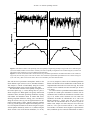
1
Ciencias Marinas (2012), 38(1B): 143–159
Galicia upwelling revisited: out-of-season events in the rias (1967–2009)
C
M
Revisión de los eventos de afloramiento en Galicia: eventos fuera de temporada
en las rías (1967–2009)
I Álvarez1,2, R Prego3*, M deCastro1, M Varela4
1
2
3
4
EPhysLab, Environmental Physics Laboratory, Facultad de Ciencias, Universidad de Vigo, 32004 Orense,
Spain.
CESAM, Departamento de Física, Universidade de Aveiro, 3810-193, Aveiro, Portugal.
Marine Research Institute (CSIC), 36208 Vigo, Spain.
Oceanographic Center of A Coruña (IEO), 15001 A Coruña, Spain.
* Corresponding author. E-mail: [email protected]
ABSTRACT. Over the last decades several studies have been conducted on upwelling along the Galician coast that have significantly improved
the knowledge of this process. These investigations showed that upwelling along this coast is a frequent phenomenon during the spring and
summer months, pumping colder Eastern North Atlantic Central Water into the rias. Nevertheless, several upwelling events in autumn and
winter have been characterized in the Galician rias, indicating that the upwelling process along the Galician coast is not a phenomenon
restricted to spring and summer. In this study the recurrence of these upwelling events has been reviewed from published articles and analyzed
from 1967 to 2009 along the western and northern Galician coasts in terms of an upwelling index. The highest mean number of days under
favorable upwelling conditions per month was observed during spring and summer on the western (18–26 days) and northern (12–14 days)
coasts. During autumn and winter the number of days was lower (11–18 days, western coast; 8–10 days, northern coast) although not
negligible, showing the possibility of observing upwelling events during this period. In fact, during these months a significant probability of
observing favorable upwelling conditions along both coasts (26%) was found, though the most probable situation corresponded to unfavorable
upwelling conditions (44%). The results thus revealed that these events cannot be considered isolated episodes. Upwelling processes in the rias
should be observed under favorable conditions, such as prevalence of northerly wind at the adjacent western Galician shelf, independently of
the season.
Key words: upwelling, autumn, winter, ria, NW Iberian Peninsula.
RESUMEN. Durante las últimas décadas se han llevado a cabo varios estudios relacionados con el fenómeno de afloramiento a lo largo de la
costa de Galicia que han mejorado significativamente el conocimiento de este proceso. De los resultados de estos trabajos se ha encontrado que
el afloramiento a lo largo de esta costa es un fenómeno frecuente durante los meses de primavera y verano, introduciendo Agua Central del
Atlántico Norte en el interior de las rías. Sin embargo, en las rías gallegas se han caracterizado varios eventos de afloramiento durante otoño e
invierno que indican que este proceso no es un fenómeno exclusivo de las estaciones de primavera y verano. En este estudio se hace una
revisión de estos eventos teniendo en cuenta artículos ya publicados y también se analiza su recurrencia a lo largo de las costas oeste y norte de
Galicia a partir de datos de índice de afloramiento de 1967 a 2009. El número medio de días por mes con condiciones favorables de
afloramiento más elevado se observó durante los meses de primavera y verano en la costa oeste (18–26 días) y costa norte (12–14 días).
Durante otoño e invierno este número de días fue menor (11–18 días, costa oeste; 8–10 días, costa norte) aunque no despreciable, indicando la
posibilidad de observar eventos de afloramiento durante este periodo. De hecho, durante estos meses se observó una cierta probabilidad de
obtener condiciones favorables de afloramiento a lo largo de ambas costas (26%), aunque la situación más probable correspondió a condiciones
desfavorables (44%). Estos resultados revelaron que estos eventos no se pueden considerar como episodios aislados. De esto se deduce que los
procesos de afloramiento en las rías deberían ser observados bajo condiciones favorables, tales como vientos predominantes del norte en la
plataforma adyacente, independientemente de la estación.
Palabras clave: afloramiento, otoño, invierno, ría, Península Ibérica.
INTRODUCTION
INTRODUCCIÓN
The Galician coast (NW Iberian Peninsula) is the northernmost limit of the Eastern North Atlantic Upwelling
System, which extends from 10º N to about 44º N (Wooster
et al. 1976). Capes Finisterre and Ortegal mark abrupt
changes in coastline orientation, splitting this region mainly
La costa noroeste de la Península Ibérica es el límite norte
del Sistema de Afloramiento del Atlántico Noreste, el cual se
extiende desde 10º N hasta 44º N (Wooster et al. 1976). Los
cabos Finisterre y Ortegal marcan cambios abruptos en la
orientación de la costa de Galicia, dividiéndola en tres
143
Ciencias Marinas, Vol. 38, No. 1B, 2012
dominios: la costa oeste (al sur de cabo Finisterre), la costa
norte (al este de cabo Ortegal) y la costa intermedia o costa
noroeste comprendida entre ambos cabos (fig. 1). En esa
región geográfica se han llevado a cabo diversos estudios
sobre el afloramiento generado por viento. La primera investigación que analizó en profundidad el proceso de afloramiento fue realizada por Fraga (1981). Este autor describió la
surgencia frente a la costa de Galicia usando mediciones
obtenidas desde 1974 a 1977 en campañas oceanográficas e
hizo hincapié en la las altas concentraciones de nitrato derivadas de dichos eventos dentro de las rías. Anteriormente a
esa labor, destacan dos trabajos científicos relacionados con
el afloramiento que fueron publicados en español y tuvieron
menor difusión. El primer trabajo relacionó la aparición de
agua oceánica fría a lo largo de la costa gallega durante el
verano (julio–agosto) con la llegada de la sardina a la ría de
Vigo (Margalef y Andreu 1958); el otro, atendía a las características termohalinas en la plataforma gallega (Molina 1972).
Desde el artículo publicado por Fraga (1981) la costa
oeste de Galicia ha recibido una atención considerable debido
a la presencia de las Rías Baixas (las rías de la costa oeste de
Galicia). Numerosos estudios han caracterizado diferentes
eventos de afloramiento en la plataforma adyacente a estas
rías (Blanton et al. 1984; Tenore et al. 1984; McClain et al.
1986; Alvarez-Salgado et al. 1993, 2000; Perez et al. 1995;
Prego y Bao 1997; Prego et al. 1999; Barton et al. 2001;
Alvarez et al. 2008a) y también en su interior (Blanton et al.
1987; Prego y Fraga 1992; Prego 1993a, 1993b, 1994; Rosón
et al. 1995; Nogueira et al. 1997a, 1997b; Doval et al. 1998;
Pardo et al. 2001; Prego et al. 1995, 2001; deCastro et al.
2004; Alvarez et al. 2005). Consecuentemente, se puede
resumir que el afloramiento en esta costa occidental gallega
es un fenómeno frecuente durante los meses de primavera y
verano que es resultado del régimen de vientos de componente norte que soplan a lo largo de la plataforma. El
afloramiento introduce en el interior de las rías un agua subsuperficial, más fría y rica en nutrientes que la que desplazan.
La surgencia de Agua Central del Atlántico Noroccidental
(ENACW; Fiuza 1984, Ríos et al. 1992) genera una alta producción primaria que es, en buena parte, responsable de la
elevada pesca y acuicultura que caracteriza a esta región
(Tenore et al. 1995).
Al norte del cabo de Finisterre, también ocurren eventos
de afloramiento durante los meses de primavera y verano,
pero suelen ser discontinuos y se mantienen lejos de la costa,
cerca del borde de la plataforma continental (Prego y Bao
1997, Prego y Varela 1998, Varela et al. 2005). Estas diferentes condiciones de afloramiento a lo largo de la costa de
Galicia se pueden explicar por un cambio de orientación en la
línea de costa que modula la dirección y la intensidad del
viento (Torres et al. 2003, Gómez-Gesteira et al. 2006,
Alvarez et al. 2008b). Como resultado, las condiciones favorables de afloramiento son generalmente más frecuentes
durante los meses estivales al sur del cabo de Finisterre que
a su norte. Además, los patrones de viento en verano e
in three different domains: the western Galician coast (south
of Cape Finisterre), the northern Galician coast (east of
Cape Ortegal) and the middle or northwestern Galician coast
between these two capes (fig. 1). Several studies have been
carried out in terms of wind-driven upwelling in this area.
The first study analyzing the upwelling process in depth was
carried out by Fraga (1981). This author described the
upwelling off the Galician coast using scattered measurements obtained from 1974 to 1977 and emphasized the key
question of the high concentrations of nitrate arising from
upwelling inside the rias. Before this article, two scientific
contributions related to upwelling stand out, although both
were published in Spanish and had little diffusion. The first
one connected the appearance of cold seawater along the
Galician coast in summer (July–August) to the arrival of sardine in the Vigo Ria (Margalef and Andreu 1958). Some
years later, the first study on thermohaline characteristics
along the Galician shelf was published (Molina 1972).
Since Fraga’s (1981) article the western Galician coast
has received considerable attention due to the presence of
four coastal systems known as Rías Baixas (western rias of
Galicia). Numerous studies have characterized different
upwelling events off the western rias, basically at the adjacent shelf (Blanton et al. 1984; Tenore et al. 1984; McClain
et al. 1986; Alvarez-Salgado et al. 1993, 2000; Pérez et al.
1995; Prego and Bao 1997; Prego et al. 1999; Barton et al.
2001; Alvarez et al. 2008a) and also inside the rias (Blanton
et al. 1987; Prego and Fraga 1992; Prego 1993a, 1993b,
1994; Roson et al. 1995; Nogueira et al. 1997a, 1997b; Doval
et al. 1998; Pardo et al. 2001; Prego et al. 1995, 2001;
deCastro et al. 2004; Alvarez et al. 2005). From these studies
it can be summarized that upwelling along this coast is a frequent phenomenon during the spring and summer months
characterized by favorable northerly winds blowing along the
shelf. This upwelling pumps colder nutrient-rich deeper
water known as Eastern North Atlantic Central Water
(ENACW; Fiuza 1984, Ríos et al. 1992) into the rias, generating great primary productivity that can support the high
fishery and aquaculture yields in this region (Tenore et al.
1995).
North of Cape Finisterre, upwelling events also occur
although they are less common than along the western
Galician coast. Some articles have shown that during spring
and summer, upwelling in this area is discontinuous and
remains distant from the coast, near the edge of the continental shelf (Prego and Bao 1997, Prego and Varela 1998, Varela
et al. 2005). These different upwelling conditions along the
Galician coast can be explained by the change in shoreline
orientation that modulates wind direction and intensity
(Torres et al. 2003, Gómez-Gesteira et al. 2006, Alvarez
et al. 2008b). As a result, favorable upwelling conditions are
generally prevalent during the spring and summer months
south of Cape Finisterre but not north of it. In addition, wind
patterns in summer and winter are not necessarily representative of particular years and they may alternate producing
144
Álvarez et al.: Galicia upwelling revisited
invierno se pueden alternar produciendo breves episodios de
afloramiento en la costa norte u oeste, aunque también puede
ocurrir un patrón combinado en ambas costas.
Los estudios citados han mejorado significativamente el
conocimiento del proceso de afloramiento a lo largo de la
costa de Galicia; sin embargo, la idea inicial de un afloramiento estacional (i.e., que se produzca solamente durante la
primavera y el verano) debe ser revisada. De hecho, recientemente se han analizado en las rías gallegas varios eventos de
afloramiento “fuera de estación” desde puntos de vista hidrográficos, biogeoquímicos y planctónicos. Por ejemplo, en la
ría de Pontevedra se ha descrito un evento invernal (enero de
1998) caracterizado por la entrada en la ría de agua cálida y
salina transportada por la corriente ibérica hacia el polo (IPC)
(Alvarez et al. 2003; Prego et al. 2007). También hubo constancia de la presencia de ENACW en dicha ría a finales del
invierno (marzo de 1998, Prego et al. 2007), así como en la
ría de Vigo durante el otoño (noviembre de 2001, deCastro
et al. 2006a) y en el estrecho de Corcubión a mediados del
invierno (febrero de 2005, Varela et al. 2010). Por primera
vez en las rías del Norte de Galicia se describió en febrero de
2008 un afloramiento en invierno (Alvarez et al. 2009), que
se caracterizó por la presencia de agua oceánica subsuperficial procedente de la plataforma continental que no estaba
asociada a ENACW o IPC.
Los referidos eventos de afloramiento en otoño e invierno
a lo largo de la costa de Galicia indican que dicho fenómeno
no se puede considerar limitado a las estaciones de primavera
y verano, esto es, que un afloramiento debe acontecer siempre que las condiciones meteorológicas sean favorables,
independientemente de la época del año. La entrada de distintos tipos de agua dentro de las rías conlleva implicaciones en
los patrones bioquímicos y el fitoplancton. Algunos artículos
ya han destacado el impacto de los afloramientos en invierno
sobre la pesca frente a la costa oeste de la Península Ibérica
(Santos et al. 2004.) y del golfo de Vizcaya (Borja et al.
1996, Koutsikopoulus y Le Cann 1996). El agua transportada
por la IPC aporta a las rías agua más salina y pobre en sales
nutrientes, mientras que la correspondiente al ENACW
ocasiona que el agua de las rías sea más productiva, aunque
durante el invierno en menor medida que en verano (Prego
et al. 2007). Estas circunstancias indican la necesidad de profundizar sobre la aparición de estos fenómenos y determinar
su posible impacto sobre los ecosistemas costeros.
Así, el objetivo de este estudio es caracterizar la recurrencia de los eventos de afloramiento de otoño e invierno a lo
largo de la costa de Galicia. La investigación se plantea con
base en el índice de afloramiento calculado desde 1967 hasta
2009, analizando la frecuencia y la variabilidad del afloramiento. En la siguiente sección se describen los datos y
métodos utilizados en este artículo. La sección de resultados
y discusión está organizada en cuatro subsecciones. En
primer lugar se analizará la variabilidad de las condiciones
de afloramiento en la costa de Galicia durante el periodo
1967–2009 teniendo en cuenta el índice de afloramiento
brief episodes of upwelling on the northern or western coast,
or a combined pattern may occur producing weak upwelling
on both coasts.
All these studies mentioned have significantly improved
the knowledge of the upwelling process along the Galician
coast; nevertheless, the initial idea of one upwelling season
(i.e., upwelling occurring only during spring and summer)
needs to be revised. In fact, several out-of-season upwelling
events have been analyzed in the Galician rias from hydrographical, biogeochemical, and planktonic points of view.
For example, a winter upwelling event (January 1998) was
described in the Pontevedra Ria, characterized by the
entrance into the estuary of warm and salty water driven by
the Iberian Poleward Current (IPC) (Alvarez et al. 2003,
Prego et al. 2007). ENACW was also observed in the
Pontevedra Ria in late winter (March 1998, Prego et al.
2007), in the Vigo Ria during autumn (November 2001,
deCastro et al. 2006a), and in Corcubión Sound in midwinter (February 2005, Varela et al. 2010). Finally, evidence
of winter upwelling was described for the first time in the
northern Galician rias (February 2008, Alvarez et al. 2009),
characterized by the presence of upwelled shelf bottom seawater not associated with ENACW or IPC.
These autumn-winter upwelling events indicate that the
upwelling process along the Galician coast cannot be considered a phenomenon limited to spring and summer and they
should be observed under favorable conditions independently
of the season. In addition, the entrance of these different
water types inside the rias can have implications for biogeochemical and phytoplankton patterns. Some articles have
already emphasized the impact of winter upwelling on fisheries off western Iberia (Santos et al. 2004) and the Bay of
Biscay (Borja et al. 1996, Koutsikopoulus and Le Cann
1996). The IPC can make the water more salty and poor in
nutrient salts, while ENACW can turn the ria more productive, although to a lesser extent than during a summer upwelling event (Prego et al. 2007). These circumstances indicate
that further research is necessary in order to clarify the
occurrence of these phenomena and, consequently, to
determine their possible impact on coastal ecosystems.
Thus, this study aimed to characterize the recurrence of
these autumn-winter upwelling events along the Galician
coast. The research was carried out in terms of an upwelling
index calculated from 1967 to 2009, analyzing upwelling
frequency and variability. In the next section the data and
methods used in this article are described. The results and
discussion section is organized in four subsections. First, the
variability of upwelling conditions will be analyzed along the
Galician coast over the period 1967–2009 considering the
upwelling index calculated from Ekman transport data and
the most representative atmospheric modes in the North
Atlantic region. Second, several autumn-winter upwelling
events characterized over the last years along the western and
northern Galician coasts will be considered to describe
the factors responsible for the occurrence of these events in
145
Ciencias Marinas, Vol. 38, No. 1B, 2012
calculado a partir de los datos del transporte de Ekman y de
los modos atmosféricos más representativos de la región del
Atlántico Norte. En segundo lugar se considerarán varios
eventos de afloramiento de otoño e invierno que han sido
caracterizados en los últimos años a lo largo de la costa oeste
y norte de Galicia para describir los factores responsables de
la ocurrencia de estos eventos en términos de las condiciones
atmosféricas. En tercer lugar se analizará la recurrencia de
los eventos de afloramiento de otoño e invierno durante el
periodo 1967–2009, teniendo en cuenta el número medio de
días por mes con condiciones favorables de afloramiento y
la probabilidad de encontrar días consecutivos bajo estas
condiciones favorables. Esta subsección también incluye un
análisis del índice de afloramiento diario para comparar la
ocurrencia del afloramiento a lo largo de la costa oeste y la
costa norte de Galicia. En cuarto lugar se analizarán las
posibles implicaciones oceanográficas de los eventos de
afloramiento de otoño e invierno conforme sus propiedades
termohalinas. Finalmente, se presenta una última sección que
incluye las conclusiones de este estudio.
terms of atmospheric conditions. Third, the recurrence of
autumn-winter upwelling events will be analyzed over the
period 1967–2009 taking into account the mean number of
days per month under favorable upwelling conditions and the
probability of finding consecutive days under these favorable
conditions. This subsection also includes an analysis of the
daily upwelling index to compare the occurrence of upwelling along the western and northern Galician coast. Fourth,
the possible oceanographic implications of autumn-winter
upwelling events will be analyzed considering the thermohaline properties corresponding to events previously characterized along the Galician coast. Finally, a last section including
the main conclusions of this study is presented.
MATERIAL AND METHODS
In this section the different databases used in this article
are described. An upwelling index (UI) will be calculated
using data from the Pacific Fisheries Environmental Laboratory (PFEL) and from the QuikSCAT satellite. The most representative atmospheric modes in the Northern Hemisphere,
obtained from the Climate Prediction Center (CPC) at the
National Center of Environmental Prediction (NCEP), will
also be considered to analyze upwelling variability. In addition, several cruises carried out along the Galician coast over
the last years will be considered to characterize the thermohaline variables corresponding to different autumn-winter
upwelling events observed inside the estuaries located in the
area.
Ekman transport data provided by PFEL (http://
www.pfeg.noaa.gov) were considered from 1967 to 2009.
The PFEL distributes environmental index products and time
series databases to cooperating researchers, taking advantage
of its long association with the US Navy’s Fleet Numerical
Meteorology and Oceanography Center (FNMOC). The
FNMOC produces operational forecasts of the state of the
atmosphere and the ocean several times daily and maintains
archives of several important parameters. These parameters
are model-derived products that are routinely distributed to
researchers. For our purposes, six-hourly Ekman transport
data were downloaded from PFEL using the Live Access
Server (LAS) at two points selected along the western
Galician coast (42.5º N and 41.5º N along 10.5º W) and two
points selected along the northern one (8.5º W and 7.5º W
along 45.5º N) (fig. 1, crosses) on an approximately 1º × 1º
grid. A control point was also considered at 43.5º N, 10.5º W
(fig. 1, black square). These data sets were averaged to obtain
daily series. The long time resolution of PFEL data allows
analyzing upwelling variability. Thus, the UI was calculated
from Ekman transport data.
Surface wind fields provided by the QuikSCAT satellite
were also considered (http://podaac.jpl.nasa.gov/DATA_
CATALOG/quikscatinfo.html). The data set is available from
1999 to 2009 and consists of global grid values of meridional
and zonal components of wind measured twice daily on
an approximately 0.25º × 0.25º grid with global coverage.
MATERIALES Y MÉTODOS
En esta sección se describen las diferentes bases de datos
utilizadas en este artículo. El índice de afloramiento (IA) se
calculará utilizando los datos obtenidos del Laboratorio
Ambiental de Pesca del Pacífico (PFEL) y del satélite
QuikSCAT. Los modos atmosféricos más representativos
en el hemisferio Norte, obtenidos del Centro de Predicción
Climática (CPC) en el Centro Nacional de Predicción
Ambiental (NCEP), se considerarán para analizar la variabilidad del afloramiento. Además, se tendrán en cuenta varias
campañas oceanográficas realizadas en las costas gallegas
durante los últimos años para caracterizar las variables
termohalinas en diferentes eventos de afloramiento otoñoinviernales en rías.
Los datos del transporte de Ekman obtenidos del PFEL
(http://www.pfeg.noaa.gov) se consideraron desde 1967 hasta
2009. El PFEL distribuye diversos índices medioambientales
y series temporales de diferentes bases de datos para cooperar
con los investigadores, aprovechando su larga asociación con
el Centro Numérico de Meteorología y Oceanografía
(FNMOC) de la Armada de los Estados Unidos. El FNMOC
produce predicciones operativas del estado de la atmósfera y
del océano varias veces al día y mantiene archivos de varios
parámetros importantes. Estos parámetros son productos
derivados de modelos que se distribuyen habitualmente a los
investigadores. Para nuestros propósitos, los datos del transporte de Ekman obtenidos cada seis horas se descargaron
mediante el servidor de acceso directo (LAS) en dos puntos
seleccionados en la costa oeste de Galicia (42.5º N y 41.5º N
en 10.5º W) y dos puntos seleccionados a lo largo de la costa
norte (8.5º W y 7.5º W en 45.5º N; fig. 1, cruces) en una
malla de aproximadamente 1º × 1º. También se consideró un
punto de control a 43.5º N, 10.5º W (fig. 1, cuadrado negro).
Estos conjuntos de datos se promediaron para obtener series
146
Álvarez et al.: Galicia upwelling revisited
diarias. La elevada resolución temporal de los datos de PFEL
permite analizar la variabilidad del afloramiento. Así, el IA
se calculó a partir de los datos del transporte de Ekman.
También se consideraron los campos de viento en
superficie proporcionados por el satélite QuikSCAT (http://
podaac.jpl.nasa.gov / DATA_CATALOG / quikscatinfo.html).
Esta base de datos está disponible desde 1999 hasta 2009
y consiste en valores de las componentes meridional y
zonal del viento medidos dos veces al día en una malla de
aproximadamente 0.25º × 0.25º con cobertura mundial. Los
datos de QuikSCAT se dan en una pasada ascendente y descendente. Los datos correspondientes a una sola pasada presentan numerosas zonas de sombra, por lo tanto, se consideró
un promedio entre ambas pasadas para aumentar la cobertura.
Las medidas de la velocidad del viento varían entre 3 y
20 m s–1 (precisión: 2 m s–1 y 20º en dirección) (consultar el
manual de usuario en ftp://podaac.jpl.nasa.gov/ocean_wind/
quikscat/L3/doc/qscat_L3.pdf). La altura de referencia de los
datos de viento es de 10 m. Es necesario tener en cuenta que
los datos de viento cerca de la costa (<25 km) no están disponibles debido a la existencia de una pequeña máscara causada
por la proximidad de la tierra. Sin embargo, estudios previos
han demostrado que los datos de QuikSCAT son comparables
con los datos modelados en esta área (Gómez-Gesteira et al.
2006, Alvarez et al. 2008b). Se llevó a cabo una comparación
estadística entre las mediciones de viento de satélite y modelos numéricos de alta resolución (Penabad et al. 2008), revelando resultados similares entre los modelos y los datos del
satélite. El transporte de Ekman se calculó utilizando los
datos de viento del satélite (Alvarez et al. 2008b) a lo largo
de toda la costa gallega y en dos puntos de control situados en
42º N, 10º W (costa oeste) y 44.25º N, 8º W (costa norte). La
alta resolución espacial de esta base de datos permite determinar el posible efecto de las características topográficas de
la costa en la variabilidad del viento y, por lo tanto, estos
datos pueden ser usados para caracterizar en detalle las condiciones favorables de afloramiento a lo largo de la costa
oeste y costa norte de Galicia.
El IA se calcula a partir del vector del transporte de
Ekman, Q ≡ (Qx, Qy), como la componente en la dirección
perpendicular a la costa (Bakun 1973, Nykjaer y Van Camp
1994, Gómez-Gesteira et al. 2006). Aunque el ángulo de la
línea costera oeste y norte de Galicia cambia ligeramente del
límite norte al sur y del límite oeste al este, a escala regional
se puede considerar que aproximadamente sigue las líneas de
los meridianos y paralelos. Por lo tanto, –Qx puede considerarse directamente como el IA a lo largo de la costa oeste y
Qy a lo largo de la costa norte. Los valores positivos (negativos) del IA indican condiciones favorables (desfavorables)
de afloramiento.
Los índices de teleconexión más representativos en el
hemisferio Norte (NAO, EA, SCA, EA/WR y POL) se obtuvieron del CPC/NCEP a una escala temporal mensual de
1967 a 2009. La Oscilación del Atlántico Norte (NAO)
consta de un dipolo norte-sur de anomalías de geopotencial
QuikSCAT data are given in an ascending and descending
pass. Data corresponding to one pass present numerous
shadow areas; therefore, an average between both passes was
considered to increase the coverage. Wind speed measurements range from 3 to 20 m s–1 (accuracy: 2 m s–1 and 20º
in direction) (see the user manual at ftp://podaac.jpl.nasa.
gov/ocean_wind/quikscat/L3/doc/qscat_L3.pdf). The reference height of wind data is 10 m. In addition, it is necessary
to take into account that wind data close to the coast
(<25 km) are not available due to the existence of a small
land mask. However, previous studies have shown that QuikSCAT data are comparable to modeled data in this area
(Gómez-Gesteira et al. 2006, Alvarez et al. 2008b). A statistical comparison between satellite wind measurements and
high resolution numerical models was carried out (Penabad
et al. 2008), revealing similar results between models and
satellite data. Ekman transport was calculated using wind
data from the QuikSCAT satellite (Alvarez et al. 2008b)
along the whole Galician coast and at two control points
located at 42º N, 10º W (western coast) and 44.25º N, 8º W
(northern coast). The high spatial resolution of this data set
allows determining the possible effect of coastal topographic
features on wind variability and can be used to characterize
favorable upwelling conditions in detail along the western
and northern Galician coast.
The UI is calculated from the Ekman transport vector,
Q ≡ (Qx, Qy), as the component in the direction perpendicular
to the shoreline (Bakun 1973, Nykjaer and Van Camp 1994,
Gómez-Gesteira et al. 2006). Although the shoreline angle
along the western and northern Galician coast changes
slightly from the northern to the southern limit and from the
western to the eastern limit, at regional scales it may be considered to approximately follow meridian and parallel lines.
Thus, –Qx can be directly considered the UI along the western
coast and Qy along the northern one. Positive (negative) UI
values mean favorable (unfavorable) upwelling conditions.
The most representative teleconnection indices in the
Northern Hemisphere (NAO, EA, SCA, EA/WR, and POL)
were obtained from CPC/NCEP at monthly time scales from
1967 to 2009. The North Atlantic Oscillation (NAO) consists
of a north-south dipole of geopotential anomalies with one
center located over Iceland and the other spanning between
35º N and 40º N in the central North Atlantic. The East
Atlantic (EA) pattern consists of a north-south dipole that
spans the entire North Atlantic Ocean with the centers near
55º N, 20–35º W and 25–35º N, 0–10º W. The anomaly centers of the EA pattern are displaced southeast from the NAO
pattern centers. The Scandinavian (SCA) pattern consists of a
primary circulation center over Scandinavia with a weaker
center of opposite sign over western Europe. The East
Atlantic/West Russia (EA/WR) pattern is one of three prominent teleconnection patterns that affect Eurasia throughout
the year. This pattern consists of four main anomaly centers.
The Europe Polar/Eurasia (POL) pattern consists of one
center over the polar region and centers of opposite sign over
147
Ciencias Marinas, Vol. 38, No. 1B, 2012
con un centro ubicado en Islandia y el otro entre los 35º N y
40º N en el centro del Atlántico Norte. El patrón del Atlántico
Este (EA) consiste en un dipolo norte-sur que se extiende por
todo el océano Atlántico del Norte con los centros cerca de
55º N, 20–35º W y 25–35º N, 0–10º W. Los centros de anomalías del patrón EA están desplazados hacia el sureste con
respecto a los centros del patrón NAO. El patrón Escandinavo (SCA) se compone de un centro de circulación primaria
sobre los países escandinavos, con un centro débil de signo
opuesto sobre Europa occidental. El patrón del Atlántico
Este/Rusia Occidental (EA/WR) es uno de los tres patrones
de teleconexión que afectan a Eurasia a lo largo del año. Este
patrón consta principalmente de cuatro centros de anomalía.
El patrón Europa Polar/Eurasia (POL) se compone de un centro sobre la región polar y centros de signo opuesto sobre
Europa y el nordeste de China. Una descripción detallada de
estos índices de teleconexión se puede encontrar en la página
web de NCEP (http://www.cpc.noaa.gov). La variabilidad del
afloramiento también se analiza en términos de estos modos
atmosféricos.
También se consideraron las variables termohalinas
medidas en 11 campañas oceanográficas realizadas durante el
otoño e invierno entre 1998 y 2008 en las costas oeste y norte
de Galicia. Estas campañas se corresponden con la ocurrencia de varios eventos de afloramiento en otoño-invierno y las
propiedades termohalinas permitirán identificar el agua subsuperficial aflorada en el interior de las rías situadas en la
zona. Los datos de QuikSCAT se utilizaron para calcular el
IA antes y durante los días en los que se realizaron estas
campañas.
Europe and northeastern China. A detailed description
of these teleconnection indices can be found on the
NCEP website (http://www.cpc.noaa.gov). The upwelling
variability will also be analyzed in terms of these atmospheric modes.
Thermohaline variables measured during 11 cruises
conducted in autumn and winter between 1998 and 2008
along the western and northern Galician coasts were also
considered. These cruises correspond to the occurrence of
several autumn-winter upwelling events and their thermohaline properties will allow identifying the different subsurface
seawater upwelled inside the estuaries located in the area.
QUIKSCAT data were used to compute the UI before and
during these cruises.
RESULTS AND DISCUSSION
Variability of upwelling conditions
In this section, the variability of upwelling conditions is
analyzed in terms of the UI calculated from Ekman transport
46°N
RESULTADOS Y DISCUSIÓN
44°N
Cape Ortegal
Variabilidad de las condiciones de afloramiento
Northern
Galician Rias
Cape Finisterre
En esta sección se analiza la variabilidad de las condiciones de afloramiento en términos del IA calculado a partir de
datos del transporte de Ekman y de los modos atmosféricos
más representativos de la región del Atlántico Norte (NAO,
EA, SCA, EA/WR y POL). Este análisis se llevó a cabo de
forma individual para la costa oeste y norte de Galicia
durante el periodo 1967–2009.
En la figura 2a–b se muestra la evolución interanual del
IA promediado espacialmente en los puntos de control (fig. 1,
cruces) durante este periodo de 43 años. Ambas señales
mostraron un comportamiento macroscópico similar con
valores máximos (condiciones favorables de afloramiento) en
primavera y verano y mínimos en otoño e invierno, con
importantes diferencias entre años. Sin embargo, para la
costa oeste (fig. 2a), la señal tiende a estar desplazada hacia
valores positivos, mientras que para la costa norte (fig. 2b)
dicha señal se desplaza hacia valores negativos. La evolución
temporal del IA que se muestra en la figura 2a está de
acuerdo con el patrón obtenido por Alvarez et al. (2008a) a lo
largo de toda la costa occidental de la Península Ibérica
Rias Baixas
42°N
12°W
10°W
8°W
6°W
Figure 1. Map of the Galician coast. The black square and crosses
represent the points where data from the PFEL database were
obtained, and black circles represent the two control points
considered to analyze wind data provided by the QuikSCAT
satellite.
Figura 1. Mapa de la costa de Galicia. El cuadrado negro y las
cruces representan los puntos donde se obtuvieron los datos de la
base de PFEL y los círculos negros representan los dos puntos de
control considerados para analizar los datos de viento
proporcionados por el satélite QuikSCAT.
148
Álvarez et al.: Galicia upwelling revisited
a
500
b
0
-500
-1000
-1500
1970
1975
1980
1985
1990
1995
2000
2005
800
2010
1970
1975
1980
1985
1990
1995
2000
c
2005
2010
d
400
0
-400
-800
-1200
Feb
Apr
Jun
Aug
Oct
Dec
Feb
Apr
Jun
Aug
Oct
Dec
Figure 2. Interannual evolution of the upwelling index (UI) spatially averaged using monthly averages from 1967 to 2009 along the
(a) western and (b) northern coasts of Galicia. Annual cycle of the UI spatially averaged from 1967 to 2009 along the (c) western and
(d) northern coasts of Galicia. The UI was calculated from PFEL data.
Figura 2. Evolución interanual del índice de afloramiento (IA) promediado espacialmente con medias mensuales de 1967 a 2009 a lo
largo de (a) la costa oeste y (b) la costa norte de Galicia. Ciclo anual del IA promediado espacialmente de 1967 a 2009 a lo largo de
(c) la costa oeste y (d) la costa norte de Galicia. El IA se ha calculado a partir de los datos de PFEL.
(37º–43º N), aunque los valores del IA cambian ligeramente
debido a las diferentes áreas consideradas en cada estudio. El
comportamiento observado en la costa norte (fig. 2b) está de
acuerdo con los resultados recientes obtenidos por Alvarez
et al. (2010).
Los valores del IA se promediaron mensualmente durante
el periodo de estudio para determinar la estación con las
condiciones más favorables de afloramiento en ambas costas
(fig. 2c–d). Ambas costas mostraron un ciclo anual con
condiciones favorables de afloramiento en la zona oeste
durante primavera y verano, pero sólo en verano en la
zona norte. El valor máximo del IA se observó en julio en
ambas costas, aunque con valores mayores en la costa oeste
(600 m3 s–1 km–1) que en la norte (200 m3 s–1 km–1). Para el
resto del año, el IA mostró valores negativos o prácticamente
nulos, indicando que los eventos de afloramiento en otoño e
data and the most representative atmospheric modes in the
North Atlantic region (NAO, EA, SCA, EA/WR, and POL).
This analysis is carried out individually along the western
and northern Galician coasts over the period 1967–2009.
The interannual evolution of the spatially averaged UI at
the control points (fig. 1, crosses) during these 43 years is
shown in figure 2a–b. Both signals were grossly similar with
maximum values (favorable upwelling conditions) in spring
and summer and minimum values in autumn and winter,
showing important differences among years. Nevertheless,
along the western coast (fig. 2a) the signal tended to be displaced toward positive values, whereas along the northern
coast (fig. 2b) the signal was displaced toward negative values. The temporal evolution of UI shown in figure 2a agrees
with the pattern obtained by Alvarez et al. (2008a) along the
whole western coast of the Iberian Peninsula (37º–43º N),
149
Ciencias Marinas, Vol. 38, No. 1B, 2012
invierno no son comunes. Sin embargo, en la siguiente
sección se mostrará que estos eventos pueden ocurrir durante
esas estaciones. Las barras de error (desviación estándar de
los datos mensuales) revelan valores despreciables en comparación con la amplitud del ciclo anual calculado en cada
costa. Estos ciclos anuales son congruentes con los resultados
obtenidos por Alvarez et al. (2008a) en la costa atlántica de la
Península Ibérica y por Alvarez et al. (2010) en la cantábrica.
La variabilidad del afloramiento también se puede analizar utilizando los modos atmosféricos más representativos de
la región del Atlántico Norte (NAO, EA, SCA, EA/WR
y POL). Estos modos atmosféricos son a menudo los
fenómenos responsables de los patrones climáticos anormales que ocurren al mismo tiempo sobre grandes distancias
(Rodríguez-Puebla et al. 1998, Lorenzo y Taboada 2005,
deCastro et al. 2006b) y pueden influir en la variabilidad del
afloramiento. Así, se ha calculado el coeficiente de correlación entre dichos patrones e IA para el periodo de afloramiento más favorable y desfavorable en los cuatro puntos de
control (tabla 1). Teniendo en cuenta el patrón observado en
la figura 2c–d, el periodo favorable de afloramiento se consideró desde junio a agosto (JJA) y el periodo desfavorable
entre noviembre y febrero (NDEF).
En la costa oeste de Galicia, el patrón atmosférico más
importante durante NDEF fue EA, que mostró el valor más
alto del coeficiente de correlación (–0.60). Durante JJA el IA
sólo mostró una correlación significativa con el patrón EA/
WR (–0.20). El comportamiento observado durante NDEF
concuerda con las correlaciones entre los patrones atmosféricos y Qx calculadas por deCastro et al. (2008) en el punto
oceánico 43º N, 11º W durante la estación húmeda (NDEF).
La mejor correlación se obtuvo para el patrón EA (0.65).
En la costa norte, el patrón EA demostró ser el modo
atmosférico con mayor influencia en la variabilidad del afloramiento durante ambas estaciones (–0.45). Además, durante
NDEF el patrón EA/WR también mostró cierta influencia en
el IA con una correlación positiva (0.40). No se encontraron
correlaciones significativas para los modos POL y SCA.
Estos resultados también se pueden comparar con los obtenidos por Alvarez et al. (2010) a lo largo de la costa cantábrica.
although the UI values change slightly due to the different
area considered in each study. The behavior observed on the
northern coast (fig. 2b) also agrees with the recent results
obtained by Alvarez et al. (2010).
The UI values were monthly averaged over the period of
study to determine the season with most favorable upwelling
conditions on both coasts (fig. 2c–d). Both coasts showed a
marked annual cycle with favorable upwelling conditions
from spring to summer along the western coast but only in
summer along the northern one. The maximum UI value was
observed in July on both coasts, although the highest values
were close to 600 m3 s–1 km–1 along the western coast and
close to 200 m3 s–1 km–1 along the northern one. For the rest
of the year, the UI presented negative or practically null
values showing that upwelling in autumn and winter was
absent. Nevertheless, in the next section it will be shown that
episodic events can occur during these seasons. Error bars, as
standard deviation of the monthly data, were observed to be
negligible compared to the amplitude of the annual cycle
calculated on each coast. These annual cycles also agree with
the results obtained by Alvarez et al. (2008a) for the whole
western coast of the Iberian Peninsula and by Alvarez et al.
(2010) along the western Cantabrian coast.
The upwelling variability can also be analyzed using the
most representative atmospheric modes in the North Atlantic
region (NAO, EA, SCA, EA/WR, and POL). These atmospheric modes are often the phenomenon responsible for
abnormal weather patterns occurring simultaneously over
vast distances (Rodríguez-Puebla et al. 1998, Lorenzo and
Taboada 2005, deCastro et al. 2006b) and can influence the
upwelling variability. Thus, the correlation coefficient
between these patterns and the UI was calculated for the most
favorable and unfavorable upwelling periods at the four control points (table 1). Taking into account the pattern observed
in figure 2c–d, the favorable upwelling period was considered from June to August (JJA) and the unfavorable period
from November to February (NDJF).
Along the western Galician coast, during NDJF the most
important atmospheric pattern was EA showing the highest
correlation coefficient value (–0.60). During JJA, the UI
Table 1. Correlation coefficient between atmospheric patterns and the upwelling index (UI) calculated during the most upwelling favorable
(June to August, JJA) and unfavorable (November to February, NDJF) periods from 1967 to 2009 at the four control points (significance
level > 95%). The UI was calculated from PFEL data.
Tabla 1. Coeficiente de correlación entre los patrones atmosféricos y el índice de afloramiento (IA) calculado para el periodo más favorable
(de junio a agosto, JJA) y desfavorable (de noviembre a febrero, NDEF) al afloramiento entre 1967 y 2009 en los cuatro puntos de control
(nivel de significancia > 95%). El IA se ha calculado a partir de los datos de PFEL.
Pattern*
42.5º N
JJA
41.5º N
NDJF
JJA
8.5º W
NDJF
JJA
7.5º W
NDJF
JJA
NDJF
NAO
–
0.20
–
0.28
0.32
–0.23
0.33
–0.22
EA
–
–0.62
–
–0.58
–0.43
–0.46
–0.42
–0.44
–0.18
–
–0.22
–
–
–0.39
–
0.41
EA/WR
* NAO, North Atlantic Oscillation; EA, East Atlantic; EA/WR, East Atlantic/West Russia.
150
Álvarez et al.: Galicia upwelling revisited
Estos autores encontraron que durante la estación de invierno
(NDE) los patrones EA/WR y EA explicaban la mayor
variabilidad del IA, mientras que durante el verano (JJA) la
variabilidad se explicaba en términos del patrón EA.
only showed significant correlation with the EA/WR pattern
(–0.20). The behavior observed during NDJF agrees with the
correlations between atmospheric patterns and Qx calculated
by deCastro et al. (2008) at the ocean point 43º N, 11º W also
during the wet season (NDJF). The best correlation was
obtained for the EA pattern (0.65).
Along the northern coast, the EA pattern was the atmospheric mode with most influence on upwelling variability
during both periods (–0.45). In addition, during NDJF the
EA/WR pattern also showed some influence on the UI with a
positive correlation (0.40). No significant correlations were
found for the POL and SCA modes. These results can also be
compared with those obtained by Alvarez et al. (2010) along
the Cantabrian coast of the Iberian Peninsula. They found
that during winter (NDJ), the EA/WR and EA patterns
explained the main variance of UI, while during summer
(JJA) the UI variability was explained in terms of the EA
pattern.
Factores responsables de los eventos de afloramiento de
otoño e invierno
En esta sección se consideran varios eventos de afloramiento caracterizados en otoño e invierno entre 1998 y 2008
en la costa de Galicia para describir los factores responsables
de su ocurrencia. Este análisis se lleva a cabo en términos de
las condiciones atmosféricas.
Como se mencionó anteriormente, el periodo con las condiciones más favorables de afloramiento en Galicia corresponde a primavera y verano. No obstante, en los últimos años
se han caracterizado varios eventos de afloramiento en otoño
e invierno en la costa oeste (Alvarez et al. 2003; deCastro
et al. 2006a, 2008; Prego et al. 2007; Varela et al. 2010) y la
costa norte (Alvarez et al. 2009) de Galicia. El mecanismo
responsable de la aparición de estos eventos es similar al
observado en primavera y verano; es decir, vientos del norte a
lo largo de la costa oeste y vientos del este a lo largo de la
costa norte. En la tabla 2 se muestra un resumen de las condiciones atmosféricas correspondientes a los eventos de afloramiento caracterizados en otoño e invierno. DeCastro et al.
(2008) caracterizaron diferentes casos durante ambas estaciones en la ría de Pontevedra desde 2000 hasta 2005. A modo
de ejemplo, sólo se ha considerado una campaña por año en
la tabla 2.
Los parámetros que se analizaron son la duración de las
condiciones favorables de afloramiento hasta la fecha de cada
una de las campañas y el valor medio del IA durante estos
periodos. Estos parámetros se calcularon mediante los datos
Factors responsible for autumn-winter upwelling events
In this section, several autumn-winter upwelling events
characterized between 1998 and 2008 along the Galician
coast are considered to describe the factors responsible for
their occurrence. This analysis is carried out in terms of
atmospheric conditions.
As previously mentioned, the period of most favorable
upwelling conditions along the Galician coast corresponds
to the spring and summer months. Nevertheless, several
autumn-winter upwelling events have been characterized
over the last years along the western coast (Alvarez et al.
2003; deCastro et al. 2006a, 2008; Prego et al. 2007;
Varela et al. 2010) and along the northern coast (Alvarez
et al. 2009). The mechanism driving these autumn-winter
Table 2. Atmospheric conditions corresponding to the autumn-winter upwelling events characterized along the Galician coast. Duration and
upwelling index (UI) were calculated using wind data provided by PFEL for 1998 and by the QuikSCAT satellite for the rest of the years.
Tabla 2. Condiciones atmosféricas correspondientes a los eventos de afloramiento caracterizados en otoño e invierno a lo largo de la costa de
Galicia. La duración y el índice de afloramiento (UI) se han calculado a partir de los datos de viento proporcionados por el PFEL para 1998 y
por el satélite QuikSCAT para el resto del año.
Geographical zone
Pontevedra Ria
Vigo Ria
Pontevedra Ria
Corcubión Sound
Northern rias
Date of event
Duration
(days)
<UI>
(m3 s–1 km–1)
Reference
7
14
16
17
28
10
19
19
14
31
9
680
800
2080
919
1820
1784
1549
1655
1736
1610
1718
Alvarez et al. (2003)
Prego et al. (2007)
deCastro et al. (2006a)
deCastro et al. (2008)
27 January 1998
24 March 1998
15 November 2001
25 February 2000
27 November 2001
22 February 2002
10 February 2003
16 November 2004
31 January 2005
18 February 2005
20 February 2008
151
Varela et al. (2010)
Alvarez et al. (2009)
Ciencias Marinas, Vol. 38, No. 1B, 2012
upwelling events is similar to the one observed in spring and
summer; namely, northerly winds along the western coast and
easterly winds along the northern coast. A summary of the
atmospheric conditions corresponding to these autumnwinter upwelling events characterized along the Galician
coast is shown in table 2. DeCastro et al. (2008) characterized different autumn-winter upwelling events in Pontevedra
Ria from 2000 to 2005. As an example, only one cruise per
year was considered in table 2.
The analyzed parameters are the duration of favorable
upwelling conditions until the date of each cruise and the
mean UI value during these periods. These parameters were
calculated using wind data provided by the QuikSCAT satellite (fig. 1, black circles), except for the events characterized
in 1998 (Alvarez et al. 2003, Prego et al. 2007). The UI of the
1998 events was calculated using Ekman transport data provided by PFEL for the control point 43.5º N, 10.5º W. Taking
into account this table it is possible to see that most of the
autumn-winter events occurred along the western Galician
coast. The duration of these events ranged from 7 to 31 days
with UI values ranging from 680 to 2080 m3 s–1 km–1. Along
the northern coast only one event was recently characterized
(Alvarez et al. 2009) with a duration of 9 days and a mean UI
value of around 1700 m3 s–1 km–1.
The different autumn-winter upwelling conditions on the
western and northern Galician coasts were also characterized
by means of an example of the atmospheric conditions corresponding to two autumn-winter upwelling events (fig. 3). The
first one corresponds to November 2004 on the western coast
(deCastro et al. 2008) and the second one to February 2008
on the northern coast (Alvarez et al. 2009). Favorable
upwelling conditions were characterized taking into account
the Ekman transport calculated using QuikSCAT wind data
for each coast. In addition, Ekman transport was averaged for
four days before each date. On the western coast (fig. 3a),
Ekman transport was characterized by a northwestward
direction all along the shelf with maximum intensity values
(2800 m3 s–1 km–1) over all the area. On the contrary, on the
northern coast (fig. 3b), the Ekman transport pattern pointed
northward with maximum intensity (2600 m3 s–1 km–1) in the
western area. Taking into account the temporal evolution of
the Ekman transport (table 2), it was found that the cruise on
the western Galician coast was carried out after 19 consecutive days of favorable upwelling conditions, while on the
northern coast the cruise was carried out after 9 consecutive
days of favorable conditions.
de viento proporcionados por el satélite QuikSCAT (fig. 1,
círculos negros), a excepción de los eventos caracterizados
en 1998 (Alvarez et al. 2003, Prego et al. 2007). El IA de los
eventos de 1998 se calculó con los datos del transporte de
Ekman proporcionados por el PFEL en el punto de control
43.5º N, 10.5º W. La mayoría de los eventos de otoño e
invierno se produjeron en la costa oeste de Galicia con una
duración entre 7 y 31 días y valores de IA desde 680
hasta 2080 m3 s–1 km–1. En la costa norte sólo se caracterizó,
recientemente, un evento (Alvarez et al. 2009) que tuvo una
duración de 9 días y un valor medio del IA próximo a
1700 m3 s–1 km–1.
Las condiciones de los eventos de afloramiento en otoño
e invierno en ambas costas de Galicia se caracterizaron por
medio de un ejemplo de las condiciones atmosféricas correspondientes a dos eventos particulares de afloramiento (fig. 3).
El primero corresponde a noviembre de 2004 para la costa
oeste (deCastro et al. 2008) y el segundo a febrero de 2008
para la costa norte (Alvarez et al. 2009). Las condiciones
favorables de afloramiento se caracterizaron teniendo en
cuenta el transporte de Ekman calculado a partir de los datos
de viento proporcionados por el satélite QuikSCAT en cada
costa; además, el transporte de Ekman se promedió durante
los cuatro días anteriores a cada fecha. En la costa oeste
(fig. 3a) el transporte de Ekman mostró una dirección hacia el
noroeste a lo largo de la plataforma con valores máximos de
intensidad (2800 m3 s–1 km–1) en toda la zona. Por el contrario, en la costa norte (fig. 3b) el patrón de transporte fue hacia
el norte con la máxima intensidad (2600 m3 s–1 km–1) en la
zona occidental. Según la evolución temporal del transporte
de Ekman (tabla 2) durante la campaña de la costa oeste, ésta
se realizó después de 19 días consecutivos de condiciones
favorables de afloramiento, mientras que en la costa norte la
campaña se llevó a cabo después de sólo 9 días consecutivos.
Recurrencia de los afloramientos de otoño e invierno
En esta sección se analiza la recurrencia de los eventos de
afloramiento en otoño-invierno para el periodo 1967–2009,
teniendo en cuenta el número medio de días por mes bajo
condiciones favorables de afloramiento y la probabilidad de
encontrar días consecutivos con estas condiciones favorables.
Además, se lleva a cabo una comparación de la ocurrencia de
eventos de afloramiento en las costas oeste y norte de Galicia
según el IA diario.
La frecuencia del afloramiento se puede analizar teniendo
en cuenta el número medio de días por mes bajo condiciones
favorables de afloramiento (IA > 16 m3 s–1 km–1) entre 1967 y
2009 en los puntos de control (fig. 4a). Hay que tener en
cuenta que el umbral elegido corresponde a vientos con
intensidades menores que 1 m s–1 para eliminar las calmas.
En la costa oeste el número de días fue ligeramente superior
en el punto más al sur, mientras que en la costa norte los dos
puntos de control mostraron valores similares. El mayor
número de días con condiciones favorables tuvo lugar en los
Autumn-winter upwelling recurrence
In this section, the recurrence of autumn-winter upwelling events is analyzed over the period 1967–2009 taking into
account the mean number of days per month during favorable
upwelling conditions and the probability of finding consecutive days with these favorable conditions. In addition, a
152
Álvarez et al.: Galicia upwelling revisited
meses de primavera y verano en ambas costas, con valores
más altos en la costa oeste (18–26 días por mes) que en la
norte (12–14 días por mes). Consecuentemente, es posible
corroborar que el periodo más favorable para las condiciones
de afloramiento en Galicia corresponde a primavera y
verano. Sin embargo, durante el otoño y el invierno, el
número de días con condiciones favorables no fue despreciable: 11–18 días por mes al oeste y 8–10 días por mes al norte.
Los resultados obtenidos para la costa oeste se pueden
comparar con la situación observada por Cabanas y Alvarez
(2005) y deCastro et al. (2008), quienes emplearon datos de
transporte de Ekman en el océano (punto 43º N, 11º W)
para un periodo de 40 años (1966–2005). Esos autores reflejaron que el mayor número de días seguidos favorables al
afloramiento ocurrieron en verano, hasta 22–25 días por mes.
Durante el periodo invernal también fue posible observar
un número de días con condiciones favorables en ese punto
(10–12 días por mes). La situación observada en la costa
norte fue parecida a la obtenida por Alvarez et al. (2010) con
dos puntos de control situados en la parte central de la zona
oeste de la costa cantábrica.
La duración del afloramiento también se puede caracterizar por la probabilidad de encontrar días consecutivos con
condiciones favorables de afloramiento durante su periodo
más desfavorable (NDEF, fig. 4b). Las probabilidades encontradas siempre fueron menores en la costa norte. Al oeste la
probabilidad aumentó hacia el sur, mientras que en la costa
norte la variación entre puntos fue prácticamente despreciable. Los valores de probabilidad más altos se observaron
entre 1 y 6 días en ambas costas, con valores que disminuyeron aproximadamente del 50% al 30% al oeste y del 30% al
20% en el norte.
El IA diario también se analizó desde 1967 hasta 2009 en
el punto de control 43.5º N, 10.5º W (fig. 1, cuadrado negro)
para comparar mejor la ocurrencia del afloramiento oestenorte durante el periodo más desfavorable al afloramiento
(NDEF). La figura 5 muestra el IA para las costas oeste (IAO)
y norte (IAN) separado en cuadrantes. El mayor porcentaje de
datos (44%) se observó en la situación correspondiente a condiciones desfavorables para el afloramiento en las dos costas
(cuadrante III), indicando que esta situación era la más
probable. Los valores positivos del IAO y el IAN (cuadrante I)
corresponden a condiciones favorables al afloramiento
en ambas costas, incluyendo al 26% de los datos, que fueron
más favorables en la costa oeste (IAN/IAO = 0.65). El
cuadrante II corresponde a condiciones favorables de afloramiento en la costa norte (IAN positivo) y condiciones desfavorables en la costa oeste (IAO negativo), con probabilidad
baja (11%). El cuadrante IV (IAN negativo, IAO positivo)
corresponde al patrón opuesto al cuadrante II, con una probabilidad similar (19%). Además, el ajuste lineal en ambos
cuadrantes presentó valores de IAN/IAO = –0.34 y IAN/IAO =
–0.60, mostrando que los valores del IA eran más importantes en la costa oeste. Esta situación contrasta con la correspondiente al periodo más favorable al afloramiento (MJJAS)
2800
12-15 November 2004
46°N
2100
44°N
1400
42°N
700
12°W
11°W
10°W
9°W
8°W
7°W
0
16-19 February 2008
2800
45°N
2100
44°N
1400
43°N
700
42°N
0
9°W
8°W
7°W
Figure 3. Ekman transport along the Galician coast calculated
from QuikSCAT data corresponding to the cruises carried out on
(a) 16 November 2004 and (b) 20 February 2008. Data were
averaged for four days before each cruise.
Figura 3. Transporte de Ekman calculado a partir de los datos de
QuikSCAT a lo largo de la costa de Galicia correspondiente a las
campañas llevadas a cabo (a) el 16 de noviembre de 2004 y (b) el
20 de febrero de 2008. Los datos fueron promediados a los cuatro
días anteriores a cada campaña.
comparison of the upwelling occurrence along the western
and northern Galician coasts is carried out considering the
daily UI.
Upwelling prevalence can be analyzed taking into
account the mean number of days per month with favorable
upwelling conditions (UI > 16 m3 s–1 km–1) from 1967 to
2009 at the control points (fig. 4a). Note that the threshold
(16 m3 s–1 km–1) corresponds to winds with intensity less than
1 m s–1 to remove calms. Along the western coast the number
of days was slightly higher at the southernmost point,
while along the northern coast both control points showed
similar values. The highest number of days with favorable
153
Ciencias Marinas, Vol. 38, No. 1B, 2012
30
a
42.5º N
41.5º N
8.5º W
7.5º W
Days
20
10
0
1
2
3
4
5
6
7
8
9
10
11
12
Month
80
b
42.5º N
41.5º N
8.5º W
7.5º W
%
60
40
20
0
1
2
3
4
5
6
7
8
9
10
Days
Figure 4. (a) Number of days per month with upwelling index (UI) values >16 m3 s–1 km–1 averaged from 1967 to 2009 along the
western (42.5º N, 41.5º N) and northern (8.5º W, 7.5º W) coasts of Galicia. (b) Probability of finding consecutive days under favorable
upwelling conditions (UI > 16 m3 s–1 km–1) from 1967 to 2009 during the most unfavorable upwelling period (November to February)
along the western (42.5º N, 41.5º N) and northern (8.5º W, 7.5º W) coasts of Galicia. The UI was calculated from PFEL data.
Figura 4. (a) Número de días por mes con índice de afloramiento (IA) >16 m3 s–1 km–1 promediados de 1967 a 2009 a lo largo de la
costa oeste (42.5º N, 41.5º N) y la costa norte (8.5º W, 7.5º W) de Galicia. (b) Probabilidad de encontrar días consecutivos bajo
condiciones favorables de afloramiento (IA > 16 m3 s–1 km–1) entre 1967 y 2009 durante el periodo más desfavorable de afloramiento
(noviembre a febrero) a lo largo de la costa oeste (42.5º N, 41.5º N ) y la costa norte (8.5º W, 7.5º W) de Galicia. El IA se ha calculado
a partir de los datos de PFEL.
caracterizada por Ospina-Alvarez et al. (2011). Estos autores
encontraron que durante la época típica de afloramiento la
situación más probable correspondía a condiciones favorables de afloramiento a lo largo de ambas costas (44%),
seguida por condiciones desfavorables también en ambas
(29%).
conditions was observed during the spring and summer
months on both coasts, with higher values along the western
coast (18–26 days per month) than along the northern one
(12–14 days per month). Taking into account these results, it
is possible to corroborate that the period for most favorable
upwelling conditions along the Galician coast corresponds to
the spring and summer months. Nevertheless, during autumn
and winter the number of days with favorable conditions was
not negligible with values around 11–18 days per month
along the western coast and around 8–10 days per month
along the northern one. The results obtained along the western coast can be compared with the situation observed by
Cabanas and Alvarez (2005) and deCastro et al. (2008) using
Ekman transport data for the ocean point 43º N, 11º W for a
40-year period (1966–2005). The highest number of days
with favorable upwelling conditions obtained at the ocean
point was also observed during the summer months although
Implicaciones oceanográficas
En esta sección, se analizan las posibles implicaciones
oceanográficas de los eventos de afloramiento en otoño e
invierno teniendo en cuenta las propiedades termohalinas
medidas durante los eventos caracterizados entre 1998 y
2008 en las costas gallegas. En las secciones anteriores, se ha
comprobado que el mecanismo que genera el afloramiento en
otoño e invierno es similar al observado en primavera y
verano; sin embargo, las propiedades termohalinas del agua
154
Álvarez et al.: Galicia upwelling revisited
with higher values (22–25 days per month). During the
winter period it was also possible to observe a number of
days with favorable conditions at this point (10–12 days per
month). The situation observed on the northern coast is also
similar to the one reported by Alvarez et al. (2010) using two
control points located in the central part of the western
Cantabrian coast.
Upwelling duration can also be characterized by the probability of finding consecutive days with upwelling-favorable
conditions during the most unfavorable upwelling period
(NDJF, fig. 4b). Probabilities were always lower along the
northern coast. On the western coast the upwelling probability increased southward, while on the northern coast the variation between points was practically negligible. The highest
probability values were observed between 1 and 6 days on
both coasts, with values decreasing from around 50% to 30%
along the western coast and from 30% to 20% along the
northern one.
The daily UI was also analyzed from 1967 to 2009 at the
control point 43.5º N, 10.5º W (fig. 1, black square) to better
compare upwelling occurrence along the western and northern coasts during the most unfavorable upwelling period
(NDJF). Figure 5 shows the UI calculated for the western
(UIW) and northern (UIN) coasts separated in quadrants. The
highest percentage of data (44%) was observed for the
situation corresponding to unfavorable upwelling conditions
on both coasts (quadrant III), indicating that this situation
was the most probable. Positive values of UIW and UIN
(quadrant I) correspond to favorable upwelling conditions on
both coasts, showing that 26% of data kept these conditions,
which were more favorable on the western coast (UIN/UIW =
0.65). Quadrant II corresponds to favorable upwelling conditions on the northern coast (positive UIN) and unfavorable
upwelling conditions on the western one (negative UIW) with
a low probability (11%). Quadrant IV (negative UIN, positive
UIW) corresponds to the opposite pattern observed in quadrant II with a similar probability (19%). In addition, the linear
fit for both quadrants presented values of UIN/UIW = –0.34
and UIN/UIW = –0.60, showing that the UI values were more
important on the western coast. This situation contrasts with
the one corresponding to the most upwelling-favorable
period (MJJAS) characterized by Ospina-Alvarez et al.
(2011). They found that during the typical upwelling season
the most probable situation corresponded to favorable
upwelling conditions along both coasts (44%), followed
by unfavorable upwelling conditions also along both coasts
(29%).
5000
2500
0
-2500
-5000
-5000
-2500
0
UI w
(m3 s-1
2500
5000
km-1)
Figure 5. Daily upwelling index (UI) calculated from PFEL data
for the western (UIW) and northern (UIN) coasts of Galicia at the
control point 43.5º N, 10.5º W (fig. 1, black square) during the
most upwelling-unfavorable period (November to February) from
1967 to 2009. Data are separated in quadrants, so positive values
of UIW and UIN (quadrant I) correspond to favorable upwelling
conditions on both coasts and negative values (quadrant III)
correspond to unfavorable conditions. Straight lines show the
linear fit for each quadrant. The percentage of total data found in
each quadrant is also shown.
Figura 5. Índice de afloramiento (UI) diario calculado a partir de
los datos de PFEL para la costa oeste (UIW) y la costa norte (UIN)
de Galicia en el punto de control 43.5º N, 10.5º W (fig.1, cuadrado
negro) durante el periodo más desfavorable de afloramiento
(noviembre a febrero) de 1967 a 2009. Los datos están separados
en cuadrantes, por lo que los valores positivos del UIW y UIN
(cuadrante I) corresponden a condiciones favorables de
afloramiento en ambas costas y los valores negativos (cuadrante
III) corresponden a condiciones desfavorables. Las líneas rectas
muestran el ajuste lineal en cada cuadrante. El porcentaje total de
los datos encontrados en cada cuadrante también se muestra.
aflorada pueden ser diferentes. Así, algunos autores han
detectado afloramiento de agua asociada con la IPC (Alvarez
et al. 2003, Prego et al. 2007), con ENACW (deCastro et al.
2006a, 2008; Prego et al. 2007; Varela et al. 2010) y con agua
oceánica subsuperficial procedente de la plataforma (Alvarez
et al. 2009). Para ilustrar estos diferentes tipos de agua subsuperficial, en la figura 6 se muestra el diagrama de temperatura y salinidad correspondiente a los datos medidos durante
las campañas consideradas en la tabla 2. Los datos se obtuvieron de las medidas realizadas cerca del fondo en las estaciones de muestreo localizadas en la boca de cada estuario.
La línea continua representa ENACW definida por Fraga
(1981). El agua aflorada en el interior de la ría de Pontevedra
en enero de 1998 (cuadrado negro) era más salina y más
Oceanographic implications
In this section, the possible oceanographic implications
of autumn-winter upwelling events are analyzed considering
the thermohaline properties measured during the events characterized between 1998 and 2008 along the Galician coast.
In the previous sections, it has been observed that the
155
Ciencias Marinas, Vol. 38, No. 1B, 2012
mechanism driving the autumn-winter upwelling events is
similar to the one observed in spring and summer, though the
thermohaline properties of the upwelled water can be different. Thus, some authors have detected upwelled waters associated with the IPC (Alvarez et al. 2003, Prego et al. 2007),
with ENACW (deCastro et al. 2006a, 2008; Prego et al.
2007; Varela et al. 2010), and with shelf bottom seawater
(Alvarez et al. 2009). To exemplify this different subsurface
seawater, the temperature-salinity diagram corresponding to
sea data measured during the cruises considered in table 2 is
shown in figure 6. Data were obtained from near-bed measurements at the sampling hydrographic stations located at
the mouth of each estuary. The solid line represents ENACW
defined by Fraga (1981). The upwelled water inside the
Pontevedra Ria in January 1998 (black square) was saltier
and warmer than ENACW, corresponding to the water driven
by the IPC. Salinity and temperature measurements corresponding to the cruise carried out in February 2008 in the
northern Galician rias (black triangle) showed that the
upwelled water corresponded to subsurface shelf seawater
not associated with ENACW or IPC. Finally, the rest of the
thermohaline measurements (black circles) indicated the
presence of ENACW inside the estuaries.
Taking into account these results it is possible to observe
that during most of the cruises the upwelled water inside the
rias corresponds to ENACW. On the contrary, IPC was only
observed during one cruise (January 1998) inside the
Pontevedra Ria. This situation contrasts with the conditions
observed in January 2005 also in the same ria, characterized
by the existence of ENACW. The presence of these different
water types at the same time of the year can be explained by
the IPC variability. It is a well-known fact that the IPC usually reaches the Cantabrian Sea at the beginning of every
winter, yet there may be years without IPC influence (Frouin
et al. 1990, García-Soto et al. 2002, Gil 2003). DeCastro
et al. (2011) have recently analyzed the interannual variability of the IPC along the northwestern coast of the Iberian
Peninsula from 1985 to 2006 using the January sea surface
temperature image of each year. These authors found some
years with a strong IPC along the western coast of the Iberian
Peninsula and some years with an inexistent IPC. In fact,
1998 corresponded to a year with a marked IPC turning eastward around Galicia, while 2005 corresponded to a year
without IPC influence. On the other hand, the presence of
upwelled subsurface shelf seawater observed in the northern
Galician rias in February 2008 corresponded to the only winter upwelling event observed until now in this area. Thus, to
clarify why these different water types were found inside the
estuaries, further research should be conducted.
Due to the different thermohaline properties of the
upwelled subsurface seawater, the biogeochemical and phytoplankton patterns inside rias may suffer some changes.
From a circulation viewpoint, the increase in water exchange
between the ria and the ocean due to fluvial forcing, typical
of the wet season, joins the north-wind forcing, typical of the
18
16
27/01/98
14
10/02/03 27/11/01
12
10
35.6
15/11/01
22/02/02
16/11/04
31/01/05 18/02/05
35.7
20/02/08
24/03/98
25/02/00
35.8
35.9
36
Salinity
Figure 6. Temperature-salinity diagram corresponding to sea data
measured during the cruises considered in table 2 at the mouth of
different Galician rias. The solid line represents ENACW as
defined by Fraga (1981).
Figura 6. Diagrama de temperatura y salinidad correspondiente a
los datos medidos durante las campañas consideradas en la tabla 2
en la boca de diferentes rías gallegas. La línea continua representa
ENACW como se define en Fraga (1981).
cálida que ENACW, correspondiendo al agua transportada
por IPC. Los valores de salinidad y temperatura en la
campaña de febrero 2008 en las rías del norte de Galicia
(triángulo negro) indicaron que afloraba un agua subsuperficial desde la plataforma que no era ENACW o IPC. Finalmente, el resto de las medidas de las variables termohalinas
(círculos negros) indicaron la presencia de ENACW dentro
de las rías.
Teniendo en cuenta estos resultados, es posible señalar
que durante la mayor parte de las campañas el agua aflorada
en el interior de las rías corresponde a ENACW. Por el contrario, la IPC sólo se observó en una campaña (enero de
1998) dentro de la ría de Pontevedra. Esta situación contrasta
con las condiciones observadas en enero de 2005 también en
la misma ría, que se caracterizaron por la aparición de
ENACW. La presencia de estos distintos tipos de agua en la
misma época del año se puede explicar por la variabilidad de
la IPC. Es un hecho bien conocido que la IPC alcanza normalmente el mar cantábrico al comienzo de cada invierno;
sin embargo, puede haber años sin influencia de la IPC
(Frouin et al. 1990, García-Soto et al. 2002, Gil 2003).
DeCastro et al. (2011) analizaron recientemente la variabilidad interanual de la IPC a lo largo de la costa noroeste de la
Península Ibérica desde 1985 hasta 2006 usando imágenes de
la temperatura superficial del mar en enero para cada año.
Estos autores encontraron años con una fuerte señal de la IPC
a lo largo de la costa oeste de la Península Ibérica y otros
donde la IPC no se observó. De hecho, 1998 corresponde a
un año con una marcada traza de la IPC que bordea a Galicia,
mientras que 2005 corresponde a un año sin influencia de la
IPC. Por otra parte, el evento de afloramiento de agua subsuperficial, sin ser IPC o ENACW, en el norte de Galicia
156
Álvarez et al.: Galicia upwelling revisited
dry season (Prego and Fraga 1992), and hence the water
residence time inside rias becomes shorter than during
summer upwelling events (Prego et al. 2007). Another consequence is the input of nutrient salts within the rias, which can
vary, according to the type of subsurface seawater, from the
depleted nutrient concentrations associated with the IPC to
the more rich levels corresponding to ENACW. Minor
changes were observed in phytoplankton populations with a
uniform distribution throughout the rias as during unfavorable winter upwelling conditions (Prego et al. 2007). On the
other hand, the entrance of ENACW inside the rias in late
winter can make the coastal zone more productive, contributing to pre-bloom events. Nevertheless, these blooms can be
more the result of increased environmental irradiance favored
by the prevailing winds inducing upwelling than a consequence of nutrient supply (Varela et al. 2010). In all cases the
phytoplankton presented species similar to spring blooms or
to summer upwelling processes (Alvarez et al. 2009, Varela
et al. 2010). To elucidate in detail all of these biogeochemical
and biological processes associated with autumn-winter
upwelling events, more research is advisable.
(febrero de 2008) es el único caso de afloramiento invernal
observado en esa área. Por lo tanto, se deberían llevar a cabo
más investigaciones para aclarar por qué estos distintos tipos
de agua se encontraron dentro de los estuarios.
Debido a las diferentes propiedades termohalinas del
agua subsuperficial aflorada, los patrones biogeoquímicos y
abundancias de fitoplancton dentro de las rías pueden sufrir
algunos cambios. Desde un punto de vista de la circulación,
el aumento del intercambio de agua entre la ría y el océano
debido a un forzamiento fluvial, típico de la estación húmeda,
se suma al forzamiento del viento del norte, típico de la estación seca (Prego y Fraga 1992). Así, el tiempo de residencia
del agua dentro de las rías se hace más corto que durante los
eventos de afloramiento en verano (Prego et al. 2007). Otra
consecuencia es el aporte de sales nutrientes al interior de las
rías, que puede variar, según el tipo de agua aflorada, desde
un agua pobre en nutrientes asociada con la IPC hasta concentraciones altas correspondientes a ENACW. En las poblaciones de fitoplancton se observaron cambios menores con
una distribución uniforme durante el invierno (Prego et al.
2007). Por otro lado, una entrada de ENACW en el interior
de las rías a finales del invierno puede hacer que la zona
costera se vuelva más productiva, contribuyendo a un afloramiento previo de fitoplancton. Sin embargo, estos eventos
pueden ser más el resultado de un aumento de la radiación
ambiental favorecido por los vientos dominantes favorables
al afloramiento que una consecuencia del aporte de nutrientes, ya de por si abundante tras la mezcla invernal (Varela et
al. 2010). En todos los casos el fitoplancton presentó especies
similares a los típicos eventos correspondientes de primavera
o a los procesos de afloramiento de verano (Alvarez et al.
2009, Varela et al. 2010). Se recomienda mayor investigación
para elucidar a detalle todos estos procesos biogeoquímicos
y biológicos asociados con los eventos de afloramiento de
otoño e invierno.
CONCLUSIONS
Taking into account most of the upwelling studies conducted along the Galician coast over the last decades, it is
possible to conclude that upwelling events are a frequent phenomenon during the spring and summer months. In fact, the
analysis of the UI for the period 1967–2009 showed a marked
annual cycle with favorable upwelling conditions in spring
and summer along the western coast but only in summer
along the northern one. The maximum UI value was
observed in July on both coasts. During the winter season, the
EA pattern explained the main variance of the UI on both
coasts, while during summer the UI variability was explained
in terms of the EA pattern along the northern coast and in
terms of the EA/WR pattern along the western coast.
The highest mean number of days with upwellingfavorable conditions per month was observed during the
spring and summer months on both coasts, with higher values
along the western coast than along the northern one. Nevertheless, during autumn and winter the number of upwellingfavorable days was not negligible, showing the possibility of
observing upwelling events during this period. In fact, during
the most unfavorable period (November to February) it was
observed that the most probable situation corresponded to
unfavorable upwelling conditions along both coasts followed
by favorable upwelling conditions also along both coasts.
Thus, autumn-winter upwelling events cannot be considered
isolated episodes, i.e., out of season, and they should be studied under favorable conditions independently of the season.
CONCLUSIONES
La mayoría de los artículos publicados sobre el afloramiento en la costa de Galicia inciden en que los eventos de
afloramiento son un fenómeno frecuente durante los meses
de primavera y verano. A partir del análisis del IA durante el
periodo 1967–2009, se observó un marcado ciclo anual de
condiciones favorables al afloramiento durante la primavera
y el verano para la costa oeste gallega, que se reduce a únicamente el verano para la costa norte. El valor máximo del IA
ocurre en julio para ambas costas. Durante la temporada de
invierno, el patrón EA permite explicar la principal variabilidad del IA en ambas costas, mientras que durante el verano
ha de referirse en términos del patrón EA para la costa norte y
del patrón EA/WR para la costa oeste de Galicia.
El número promedio de días seguidos con condiciones
favorables al afloramiento tiene lugar durante la primavera y
el verano en ambas costas, siendo superior en la costa oeste
que en la norte; no obstante, durante el otoño y el invierno el
número de días favorables al afloramiento permite también la
ACKNOWLEDGEMENTS
This article was partially supported by the Interministerial Commission for Science and Technology (CICYT,
157
Ciencias Marinas, Vol. 38, No. 1B, 2012
Spain, project “Influence of meteorological forcing, land
geochemistry and estuarine zone in the hydrodynamic,
biogeochemical cycle of trace metal and rare earth and
plankton transport in the northern Galician rias (NW Spain)”,
ref. CTM2007-62546-C03/MAR). The first author acknowledges the support by the Ramon y Cajal program. We thank
the kind and useful comments of JL Pelegrí (ICM-CSIC) and
two anonymous reviewers that helped to ameliorate our
manuscript.
posibilidad de observar algunos eventos de afloramiento. De
hecho, en el periodo más desfavorable (noviembre a febrero)
la situación más probable correspondía a condiciones
desfavorables al afloramiento en toda las costas, pero las condiciones favorables al afloramiento no eran nulas. Por ello,
los eventos de afloramiento durante otoño e invierno no se
pueden considerar como episodios aislados, i.e., fuera de
temporada conocida como de afloramiento (primavera y
verano), y deberían ser estudiados bajo condiciones favorables independientemente de la estación.
REFERENCES
AGRADECIMIENTOS
Alvarez I, deCastro M, Prego R, Gómez-Gesteira M. 2003.
Hydrographic characterization of a winter-upwelling event in
the Ria of Pontevedra (NW Spain). Estuar. Coast. Shelf Sci. 56:
869–876.
Alvarez I, deCastro M, Gómez-Gesteira M, Prego R. 2005. Interand intra-annual analysis of the salinity and temperature
evolution in the Galician Rías Baixas-ocean boundary
(northwest Spain). J. Geophys. Res. C, 110, C04008,
doi:10.1029/2004JC002504.
Alvarez I, Gómez-Gesteira M, deCastro M, Dias JM. 2008a. Spatiotemporal evolution of upwelling regime along the western coast
of the Iberian Peninsula. J. Geophys. Res. C, 113, C07020,
doi:10.1029/2008JC004744.
Alvarez I, Gómez-Gesteira M, deCastro M, Novoa EM. 2008b.
Ekman transport along the Galician coast (NW, Spain)
calculated from QuikSCAT winds. J. Mar. Sys. 72: 101–115.
Alvarez I, Ospina-Alvarez N, Pazos Y, deCastro M, Bernardez P,
Campos MJ, Gómez-Gesteira JL, Alvarez-Ossorio MT, Varela
M, Gómez-Gesteira M, Prego R. 2009. A winter upwelling
event in the northern Galician rias: frequency and
oceanographic implications. Est. Coast. Shelf. Sci., 82:
573–582, doi:10.1016/j.ecss.2009.02.023.
Alvarez I, Gómez-Gesteira M, deCastro M, Gómez-Gesteira JL,
Dias JM. 2010. Summer upwelling frequency along the western
Cantabrian coast from 1967 to 2008. J. Mar. Sys. 79: 218–226.
Alvarez-Salgado XA, Rosón G, Pérez FF, Pazos Y. 1993.
Hydrographic variability off the Rias Baixas (NW Spain) during
the upwelling season. J. Geophys. Res. C 98: 14447–14455.
Alvarez-Salgado XA, Gago G, Miguez BM, Gilcoto M, Pérez FF.
2000. Surface waters of the NW Iberian Margin: upwelling on
the shelf versus outwelling of upwelled waters from the Rias
Baixas. Estuar. Coast. Shelf. Sci. 51: 821–837.
Barton ED, Inall ME, Sherwin TJ, Torres R. 2001. Vertical structure,
turbulent mixing and fluxes during Lagrangian observations of
an upwelling filament system off Northwest Iberia. Prog.
Oceanogr. 51: 249–267.
Bakun A. 1973. Coastal upwelling indexes, west coast of North
America, 1946–71. NOAA Tech. Rep. NMF 671, 103 pp.
Blanton JO, Atkinson LP, Castillejo F, Montero AL. 1984. Coastal
upwelling of the Rias Bajas, Galicia, northwest Spain. I.
Hydrographic studies. Rapp. P.V. Reun. Cons. Int. Explor. Mer.
183: 179–190.
Blanton JO, Tenore KR, Castillejo F, Atkinson LP, Schwing FB,
Lavin A. 1987. The relationship of upwelling to mussel
production in the rias on the western coast of Spain. J. Mar. Res.
45: 497–511.
Borja A, Uriarte A, Valencia V, Motos L, Uriarte A. 1996.
Relationships between anchovy (Engraulis encrasicolus L)
recruitment and the environment in the Bay of Biscay. Sci. Mar.
60: 179–192.
Cabanas JM, Alvarez I. 2005. Ekman transport patterns in the area
close to the Galician coast (NW Spain). J. Atmos. Oceanogr.
Sci. 10: 325–341.
Este artículo ha sido parcialmente financiado por la
Comisión Interministerial de Ciencia y Tecnología (CICYT,
España, proyecto “Influence of meteorological forcing, land
geochemistry and estuarine zone in the hydrodynamic, biogeochemical cycle of trace metal and rare earth and plankton
transport in the Northern Galician Rias (NW Spain)”, ref.
CTM2007-62546-C03/MAR). La primera autora agradece el
apoyo proporcionado por el programa Ramon y Cajal.
Damos las gracias a JL Pelegrí (ICM-CSIC) por sus amables
y útiles comentarios al igual que a dos revisores anónimos
que contribuyeron a mejorar nuestro manuscrito.
deCastro M, Gómez-Gesteira M, Alvarez I, Prego. 2004. Negative
estuarine circulation in the Ria of Pontevedra (NW Spain).
Estuar. Coast. Shelf. Sci. 60: 301–312.
deCastro M, Dale AW, Gómez-Gesteira M, Prego RM, Alvarez I.
2006a. Hydrographic and atmospheric analysis of an autumnal
upwelling event in the Ria of Vigo (NW Iberian Peninsula).
Estuar. Coast. Shelf. Sci. 68: 529–537, doi:10.1016/
j.ecss.2006.03.004.
deCastro M, Lorenzo N, Taboada JJ, Sarmiento M, Alvarez I,
Gómez-Gesteira M. 2006b. Teleconnection patterns influence on
precipitation variability and on river flow regimes in the Miño
River basin (NW Iberian Peninsula). Clim. Res. 32: 63– 73.
deCastro M, Gómez-Gesteira M, Alvarez I, Cabanas JM, Prego R.
2008. Characterization of fall-winter upwelling recurrence along
the Galician western coast (NW Spain) from 2000 to 2005:
dependence on atmospheric forcing. J. Mar. Syst. 72: 45–148,
doi:10.1016/j.jmarsys.2007.04.005.
deCastro M, Gomez-Gesteira M, Alvarez I, Crespo AJC. 2011.
Atmospheric modes influence on Iberian Poleward Current
variability. Cont. Shelf Res. 31:425-432.
Doval MD, Nogueira E, Pérez FF. 1998. Spatio-temporal variability
of the thermohaline and biogeochemical properties and
dissolved carbon in a coastal embayment affected by upwelling:
the Ria of Vigo (NW Spain). J. Mar. Syst. 14: 135–150.
Fiuza AFG. 1984. Hidrologia e dinâmica das águas costeiras de
Portugal. PhD thesis, University of Lisbon.
Fraga F. 1981. Upwelling off the Galician coast, northwest Spain. In:
Richardson FA (ed.), Coastal Upwelling. American Geophysical
Union, Washington., pp. 176–182.
Frouin R, Fiuza AFG, Ambar I, Boyd TJ. 1990. Observations of a
poleward surface current off the coasts of Portugal and Spain
during winter. J. Geophys. Res. 95: 679–691.
García-Soto C, Pingree RD, Valdes L. 2002. Navidad development
in the southern Bay of Biscay: climate change and swoddy
158
Álvarez et al.: Galicia upwelling revisited
Prego R, Varela M. 1998. Hydrography of the Artabro Gulf in
summer: western coastal limit of Cantabrian seawater and windinduced upwelling at Prior Cape. Oceanol. Acta 21: 145–155.
Prego R, Bao R, Howland R. 1995. The biogeochemical cycling of
dissolved silicate in a Galician ria. Ophelia 42: 301–318.
Prego R, Barciela C, Varela M. 1999. Nutrient dynamics in the
Galician coastal area (northwestern Iberian Peninsula): do the
Rias Bajas receive more nutrient salts than the Rias Altas? Cont.
Shelf Res. 19: 317–334.
Prego R, deCastro M, Gómez-Gesteira M, Taboada JJ, Montero P,
Pérez-Villar V, Dale A. 2001. Micro-scale hydrography of the
Pontevedra Ria (NW Spain). J. Geophys. Res. C 106(9):
19845–19857.
Prego R, Guzmán-Zuñiga D, Varela M, deCastro M, GómezGesteira M. 2007. Consequences of winter upwelling events on
biogeochemical and phytoplankton patterns in a western
Galician ria (NW Iberian Peninsula). Estuar. Coast. Shelf Sci.
73: 409–422.
Ríos AF, Pérez FF, Alvarez-Salgado XA, Figueiras FG. 1992. Water
masses in the upper and middle North Atlantic Ocean east of the
Azores. Deep-Sea Res. 39: 645–658.
Rodríguez-Puebla C, Encinas AH, Nieto S, Garmendia J. 1998.
Spatial and temporal patterns of annual precipitation variability
over the Iberian Peninsula. Int. J. Climatol. 18: 299–316.
Roson G, Pérez FF, Álvarez-Salgado XA, Figueiras FG. 1995.
Variation of thermohaline and chemical properties in an
estuarine upwelling ecosystem: Ria of Arousa. I. Time
evolution. Estuar. Coast. Shelf Sci. 41: 195–213.
Santos AMP, Peliz A, Dubert J, Oliveira PB, Angelico MM, Re P.
2004. Impact of a winter upwelling event on the distribution and
transport of sardine (Sardina pilchardus) eggs and larvae off
western Iberia: a retention mechanism. Cont. Shelf Res. 24:
149–165.
Tenore KR, Cal RM, Hanson RB, López-Jamar E, Santiago G,
Tietjen JM. 1984. Coastal upwelling off the Rias Bajas, Galicia,
northwest Spain. II. Benthic studies. Rapp. P.V. Reun. Cons. Int.
Explor. Mer. 183, 91–100.
Tenore KR, Alonso-Noval M, Alvarez-Ossorio M, Atkinson LP,
Cabanas JM, Cal RM, Campos HJ, Castillejo F, Chesney EJ,
Gonzalez N, Hanson RB, McClain CR, Miranda A, Roman MR,
Sanchez J, Santiago G, Valdes L, Varela M, Yoder J. 1995.
Fisheries and oceanography off Galicia, NW Spain: Mesoscale
spatial and temporal changes in physical processes and resultant
patterns of biological productivity. J. Geophys. Res. 100:1094310966.
Torres R, Barton ED, Miller P, Fanjul E. 2003. Spatial patterns of
wind and sea surface temperature in the Galician upwelling
region. J. Geophys. Res. 108: 3130–3143, doi:10.1029/
2002JC001361.
Varela M, Prego R, Pazos Y, Moroño A. 2005. Influence of
upwelling and river runoff interaction on phytoplankton
assemblages in a middle Galician ria and comparison with
northern and southern rias (NW Iberian Peninsula). Estuar.
Coast. Shelf Sci. 64: 721–737.
Varela M, Alvarez-Ossorio M, Bode A, Prego R, Bernardez P,
García-Soto C. 2010. The effects of a winter upwelling on
biogeochemical and planktonic components in an area close to
the Galician upwelling core: the Sound of Corcubion (NW
Spain). J. Sea Res. 64:260-272.
Wooster WS, Bakun A, McClain DR. 1976. The seasonal upwelling
cycle along the eastern boundary of the North Atlantic. J. Mar.
Res. 34: 131–141.
structure from remote sensing and in situ measurements. J.
Geophys. Res. 107, C8, doi:10.1029/2001JC001012.
Gil J. 2003. Changes in the pattern of water masses resulting from a
poleward slope current in the Cantabrian Sea (Bay of Biscay).
Estuar. Coast. Shelf. Sci. 57: 1139–1149.
Gómez-Gesteira M, Moreira C, Alvarez I, deCastro M. 2006.
Ekman transport along the Galician coast (NW Spain)
calculated from forecasted winds. J. Geophys. Res. C, 111,
C10005, doi: 10.1029/2005JC003331.
Koutsikopoulos C, Le Cann B. 1996. Physical processes and
hydrological structures related to the Bay of Biscay anchovy.
Sci. Mar. 2: 9–19.
Lorenzo MN, Taboada JJ. 2005. Influences of atmospheric
variability on freshwater input in Galician rias in winter. J.
Atmos. Ocean Sci. 10: 377–387.
Margalef R, Andreu B. 1958. Componente vertical de los
movimientos del agua en la ría de Vigo y su posible relación con
la entrada de sardina. Invest. Pesq. 11:105–126.
McClain CR, Chao S, Atkinson LP, Blanton JO, Castillejo F. 1986.
Wind driven upwelling in the vicinity of Cape Finisterre, Spain.
J. Geophys. Res. C 91: 8470– 8486.
Molina R. 1972. Contribución al estudio del “upwelling” frente a la
costa noroccidental de la Península Ibérica. Bol. Inst. Esp.
Oceanogr. 152: 1–39.
Nogueira E, Pérez FF, Ríos AF. 1997a. Seasonal patterns and longterm trends in an estuarine upwelling ecosystem (Ria of Vigo,
Spain). Estuar. Coast. Shelf. Sci. 44: 285–300.
Nogueira E, Pérez FF, Ríos AF. 1997b. Modelling thermohaline
properties in an estuarine upwelling ecosystem (Ría de Vigo:
NW Spain) using box-Jenkins transfer function models. Estuar.
Coast. Shelf. Sci. 44: 685–702.
Nykjaer L, Van Camp L. 1994. Seasonal and interannual variability
of coastal upwelling along northwest Africa and Portugal from
1981 to 1991. J. Geophys. Res. C 99(7): 14197–14207.
Ospina-Alvarez N, Prego R, Alvarez I, deCastro M, AlvarezOssorio MT, Pazos Y, Campos MJ, Bernardez P, García-Soto C,
Gómez-Gesteira M, Varela M. 2011. Oceanographical patterns
during a summer upwelling-downwelling event in the northern
Galician rias: comparison with the whole ria system (NW
Iberian Peninsula). Cont. Shelf. Res. 30: 1362-1372.
Pardo PC, Gilcoto M, Pérez FF. 2001. Short-time scale coupling
between thermohaline and meteorological forcing in the Ria de
Pontevedra. Sci. Mar. 65: 229–240.
Penabad E, Alvarez I, Balseiro CF, deCastro M, Gómez B, PérezMuñuzuri V, Gómez-Gesteira M. 2008. Comparative analysis
between operational weather prediction models and QuikSCAT
wind data near the Galician coast. J. Mar. Syst. 72: 256–270.
Pérez FF, Ríos AF, King BA, Pollard RT. 1995. Decadal changes of
the θ-S relationship of the Eastern North Atlantic Central Water.
Deep-Sea Res. 42: 1849–1864.
Prego R. 1993a. Biogeochemical pathways of phosphate in a
Galician ria (northwestern Iberian Peninsula). Estuar. Coast.
Shelf Sci. 37: 437–451.
Prego R. 1993b. General aspects of carbon biogeochemistry in the
ria of Vigo (NW Spain). Geochim. Cosmochim. Acta 57:
2041–2052.
Prego R. 1994. Nitrogen interchanges generated by biogeochemical
processes in a Galician ria. Mar. Chem. 45: 167–176.
Prego R, Fraga F. 1992. A simple model to calculate the residual
flows in a Spanish ria. Hydrographic consequences in the ria of
Vigo. Estuar. Coast. Shelf Sci. 34: 603–615.
Prego R, Bao R. 1997. Upwelling influence on the Galician coast:
silicate in shelf water and underlying surface sediments. Cont.
Shelf Res. 17: 307–318.
Received May 2010,
received in revised form November 2010,
accepted January 2011.
159