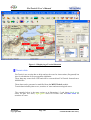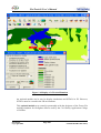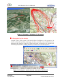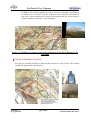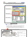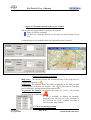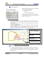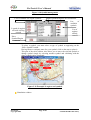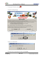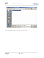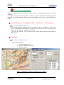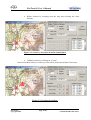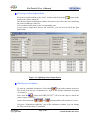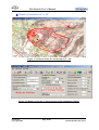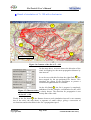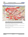
1
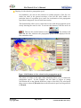
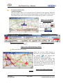
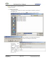
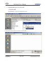
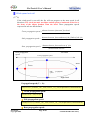
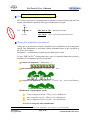
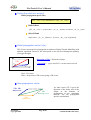
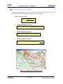
FireTactic® User’s Manual FireTactic® User’s Manual Version 7.9 Forest fire fighting decision-making assistance tool FireTactic® - evolving to provide you with mission assistance ® FireTactic Page 0/56 Centre d’Essais et de Recherche de l’Entente Copyright 2006, Sécurité Civile Valabre 13120 Gardanne Tel +33 4 42 60 86 85 INTERGRAPH Public Safety France SA INTERGRAPH Public Safety Espace Cézanne - 14 Parc Club du Golf BP 137000 13793 Aix en Provence Tel +33 4 42 16 35 87 FireTactic® User’s Manual FIRETACTIC®– Mobile PC Forest Fire Simulation version Product reference: IPSFR021 The FIRETACTIC Forest Fire simulation software has been developed by Intergraph Public Safety France to help Firefighters optimise their battle against forest fires through a quick, simple and effective modelling tool. Using conventional meteorological data (wind speed and direction, temperature, sunlight and water supply), the operator will almost instantly have information on how the fire will spread over the following hours. Quick In this fight against the clock, just a few seconds are enough to model the fire’s progress over several hours and thus optimise the operational response out in the field. Complete So as to be even more accurate, the operator can model dynamic fire barriers symbolising how resources intervene out in the field, the nature of the vegetation or even non-flammable zones. The operator can also draw a fire front line from which simulation will start and can also position vehicles directly on the map to reflect the operational situation as best as possible. Simple This mobile version of the simulator can be installed extremely easily on a standard or portable computer (Windows NT/2000 Pro) and can thus be readily deployed in COZ and CODIS but also directly out in the field on mobile PCs, training rooms and forecasting departments. FIRETACTIC uses a standard map background (1/25000 for example) and provides an optimum response with Digital Terrain Modelling (meshing giving the altitude). FIRETACTIC is extremely easy to use and does not require any special training, on-line help being quite adequate. The simulator has been in operational use since 1998 by the Firefighters of the Bouches du Rhône, since 2004 in the Pyrénées Orientales and has been certified on many major outbreaks of fire over the last 20 years. FireTactic® Copyright 2006, Page 1/56 INTERGRAPH Public Safety FireTactic® User’s Manual Contents Quick .............................................................................................................................1 Complete .......................................................................................................................1 Simple............................................................................................................................1 Contents.....................................................................................................................................2 Forest fire missions with help from FireTactic® ............................................................5 Study of the zone for intervention ..............................................................................5 SITAC function: Tactical Situation ...........................................................................6 • Symbology and graphics............................................................................................6 • Terrain data ................................................................................................................7 A Navigator for the terrain .............................................................................................9 Terrain Information Function ......................................................................................10 Resources and Information Functions .........................................................................11 Resources Function..................................................................................................11 Information Function ...............................................................................................12 Transmission of information in the chain of command .............................................12 Forecast Function: Simulation of propagation helps anticipate................................13 FIRETACTIC®: Presentation ....................................................................................15 Data .............................................................................................................................15 Statistical data ..........................................................................................................15 Relief (Digital Terrain Modelling).......................................................................15 Permanent fire barriers.........................................................................................15 Vegetation ............................................................................................................16 Meteorological zones ...........................................................................................16 Dynamic data ...........................................................................................................16 Meteorological data .............................................................................................16 Area vegetation ....................................................................................................16 Graphs ..................................................................................................................17 Map tool ......................................................................................................................17 FIRETACTIC® windows...........................................................................................17 The framework window...........................................................................................19 Main windows..........................................................................................................19 Tools window.......................................................................................................19 Simulation window ..............................................................................................23 Additional windows .................................................................................................26 The Meteorological Information window............................................................27 The relief display window ...................................................................................28 FireTactic® Copyright 2006, Page 2/56 INTERGRAPH Public Safety FireTactic® User’s Manual Display of risks related to propagation speed ......................................................29 Helicopter path functionality ...............................................................................30 Save and send data by email functionality...........................................................31 Step-by-step simulation ...............................................................................................35 Fire at Gémenos - 21 August 1990 – 17.30 hours - 768 hectares .........................35 Circumstances of the fire .........................................................................................35 Simulation...................................................................................................................35 Location of the incident ...........................................................................................35 Entering meteorological data ...................................................................................37 Starting up simulation ..............................................................................................37 Result of simulation at T+ 60 ..................................................................................38 Result of simulation at T+ 120 with a fire barrier ...................................................39 Positioning symbols on the map ..............................................................................40 Propagation of forest fires.............................................................................................41 Fire triangle ................................................................................................................41 Propagation mechanisms...........................................................................................42 Flammability of plant species ......................................................................................42 The water reserve in the ground...............................................................................43 Natural propagation factors......................................................................................44 Speed of combustion: vegetation + sunlight + temperature ................................44 Taing the wind into account (basic propagation speed)...........................................44 Taking the relief into account ..................................................................................44 Modelling forest fires in ellipses.................................................................................45 Presentation of the elliptical model ..........................................................................45 Wind speed null (V=0) ............................................................................................45 Wind speed not null .................................................................................................46 Creating the wind propagation vector (Vpv) ...........................................................47 Taking the vegetation into account ..........................................................................47 Taking the relief int account ....................................................................................48 Relief propagation vector (Vpr) ...............................................................................48 New propagation vector:..........................................................................................48 Final parameters of the ellipse .................................................................................49 Association of ellipses ................................................................................................50 Taking data from utside the original algorithm into account................................50 Dynamic and permanent fire barriers ......................................................................50 Example of permanent fire barriers ....................................................................51 Example of a dynamic fire barrier .......................................................................51 Drawing of a fire front .............................................................................................52 Drawing of a spot meteorological zone ...................................................................52 Summary of fire propagation speed calculations ......................................................53 FireTactic® Copyright 2006, Page 3/56 INTERGRAPH Public Safety FireTactic® User’s Manual Table of illustrations ...............................................................................................................54 APPENDIX: ............................................................................................................................56 Case study................................................................................................................................56 FireTactic® Copyright 2006, Page 4/56 INTERGRAPH Public Safety FireTactic® User’s Manual Forest fire missions with help from FireTactic® Since 1995, INTERGRAPH Public Safety has been working with the Departmental Fire and Emergency Services (Service Départemental d’Incendie et de Secours) of the Bouches du Rhône and the Entente Test and Research Centre (Centre d’Essai et de Recherche de l’Entente) to develop tools for all players in the ICSD. Every year, new functionalities allow for enhanced control over information and thus the ensuing action. FireTactic® is a reliable product that is simple to use and open-ended, developed in constant partnership with firefighters to integrate all the functionalities needed for optimum management of forest fires. CEREN uses it for feedback and periodically refines it to improve accuracy in calculating propagation and thus public safety (those intervening and the population). Study of the zone for intervention The Firetactic® mapping tool allows you to display vector IGN (Ordnance Survey) raster and orthophoto data in 2D or 3D 3D display requires the use of an additional module Figure 1-1- Various map windows including 2 in 3D display The integrated map tool allows you to attach background map files and aerial photos on a vectorial base capable of containing data like ICSD. A cross-section and a 3D display tool allow you to accurately analyse the Intervention Zone. FireTactic® Copyright 2006, Page 5/56 INTERGRAPH Public Safety FireTactic® User’s Manual Figure 1-2-Display of a terrain cross-section SITAC function: Tactical Situation The graphical symbolism is available and can readily have its parameters set so as to plot the operational situation, while tables on resources and information on the SITAC computer or on a remote computer allows for complete control over the intervention. Symbology and graphics You can use FireTactic® to create and display graphs to represent fire fronts, fire barriers, etc. You can also use FireTactic® to place symbols for fire engines and symbols for situations to display the tactical situation and have it evolve. Movement of fire engines can be achieved manually or automatically if the engine monitoring option is available and activated. FireTactic® Copyright 2006, Page 6/56 INTERGRAPH Public Safety FireTactic® User’s Manual Figure 1-3-Displaying a Tactical Situation Terrain data FireTactic® uses terrain data to help analyse the zone for intervention (fireground) but also for calculation of fire propagation simulation. These data may come from a GIS and will be converted into FireTactic® format from a Mif/Mid file. These data can be generated or modified from the MFFSTools® module. Terrain data includes plant cover, stretches of water and meteorological zones. The example below is the same region as in illustration 1-3 and shows dark green zones for pine tree areas, light green zones for kermes oaks and blue zones for stretches of water. FireTactic® Copyright 2006, Page 7/56 INTERGRAPH Public Safety FireTactic® User’s Manual Figure 1-4-Display of a Tactical Situation An optional module can be used to display simulations and SITACs in 3D. However, SITACs must be created in the 2D environment. This optional module was created in partnership with the designers of the Forest Fire training simulator for firefighter officers used by the Civil Safety Application College of Valabre. FireTactic® Copyright 2006, Page 8/56 INTERGRAPH Public Safety FireTactic® User’s Manual Figure 1-5-Example of 3D display of a 2D contour A Navigator for the terrain Coupled with a GPS system, FireTactic® allows firefighters on the ground or in aircraft to find their position on the map and thus assess the extent of the disaster by measuring the contours of the fire. When used from a helicopter, the operator can obtain his path (distance, heading and time) in relation to a selected objective. Figure 1-6-Navigator’s window directly connected to FireTactic® FireTactic® Copyright 2006, Page 9/56 INTERGRAPH Public Safety FireTactic® User’s Manual In addition, the same navigation tool can be used (in a helicopter, for example) to outline a fire’s contours. The fire contour is drawn directly in FireTactic® and can be used to analyse the extent of the disaster and also if necessary be used as an initial contour for a new simulation. Figure 1-7-Example of a contour made from a helicopter on the fire at Ensues(13) on 11/07/2003 Terrain Information Function You can use a module on PDA to mark out the contours of a fire on foot. The contour can then be imported into FireTactic®. FireTactic® Copyright 2006, Page 10/56 INTERGRAPH Public Safety FireTactic® User’s Manual Figure 1-7- The orange line shows a contour with a PDA at Ventabren (13) on 09/09/2004 Resources and Information Functions FireTactic® offers two complementary modules to assist resource and information officers. The two tables below are interconnected with FireTactic®. They can be used on the same computer or on remote computers. (See next paragraph). Resources Function You can use the resources table to manage resources in transit and on site. An icon can be associated with each type of engine. You can also create a group of engines for greater clarity. This functionality has been added to integrate Operational and Command Management techniques. Figure 1-8-Table of resources FireTactic® Copyright 2006, Page 11/56 INTERGRAPH Public Safety FireTactic® User’s Manual Information Function The message table contains all correspondence on a forest fire exchanged between the various interlocutors. This table is the logbook for the intervention. This functionality has been added to integrate Operational and Command Management techniques. Figure 1-9-Table of messages Transmission of information in the chain of command FireTactic® Copyright 2006, Page 12/56 INTERGRAPH Public Safety FireTactic® User’s Manual To enhance transmission of FireTactic® operational information, dynamic data can be forwarded directly by sending an e-mail to a pre-defined series of addresses through the GPRS. The recipient can thus have exactly the same operational information as the sender. All data entered are stored cyclically and can be exported in Excel type files for future use. Similarly, you can set FireTactic® parameters to define the automatic archiving cycle. Figure 1-10-Possible diagram of the FireTactic® system in a network Forecast Function: simulation of propagation helps anticipate You can use modelling to evaluate how a forest fire spreads as from when you identify the point where it started, and then go on tointegrate the relief, vegetation, urbanisation and above all the meteorological conditions. It is rapid enough to display a simulation of several hours of free propagation or integrating the effect of firefighting engines within a few seconds. Using simple vegetation, relief and meteorological data, the system calculates 2 or 3 hours of propagation or more within a few seconds. This calculation algorithm was set up in partnership with Pr JC Drouet, the University of Provence, the Centre d’Essais et de Recherche de l’Entente and Intergraph. FireTactic® Copyright 2006, Page 13/56 INTERGRAPH Public Safety FireTactic® User’s Manual Figure 1-10-Possible diagram of the FireTactic® system in a network In this example, the fire has taken two hours to cover the green contour. The red contours give a simulation every 10 minutes. FireTactic® provides a correct picture for the fire head and the fire front. The work of the personnel on the ground and aircraft is visible on the rear right part, meaning its spread in that direction is being prevented. The simulation allowed the fact that propagation was going to follow two axes, that of the wind that is easy to predict but also that of the relief that is less clearly visible on the map but much more destructive in the present instance, to be highlighted. Since 2002, the CEREN scientific team has tested and used FIRETACTIC® to validate its propagation module and navigation and SITAC functionalities. During some major fires in 2003, 2004 and 2005, it provided precious information in real time to the site Command Stations and the Zone Operations Centre on propagation and estimations of the surface areas affected and threatened so as to allow for improved decision-making. For the algorithm part, INTERGRAPH, CEREN and the University of Provence are continuing their research work to improve modelling. With 4 years of feedback, the team has a large number of case studies available to it that can be provided on request. FireTactic® Copyright 2006, Page 14/56 INTERGRAPH Public Safety FireTactic® User’s Manual FIRETACTIC®: Presentation Data FIRETACTIC needs a certain number of data to perform calculation of fire propagation. Some of these data are statistical data, while others are dynamic data. Statistical data Relief (Digital Terrain Modelling) You can use this file to find the altitude of any point in the operational zone. These data are archived in the form of a matrix in a file. The matrix has an X “increment” (distance between two lines and two columns: e.g. 50 metres). Without this file or where there is too big an “increment”, the relief will not be taken into account by the simulator. It is necessary for this “increment” to be at least twice as small as the distance covered during a simulation increment. This file must be created once only Y for any new operational zone. For each of the following types of data, a “.ply” file is created. These files enclose a series of numbered polygons. They are generated and updated using the CADTOOLS® program from INTERGRAPH. However, the use of off-the-shelf GIS standards generally allows for transfer of such data. Permanent fire barriers Permanent fire barriers represent non-flammable zones: a fire cannot propagate in these zones that repesent stretches of water or waterways, or zones devoid of any vegetation…. Each zone, materialised as a polygon, must be created in the “permanent fire barriers” file. FireTactic® Copyright 2006, Page 15/56 INTERGRAPH Public Safety FireTactic® User’s Manual Vegetation As for non-flammable zones, vegetation is defined by polygons with which vegetation dominants are associated. FIRETACTIC® has taken as a predicate that any zone not defined in the vegetation file or in the “permanent fire barriers” file is considered to be a zone with kermes oak type vegetation. The choice of this type by default lies in the fact that this type of vegetation is the one that gives the highest propagation speed. When making forecasts, it is always best to foresee the worst case. The vegetation file is important for optimum simulation but is not indispensable. To date, FIRETACTIC® distinguishes 3 types of dominants: kermes oak, pines and green oaks. Others are planned for by configuration. Meteorological zones The operational zone can be divided into several meteorological zones. This concerns parts of the operational zone with the same climatological characteristics: wind speed and direction, temperature, water reserves and sunlight. These zones, represented by polygons, are also defined in a “.ply” file. The 5 meteorological parameters (wind direction and speed, sunlight, temperature and water reserves), assigned independently to each of these zones, are dynamic data the operator enters into FIRETACTIC®. Dynamic data Meteorological data You can use a FIRETACTIC® window to fill in the 5 parameters of each of the meteorological zones defined in the “meteo” file. To optimise simulation, a spot meteorological zone can be created. The operator can draw it with a few clicks directly on the FIRETACTIC® map. This can be the consequence of a valley floor, a hill, the line of a ridge, etc. You can also assign spot meteorological data to the entire fire. Area vegetation During simulation, the operator can assign a dominant for vegetation to the entire fire. In this case, FIRETACTIC® will not seek the data contained in the vegetation file. This process can be used to remedy a possible lack of information in the vegetation file. For example, information on the vegetation dominant can come directly from the COS (Emergency Operations Commander) environment description message he will send when arriving on field. FireTactic® Copyright 2006, Page 16/56 INTERGRAPH Public Safety FireTactic® User’s Manual Graphs FIRETACTIC® proposes graphic commands that allow you to draw polygons in the map window extremely easily. A meaning is assigned to each. These graphs are dynamic parameters allowing simulation to be improved. Three types of graphs can be drawn for each fire: Dynamic fire barriers that can symbolise the action of forces out in the field, a break or an interface in the vegetation … A fire front used by FIRETACTIC® as an initial contour for the following simulation. This means you can answer the problem “Knowing that the fire currently has this given contour, what will its contour be in X minutes?” A spot meteorological zone when meteorological data on the fire zone are known precisely and are more detailed than those for the standard zone. Map tool FIRETACTIC® uses the INTERGRAPH Public Safety map tool. FIRETACTIC® is based on the map tool. It allows for location and rapid creation of incidents, display of the fire contours and placement of symbols (for vehicles, AVE, HBE, etc.). In addition, the tool offers the possibility of assigning a vector file of “image” files: IGN type maps, aerial photos, etc. According to the level of zoom, you can display different data. For example, a zoom between 10 and 75 km on the IGN 1/100 000 maps and between 0 and 10 km for maps to scale 1/25000. Adding these files is essential for correct display of fire contours. Map with vectorial data only Map with vectorial data + IGN 1 /25000 raster Map with vectorial data + Orthoplan Photo Figure 2-1-Example of three possible types of map display Prior formatting of “image” files is needed for FIRETACTIC® to use them. The map tool also allows you to display permanent data defined in vegetation, meteorological and fire barrier files. FIRETACTIC® windows FIRETACTIC® has three categories of windows: FireTactic® Copyright 2006, Page 17/56 INTERGRAPH Public Safety FireTactic® User’s Manual A framework window to make the link between all windows Main windows bringing together information themes A “map” window A “simulation” window A “tools” window allowing for the creation and update of incidents, graph management, adding symbols, etc. Additional windows and dialogues for simulation: meteorological data management, print and recording manager, static data display, etc. Additional functionality windows: display of relief, GPS functionalities, helicopter navigation, data transmission, etc. Figure 2-2-The FIRETACTIC® framework window and 3 main windows FireTactic® Copyright 2006, Page 18/56 INTERGRAPH Public Safety FireTactic® User’s Manual The framework window The framework window makes the link between the main windows. You can use this window’s menu bar to access the main windows, certain additional windows and simulation base commands. Distance and azimuth measurement 1 Activation of the tools Helicopter path fu window Activation of the Simulation 1 window Erases all simulations Display of relief Data export function Helicopter path function GPS monitoring Slide the map Terrain data display Window Meteorological Help window Recording window Print window Map window management Direct commands for simulation • Zoom in • Zoom out • Reset the map on the operational zone • Zoom onto the rectangle selected on the map • Refresh display • Select display mode • Activation of Meteorological data window • New simulation • Fire at T+10 minutes • Fire at T+1 hour • Fire at T+2 hours • Zoom onto fire (display of entire Figure 2-3-Functionalities of the framework window menu bar 1: Main windows Main windows Tools window FireTactic® Copyright 2006, Page 19/56 INTERGRAPH Public Safety FireTactic® User’s Manual You can use this window to generate and update incidents, place symbols and, finally, draw graphs for fire fronts, fire barriers and spot meteorological zones. Incident management Graph management Symbol management Figure 2-4-The tools window Incident management To perform a simulation, an incident must first be generated. Where no fire front exists, its location is considered to be the point of outbreak of the fire. Precise location of this point of outbreak is thus extremely important. The incident will be materialised in the map tool by a small numbered flag: . Incident numbers are incremented automatically. Incident co-ordinates and altitude Number of selected incident Activation of the command to select an incident on the map. FireTactic® Page 20/56 Copyright 2006, Incident ICSD co-ordinates Command to re-locate the selected incident. INTERGRAPH Public Safety Command to erase the selected incident. FireTactic® User’s Manual Figure 2-5-Incident selected in the “tools” window The operator has two methods to generate an incident: Entry of ICSD co-ordinates. Location by searching directly on the map tool and clicking on the map. Combining these two methods allows for rapid and accurate location. Figure 2-6-Creating an incident Map entry: The operator locates the incident directly on the map and it is . visualised on the map by ICSD entry: The operator enters the ICSD co-ordinates in the field provided for that purpose and clicks on “display”. The tab then appears. Location can be refined by moving the tab on the map directly. To generate the incident, the operator the clicks on “Create”. The location tab turns into an incident flag . A list is available to display all incidents generated. Just click on one of the incidents in the list from the “tools” window and drop it directly in the map window. Figure 2-7-List of existing incidents FireTactic® Copyright 2006, Page 21/56 INTERGRAPH Public Safety FireTactic® User’s Manual Graph management Number of graphs of this type for the selected incident Use this part of the tools window to add graphic elements to refine simulation. • dynamic fire barriers • fire fronts • spot meteorological zones A graph must be associated with an incident. (An incident must be selected from the incident creation / selection part). Figure 2-8-Graph commands For the same incident, several fire barriers can be defined simultaneously. Only a single fire front and a single meteorological zone can be defined for a given incident. To create a graph, the pre-select the type of graph and then plot polygons directly in the map window. To erase a graph, you have to click on the red cross. For fire barriers, select a barrier by clicking on the “barrier number” button. The selected graph will appear in green on the map. Just click on the red cross to erase it. Yellow and blue graph = Spot Meteorological Zone Red graph = Fire front Violet graph = Dynamic fire barrier Graph being generated Figure 2-9-The various types of graphs Symbol management To improve rendering of maps, you can use this part of the tools window to place symbols. These symbols can represent vehicles, groups of vehicles, aircraft, symbolism for forest fires, etc. The list of symbols can have its parameters set. FireTactic® Copyright 2006, Page 22/56 INTERGRAPH Public Safety FireTactic® User’s Manual Figure 2-10-Symbol management List of available fire engine symbols Engines planned/engines arrived function List of available symbols Legend of engines selected or being created List of engines already created Place Symbol/Engine Command To place a symbol, you must select a type of symbol as appearing on the “Place Symbol” button. Having chosen a (unique) name for your symbol, click on the map to place it. This part of the tools window also allows you to move the selected symbol or change symbol simply by selecting another symbol and validating with the place symbol/engine command. Figure 2-11-Example of engines and symbols Simulation window FireTactic® Copyright 2006, Page 23/56 INTERGRAPH Public Safety FireTactic® User’s Manual The simulation window includes all the tools needed for simulation. You can also use it to display certain data related to the result of simulation such as the fire perimeter, the surface area burnt and the propagation speed… Figure 2-12- Simulation Window Use the tool bar to access the various commands of the simulation part. New Simulation Start simulation Record the last fire contour as Fire front Copy the map into the clipboard Open print window Erase all graphs and fire contours drawn Display properties Zooms onto fire Meteorological window Static data window Context help Figure 2-13-Commands associated with the Simulation window menu bar As they are not used in the portable version of the software, two buttons in this menu bar remain inactive. In addition to the menu bar part, this window can be divided into three parts: Incident characteristics Simulation conditions FireTactic® Copyright 2006, Page 24/56 INTERGRAPH Public Safety FireTactic® User’s Manual Fire characteristics Characteristics of the simulated incident You can use this part of the window to determine which incident the current simulation concerns and in what meteorological zone outbreak of the fire occurred. You can select a dominant for the vegetation of the entire fire in the type of vegetation field (In this case, I/MFFS® does not use the vegetation file). Figure 2-14-Incident characteristics Simulation conditions This part of the window gives conditions for simulation: • Selection of the time interval separating two simulations and the overall duration of simulation. • Display for consideration of external data (presence of spot meteorological data and graphs.) Presence of an initial fire front Presence of a spot meteorological zone. Presence of spot meteorological data. Figure 2-15- Simulaltion conditions In the portable version of the forest fire program, there is no archiving of meteorological data in a database. Meteorological data will be considered to be forecast data and thus dynamic data. FireTactic® Copyright 2006, Page 25/56 INTERGRAPH Public Safety FireTactic® User’s Manual Fire characteristics At the end of simulation, a certain amount of information relating to simulation will be available. This allows for a clearer evaluation of the scale of the disaster. Figure 2-16-Fire characteristics The propagation speed of the fire corresponds to the mean speed of progress of the fire. The surface area affected corresponds to the surface on fire added to the already burnt surface area. Finally, the water requirement corresponds to an estimation of the quantity needed to contain the fire. Additional windows As defined previously, FIRETACTIC® has a certain number of additional windows for print management, map recording management, display of external data, display properties, etc. Figure 2-17-Additional windows FireTactic® Copyright 2006, Page 26/56 INTERGRAPH Public Safety FireTactic® User’s Manual Only the “Meteorological Information” window has an essential role in simulation. The Meteorological Information window. When you open the application, FIRETACTIC® displays meteorological data by default. Before any simulation, you can fill in the summary table. You can also load data from existing files and assign spot meteorological data to the spot meteorological zone or, failing this, to the entire fire. Display in the map tool of the meteorological zone being updated Recording and loading of meteorological file data Update of spot data Figure 2-18-The Meteorological Information window FireTactic® Copyright 2006, Page 27/56 INTERGRAPH Public Safety FireTactic® User’s Manual The relief display window Reading maps does not always allow relief to be displayed. This function shows rising and descending slopes, but also hollows and plateaux in which small dales that are a danger to firefighters as they are propitious to the fire spreading. You can use this new window to make cross-sections of the terrain. You can make several successive cross-sections to be able to interpret the relief as a whole. For simulation, fire propagation is also visible on the cross-section. To use the relief function, click on to open the window and activate the function with .The button then becomes . To make a cross-section, position the two flags on the map using two successive clicks. When you move around the relief display window, the square corresponds to on the map tool. When the length of the cross-section is less than 8 km, a series of 10 successive cross-sections in depth are made to give better display of the relief. Figure 2-19- Relief display window FireTactic® Copyright 2006, Page 28/56 INTERGRAPH Public Safety FireTactic® User’s Manual Display of risks related to propagation speed On simulation, you can use the contours to evaluate progress of the fire as a whole but often in the general envelope of the fire the relief added to a particular form of vegetation gives zones for acceleration of the propagation speed that is dangerous for terrestrial intervention. This functionality allows you to colour these zones with the propagation speed, clearly showing the zones at risk. To activate this function, click the arrow on . Then use the scrolled menu to select . The window will open and the risks related to the propagation speed will be displayed for the last simulation made. Figure 2-20-Window of risks related to the propagation speed The palette of colours to the right of the simulation allows you to evaluate the propagation speed. In this example, the left flank is subject to strong acceleration due to the altitude difference (slope of the field). The wind speed there comes to about 2,750 m/h whereas the theoretical speed on flat ground is 1,750 m/h. FireTactic® Copyright 2006, Page 29/56 INTERGRAPH Public Safety FireTactic® User’s Manual Navigation functionality (Optional Module) The GPS module allows you to display these movements on the mapping. When the tracking function is activated, the map automatically re-centres as the vehicle moves. The symbol in the centre of the map gives the heading for the vehicle’s movement: Figure 2-21- Navigation function display To activate this function, click the arrow of . Then go to the scrolled menu and select Number of satellites (Red = valid raster) Position in ICSD co-ordinates Activation of tracking in mapping Number of points sampled Figure 2-22- GPS monitoring window Helicopter path functionality When the previous GPS function is activated, you can start up this function by clicking and selecting the incident you want as an objective. FireTactic® automatically plots a line between the helicopter’s position and that of the objective. It gives the heading and distance in relation to the latter in real time together with the transit time in relation to its speed. Figure 2-23-Path by helicopter window FireTactic® Copyright 2006, Page 30/56 INTERGRAPH Public Safety FireTactic® User’s Manual Save and send data by email functionality (Optional Module) Saving dynamic data: To send and save all data (fire contour, meteorological conditions, positions of fire engines, etc.) to open the recording window To perform this procedure, just click on: After recording, you can then simply choose to continue by sending an email directly: FireTactic® will automatically prepare a mail with the previously created file as an attachment. The recipient’s address is defined directly in the FireTactic® parameter file. FireTactic® Copyright 2006, Page 31/56 INTERGRAPH Public Safety FireTactic® User’s Manual Loading dynamic data received by email: Receiving email Execute save as … for the file attached to the mail. Select the directory in which you want to record the data: FireTactic® Copyright 2006, Page 32/56 INTERGRAPH Public Safety FireTactic® User’s Manual 1. To start up FireTactic®, click on Accept the warning message Erase previously loaded data (if necessary save them before importing new data) Answer yes to import data Select the file to be imported and accept by clicking open. FireTactic® Copyright 2006, Page 33/56 INTERGRAPH Public Safety FireTactic® User’s Manual You can now display the data sent using FireTactic® functions. FireTactic® Copyright 2006, Page 34/56 INTERGRAPH Public Safety FireTactic® User’s Manual Step-by-step simulation This part is intended to give a quick overview of how a simulation works from a real-life example. (From data from the Departmental Plan for the Prevention of Forest Fires of February 1992 provided by the Departmental Directorate for Agriculture and Forestry of the Bouches du Rhône). Fire at Gémenos - 21 August 1990 – 17.30 hours - 768 hectares Circumstances of the fire “The meteorological conditions are as explosive as in the Calanques… The water reserve in the ground is estimated at 21 mm, the wind from sector 310° is blowing with a mean speed of 40 km/h and gusts of 110 km/h” “’The fire was detected at 17.30 hours, at the named place Saint Jean de Garguier (KD60D9.4).” Simulation Location of the incident In the “tools” window, • Go into creation mode • Enter the ICSD co-ordinates • Click on display Figure 3-1-Display of location from ICSD co-ordinates FireTactic® Copyright 2006, Page 35/56 INTERGRAPH Public Safety FireTactic® User’s Manual • Refine location by zooming onto the map and selecting the exact location. Figure 3-2-Accuracy of location from the named place • Validate location by clicking on “Create”. Once the incident has been created, you can still re-locate the incident if necessary. Figure 3-3-Creating the incident FireTactic® Copyright 2006, Page 36/56 INTERGRAPH Public Safety FireTactic® User’s Manual Entering meteorological data button in the Keep the selected incident in the “tools” window and click on the framework window menu bar. The Meteorological Information window will open to pre-select the zone containing the point of outbreak of the fire. You can then modify data for the corresponding zone. If you want to assign these data to the entire fire, you will need to fill in the Spot Data fields. Figure 3-3-Updating meteorological data Starting up simulation To start up a standard simulation, click button in the main window menu bar. This action will start up a simulation of 1 hour at the default simulation increment (10 minutes). Next click the button and FIRETACTIC® will reset the map to obtain the entire contour of the fire. Again click on buttons , and , and simulation will continue to evolve. Using the “Simulation conditions” part of the simulation window, you can change the interval and duration of simulation. FireTactic® Copyright 2006, Page 37/56 INTERGRAPH Public Safety FireTactic® User’s Manual Result of simulation at T+ 60 Figure 3-4-Contour of the fire on the map at T + 60 Figure 3-5-Display of the fire’s characteristics in the simulation window FireTactic® Copyright 2006, Page 38/56 INTERGRAPH Public Safety FireTactic® User’s Manual Result of simulation at T+ 120 with a fire barrier 2 1 3 Fire barrier Figure 3-6-Contour of the fire at T + 120 On the map above, an arrow shows the direction of the wind. Its length gives the mean propagation distance by time interval. It can be seen with this fire that the right flank 1 has been stopped by the pre-positioned fire barrier. This simulates the action of the firefighters to protect a residential neighbourhood at Gémenos. On the left flank 2 , the fire’s progress is completely unhindered. In this example, consideration for the relief Figure 3-7-Characteristics is clearly shown. The direction for propagation is not strictly that of the wind. du feu à T + 120 Finally at the fire head 3 , the distance between each simulation interval is not constant due to the relief: the map shows a sequence of small valleys, giving a succession of accelerations and decelerations in the fire’s propagation speed. FireTactic® Copyright 2006, Page 39/56 INTERGRAPH Public Safety FireTactic® User’s Manual Positioning symbols on the map Figure 3-8-Map with the contour of the fire and positioning of symbols With this functionality, FIRETACTIC® offers the opportunity to add symbols on the map. These symbols can be readily moved on the map. FIRETACTIC® also offers the option to print these maps or record them in drawing files to facilitate their dissemination. FIRETACTIC® also has a resources and information tables functionality to improve resource management. FireTactic® Copyright 2006, Page 40/56 INTERGRAPH Public Safety FireTactic® User’s Manual Propagation of forest fires The characteristics of the vegetation and meteorological conditions can create conditions favourable to the development of forest fires. Thus, in France, almost 7 million hectares are concerned by forest fires including 4.2 in the Mediterranean region and 1.2 in Aquitaine, that is globally 13 % of the country’s total geographical area. The pre-disposition of plant formations to fire is strongly related to water content, which in turn is dependent on general drought conditions. These conditions for pre-disposition change over time but also with human activity. The initial outbreak of forest fire is related to the combination of natural conditions and often to human causes. Photo 4-1-Propagation of a forest fire Fire triangle To emerge and propagate, a forest fire needs three eleménts that form what is referred to as the fire triangle Fuel (vegetation) Oxygen Source of heat to first appear (flame or spark) then a further source to propagate (sunlight, temperature) Figure 4-2-FIRE triangle FireTactic® Copyright 2006, Page 41/56 INTERGRAPH Public Safety FireTactic® User’s Manual Propagation mechanisms The propagation of a forest fire can broken down into 4 stages: Combustion of the plant species with emission of heat Transfer of heat emitted towards the fuel ahead of the fire front Absorption of heat by the plant cover ahead Ignition The transport of heat emitted by combustion is ensured by three processes: Conduction: transmission by the gradual spread of kinetic energy (contributes only very slightly to heat transfer) Thermal radiation: propagation of energy in the form of an infrared wave (main method of forest fire propagation) Convection: movements of air (slope + wind) contributing to the transport of incandescent particles ahead of the fire. (The origin of secondary or spot fires) These mechanisms allow you to calculate the fire’s propagation speed. This is thus related to various factors giving a primary propagation speed: Combustibility and flammability of plants (fuel) Temperature and sunlight (source of propagation heat) Oxygen in the air (primary combustive1) Flammability of plant species The flammability of plant species is related to their volatile essence or resin content. For some species, the presence of wax or resin is considered to slow down the plants drying out speed and thus their catching fire. Each species also has an intrinsic flammability ratio. In addition to the chemical composition of the plant species, the latter’s water content is significant. Studies have shown that the water content of plant species plays a major role in their flammability. This water content changes over the seasons and is dependent on the dryness of the soil and thus the water reserve in the ground. This parameter is extremely important during spread of the fire, as the water contained in the plant species must be heated up to boiling point before the plant reaches its ignition temperature. The longer this heating time, the slower will be the propagation speed. 1 Primary propagation speed is not taken into account in wind speed FireTactic® Copyright 2006, Page 42/56 INTERGRAPH Public Safety FireTactic® User’s Manual The water reserve in the ground The water reserve in the ground results from the climatic conditions at the time as well as those over the previous days and weeks. The water reserve in the ground is thus calculated from data provided by weather stations: pluviometry, temperature, humidity of the air, wind speed and sunlight. Precipitation Transpiration Evapo-transpiration Evaporation Runoff Water reserve Soil Sub-soil Infiltration Ground water Figure 4-3-Water cycle Effective precipitations are equal to the quantity of water brought by precipitations less evapo-transpiration and runoff. This quantity of water penetrates the soil and constitutes the water reserve (Part of it descends towards the ground water when the maximum capacity of the useful reserve is exceeded.) To calculate the water reserve, you need to be able to calculate the RET (Real Evapo-Transpiration). The RET can be measured experimentally using lysimeters. A lysimeter is a pan exposed to the air containing a soil covered with a certain type of vegetation, or left uncovered, whose quantity of infiltrated and drained water is evaluated in relation to that provided by precipitations. Some lysimeters can be weighed regularly to determine the volume of water contained in the soil. More directly, evapo-transpiration can be estimated using empirical formulae like those of Thornthwaite, Penman and Turc. Water reserve in the soil = Precipitation – (ETR + Runoff + Infiltration) In this formula, precipitations play a predominant role in the water reserve in the soil. However, the wind, temperature and sunlight can cancel out the beneficial effect of strong precipitations in just a few days. FireTactic® Copyright 2006, Page 43/56 INTERGRAPH Public Safety FireTactic® User’s Manual Natural propagation factors Speed of combustion: vegetation + sunlight + temperature Vegetation is characterised by its combustibility, representing its aptitude to propagate fire. During combustion, the plant species must have lost is water by evaporation to feed the fire. The time taken for this evaporation is one of the basic parameters for a fire’s propagation speed. The duration of evaporation thus depends on Combustibility of the plant species (related to the water reserve in the soil and the nature of the plant species) Temperature and sunlight. The primary propagation speed is dependent on the combustion speed and thus the rate of evaporation. Primary Propagation Speed = f(water reserve, sunlight, temperature) Note: For a water reserve of 100 mm, with the soil being saturated with water, there will be no propagation possible. Sunlight corresponds to the cloud cover for that day expressed as a % (At night, sunlight is null). Taking the wind into account (basic propagation speed) The wind is an aggravating factor in terms of forest fire propagation. Its action accelerates the drying phenomenon of the fuel ahead of the flame and firebrands can also be carried. Basic propagation speed = primary propagation speed × correction coefficient Taking the relief into account The relief has considerable influence on the propagation speed of fire: The flame can be compared with a radiating panel that dries out the materials located upstream. It takes them to their ignition temperature. In addition, the wind and slope modify the flame’s angle of radiation (angle of the flame in relation to the ground): a rising slope increases this angle while a descending slope decreases it. This phenomenon results in the fire propagation speed being accelerated when climbing (in the direction of the wind). In descents, the speed slows down. FireTactic® Copyright 2006, Page 44/56 INTERGRAPH Public Safety FireTactic® User’s Manual Direction of wind Direction of wind Acceleration Slowing down Figure 4-4-Diagram showing the relief’s influence Modelling forest fires in ellipses This section helps understand the approach that was adopted to devise the FIRETACTIC® algorithm. The elliptical model has rapidly made a name for itself in describing the forest fire phenomenon. Feedback from the firefighters in the Bouches du Rhône has allowed this macroscopic model to be validated on a large number of fires over the last 20 years. Working from meteorological data and terrain data, FIRETACTIC® models the fire over several hours through a succession of ellipses in just a few seconds. Presentation of the elliptical model Initially, the fire is considered to be in FREE development spreading in even and isotropic vegetation on flat terrain. Quick observations: Wind speed null (V=0) Focus The propagation speed is uniform in all directions: Propagation in a circle Propagation speed (V= 0): Null wind speed, Flat terrain FireTactic® Copyright 2006, VP(v = 0) = f (reserve _ en _ eau, température, ensoleillement ) Page 45/56 INTERGRAPH Public Safety FireTactic® User’s Manual Wind speed not null (V ≠ 0) If the wind speed is not null, the fire will not progress at the same speed in all directions. The circle becomes an ellipse and the point of outbreak of the fire is the focus of the ellipse furthest from the head. Three propagation speeds expressed in m/h are thus defined: Front propagation speed = distance between focus and fire head measurement interval Side propagation speed = distance between focus and one of the flanks of the fire measurement interval Rear propagation speed = distance betwen focus and rear of fire measurement interval Rear propagation speed Left flank Front propagation speed Head Focus Side speed propagation Right flank Propagation speed (V ≠ 0): VP(v ≠ 0) = f (vitesse _ du _ vent , reserve _ en _ eau, température, ensoleillement ) Front propagation speed: VPav(v ≠ 0) = VP(v ≠ 0)) Side propagation speed: VPlat (v ≠ 0) = f (vitesse _ du _ vent , reserve _ en _ eau, température, ensoleillement ) Rear propagation speed: ® FireTactic Copyright 2006, Page 46/56 INTERGRAPH Public Safety FireTactic® User’s Manual VPar (v ≠ 0) = f (VPav(v ≠ 0),VPlat (v ≠ 0)) Creating the wind propagation vector (Vpv) This Vector represents fire propagation as a function of meteorological data on a flat terrain with uniform vegetation of the gorse bush-kermes oak type. 180 N 270 45 0-360 Direction of Vpv = Direction of wind Vpv norm = VP(v ≠ 0) × measurement interval Taking the vegetation into account Taking the vegetation into account is translated by a modulation of the propagation speeds. This modulation is associated with the dominant nature of the vegetation at the focus of the ellipse. Modulation = combustibility of plant species and height of flame To date, FIRETACTIC® distinguishes three types of vegetation dominant to which a modulator for propagation speeds corresponds: kermes oak dominant 2: Modulation = 1 pine dominant: Modulation = f (vitesse _ du _ vent ) evergreen oak dominant: Modulation = f (vitesse _ du _ vent, ensoleillement ) Modification of propagation speeds Front propagation speed = VPav(v ≠ 0) × Modulation Side propagation speed = VPlat (v ≠ 0) × Modulation Rear propagation speed = VPlar (v ≠ 0) × Modulation It is easy to integrate other modulations. 2 The model was estabished for the kermes oak: Modulation is thus equal to 1 for this vegetation. FireTactic® Copyright 2006, Page 47/56 INTERGRAPH Public Safety FireTactic® User’s Manual Taking the relief into account Relief propagation speed (VPr) V Pr = VP(v = 0)) × Modulation × effet _ du _ relief Relief effect: effet _ du _ relief = f (impor tan ce _ de _ la _ flamme, inclinaison _ de _ la _ pente) Size of flame impor tan ce _ de _ la _ flamme = f (vitesse _ du _ vent , végétation) Relief propagation vector (Vpr) This Vector represents fire propagation in relation to Digital Terrain Modelling with uniform vegetation. However, the wind speed is also involved through the quantity of oxygen brought. z -Direction of Vpr = Direction of slope V3D - Vpr norm = projection(VPr ) × measurement interval y V2D x Red = 3D vector Blue = Projection of 3D vector giving a 2D vector. New propagation vector: The final vector (VP f) gives the VP r 2D Relief Vector VP f Resulting Vector VP v direction of the major axis of the ellipse as the distance of propagation in the simulation interval. The fire propagation speed is recalculated. WindVector FireTactic® Copyright 2006, Page 48/56 INTERGRAPH Public Safety FireTactic® User’s Manual Final parameters of the ellipse From the new propagation vector a corrective relief term is produced. This term will allow the propagation distances defined above to be modified: Relief corrective term: relief = Norme(VP _ f ) Norme(VP _ v) Front propagation speed: VPav _ finale = VPav(v ≠ 0) × mod ulation × relief Side propagation speed: VPlat _ finale = VPlat (v ≠ 0) × mod ulation Rear propagation speed: VPar _ finale = VPar (v ≠ 0) × mod ulation × 1 relief Figure 5-1-Display of a simulation result FireTactic® Copyright 2006, Page 49/56 INTERGRAPH Public Safety FireTactic® User’s Manual Association of ellipses The explanation given above gives an ellipse. The surface area of the ellipse gives the surface burnt over the chosen duration. The ellipse remains the basic element for the simulation. Combining ellipses gives the contour of the fire. Simulation starts by plotting an ellipse. This comprise x points. For the following iteration, it has been decided to consider each point as a point of outbreak for a fire (According to a principle close to that of Huygens treatise on light): The parameters for each of the new ellipses are calculated individually. Once all the ellipses have been calculated, an algorithm finds the contour of the new simulation. This contour comprises all the outer points of the ellipses. From this new contour, FIRETACTIC® will be able to perform a new simulation. 1st iteration 1 ellipse calculated 2nd iteration 36 ellipses calculated This second iteration, on flat terrain and with uniform vegetation, shows that the second iteration is an ellipse. Taking data from outside the original algorithm into account As stated at the beginning of the present document, the simulator covers a fire spreading freely. Outside elements can be added to refine simulation. Dynamic and permanent fire barriers You can add dynamic fire barriers to symbolise the action of firefighters and aerial intervention out on the fireground. Permanent fire barriers symbolise stretches of water or city centres. These are archived in the computer’s memory in the same way as vegetation. These non-flammable zones modify the contour of the fire. FireTactic® Copyright 2006, Page 50/56 INTERGRAPH Public Safety FireTactic® User’s Manual Example of permanent fire barriers The fire is going round the Bassin Saint Christophe (La Roque d’Anthéron 13). Once its width becomes less than its propagation distance by simulation interval, the fire will jump across the non-flammable zone. Figure 5-2- Permanent Fire Barrier Example of a dynamic fire barrier Emergency Operations Commander announcement “Fire under control on left flank of fire”. The operator will then surround this part of the fire with a fire barrier. Its progress is stopped in its tracks for the following simulation. Were the fire to break out again, all the operator would need to do is remove that barrier. Figure 5-3-Dynamic fire barriers FireTactic® Copyright 2006, Page 51/56 INTERGRAPH Public Safety FireTactic® User’s Manual Drawing of a fire front A fire front is the contour of the fire the operator draws. It can reflect the real contour x minutes after outbreak of fire. The simulator will use this fire contour as the point of departure for the simulation. Figure 5-4-Fire front Drawing of a spot meteorological zone The operational zone is divided into X meteorological zones. During calculation of the ellipse parameters, the simulator seeks for each focus what meteorological zone it is in and uses associated data to calculate its parameters. Figure 5-5-Yellow and blue lines show a spot meteorological zone The simulator offers the operator the opportunity to draw a new meteorological zone. This means you can assign the conditions for wind direction and speed to a perfectly known given geographical zone (slope of a ridge or small valley, etc.). FireTactic® Copyright 2006, Page 52/56 INTERGRAPH Public Safety FireTactic® User’s Manual Summary of fire propagation speed calculations Water reserve Plant species dominant Vegetation combustibility Temperature Sunlight Primary propagation speed Wind speed Basic propagation speed Digital Terrain Modelling Wind direction Effect of Relief Meteorological Data Co-ordinates of fire focus Inclination of flame Inclination of slope Direction of slope Direction of fire Real propagation speed Front propagation speed Rear propagation speed Side propagation speed Figure 6-1-Chronology for calculation of ellipse parameters FireTactic® Copyright 2006, Page 53/56 INTERGRAPH Public Safety FireTactic® User’s Manual Table of illustrations Figure 1-1- Various map windows including 2 in 3D display...................................................5 Figure 1-2-Display of a terrain cross-section.............................................................................6 Figure 1-3-Displaying a Tactical Situation................................................................................7 Figure 1-4-Display of a Tactical Situation.................................................................................8 Figure 1-5-Example of 3D display of a 2D contour ..................................................................9 Figure 1-6-Navigator’s window directly connected to FireTactic®..........................................9 Figure 1-7-Example of a contour made from a helicopter on the fire at Ensues(13) on 11/07/2003 .......................................................................................................................10 Figure 1-7- The orange line shows a contour with a PDA at Ventabren (13) on 09/09/2004 .11 Figure 1-8-Table of resources..................................................................................................11 Figure 1-9-Table of messages..................................................................................................12 Figure 1-10-Possible diagram of the FireTactic® system in a network ..................................13 Figure 1-10-Possible diagram of the FireTactic® system in a network ..................................14 Figure 2-1-Example of three possible types of map display....................................................17 Figure 2-2-The FIRETACTIC® framework window and 3 main windows ............................18 Figure 2-3-Functionalities of the framework window menu bar .............................................19 Figure 2-4-The tools window..................................................................................................20 Figure 2-5-Incident selected in the “tools” window ................................................................21 Figure 2-6-Creating an incident ...............................................................................................21 Figure 2-7-List of existing incidents........................................................................................21 Figure 2-8-Graph commands ...................................................................................................22 Figure 2-9-The various types of graphs ...................................................................................22 Figure 2-10-Symbol management............................................................................................23 Figure 2-11-Example of engines and symbols.........................................................................23 Figure 2-12- Simulation Window ............................................................................................24 Figure 2-13-Commands associated with the Simulation window menu bar ...........................24 Figure 2-14-Incident characteristics ........................................................................................25 Figure 2-15- Simulaltion conditions ........................................................................................25 Figure 2-16-Fire characteristics ...............................................................................................26 Figure 2-17-Additional windows.............................................................................................26 Figure 2-18-The Meteorological Information window............................................................27 Figure 2-19- Relief display window ........................................................................................28 Figure 2-20-Window of risks related to the propagation speed...............................................29 Figure 2-21- Navigation function display................................................................................30 Figure 2-22- GPS monitoring window ....................................................................................30 Figure 2-23-Path by helicopter window ..................................................................................30 Figure 3-1-Display of location from ICSD co-ordinates .........................................................35 Figure 3-2-Accurac of location from the named place ............................................................36 Figure 3-3-Creating the incident..............................................................................................36 Figure 3-3-Updating meteorological data................................................................................37 Figure 3-4-Contour of the fire on the map at T + 60 ...............................................................38 Figure 3-5-Display of the fire’s characteristics in the simulation window..............................38 Figure 3-6-Contour of the fire at T + 120 ................................................................................39 Figure 3-7-Characteristics........................................................................................................39 FireTactic® Copyright 2006, Page 54/56 INTERGRAPH Public Safety FireTactic® User’s Manual du feu à T + 120 .......................................................................................................................39 Figure 3-8-Map with the contour of the fire and positioning of symbols...............................40 Photo 4-1-Propagation of a forest fire .....................................................................................41 Figure 4-2-FIRE triangle..........................................................................................................41 Figure 4-3-Water cycle ............................................................................................................43 Figure 4-4-Diagram showing the relief’s influence.................................................................45 Figure 5-1-Display of a simulation result ................................................................................49 Figure 5-2- Permanent Fire Barrier..........................................................................................51 Figure 5-3-Dynamic fire barriers .............................................................................................51 Figure 5-4-Fire front ................................................................................................................52 Figure 5-5-Yellow and blue lines show a spot meteorological zone .......................................52 Figure 6-1-Chronology for calculation of ellipse parameters..................................................53 Fire at Martigues 25 July 2002 19h50 .....................................................................................56 FireTactic® Copyright 2006, Page 55/56 INTERGRAPH Public Safety FireTactic® User’s Manual APPENDIX: GRAPH Public Safety Case study Fire at Martigues 25 July 2002 19h50 FireTactic® Copyright 2006, Page 56/56 INTERGRAPH Public Safety