1
OR/12/069; version 1.2
Last modified: 2012/11/01 12:48
Sustainability of the open loop GSHP system is not considered by this tool. This may be an issue
in areas where a large number of schemes have been installed within a certain area and where
thermal interference between these systems can occur. Similarly, incorrect design can reduce the
sustainably of a scheme significantly and some systems had to be abandoned due to this.
4 Additional Resources
4.1
BRITISH GEOLOGICAL SURVEY
The BGS provides expert services and impartial advice in all areas of geosciences. It
holds a wide range of geoscientific data sets, including the outputs of the BGS survey and
research programmes and BGS’ substantial national data holdings. This data coupled
with in-house geoscientific knowledge are combined to provide products and services
relevant to a wide range of users. Selected products and information that are relevant for
anyone interested in the planning and installation of open-loop GSHPs are listed below.
Open-loop GSHP screening tool (England and Wales)
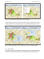
The GSHP screening tool indicates viable areas for the installation of open-loop GSHP
systems with a thermal capacity of at least 100 kilowatts. Developed at the 1:250,000
scale for England and Wales, it considers the most relevant hydrogeological and
economic parameters, including productivity of the aquifer and depth to the source, as
well as extents of protected areas. Where data are available, the tool also provides
information on the scaling/corrosion potential, iron concentrations and licenced
abstractions within a search radius around the location of interest.
http://www.bgs.ac.uk/research/energy/geothermal/
GeoSure dataset (Part of BGS Ground Stability Hazard datasets)
GeoSure national datasets provide geological information about potential ground
movement or subsidence caused by collapsible deposits, compressible ground, landslides,
running sands, shrink swell or soluble rocks. Further information are available at:
http://www.bgs.ac.uk/products/geosure/home.html
Non-coal Mining Hazard dataset
The Mining Hazard (not including coal) dataset provides essential information for
planners and developers working in areas of former shallow underground mine workings
that may collapse. It draws together a diverse range of material derived from geology,
literature searches and expert knowledge to map voids resulting from past underground
mining activity. Note that mining of coals is excluded from this dataset. For further
information see: http://www.bgs.ac.uk/products/geohazards/miningHazard.html
Enquiries on past coal mining should be directed to the Coal Authority
(http://coal.decc.gov.uk/ ).
Corrosivity (ferrous) dataset
The dataset identifies where the ground conditions beneath the topsoil have potentially
‘corrosive’ or ‘aggressive’ characteristics, i.e. are likely to cause corrosion of
underground ductile iron assets.
14