1
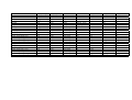
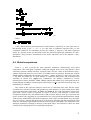
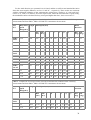
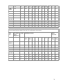
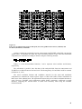
4.2. Header structure
Element name
WOCE_version
CONVENTIONS
long_name
Type
String
String
string
short_name
string
producer_agency
producer_institution
netcdf_version_id
product_version
creation_time
start_date
stop_date
time_resolution
string
string
string
string
string
string
string
string
spatial_resolution
platform_id
instrument
objective_method
south_latitude
north_latitude
west_longitude
east_longitude
string
string
string
string
float
float
float
float
Format
3.0
"COARDS/WOCE"
‘<scatterometer> <period> mean wind fields’
scatterometer ∈ {ERS-1, ERS-2, NSCAT}
period ∈ { weekly, monthly}
‘MWF-<scatterometer>-<period>’
scatterometer ∈ {E1, E2, N}
period ∈ {D,W,M}
‘IFREMER’
‘CERSAT’
‘3.4’
‘1.0’
‘YYYY-DDDTHH:MM:SS.SSS’
‘YYYY-DDDTHH:MM:SS.SSS’
‘YYYY-DDDTHH:MM:SS.SSS’
‘<T>’
T∈ { one week mean, one month mean}
‘1 degree’
{‘ERS-1’, ‘ERS-2’, ‘ADEOS’}
{‘AMI-Wind’, ‘NSCAT’
‘kriging’
+/-xx.yyyy [-90, 90]
+/-xx.yyyy [-90, 90]
xxx.yyyy [ -180, 180[
xxx.yyyy [ -180, 180[
4.2.1. WOCE_version
The mean wind fields are part of WOCE package. The current WOCE version is "3.0".
4.2.2. CONVENTIONS
The netCDF standard conventions which the product conforms to. The convention is always
"COARDS" that means Cooperative Ocean/Atmosphere Research Data Service. The information on
the standard can be found at http://ferret.wrc.noaa.gov/noaa_coop/coop_cdf_profile.html. Some
additional WOCE rules extend this convention.
4.2.3. long_name
A complete descriptive name for the product. The long_name has the format ‘sensor period mean
wind fields’ where sensor is the instrument or satellite (‘ERS-1’, ‘ERS-2’ and ‘NSCAT’) which
collected the raw data averaged on the grid and period is the time interval over which raw data are
averaged (‘daily’, ‘weekly’, ‘monthly’).
4.2.4. short_name
The official reference of the product. The format is ‘MWF-sensor_id-period_id’ where sensor_id
(‘E1’ for ERS-1, ‘E2’ for ERS-2, ‘N’ for NSCAT) is the identifier of the sensor used and period_id is
20