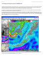
1
®
MetWise® Net Users Manual
V4.6 Build 1
Website: www.ensco.com/metwise
Email: [email protected]
ENSCO, Inc.
Aerospace Sciences and Engineering Division
1980 N. Atlantic Avenue, Suite 830
Cocoa Beach, Florida 32931
ENSCO, Inc.
MetWise Net Users Manual V4.6 Build 1
Table of Contents
Section 1. MetWise Net Layout
Section 1.1. MetWise Net Graphical User Interface (GUI)
Section 1.2. The Menu Bar
Section 1.3. The Tool Bar
Section 2.
MetWise Net Basic Controls
Section 2.1. Tooltips, Menus and Dialog Boxes
Section 2.2. Status Bar
Section 2.3. Image Export
Section 2.4. Setting MetWise Preferences
Section 3.
MetWise Net Graphic Controls
Section 3.1. Zoom In/Out
Section 3.2. Loop Properties Control Panel
Section 3.3. Overlaying Data Sets
Section 3.4. Line Contour Color Editing
Section 3.5. Line Contour Thickness Editing
Section 3.6. Individual Product Density Editing
Section 4.
Editing MetWise Net Baselines and Points
Section 5.
The MetWise Net Volume Browser
Section 5.1. Model Families
Section 5.2. The Volume Browser
Section 5.2.1. Loading Numerical Model Contour Data in the Volume Browser
Section 5.2.2. Loading Numerical Model Image Data in the Volume Browser
Section 5.2.3. Sources
Section 5.2.4. Fields and Planes
Section 5.2.5. Plan View
Section 5.2.6. Cross Section View
Section 5.2.7. Time Height View
Section 5.2.8. Model Sounding View
Section 6.
The MetWise Net Text Browser
Section 6.1. The Text Product Browser
Section 6.2. The AFOS Text Browser
Section 7.
MetWise Net Surface Data
Section 8.
MetWise Net NCEP/Hydro Data
Section 9. MetWise Net Upper Air Data
Section 9.1. Upper Air Plots
Section 9.2. Radiosonde Observation Plots (RAOB)
Section 9.3. Wind Profiler Plots
Section 10. MetWise Net Satellite Data
Section 11. MetWise Net Radar Data
Section 12. Creating and Using Procedures in MetWise Net
Section 13. MetWise Net Color Map Editor
Section 13.1. Upper Color and Lower Color Control
Section 13.2. The Color Bar
Section 13.3. Edit Controls
Section 13.4. An Example - Editing an IR Window Satellite Image
Section 13.5. Saving Color Edits as a Color Table
Section 14. Maps
Section 15. Contact Information
Appendix A. NOAAPort Text Data Description
Appendix B. Model Descriptions
ENSCO, Inc.
MetWise Net Users Manual V4.6 Build 1
1. MetWise Net Layout
The MetWise Net layout consists of a Graphical User Interface (GUI) with Menu bar, Tool Bar, one Primary and four Storage graphics windows and a
Status Bar.
Sections 1.1, 1.2 and 1.3 describe all of the features of the MetWise Net Layout.
return to contents
ENSCO, Inc.
MetWise Net Users Manual V4.6 Build 1
1.1 MetWise Net Graphical User Interface (GUI)
The MetWise Net GUI (Figure 1.1) has 5 main components; the Primary Window, four Storage Windows, the Menu Bar, the Tool Bar, and the Status
Bar.
The primary window is the large window on the right. This is the active window, in which products are downloaded, edited, viewed and looped. The
product displayed in the primary window can be moved to a storage window by right-clicking on one of the storage windows. This swaps what is in
the storage window with what is in the primary window.
Figure 1.1. MetWise Net GUI displaying Menu Bar, Tool Bar, Status Bar, Storage Windows, and Primary Window.
The storage windows are the small windows on the left side of the GUI. These four windows are used to save four sets of any type of data, so the
data is ready to view again without having to reload the data in the primary window. For example, to swap the product in the primary window with the
bottom left storage window, right-click on the storage window.
return to contents
ENSCO, Inc.
MetWise Net Users Manual V4.6 Build 1
1.2 The Menu Bar
The Menu Bar (Figure 1.2) provides access to all MetWise Net functions via drop-down menus. When an item is clicked, a drop-down list of
meteorological products or MetWise Net controls will open. Most entries on the drop-down menus will be available if the text is black, and not
available if the text is grayed-out.
Figure 1.2. MetWise Net Menu Bar.
For example, in the drop-down menu in Figure 1.3, the “10km Radar Coded Msg” may be selected, but the other radar choices are not available.
Figure 1.3. Drop-down list of selections under the “Radar” category.
The primary functions of each category in the Menu Bar are described in Table 1.1.
Table 1.1
Category
Description
Opens a list with choices to create, edit or open “Procedures”, to open the “Text Browser”, to “Export” or “Print” images
from the current frame or all frames, and to “Exit” MetWise Net.
Opens a drop-down menu to control the display in the primary window. Most of these controls are also all located on the Tool
Bar.
Used to open “Loop Properties”, “Image Properties” and “Preferences”.
Provides access to numerical weather prediction model graphics.
Accesses observations such as surface data, maritime observations, and lightning plots (when activated).
Opens datasets that are issued through the Storm Prediction Center, Tropical Prediction Center, Hydrometeorological
Prediction Center, Marine Prediction Center and Climatological Prediction Center.
Accesses upper air plots, skew-T's and hodographs.
Accesses satellite imagery.
Access the 10 km Radar Coded Message graphic, individual WSR-88D radar sites or regional WSR-88D radar mosaics.
A menu of map overlays, including lakes, cities, interstate highways, WSR-88D sites, counties, etc.
Accesses this MetWise Net User Manual in a web browser.
Loads model data using the model valid time sequence.
Sets the time interval between automatic product reloads.
The Valid Time Sequence (Figure 1.4) loads the current valid time sequence of model data from the Volume menu. When selecting a model from the
Volume menu, the Valid Time Sequence gives users control over different model run times. The default selection, Valid Time Seq, loads the chosen
model in all the frames needed for a complete model run forecast. Sometimes the first model times are loaded at the end, just to fill up the frames.
The option Latest Run only loads the latest model run for the model chosen. Previous Run just loads the run previous through to the latest run to fill
up the available frames. Previous Valid Time Seq is the same as Valid Time Seq but uses model data from the previous model run.
Figure 1.4. Valid Time Seq drop-down menu provides a user-selectable model time selection.
Once a product is loaded from the Menu Bar, that product will not update unless the user manually clicks the Reload button as described in Section
1.3 or invokes an auto reload/refresh using the Refresh drop-down menu as shown in Figure 1.5. If the user click the Refresh drop-down menu, they
can then set the time interval between automatic product reloads. This may be useful for continual updates of radar volume scans which occur about
every 5 minutes, satellite images which are available about every 15 minutes and surface observations (METARS) which are available about every 60
minutes.
Figure 1.5. Refresh drop-down menu provides a user-selectable automatic product refresh/reload.
When the user selects a refresh interval, the Status Bar will briefly display a message indicating the auto-refresh has been set and the refresh interval
will be continuously displayed to the left of the current time (Figure 1.5).
Figure 1.5. Drop-down list of selections under the “Radar” category.
return to contents
ENSCO, Inc.
MetWise Net Users Manual V4.6 Build 1
1.3 The Tool Bar
The Tool Bar (Figure 1.4) consists of a series of buttons that control the display in the current frame.
Figure 1.4. MetWise Net Tool Bar.
The primary functions of each button in the Tool Bar are described in Table 1.2.
Table 1.2
Category
Description
The globe icon indicates the data download process. Once a data set is selected, the globe will spin, indicating that the
download of data is in progress.
Pull down menu for selecting the map scale in the primary graphics window.
Clears all products from primary graphics window.
Reloads/refreshes all products in primary graphics window.
Returns to the first frame in the loop in the primary graphics window.
Steps back one frame in the loop.
Steps forward one frame in the loop.
Moves forward to the last frame in the loop in the primary graphics window.
Toggles the loop off and on in the primary graphics window.
Opens the Loop Properties control panel to control loop speeds.
Opens the Color Map Editor to edit the image loop in the primary graphics window.
Toggles the view in the current frame between the radar chooser and normal views. In the radar chooser view, a new
window will open which permits selection of an individual WSR-88D site to view.
Activates and displays the baselines and points in the primary window. Allows editing the characteristics of the baselines
and points.
Controls the number of frames in the loop loaded in the primary graphics window.
Sets the magnification of the text displayed in the primary graphics window.
Sets the global density of data in the primary graphics window.
return to contents
ENSCO, Inc.
MetWise Net Users Manual V4.6 Build 1
2 MetWise Net Basic Controls
MetWise Net offers many different tools to assist with navigation. Each is described in Section 2, and an example image of each is available to
augment the description.
return to contents
ENSCO, Inc.
MetWise Net Users Manual V4.6 Build 1
2.1 Tooltips, Menus and Dialog Boxes
Tooltips in MetWise Net describe the function of the buttons on the tool bar. By moving the pointer over an item on the tool bar, a tag pops open to
describe the purpose of the button selected. An example of a tooltip is shown in Figure 2.1.
Figure 2.1. Example of a tooltip. When the pointer is placed over the "Reload" button, a box opens at the base of the pointer describing the
function of the button.
Pull-down menus (Figure 2.2) are activated when the pointer is placed over one of the titles on the menu bar.
Figure 2.2. Example of a pull-down menu. A pull-down menu is displayed when the pointer is held over a title on the menu bar.
Some pull-down menus have sub-menus called cascading menus (). A pull-down menu has a cascading menu if it has a black arrow on the right of
the item in the pull-down menu.
Figure 2.3. Example of cascading menus. A cascading menu is displayed when the pointer is held over a pull-down menu item with a black arrow
to the right of the pull-down menu item.
Option menus are the menus that appear as a rectangle, and when clicked open up into a drop down menu. Option menus include the map view,
frame and density settings on the toolbar.
Figure 2.4. Example of an option menu. A drop-down menu is displayed by clicking on an option menu.
Pop-up menus are available in most situations by right-clicking on an item or the MetWise Net primary window. An example of a pop-up menu is
shown in Figure 2.5.
Figure 2.5. Example of a pop-up menu. A pop-up menu is displayed by right clicking on an item or in the primary window.
Dialog Boxes are windows that open via a menu or toolbar selection. An example of a dialog box are the Loop Properties dialog box and the Color
Map Editor dialog box.
Figure 2.6. Example of a dialog box showing the color map editor for a satellite image.
return to contents
ENSCO, Inc.
MetWise Net Users Manual V4.6 Build 1
2.2 Status Bar
The status bar (Figure 2.7) is displayed across the bottom of the MetWise Net window, and indicates the status of MetWise Net , the number of
frames displayed, the current refresh state and the date and the current GMT time (based on the computer’s clock that MetWise Net is running on).
By clicking on the arrow to the right of the word "Status", a window is displayed with all the status messages from the MetWise Net session. An
example of a Status Message is shown in Figure 2.8.
Figure 2.7. Status Bar
Figure 2.8. Status Message window.
return to contents
ENSCO, Inc.
MetWise Net Users Manual V4.6 Build 1
2.3 Image Export
Images can be exported as GIF or JPEG files by selecting the “File” drop-down from the Menu Bar and then select the “Export” cascading menu as
shown in Figure 2.9. The Current Frame in the Primary Window or All Frames in the loop of the Primary Window can be exported. After selecting
either “Current Frame” or “All Frames”, a dialog box opens and prompts for a name for the image(s) (MetWise Net gives them a default name) and
location on the hard drive. The default location where MetWise Net saves them (if MetWise Net is installed on drive C) is C:\ metwisenet\export as
shown in Figure 2.10.
Figure 2.9. Image Export drop-down menu.
Figure 2.10. Drop-down menu showing default location where export images are saved.
return to contents
ENSCO, Inc.
MetWise Net Users Manual V4.6 Build 1
2.4 Setting MetWise Net Preferences
The MetWise Net Preferences dialog box is accessed through the “Options” menu on the menu bar (Figure 2.11). There are 3 tabs to select in the
Preferences dialog box: General, Colors and Help. The General tab (Figure 2.12) sets the Primary View Port Size, Radar Chooser Size, Default
Radar Site, Number of Baselines, Number of Points, Cache Recycle Time, Maximum num Frames and Default num Frames. The Color tab (Figure
2.13) sets the colors that MetWise Net will use as defaults for the Default Map Color, Product Color Set and Background Map Color Set. Finally, the
Help tab (Figure 2.14) shows which web browser will be used when accessing this user manual from MetWise Net (this is done by default during
MetWise Net installation) and the URL of this user manual in HTML format (also done by default).
Figure 2.11. Selecting the Preferences dialog box from the Options menu.
Figure 2.12. Preferences General dialog box.
Figure 2.13. Preferences Colors dialog box.
Figure 2.14. Preferences Help dialog box.
return to contents
ENSCO, Inc.
MetWise Net Users Manual V4.6 Build 1
3 MetWise Net Graphic Controls
MetWise Net offers various tools to assist with graphic displays. Each is described in Section 3, and an example image of each is available to
augment the description.
return to contents
ENSCO, Inc.
MetWise Net Users Manual V4.6 Build 1
3.1 Zoom In/Out
MetWise Net is designed to allow users to easily zoom in and out on data sets. Remember though, when zooming in, detail can be lost on certain
types of data. It is best to load data on the smallest map scale possible in the primary window. This way, the highest resolution data will be loaded,
and the need to zoom will be minimized.
There are two ways to zoom in on data. With a three-button mouse, simply place the cursor over the spot to zoom in on, and middle-click the mouse.
With a two-button mouse, hold down the Alt key on the keyboard while left-clicking the mouse. With a laptop computer, hold down the Alt key and
either press the touch pad or left-click.
To zoom out, simply left-click the mouse.
return to contents
ENSCO, Inc.
MetWise Net Users Manual V4.6 Build 1
3.2 Loop Properties Control Panel
MetWise Net can create loops of almost any type of data, as long as more than one frame is selected on the toolbar (Figure 3.1). Loops are controlled
with the buttons on the toolbar (first frame , previous frame , next frame , last frame , loop on/off ). The speed of the loop is controlled
using the Loop Properties Control Panel (Figure 3.2).
Figure 3.1. MetWise Net Toolbar showing the location of the loop controls (purple ellipse) and number of frames (red ellipse).
The Loop Properties Control Panel can be accessed by clicking the loop properties button (
) on the tool bar as shown in Figure 3.2.
Figure 3.2. MetWise Net Toolbar showing the location of the Loop Properties button.
In the Loop Properties Control Panel, the sliding bars control the speed of the loop and the amount of time it will dwell on the first and last frame as
shown in Figure 3.3.
Figure 3.3. Loop Properties Control Panel.
return to contents
ENSCO, Inc.
MetWise Net Users Manual V4.6 Build 1
3.3 Overlaying Data Sets
One strength of MetWise Net is the ability to overlay data sets. This is a powerful tool, and allows viewing of different types of data side-by-side. For
example, a loop of satellite data can be loaded, and then a loop of the NAM model's forecast 500 mb heights can be loaded. MetWise Net will timematch the NAM 500 mb heights to the satellite data already loaded in the primary window. Or, NAM, RUC and GFS 500 mb heights can be loaded in
the same window, providing a unique opportunity to compare how they differ or are similar for the same forecast time period.
Eight products can be loaded in the primary window at once, and only one may be of an image type (satellite, radar, model image). The window can
get cluttered and hard to read, so the products can be toggled on and off to make them easier to analyze. To toggle a product, left-click on the title of
the product in the bottom right of the primary. Actually, the product is still loaded, but it is not visible. The product can be viewed again by clicking the
title.
As a rule, two images cannot be overlaid, i.e. satellite and radar or model image and satellite/radar. Also, upper air data cannot be overlaid with any
other type, or plan view forecasts with time height or cross section forecasts.
return to contents
ENSCO, Inc.
MetWise Net Users Manual V4.6 Build 1
3.4 Line and Contour Editing
When several types of data using line contours are overlaid, MetWise Net automatically chooses the colors and thickness for the line contours.
Sometimes, it is desirable to change the color and/or thickness of the contour to make it easier to see. An example of how to do this follows.
Figure 3.3 shows the NAM 500MB Height contours (green) and Mean Sea Level Pressure (MSLP) contours (tan). To change the color of the MSLP
height to another color to make it easier to read, right-click the NAM Model MSLP product legend on the bottom right of the window. This opens a
cascading menu as shown in Figure 3.4.
Figure 3.3. Example of two contours overlaid – 500 mb Height (green) and Mean Sea Level Pressure (tan).
Figure 3.4. Cascading menu activated by right clicking on the product legend. In this example, “Set Colors” is selected.
Choose cyan by clicking on the color bar and the MSLP lines change to cyan as shown in Figure 3.5. If a desired color is not shown on the pop-up
color bar, a different color can be created by clicking on “choose color…”. By clicking “choose color…” the color editor window opens as shown in
Figure 3.6. Move the slider bars until desired color is displayed then click “Okay” or “Apply”.
Figure 3.5. Example of two contours overlaid after changing the color of the Mean Sea Level Pressure contours to cyan.
Figure 3.6. Color editor window.
return to contents
ENSCO, Inc.
MetWise Net Users Manual V4.6 Build 1
3.5 Line Contour Style Editing
When several types of data using line contours are overlaid, MetWise Net automatically draws all the contours with identical thickness. Sometimes, it
is desirable to change the thickness or style of the contour to make it easier to read. To change the thickness or style of the MSLP height, right-click
the NAM Model MSLP product legend on the bottom right of the window. The resulting cascading menu (Figure 3.7) has four line style settings. The
top is the default. By choosing the middle line, the MSLP lines are changed to a thicker line as shown in Figure 3.8.
Figure 3.7. Cascading menu activated by right clicking on the product legend. In this example, “Set Line Style” is selected.
Figure 3.8. Example of two contours overlaid after increasing the thickness of the Mean Sea Level Pressure contours.
return to contents
ENSCO, Inc.
MetWise Net Users Manual V4.6 Build 1
3.6 Individual Product Density Editing
When several types of data using line contours are overlaid, MetWise Net automatically defaults to the setting “Use Global” (Figure 3.9). This setting
can be overridden by selecting a different density from this menu. The lowest density is 0.33 and highest density is “Max”. Once a density is
selected, the data will be redrawn in the primary window. In the example shown in Figure 3.10, a density of “Max” was selected. Compare the
difference in MSLP (cyan) contour spacing over the US in Figures 3.9 and 3.10 – the spacing in Figure 3.9 is less dense.
Figure 3.9. Cascading menu activated by right clicking on the product legend. In this example, “Set Density” is selected.
Figure 3.10. Example of MSLP contours after changing the line density to “Max”.
return to contents
ENSCO, Inc.
MetWise Net Users Manual V4.6 Build 1
4 Editing MetWise Net Baselines and Points
MetWise Net provides the capability to edit the characteristics of the baselines and points; which are used to create Cross Section, Time-Height and
Sounding maps from the Volume Browser.
Selecting the baselines and points button (
window as shown in Figure 4.1.
) on the main MetWise Net toolbar, will display the baselines and points in the main MetWise Net
The product legend will load in the top right. Only one of the two (either baselines or points) is editable at one time, and MetWise Net will show which
is editable in parentheses. There are two ways to change the product that is editable:
1. Right click on the product that is listed as editable. When the menu appears, the Editable
item will be checked. Simply select Editable again to un-check it, and by default, the other
will become editable.
2. Right click on the product that is not editable. When the menu appears, select Editable
and the product will now become editable.
Figure 4.1. Baselines and points are displayed after selecting the baselines and points button from the main toolbar.
To edit the baselines or points themselves, simply place the cursor over a baseline or point (whichever is editable), and the cursor will change from an
arrow to a cross with 4 arrows. Then click the baseline or point and drag it to the location to use for viewing model data.
Baselines are not only movable, but are re-sizable. To re-size a baseline, place the cursor over an endpoint of a baseline, it will change into a cross
with 4 arrows, and move the end of the baseline to any location. Notice that the baseline can be moved and re-sized in this way. The baseline can be
oriented in any direction by "grabbing" an endpoint and moving it.
Once baselines and points are moved and re-sized, the changes are written into MetWise Net and will remain even if MetWise Net is closed and
restarted. To get back to the original settings, select the Baseline Tool button on the main MetWise Net toolbar to show the baselines and points in
the main window. Then right-click on either product in the top right to open the edit menu, and select Restore Defaults. This will put the baselines/
points back in their default location. Note that to restore defaults, the product selected must be editable.
return to contents
ENSCO, Inc.
MetWise Net Users Manual V4.6 Build 1
5 The MetWise Net Volume Browser
The Volume Browser is initiated by clicking on the Volume (
) button on the main MetWise Net toolbar which results in a pull-down list of
options for loading numerical model data into the primary window. The first choice is Browser…, then three groups of products: **Families**,
**Comparison Families** and **Surface Families**. Choosing Browser… will open a window (the volume browser) that will permit creating loops of
any available numerical model data. Products can be tailored using the Volume Browser allowing flexibility with what the products loaded into the
primary window. On the other hand, choosing any model family, for example ETA Family, will load a set of 8 predetermined products into the primary
window. This method is easiest but does not provide any flexibility as far as what products can be viewed. **Comparison Families** selections load
comparisons of 500mb heights and MSLP from GFSGbl, ECMWF and UKMET models in a World map background view. **Surface
Families**selections load 8 surface parameters to include surface precipitation type icons, wind streamlines, dew point, MSLP, temperature, relative
humidity, winds and precipitation image from the GFS40 model in a CONUS map background view and from the RUC40 model in a regional map
background view.
Numerical model data can be animated, zoomed in and out, viewed in Plan View, Cross Section, Time Height, and Sounding; and loaded using line
contours or color contours (images).
A description of the models available in MetWise Net are shown in Appendix B.
return to contents
ENSCO, Inc.
MetWise Net Users Manual V4.6 Build 1
5.1 Model Familes
By selecting a model “family”, a predetermined set of 8 model products will be loaded in the primary window. For example, by selecting the
“Volume” button on the main MetWise Net toolbar and then “NAM” family, MetWise Net loads the following products automatically and the Product
Legends are displayed in the lower right corner of the window as shown in Figure 5.1:
●
●
●
●
●
●
●
●
Accumulated Precipitation
700MB Omega
1000MB-500MB Relative Humidity
700MB Height
1000MB-500MB Thickness
Model MSLP
500MB Vorticity
500MB Height
Figure 5.1. Resulting product display after selecting the NAM model from the Volume Browser on the main MetWise Net toolbar. The
8 pre-determined model parameter legends are displayed in the lower left primary window.
return to contents
ENSCO, Inc.
MetWise Net Users Manual V4.6 Build 1
5.2 The Volume Browser
When selecting “Browser…” from the MetWise Net “Volume” menu, the “Volume Browser” opens as shown in Figure 5.2. The Volume Browser
permits tailoring and loading of numerical model data to place into the primary window. The menu bar along the top of the Volume Browser is similar
to the main menu bar. Choosing File results in a single drop-down item which will exit the Volume Browser. Choosing Edit provides various options to
clear choices of all, sources, fields, and planes or select all or none of the choices. There are two options under Tools: Baselines (used in loading
cross sections), and Points (used in loading time-height forecasts). The Plan view will open a menu with choices of how to view the data, e.g. Plan
view, Cross Section, Time Height or Sounding.
Below the menu bar are three smaller windows for choosing Sources (different numerical models), Fields (500mb height, MSLP, temperature,
thickness, etc), and Planes (500mb level, 300K surface, 1500 meters, 1000-500mb layer, etc.).
Figure 5.2. The Volume Browser.
After choosing a Source, Field and a Plane that MetWise Net is capable of loading, the product will appear in the Product window below the three
smaller windows. If a configuration is chosen that can't be loaded, such as a Field that the model doesn't have, or a Plane that the Field doesn't apply
to, the product will simply not appear in the Products window.
return to contents
ENSCO, Inc.
MetWise Net Users Manual V4.6 Build 1
5.2.1 Loading Numerical Model Contour Data in the Volume Browser
This example will load a loop of GFS40 Mean Sea Level Pressure and 500 mb heights into the primary window. First, choose how many frames to
load. Each GFS40 run goes out 240 hours, so 21 frames would be enough to get all 240 hours in 12-hour increments. Chose 21 frames from the main
toolbar then make sure that the map scale (CONUS, Regional, N. Hemisphere, etc.) applies to the model selected. On the main MetWise Net toolbar,
Click Volume, then Browser. The default is Plan View, which is how to view 500 Mb heights. Click Source, then GFS40 , then under Fields choose
Basic, then MSL Press (Surface will be automatically chosen under Planes) then chose Basic again and Height. Finally, under Planes select 500 mb.
The GFS40 Surface MSL Press and GFS40 500 mb Height appears in the Product window. The volume browser should now look like Figure 5.3.
Figure 5.3. The Volume Browser showing an example of two products ready to be loaded into the MetWise Net primary window.
To load the product, click the Load button at the bottom of the Volume Browser window and the product will load in the primary window (Figure 5.4).
Once it is finished loading, another loop can be created to overlay in the primary window. Remember only 8 products will load in the primary window,
only one being an image product type.
Figure 5.4. Example of GFS40 Mean Sea Level Pressure and 500 mb Height loaded into primary window using the Volume Browser.
return to contents
ENSCO, Inc.
MetWise Net Users Manual V4.6 Build 1
5.2.2 Loading Numerical Model Image Data in the Volume Browser
In addition to loading model data with the volume browser as contours, most data can be loaded as an image. In this example, load the temperature
image (not contour lines) at 500 mb into the primary window, overlaying the 500 mb heights and MSL Pressure already there. Under Fields, select
Basic then Temperature. The GFS40 Surface Temperature and GFS40 500 Mb Temperature titles appear in the Product window. This is because
GFS40 was already selected under Sources and Surface and 500mb under Planes. Left click on the GFS40 Surface Temperature title to deselect it
since the surface temperature is not to be displayed. The volume browser now appears as in Figure 5.5. It indicates there is now 1 product selected for
loading: GFS40 500 mb Temperature. Since the GFS40 Surface MSL Press and GFS40 500 mb Height products were already loaded, they are no
longer highlighted in yellow.
Figure 5.5. The Volume Browser showing an example of the GFS40 500 mb Temperature ready to be loaded into the MetWise Net primary window.
Next, right-click on the GFS40 500 Mb Temperature which is highlighted in the Product window to invoke a small window pop up within the Volume
Browser as shown in Figure 5.6.
Figure 5.6. The Volume Browser showing an example of the drop-down menu to change a contour product to an image product.
Now select GFS40 500 Mb Temperature Image the Volume Browser so that the window now looks like Figure 5.7. To load the product, click the Load
button at the bottom of the Volume Browser window and the GFS40 500 mb Temperature Image will load in the primary window with the GFS40 MSL
Pressure and 500 Mb Height as shown in Figure 5.8.
*** Keep in mind that image-type data takes longer to load than contour-type data.***
Figure 5.7. The Volume Browser showing an example of the image product ready to be loaded into the MetWise Net primary window.
Figure 5.8. Example of GFS40 500 mb Temperature Image added to the existing GFS40 Mean Sea Level Pressure and 500 mb Height products loaded into
primary window using the Volume Browser.
return to contents
ENSCO, Inc.
MetWise Net Users Manual V4.6 Build 1
5.2.3 Sources
The available items on the Source menu depends on the map scale chosen from the MetWise Net toolbar prior to opening the Volume Browser. For
example, the RUC is not available when the map scale is N. Hemisphere in the primary window. This is because the RUC domain extends just
beyond CONUS. The map in the primary window would have to be North American or smaller scale for the RUC to be available. To choose a model,
click Source and then choose a model. If the model of choice is not available when the Volume Browser is opened and Source is selected, close the
Volume Browser and change the map scale in the primary window using the tool bar.
return to contents
ENSCO, Inc.
MetWise Net Users Manual V4.6 Build 1
5.2.4 Fields and Panes
There are four ways to view numerical model data using the volume browser. They include Plan View, Cross Section, Time Height and Sounding.
Each one of these will yield different menus under Fields and Planes.
The menus under Fields are the same for the top three except for the menu Sfc/2D in the Plan View. The Fields menu for Sounding has only one submenu, Thermo. The Basic, Derived and Other menus remain present for the top 3 views. A list of commonly used products from each of the three is
shown below.
Basic
Height
Thickness
Pressure
MSL Pressure
Temperature
Potential Temperature
Dewpoint
Wind
Omega
return to contents
Derived
Vorticity
Divergence
Temperature Advection
Moisture Advection
Geostrophic Wind
Q Vectors
Div Q
Other
Cloud Cover
Precipitation
ENSCO, Inc.
MetWise Net Users Manual V4.6 Build 1
5.2.5 Plan View
The Plan View is shown in Figure 5.9.The menus specific to the Plan View are Sfc/2D under Fields, and all four Planes menus. Plan View is basically
a bird's-eye view of data that is plotted on a horizontal or pseudo-horizontal map. It is the most common way to view meteorological data.
The Sfc/2D menu has extra fields that are usually only plotted at the surface. They include Precipitation, 6 and 24-hour Precipitation, Precipitable
Water, Lifted Index, CAPE, CIN, Helicity, Mixing Ratio and Fire Index. If any Field from the Sfc/2D menu is chosen, Surface must also be chosen from
the Misc menu under Planes. Sometimes this is done automatically, and sometimes the user must specify Surface.
The Planes menus in Plan View are fairly straightforward. The Pres menu contains options at various pressure levels in the atmosphere (250 Mb, 500
Mb, etc.). The Theta menu has various Theta surfaces (300K, 310K). The Hgt menu permits plotting data at a specific height (6000 ft, 2kmAgl).
Finally, the Misc menu has options like Surface, BL (boundary layer), and various layered products (1000-500mb, 850-500mb).
Figure 5.9. Volume Browser showing the Plan view’s Sources, Fields and Planes.
return to contents
ENSCO, Inc.
MetWise Net Users Manual V4.6 Build 1
5.2.6 Cross Section View
The Cross Section View is shown in Figure 5.10. The second choice of views in the Volume Browser is the Cross section. A cross section is a vertical
slice of the atmosphere between two points.
The menu in the Volume Browser specific to the Cross section is the Planes menu. There
is one menu to use to choose baselines for the cross section: Specified. The content of
this menu is shown on the right.
A cross section can be created using editable Baselines. With Cross section view
selected in the volume browser, under Planes in the Specified menu there are several
lines, e.g. LineA, LineB, etc. Each of these is a baseline to use to construct a cross
section. Before using these baselines for creating cross sections, the baselines and points
should be loaded in the MetWise Net primary window, and moved to locations from where
the data is of interest to create the cross section as described in Section 4
Figure 5.10. Volume Browser showing the Cross section’s Sources, Fields, and Planes.
For example, to create a cross section of temperature contours and a relative humidity image along LineA first, load the baselines in the MetWise Net
primary window, and move LineA to a position shown in Figure 5.11. Select 8 frames on the MetWise Net tool bar, then Volume from the MetWise Net
menu bar and click Browser. When the Volume Browser opens, select Cross section in the top menu. Next, select ETA from Sources, Temperature
and Rel Humidity from the Basic menu under Fields, and under Planes select LineA in the Specified menu. Right click on “ETA LineA Rel Humidity”
and choose “ETA LineA Rel Humidity Image” from the pop-up menu. Ensure both products are highlighted as shown in Figure 5.12 and click Load. A
loop of temperature contours and a relative humidity image in cross section view loads in the MetWise Net primary window as shown in Figure 5.13.
The location of the cross section is shown in plan view in a small inset on the top right of the primary window to show where the cross section is
located.
Figure 5.11. Editable Baseline “Line A” shown in the MetWise Net primary window.
Figure 5.12. Volume Browser showing the selection of the Source (ETA model), Fields (Temperature and Relative Humidity) and Planes (LineA) for the
Cross section that will be displayed in the MetWise Net primary window.
Figure 5.13. MetWise Net primary window display of the cross section selected along LineA. The location of the cross section is shown in plan view in
the small inset on the top right of the primary window to show where the cross section is located.
return to contents
ENSCO, Inc.
MetWise Net Users Manual V4.6 Build 1
5.2.7 Time Height View
The Time Height View is shown in Figure 5.14. Time Height views display data for a point over the entire time span of the model. This feature will
show the forecast for a specific point over whatever time is available, in one frame.
A time height product can be created using editable Points. With Time height view
selected in the volume browser, under Planes in the Specified menu there are several
points, e.g. TsectA, TsectB, etc. Each of these is a point to use to construct a time height
section.
Before using these points for creating time height sections, the points should be loaded in
the MetWise Net primary window, and moved to locations from where the data is of
interest to create the time height section as described in Section 4.
Figure 5.14. Volume Browser showing the Time height’s Sources, Fields, and Planes.
For example, to create a time height section of temperature contours and a wind barbs at TsectA first, load the points in the MetWise Net primary
window, and move point A to a position shown in Figure 5.15. Select 8 frames on the MetWise Net tool bar, then Volume from the MetWise Net menu
bar and click Browser. When the Volume Browser opens, select Time height in the top menu. Next, select NAM80 from Sources, Temperature and
Wind from the Basic menu under Fields, and under Planes select TsectA in the Points menu. Ensure both products are highlighted as shown in
Figure 5.16 and click Load. A time height section view loads in the MetWise Net primary window as shown in Figure 5.17. The location of the time
height point A is shown in plan view in a small inset on the top right of the primary window.
Figure 5.15. Editable Points shown in the MetWise Net primary window.
Figure 5.16. Volume Browser showing the selection of the Source (NAM80), Fields (Temperature and Wind) and Planes (TsectA) for
the Time Height section that will be displayed in the MetWise Net primary window.
Figure 5.17. MetWise Net primary window display of the time height section selected at TsectA.
return to contents
ENSCO, Inc.
MetWise Net Users Manual V4.6 Build 1
5.2.8 Model Sounding View
The Model Sounding View is shown in Figure 5.18. Model soundings display a forecast sounding for a point over the entire time span of the model.
This feature will show the forecast for a specific point over whatever time is available, in multiple frames.
A model sounding product can be created using editable Points. With Sounding view
selected in the volume browser, under Planes in the Specified menu there are several
points, e.g. Sounding A, Sounding B, etc. Each of these is a point to use to construct a
model sounding.
Before using these points for creating model soundings, the points should be loaded in
the MetWise Net primary window, and moved to locations from where the data is of
interest to create the model sounding as described in Section 4.
Figure 5.18. Volume Browser showing the Sounding’s Sources, Fields, and Planes.
For example, to create a model sounding at Sounding A first, load the points in the MetWise Net primary window, and move point A to a position
shown in Figure 5.19. Select 8 frames on the MetWise Net tool bar, then Volume from the MetWise Net menu bar and click Browser. When the
Volume Browser opens, select Sounding in the top menu. Next, select NAM80 from Sources, Sounding from the Thermo menu under Fields, and
under Planes select Sounding A in the Points menu. Ensure the product is highlighted as shown in Figure 5.20 and click Load. A model sounding
view loads in the MetWise Net primary window as shown in Figure 5.21. The location of the model sounding point A is shown in plan view in a small
inset on the top left of the primary window.
Figure 5.19. Editable Points shown in the MetWise Net primary window.
Figure 5.20. Volume Browser showing the selection of the Source (NAM80), Fields (Sounding) and Planes (Sounding A) for the
Sounding that will be displayed in the MetWise Net primary window.
Figure 5.21. MetWise Net primary window display of the model sounding selected at Sounding A. The location of the sounding at point A is shown in
plan view in the small inset on the top left of the primary window.
return to contents
ENSCO, Inc.
MetWise Net Users Manual V4.6 Build 1
6 The MetWise Net Text Browser
The Text Browser allows users to view AFOS text products. Some example text products include:
NWS Forecasts/Discussions
Severe Weather Watches/Warnings
METAR Reports
Weather Summaries/Tables
The Text Browser consists of two separate windows: The Text Product Browser and the AFOS Browser. First the Text Product Browser is opened
from MetWise Net File menu then the AFOS Browser is opened from the Text Product Browser. The AFOS Browser is the interface where products
are selected to load into the Text Product Browser window.
return to contents
ENSCO, Inc.
MetWise Net Users Manual V4.6 Build 1
6.1 The Text Product Browser
The Text Product Browser is opened from the main MetWise Net window File menu by selecting Text Browser as shown in Figure 6.1. This will open
the Text Product Browser (Figure 6.2) where text products will be loaded and viewed.
Figure 6.1. Opening the MetWise Net Text Browser from the File menu.
Figure 6.2. Text Product Browser window.
In order to load text products into the Text Product Browser window, the AFOS Browser must be used. The AFOS Browser can be opened two ways:
using the button on the toolbar of the Text Product Browser, or by selecting File → AFOS Browser... from the Text Browser menu bar.
In the File menu of the Text Browser, includes selections to Export text to a file and to Close the Text Browser.
The contents of the Text Browser can be exported (saved) to a file by selecting Export from the File menu. By default, the file is saved (if MetWise Net
is on C: on your computer) in C:\ metwisenet\export. The extension.txt should be appended to the filename to save the data as a text file, or any other
compatible file format.
The menu bar also has an Options menu, which has one option, to clear or not clear AFOS Browser commands on load. The AFOS Commands can
be seen in the bottom left of the Text Product Browser window.
On the toolbar, clicking Load History will give a list of the last 15 products that have been loaded, and will permit re-loading them without using the
AFOS Browser.
WMO Search will search for available products. There are three ways to search: by WMO TTAAii, by CCCC, or by using both. Either code can be
entered in the bottom right boxes of the Text Browser and WMO Search can be selected. The TTAAii code would go in the first box, while the CCCC
code would go in the far right box. The results of the search of a TTAAii would show all of those type of products from every location; where a WMO
Search of a CCCC would show all report types from a specific location. A specific report can be found from a specific location by using both TTAAii
and CCCC. The components of the TTAAii are broken down as follows:
●
TT is product type, such as AB for weather text summaries, or SA for surface observations (METARs);
●
AA is the region of the origin of the report, such as AK for Alaska, or US for the United States;
●
and ii is the report number,
whereas CCCC is the 4 letter station identifier of the source of the report; such as KACY for Atlantic City, NJ or KMLB for Melbourne, FL.
An extensive list of text products referenced by TTAAii is available via the NOAAPort Text Data Description in Appendix A. A list of CCCC identifiers
can be found at the NWS CCCC Identifiers List at: http://205.156.54.206/cgi-bin/chg_show.pl?fn=XR-08CCCC-IDs.txt.
Accum is a check box that when checked, will accumulate text products in the Text Browser. When not checked, newly loaded products will over-write
text products that are present in the Text Browser.
Clear will clear all text products from the Text Product Browser, and lastly, the WMO TTAAii CCCC: boxes at the bottom right show the AFOS Product
Identifier Label (PIL) of the product that was last loaded. A list of AFOS PIL's and Associated Products from the NWS can be found at this URL:
http://205.156.54.206/nwws/listwmo.txt.
return to contents
ENSCO, Inc.
MetWise Net Users Manual V4.6 Build 1
6.2 The AFOS Text Browser
After the Text Product Browser is opened, the AFOS Text Browser must be opened to access the data (as described above). The AFOS Text
Browser is shown in Figure 6.3.
Figure 6.3. The AFOS Text Browser.
In the AFOS Text Browser, select the area of interest by selecting a region from the Origin option menu as shown in Figure 6.4. The options are:
West, Central, East and International. Once a region is selected, the list of stations from the selected region will load in the Node scroll list on the left.
To determine what station a 3-letter code represents, click the question mark icon to the right of the Node title, and a drop down menu will open with a
full title of each station that is visible in the scroll menu as shown in Figure 6.5. The question mark to the right of the other three headers (Category,
Designator and Display) yields a similar list showing the full title of each product.
A product type is selected from the Class option menu. The options for the Class menu are: Public, Aviation, Hydrology, Local Obs., Radar/Upper Air,
Watch/Warning, Fire Wx Air Poll., Agriculture, Marine, Administrative, Miscellaneous, National Guidance, Natl/Regl/Aviation, Severe Local Storm,
National Obs., Narr/Disc./Codes, Tables/Summaries and Hurricane/Tropical. Once a product type is selected from the Class menu, the product type
list will load in the Category scroll list.
Once a Node and Category are selected, if there are any available products, they will load in the Designator menu as shown in Figure 6.6. At this
point, the product can be loaded in the Text Browser Window by selecting the product under Designator and either click Load and Continue or Load
and Close. Load and Continue will load the product and keep the AFOS Browser open, and Load and Close will load the product and close the AFOS
Browser. Figure 6.7 shows the resultant Text Product Browser after selecting Load and Continue.
Figure 6.4. Choosing an Origin from the AFOS Text Browser.
Figure 6.5. By clicking the question mark next to the Node heading, a drop-down list of full station names is displayed.
Figure 6.6. AFOS Text Browser showing the Designator based on the selected Node and Category for the Public Class.
Figure 6.7. Resultant Text Product Browser showing a text advisory.
return to contents
ENSCO, Inc.
MetWise Net Users Manual V4.6 Build 1
7 The AFOS Text Browser
To access surface data in MetWise Net click on
on the menu bar. A menu opens with all the surface data that can be plotted. As with all other
menus, the availability of the data depends on what map is selected for the primary window. Data that is available will be black. Grayed-out items are
not available at the scale selected.
Data is grouped by type, most of it is surface data. Exceptions include cloud ceiling
height data under Other Plots, and GPS-IPWV data. The blue headings separate the
different products. **METAR** data is surface data that is reported from hundreds of
sites across the continent, generally hourly, **Maritime** includes data from bouys
and ships and **Hazards** includes lightning data (if available).
Loading these products is similar to any other type of data. First, select your number
of frames from the tool bar. Selecting 1 retrieves the latest data set or analysis.
Selecting more than 1 yields the number of sets or analyses starting with the most
recent and going back in time.
An East Regional METAR Station Plot of wind, temperature, dew point, surface pressure, sky cover and wind gust is shown in Figure 7.1. The data
looks sparsely plotted, but this is where zooming in on an area returns a higher density of data. By centering the mouse pointer on a location to zoom
in on and either holding down the Alt button and left clicking; or if using a 3 button mouse, clicking the center button. The resultant map is shown in
Figure 7.2. Now, instead of only three stations plotted in North Carolina as shown in Figure 7.1, there are many station plots. This illustrates how to
increase the density of data on a surface plot. Simply zoom in and MetWise Net shows a higher density of data, called progressive disclosure. The
other option is to use the global Density button on toolbar to increase the density of data.
Figure 7.1. East Regional METAR station plot of wind, temperature, dew point, surface pressure, sky cover and wind gust.
Figure 7.2. East Regional METAR station plot of wind, temperature, dew point, surface pressure, sky cover and wind gust after zooming in with the
mouse centered over North Carolina.
return to contents
ENSCO, Inc.
MetWise Net Users Manual V4.6 Build 1
8 MetWise Net NCEP/Hydro Data
To access NCEP/Hydro data in MetWise Net click on
on the menu bar.
A menu opens with real-time and forecast data from several major NOAA/NCEP
data centers. Data from the Storm Prediction Center (SPC), the Tropical Prediction
Center (TPC), NCEP Central Operations (NCO), the Hydrometeorological Prediction
Center (HPC), the Marine Prediction Center (MPC), the Climate Prediction Center
(CPC) and Hydrological products (Hydro) are available.
SPC includes convective outlooks, threat charts, and fire weather forecasts.
The TPC, through international agreement, has responsibility within the World Meteorological Organization to generate and coordinate tropical
cyclone analysis and forecast products for twenty-four countries in the Americas, Caribbean, and for the waters of the North Atlantic Ocean,
Caribbean Sea, Gulf of Mexico, and the eastern North Pacific Ocean.
HPC includes precipitation products, both analyses and forecasts, as well as weather depiction and front positions and forecasts. Also included with
HPC products are several NGM MOS forecast datasets.
MPC, Marine Guidance, includes many analyses and forecast products, including, but not limited to, surface pressure, fronts and winds, upper-air
streamlines, and wave height conditions and forecasts.
The CPC products are operational predictions of climate variability, real-time monitoring of climate and the required data bases, and assessments of
the origins of major climate anomalies. The products cover time scales from a week to seasons, extending into the future as far as technically
feasible, and cover the land, the ocean, and the atmosphere, extending into the stratosphere.
An example of an SPC product is the Threat Chart shown in Figure 8.1 which shows the 3-10 day precipitation threat assessment.
Figure 8.1. SPC 3-10 day Precipitation Forecast Threat Chart.
An example of an HPC product is the Freezing Level and Turbulence chart shown in Figure 8.2.
Figure 8.2. HPC Freezing Level and Turbulence Product.
An example of an MPC product is the North Atlantic Sea State Analysis chart shown in Figure 8.3.
Figure 8.3. MPC Atlantic Sea State Analysis Product.
return to contents
ENSCO, Inc.
9 MetWise Net Upper Air Data
The MetWise Net Upper Air menu includes all upper air observations
and forecasts.
There are four main sections: UA Plots, Model Graphics & CPC Charts
and **PROFILER**, **Aircraft** and **RAOB** (radiosonde
observations). Each product area is described in the next four subsections.
return to contents
MetWise Net Users Manual V4.6 Build 1
ENSCO, Inc.
MetWise Net Users Manual V4.6 Build 1
9.1 Upper Air Plots
Upper air plots are plan view plots of data that are observed twice daily, at 0000Z and 1200Z, at the North American stations shown in Figure 9.1. A
balloon is released from each station with sensors (radiosondes) attached that measure temperature, humidity and wind as it rises through the
atmosphere.
Figure 9.1. North American RAOB sites.
To load an upper air plot, choose
from the MetWise Net menu bar and point to UA Plots. A new menu will open with two sections:
**NCEP** and **RAOB**. Both have selections for standard pressure levels. NCEP plots display upper-air radiosonde observations (circle station
symbol), aircraft reports (square symbol), and satellite measurements (star symbol) as shown in Figure 9.2.
Figure 9.2. NCEP Upper Air Plots. Radiosonde observations are shown by the circle, aircraft reports by the square and satellite measurements by
the star.
The RAOB plots only display radiosonde observations . The latest observations will plot is the number of Frames is 1. Otherwise, by choosing more
than 1 Frame, the latest number of observation times will be displayed and can be looped. Also, similar to plotting surface data, upper air plots will not
display all the observations initially. Zooming once or twice will show more data. The upper air plot in Figure 9.3 is at 500 mb. It is similar to a METAR
surface plot, but has a couple differences. The parameters plotted are wind speed/direction indicated by the wind barb, temperature, dew point
depression, geopotential height and height tendency in tens of meters. These are usually available for the standard levels of 150 mb, 200 mb, 250
mb, 300 mb, 400 mb, 500 mb, 700 mb, 850 mb and 925 mb.
Figure 9.3. RAOB Upper Air Plots include radiosonde observations only.
return to contents
ENSCO, Inc.
MetWise Net Users Manual V4.6 Build 1
9.2 Radiosonde Observation Plots (RAOB)
Other types of plots that can be created using radiosonde data are available on MetWise Net in the upper air menu are skew-T diagrams, hodographs
and a list of convective parameters; and can be viewed up by clicking
and then selecting a sub-menu under **RAOB**. The location to
plot is chosen via the sub-menu. The same applies to RAOBS that applied to Upper Air Plots: by choosing one frame, the latest observation loads,
and more frames chosen yields that number of observations starting at the latest and going backward in time. When a station's RAOB is loaded, a
window opens with a skew-T, a hodograph and many convective weather parameters that are calculated from the data.
A skew-T diagram for Medford, OR (KMFR) is shown in Figure 9.4 and is a display of what the radiosonde recorded as it rose through the
atmosphere. There is a temperature trace, a dew point trace and wind barbs plotted on the far right.
Figure 9.4. Skew-T diagram from Medford, OR.
The hodograph is displayed in the bottom left of the primary window when a RAOB station is selected and loaded. It appears just below the skew-T
diagram. Without zooming in on the hodograph, there is minimal information displayed. By zooming on the hodograph twice, all the information is
displayed as shown in Figure 9.5.
Figure 9.5. Hodograph from the Skew-T display in Figure 9.4 after zooming in twice.
The convective parameters based on the radiosonde are displayed in the bottom right of the window, to the right of the hodograph. The information is
cropped out of the window by MetWise Net when it initially loads. By zooming on the data once, it will all appear fully in the MetWise Net primary
window as shown in Figure 9.6. All these convective parameters are calculated using the data observed by the radiosonde, and plotted on the skew-T
and hodograph. For definitions of what these parameters are, see the Glossary of Weather Terms from NWS WFO in Norman, Oklahoma.
Figure 9.6. Convective parameters based on the radiosonde observation after zooming in once.
return to contents
ENSCO, Inc.
MetWise Net Users Manual V4.6 Build 1
9.3 Wind Profiler Plots
Wind profiler data comes from the profiler sites shown in Figure 9.7. Wind profilers are Doppler radars that point nearly vertical and observe winds
based on a measure the energy after reflection due to atmospheric density changes. Upon analyzing this type of radar data, wind speed and direction
can be plotted from the ground up to about 11 km.
Figure 9.7. Locations of wind profiler sites.
Choosing Plots under **PROFILER** results in a cascading menu opening that permits choosing a level of the atmosphere for plotting profiler data.
This loads differently than the other profiler data, as the data is hourly and shown in plan view. Selecting one frame results in a display of the last
hourly observations, and more than one frame results in a display of that many hours previous, ending with the latest. Figure 9.8 is a plot of the wind
profilers at 500 mb.
Figure 9.9. Wind profiler observations at 500 mb.
When selecting
and choosing a profiler region under **PROFILER**, and then a profiler site in a cascading menu results in a display as
shown in Figure 9.10. Time is displayed along the x-axis with the oldest data on the right. Height is displayed in km on the left side of the y-axis and
pressure level in mb on the right side of the y-axis. Thus, each vertical line of wind barbs represents the speed and direction of the wind in the
atmosphere above the profiler at that time. By selecting one frame, a display of the last 12 hours of data will result. By selecting more than one frame,
say 3 frames, the last 3 12-hour data sets will be available for looping.
Figure 9.10. Time-height display from the Lathrop, MO wind profiler. Time is displayed along the x-axis with the oldest data on the right. Height is
displayed in km on the left side of the y-axis and pressure level in mb on the right side of the y-axis.
return to contents
ENSCO, Inc.
MetWise Net Users Manual V4.6 Build 1
10 MetWise Net Satellite Data
Satellite data can be viewed by clicking
from the MetWise
Net menu bar. There are eight different products available. The two
sets of products look identical but frequency of the images is
different. The first set of products are generally available every 15-30
minutes, and the second set under the heading NH/NA/US every
image show every available image as frequently as every 5 minutes.
However, this does not preclude the first set if images being available
at the same frequency as the images under the heading NH/NA/US
every image. Also, the images in the second set, NH/NA/US every
image, are only available on scales at CONUS or larger.
The 4 Sat Composite is only available on scales of N. Hemisphere
or larger. The four different satellite products are made up of a
combination of the NOAA GOES East (~75° West Lon), NOAA
GOES West (~135° West Lon), European Meteosat (~0° West Lon),
Indian INSAT (~83° East Lon) and Japanese GMS (~140° East Lon).
Some important guidelines to follow when loading satellite imagery are:
●
●
●
●
Always set the map scale in the primary window to the smallest possible scale before loading the data to ensure the highest resolution data will
be displayed. For example, if an IR Window is loaded on a CONUS map, MetWise Net displays the image with a resolution of 4 km. If the same
image is loaded on a Southeast US map, the image is displayed at a higher resolution as shown in Figure 10.1. Zooming in on satellite imagery
tends to degrade the image after one or two clicks, so always load satellite images on the smallest map scale possible prior to zooming in on
the map.
Satellite data loads as 'images' in MetWise Net. Only one type of image can be loaded in the primary window at a time, so loading a model
image and a satellite image, or a radar image and satellite image together is not possible.
Load only as many frames as needed. Always check the Frames box before loading satellite data since satellite data takes a longer time to
load than non-image data. This may not be as much of an issue for for high-speed broadband connections, but all MetWise Net products are
created on the server and then sent to the client computer, so it still takes longer to create images on the server than it does to create nonimage data on the server.
Visible images displayed in any of the CONUS regions have the highest resolution at 1 km and take the longest to create on the server, transmit
over the Internet and display on the client computer.
Figure 10.1. IR Window satellite image loaded on a CONUS map and zoomed to the southeast (left) and IR Window loaded directly on a South East
US map (right). The image on the left is more "pixely" since it is displayed at a lower resolution than the image on the right.
An example of an IR Window satellite image is shown in Figure 10.2. The emitted infrared (IR) radiation is enhanced and colorized. In the default
MetWise Net IR enhancement, warmer temperatures are darker, and colder temperatures get whiter, then become colored. The higher (colder) clouds
are generally found in the brighter white shades and then once the color enhancement is reached indicates where the highest clouds are located. This
can be seen by studying the temperature scale at the top of the MetWise Net primary window in Figure 10.2. The satellite image color map can be
edited as described in Section 14.
Figure 10.2. IR Window satellite image. The lower clouds are generally indicated by the darker gray-shaded clouds and the higher clouds by the
brighter white shaded clouds. The highest clouds are indicated by the color enhancement. The temperature scale associated with this satellite
image is displayed at the top of the MetWise Net primary window.
An example of a Water Vapor satellite image is shown in Figure 10.3. It shows the water vapor content of mainly the middle levels of the atmosphere.
Water vapor loops are also useful for viewing the large-scale movement of weather systems.
Figure 10.3. Water vapor satellite image. Dry areas in the middle atmosphere are represented by the darkest black regions while water vapor is
shown as lighter grays and white.
An example of a Visible satellite image is shown in Figure 10.4. It is very much like about what the human eye would see (minus the color) looking
down on the Earth from about 22,500 miles. The CONUS scale image has a resolution of 4km but higher resolution data is available at smaller map
scales.
Figure 10.4. Visible satellite image.
An example of a high resolution 1 km visible satellite image is shown in Figure 10.5. Visible satellite images displayed in one of the CONUS regional
maps are the highest resolution satellite images available in MetWise Net.
Figure 10.5. High resolution 1 km visible satellite image on the Northwest map.
An example of a multi-spectral satellite image is shown in Figure 10.6. This image subtracts the 3.9µ spectral band from the 11µ spectral band and
displays an image typically used for examining low level stratus or fog. It is often called the fog product, and can be used to analyze fog formation
during nighttime.
Figure 10.6. 11u-3.9u satellite image. Typically used for viewing low-level stratus and fog.
return to contents
ENSCO, Inc.
MetWise Net Users Manual V4.6 Build 1
11 MetWise Net Radar Data
MetWise Net displays data in one of two modes: regular view mode and radar chooser mode. In the regular view mode, MetWise Net can display the
National Weather Service's 10km radar coded message which is a coarse resolution CONUS radar image. In the radar chooser mode, MetWise Net
can display Level III data from all CONUS Weather Surveillance Radar 1988 Doppler (WSR-88D) sites.
To view individual WSR-88D radars across the United States, MetWise Net must be in the radar chooser mode.
The 10km Radar Coded Message, which is a coarse national composite of radar sites, can be viewed by clicking
menu. A 10km Radar Coded Message is shown in Figure 11.1.
on the MetWise Net main
Figure 11.1. National Weather Service 10 km Radar Coded Message.
Data from individual WSR-88D radar sites can be viewed by clicking the radar chooser icon
from the MetWise Net main menu. This opens a new
window, the Radar Chooser (Figure 11.2), and changes the view in the MetWise Net primary window to Weather Forecast Office (WFO) scale (Figure
11.3), at the default location. In this case, the default location is KMLB (Melbourne, Florida). The default radar site can be set in the Preferences
window (Figure 11.4) activated by choosing Options on the MetWise Net main menu. The Radar Chooser window shows all the radar sites available
as well as an overlay of the current national radar.
Figure 11.2. Radar Chooser window showing all of the WSR-88D radar sites, the default radar site (KMLB, Melbourne, Florida) and the current
national radar overlay.
Figure 11.3. WFO scale window in the MetWise Net primary window displaying the map for KMLB (Melbourne, Florida).
Figure 11.4. The Preferences window allows the default radar site to be set under the General tab. In this example, the Default Radar Site is kmlb
(Melbourne, Florida).
When the Radar Chooser is activated, the Home selection in the MetWise Net main menu becomes active (Figure 11.5). It contains choices for the
radar products available from the WSR-88D site currently set as shown in the Radar Chooser window. To change the radar site in the Radar Chooser
window, right-click on the Radar Chooser map closest to the WSR-88D site of interest. The green square with the white cross-hair will move to the
closest radar site to the point I clicked and load the corresponding WFO scale map in the primary window. Now data can be loaded in the primary
window for the selected site using the Home selection in the menu. The Radar Chooser window will remain active as long as the WFO scale map is
not changed to another scale.
Figure 11.5. The radar Home selection menu showing the radar products available for display on the WFO scale map.
An example of 0.5 Refl (0.5° elevation angle display of reflectivity) from KMLB is shown in Figure 11.6.
Figure 11.6. The 0.5 Refl product from KMLB. Reflectivity values are displayed in dBZ and color scaled as shown at the top of the primary window.
After data has been loaded and viewed in the Radar Chooser mode in the primary window, it can be moved to a storage window just like any other
type of data by right clicking in one of the storage windows. Once in the storage window, the storage window mode becomes Radar Chooser mode,
and MetWise Net will return the primary window to regular view mode.
Radar images may be overlaid (with non-image data), zoomed or edited just like any other type of data. Remember, that the radar view in the primary
window is on a WFO scale, and some types of data will not be available for overlay on such a small scale. Surface data is a common overlay with
WSR-88D radar data, as are many types of maps such as interstates, cities and lakes.
To exit the Radar Chooser mode, the Radar Chooser window can be closed by clicking the close window icon
Radar Chooser window or by clicking the radar chooser icon
regular view mode and a blank CONUS map.
in the upper-right corner of the
from the MetWise Net main menu, which will return the primary window to the
In addition to viewing individual radar sites, mosaic images are available in any of the CONUS regional maps. When a CONUS regional map is
displayed, the matching region name is displayed in the radar drop-down menu (Figure 11.7). It contains choices for the radar products available from
the WSR-88D sites available in the chosen region.
Figure 11.7. W Great Lakes radar menu showing the radar products available for display on the regional scale map.
Figure 11.8 shows an image of the mosaic 0.5 Refl product for the Northeast region. Users should be cautioned: the mosaic images are created in
real-time on the server using as many as 30 individual radar sites to make the mosaic product. Therefore, it make take well over a minute to create,
download and display eight frames of a radar mosaic image.
Figure 11.8. The mosaic 0.5 Refl product from all of the W Great Lakes radars. Reflectivity values are displayed in dBZ and color scaled as shown
at the top of the primary window.
return to contents
ENSCO, Inc.
MetWise Net Users Manual V4.6 Build 1
12 Creating and Using Procedures in MetWise Net
Creating loops of data with satellite, numerical model, radar, etc. can be time consuming. Procedures are like macros in that they allow users to save
certain groups of products that they have loaded, overlaid and edited and then re-display them whenever required. This way, the products do not
have to be recreated each time they are needed, the user can just open the saved procedure to load the product.
For example, if a user routinely views a model data loop overlaying 500 mb heights, 500 mb vorticity image, MSLP and 1000-500 mb thickness, a
Procedure can be created to reduce the process to a few mouse clicks.
To create a procedure, first use the Volume Browser to load the products to be displayed. In this example, select the CONUS map then open the
Volume Browser and select ETA as the source, load the 500 mb heights, 500 mb vorticity image, MSLP and 1000-500 mb thickness products, adjust
the line colors, density and thickness and choose zoom level. All of the parameters selected will be saved in the Procedure. Select File, Procedures,
New from the MetWise Net main menu as shown in Figure 12.1.
Figure 12.1. After loading selected products into the MetWise Net primary window, the MetWise Net main menu is used to save a new Procedure.
A window will open entitled Procedure: untitled1 as shown in Figure 12.2.
Figure 12.2. Procedure window invoked from the MetWise Net main menu.
Click Copy In to copy the current products in the primary window into the new procedure. This will save all products displayed including their zoom
level and number of frames in the loop. The Procedure window will now display the names of the products as shown in Figure 12.3.
Figure 12.3. Procedure window displays the products that will be saved with the new procedure after clicking Copy In.
Click Save As as shown in Figure 12.4 and the Input (Figure 12.5) window will open. Enter a descriptive name for the new procedure similar to that
as shown in Figure 12.5.
Figure 12.4. Procedure window displays the products that will be saved with the new procedure after clicking Save As.
Figure 12.5. The Input window allows the user to enter a descriptive name for the new procedure.
Click OK in the Input window and the procedure will be saved with the descriptive name. The Procedure window now displays the name of the new
procedure at the top of the window as shown in Figure 12.6. Click Close to close the Procedure window.
Figure 12.6. Procedure window displays the name of the procedure just saved at the top of the window.
To test the new procedure, clear the primary window and open the procedure by selecting File, Procedures, Open from the MetWise Net main
menu. The Open Procedure window will open. Click the name of the new procedure as shown in Figure 12.6 and click ok. The Procedure window will
open displaying the name of the procedure selected in the Open Procedure window and the products that are part of that procedure as shown in
Figure 12.7. Clicking Load will activate the selected procedure and load it in the primary window. Click close to close the Procedure window.
Figure 12.7. Open Procedure window displays the name of the new procedure. Clicking ok will open the Procedure window.
Figure 12.8. Procedure window displays the name of the new procedure and associated products. Clicking Load activates the
selected procedure and loads it in the primary window.
return to contents
ENSCO, Inc.
MetWise Net Users Manual V4.6 Build 1
13 MetWise Net Color Map Editor
Images (satellite, radar, numerical model image) loaded in the MetWise Net primary window can be edited using the Color Map Editor allowing a user
to change the image's colors. Image colors can be edited by clicking the Color Map Editor icon
from the MetWise Net main menu.
The Color Map Editor window is shown in Figure 13.1. The Color Bar in the center of the window is the main work place where the colors are set to
change images in the primary window. The two sections in the Color Map Editor used for selecting the colors on the Color Bar are called the Upper
Color and Lower Color. The Upper Color pertains to the top section of the Color Bar and the Lower Color to the bottom section of the color bar. In
Figure 13.1, the arrowhead Color Pointer labeled "NO DATA" is used to control the Upper Color and the arrowhead Color Pointer labeled "-110.0C" is
used to control the Lower Color. This Color Bar is the default color image for the IR Window satellite image. The bottom of the Color Map Editor
window contains buttons to control various aspects of the Color Bar which are discussed in detail later in this section.
Figure 13.1. Color Map Editor window.
When the Color Map Editor is opened, it displays the range of colors in the middle color bar that are present or possible in the image loaded in the
primary window. The slider arrows that are on top left and bottom right of the color bar are used to change these colors. This can be accomplished by
clicking and sliding the arrows directly, or using the small single or double arrows (<, <<, >, >>) to the left and right of the color bar. Then colors are
applied to the arrows and the colors can be changed by using Set, Fill or Interpolate. When the colors are edited in the Color Bar to the user's
satisfaction they are saved to the image in the primary window by clicking Apply.
return to contents
ENSCO, Inc.
MetWise Net Users Manual V4.6 Build 1
13.1 Upper Color and Lower Color Control
The Upper Color and Lower Color controls each contain three color sliders that control the Red, Green, and Blue colors within the image. These
controls are called the RGB slider bars which control the colors in the Color Wheel to the right of the RGB slider bars. When the editor is in its default
mode, the upper Color Wheel has the RGB values set to zero (black) and the lower color wheel RGB values set to 255 (white). Increasing the
brightness value makes the wheel visible. The Color Wheel Centroid (a circle with a dot in the middle) can be dragged around the Color Wheel to
change the color in the Color Swatch. To the top right of the Color Wheel box is the Color Swatch. Also, clicking anywhere in the top half of the Color
Bar (located in the middle of the dialog box), fills the top Color Swatch with the corresponding color; clicking anywhere in the lower half of the Color
Bar fills the bottom Color Swatch. The Set buttons insert a narrow line of color into the current Color Bar at the location of the Color Pointer. The color
inserted is the one displayed in the corresponding (i.e., upper or lower) Color Swatch. The Fill buttons replace the colors contained within the range
specified by the Color Pointers in the Color Bar with the colors in the upper or lower Color Swatch.
Figure 13.2. Upper Color and Lower Color RGB controls within the Color Map Editor window.
return to contents
ENSCO, Inc.
MetWise Net Users Manual V4.6 Build 1
13.2 The Color Bar
The Color Bar (Figure 13.3) contains the color table of the current image and is located in the middle of the Color Map Editor window. The arrowhead
Color Pointers along the top and bottom halves of the Color Bar can be dragged to delineate a range of the color table; that is, the portion of the Color
Bar contained between the top and bottom arrows. The Color Pointers move independently of one another, but they cannot move past each other. As
the Color Pointers are dragged along the Color Bar, they display the image values corresponding to the color pointed to. Thus, for example, if an
infrared satellite image is displayed, moving the Color Pointer shows the temperature values corresponding to the colors in the Color Bar. Note: As
the Color Pointers are moved, they are filled with the color they are pointing to. To either side of the Color Bar are left- and right-pointing arrows.
These are used to move the Color Pointers along the Color Bar an increment at a time. The “>” and “<” Buttons move the Color Pointers in smaller
increments than the “>>” and “<<” Buttons.
Figure 13.3. Color Bar controls within the Color Map Editor window.
return to contents
ENSCO, Inc.
MetWise Net Users Manual V4.6 Build 1
13.3 Edit Controls
The Edit controls are located at the bottom of the Color Map Editor window as shown in Figure 13.4. The function of each control is described below.
●
●
●
●
●
●
●
●
●
Interpolate: Fills the specified range with an RGB interpolation between the colors in the upper and lower Color Swatches.
Undo: Allows the user to successively undo changes made to the color table. (Not available at this time)
Redo: Successively redoes the last edit that was undone. (Not available at this time)
Revert: Returns the Color Bar (and the displayed image) to its original state.
Save: Saves changes made to a color table. If a read-only color table or a color table that is owned by another user is being edited this menu
button is disabled.
Save As...: Opens the Save As Dialog Box in which a new name cane be entered for the color table. The color table is saved in a file
containing the customized color tables for the current user. If the new name of the color table is the same as a name of an existing color table
in this file, a dialog box opens and asks the user whether or not to overwrite in existing color table.
Load...: Opens the folder with saved color tables; for example if there is a color table saved for IR satellite imagery, the user can open the
folder using Load and select the associated color table. The changes are made automatically to the Color Map Editor. To invoke the changes
to the image in the primary window, the user must click Apply.
Dismiss: Closes the Color Map Editor.
Apply: Applies the changes made in the Color Map Editor to the images in the primary window.
Figure 13.4. Edit controls within the Color Map Editor window.
return to contents
ENSCO, Inc.
MetWise Net Users Manual V4.6 Build 1
13.4 An Example - Editing an IR Window Satellite Image
Start by loading an IR Window satellite image (or loop) into the primary window as shown in Figure 13.5 and let's assume we want to focus on only
the colder temperatures, so we will edit out the warmer colors by making them black.
Figure 13.5. IR Window satellite image loaded with the MetWise Net default color map.
Once the satellite image has loaded in the primary window, select
from the MetWise Net Main menu and the Color Map Editor opens as shown in
Figure 13.6. The goal of this exercise is to change any shades of gray and white to all black, so that we may just see temperatures less than -29.5oC.
Figure 13.6. Color Map Editor window displaying the MetWise Net default color map for an IR Window satellite image.
Slide the bottom Color Pointer to the left until it displays -29.5C as shown in Figure 13.7. We will be changing the colors in the region between the two
Pointers (between the top Pointer, NO DATA, and the bottom pointer, -29.5C).
Figure 13.7. Color Map Editor window after the bottom Color Pointer has been moved to the left where it displays -29.5o C.
Next, we need to change the colors in the Color Bar that are between the two Pointers. We will make it all black, so all that will be left are the colors
representing the coldest temperatures below -29.5o C.
The easiest method is to use the color (black) already selected in the Upper Color editor. Simply click Fill in the Upper Color area, and the editor fills
the area between the Pointers in the color bar with the color selected in the Upper Color Swatch. Fill is the quickest way to change a range of the
color bar to all one color. Figure 13.8 shows what the Color Map Editor looks like after clicking Fill in the Upper Color editor - the color bar is now filled
black between the Pointers. Now select Apply from the bottom of the Editor, and the image in the primary window is changed. The resultant satellite
from the primary window image is shown in Figure 13.9.
Figure 13.8. Color Map Editor window after clicking "Fill" in the Upper Color window. The area between the Pointers is now solid black because the
Upper Color RGB values were all set to 0.
Figure 13.9. IR Window satellite image after changing all colors below -29.5o C to black.
Another method to change the color map would be to use the Lower Color editor to change the color of the bottom Color Pointer from white to black,
then Interpolate. Notice, as the Pointer is moved along the color bar, it changes color. The color of the Pointer represents what color it is pointing to
in the color bar. First, move the bottom Pointer to the left (as shown in Figure 13.7) then change the color in the Lower Color Color Swatch to black by
sliding the RGB slider bars all the way to the left (so they all read 0). The circle in the Lower Color editor will now be black (like the Upper Color editor)
as shown in Figure 13.10. Then select Set, which sets the color of the lower Pointer to black and inserts a black line in the Color Bar at the bottom
Pointer as shown in Figure 13.11. Finally click Interpolate, which fills the region between the Pointers of the color bar black, as it is interpolating from
black (top Pointer) to black (bottom Pointer). The resulting satellite image in the primary window is identical to the one in Figure 13.9
Figure 13.10. Color Map Editor window after the Lower Color RGB sliders have been moved to the left so they all read 0.
Figure 13.11. Color Map Editor window after clicking "Set" in the Lower Color area to change the bottom Pointer to black.
Figure 13.12. Color Map Editor window after clicking "Interpolate" in the bottom area to change the region between Pointers to black.
return to contents
ENSCO, Inc.
MetWise Net Users Manual V4.6 Build 1
13.5 Saving Color Edits as a Color Table
After editing images in the primary window, a user may save these changes as a Color Table. For example, if a user wanted to use the Color Editor to
show only the coldest clouds in an IR Window, as shown in Section 13.4, as a routine product, they can save it as a Color Table and load it on
demand and apply it to new satellite images instead of making the edits to the Color Bar each time.
After completing and applying the steps outlined in Section 13.4 to edit a color table, click Save As... and a dialog box opens with the folder of Color
Tables as shown in Figure 13.13. The default location for saving Color Tables in the in subdirectory called "custom". Choose a file name for Color
Table and click Save. The next time a user loads an IR Window satellite image into the primary window and wants to view just the cold clouds, they
can open the Color Map Editor and click Load. This opens a dialog box containing the "custom" folder with the Color Tables (Figure 13.14) and allows
the user to select the appropriate one and click Open. This loads the changes in the Color Bar and then selecting Apply changes the satellite image
in the primary window.
Figure 13.13. Save dialog box allows users to save custom Color Tables.
Figure 13.14. Open dialog box allows users to open saved Color Tables and apply them to an image in the primary window.
It is simple to change back to the original image in MetWise Net . If the Color Map Editor has been closed, open it again by clicking on the
icon
on the MetWise Net main menu. It will open showing the changes made to the images in the primary window. Click Revert and the Color Map Editor
and the images in the primary window will revert to the original configuration. Using the Color Map Editor takes practice to find out how it interpolates
colors, and to find out what images it works best with. When colors are changed, it changes all the images in the loop. Also, if changes are made to
an image, these can be saved in a Procedure as outlined in Section 12.
return to contents
ENSCO, Inc.
MetWise Net Users Manual V4.6 Build 1
14 Maps
In addition to overlaying all types of weather data, MetWise Net has a library of
maps that may be used in conjunction with the data for a more detailed analysis.
These maps include, but are not limited to, Interstates, Ocean Latitude and
Longitude, METAR sites, RAOB sites, WSR-88D sites and many others. One must
just look in the menu from the MetWise Net toolbar to find these maps. A sample
Maps menu is shown to the right.
When
is selected from the MetWise Net main menu, a menu opens with
similar choices. These maps may be used to help geolocate weather features in
MetWise Net . Remember, only 8 products may be loaded into the primary window
at one time, and only one of these may be of an image type. This does not include
maps, since 8 maps may be loaded into the primary window along with the 8
products.
Like the 8 products in the primary window, maps may be toggled on and off. To do this, right-click and hold anywhere in the primary window which will
display the pop-up menu shown in the bottom right of the primary window in Figure 14.1. In this figure, the Product Legend is currently displayed as
"US IR Sat Sun 17:31Z 01-Oct-06".
Figure 14.1. Right-clicking the mouse in the primary window will display a pop-up menu allowing the user to switch between Map Legends and
Product Legends.
Once the menu is open, move the cursor down, while still holding the right mouse button down, and select Show Map Legends. This will switch the
view in the bottom right of the primary window from showing product legends to showing map legends as shown in Figure 14.2. The Map Legend
displayed is "CONUS".
Figure 14.2. MetWise Net primary window now displays "CONUS" after selecting "Show Map Legends" from the pop-up menu.
A user can toggle on and off which map is visible in the primary window just like with products. The colors of the maps can be edited by right-clicking
a map legend and editing the color from the resulting pop-up menu.
To switch back to view the product legends, right-click and hold in the primary window, and select Show Product Legends.
return to contents
ENSCO, Inc.
MetWise Net Users Manual V4.6 Build 1
15 Contact Information
If this Users Manual does not answer specific questions you may have,SOHDVHFontact XVDWPHWZLVHQHW#HQVFRFRP
You may also view our Frequently Asked Questions for additional information at the MetWise Net web site at:ZZZHQVFRFRPPHWZLVHQHWIDT
ENSCO, Inc.
Aerospace Sciences and Engineering Division
1980 N. Atlantic Ave., Suite 30
Cocoa Beach, Florida 32931
Read about our entire MetWise family of products at ZZZHQVFRFRPPHWZLVH.
return to contents
ENSCO, Inc.
MetWise Net Users Manual V4.6 Build 1
Appendix A
NOAAPort TEXT DATA
Analysis and Summary Data
WMO header: A*
TT Explanation
Code Form
AB Weather summaries
TEXT
AC Convective/Cyclone discussions
TEXT
AI Ice discussions
FM 44 (ICEAN)
AO Ozone discussions
TEXT
AR Radar discussions
TEXT
AS Surface discussions/analyses
FM 45 (IAC), FM 46 (IAC FLEET), TEXT
AT Satellite discussions
FM 85 (SAREP)
AU Upper air discussions
FM 45 (IAC)
AX Tropical and miscellaneous discussions TEXT
Selected WMO Headers
TTAAII
ABAK01
ABAK02
ABAK32
ABCN01
ABIO10
ABNA26
ABNT20
ABPW10
ABPZ20
ABUS21
ABUS23
ABUS24
ABUS25
ABUS30
ABUS34
ABXX06
ABXX07
ACPA40
ACPN50
ACPW40
ACUS01
ACUS02
ACUS03
ADMN..
AEUS..
AG....
AGUS7.
ASHW40
ASHW50
ASUS1
ASUS4.
ASUS5.
ASUS6.
ATHW40
AWUS4.
AXNT20
AXPZ20
AXUS4.
AXXX01
AXXX02
CCCC
PANC
PANC
PANC
KWBC
PGTW
KWBC
KMIA
PGTW
KMIA
....
KWBC
KWBC
KWBC
....
....
KWBC
KWBC
PHFO
PHFO
PHFO
KWNS
KMNS
KWNS
KWBC
....
....
....
PHFO
PHFO
KWBC
....
....
....
....
....
KNHC
KNHC
....
KBOU
KBOU
Explanation
Alaska Weather Summary
Alaska Temperature And Precipitation Summary
Alaska Regional Weather Roundup
Canadian Temperature and Precipitation Table
Significant Tropical Weather Advisory for Indian Ocean
Temperature/Weather for International Cities
Tropical Atlantic & Caribbean weather outlook
Significant Tropical WEather Advisory for Western Pacific Ocean
Eastern Pacific tropical weather discussion
Temperature And Precipitation Table (twice daily)
Temperature/Weather for Western United States (hourly)
Temperature/Weather for Eastern United States (hourly)
Temperature/Weather for Central United States (hourly)
State Weather Summaries
Public Information Statement
Foreign Temperature And Weather Table
Latin American Temp And Weather Table
Tropical Weather Discussion Eastern Pacific
Tropical Weather Discussion Central Pacific
Tropical Weather Discussion Western Pacific
Convective Outlook...Day 1
Convective Outlook...Day 2
Convective Outlook...Day 3
Administrative Messages
Air Quality Index Reports
Marine Interpretation Message, Coastal and Buoy Wind Forecasts
Hydrometeorological Discussions
Hawaiian Islands Hourly Weather Roundup
Hawaii Temperature and Precipitation Summary
Surface Analysis, Frontal And Pressure System Locations
State Hourly Weather Roundups
State Temperature and Precipitation Table
Regional Temperature and Precipitation Summary
Hawaiian Islands Satellite Interpretation
Area Weather Summary
Tropical Weather Discussion, Atlantic & Caribbean
Tropical Weather Discussion, Pacific
Miscellaneous Discussions
NOAA Solar and Geophysical Activity Summary
NOAA Solar Region Summary
Climatic Data
Filename: cli.wmo
WMO header: C*
TT Explanation
Code Form
CA Climatic anomalies
TEXT
CE Monthly data - upper air
FM 76 (CLIMAT TEMP SHIP)
CH Monthly data - surface
FM 72 (CLIMAT SHIP)
CO Monthly data - ocean areas FM 73 (NACLI, CLINP, SPCLI, CLISA, INCLI)
CS Monthly data - surface
FM 71 (CLIMAT)
CU Monthly data - upper air
FM 75 (CLIMAT TEMP)
Selected WMO Headers
TTAAII
CDAK4.
CDHW4.
CDUS27
CDUS4.
CS....
CSUS01
CSUS02
CSUS03
CSXX..
CXAK3.
CXUS3.
CXUS4.
CXUS6.
CCCC
PA..
PHFO
KZ..
....
....
....
....
....
KWBC
PA..
....
....
....
Explanation
Alaska Climate Report
Hawaii Climate Report
Climatic Data, DS Data
Climatic Report
CLIMAT Data
Monthly Climatic Summary
Daily Climatic Report
Miscellaneous Climatic Data
Monthly Mean Climatic Data
Alaska SCD Data
US SCD Data
US DSM Data
US SCD Data
Forecast Information
Filename: for.wmo
WMO header: F*
TT Explanation
Code Form
FA
Aviation forecasts
FM 53 (ARFOR)
FB
Upper level windows and temperatures FM 50 (WINTEM)
FC
Aerodrome forecasts (VT < 12hr)
FM 51 (TAF)
FD
Radiological trajectory
FM 57 (RADOF)
FE
Extended forecasts
TEXT
FF
Shipping forecasts
FM 46 (IAC FLEET)
FI
Iceberg forecasts
TEXT
FJ
Radio warning service
TEXT
FM Temperature extreme forecasts
TEXT
FO
Model guidance forecasts
Formatted TEXT
FP
Public forecasts
TEXT
FQ
Other shipping forecasts
TEXT
FR
Aviation route forecasts
FM 54 (ROFOR)
FS
Surface forecasts
FM 45 (IAC), FM 46 (IAC FLEET), TEXT
FT
Aerodrome forecasts (VT > 12hr)
FM 51 (TAF)
FU
Upper air forecasts
FM 45 (IAC)
FW Winter sports forecasts
TEXT
FX
Miscellaneous forecasts
TEXT
FZ
Shipping area forecasts
FM 61 (MAFOR)
Selected WMO Headers
TTAAII CCCC Explanation
FAAK0. PA.. Alaska Aviation Area Forecasts
FAAK2. KZAN Alaskan CWA
FAHW31 PHFO Hawaii Aviation Area Forecasts
FAUS20 KZ.. US Aviation Area Forecasts (MIS)
FAUS21 KZ.. US Aviation Area Forecasts (CWA)
FAUS5 .... Aviation Synopsis and VFR Clds/Wx
FA.... .... International Area Forecasts
FB.... .... Upper Air Wind and Temperature Forecasts (WINTEM Coded)
FC.... .... Terminal Aerodrome Forecasts (TAF Coded)
FD.... .... Winds Aloft Forecasts (Coded)
FEAK2. KWNO AVN Based Objective Guidance for Alaska
FEAK3. KWNO MRF MOS Guidance for Alaska
FECN20 KWBC AVN Statistical Max/Min Guidance for Canada
FECN21 KWBC MRF Statistical Max/Min Guidance for Canada
FEUS2. KWNO MRF MOS Guidance for US
FEXC[4567]. KWBC AVN Based Objective Guidance for Central US
FEXE[456]. KWBC
AVN Based Objective Guidance for Eastern US
FEXS[456]. KWBC
AVN Based Objective Guidance for Southern US
FEXW[456]. KWBC
AVN Based Objective Guidance for Western US
FGUS4. .... River Stage Statements and Forecasts
FGUS5. .... River Forecasts, Daily River and Lake Summaries
FGUS6. .... River Flood Watch Summary
FGUS71 KWBC National Hydrological Summary
FGUS8. .... River Forecasts
FI.... .... Ice, Ice Hazard and Iceberg Forecasts
FLUS4. .... Public Area Forecasts, Selected City Forecasts
FLUS8. .... Metropolitan Area Forecasts
FMCN3. CWAO Canadian City Forecasts
FNUS21 KWNS Fire Weather Discussion Day 1
FNUS22 KWNS Fire Weather Discussion Day 2
FNUS5. .... Fire Weather Forecasts for US
FNUS6. .... Rangeland and Grassland Fire Danger Statement
FNUS7. .... Regional Dispersion Forecasts
FNUS8. .... Fire Danger Rating Forecasts
FN.... .... General Fire Forecasts
FPAK04 PA.. Coded City Forecasts for Alaska
FPAK20 PA.. State Forecast Discussion for Alaska
FPAK5. PA.. Public Zone Forecasts for Alaska
FPAK7. PA.. Short Term Forecasts for Alaska
FPAU22 AMRF Interstate Cities Forecast for Australia
FPCA4. TJSJ Coded City Forcasts for NE Caribbean
FPCA5. TJSJ Public Zone Forecasts for NE Caribbean
FPCA6. TJSJ State Forecasts for NE Caribbean
FPCA7. TJSJ Short Term Forecasts for NE Caribbean
FPCN1. C... Public Forecasts for Canada
FPCN2. C... Marine Forecasts for Canada
FPCN5. C... Extended Forecasts for Canada
FPHW40 PHFO Coded City Forecasts for Hawaii
FPHW50 PHFO Public Zone Forecasts for Hawaii
FPHW60 PHFO State Forecast for Hawaii
FPHW70 PHFO Short Term Forecasts for Hawaii
FPUS1[023] KWNH Travelers Forecast Table
FPUS2[0123] KWNH Selected Cities Weather Summaries and Forecasts
FPUS4. .... Coded City Forecasts for US
FPUS5. .... Public Zone Forecasts for US
FPUS6. .... State Forecasts for US
FPUS7. .... Short Term Forecasts for US
FPUS8. .... Miscellaneous Forecasts for US
FQAU.. A... High Seas Forecasts for Australia
FQGX40 KWBC AVN Storm Surge Forecasts for Gulf of Mexico
FQUS2. KWBC NGM Based Storm Surge and Lake Wind Forecasts
FRUS4. .... Aviation Route Forecasts (TWEB)
FSUS4. .... Quantitative Precipitation Forecasts (QPF- SHEF Format)
FVXX20 KWBC Volcanic Ash Forecast
FXCN2. CWAO Ultraviolet Index for Canada
FXUS01 KWBC 48 Hour Forecast Discussion
FXUS02 KWBC Extended Forecast Discussion (3-7 Day)
FXUS03 KWNH Day 3 Forecast (Tabular Cities)
FXUS04 KWBC Quantitative Precipitation Discussion (Day 1)
FXUS04
FXUS05
FXUS06
FXUS06
FXUS07
FXUS10
FXUS11
FXUS5.
FXUS6.
FXUS7.
FXUS8.
FXXX04
FZUS5.
FZUS6.
FZUS7.
KWNH
KWNH
KWBC
KWNH
KWNH
KWNH
KWBC
....
....
....
....
KBOU
....
....
....
Day 4 Forecast (Tabular Cities)
Day 5 Forecast (Tabular Cities)
Prognostic Discussions for 6-10 and 8-14 Day Outlooks
Day 6 Forecast (Tabular Cities)
Day 7 Forecast (Tabular Cities)
Model Diagnostic Discussion
Extended Forecast MRF MOS Temps
MVF Forecasts
Area Forecast Discussions
FWM Forecasts
VER Data
Daily Space Weather Values (Solar/Geomagnetic)
Coastal Marine Forecasts
Great Lakes Forecasts
Marine Weather Statements
Model Output Information
Filename: mod.wmo
WMO header: FE*, FO*
Selected WMO Headers
TTAAII CCCC Explanation
FEAK2. KWNO AVN Based Objective Guidance for Alaska
FEAK3. KWNO MRF MOS Guidance for Alaska
FECN2. KWBC AVN Based Statistical Max/Min Guidance for Canada
FEPA20 KWNO MRF MOS Guidance for Pacific
FEUS2. KWNO MRF MOS Guidance for US
FEXC[4567]. KWNO AVN Based Objective Guidance for Central US
FEXE[456]. KWNO
AVN Based Objective Guidance for Eastern US
FEXS[456]. KWNO
AVN Based Objective Guidance for Southern US
FEXW[456]. KWNO
AVN Based Objective Guidance for Western US
FOAK2[0-4] KWNO
MRF Based Objective Guidance for Alaska
FOAK2[5-9] KWNO
NGM MOS Guidance for Alaska
FOAK3. KWNO AVN MOS Guidance for Alaska
FOCA51 KWNO Output from NGM (Cities, Caribbean)
FOCN7. KWNO Output from NGM (Cities, Canada)
FOGX77 KWNO Output from NGM (Locations, Gulf of Mexico)
FOHW50 KWNO Output from NGM (Cities, Hawaii)
FOUE[01]. KWNO
NGM MOS Guidance for Eastern US
FOUE[68]. KWNO
Output from NGM for Eastern US
FOUM0. KWNO NGM MOS Guidance for Mid US
FOUM[678]. KWNO
Output from NGM for Mid US
FOUS11 KWBC Probabilistic Heavy Snow and Icing Discussion
FOUS12 KWNO FTP Forecasts
FOUS14 KWNO NGM MOS Guidance
FOUS2. KWNO AVN MOS Guidance
FOUS30 KWBC Excessive Rainfall Potential Outlook
FOUS33 KWNO NGM MOS Max/Min Guidance
FOUS4. KWNO ETA FOUS Freezing Level and Relative Humidity Forecasts
FOUS50 KWNO Trajectory Forecasts
FOUS5. .... Digital Zone Forecasts
FOUS[67]. KWNO
Output from ETA Model
FOUS6. .... County Flash Flood Guidance
FOUS7. .... Headwater Flash Flood Guidance
FOUS8. .... FTP Forecasts
FOUS[89]. KWNO
Output from NGM Model
FOUW[01]. KWNO
NGM MOS Guidance for Western US
FOUW[78]. KWNO
Output from NGM Model for Western US
FOXC[4567]. KWBC MRF Based Objective Guidance for Central US
FOXE[456]. KWBC
MRF Based Objective Guidance for Eastern US
FOXS[456]. KWBC
MRF Based Objective Guidance for Southern US
FOXW[456]. KWBC
MRF Based Objective Guidance for Western US
FOXX.. KBOU Geoalert for Solar Activity
Terminal Forecasts (TAFs)
Filename: term.wmo
WMO header: FC*, FT*
Hydrological Data
Filename: rvr.wmo
WMO header: R*
Selected WMO Headers
TTAAII
RWUS4.
RRUS2.
RRUS..
RRUS4.
RRUS5.
RRUS6.
RRUS7.
RRUS8.
CCCC
....
KZ..
KWOH
....
....
....
....
....
Explanation
River Flood Statements
SHEF Data
RRS Data
Daily Hydrological Observations
River Reports
RR6 Data
RR7 Data
Hydrological Observations
Surface Data
Filename: sfc.wmo
WMO header: S*
TT Explanation
Code Form
SA
Aviation routine reports
FM 15 (METAR), SAO
SB
Radar reports (part A)
FM 20 (RADOB)
SC
Radar reports (part B)
FM 20 (RADOB)
SD
Radar reports (parts A & B)
FM 20 (RADOB), Formatted TEXT
SE
Earthquake/Seismic reports
Formatted TEXT
SF
Atmopsheric reports
FM 81 (SFAZI), FM 82 (SFLOC), FM 83 (SFAZU)
SG
Radiological data reports
FM 22 (RADREP)
SI
Intermediate synoptic hour reports FM12 (SYNOP), FM13 (SHIP)
SM Main synoptic hour reports
FM12 (SYNOP), FM13 (SHIP)
SN
Nonstandard synoptic reports
FM12 (SYNOP), FM13 (SHIP)
SO
Oceanographic data
TEXT
SP
Special aviation reports
FM 16 (SPECI)
SR
Hydrological reports
FM 67 (HYDRA)
ST
Sea ice reports
TEXT
SU
Snow depth reports
TEXT
SV
Lake ice reports
TEXT
SX
Miscellaneous reports
TEXT
Selected WMO Headers
TTAAII CCCC Explanation
SE.... .... Seismic Data
SF.... .... Sferic and Lightning Data
SHUS4. .... Agricultural Observations
SO.... .... Water Level, Tidal Prediction Data (SHEF Coded)
SXUS0. .... Agricultural Weather Observations
SXUS[2-8] KWOH
RRS Data
SXUS4. .... Miscellaneous Local Observations, COOP Reports
SXUS70 KWAL ????
SXUS8. .... Miscellaenous Marine Reports
SXUS99 ....
SXXX41 KWAL
SXXX90 KWAL
Record Events
????
????
Surface Observations
Filename: sao.wmo
WMO header: SA*, SP*
Selected WMO Headers
TTAAII CCCC
SA.... ....
SP.... ....
Explanation
Regular METAR Observtions
Special METAR Observations
Synoptic Observations
Filename: syn.wmo
WMO header: SI*, SM*, SN*, SS*
Selected WMO Headers
TTAAII
SI....
SM....
SN....
SS....
CCCC
....
....
....
....
Explanation
Intermediate Hour Synoptic Data
Main Hour Synoptic Data
Non-standard Syntopic Data
Other Synoptic Data
CMAN Observations
Filename: cman.wmo
WMO header: SXUS2[0123]
Radar Data
Filename: rad.wmo
WMO header: SDUS4* KWBC
Selected WMO Headers
TTAAII CCCC
SDUS4. KWBC
Explanation
Manually Digitized Radar Data
Radar Coded Message Data
Filename: rad.wmo
WMO header: SDUS4* KWBC
Selected WMO Headers
TTAAII CCCC
SDUS4. ....
Explanation
Radar Coded Message Data
Lightning Strike Data
Filename: .nldn
WMO header: SFUS41 KWBC
Satellite Data
Filename: sat.wmo
WMO header: T*
TT
Explanation
Code Form
TB
Satellite orbit parameters
Formatted TEXT
TC
Satellite cloud interpretations
FM 85 (SAREP)
TH
Satellite derived upper air soundings FM 86 (SATEM)
TI
Satellite imagery
NOAAPORT Satellite Format
TR
Clear radiance observations
FM 87 (SARAD)
TT
Sea surface temperatures
FM 88 (SATOB)
TW Winds and cloud temperatures
FM 88 (SATOB)
TX
TEXT
Miscellaneous satellite reports
Selected WMO Headers
TTAAII CCCC Explanation
TBUS0. KWBC APT and Geodetic Subpoint Predictions
TCIO1. KWBC Satellite Tropical Disturbance Summary
TCUS[456]. KWBC
Satellite Derived Cloud Information
TW.... .... Satellite Wind Information (YYXX Coded)
Upper Air Data
Filename: upa.wmo
WMO header: U*
TT
Explanation
Code Form
UA
Aircraft reports
AIREP
UB
Aircraft reports
AIREP
UC
Constant balloon data
COLBA
UD
Aircraft reports
FM 42 (AMDAR)
UE
Upper air temp data (part D)
FM 35 (TEMP), FM 36 (TEMP SHIP), FM 38 (TEMP MOBIL)
UF
Upper air temp data (part C, D) FM 35 (TEMP), FM 36 (TEMP SHIP), FM 38 (TEMP MOBIL)
UG
Upper air wind data (part B)
FM 32 (PILOT), FM 33 (PILOT SHIP), FM 34 (PILOT MOBIL)
UH
Upper air wind data (part C)
FM 32 (PILOT), FM 33 (PILOT SHIP), FM 34 (PILOT MOBIL)
UI
Upper air wind data (part A, B) FM 32 (PILOT), FM 33 (PILOT SHIP), FM 34 (PILOT MOBIL)
UK
Upper air temp data (part B)
FM 35 (TEMP), FM 36 (TEMP SHIP), FM 38 (TEMP MOBIL)
UL
Upper air temp data (part C)
FM 35 (TEMP), FM 36 (TEMP SHIP), FM 38 (TEMP MOBIL)
UM Upper air temp data (part A, B) FM 35 (TEMP), FM 36 (TEMP SHIP), FM 38 (TEMP MOBIL)
UN
Rocketsonde reports
FM 39 (ROCOB), FM 40 (ROCOB SHIP)
UP
Upper air wind data (part A)
FM 32 (PILOT), FM 33 (PILOT SHIP), FM 34 (PILOT MOBIL)
UQ
Upper air wind data (part D)
FM 32 (PILOT), FM 33 (PILOT SHIP), FM 34 (PILOT MOBIL)
UR
Aircraft recon reports
RECCO
US
Upper air temp data (part A)
FM 35 (TEMP), FM 36 (TEMP SHIP), FM 38 (TEMP MOBIL)
UT
Aircraft reports
FM 41 (CODAR)
UX
Miscellaneous upper air reports TEXT
UY
Upper air wind data (part C, D) FM 32 (PILOT), FM 33 (PILOT SHIP), FM 34 (PILOT MOBIL)
UZ
Dropsonde reports
FM 37 (TEMP DROP)
Pilot Reports
Filename: pirep.wmo
WMO header: UA*, UB*
Severe Weather Information
Filename: upa.wmo
WMO header: W*
TT
Explanation
Code Form
WA
Aviation AIRMETs
TEXT
WF
Tornado warnings
TEXT
WG
Flood watches and warnings
TEXT
WH
Marine watches and warnings
TEXT
WO
Miscellaneous watches and warnings TEXT
WT
Tropical advisories
TEXT
WU
Severe thunderstorm warnings
TEXT
WW Special weather statements
TEXT
Selected WMO Headers
TTAAII
ACPA40
ACPN50
ACPW40
ACUS01
ACUS02
ACUS03
WA....
WFUS5.
WGUS4.
WGUS5.
WGUS6.
WGUS7.
WHUS5.
WOCN..
WO....
WRUS5.
WS....
WTIO21
WTJP31
WTPH
WTNT..
WTPN31
WTPQ20
WTPZ..
WTSS20
WUUS5.
WWCN..
WWUS30
WWUS34
WWUS35
WWUS40
WWUS4.
WWUS60
WWUS60
WWUS7.
WWUS8.
WWUS9.
CCCC
PHFO
PHFO
PHFO
KWNS
KWNS
KWNS
....
....
....
....
....
....
....
C...
....
....
....
PGTW
RJTD
RPLL
KNHC
PGTW
RJTD
KNHC
VHHH
....
C...
....
....
....
KMKC
....
KMNS
KMKC
....
....
....
return to contents
Explanation
Tropical Weather Discussions for Eastern Pacific
Tropical Weather Discussions for Central Pacific
Tropical Weather Discussions for Western Pacific
Convective Outlook Day 1
Convective Outlook Day 2
Convective Outlook Day 3
Aviation AIRMET, significant weather
Tornado Warnings
Flood Watch Statement
Flash Flood Watch
Flash Flood Statement
Flood Statement
Special Marine Warning
Special Weather Statement for Canada
Miscellaneous Advisories
Flood Warnings ???
SIGMETs, Significant Weather Advisories
Tropical Advisories for Indian Ocean from Guam
Tropical Storm Warnings from Japan
Tropical Storm Warnings from Philippines
Tropical Storm Advisories for Atlantic from Miami
Tropical Storm Advisories from Guam
Tropical Storm Advisories from Japan
Tropical Storm Advisories for Eastern Pacific from Miami
Tropical Storm Warnings from Hong Kong
Severe Thunderstorm Warning
Severe Weather Bulletins for Canada
Local Storm Reports
Severe Weather Statement
Special Weather Statement
Severe Storm Watch Statements
Winter Weather Statement
Severe Storm Watch Status
Daily Storm Report Summaries ???
Non-precipitating Weather Statement
Hazardous Weather Statement, Red Flag Warning
Severe Storm Watches
ENSCO, Inc.
MetWise Net Users Manual V4.6 Build 1
Appendix B
MetWise Net Model Descriptions
Model
Origin
Domain
Resolution
Run Times (UTC)
Valid Times
Output Freq
Vertical Levels
1
ENSCO
United
States
12 km
00, 03, 06, 09, 12, 15, 18, 21
0h-9h
30 min
63
DGEX
2
NCEP
North
America
12 km
06, 18
78h-192h
6h
60
NAM
3
NCEP
North
America
40 km/80 km
00, 06, 12, 18
0-84h (0&12Z)
0-48h (6&18Z)
3h or 6h
(depends on grid)
39
RUC4
NCEP
North
America
40 km/80 km
every hour
0, 1, 2, 3, 6, 9, 12h
(for 0, 3, 6, 9, 12, 15, 18, 21) and
0, 1, 2, 3h for all other run times
1h
40
NGM5
NCEP
North
America
91 km
00, 12
0-48h
3h
16
GFS
6
NCEP
Global
40 km/80 km
00, 06, 12, 18
0-180h @40 km
then 80 km to 384h
6h thru 180h
12h 192h thru 384h
64
UKMET7
UKMO
Global
60 km
00, 12
0-144h
6h
38
ECMWF
Global
40 km
00, 12
0-168h
12h
60
ARPS
ECMWF
8
1 The Advanced Regional Prediction System (ARPS) model is run by ENSCO, Inc. on a 32-node high performance computing platform and is only available via
the MetWise family of products. The ARPS is a comprehensive regional to stormscale atmospheric modeling/prediction system. The ARPS was initially
developed at the Center for Analysis and Prediction of Storms (CAPS) at the University of Oklahoma, under the support of the National Science Foundation
Science and Technology Center (STC) program.
2 The Downscaled GFS with Eta Extension (DGEX) is produced by running the full 12-km, 60 level, Eta model from forecast hour 78 to forecast hour 192 using
lateral boundary conditions (LBC) from the previous cycle of the GFS. These LBC’s are applied at every 3 hours between 78 and 174 hr, and every 6 hours
between 174 and 192 hrs.
3
The North American Mesoscale (NAM) model was previously the Eta model and in January 2005 was renamed with no changes to the model or output.
4 The Rapid Update Cycle (RUC) provides improved short-range numerical weather guidance for general public forecasting as well as for the special short-term
needs of aviation and severe-weather forecasting. The RUC produces new analyses and short-range forecasts on an hourly basis, with forecasts out to 12 h run
every 3 h. The RUC forecasts are unique in that they are initialized with very recent data. Thus, usually, the most recent RUC forecast has been initialized with
more recent data than other available NCEP model forecasts.
5
The Nested Grid Model (NGM) contains forecast data every 3 hours from forecast hours 0 to 48 on a 91 km 147 x 110 grid covering North and Central America.
6 The Global Forecast System (GFS) incorporates all codes that support the production of the GFS suite of products, including a medium range forecast model
(MRF) and a global data assimilation system (GDAS). GFSlr is the "very long" forecast data set valid from 192h - 384h.
7 The United Kingdom Met Office (UKMO) runs a Unified Model called UKMET. The Unified Model is the name given to the suite of atmospheric and oceanic
numerical modelling software developed and used at the Met Office. The formulation of the model supports global and regional domains and is applicable to a
wide range of temporal and spatial scales that allow it to be used for both numerical weather prediction and climate modelling as well as a variety of related
research activities.
8 The European Centre for Medium-Range Weather Forecasts (ECMWF) is an independent international organization supported by 26 European States. Its
Member States are: Belgium, Denmark, Germany, Spain, France, Greece, Ireland, Italy, Luxembourg, the Netherlands, Norway, Austria, Portugal, Switzerland,
Finland, Sweden, Turkey, United Kingdom. A selection of the most useful products of the Centre's forecasting system is made available to all countries of the
world via the Global Telecommunications System, operated by the World Meteorological Organization.
Further information on numerical weather prediction models can be found at these locations:
NCEP: http://www.ncep.noaa.gov
COMET Meteorology Education and Training (MetEd): http://meted.ucar.edu/topics_nwp.php
ECMWF: http://www.ecmwf.int/
UK Met Office: http://www.meto.gov.uk/
return to contents