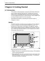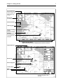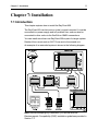
1
Distributed by
Any reference to Raytheon or
RTN in this manual should be
interpreted as Raymarine.
The names Raytheon and RTN
are owned by the
Raytheon Company.
ELECTRONIC CHARTING SYSTEM
OPERATION MANUAL
.12
N 43#34.944'
W 72#26.223'
N 43#34.944'
W 72#26.223'
RayChart 620
RayChart 620
RayChart 620
Electronic Charting System
Operation Manual
IMPORTANT NOTICE
This device is only an aid to navigation. Its accuracy can be
affected by many factors, including equipment failure or defects,
environmental conditions and improper handling or use.
It is the user’s responsibility to exercise common prudence and
navigational judgement, and this device should not be relied upon
as a substitute for such prudence and judgement.
RayChart 620
RAYTHEON MARINE ELECTRONICS products are supported by a
network of Authorized Service Representatives. For information on
Raytheon products and services, contact either of the following:
UNITED STATES
Raytheon Marine Company
676 Island Pond Road
Manchester, NH 03109-5420
Telephone: (603) 647-7530
800 539-5539
Fax: (603) 634-4756
EUROPE
Raytheon Marine Europe
Anchorage Park
Portsmouth
Hampshire PO3 5TD
England
Telephone: 01705 693611
Fax: 01705 694642
Copyright © Raytheon Marine Company 1997
The technical and graphical information contained in this handbook, to
the best of our knowledge, was correct as it went to press. However, the
Raytheon policy of continuous improvement and updating may change
product specifications without prior notice. Therefore, unavoidable
differences between the product and handbook may occur from time to
time, for which liability cannot be accepted by Raytheon.
Raytheon is a registered trademark of Raytheon Company
SeaTalk is a registered trademark of Raytheon Marine Europe Limited
RayChart is a trademark of Raytheon Marine Company
C-MAP is a registered trademark.
Preface
i
Preface
This handbook covers the RayChart 620 electronic charting system
from Raytheon. It contains very important information on the installation
and operation of your new equipment. In order to obtain the best results
in operation and performance, please read this handbook thoroughly.
Raytheon Product Support or your local dealer will be available to
answer any questions you may have.
How this Handbook is Organized
This handbook is divided into the following chapters:
Chapter 1: Introduces the RayChart 620’s features and concepts.
Chapter 2: Explains how start using the RayChart 620, including
instructions for turning it on, using the controls, changing the lighting,
and using chart cards. Simple exercises are also included.
Chapter 3: Provides instructions for controlling the chart (including
moving the chart and changing the chart scale), and using the default
soft keys to set up and use on-screen routes.
Chapter 4: Explains how to use additional basic functions, such as
track histories, marks and events, and how to display navigational data.
It also explains how to use the MOB function.
Chapter 5: Provides information on the stored data, such as waypoints,
routes and events, and how you can review, edit and use it.
Chapter 6: Provides instructions for customizing the RayChart 620
defaults, such as the numerical units used, the equipment connected
and the alarm settings, to suit your preferences. It also explains how to
customize the screen display.
Chapter 7: Provides instructions for installing the RayChart 620.
Chapter 8: Provides information on maintenance, and what to do if you
experience problems with your RayChart 620.
Appendix A: Provides information on the data sources and standards,
together with information on data output.
Appendix B: Lists the system specifications.
A glossary, index and warranty information are included at the end of
the handbook.
RayChart 620
ii
How to Use this Handbook
This handbook is organized with the information about operating the
RayChart 620 at the front, since you will probably use these chapters
most often.
When you first receive your RayChart 620, you should read Chapter 7,
and install the equipment. Then read Chapter 2, and familiarize yourself
with the controls of the RayChart 620. You may also wish to read
Chapters 3, 4 and 5.
When you are happy with the basics of using the RayChart 620, read
Chapter 6, decide how you wish to set up your defaults, alarms and the
screen, and follow the instructions to make your changes.
Once you are on the water, you can follow the instructions in Chapters 3
and 4 to perform all your routine tasks, and refer to Chapter 5 for
information about more advanced features.
If you experience any difficulties with your RayChart 620, refer to
Chapter 8.
Note: The Quick Reference Card, included with your system, provides
a useful summary of the RayChart controls.
Warranty
To verify your RayChart 620 ownership, please take a few minutes to fill
out the warranty registration card found at the end of this handbook. It is
very important that you complete the owner information and return the
card to the factory in order to receive full warranty benefits.
EMC Conformance
All Raytheon equipment and accessories are designed to the best
industry standards for use in the leisure marine environment.
Their design and manufacture conforms to the appropriate
Electromagnetic Compatibility (EMC) standards, but good installation is
required to ensure that performance is not compromised.
Contents
iii
Contents
Chapter 1: Introduction ......................................................... 1
1.1 Overview ........................................................................... 1
1.2 RayChart 620 Features...................................................... 1
1.3 Navigational Displays ........................................................ 2
Chapter 2: Getting Started .................................................... 3
2.1 Introduction ....................................................................... 3
Basics ............................................................................... 3
Text Conventions .............................................................. 4
2.2 Turning the RayChart On and Off ....................................... 4
2.3 The Chart Display .............................................................. 6
2.4 Using the RayChart Controls .............................................. 8
The Trackpad .................................................................... 8
The Soft Keys .................................................................... 8
Soft Key Default Functions .......................................... 10
Other Soft Key Functions ............................................ 11
2.5 djusting the Lighting and Contrast ..................................... 11
2.6 Using Chart Cards ........................................................... 12
Inserting a Chart Card ...................................................... 12
Removing a Chart Card ................................................... 13
Chapter 3: Controlling the Chart and Using the Default
Soft Keys ............................................................................ 15
3.1 Introduction ..................................................................... 15
3.2 Controlling the Chart ........................................................ 16
Moving the Chart ............................................................. 16
Changing the Chart Scale ................................................ 17
Centering the Chart and Using Home Mode ...................... 18
Centering the Chart ..................................................... 18
Using Home Mode ...................................................... 19
iv
RayChart 620
Displaying Information About Objects ............................... 20
3.3 Using the GO TO Key ...................................................... 21
Tracking to a Target Point ................................................ 21
Editing the Waypoint Details ............................................. 22
Clearing or Changing a GO TO ........................................ 22
3.4 Setting Up and Using On-Screen Routes .......................... 23
Making a New On-Screen Route ...................................... 24
Editing an Existing Route On-Screen ................................ 26
Editing Route Information ................................................. 27
Using a Route ................................................................. 29
Following, Reversing and Stopping a Route ................. 29
Advancing to the Next Leg of the Route ........................ 30
Erasing a Route .......................................................... 30
3.5 Measuring Distances Using the RULER Key ..................... 31
Chapter 4: Additional Basic Functions ............................... 33
4.1 Introduction ..................................................................... 33
4.2 Marks and Events ............................................................ 34
Placing and Deleting a Mark ............................................. 34
Placing and Deleting an Event .......................................... 35
4.3 Using Track Histories ....................................................... 36
Starting and Stopping a Track .......................................... 36
Deleting the Current Track ............................................... 37
Editing Track Controls ...................................................... 37
4.4 Displaying Navigation Information, Using DISPLAY ........... 39
Chart .............................................................................. 39
Changing between Full Screen and Windows .............. 40
Changing the Window Setup ....................................... 40
Navigation ....................................................................... 42
4.5 Man Overboard (MOB) .................................................... 43
4.6 Alarms and Timers ........................................................... 44
Contents
v
Chapter 5: Using Stored Lists (EDIT) .................................. 45
5.1 Introduction ..................................................................... 45
5.2 The Waypoint List ............................................................ 46
Viewing the Waypoint List ................................................ 46
Waypoint List Operations ................................................. 47
Finding a Waypoint in the List ...................................... 47
Editing a Waypoint or Adding a New Waypoint ............. 48
5.3 The Current Route ........................................................... 49
Viewing the Current Route ............................................... 49
Current Route Operations ................................................ 50
5.4 The Route List ................................................................. 51
Viewing the Route List ..................................................... 51
Route List Operations ...................................................... 52
Route Details................................................................... 53
Editing a Route or Building a New Route ........................... 54
5.5 Finding and Displaying a Waypoint ................................... 55
5.6 Displaying and Printing the Log ........................................ 56
5.7 Printing ........................................................................... 56
Chapter 6: Customizing the RayChart ................................ 57
6.1 Introduction ..................................................................... 57
6.2 Setting Up the Data.......................................................... 58
Setting the Defaults ......................................................... 58
Setting Up the System ..................................................... 59
Input Selection ............................................................ 60
Units .......................................................................... 61
Language ................................................................... 61
Printer Baud Rate ....................................................... 61
Date and Time ............................................................ 61
Head Up Response .................................................... 62
vi
RayChart 620
Simulator .................................................................... 62
Keypress Sound ......................................................... 62
Help ........................................................................... 62
Setting Up the Navigation Data ......................................... 63
Heading ..................................................................... 63
Magnetic Variation ...................................................... 63
Position Resolution ..................................................... 64
TD Settings Menu ....................................................... 64
Map Datum and Fix Datum .......................................... 64
Position Correction ...................................................... 64
Setting Up the Chart Plotter .............................................. 64
Waypoint Name .......................................................... 65
Waypoint Display ........................................................ 65
Course Vector ............................................................ 65
Heading Vector ........................................................... 66
Wind Vector ................................................................ 66
Tide Vector ................................................................. 66
Dead Reckoning ......................................................... 66
Cursor Data Box ......................................................... 66
Setting Up the Alarms and Timers .................................... 67
Alarms ........................................................................ 67
Timers ........................................................................ 68
Fix Status ........................................................................ 68
Memory C-Card ............................................................... 69
6.3 Customizing the Screen Display ....................................... 71
Setting the Cartography Detail .......................................... 71
Chart Orientation ............................................................. 73
Setting Up Windows ........................................................ 74
Contents
vii
Chapter 7: Installation ......................................................... 77
7.1 Introduction ..................................................................... 77
7.2 Packing List ..................................................................... 78
7.3 Planning the Installation ................................................... 78
Selecting a Location ........................................................ 79
Connection Options ......................................................... 80
Cabling ........................................................................... 81
EMC Installation Guidelines ............................................. 82
7.4 Mounting the RayChart .................................................... 83
Trunnion Mounting .......................................................... 83
Panel Mounting ............................................................... 83
7.5 RayChart Connections..................................................... 84
Power and I/O Connection ............................................... 85
DC Power ................................................................... 85
NMEA Connection ...................................................... 86
Printer Connection ...................................................... 86
GPS Connection ............................................................. 86
SeaTalk Connection ........................................................ 87
7.6 System Check and Initial Setup ........................................ 87
System Check ................................................................. 87
Switch On and Initial Setup............................................... 88
EMC Checks Before Going to Sea .................................... 88
Chapter 8: Maintenance and Problem Solving .................... 89
8.1 Routine Maintenance ...................................................... 89
Cabling and Connections ................................................. 89
EMC Servicing and Safety Guidelines .............................. 89
Advice............................................................................. 89
8.2 Problem Solving .............................................................. 90
8.3 Unit Test and Reset ......................................................... 90
viii
RayChart 620
Appendix A: Data Input and Output .................................... 93
A.1 Data Standards ............................................................... 93
SeaTalk .......................................................................... 93
NMEA ............................................................................. 93
A.2 SeaTalk or NMEA Data Input and Output ......................... 94
A.3 Loran GRIs ..................................................................... 95
Appendix B: Specification .................................................. 97
Glossary ............................................................................. 99
G.1 Terms ............................................................................ 99
G.2 Abbreviations ............................................................... 100
Index ................................................................................. 103
Chapter 1: Introduction
1
Chapter 1: Introduction
1.1 Overview
The RayChart 620 is a sophisticated electronic charting system, which
uses GPS, dGPS or Loran-C technology to make navigation as simple
and accurate as possible.
The RayChart displays chart information from the C-MAP NT® range of
electronic chart cards (C-Cards), and position information from satellites
or land-based radio beacons. It can also display virtually any data
available from other compatible instruments in your system.
The RayChart is designed to be extremely easy to use, while providing
powerful options for handling data and customizing the system to
match your requirements. Everyday functions are available at the touch
of a button, with as much or as little help as you need. The on-screen
prompt and menu system, from which you can select the functions and
options you require, simplifies even complex tasks such as editing
stored route data.
The display unit can be installed either above or below deck, and can
be illuminated for night-time use.
1.2 RayChart 620 Features
The RayChart 620 provides the following features and functions:
• Chart display with zoom and pan control; a background world map is
included, and there are two slots for inserting C-MAP NT C-Cards for
large-scale cartography
• Vessel’s position displayed, with optional heading, course, tide and
wind vectors, and optional track history display
• Quick and easy on-screen route setup and control
• “Go To” function for marking a waypoint and tracking towards it
immediately
• Event and mark recording
• Edit and review functions for stored route, waypoint and event data
• Display options controlling the cartographic data displayed, and
windows for displaying selected navigational data repeated from
other instruments
2
RayChart 620
• Setup options to allow you to customize the RayChart according to
your own system and preference, such as chart orientation (north up,
course up or head up), display windows, and alarm setup
• Ruler function for measuring chart distances
• Centre options for centering the chart on the ship, cursor, or a
specified position, and a Home Mode for displaying the vessel’s
current position and tracking information
• Alarm reporting and control, and a range of timers including
countdown and elapsed timers
• Log record
• Plotter mode can be selected, which allows the use of the RayChart
at ranges for which no chart information is available
• 7 languages
• Print option
• Memory C-cards can be used to store and transfer route, waypoint,
event and track history data
• If two RayCharts are installed on the system, each can be operated
independently, but the active route is displayed on both units
1.3 Navigational Displays
Because the RayChart is compatible with the SeaTalk® and NMEA
0183 standards, it can be set up to display data sent by other
instruments, such as a RayData or RayPilot.
You can customize the display to include a range of data sets, selected
from the data available over either a SeaTalk bus or an NMEA
connection. In addition to repeating data from other instruments, the
RayChart calculates extra items from received data.
The RayChart can also display a Course Deviation Indicator (CDI) or
Bearing Deviation Indicator (BDI) window, showing the deviation from
the required course or bearing in a graphical display.
Chapter 2: Getting Started
3
Chapter 2: Getting Started
2.1 Introduction
This chapter provides information, instructions and simple exercises to
get you started using the RayChart 620. It will help you to become
familiar with the chart display and the functions of the controls before
you start using the RayChart for routine navigation. It also explains how
to change the lighting and how to use chart cards.
More detailed information on operating the RayChart is given in
Chapters 3, 4 and 5.
Basics
The RayChart 620 is controlled using a trackpad and 12 keys. Eight of
the keys are labelled, and are dedicated to specific functions. The
remaining four, at the bottom of the display, are “soft” keys, and are
used to perform different functions in different circumstances. The soft
key functions are indicated by labels or menus displayed at the bottom
of the screen, above each key.
Some keys can be used in two ways:
• Press: Press the key momentarily and then release it. This method is
used for most key operations.
• Press and hold: Press the key and hold it down for the length of time
stated (for example, 3 seconds), and then release it. This method is
only used in special circumstances.
4
RayChart 620
As you press a key, a single audio beep confirms the key action. If the
key-press is not valid for the current screen or mode, three rapid beeps
sound to indicate that no response is available. If required, you can turn
the key beeps off as part of your setup procedure (see Chapter 6).
The RayChart 620 includes pop up help to assist you when you start
using the system. When you press a key to perform a task, a prompt is
displayed that provides additional information or instructions. Once you
are familiar with the keys and the way they work, you can switch off the
help to leave the chart display clear.
Text Conventions
Throughout this handbook, the dedicated (labelled) keys are shown in
bold capitals; for example, MENU. The soft (unlabeled) key functions,
menus and options are shown in normal capitals; for example, ROUTE.
Operating procedures, which may consist of a single key-press or a
sequence of numbered steps, are indicated by the ➤ symbol in the
margin.
The short exercises in this chapter are shown in italic type, like this
paragraph.
Terms included in the glossary are shown in bold type.
2.2 Turning the RayChart On and Off
➤ To turn the RayChart on and start operation:
1. Press and release the red POWER key.
The keys light up, and the display shows the last-used chart. Over
this is the RayChart status screen, which includes:
-
Software version number
-
Database version number
-
Card number and description for each of the two card slots, if in
use
After 10 seconds, a notice is displayed reminding you that the
RayChart is only an aid to navigation, and should be used with
appropriate prudence and judgement.
Note: You can now turn on and adjust the display backlighting and
contrast, if required, as described later in this chapter (see
Section 2.5).
Chapter 2: Getting Started
5
2. When you have read the notice, press the soft key below the
CONTINUE label to clear it.
The Fix Status window is displayed, as shown in the following
example for a GPS position fixer.
D3838-1
The right side of the window shows a representation of the satellite
positions, with each satellite identified by a number. The bargraphs
on the left indicate the signal strength for each of the currently
located satellites. Initially, the RayChart uses the predicted satellite
positions, and the bargraphs are blank until the satellites are
located.
The RayChart searches for the strongest signals: at least four are
required for an accurate position fix. If the signals from the currently
located satellites are not strong enough, the RayChart searches for
other satellites and displays these in turn.
Once a position fix has been established, the chart is displayed, as
described on the following pages.
3. If you do not wish to wait for the position fix, you can clear the search
graphics and display the chart by pressing the key below the
CHART label. (You can redisplay the Fix Status window later if
required, as described in Chapter 6.)
A “Fix Alarm” message is displayed, that you can clear by pressing
any key. The unit will beep every few seconds to indicate that there
is no position fix, until the position has been established.
6
RayChart 620
4. Alternatively, press the key below the INITIALIZE label to access
the setup pages (see Chapter 6).
➤ To turn the RayChart off, press and hold the POWER key for three
seconds. A countdown timer is displayed, and if you release the key
before the timer reaches zero the RayChart will remain on. Otherwise,
when the timer reaches zero the RayChart display is cleared and the
key lights go off.
2.3 The Chart Display
Once the position fix has been established, the screen shows the chart
area and associated data that were displayed when the RayChart was
last used. If this is the first time it has been turned on, and no chart card
is installed, the display shows the small-scale chart at 0°/0°, and the
default soft key labels.
An example RayChart chart display, in its default configuration but with
a chart card installed, is shown in the top illustration opposite.
The cursor data box normally provides the following information:
• The cursor position, in either latitude and longitude or TDs,
depending on your setup
• The vessel’s Course Over Ground (COG) and Speed Over Ground
(SOG)
• A mileage scale ruler in nautical miles
• The cursor’s bearing (BRG) and range (RNG) from your vessel’s
current position
The cursor data box is also used to display the vessel’s position and the
range and bearing to the active waypoint, when the RayChart is in
Home Mode (see Section 3.2).
Note: If required, you can use the setup options to change the units in
which information is displayed, turn off the cursor data box and soft key
labels, and change the chart orientation (see Chapter 6).
The chart display can show additional information, depending on the
current data and on your setup selections, as shown in the example
RayChart display in the bottom illustration opposite.
Chapter 2: Getting Started
7
Cursor data box
Shows the current
cursor position as
either Lat/Long
or TDs
Scale rule,
in nautical miles
Chart boundary
Lat/Long grid
Vessel's heading
vector
Vessel's current
position
Cursor position,
controlled by the
trackpad
✣
Default soft key labels
These can be turned off. To redisplay them, press any soft key.
Object data box
Route leg
✣
Active waypoint
Track history
Mark
Event
Customizable Window,
showing navigation data
and CDI
D3819-1
8
RayChart 620
2.4 Using the RayChart Controls
The RayChart controls are summarized in the illustration on the
following fold-out page. The remainder of this section considers the
trackpad and soft keys in more detail, and provides some simple
exercises for you to try.
The Trackpad
The trackpad is used to move the cursor on the chart and around the
on-screen menu displays. The cursor is the cross symbol (✣) that is
visible on the chart.
You can push on any of the four dots on the trackpad, or midway
between two dots, to move the cursor in that direction. If you press and
hold down the trackpad, the cursor moves faster.
➤ Try using the trackpad now to move the cursor around the chart. You
can use short presses on the trackpad to move the cursor small
distances, or press and hold to move the cursor quickly.
As you move the cursor to the edge of the display, the display pans
across the chart so that the area you have moved to remains in view. If
you continue to scroll, the chart is redrawn on the screen at intervals.
If you move the cursor over an object for which there is information
available, an Object Data Box appears at the top of the screen (see
Chapter 3).
The trackpad is also used to edit information and move around menus,
as described in Chapter 6.
The Soft Keys
The four soft keys are called “soft” because they can have completely
different functions when you select different modes of operation. This is
why the keys do not have labels printed on them. Instead, the labels for
the current functions are displayed on the screen immediately above
the keys.
You can control whether or not the soft key labels are displayed all the
time, using the system set up as described in Chapter 6. If no labels are
displayed, press one of the soft keys to make them appear. The labels
disappear again if you do not press a key for 7 seconds.
Chapter 2: Getting Started
9
DISPLAY
Press to display current main screen mode.
Press to toggle the main screen modes, and use the soft keys to
select the required window or a full-screen display.
The display times out to the normal display.
MARK
Press to display Mark soft keys
Choose Mark symbol.
Press PLACE MARK to place the mark symbol at the cursor position.
Press EXIT to finish.
Press and hold for 5 seconds to print the current display
MOB
Press and hold for 2 seconds to activate or cancel Man Overboard.
EVENT
Press to display Event soft keys
Choose Event symbol.
Press PLACE EVENT to place event symbol at the vessel's position.
Press EXIT to finish.
Chart range scale control
Press the top of the key to zoom out to a smaller-scale chart.
Press the bottom of the key to zoom in to a larger-scale chart.
Press and hold to change the scale faster.
PLACE EVENT
SELECT SYMBOL
DELETE EVENT
EXIT
PLACE EVENT
SELECT SYMBOL
DELETE EVENT
EXIT
Trackpad
Press the edge to move the cursor on the chart or in the menus.
Press and hold to move the cursor moves faster.
ENTER
Press to confirm a selection and (if appropriate) clear the current
soft key labels. The key either performs the selected task,
accepts changes, or leads to a display of further options.
CLEAR
Press to cancel an operation or display, and return to the previous
display.
MENU
Press to display the Main Menus, with the last-used option
highlighted. Use the soft keys or trackpad to highlight the required
option, and press ENTER.
Press CLEAR to finish.
POWER
Press to turn on the display.
Press to access lighting control.
Press for 3 seconds to turn off
the display.
Soft keys
Press to select the indicated function, or scroll round a menu list.
If no labels are displayed, press any soft key to display the default
soft key labels.
Labels change when you press a dedicated key, as
shown above the keys.
D3350-1
10
RayChart 620
Soft Key Default Functions
In default mode, the soft keys provide a quick method of performing
the tasks you will probably use most often, and which are described in
detail in Chapter 3.
D3352-2
You use the soft keys to access the following functions:
ROUTE
Set up or edit an on-screen route of waypoints, and
navigate towards them in turn
GO TO
Navigate towards a location you have indicated with the
cursor
RULER
Measure distances and bearings on the chart
CENTER
Center the chart on the cursor, vessel or a specified
position, or select Home Mode
If different labels are displayed on the screen, press the CLEAR key to
select the default functions.
Note that, when you press a soft key, the action depends on the
function type. It can have the following effects:
• Perform the action immediately; for example, the GO TO soft key
• Display a menu of further options; for example, the ROUTE soft key
• Reassign the soft keys and display new soft key labels; for example,
the CENTER and RULER keys
➤ Try using the CENTER key to center the chart on the cursor position:
1. Move the cursor to one side of the chart.
2. Press the CENTER soft key.
New soft key labels appear above the keys.
D3351-1
3. Press the CENTER CURSOR soft key.
The cursor and its current chart location both move to the center of
the screen.
4. Press CLEAR to leave the option and return to the default screen,
with the new chart position.
Chapter 2: Getting Started
11
Other Soft Key Functions
In addition, the soft keys provide access to different functions that you
will probably use less often. If you press the MENU, EVENT, MARK,
DISPLAY or POWER dedicated keys, the labels on the soft keys
change to allow you to use these other functions, as shown in the
illustration on page 9. Press CLEAR to return to the default display.
2.5 Adjusting the Lighting and Contrast
You can change level of lighting and contrast for the screen. There are
six brightness levels, and 40 contrast levels.
➤ To change the backlighting and contrast:
1. Press the POWER key. (Do not press and hold the key, or the
power-off message will be displayed.)
Two sliders appear on the screen, showing the current settings for
brightness and contrast, and the soft key labels are updated to
provide control of the sliders.
D3820-1
2. Press the appropriate soft key, to adjust the backlighting brightness
or the contrast to the required level. The brightness and contrast
change as you adjust the sliders.
3. Press ENTER to store the new settings and clear the soft keys and
graphical display.
Alternatively, you can press CLEAR to exit without making the
changes.
The screen returns to the standard display.
The new lighting and contrast levels are retained until you reset them or
turn off the RayChart. At power-on, the screen lighting is always off, but
the last-used contrast setting is retained.
The key lighting is bright when the screen backlighting is on. Even when
the screen lighting is off, the keys are lit at a low level (which is not
visible in daylight), so that you will always to able to find the keys.
12
RayChart 620
2.6 Using Chart Cards
The RayChart has a built-in world map. Most areas are covered on a
scale of about 500nm per inch on the screen (200nm per cm), although
some populated areas have details down to 20nm or even 10nm per
inch on the screen. The RayChart displays a scale indicator on the
screen for all chart displays.
For safer navigation, you will need to use larger scale charts with
detailed information. These are available using C-MAP NT electronic
chart cards (C-Cards), each of which can store as many as 20 charts in
an electronic format. A C-MAP chart normally provides as much
information as is available in paper charts for that geographic area, with
detail up to 0.05nm per inch.
The RayChart allows you to install two chart cards at the same time, if
required. You can also use the slots for C-MAP Memory C-Cards, which
allow you to store and retrieve data such as waypoints and routes.
Note: You can insert and remove cards while a chart is displayed. The
previous information is retained until the RayChart redraws the screen:
for example, it will do this if you scroll some way outside the current
area, or use the RANGE key to change the chart scale.
Inserting a Chart Card
➤ To insert a chart card:
1. Check that the card is the correct format (C-MAP NT C-Card), with
the required chart stored on it.
2. Open the card cover, at the top left of the RayChart front panel, by
pushing the latch to the left and then opening the cover as shown in
the illustration on the following page.
3. Hold the card with the printed text pointing towards the right and the
correct way up, as shown in the illustration.
4. Gently push the card into one of the two sockets. It will only go in if it
is the right way round.
Push the card in as far as it will go, then move it to the left so that the
top is under the retaining pegs. Release the card so that it is held in
place by the pegs.
5. Close the card cover so that is clicks shut, to stop water splashing
into the RayChart.
Chapter 2: Getting Started
13
6. The new chart information will be displayed when you move the
cursor into an area covered by the new chart or, if it is already in the
area, change the range scale.
Where appropriate, the boundary of each chart digitized in the
current card is shown as a box or rectangle. (You can turn of the
chart boundaries display if you wish, as part of the RayChart
customization.)
7. Use the trackpad to move the cursor inside one of the chart boxes,
and press the lower part of the RANGE key.
That area is expanded so that you can see more detail. Note that
the smaller the chart box is on the screen, the greater the amount of
detail that is available when you zoom in.
8. Unless you have turned on the Plotter Mode, you cannot zoom in
further than the most detailed chart, and you cannot zoom out
further than the world map.
Removing a Chart Card
➤ To remove a chart card:
1. Open the card cover, at the top left of the RayChart front panel, by
pushing the latch to the left (see above).
2. Press down the card you wish to remove, and move the top of the
card to the right to clear the retaining pegs.
14
RayChart 620
3. Pull out the card. It will pause half way out, due to a catch to prevent
it being ejected accidentally: you need to pull a little harder to pass
this point.
4. If required, insert a new card as described above. Remember to
close the card cover so that is clicks shut, to stop water splashing
into the RayChart.
15
Chapter 3: Controlling the Chart and Using the Default Soft Keys
Chapter 3: Controlling the Chart and
Using the Default Soft Keys
3.1 Introduction
This chapter explains how to perform some basic chart operations
using the trackpad, RANGE key, and the default soft keys. The default
soft key display is shown below.
D3352-2
Note: If you have set up your system so that the soft keys are not
displayed all the time (Help Level 0), press any soft key to display the
labels.
This chapter covers the following topics:
• Controlling the chart, including panning the chart (moving the area of
the chart displayed on the screen), changing the range scale,
centering the chart and displaying information about objects
• Using the GO TO key to navigate towards a selected point
• Setting up and using on-screen routes
• Measuring distances using the RULER key
Further basic functions, including track histories and placing marks and
events, are described in Chapter 4. More advanced operation, involving
the stored lists, is described in Chapter 5, including retrieving stored
routes and making new routes using stored waypoints.
Safety
The RayChart makes it very easy to mark a waypoint and track towards
it. However, you should always check first that the route is safe. If you
are using the RayChart in combination with a SeaTalk autopilot, the
autopilot will prompt for confirmation before it steers the vessel towards
the waypoint.
If you have entered your route using a small-scale chart, zoom in to a
larger scale to check for hazards, such as small shoals, that may not be
shown on the smaller scale.
16
RayChart 620
3.2 Controlling the Chart
This section covers the following topics:
• Moving the chart, so that a different area of the chart is displayed on
the screen
• Changing the chart scale using the RANGE key, and using the
display in Plotter Mode
• Centering the chart using the CENTER soft key, and using Home
Mode
• Displaying information about objects
Note: The orientation of your chart (North Up, Course Up or Head Up)
depends on your choice when you set up the RayChart, as described in
Chapter 6.
Moving the Chart
You will normally operate the RayChart 620 with the chart showing your
vessel’s current location. In the default North-Up orientation, the display
is in True Motion mode, in which the vessel moves across the screen.
You will need to move the chart if your vessel moves out of the area
currently displayed, or if you wish to examine or place marks/waypoints
in another area.
There are three ways in which you can move the chart:
• Use the trackpad to move the cursor to the edge of the chart. The
chart will pan across (see Chapter 2). This method is useful if the
area you wish to see is only just off the screen.
• Use the RANGE key to zoom out to a small scale chart, move the
cursor to the centre of the required area, then zoom in on the new
area (see page 17). This method is useful if the area you wish to see
is a long way away.
• Use the CENTER soft key to center the chart on one of a choice of
positions: the vessel’s position, the cursor position or a specified
position (see page 18).
Note: If you have selected a chart display with one or two data windows
(see Chapter 4), the RayChart will treat the start of the data window as
the edge of the chart.
Chapter 3: Controlling the Chart and Using the Default Soft Keys
17
Changing the Chart Scale
The RANGE key allows you to change the cartography scale so that
you can see a smaller or larger area on the screen. You can use it for
two purposes:
• To see either more detail (a smaller area) or a larger area on the
screen
• To move the display to another area of the chart, by zooming out to a
small scale chart, then zooming in on another area
Small scale charts give you the wider view, but without the level of detail
that you may need in order to navigate safely. The amount of detail that
is visible depends on the amount available for that chart, and also on
how you have specified the cartographic detail when you set up your
RayChart (see Chapter 6).
The RayChart 620 includes a small-scale chart of the world. When you
insert a chart card and (if necessary) scroll to the charted area, the
display shows the boundaries of the charts digitized in the current card.
➤ To zoom in to a larger scale chart:
1. Use the trackpad to position the cursor in the area you wish to see in
more detail.
2. Press the lower part of the RANGE key.
The section of the chart around the cursor is enlarged to fill the
screen with a larger-scale chart showing more detail. The cursor is
now positioned in the center of the screen.
The range scale indicated at the top left of the screen is updated.
Note: If you hold down the RANGE key, the range scale display is
updated quickly without the chart being redrawn. Simply release the
key when the required scale is shown, and the chart will then be
updated.
3. If further chart enlargement is available using the current chart card
you can press the bottom of the RANGE key to zoom in again,
repositioning the cursor first if required.
An area of further chart detail is indicated by a box around the area.
4. If no further chart detail is available, and you press the bottom of the
RANGE key again, the effect depends on whether you have set
Plotter Mode on or off when you set up the RayChart (see
Section 6.3):
18
RayChart 620
-
If Plotter Mode is off (the default setting), the RayChart will beep
three times and the range scale will not change.
-
If Plotter Mode is on, the range scale is increased and the
display shows grid lines and no cartography. The letter “P” is
displayed after the scale rule to indicate that the RayChart is in
Plotter Mode.
The cartographic information is restored when you return to a chart
scale for which the information is available.
➤ To zoom out to a smaller scale chart, simply press the upper part of the
RANGE key as many times as required. If no smaller scale chart is
available, then the RayChart beeps three times when you press the
upper part of the RANGE key.
Centering the Chart and Using Home Mode
You can move a chosen point to the center of the chart, using the
CENTER soft key. The chosen point can be the vessel’s position, the
cursor position or a specified position.
You can also select Home Mode, which centers the vessel, homes the
cursor and changes the cursor data box to provide information about
your vessel’s position.
Note: Changing the range scale always centers the chart on the cursor.
Centering the Chart
➤ To center the chart using the CENTER options:
1. From the default soft key display, press the CENTER soft key.
New soft key labels are displayed, as shown below.
D3351-1
2. Press the soft key for the center option you require (or CLEAR to
return to the default screen without change):
-
CENTER SHIP moves the chart so that your vessel’s position is
at the centre of the chart, and repositions the cursor so that it is
over the vessel
-
CENTER CURSOR moves the chart so that the point you
selected with the cursor is at the centre of the chart
-
REMOTE CENTER provides a box for you to enter the position
for the new center
Chapter 3: Controlling the Chart and Using the Default Soft Keys
-
19
HOME moves the chart so that your vessel’s position is at the
centre of the chart, and enters Home Mode (see below)
3. If you pressed REMOTE CENTER, the box displays the current
cursor position, as latitude and longitude or TDs depending on your
system.
D3821-1
Change the values to the required position, as follows:
a. Move the cursor to the first digit you wish to change, using the
left or right trackpad controls. When you move right from the
latitude direction, the cursor moves to the first longitude digit.
b. Increase or decrease the number, using the up or down
trackpad controls.
c. Repeat steps a and b until all the digits are set to the required
values.
d. Press ENTER to set the position.
4. The display returns to the CENTER soft keys display, with the new
chart position. Press CLEAR to return to the default display.
Using Home Mode
When you select the HOME option, the RayChart centres the vessel
and changes to Home Mode. In this mode:
• The cursor is not displayed, and is fixed to the vessel’s position
• The cursor data box displays the vessel’s current position; if you are
tracking to a waypoint, it also displays the waypoint name, bearing
and range
• In Head Up or Course Up modes (see Chapter 6), the display
changes to Relative Motion, in which the chart moves to keep the
vessel in the centre of the display.
➤ To return to the standard cursor and motion mode, press the trackpad.
The cursor reappears at the vessel’s current position, and the cursor
data box displays the cursor position data.
20
RayChart 620
Displaying Information About Objects
Chart cards include a number of displayed features for which
information is available, such as anchorage points. In addition, position
information is available for waypoints and events added using the
RayChart functions.
D3822-1
➤ To obtain the additional information:
1. Move the cursor over the object for which you require the
information.
After a moment, an Object Data Box appears at the top of the
screen, as shown at the top of the example above.
If the cursor is over more than one object for which information is
available, the number of objects is shown and their descriptions are
listed
2. Press ENTER. The soft key labels EXPAND and ALLINFO are
displayed.
3. To obtain expanded information about the object(s):
a. Press the EXPAND soft key. The objects and any sub-objects
are listed in a window in the center of the screen.
b. Use the trackpad to scroll up and down the list, and highlight the
required object or sub-object.
c. Press ENTER. Any available information is displayed.
Chapter 3: Controlling the Chart and Using the Default Soft Keys
21
If there is more than one page of information for the object, you
can page through it using the PAGE DN soft key, and go back to
the beginning using the RESTART soft key.
d. Press CLEAR to return to the expanded list, and select another
object if required.
e. Press CLEAR to clear the expanded information display, and
return to the EXPAND and ALLINFO soft key display.
4. To obtain all the information available at this location, press the
ALLINFO soft key.
The information is displayed in the same way as the expanded data,
but includes additional information such as the depth range and the
source of the data.
5. Press CLEAR to clear the detailed information display, and return to
the EXPAND and ALLINFO soft key display.
6. Press CLEAR to return to the default display.
3.3 Using the GO TO Key
The GO TO default soft key provides a quick method of navigating to a
target point. You can select any target point (which is then stored as a
new waypoint) or an existing waypoint.
Note: You can also search for a specific waypoint and track towards it
using the Waypoint List options (see Chapter 5).
Tracking to a Target Point
➤ To navigate to a target point:
1. Use the trackpad to position the cursor on the target point.
2. Press GO TO.
Unless you are already tracking to a waypoint (see below), the
RayChart saves the target point as a new waypoint and starts
tracking towards it. If your target point is an existing waypoint, its
position is used and a new waypoint is not created.
✣
D3823-1
22
RayChart 620
The waypoint is shown as a circle with a dot in the center, and is
connected to the vessel’s starting position with a dashed line. The
waypoint is given a default name of the format xxxWPT, where xxx
is the next available waypoint number.
3. Press the EDIT soft key, that is displayed for 7 seconds, if you wish
to change any of the waypoint information for the new waypoint:
Editing the Waypoint Details
You can change the new waypoint’s name, symbol and position.
➤ To edit the waypoint details:
1. Press the EDIT soft key that is displayed for 7 seconds after you
request the GO TO. A window such as the following is displayed:
D3825-1
2. Use the left or right sides of the trackpad to move the cursor to the
number, letter or symbol you wish to change. You can hold the
trackpad down to move quickly.
3. Use the top or bottom of the trackpad to increase or decrease the
number, or change the letter or symbol.
4. Repeat steps 2 and 3 until the required information is displayed.
5. Press ENTER to save the details.
Clearing or Changing a GO TO
If you are already tracking to a waypoint when you request a GO TO,
the RayChart displays the following message:
D3824-1
Chapter 3: Controlling the Chart and Using the Default Soft Keys
23
The active waypoint may be a previous GO TO, or it may be the current
waypoint in an active route.
➤ To change to the new waypoint (GO TO target point), press ENTER.
➤ To cancel the GO TO and continue tracking to the existing waypoint,
press CLEAR.
➤ To stop tracking to the active waypoint, press MENU.
Note: This means you can abandon a GO TO at any time by pressing
GO TO then MENU. If you turned off the waypoint display when you set
up your RayChart, the GO TO waypoint will disappear from the chart,
since only the active waypoint and the current route waypoints are
displayed (see Chapter 6).
3.4 Setting Up and Using On-Screen Routes
The ROUTE soft key provides a quick and easy method of setting up
(or selecting) and using a route.
Note: You can also create, edit and control routes using the EDIT menu
options, as described in Chapter 5.
The RayChart 620 can store up to 20 routes. When you want to create
a new route, you can either select an empty route slot, or select an
existing route and edit or erase the old route data. If you need to keep
more than 20 routes, you can save the information to a memory card
(see Chapter 6).
Note: If you have two RayCharts on your system, the current route
(active or selected) or GO TO on one RayChart is displayed as Route 0
on the other RayChart. It is therefore advisable to avoid using Route 0
when you create a route.
When you press the ROUTE soft key, a menu such as the following is
displayed:
D3826-1
Note: The route number selection defaults to the last-used route. If this
route is empty, only the Make / Edit menu option is displayed. For
Route 0, if the route is the active route from another RayChart, the
ERASE and REVERSE options are not displayed.
24
RayChart 620
The menu options are as follows:
MAKE / EDIT Used to set up a new route using the cursor. You can
also use this option edit an existing route, adding and
removing waypoints, and to edit route information such
as waypoint names and symbols.
ERASE
Used to clear the existing route from memory. This
deletes the route, but not its component waypoints.
FOLLOW
Used to start tracking to the first waypoint on the route.
or OFF
Used to stop tracking. This soft key is displayed instead
of FOLLOW when a route is already active.
REVERSE
Used to reverse the tracking order of the waypoints in
the route.
NEXT LEG
Used to proceed to the next leg of the route.
Making a New On-Screen Route
➤ Making a new route using the ROUTE soft key couldn’t be easier:
1. Move the cursor to the area in which you wish to make the route,
and select a suitable chart scale.
2. Press the ROUTE soft key to display the Route menu and the
current route.
Note: If the full list of ROUTE options is displayed, a route already
exists in the selected route slot. You can select ERASE to delete the
route (see page 30), or continue with this procedure to add
waypoints to the existing route, as described below.
3. If required, press the SELECT soft key to select an empty route slot.
4. Press ENTER to select the highlighted Make/Edit option.
The soft key labels change, as shown in the illustration below.
5. Use the trackpad to move the cursor to the position on the chart
where you want your first waypoint to be.
Note: You can position the cursor on an existing waypoint, if
required. This waypoint will be included in the route, and a new
waypoint will not be created.
6. Press the PLACE WPT soft key.
The waypoint appears on the screen at the current cursor position,
together with the waypoint number assigned by the RayChart.
25
Chapter 3: Controlling the Chart and Using the Default Soft Keys
The first waypoint of a new route has a circle round the waypoint
symbol, indicating that it will be the active waypoint if the route is
made active.
The cursor data box and object data box are updated to show the
waypoint number and position, as shown in the example below.
7. Move the cursor to the next waypoint position. A dotted line
connects the cursor to the last waypoint.
8. Press PLACE WPT again. The waypoint is placed and the dotted
line changes to a solid line.
Note: If you make a mistake, you can delete a wrongly-placed
waypoint or insert an additional one, as described below.
9. Repeat steps 7 and 8 until you have placed all your waypoints. You
can have up to 50 waypoints in a route.
✣
D3827-1
10. When you have entered all your waypoints, press ENTER or
CLEAR to clear the Make/Edit soft keys.
Your route is displayed on the screen, but is not active.
➤ To add waypoints to a route using an external device such as the
NavPlotter 100, use the MAKE /EDIT option as described above. You
can then add waypoints using either the cursor and the PLACE WPT
key, or using the external device. When an external waypoint is
received, the cursor is positioned on it and the chart is centered.
26
RayChart 620
Editing an Existing Route On-Screen
You can edit the current route, even if it is active. You do this using the
same screen you used for entering a new on-screen route.
➤ To add waypoints to the end of an existing route:
1. Press the ROUTE soft key to display the Route menu and the
current route selection.
2. If required, press the SELECT soft key to select a different route.
The Route menu shows the complete list of options when a route is
present, and the route is displayed on the chart if it is in the currently
displayed area.
3. Use the trackpad, or press the ROUTE soft key, to highlight the
MAKE/EDIT option, and press ENTER.
The cursor is connected to the last-placed waypoint with a dotted
line, ready to add further waypoints to the route in the same way as
for a new route.
You can now add, delete or insert waypoints, although you cannot
delete a waypoint if you are tracking towards it.
Note: You can also use this option to delete waypoints that are not part
of the current route, if you have selected the waypoint display option
when you set up your RayChart (see Chapter 6).
➤ To delete a waypoint:
1. Use the trackpad to position the cursor over the waypoint you wish
to delete, until the data for that waypoint is displayed in the object
data box.
2. Press the DELETE WPT soft key.
3. Press ENTER to confirm the deletion, if the waypoint is used in a
route.
The waypoint disappears from the screen. If the waypoint was not
at the end of the route, then the waypoints before and after the
deleted waypoint are connected with a straight line.
➤ To insert an additional waypoint in a route:
1. Position the cursor on (or close to) the line between two existing
waypoints.
Chapter 3: Controlling the Chart and Using the Default Soft Keys
27
2. Press the ADD WPT soft key. The line changes from a solid line to a
dotted line. (If the RayChart beeps instead, move the cursor closer
to the line and press ADD WPT again.)
3. Move the cursor to the required position. Dotted lines connect the
cursor to the two existing waypoints.
4. Press ENTER. The new waypoint is placed, and named with the
first available waypoint number.
Editing Route Information
Once you have created a route, you can edit the route information,
including the route name and the waypoint names, symbols and
positions.
➤ To edit the route information for the currently selected route:
1. Press the EDIT soft key from the MAKE/EDIT screen of the ROUTE
menu.
A summary of the current route is displayed on the screen, and the
soft key labels change, as shown in the following example.
The route name is shown at the top of the route summary. For each
waypoint you placed, the following information is given:
28
RayChart 620
Leg
The leg number
Position
The position of the waypoint for this leg, as selected
by the cursor position when you made the route.
The position is given as either latitude and longitude
or TDs, depending on your setup selection.
WPT Name
The waypoint name. The default name is in the
format xxxWPT, where xxx is the waypoint number.
You can give the waypoint a name of up to 16
characters, which can be letters and/or numbers.
Depending on your setup selection, the full name or
only the first 3 or the first 6 characters may be
displayed on the chart.
Waypoints are listed in the Waypoint List in
alphanumeric order of name (see Chapter 4). If you
plan to use the Waypoint List, you may wish to
name related waypoints so that they are grouped
together in the list.
Sym
The waypoint symbol. The default is a circle, but you
can change it to any of the mark/event symbols (see
page 35).
Source
The source of the position information. For onscreen routes, this is always the cursor. If you edit
the position, the source is updated to “EDIT”.
You can change the route name or the waypoint positions, names
or symbols.
2. Use the left or right sides of trackpad to move the cursor to the
number, letter or symbol you wish to change. You can hold the
trackpad down to move quickly, or press ENTER to skip to the start
of the next field.
3. Use the top or bottom of the trackpad to increase or decrease the
number, or change the letter or symbol.
4. Repeat steps 2 and 3 until the required information is displayed.
5. When you have finished editing the data, you can either:
•
or
Press the SAVE & EXIT soft key to save the changes and return
to the default screen
Chapter 3: Controlling the Chart and Using the Default Soft Keys
•
29
Press the SAVE & FOLLOW soft key to save the changes,
return to the default screen, and start navigating towards the first
waypoint.
Using a Route
Once you have set up or selected a route, you can perform the
following tasks:
• Follow or “initiate” the route (that is, start tracking towards the first
waypoint)
• Retrace a route by following it in reverse order
• Advance to the next leg of the route
• Erase the route
You can also edit the route, even if it is active, as described above.
Note: If you have two RayCharts on your system, the active route on
one unit is also displayed on the second unit, where it will always
appear as Route 00. You can use the Route menu options on the
second unit to control the route tracking on the first unit.
Following, Reversing and Stopping a Route
Once you have set up a route, you can start navigating towards the first
waypoint or, if you are retracing the route, the last waypoint.
➤ If you did not initiate the route using the SAVE & FOLLOW soft key from
MAKE/EDIT, you can do as follows:
1. If the Route menu is not already displayed, press the ROUTE soft
key to display it.
2. If the required route is not displayed, press SELECT until the route
is displayed.
3. Check the route display to confirm which waypoint will become
active: this waypoint is displayed on the screen with a circle round it.
If you wish to follow the route in the reverse order, use the trackpad
or the ROUTE soft key to highlight the REVERSE option, and press
ENTER. The circle moves to the waypoint at the opposite end of the
route.
4. Use the trackpad or the ROUTE soft key to highlight the FOLLOW
option, and press ENTER.
30
RayChart 620
The RayChart will start tracking towards the waypoint, unless a
waypoint is already active.
If you are already tracking to a waypoint (either by following a route
or using the GO TO option), a warning message is displayed (see
page 23).
➤ To stop following the current route, select the OFF option from the
ROUTE menu. This option replaces the FOLLOW option when the
route is already active.
Advancing to the Next Leg of the Route
When you reach the active waypoint, the RayChart will automatically
start tracking towards the next waypoint in the route.
If you have set the Arrival Alarm when you set up your system, the
alarm buzzer sounds and a message is displayed when you reach the
waypoint.
The alarm is cleared after 7 seconds. You can clear the alarm earlier by
pressing any key.
D3832-1
Note: If you are tracking to a single waypoint or to the last waypoint of
the route, you must arrive at the waypoint circle to trigger the alarm. For
intermediate waypoints in the route, the alarm is also triggered if you are
off-course and reach a line perpendicular to the track through the target
waypoint.
➤ You can also advance to the next leg even if you have not reached the
current waypoint. From the ROUTE menu, highlight the NEXT LEG
option and press ENTER. The RayChart will start tracking from the
vessel’s current position towards the next waypoint.
Erasing a Route
The RayChart can store up to 20 routes. If you have used all the route
slots and want to create a new route, you can erase a selected route.
Note: If required, you can store routes on a Memory C-Card for future
use, as described in Chapter 6, before deleting them from the
RayChart’s memory.
Chapter 3: Controlling the Chart and Using the Default Soft Keys
31
➤ To erase an existing route:
1. Press the ROUTE soft key to display the Route menu.
2. Press SELECT until the required route is displayed.
3. Use the trackpad or ROUTE soft key to highlight the ERASE option,
and press ENTER.
4. Press ENTER to confirm the deletion.
The route disappears from the screen, and the route soft keys are
cleared.
Note: If you have set the waypoint display on when you set up your
RayChart (see Chapter 6), the waypoints will still be displayed.
Otherwise, only the waypoints for the current route are displayed, so
the waypoints for the deleted route will disappear.
3.5 Measuring Distances Using the RULER Key
➤ You can obtain an accurate measurement of the distance between two
points by using the RULER soft key, as follows:
1. From the default soft key display, press the RULER soft key.
The soft key labels change, as shown in the example below.
2. Use the trackpad to move the cursor to the measurement start
point.
3. Press FROM. The start point is marked with an “F”.
4. Use the trackpad to move the cursor to the measurement end point.
A dotted line connects the From point to the cursor.
5. Press TO. The end point is marked with a “T”.
A dotted line connects the two points, and a ruler data box is
displayed.
32
RayChart 620
6. If required, repeat with further FROM and TO positions. The ruler
information is updated each time you select a new FROM or TO
location.
7. Press CLEAR or EXIT to clear the ruler display and return to the
default screen.
Chapter 4: Additional Basic Functions
33
Chapter 4: Additional Basic Functions
4.1 Introduction
This chapter explains how to use some further basic functions available
on the RayChart 620, using the dedicated keys and the menus.
To get the most out of your RayChart, you should have set up the basic
data and the customized the display, as described in Chapter 6. Once
you have explored the display possibilities, you may wish to return to
the customization and make further changes (see Section 6.3).
This chapter covers the following topics:
• Using marks and events
• Recording and displaying track histories
• Using the DISPLAY key to display navigation information that may
be available on your system
• Man Overboard (MOB)
• Controlling alarms and timers
34
RayChart 620
4.2 Marks and Events
The RayChart allows you to place symbols to record marks or events.
You have a choice of 16 symbols for each type.
Marks and events differ in the following ways:
• Marks are used to record features at the cursor position, such as
fishing buoys and anchorages. They are only graphical marks, and
you cannot edit them or add information.
The Danger Zone mark ( ) has an associated invisible “exclusion
zone” around it. You can specify the radius of the exclusion zone as
part of your setup procedure (see Section 6.2). If your vessel enters
this zone, an alarm will sound.
• Events are used to record features at your vessel’s current position,
such as a good fishing spot.
Events are special waypoints. The RayChart assigns a unique
identifier to each event, in the format xxxEV, where xxx is the next
available number. The events are stored in the waypoint list, and can
be recalled and edited later (see Chapter 5).
Up to 1000 marks can be displayed on the screen at one time, and up
to 1000 events or waypoints.
Placing and Deleting a Mark
➤ To place a mark symbol at the cursor position:
1. Press the MARK key.
The soft key labels change, as shown in the example on the
following page.
The current mark symbol is shown below the cursor data box at the
top left of the screen.
2. If you wish to choose a different symbol for your new mark, press
the SELECT SYMBOL soft key. The Mark Symbols dialogue box is
displayed in the centre of the screen.
3. Use the trackpad to move around the symbols until the required
symbol is highlighted, and press ENTER.
The dialogue box is removed, and the new symbol is displayed
under the cursor data box.
Chapter 4: Additional Basic Functions
35
D3829-1
4. Position the cursor at the point where you wish to place the mark.
5. Press the PLACE MARK soft key to place the new mark at the
cursor position.
6. Press EXIT or CLEAR to return to the default screen.
➤ To delete a mark:
1. Press the MARK key, to display the Mark soft key labels.
2. Position the cursor over the mark you wish to delete.
3. Press the DELETE MARK soft key to delete the mark.
4. Press EXIT or CLEAR to return to the default screen.
Placing and Deleting an Event
➤ The procedure for placing an event is the same as for placing a mark,
except that you use the EVENT key and the event is always placed at
the vessel’s position (which must be in view). The event is marked with
an event name in addition to the event symbol.
➤ The procedure for deleting an event is the same as for deleting a mark,
except that, since events are special waypoints, you are prompted to
confirm the deletion.
36
RayChart 620
4.3 Using Track Histories
The RayChart TRACKS function allows you to mark on the chart the
actual route that your vessel has followed, as if it had left a visible fixed
wake.
While the track is turned on, it is recorded in the RayChart’s memory,
and can be retrieved and displayed later if required. For example, you
may wish to display a previous track, and then use the Route option to
place waypoints along it that you can then track towards.
You can store up to 5000 track points in total, in up to 5 track files. The
RayChart issues a warning when 4000 points have been stored. The
track files can be stored in permanent memory or downloaded to a
Memory C-Card (see Chapter 6). Files can be retrieved for display at a
later date. Up to 5 track history files, including the current track, can be
displayed on screen at one time.
The length of track that can be displayed is limited by the frequency of
the track points. The more frequent the track points, the more accurate
the track recorded, but the more memory required. If you wish to display
and record a long track, you may need to increase the gap (interval)
between points. Otherwise, once the memory is full, track points will
start to disappear from the beginning of the track.
The RayChart allows you to specify the track interval, in terms of either
distance or time.
You can check the number of track points recorded for each track file,
by displaying the Tracks Edit window as described below.
Starting and Stopping a Track
➤ To start and stop a track:
1. From the default soft key display, press the MENU key to display the
main menus.
D3360-1
2. Use the trackpad or press the TRACKS soft key to highlight the
START option, and press ENTER.
Chapter 4: Additional Basic Functions
37
The option changes to STOP, indicating that Track History is turned
on, and the RayChart starts laying down track marks.
The track data is stored in the track file that is set as the current track
(see below).
3. If you wish to turn Track History off again, highlight the STOP option
and press ENTER.
4. Press CLEAR to clear the menus.
Deleting the Current Track
Deleting a track clears all the track history data from the selected file,
ready to use it for new data.
➤ To delete the current track:
1. From the default soft key display, press the MENU key to display the
main menus.
2. Use the trackpad or press the TRACKS soft key to highlight the
DELETE option, and press ENTER.
3. Press ENTER again to confirm the deletion.
The track data in the current track file is deleted.
If the track is currently active, the old data is cleared from the file and
the screen, but any new track history information is still stored in the
current file.
4. Press CLEAR to clear the menus.
Editing Track Controls
The EDIT option on the Tracks menu allows you to edit the controls for
the current track and also any other tracks stored in memory. You can:
• Select one or more track histories for display.
• Change the track file for the current track history data. If you do this
while the track history is switched on, the RayChart stops storing
track data to the original track file, and starts storing it in the new file.
• Change the track interval for the current track. You can select one of
the following intervals:
- 1, 5, 10 or 30 seconds
- 1, 3, 5, 10 or 30 minutes
- 0.1, 0.5 or 1.0 nm
38
RayChart 620
• Start or stop a track history, or delete a selected track. These options
perform the same functions as the START/STOP and DELETE
options from the TRACKS menu.
➤ To edit the controls:
1. From the default soft key display, press the MENU key to display the
main menus.
2. Use the trackpad or press the TRACKS soft key to highlight the
EDIT option, and press ENTER. The Track History screen is
displayed.
D3830-1
3. Use the trackpad sides to scroll around the fields, and the trackpad
top and bottom to change the settings.
You can toggle the Display option on or off for any track, change the
current track file number, and change the track interval for the
current track.
4. If required, press the START/STOP soft key to turn the current track
on or, if it is already on, to turn it off.
5. To delete a track, move to the Display field of the track you wish to
delete, and press the DELETE soft key. Press ENTER to confirm
the deletion.
6. Press ENTER to accept your selections and return to the default
display, with the new track settings.
Chapter 4: Additional Basic Functions
39
4.4 Displaying Navigation Information, Using DISPLAY
Although you can use your RayChart 620 with the whole screen
devoted to the chart, you also have the option of displaying a wide
range of navigational data.
This information is normally presented in one or two windows, with the
chart displayed in the rest of the screen.
The display type is controlled using the DISPLAY dedicated key. When
you press the DISPLAY key, the following prompt is displayed, with the
last-used option highlighted:
D3839-1
Press DISPLAY to toggle between the two settings with their
associated windows and soft key functions:
CHART
Displays the chart type you used last – full or window.
The soft keys allow you to choose between a full screen
chart, and one with the current window(s) configuration.
In windowed mode, you can also change the window
set up.
NAV
Displays the chart and switches on the last-used
navigation steering insert to the bottom right of the
screen.
The soft key labels disappear after 7 seconds if you do not make a
selection.
The different display options are described in more detail in the
following sections.
Chart
The Chart display soft keys allow you to select either a full screen or one
with one or two windows. When you use the DISPLAY key to select the
chart, the display you used last (full or windowed) is shown.
The windows that are available for display include those you have
customized as part of your setup procedure, as described in
Section 6.3.
40
RayChart 620
Changing between Full Screen and Windows
➤ You can change between a full screen display and windowed display
using the soft keys, as follows:
FULL
Clears any data windows and soft keys and uses
the full screen for the chart display. The default
soft key labels are displayed, if requested in your
setup selection (see Chapter 6).
WINDOW
Displays the chart together with navigational data,
in the current default windows configuration.
WINDOW SETUP
This soft key is shown if a window is already
displayed. It allows you to change the window
configuration, as described below.
The soft key labels disappear after seven seconds if you do not make a
selection.
If you wish to change the display again, press DISPLAY. The soft key
labels are redisplayed.
Changing the Window Setup
The WINDOW SETUP soft key allows you to change the default
windows configuration. You can select:
• The number of windows (1 or 2)
• The position of the windows on the screen
• The contents of the windows, by selecting from the list of predefined
or customized windows available
Note: If the help level is set to Level 1 (the factory setting), the windows
are moved up the screen so that they do not overlap the default soft key
labels. This means that you cannot select two windows in a full-height
column: if you wish to do so, you must change the help setting to
Level 0, as described in Chapter 6.
➤ To change the default window configuration:
1. Press DISPLAY to display the Chart soft keys (see above).
2. If a window is not already displayed, press the WINDOW soft key to
display the WINDOW SETUP soft key.
Chapter 4: Additional Basic Functions
41
3. Press the WINDOW SETUP soft key to display the selection keys
and current settings, as shown in the following example.
D3833-1
4. Use the two left-hand soft keys to select the number and location of
the windows. You can select:
-
One window at the bottom left of the chart display
-
One window at the bottom right of the chart display
-
Two windows, one above the other, in a full-height column at the
right of the chart display
The display changes as you highlight the different settings.
5. Use the SELECT LEFT WINDOW or SELECT RIGHT WINDOW
soft key to select the data set for the window.
Each time you press a SELECT WINDOW soft key, the next
available set of data is displayed in the current window. These sets
include the six default windows supplied with your RayChart, plus
the four custom windows you can set up as part of your display
setup procedure (see Chapter 6).
6. When you are happy with your selections, press ENTER to return to
the Display Selection screen. This times out to the chart display with
the new window selection.
Alternatively, press CLEAR to cancel your selections and retain the
previous default configuration.
42
RayChart 620
Navigation
The Navigation display soft keys allow you to select a chart display with
either of the following:
• CDI, the Course Deviation Indicator, which shows off-course error as
the distance your vessel is from the current track
• BDI, the Bearing Deviation Indicator, which shows off-course error as
the difference between your vessel’s heading and the bearing to
waypoint
When you use the DISPLAY key to select the navigation display, the
indicator you used last (CDI or BDI) is shown.
The soft key labels disappear after 7 seconds if you do not make a
selection.
The CDI or BDI data is presented in a window at the bottom right of the
screen, together with steering data, as shown in the examples below:
CDI (Course Deviation Indicator)
Waypoint graphic, fixed until within 3nm
then moves down the screen
Rolling range lines at 1nm intervals
Vessel graphic
On-course indicator or direction to steer indicator
First arrow - XTE more than 0.01nm
Second arrow - XTE more than 0.05 nm
Waypoint sequence number and name, with
cross track error, bearing and range to waypoint
BDI (Bearing Deviation Indicator)
Compass
Range, updated as the vessel moves
Waypoint graphic, moves as distance and bearing
to waypoint change
On-course indicator or direction to steer indicator
Waypoint sequence number and name
Cross track error, and bearing and range to waypoint
D3834-1
In CDI mode, the 10 closest waypoints are shown.
If there is no active waypoint, the message “NOT TRACKING TO
WAYPOINT” is displayed in the window.
Chapter 4: Additional Basic Functions
43
4.5 Man Overboard (MOB)
If you lose a person or object overboard, and need to return to the
location, you should use the Man Overboard (MOB) function at once.
➤ To initiate the MOB procedure, press and hold the MARK key for two
seconds.
The RayChart then performs all the following tasks automatically:
• Marks the vessel’s position, and displays the MOB symbol, with the
position assigned as waypoint 999.
• Switches to a range scale of 0.05nm per inch, in North Up mode. If
Plotter Mode is switched off (see Section 6.3), the display then
changes to the nearest range scale for which cartographic
information is available.
• Places the cursor over the MOB waypoint, and displays the MOB
symbol and position (Lat/Long or TDs) in the object data box.
• Starts (or resets) the elapsed timer, which is displayed in the cursor
data box.
• Uses the MOB position as the destination waypoint, indicated by a
circle around it.
D3835-1
Note: The MOB procedure can also be initiated or cancelled if the
appropriate SeaTalk message is received by the RayChart.
➤ To cancel the MOB procedure, press and hold the MARK key for two
seconds again.
44
RayChart 620
4.6 Alarms and Timers
The RayChart 620 reports the following alarms:
Alarm
Indicates:
Arrival
Your vessel has arrived at the active waypoint: it has
either broken the arrival circle (the radius of which is set
in Set Up) or, for an intermediate waypoint, is
perpendicular to the route leg through that waypoint.
Off course
Your vessel has exceeded the specified distance (set in
Set Up) from the active route leg.
Anchor
Your vessel has moved from its anchor position by more
than the distance specified in Set Up.
Countdown
The countdown timer has reached zero.
Clock
The time matches the alarm time set in Set Up.
Danger zone Your vessel has entered the danger zone circle (the
radius of which is set in Set Up) for the danger mark ( ).
Fix status
The RayChart is no longer receiving position
information from GPS, dGPS or Loran.
The alarms are switched on or off, and the limits set, using the
ALARMS/TIMERS option from the Set Up menu (see Chapter 6). This
option also controls the elapsed time counter, which displays the time
elapsed since the last reset in the cursor data box.
When an alarm is triggered, the alarm buzzer sounds and a window
such as the following is displayed:
D3832-1
➤ To silence the alarm and clear the message, press any key.
Alternatively, wait 7 seconds for the alarm to time out.
No action is taken by the RayChart except for the Arrival Alarm. If you
press a key, or after 7 seconds, the RayChart starts tracking to the next
waypoint. Alternatively, if you have arrived at the last waypoint in the
route, the RayChart stops tracking.
Note: The RayChart also repeats any SeaTalk alarms it receives, such
as Depth and Wind alarms.
Chapter 5: Using Stored Lists (EDIT)
45
Chapter 5: Using Stored Lists (EDIT)
5.1 Introduction
The RayChart 620 allows you to perform a number of tasks using the
information you have saved. This information includes waypoints,
routes, events, track histories and the log.
This chapter explains how to view, edit, use and print the stored
information using the EDIT main menu.
D3360-1
The tasks you can perform from this menu include:
• Finding and selecting an existing waypoint to steer towards
immediately
• Adding a new waypoint or editing the details for an existing waypoint
• Making a new route by selecting existing waypoints from the
waypoint list
• Selecting an existing route and starting to follow it
• Reviewing the route you are currently following, and moving on to the
next leg
• Displaying calculated estimated times of arrival at waypoints, based
on either current or planned speed over the ground
This chapter covers the following information:
• The Waypoint List
• The Current Route details
• The Route List
• Finding a waypoint
• Viewing the Log
• Printing
Controlling and displaying track histories is described in Chapter 4.
46
RayChart 620
5.2 The Waypoint List
Whenever you create a waypoint, it is added to the Waypoint List. The
Waypoint List also includes any events you have marked, which have
default names of the format xxxEV, and waypoints sent from a master
RayChart as part of the active or selected route.
This option allows you to perform the following tasks:
• View the Waypoint List
• Find a waypoint of known name, and display its details
• GO TO a selected waypoint
• Delete a waypoint
• Edit the details of an existing waypoint, or add a new waypoint
Viewing the Waypoint List
➤ To view the list:
1. Press MENU to display the main menus.
2. Use the trackpad, or press the EDIT soft key, to highlight the
WAYPOINT LIST option on the EDIT menu.
3. Press ENTER. The Waypoint List screen is displayed:
D3812-1
The list shows the waypoint symbol, number (assigned by the
RayChart) and name for each waypoint. The waypoints are listed in
alphanumeric order of waypoint name.
Chapter 5: Using Stored Lists (EDIT)
47
The box below the list gives the following details for the highlighted
waypoint:
•
Position, in either latitude and longitude or TDs, depending on
your setup
•
Bearing and range from your vessel’s current position
•
Source of position data (cursor, edit, GPS etc)
•
Depth and temperature when the event waypoint was created, if
available
•
Date and time that the waypoint was created
4. Use the trackpad up and down edges to move up and down the list,
displaying the details for each waypoint in turn.
Waypoint List Operations
With the Waypoint List displayed, you can use the soft keys to perform
the following tasks:
GOTO
Starts tracking towards the highlighted waypoint.
The Waypoint List is cleared and the chart is
displayed.
FIND
Finds a specified waypoint in the Waypoint List
(see below).
DELETE
Deletes the highlighted waypoint from the list.
Press ENTER to confirm the deletion, if the
waypoint is active or part of an existing route.
EDIT
Allows you to edit the highlighted waypoint, or
add a new waypoint (see below).
Finding a Waypoint in the List
➤ To find a waypoint in the list:
1. Press the FIND soft key. The Find Waypoint window is displayed,
with the currently highlighted waypoint name and symbol displayed.
D3813-1
48
RayChart 620
2. Use the trackpad left and right edges to move to the first position in
the waypoint name that you wish to edit.
3. Use the up and down edges to change the value. The RayChart
tries to match the waypoint as you change each character (from left
to right), and provides the nearest character for which there is a
match in the waypoint list.
The symbol (“Type”) is updated to match the waypoint selected: you
cannot edit this field.
4. Press ENTER to accept your selection. The Waypoint List is
redisplayed, with the selected waypoint highlighted.
Note: You can find a waypoint on the chart using the FIND option from
the EDIT menu (see section 5.5).
Editing a Waypoint or Adding a New Waypoint
➤ To edit an existing waypoint or add a new waypoint:
1. Display the waypoint list as described above.
2. Use the trackpad to highlight the waypoint that is either:
-
The waypoint you wish to edit, or
-
A waypoint with similar details to the new waypoint you wish to
create.
3. Press the EDIT soft key. The Edit Waypoint window is displayed,
with the details of the selected waypoint.
D3814-1
Chapter 5: Using Stored Lists (EDIT)
49
4. If you wish to add a new waypoint, press the NEW soft key. The
waypoint name changes to xxxWPT, where xxx is the next available
waypoint number. The other details remain the same.
5. You can edit the waypoint name, symbol and position. Use the
trackpad to move to the character you wish to edit, and change the
value.
6. When you have finished your edits, press ENTER to save the
information and return to the Waypoint List, or CLEAR to abandon
your changes.
5.3 The Current Route
The Current Route option allows you to view the currently selected
route, with progress details, and to specify a planned Speed Over the
Ground (SOG) to obtain an estimated time of arrival (ETA). You can
also advance to the next leg of the route from this screen.
This option is useful when planning routes, for example for checking the
speed required to reach a waypoint when the tide is right.
Viewing the Current Route
➤ To view the Current Route information, select the CURRENT ROUTE
option from the EDIT menu.
The Current Route screen is displayed, as shown below.
D3815-1
50
RayChart 620
The Current Route screen lists the waypoints for the current route,
showing the waypoint symbol, number (assigned by the RayChart) and
name for each waypoint. The box below the list gives the following
details for the highlighted waypoint:
• Position, in either latitude and longitude or TDs, depending on your
setup
• Range and bearing from your vessel’s position
• Estimated time of arrival (ETA) at the waypoint
• Total time elapsed since the start of the route
• Total distance covered since the start of the route
The ETA predictions are based on either the current or planned speed
over the ground (SOG), as displayed above the list of waypoints,
depending on your selection.
Current Route Operations
With the current route summary displayed, you can use the soft keys to
perform the following tasks:
NEXT LEG
Jumps to the next leg of the route. This has the
same effect as the NEXT LEG option from the
ROUTE default soft key menu.
PLANNED SOG
Switches from Current SOG to Planned SOG to
calculate the ETA for each waypoint.
The Planned SOG value is displayed above the
waypoint list instead of the Current SOG, and the
ADJUST SOG soft key becomes available so that
you can change the planned SOG value.
or CURRENT SOG Switches from Planned SOG to Current SOG to
calculate the ETA for each waypoint.
ADJUST SOG
This soft key is only available if you have already
selected the PLANNED SOG option, and
displays the Planned SOG window. Use the
trackpad to adjust the value, and press ENTER to
accept the new value.
Chapter 5: Using Stored Lists (EDIT)
51
5.4 The Route List
Whenever you create a route, its details are added to the Route List.
You can store information for up to 20 routes in the RayChart’s memory.
The Route List option allows you to perform the following tasks:
• View the Route List
• Display and edit the waypoints for a selected route
• Display a selected route on the chart
• Follow or reverse a selected route
• Delete a route
• Edit the details of an existing route, or construct a new route by
selecting existing waypoints
You select the option and make the edits in the same way as described
for the Waypoint List option (see Section 5.2).
Viewing the Route List
➤ To view the Route List:
1. Select the ROUTE LIST option from the EDIT menu.
D3816-1
The first 5 waypoints are listed for the currently highlighted route.
2. Use the trackpad up and down edges to scroll up and down the list.
3. If you cannot identify a route from its name and the first 5 waypoints,
you can display it on the chart as described below.
52
RayChart 620
Route List Operations
When the Route List is displayed, you can use the soft keys to display,
delete, or follow a selected route, and display the details of the
waypoints that make up the route:
ROUTE DETAILS
Displays the details of all the waypoints in the
selected route, in the same format as the
Waypoint List (see below), and allows you to
follow the route or access the Route Edit screen
DISPLAY
Displays the selected route (see SELECT below)
on the chart at an appropriate scale. After 7
seconds, the display returns to the Route List.
DELETE
Deletes the highlighted route. Press ENTER to
confirm the deletion. Note that this only deletes
the route from the route list – it does not delete the
component waypoints.
SELECT
Selects the route so that it can be displayed or
activated. When a route is selected, the SELECT
soft key is replaced by either the FOLLOW soft
key or, if the route is already active, the OFF soft
key.
or FOLLOW
This soft key is displayed instead of SELECT if
the highlighted route has been selected and is not
already active. It activates the selected route,
tracking towards the first waypoint. This has the
same effect as the FOLLOW option from the
ROUTE default soft key menu.
Note that you can also reverse, select and
activate a route from the Route Details screen
(see below).
or OFF
This soft key is displayed instead of SELECT or
FOLLOW if the highlighted route has been
selected and is active. It turns off the selected
route.
Chapter 5: Using Stored Lists (EDIT)
53
Route Details
➤ To display the details of the currently highlighted route:
1. Press the ROUTE DETAILS soft key. The Route Details screen is
displayed.
D3817-1
This displays the details of the waypoints in the route, in the same
format as the Waypoint List (see Section 5.2).
2. You can press the REVERSE soft key to reverse the order in which
the waypoints will be followed in the route (although the listed order
remains the same), and the SELECT then the FOLLOW soft key to
start following the route. The soft key label is updated to OFF.
3. Press CLEAR to return to the Route List, or ENTER to go to the
Route Edit screen (see below).
54
RayChart 620
Editing a Route or Building a New Route
You can edit an existing route, or build a new route, simply by selecting
existing waypoints from the list.
➤ To edit an existing route or build a new route:
1. Display the Route Edit page, either:
-
From the Route Details screen, by pressing ENTER, or
-
From the Route List, by highlighting the required route and
pressing ENTER. Highlight an empty route if you wish to build a
new route.
D3817-1
The right side of the screen shows the Route Details window, and
the left side shows the Waypoint List window.
Initially, cursor control is in the Route Details window.
2. Use the trackpad to highlight the position in the Route Details list
where you wish to insert or delete a waypoint.
3. To delete a waypoint from the route, press the DELETE soft key.
4. To add a waypoint to the route:
a. Press the left side of the trackpad to move into the Waypoint List
window.
b. Scroll up or down the list until the required waypoint or location is
highlighted.
c. To find a specific waypoint, press the FIND soft key. The Find
Waypoint window is displayed, as described in Section 5.2.
Chapter 5: Using Stored Lists (EDIT)
55
d. When you have found the required waypoint, press the
ADD WPT soft key to add the waypoint to the route.
If you are inserting the waypoint into an existing route, the new
waypoint is inserted immediately after the highlighted location,
and all the other waypoints in the route are moved down the list.
The new waypoint is now highlighted in the route list.
e. Control stays in the Waypoint List window, so you can continue
to select waypoints and add them to the route.
f.
Press the right trackpad edge to return control to the Route
Details window.
If you made a mistake, you can use the DELETE soft key to
remove the waypoint(s) from the route.
5. Press the EDIT RTE NAME key to edit the route name. Use the
trackpad to change the letters and numbers, and press ENTER
when you have finished.
6. When you have finished editing the route, press ENTER or CLEAR
to return to the Route List.
5.5 Finding and Displaying a Waypoint
The FIND option on the EDIT menu is used to display a specified
waypoint (or event) on the chart.
➤ To find a waypoint:
1. With the main menus displayed, use the trackpad or the EDIT soft
key to highlight the FIND option on the EDIT menu. Press ENTER.
The Find Waypoint screen is displayed, as shown below. The
waypoint name is the first name in the Waypoint List.
D3813-1
2. Use the trackpad to edit the waypoint name, starting with the leftmost character. As you change each character, the RayChart
displays the nearest match from the Waypoint List, and updates the
waypoint symbol (“Type”) as appropriate.
56
RayChart 620
3. When the required waypoint name is displayed, press ENTER.
The chart is repositioned, with the waypoint displayed in the centre
of the screen. The waypoint data is shown in the object data box.
5.6 Displaying and Printing the Log
A log entry is created every 30 minutes and the log keeps data from the
last 24 hours.
➤ To display the log, select the LOG option from the EDIT menu.
The list shows the date and time of each log entry, plus the following
details for the highlighted entry:
• Vessel’s position
• Course Made Good (CMG) and Distance Made Good (DMG) since
the previous log entry.
Use the trackpad to scroll up or down the list.
➤ To print the log, check that your printer is connected and on-line, and
press the PRINT soft key.
Note: You cannot edit the log.
5.7 Printing
The RayChart 620 provides a Print function that allows you to print any
display.
Before using the option, check that your printer is connected and
on-line, and that you have set the baud rate correctly using the System
Set Up menu (see Chapter 6).
➤ To print a screen, press and hold the DISPLAY key for 5 seconds. At
the end of this time, the RayChart beeps 3 times, the cursor disappears,
and the display information is sent to the printer.
57
Chapter 6: Customizing the RayChart 620
Chapter 6: Customizing the RayChart
6.1 Introduction
Once you have installed your RayChart 620 and are familiar with its
basic operation, you need to set it up so that it obtains the correct
information from the equipment you have connected it to, operates
according to your requirements, and displays information according to
your preferences.
This is achieved using two of the Main Menus that are displayed using
the MENU key: the SET UP menu and the SCREEN menu.
D3360-1
Most of the options on these menus you will only need to use when you
first set up your system. However, the SET UP menu also controls the
alarms and timers, which you may wish to change from time to time. In
addition, you may decide to change the way you have customized your
screen and help levels as you become more familiar with your RayChart
system.
This chapter covers the following topics:
• Setting up the data, including system defaults, alarms and the timer
• Customizing the screen display
58
RayChart 620
6.2 Setting Up the Data
The RayChart 620 allows you to set up a number of parameters that
control the way it operates. These are accessed from the SET UP
menu.
The SET UP menu options control the following:
• System set up
• Navigation set up
• Chart Plotter set up
• Alarms and timers set up
• Position fixer initial settings and reset
• Memory C-Card transfers
Before you make any changes:
1. Check the lists of parameters and options provided in the tables in
this section.
2. Decide what changes, if any, you wish to make.
3. Fill in the required settings in the spaces provided in the tables.
Once you have done this, follow the instructions given below to make
the changes.
Setting the Defaults
➤ To set the setup defaults:
1. Press the MENU key to display the SET UP menu above the right
hand soft key. The option you used last is currently highlighted.
2. Use the trackpad or SET UP soft key to highlight the required menu
option, and press ENTER.
The requested set up menu is displayed, listing the parameters and
their current settings and, for some items, menus of further
parameters. For example, the SYSTEM set up menu is shown on
the following page.
3. Use the up and down trackpad controls to move the selection bar
up and down the list.
4. When the required parameter or menu is highlighted, press
ENTER.
For menus, a further menu of parameters is displayed. Repeat
steps 3 and 4 to select a parameter.
59
Chapter 6: Customizing the RayChart 620
D3836-1
For parameters, a window appears listing the settings available,
with the current setting highlighted. For parameters that have a
numeric value, a single value (or OFF) is displayed, that can be
adjusted.
5. Use the up and down trackpad controls to move the selection bar
up and down the list, or to increase or decrease the value. To
change a value quickly you can press and hold the trackpad.
6. Press ENTER to accept the new setting, or CLEAR to cancel the
change. The options window is cleared from the menu.
7. Once you have reset all the required values, press CLEAR.
If you were in a sub-menu, the previous menu is displayed and you
can continue changing parameter settings.
If you were in one of the set up menus, you are returned to the
default display.
You can return all the settings to their original factory settings, if
required, by performing a master reset, as described in Chapter 8.
Setting Up the System
The SYSTEM option from the Set Up menu allows you to set up your
system preferences.
The following table lists the System parameters or menus and their
options, shows the factory default setting, and provides a space for you
to make a note of your new default setting. Each parameter or menu is
described in the following subsections.
60
RayChart 620
Parameter/Menu
Options
Factory
Default
Input Selection
SeaTalk
External NMEA
GPS sensor
SeaTalk
Nautical miles
Statute miles
Kilometers
Feet
Fathoms
Metres
Centigrade
Fahrenheit
Knots
Miles per hour
Kilometers per hour
Nautical miles
Printer Baud Rate
300, 600, 1200,
2400, 4800, 9600
4800
Language
English, Italianio,
Francais, Deutsch,
Espanol, Norge, Svensk
English
24 hour
12 hour
UTC
Local (offset value)
MMM-DD-YY
DD-MMM-YY
24 hour
+/-5
+/-10
+/-15
+/-10
Units Menu
Distance
Depth
Temperature
Speed
Date & Time Menu
Time Format
Time Offset
Date Format
Head Up Response
Simulator Menu
Speed
Heading
Starting Point
Value
Value
OFF
Position
Activate Simulatn OFF
ON
New
Default
Feet
Centigrade
Knots
UTC
MMM-DD-YY
1.0 kts
000°M
OFF
OFF
Keypress Sound
OFF
ON
ON
Help
Level 0
Level 1
Level 1
Input Selection
The RayChart 620 can be configured to operate in one of three different
operating modes. Your selection will depend on how you have
connected your system: refer to Section 7.3 for detailed information.
61
Chapter 6: Customizing the RayChart 620
The data input and output available for the three options is summarised
in the following table.
Port
SeaTalk
SEATALK
In
Out
GPS
In
Out
NMEA
In
Out
✔ Priority 1
✔
✔ Priority 2
✔
✖
✖
Setup Options
GPS
✖
✖
✔
✔
✖
✔
EXT NMEA
✖
✖
✖
✖
✔
✔
Units
Choose your preferred units for speed, depth and temperature. The
units you set will be used to display all data, including information
received from other instruments on the system.
Language
Select the language in which you wish information to be displayed. The
selected language will be used for screen text, labels, menus and
options, but will not affect the chart information.
Note: The selected language is also used for the setup information. If
you set the language incorrectly, you can reset it back to English by
clearing the RayChart’s memory (see Chapter 8), but this will also clear
any data you may have stored.
Printer Baud Rate
Select the baud rate required by your printer. Refer to your printer
manual for further information.
Date and Time
Set your preferred time (12 or 24 hour) and date (month-day-year or
day-month-year) format.
Specify either UTC for universal time, or LOCAL and enter the current
time offset. The local time offset is retained if you change to UTC, so
you can switch between the two easily.
62
RayChart 620
Head Up Response
The Head Up Response controls the damping of the chart rotation
when Head Up mode is selected.
The default value is +/-10°, which means that the chart will only be
rotated, and the screen redrawn, if your vessel’s heading has changed
by more the 10° in either direction from the current head up display.
Select +/-5 for a more frequent response, or +/-15 for a less frequent
response.
Simulator
The simulator allows you to operate your RayChart without input data. It
generates a display with a moving vessel, so that you can practice
using the controls in safety.
➤ To set up the simulator:
1. Adjust the values to the required settings for the speed and
heading.
2. Select the Starting Point option. The chart is displayed.
3. Move the cursor to the required starting position and press ENTER.
The set up menu is redisplayed with the starting position data.
4. Set Activate Simulator to ON.
When it is active, the word “SIMULATE” is displayed at the top of the
screen above the cursor data box.
Keypress Sound
This option controls whether or not the RayChart beeps when you
press a key.
Help
Choose one of the following help levels:
Level 0
No pop up help is available.
The default soft key labels are only displayed if a soft
key is pressed when no other operation is in progress,
and they disappear if no operation is performed for 7
seconds.
Level 1
Pop up help is available.
The default soft key labels are displayed if no other
operation is in progress.
63
Chapter 6: Customizing the RayChart 620
Setting Up the Navigation Data
The NAVIGATE option from the Set Up menu allows you to set up your
navigation preferences .
The following table lists the Navigate parameters and their options,
shows the factory default setting, and provides a space for you to make
a note of your new default setting. Each parameter is described in the
following subsections.
Parameter/Menu
Options
Factory
Default
Heading
Magnetic
True
Magnetic
Magnetic Variation
AUTOMATIC
Value, + or - in 0.1° steps
AUTOMATIC
Position resolution
.00
.000
TD
.00
TD Settings Menu
GRI
Slave 1
Slave 1
ASF 1
ASF 2
Alternate Solution
9970
W
W
+0.0
+0.0
OFF
Map Datum
WGS 1984
Fix Datum
WGS 1984
Position correction
No correction
New
Default
Heading
Select either degrees magnetic or degrees true for your heading data.
The units you set will be used to display all heading data, including
information received from other instruments on the system.
Magnetic Variation
The default setting for magnetic variation is Automatic, which means
that the variation value is taken from the data received via SeaTalk or
NMEA, with SeaTalk data given priority. If no variation data is received,
the variation value from the installed chart card is used.
If preferred, you can set a specific variation value. Use the trackpad to
change from Automatic to a value, and increase or decrease the value
in 0.1° steps. Press and hold the trackpad to change the value quickly.
64
RayChart 620
Position Resolution
When working with position information in latitude and longitude, you
can display any position data to either two or three decimal places.
Alternatively, you can select TD to display all your position information in
Loran TDs.
TD Settings Menu
If you are using a Loran position fixer, set the TD parameters to the
required values.
Map Datum and Fix Datum
The Map Datum is the geodetic datum to which position details are
referenced on the RayChart display.
The Fix Datum is the geodetic datum to which position details received
from the GPS are referenced.
Position Correction
If the displayed position does not agree with your known position, and
you cannot correct it by selecting the appropriate map datum or fix
datum, you can apply a position correction. The value of the current
correction is displayed on this menu.
➤ To apply a position correction:
1. Move the selection bar to the Position Correction option and press
ENTER. The chart is displayed.
2. Use the trackpad to move the cursor until the correct position is
displayed in the cursor readout box.
3. Press the DONE soft key to set the correction, or press the CLEAR
soft key to exit without change.
Setting Up the Chart Plotter
The PLOTTER option from the Set Up menu allows you to set up your
chart plotter display preferences.
The following table lists the Plotter parameters and their options, shows
the factory default setting, and provides a space for you to make a note
of your new default setting. Each parameter is described in the
following subsections.
65
Chapter 6: Customizing the RayChart 620
Parameter
Options
Factory
Default
Waypoint Name
3 characters
6 characters
16 characters
None
6 characters
Waypoint Display
OFF
ON
ON
Course Vector
OFF
SHORT
LONG
INFINITE
SHORT
Heading Vector
OFF
SHORT
LONG
INFINITE
SHORT
Wind Vector
OFF
ON
OFF
Tide Vector
OFF
ON
OFF
Dead Reckoning
OFF
ON
OFF
Cursor Data Box
OFF
ON
ON
New
Default
Waypoint Name
This option controls the number of characters of each waypoint name
that are displayed on the chart. Reducing or removing the waypoint
name can sometimes improve the readability of the chart.
Waypoint Display
This option controls whether or not the waypoints and events are
displayed on the chart. If you set it to OFF, only the waypoints in the
selected and active routes and the active waypoint (if any) are
displayed.
Course Vector
When the Course Vector is switched on, your vessel is displayed on the
chart with a line extending from the bow indicating the current course.
You can select the length of the vector line; an “infinite” vector extends
to the edge of the chart or to land.
The Course Vector is only displayed if you a tracking to a waypoint.
66
RayChart 620
Heading Vector
When the Heading Vector is switched on, your vessel is displayed on
the chart with a line extending from the bow indicating the current
heading. You can select the length of the vector line; an “infinite” vector
extends to the edge of the chart or to land.
Wind Vector
When the Wind Vector is switched on, your vessel is displayed on the
chart with a line extending from it indicating the wind angle. The length
of the line indicates the current wind speed.
The vector is only displayed if the required wind data is available from a
wind instrument connected to your system.
Tide Vector
When the Tide Vector is switched on, your vessel is displayed on the
chart with a line extending from it indicating the tide angle. The length of
the line indicates the current tide speed.
The tide information is calculated from the speed through the water and
the compass data, compared with position information from the position
fixer.
Dead Reckoning
If you set Dead Reckoning to ON, the RayChart will calculate your
position by dead reckoning if position data is lost. The dead reckoned
position is calculated from your speed and heading (if available), and a
dead reckoning indicator is shown at the top left of the display.
Set Dead Reckoning to OFF if you do not wish to use a calculated
position.
Cursor Data Box
This option controls whether or not the cursor data box is displayed. If
you turn it off, only the scale rule is displayed at the top left of the screen.
67
Chapter 6: Customizing the RayChart 620
Setting Up the Alarms and Timers
You can set up the following navigational alarms and timers:
Parameter
Options
Factory
Default
Arrival Radius Alarm
OFF
Arrival radius value
OFF
Off Course Alarm
OFF
Value
OFF
Anchor Alarm
OFF
Value
OFF
Danger Zone Alarm
OFF
Value
OFF
Countdown Timer
OFF
ON (and value)
RESET
OFF
Elapsed Timer
OFF
ON
RESET
OFF
Clock Alarm
OFF
ON (and value)
OFF
New
Default
Alarms
All the alarms default to OFF. You can adjust the alarm settings to any
value, in steps of 0.01nm. All the alarms relate to a specified distance.
Note: The alarm limits are not displayed on the chart.
When an alarm is set OFF, it is disabled. When an alarm is set to a
value, it will be triggered when the alarm condition is met (see
Chapter 4).
The alarms settings have the following functions:
• Arrival alarm specifies the radius of a circle around the waypoint:
when your vessel reaches this circle (or, for intermediate waypoints,
a line perpendicular to the route leg) the alarm sounds
• Off course alarm specifies the distance from the route, at right
angles to the route, at which the alarm sounds
• Anchor alarm specifies the distance from the anchor position at
which the alarm sounds; you can only set this if a position fix is
available
68
RayChart 620
• Danger zone alarm specifies the radius of a circle around marks
classed as dangerous (see page 34): when your vessel reaches this
circle the alarm sounds
Timers
The timer controls have the following functions:
• Countdown timer counts down from selected time (in hours,
minutes and seconds); an alarm is triggered when the timer reaches
zero
• Elapsed timer counts up from zero, and is displayed in the cursor
data box on the chart
• Clock alarm, if set, sounds when the time data received by the
system matches the time specified here (in hours, minutes and
seconds); you can only select this if time data is being received
Fix Status
The FIX STATUS option allows you to access the position fixer status
window that is displayed when you turn on the RayChart.
D3838-1
When a fix has been acquired, the text “Fix Good” is displayed at the
top of the screen, and the vessel’s position at the bottom, together with
the HDOP (precision) factor and the Speed Over Ground (SOG).
69
Chapter 6: Customizing the RayChart 620
➤ To initialize the position fixer:
1. Press the INITIALIZE soft key. The current date, time and position
settings are shown.
2. Use the trackpad to edit the entries to the required values, and
press INITIALIZE to send them to the position fixer.
3. Alternatively, press the RESET soft key to reset the position fixer.
4. Press CLEAR or ENTER to return to the Fix Status screen, and
CHART to return to the chart.
Memory C-Card
The MEMORY C-CARD option allows you to save or load data to or
from a Memory C-Card. Data is saved or loaded in files, by type: a file
can be used to store all waypoints, all marks, all tracks or an individual
route.
➤ To save the data from the RayChart 620’s memory to a C-Card:
1. Insert a Memory C-Card into one of the chart slots, in the same way
as for a chart card (see Chapter 2).
2. Press MENU to display the menus.
3. Use the soft key or trackpad to highlight the MEMORY C-CARD
option on the SETUP menu, and press ENTER.
D3840-1
The list shows the names of the files, by type, stored on the current
C-Card.
70
RayChart 620
If the device is not available, press MENU to select the other slot for
display.
4. Use the trackpad to select the type of data (Waypoints, Marks,
Track or a Route) you wish to save.
Note: All data of the selected type is saved into the file, except for
Routes where only the currently selected route is saved.
5. Press the SAVE FILE soft key.
The system prompts you for the name of the new file.
6. Change the default file name (NONAME) to the required name,
using the trackpad left and right sides to select the character to
change, and the up and down edges to change the character.
7. Press ENTER to accept the new name.
The system saves all the data of the selected type into the named
file on the C-Card, and updates the display with the filename. If you
have inserted a new (unformatted) c-card, the RayChart
automatically formats it before saving the file.
8. Press CLEAR to return to the chart display.
➤ To load data from a C-Card into the RayChart 620’s memory:
1. Insert the Memory C-Card into one of the chart slots and select the
MEMORY C-CARD option, as described above.
If you already have the option selected, press ENTER to select a
card change, insert the new card, and press ENTER again.
2. Use the trackpad to select the file you wish to load.
3. Press the LOAD FILE soft key. The data is loaded into the
RayChart’s memory.
-
Track or mark data replaces any existing data of the same type.
-
Waypoint data replaces any existing waypoints, and also
deletes any existing routes.
-
The route from a route file is loaded as Route 0.
4. Press CLEAR to return to the chart display.
➤ To erase data from a C-Card:
1. Display the file information for the card, as described above.
2. Use the trackpad to select the file you wish to erase, and press the
ERASE FILE soft key. Then press ENTER to confirm the deletion,
or CLEAR to abandon the operation.
71
Chapter 6: Customizing the RayChart 620
Alternatively, to remove all the data from the card, press FORMAT
C-CARD. Then press ENTER to confirm the deletion, or CLEAR to
abandon the operation.
3. Press CLEAR to return to the chart display.
6.3 Customizing the Screen Display
You can customize the display of your RayChart 620 so that all the
information you require is available at the touch of a button, and in the
layout and detail you prefer.
You customize the display using the SCREEN menu, which is
displayed when you press the MENU key. The SCREEN menu options
control the following:
CARTOGRAPHY
Setting the cartographic detail
ORIENTATION
Setting the chart orientation
WINDOWS
Setting up the contents of the windows that can
be displayed using the DISPLAY menus
Setting the Cartography Detail
The CARTOGRAPHY option allows you to select the types of
cartographic features that will be displayed or hidden. You can also
enable or disable Plotter Mode.
Note: Some cartographic details are automatically suppressed on
small-scale charts, to avoid the chart appearing too cluttered.
➤ To set your preferred levels of cartographic detail:
1. Press MENU to display the main menus.
2. Use the trackpad or the SCREEN soft key to highlight the
CARTOGRAPHY option from the SCREEN menu, and press
ENTER.
The Map Configuration main menu is displayed.
3. Use the trackpad to move up or down the list and highlight the menu
you require, then press ENTER to accept your selection.
The menu options and their current settings are then displayed, as
shown in the following table.
72
RayChart 620
4. Use the trackpad to move up or down the list and highlight the item
you require, then press ENTER to accept your selection.
The parameters for that option are then displayed.
5. Use the trackpad to highlight the required setting, and press
ENTER.
6. Once you have reset all the required values, press CLEAR to return
to the Map Configuration menu, and CLEAR again to return to the
default display.
The following table lists the map configuration options and their default
settings, and provides a space for you to make a note of your new
default setting. Items can be set either OFF or ON, unless indicated.
Menu
Parameters
Factory
Default
Land Settings Menu
Natural Features
Rivers & Lakes
Cultural Features
Landmarks
ON
ON
ON
ON
Marine Settings Menu
Water Turbulence
Depths Contours
Depth Shading Limit (value)
Depth Contours & Soundings
Range (max & min values)
Spot Soundings
Bottom Type
ON
ON
33ft
Nav-Aids and Features
Ports & Services
Attention Areas
Tracks & Routes
Lights (OFF, ON or No Sector)
Buoys & Beacons
Signals
Cartographic Objects
ON
OFF
ON
ON
ON
ON
ON
Other Settings Menu
Names
Compass
Chart Generation
New Objects
Complex Object Icon
(Single or Multiple)
Info Level (Basic or Detailed)
ON
ON
ON
ON
SINGLE
DETAILED
Lat/Lon Grid
Chart Boundaries
Plotter Mode
ON
ON
OFF
Chart Settings Menu
0-33ft
ON
ON
New
Default
73
Chapter 6: Customizing the RayChart 620
Chart Orientation
You can select the normal orientation of your chart according to your
personal preference. The orientation can be one of the following:
• North Up: The chart is displayed with north upwards. This is the
standard chart mode.
• Course Up: The chart is displayed with the currently selected course
leg upwards. If you change course, the chart will rotate to keep the
course upwards.
• Head Up: The chart is displayed with the vessel’s current heading
upwards. This is useful if you wish to compare the chart with a radar
screen.
As the heading changes the chart will rotate, although some
damping is provided to stop it swinging too wildly. You can set the
amount of damping by adjusting the Head Up Response parameter
in the system set up (see page 60).
When you first select Head Up Mode, or if you select Home Mode
when in Head Up Mode, the cursor is homed on the vessel and the
RayChart display is in Relative Motion mode. In this mode, the chart
moves to keep the vessel in the centre of the display. When you
move the cursor away from the vessel, the display returns to normal
True Motion, and the vessel moves across the chart.
Note: When the chart rotates in Course Up or Head Up mode, it may
not be possible to display the chart text. In this case, markers are left at
the text points which you can interrogate using the cursor (see Section
3.2).
➤ To select the orientation:
1. Press MENU to display the main menus.
2. Use the trackpad or the SCREEN soft key to highlight the
ORIENTATION option from the SCREEN menu, and press
ENTER. The soft key labels change, as follows:
D3837-1
3. Press the soft key corresponding to the chart orientation you
require. The new chart orientation is displayed.
4. Press the EXIT soft key to clear the soft key labels.
The display reverts to the default soft keys display, with the new
chart orientation.
74
RayChart 620
Setting Up Windows
The RayChart 620 includes 6 default sets of data that can be displayed
using the DISPLAY key options, as described in Chapter 4. These
options allow you to select the data set to be displayed in either one or
two windows, with a choice of window positions.
A powerful feature of the RayChart 620 is the ability to define your own
windows so that, when you request a windowed display, precisely the
data you require is displayed alongside the chart. You can define up to
4 customized windows, in addition to the 6 default windows.
➤ To set up a customized window:
1. Press MENU to display the main menus.
2. Use the trackpad or the SCREEN soft key to highlight the
WINDOWS option from the SCREEN menu, and press ENTER.
The Customize On Screen Data Windows screen is displayed,
showing the last-used window selection. An example screen is
shown below.
D3811-1
3. If the custom window you wish to set up or change is not already
displayed, use the REVIEW soft key to display the required window.
Now you are ready to start specifying the data that will be displayed.
The NAVDATA and SEATALK menus list all the data that is
available for selection: further options can be seen by scrolling
down the menus using the trackpad or soft keys.
Chapter 6: Customizing the RayChart 620
75
4. Highlight one of the data options in either the NAVDATA or
SEATALK menu, and press ENTER.
The data appears in the window at the top of the screen. Some
items, such as CDI, fill the entire window. Most of the SeaTalk items
take up one line, but some (such as the FULL WAYPOINT
selection) take up 2 lines.
5. If you make a mistake or change your mind, you can delete the last
item using the DELETE LAST ITEM option from the EDIT menu.
Alternatively, you can clear all the items in the window using the
CLEAR WINDOW option. RESTORE WIN will restore a cleared
window that has been saved.
6. Repeat step 4 until you have selected all the data options you
require.
7. If you wish to set up another window, use the REVIEW soft key to
select another window and repeat the procedure.
8. When you have finished defining windows, press CLEAR to returns
to normal operation.
9. You can now check the appearance of your windows using the
DISPLAY key (see Section 4.4).
76
RayChart 620
Chapter 7: Installation
77
Chapter 7: Installation
7.1 Introduction
This chapter explains how to install the RayChart 620.
The RayChart 620 can be trunnion (yoke) or panel mounted. It must be
connected to a power supply and to a position fixer, and can also be
connected to other units via the SeaTalk or NMEA connections.
You can install more than one RayChart 620 as part of a larger system.
Details of the current route or GO TO are sent to the second unit.
An example of an extended system is shown in the following diagram.
Note: Before attempting any installation, you should read the
Electromagnetic Compatibility (EMC) installation guidelines provided in
Section 7.3.
78
RayChart 620
This chapter covers the following topics:
• Packing list
• Planning the installation
• Mounting the RayChart
• RayChart connections
• System check and initial setup
If you are connecting your RayChart to a larger system, you should
refer to the installation instructions for the other units and for connection
to the SeaTalk bus.
7.2 Packing List
Your RayChart display (part number M93536) should be supplied with
the following:
• Trunnion (yoke) bracket, fitted to the display with two knobs
• Self-tapping screws (4) for fixing trunnion bracket
• Power cable
• SeaTalk cable
• Sun cover
• Panel mounting kit, consisting of a gasket, thumb studs (4), thumb
nuts (4), and fixing template
• This handbook
• Quick reference card
If you have purchased the ChartPlotter GPS System (part number
M93550), the package will also include the Raytheon Raystar 112
GPS.
You may also need a Raytheon Electronics NMEA/RS-232 Interface
Box (part number Z290), if you wish to connect both SeaTalk and
NMEA compatible equipment.
7.3 Planning the Installation
Before starting the installation, you need to select a suitable location
and mounting method for the RayChart 620, and consider the
connection options and cabling requirements.
Chapter 7: Installation
Selecting a Location
The RayChart can be mounted in two ways:
• Attached to a bulkhead, using the trunnion bracket already fitted to
the display
• On a panel (tabletop or console), using the mounting kit provided
79
80
RayChart 620
The RayChart is waterproof and provided with a sun cover. It is
designed for above or below deck installation, where it is:
• Easily read by the helmsman
• Protected against physical damage
• At least 230mm (9in) from a compass
• At least 1m (3ft) from radio receiving equipment
• Accessible from behind for ease of installation and cable running
Although the RayChart is designed to meet the CFR46 waterproofing
standard, it is advisable to mount it, whenever possible, so that it is not
exposed to the direct effects of salt spray or the hot sun.
Note: LCD displays have a specific viewing angle for optimum visibility,
which is normally within 30° of head-on viewing. You may wish to apply
power to the RayChart and view the display in various locations before
mounting the unit permanently.
Connection Options
The RayChart 620 can be configured to operate in one of three different
operating modes:
• SeaTalk, using the dedicated SeaTalk input/output ports.
Navigation data can be received from the dedicated GPS port or
from the SeaTalk port. If data is available on both, then data from the
SeaTalk port will have priority.
All SeaTalk sentences are decoded, and can be selected for display
via data windows (see Section 6.3). All SeaTalk data is available as
output.
• GPS, using the GPS port as the only source of navigational data.
You should only select this option if you are connecting a RayStar
112 GPS and also require NMEA output. In this mode there is no
SeaTalk interface: use SeaTalk mode if you wish to use the SeaTalk
and GPS ports together.
• NMEA, using the NMEA port as the only source of input data. The
position fixer is normally connected via the NMEA port, not via the
GPS port. In this mode there is no SeaTalk interface
The data input and output in each mode is detailed in the following
table. If data from two sources is available, the source marked
“Priority 1” is used.
Chapter 7: Installation
81
Setup Options
Port
SEATALK
—
—
Out SeaTalk data
—
—
In
Nav data
(Priority 2)
Out Reset and init
NMEA
EXT. NMEA
SeaTalk data
(Priority 1)
SeaTalk In
GPS
GPS
In
—
Out —
GLL, GGA, RMC, VTG, —
VHW, HDM, HDT, HDG,
BWC, GSA, GSV and
Raytheon sentences
Reset and init
—
—
GLL, GGA, RMC, VTG,
VHW, HDM, HDT, HDG,
BWC, GSA, GSV and
Raytheon sentences
APB, BWC, GGA, GLL,
RMB, RMC, VTG, XTE,
HDG, HSC
APB, BWC, GGA, GLL,
RMB, RMC, VTG, XTE,
HDG, HSC,
reset and init
A printer can also be connected for any mode, except when using
NMEA output. If you connect a printer and select the “GPS” or “EXT.
NMEA” connection option, you will need to turn off your printer before
turning off the RayChart, or NMEA data will be repeated to the printer.
If you need to use both SeaTalk and NMEA equipment in your system,
you can do so by connecting the NMEA equipment via a unit that
repeats NMEA data in SeaTalk format, such as the RayData.
If your SeaTalk system does not include a RayData , you should
connect your NMEA equipment via a Raytheon Electronics
NMEA/RS-232 Interface Box (part number Z290), which has full
SeaTalk/NMEA conversion capabilities.
Cabling
Plan your cable runs before you start the installation. Consider the
following points:
• All cables should be adequately cleated and protected from physical
damage and exposure to heat
• Acute bends must be avoided
• Where a cable passes through an exposed bulkhead or deckhead, a
watertight gland or “swan neck” tube should be provided
82
RayChart 620
EMC Installation Guidelines
All Raytheon equipment and accessories are designed to the best
industry standards for use in the leisure marine environment.
Their design and manufacture conforms to the appropriate
Electromagnetic Compatibility (EMC) standards, but good installation is
required to ensure that performance is not compromised. Although
every effort has been taken to ensure that they will perform under all
conditions, it is important to understand what factors could affect the
operation of the product.
To avoid the risk of operating problems, all Raytheon equipment and
cables connected to it should be:
• At least 3 feet (1m) from any equipment transmitting or cables
carrying radio signals e.g. VHF radios, cables and antennas. In the
case of SSB radios, the distance should be increased to 7ft (2m).
• More than 7ft (2m) from the path of a radar beam. A radar beam can
normally be assumed to spread 20 degrees above and below the
radiating element.
• The equipment should be supplied from a different battery than the
one used for engine start. Voltage drops below 10v in the power
supply to our products can cause the equipment to reset. This will
not damage the equipment, but will cause the loss of some
information and can change the operating mode.
• Genuine Raytheon cables should be used at all times. Cutting and
rejoining these cables can compromise EMC performance and so
should be avoided unless doing so is detailed in this handbook.
• If a suppression ferrite is attached to a cable, this ferrite should not be
removed. If the ferrite has to be removed during installation it must be
reassembled in the same position.
The following illustration shows the range of suppression ferrites fitted
to Raytheon equipment.
Chapter 7: Installation
83
If your Raytheon equipment is going to be connected to other
equipment using a cable not supplied by Raytheon, a suppression
ferrite MUST always be fitted to the cable close to the Raytheon unit.
7.4 Mounting the RayChart
The RayChart can be mounted using the trunnion (yoke) bracket
already fitted, or panel mounted using the supplied mounting kit.
Trunnion Mounting
➤ To mount the RayChart using the trunnion bracket:
1. Loosen the trunnion knobs on each side of the RayChart, and
remove the trunnion from the unit.
2. Mark the locations of the trunnion screw holes on the mounting
surface.
3. Use the screws supplied to fix the trunnion at the marked locations.
4. Fit the RayChart to the trunnion, adjust the display angle and tighten
the knobs.
Panel Mounting
➤ To mount the RayChart on a tabletop or console (as shown in the
illustration on the following page):
1. Select a clear location at least 350mm (13¾ in) by 250mm (9¾ in).
Caution: Make sure there are no hidden electrical wires or other
items behind the desired location before proceeding. Check that
you have free access for mounting and cabling.
2. Unpack the panel-mounting kit.
3. Using the supplied template, trace out the appropriate screw hole
locations for panel mounting, and the display unit opening.
4. Drill a 12.7mm (½ in) pilot hole in each opposing corner of the
cut-out area.
5. Using a suitable saw, cut along the outside edge of the cut-out line.
6. Remove the trunnion (yoke) knobs and bracket from the RayChart.
Make sure that the unit fits in the cut-out area.
7. Drill four 5mm (1/5 in) holes in the marked locations.
8. Complete the installation of the power data cabling, GPS input, and
any other accessory cables to the console (see Section 7.5).
84
RayChart 620
1
3
2
1 Gasket 2 Thumb nuts (4 off) 3 Thumb studs (4 off)
9. Slide the unit into the panel cut-out. A suitable sealant may be used
between the gasket (1) and panel to prevent moisture entering the
panel.
10. Fix the RayChart to the panel using the four thumb studs and four
thumb nuts supplied.
7.5 RayChart Connections
The RayChart has 4 rear panel connectors, as follows:
1. SeaTalk input and output: two 3 pin flat connectors, each providing
data input and output
2. Power and input/output (NMEA and printer): 7 pin male connector
3. GPS input: 5 pin male connector, for a Raytheon GPS only
Note: When making connections to the RayChart 620, you can use
either SeaTalk input/output or NMEA input/output, but not both. If
you wish to use both types of data, you must connect the NMEA
equipment via a unit such as a RayData or NMEA Interface Box,
that repeats NMEA data in SeaTalk format (see Section 7.3).
Chapter 7: Installation
85
Power and I/O Connection
The DC power, NMEA (navaid) input/output and/or printer output
should be connected at the rear Power/NMEA J5 seven-pin connector,
as shown above. The pin functions are listed in the table below.
Pin No.
Function
Colour
1
Battery positive (10.7 - 32 VDC)
Red
2
Battery negative
Black
3
NMEA data input (+ve)
White
4
NMEA input (-ve) - common
Green
5
Printer ready
Grey
6
NMEA data out OR printer out
Yellow
7
Data output common
Brown
Ground
Screen
DC Power
The RayChart 620 is intended for use on ships’ DC power systems
operating in the 10 to 35V DC range.
The connections should be made at a power distribution panel,
isolation switch or to the battery (but not preferred). Check that all
connections are clean.
86
RayChart 620
➤ Connect the power supply using the standard power cable supplied, as
follows:
1. Connect the moulded power plug to the power connection on the
rear of the RayChart. Run the free end back to the vessel’s
distribution panel.
2. Cut the cable to length and connect the red wire to 12V (+ve battery
terminal) and the black wire to 0V (-ve battery terminal). Protect the
circuit with a 5A fuse/circuit breaker.
3. Cut any unused cores short, or use a suitable junction box to
connect to NMEA equipment and/or a printer.
4. Connect the screen to the ship’s ground.
Note: If the power connections are accidentally reversed the system will
not work. Make sure that the input power leads are connected for
correct polarity, using a volt meter.
NMEA Connection
If you do not plan to use the SeaTalk interface, you can use this port to
interface the RayChart with other equipment capable or receiving/
transmitting data to the NMEA 0183 standard (see Appendix A).
Note: In this case, you must connect your position fixer via this port, not
via the dedicated GPS port.
Printer Connection
If you connect a printer to your RayChart, you can print any display,
including charts, routes and waypoint details. The RayChart supports
baud rates in the range 300 to 9600.
Refer to your printer manual for connection and setup information.
Note: A printer can also be connected for any mode, except when
using NMEA output. If you connect a printer and select the “GPS” or
“EXT. NMEA” connection option, you will need to turn off your printer
before turning off the RayChart, or NMEA data will be repeated to the
printer.
GPS Connection
You can connect your GPS position fixer via any of the RayChart
connectors (SeaTalk, GPS or Power/NMEA), depending on how you
have decided to set up your system (see Section 7.3).
Chapter 7: Installation
87
If you are connecting the RayStar 112 GPS to your RayChart, use the
connection cable provided.
The GPS port’s pin functions, referenced to the GPS, are listed in the
table below.
Pin No.
GPS Function
Colour
1
+12V DC
Red
2
0V DC
Black
3
Ground I/O
White
4
GPS out
Yellow
5
GPS in
Green
6
Not used (differential)
Brown
SeaTalk Connection
The RayChart can be connected to an existing SeaTalk system, using
the supplied SeaTalk cable connected to a SeaTalk connector on the
rear of the RayChart. The data is passed from instrument to instrument
via the daisy loom cable.
Note: The SeaTalk connector cannot be used to power the RayChart.
Power from the RayChart cannot be used to supply power to other
SeaTalk equipment.
7.6 System Check and Initial Setup
Once you have installed your RayChart 620 and made all the
connections, you need to check and test your installation before using
the system for navigation.
You may wish to read Chapters 2 to 6, and familiarize yourself with the
operation of the RayChart, before performing the initial setup.
System Check
Before performing the power-on test, check the following:
• All securing screws are fully tightened
• All connections have been made
• All connecting wires are secured and protected as necessary
88
RayChart 620
Note: If you are the boat owner and have performed the installation
yourself, you should ask your dealer to check the installation before
going to sea.
Switch On and Initial Setup
1. Press the POWER key to switch on the display unit.
2. Press the CONTINUE soft key to clear the navigation notice.
3. Press the CHART soft key to clear the Fix Status screen, and any
key to clear the alarm message.
4. If you have connected your equipment using an option other than
SeaTalk, specify the input selection as follows:
a. Press MENU to display the menu options, use the trackpad or
right-most soft key to highlight the SYSTEM option on the SET
UP menu, and press ENTER.
b. Use the trackpad to highlight the input selection option, press
ENTER to list the options, highlight the required option and
press ENTER again
c. Press CLEAR to return to the chart.
5. If you are using a Loran position fixer, select the NAVIGATE options
from the SET UP menu. Select TD from the Position Resolution
options, and also set up your TD information on the TD Settings
Menu.
6. To speed up your initial position fix, select the FIX STATUS option
from the SET UP menu, press the INITIALIZE soft key, and use the
trackpad to edit the position data to match your current position.
Refer to section 6.2 for further information.
You can perform additional customization, as described in Chapter 6.
EMC Checks Before Going to Sea
Always check the installation before going to sea to make sure that it is
not affected by radio transmissions, engine starting etc..
In some installations, it may not be possible to prevent the equipment
from being affected by external influences. In general this will not
damage the equipment but can lead to it resetting, or momentarily may
result in faulty operation.
Chapter 8: Maintenance and Problem Solving
89
Chapter 8: Maintenance and Problem
Solving
This chapter provides information on routine maintenance and on
possible causes of problems you may experience with your RayChart.
8.1 Routine Maintenance
The RayChart is a sealed unit. Maintenance procedures are therefore
limited to cleaning and periodical checks.
Note: Never use chemical or abrasive materials to clean the RayChart.
If the unit is dirty, wipe it with a clean, damp cloth.
Cabling and Connections
Periodically check the cabling for chafing or damage to the outer
casing, and replace any damaged cables.
Make sure that the connections to the vessel’s DC power are clean and
tight.
EMC Servicing and Safety Guidelines
Raytheon equipment should be serviced only by authorized Raytheon
service engineers. They will ensure that service procedures and
replacement parts used will not affect performance. There are no user
serviceable parts in any Raytheon product.
Some products generate high voltages, and so never handle the
cables/connectors when power is being supplied to the equipment.
Always report any EMC related problem to your nearest Raytheon
dealer. We will use any such information to improve our quality
standards.
Advice
If you experience any difficulties with this product, please contact the
Raytheon Product Support department in the UK or USA, or your own
national distributor who will be able to provide expert assistance.
Before you consider returning the RayChart, make sure that the power
supply cable is sound and that all connections are tight and free from
corrosion.
90
RayChart 620
If the connections are secure, refer to the Problem Solving section. If
the fault cannot be traced or rectified, please contact your nearest
Raytheon dealer or Service Centre.
Always quote the product serial number. This number is printed on the
rear of the RayChart, below the connectors.
8.2 Problem Solving
All Raytheon products are, prior to packing and shipping, subjected to
comprehensive test and quality assurance programmes. However, if
this unit should develop a fault, please refer to the following table to
identify the most likely cause and the corrective action required to
restore normal operation.
Problem
Correction
No power input.
Check polarity of the DC power cables for
proper connection. Reconnect leads if
necessary.
Check in-line fuse. Replace if necessary.
Check vessel’s power (battery) for correct
voltage readings (10-35V DC).
Poor chart definition.
Adjust contrast setting and/or backlight level.
No position information.
Check the GPS/Loran connection.
Check the GPS/Loran receiver/antenna.
Check your estimated latitude and longitude.
Check the time and date, and correct if
necessary.
No SeaTalk data received.
Check the SeaTalk connector and the
SeaTalk network.
No NMEA data received.
Check the NMEA connector and the
NMEA equipment.
If you still have a problem after referring to the table above, refer to
Section 8.3 for information on testing the unit and clearing the memory.
If this does not resolve the problem, contact your local dealer or
Raytheon Produce Support Department for further advice.
8.3 Unit Test and Reset
The RayChart includes a Unit Test menu that allows you to test various
aspects of the unit and to reset the memory.
Chapter 8: Maintenance and Problem Solving
91
Note: If you plan to reset your system, you may wish to copy any stored
data to a Memory C-Card first, since all stored data in the RayChart is
cleared by the memory reset.
➤ To use the Unit Test options:
1. Power off the RayChart
2. Press and hold a soft key, then press POWER to power on the
RayChart.
The menu has the following options:
FULL TEST
Tests all the other items in the menu.
VIDEO
Displays the grey scales in bands.
RAM
Checks the RAM (memory), and provides a Clear
option (see below).
DIM MENU
Allows you to adjust the brightness and contrast.
KEYBOARD
Displays a diagram of the RayChart, and confirms
each key’s correct operation by updating the key
display on the diagram.
CARTRIDGES
Reports the current charts found, and provides a
cartridge connector test.
CONNECTORS Reports the current connections found (Printer,
SeaTalk, NMEA and GPS), and provides tests.
SERIAL PORTS Provides port selection, setup and test options.
3. Use the trackpad to highlight the required option, and press
ENTER.
4. To return to the menu, press MENU.
5. To return to normal operation, press and hold the POWER key for 3
seconds to turn off the RayChart, then press POWER to turn it on
again.
➤ To clear the memory:
1. Highlight the RAM option and press ENTER.
2. Press CLEAR to clear the memory, and ENTER to confirm. This
clears all stored data, and resets the system defaults to their factory
settings. The message “RAM cleared” is displayed.
3. Press MENU to return to the Unit Test menu.
92
RayChart 620
Appendix A: Data Input and Output
93
Appendix A: Data Input and Output
In addition to the data received from the position fixer, the RayChart 620
can display information received via the NMEA or SeaTalk connections,
and also output data.
This appendix provides information on the data standards, and the data
input and output when your RayChart is part of an extended system. It
also provides information on the Loran GRIs.
Note: The Test option allows you to display the data currently being
received/transmitted by the RayChart via either SeaTalk or NMEA, as
described in Chapter 8.
A.1 Data Standards
The RayChart 620 is compatible with two data standards: Raytheon’s
own SeaTalk®, and the National Marine Electronics Association
(NMEA) 0183 interconnection standard.
SeaTalk
A few years ago, on-board electronic instruments were “stand-alone”.
The information they provided was only available in one location, and
could not be shared easily with other instruments or navigation
equipment.
The SeaTalk standard was developed by Autohelm (part of the
Raytheon group), and allows compatible instruments to be connected
by a single wire carrying power and data. This means that additional
instruments and functions can be added to a SeaTalk system, simply
by plugging them into the network.
SeaTalk is a precise, high-speed protocol which is flexible enough to
adapt to any number of instrument heads, without a central processor.
SeaTalk equipment can also communicate with non-SeaTalk
equipment via the NMEA standard.
NMEA
The NMEA 0183 Data Interface Standard was developed by the
National Marine Electronics Association of America. It is an international
standard that enables equipment from many different manufacturers to
be connected together and to share information.
RayChart 620
94
The information is passed in “sentences”, each of which has a threeletter identifier. When you check to see if one piece of equipment will
“talk” to another, make sure that the two pieces of equipment both use
the same identifiers. For example, VTG carries Course and Speed
Over Ground data, GLL carries latitude and longitude, DBK carries
depth below the keel, and VWR carries relative wind angle and wind
speed data.
The NMEA 0183 standard has a similar data rate to SeaTalk, and
carries similar information. However, it has the important difference that
one cable will only carry information in one direction, so two cables are
required to transfer data in both directions between equipment. For this
reason NMEA 0183 is generally used to connect a data receiver and a
transmitter together: for example, a compass sensor transmitting
heading to a radar, or a GPS sensor (or Chart Plotter) transmitting
position and navigation data to a radar.
A.2 SeaTalk or NMEA Data Input and Output
The RayChart 620 can be configured to operate in one of three different
operating modes. The data input and output in each mode is detailed in
the table on the following page.
Note: When making connections to the RayChart 620, you can use
either SeaTalk input/output or NMEA input/output, but not both. If you
wish to use both types of data, you must connect the NMEA equipment
via a unit such as a RayData or NMEA bridge, that repeats NMEA data
in SeaTalk format. If you use NMEA data output, you cannot also
connect a printer.
95
Appendix A: Data Input and Output
Setup Options
Port
SEATALK
—
—
Out SeaTalk data
—
—
In
Nav data
(Priority 2)
Out Reset and init
NMEA
EXT. NMEA
SeaTalk data
(Priority 1)
SeaTalk In
GPS
GPS
In
—
Out —
GLL, GGA, RMC, VTG, —
VHW, HDM, HDT, HDG,
BWC, GSA, GSV and
Raytheon sentences
Reset and init
—
—
GLL, GGA, RMC, VTG,
VHW, HDM, HDT, HDG,
BWC, GSA, GSV and
Raytheon sentences
APB, BWC, GGA, GLL,
RMB, RMC, VTG, XTE,
HDG, HSC
APB, BWC, GGA, GLL,
RMB, RMC, VTG, XTE,
HDG, HSC,
reset and init
A.3 Loran GRIs
The RayChart 620 allows you to select the following GRI numbers for
active Loran chains:
GRI
Chain
5930
Canadian East Coast
5990
Canadian West Coast
7960
Gulf of Alaska
7980
Southeast US
7990
Mediterranean Sea
8970
Great Lakes
9940
US West Coast
9960
Northeast US
9990
North Pacific
96
RayChart 620
Appendix B: Specification
97
Appendix B: Specification
This appendix provides the physical and electrical specification for the
RayChart.
Size
22.6 x 33.2 x 6.0 cm (8.9” x 13” x 2.4”), excluding trunnion
Weight
1.55 Kg (55 oz)
Waterproofing
To CFR46; suitable for external mounting
Mounting
Trunnion (yoke) or panel
Power
Input:
External 10 -35 volts DC required
Consumption: Less than 6W internal
Controls
8 defined keys, 4 soft keys and trackpad
Display type
640 x 480 VGA quality LCD, monochrome with 4 grey scales
Display size
10” diagonal (19 x 14.5 cm)
Interfaces
SeaTalk receive and transmit, or
NMEA 0183 receive and transmit
Printer
Position data
GPS, dGPS or Loran-C
Cartography
C-MAP NT C-Cards
Memory
Capacity:
Waypoints/events: 1000 (20 routes of 50 waypoints)
Marks/danger zones: 1000
Track histories: 5,000 points, 5 files
Protection:
Built in Lithium battery giving 3 to 5 years storage
External:
C-MAP Memory C-Cards for data storage/retrieval
98
RayChart 620
Glossary
99
Glossary
This glossary explains the terms and abbreviations that may be
unfamiliar to the reader.
G.1 Terms
Bearing
The direction of an object from the observer. Can be
stated as an angle relative to either true or magnetic
North.
Course
The direction in which the vessel is to be steered or is
being steered. The direction of travel through the
water. Can be stated as °Magnetic or °True.
Dedicated key
A key with a permanently defined function or
functions. These keys are labelled on the front panel
of the RayChart.
Heading
The direction in which the vessel is pointing.
Home Mode
The mode in which the cursor is hidden, and the
cursor data box gives the vessel’s position and the
range and bearing to the active waypoint (if any).
Latitude
Angular measure 0 to 90° North and South from the
equator. On a chart, these lines are drawn from right
to left.
Longitude
Angular measure 0 to 180° East and West of the
prime meridian (0°) at Greenwich, England. On a
chart, these lines are drawn from top to bottom.
Orientation
The chart orientation, which can be head up, course
up or north up.
Panning
Moving the “window” on the displayed chart to bring
a new area into view.
Plotter Mode
The mode in which, when no cartographic
information is available at the current range, only a
lat/long grid is displayed. If it is switched off in setup
(the default setting), only ranges for which
cartographic information is available can be
selected.
Route
A sequence a waypoints.
SeaTalk
The Raytheon standard for data communications.
100
RayChart 620
Soft key
A key without a printed label, whose function
depends on the context in which it is used. The
current function is indicated by a label on the screen
immediately above the soft key.
Relative Motion
The mode in which the chart moves to keep the
vessel’s location in the centre of the display.
Time out
The automatic clearing of a message or the soft key
labels after 7 seconds.
True Motion
The mode in which the chart remains fixed and the
vessel moves across the display. This is the normal
display mode.
Variation
The difference in degrees between “True North” and
“Magnetic North”.
Waypoint
Any location that has been stored in memory with
Lat/Long or TD as the coordinates, which is to be
used as a destination or a turning point on the route
to the destination.
Window
A boxed area inset on the main screen, containing
information.
G.2 Abbreviations
BDI
Bearing Deviation Indicator
BTW
Bearing To Waypoint
CDI
Course Deviation Indicator
CMG
Course Made Good
COG
Course Over Ground. The actual direction of your vessel’s
calculated movement over the ground.
dGPS
Differential Global Positioning System
DMG
Distance Made Good
DTG
Distance To Go
EMC
Electro-Magnetic Compatibility
ETA
Estimated Time of Arrival
GPS
Global Positioning System
HDOP
Horizontal Dilution Of Precision. The multiplicative factor
that modifies ranging error. It is caused solely by the
geometry between your vessel and your set of satellites.
MOB
Man OverBoard
Glossary
101
NMEA
National Marine Electronics Association (interconnection
standard)
SOG
Speed Over Ground. A calculation of the rate of movement
of the vessel over the ground.
TD
Time Difference. The difference in time of arrival
(measured in microseconds) of the two Loran signals, one
from the master transmitting station and the other from the
secondary.
TTG
Time To Go
VMG
Velocity Made Good. The component towards your
destination based on your vessel’s current speed.
WPT
Waypoint
XTE
Cross Track Error
102
RayChart 620
Index
103
Dead Reckoning 66
Deleting a route 30
Deleting waypoints on-screen
Depth range 21
Display features 6
DISPLAY key 39
Index
26
A
Advice 89
Alarms
handling 44
setting up 67
ALLINFO soft key
Arrival alarm 30
E
20
B
Bearing Deviation Indicator (BDI)
42
EDIT menu option 45–56
Editing on-screen
route information 27
routes 26
waypoint details (GO TO)
Erasing a route 30
EVENT key 35
Events 34
EXPAND soft key 20
C
F
Cabling 81, 89
Cartography
changing the scale 17
setting detail 71
CDI 42
CENTER soft key 18
Chart Boundaries 72
Chart cards 12
number and description display 4
object information 20
Chart orientation 73
Chart plotter, setting up 64
COG (Course Over Ground) 6
Connection options 80
Connections 84
Contrast control 11
Controls 8
Course Deviation Indicator (CDI) 42
Course Up 73
Course vector 65
Current Route 49
Cursor 8
Cursor data box 6
turning on/off 66
Customizing the display 71
Customizing the RayChart 57–75
Features 1
Finding a waypoint 47, 55
Fix status 5, 68
Following a route 29, 52
Full screen 40
D
Danger zone 34
Data sources 93–96
Date and time 61
G
GO TO clear 22
GO TO soft key 21
GPS connection 86
GPS data 61
GPS port 80
H
Head Up 73
Head Up response 62
Heading units 63
Heading vector 66
Help level 62
Home Mode 19
I
Input selection 60
Installation 77–88
22
104
RayChart 620
K
O
Keypress sound 62
Keys
CENTER soft key 18
DISPLAY 39
EVENT 35
GO TO soft key 21
MARK 34, 43
MENU 36, 57–75
operation 3
RANGE 17
ROUTE soft key 23
RULER soft key 31
Soft 8
Objects 20
Orientation of chart
L
Language 61
Lat/Long grid 72
Lighting control 11
Lists of stored data 45–56
Log 56
Loran setup 64
Loran GRIs 96
M
Magnetic variation 63
Maintenance 89
Man Overboard (MOB) 43
MARK key 34, 43
Marks 34
Measuring distances 31
Memory C-Cards 12, 69
Memory reset 91
MENU key 36, 57–75
MOB 43
Motion modes 73
Mounting the RayChart 83
Moving the chart 16
N
Navigation information 39
setting up 63
Navigational displays 2
NavPlotter 25
Next leg 30, 50
NMEA connection 86
NMEA data 61, 74, 80, 94
NMEA standard 93
North Up 73
73
P
Packing list 78
Planning routes 49
Plotter setup 64
Plotter Mode 17, 72
Pop up help 4
Position correction 64
Position display (Home Mode)
Position resolution 64
Power connection 85
Power-on sequence 4
Printer baud rate 61
Printer connection 86
Printing 56
Problem solving 90
19
R
RANGE key 17
Range scale ruler 6
Relative motion 73
Reset 90
Reversing a route 29, 53
Route, Current 49
Route List 51
ROUTE soft key 23
Routes
deleting 52
editing on-screen routes 26
editing or creating using lists 54
editing route information 27
following 29, 52
making a new route on-screen 24
next leg 30
on-screen 23–31
planning 49
reversing 29, 53
selecting 52
turning off 29, 52
using 29
RULER soft key 31
Index
105
S
W
Safety 15, 89
Screen customization 71
SeaTalk connection 87
SeaTalk data 61, 74, 80, 94
SeaTalk ports 80
SeaTalk standard 93
Selecting a route 24, 52
Set Up menu 58–71
Setting the defaults 58
Setting up 57–75
alarms and timers 67
cartography detail 71
Help level 62
navigation data 63
plotter 64
system 59
windows 40, 74
Simulator 62
Soft keys 8
SOG (Speed Over Ground) 6
planned 50
Specification 97
Stopping a GO TO 22
Stopping a route 29
Stored lists 45–56
System setup 59
System test 87
Waypoint List 46
Waypoint symbol 28
Waypoints
adding and editing in lists 48
adding on-screen 24
editing GO TO details 22
external capture 25
finding in the Waypoint List 47
finding on the chart 55
setting the name length for display
Wind vector 66
Window setup 40
Windows 40
setting up 74
T
TD settings 64
Testing the unit 90
Tide vector 66
Timers 44
setting up 67
Trackpad 8
Tracks 36
True motion 73
Turning the RayChart on and off
U
Units
61
V
Vectors
65
4
65
106
RayChart 620
81125-1
RayChart 620
Printed in England
Raytheon Marine Company
676 Island Pond Road
Manchester, NH 03109-5420
TEL (603) 647-7530
FAX (603) 634-4756
Raytheon Marine Europe Ltd.
Anchorage Park, Portsmouth,
Hampshire, PO3 5TD, England
TEL (01705) 693611
FAX (01705) 694642
Document No. G623757-5