1
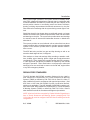
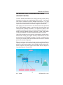
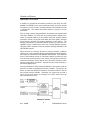
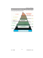
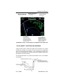
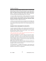
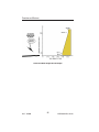
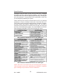
Functions and Features
Geometric Altitude
Displayed as MSL or GSL
Display Orientation
Here Magnetic Track is
up and at 160°.
Range Rings
Outer ring is selected
range, inner ring is half
the selected range. Here
outer ring is 40nm and the
inner ring is 20nm.
Display Range
Nautical Miles
Peaks Elevation
Maximum elevation is
displayed over minimum
elevation. Here maximum
elevation is 6,000ft. and
minimum is 3,000ft.
GA-EGPWS “Peaks” Terrain Display at 12,000 feet near Seattle, WA
“LOOK-AHEAD” ALERTING AND WARNING
Using aircraft position, altitude and flight path information, the system
provides an envelope of protection for the aircraft that is independent
from the Terrain Awareness Display. This “Look-Ahead” function compares the aircraft flight path to terrain and obstacle database information,
and distance to known runways.
The following illustration is a general representation of the “Look-Ahead”
functionality.
Rev 5 Jul/2004
15
KGP 560/860 Pilot's Guide