1
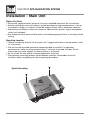
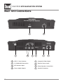
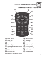
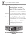
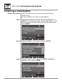
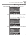
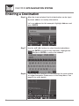
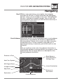
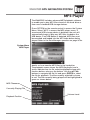
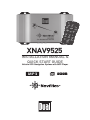
XNAV9525
INSTALLATION MANUAL &
QUICK START GUIDE
Vehicle GPS Navigation System with MP3 Player
XNAV9525 GPS NAVIGATION SYSTEM
Preface
The XNAV9525 GPS navigation system combines state-of-the-art turn-by-turn navigation with
a built-in MP3 player. Before operating, take a few minutes to review the safety and operating
instructions in this Quick Start Guide so you can quickly and safely become familiar with its
many features.
This Quick Start Guide explains the system functions, and provides details on:
• Safety information
• Installing the unit
• Basic navigation functions
• Basic MP3 player functions
For detailed navigation functions, MP3 operation and file transfer information, please refer to
the full-length owner’s manual included in .pdf format on the DVD-ROM. Visit our website at
www.dualav.com for updates and the latest version of this Quick Start Guide.
Copyright and Trademarks
AMD, the AMD arrow logo, and combinations thereof, and Geode and virtual System
Architecture are trademarks of Advanced Micro Devices, Inc.
Windows is a trademark of Microsoft Corporation in the United States and or other
countries.
Other product names are for identification purposes only and may be trademarks of their
respective companies.
This document and the software described in it are furnished under license and may be
used or copied only in accordance with such license. Except as permitted by such license,
the contents of this document may not be disclosed to third parties, copied, or duplicated
in any form, in whole or in part, without the prior written permission of Dual Electronics
Corporation.
Quick Start Guide Version 1.0
Copyright© 2005 All rights reserved.
Design and specifications subject to change without notice.
2
XNAV9525 GPS NAVIGATION SYSTEM
Safety Information and Precautions
WARNING! PLEASE READ AND FOLLOW THE SAFETY PRECAUTIONS BELOW.
FAILURE TO FOLLOW THE INSTRUCTIONS BELOW MAY INCREASE YOUR RISK OF
COLLISION AND PERSONAL INJURY.
The Please Drive Safely screen is displayed each time the navigation system is turned on
as a reminder to make use of the system’s navigational aids in a safe manner.
Before using the system, read this entire Quick Start Guide. Make sure that you are
familiar with the system’s features and know how to operate the system. Proper use of
the navigation system includes the following guidelines:
The navigation system is not a substitute for your personal judgment. The route
suggestions should never supersede any local traffic regulation or your personal
judgment and /or knowledge of safe driving practices. Prior to completing any maneuvers
suggested by your navigation system (for example, a U-turn or a left turn), verify that
you can legally and safely complete the maneuver. Do not follow route suggestions if
they direct you to perform an unsafe or illegal maneuver, would place you in an unsafe
situation, or would route you into an area that you consider unsafe.
Glance at the screen only when necessary and safe to do so. Let the computer voice guide
you. If prolonged viewing is necessary, pull off the road to a safe location.
Do not use the navigation system to locate emergency services (such as police, fire
stations, hospitals, and clinics). The database may not include all emergency service
providers. Use your own best judgment and ask for directions in these situations.
If the vehicle is in motion, only a passenger should program the navigation system.
The driver should not program the system unless the vehicle is parked in a safe location.
The navigation system’s map database provides information on suggested routes without
regard to factors that may affect your driving experience or the time required to arrive
at your destination. For example, the system does not reflect road detours, closures or
construction, some road characteristics (e.g., road surface, slope or grade, weight or
height restrictions, etc.), temporary traffic congestion, weather conditions, and similar
factors.
3
XNAV9525 GPS NAVIGATION SYSTEM
Introduction to Your Navigation System
As you travel, your navigation system functions as your copilot, providing turn-by-turn
visual and voice guidance to direct you to your selected destination. Because the system
knows where you are and where you want to go, it can quickly calculate step-by-step
directions that provide a route to any destination available on the included navigation
map. The map includes millions of roadway and mapping destinations, and
pre-programmed point of interest (POI) locations in over 50 categories. Simply enter your
desired destination into your navigation system, and its advanced intelligence does the
rest.
With your navigation system, if you deviate from the planned route, the system will
automatically recalculate the route to determine a new one from your current
location.
The navigation system uses Global Positioning System (GPS) satellites, and a digital
roadway map database to calculate and display travel directions. The system’s GPS
antenna receives signals from a constellation of 24 satellites orbiting the earth and uses
the strongest of signals, to determine your position to within meters. The navigation
system’s sophisticated software provides the highly accurate positioning necessary to
provide real-time, accurate, turn-by-turn route guidance.
Vehicle Position
The navigation system’s computer considers vehicle speed and heading changes,
together with longitude and latitude information, to accurately determine vehicle heading
and position on a digital map. This information is relayed to you as you proceed to your
selected destination through audible suggestions, turn symbols, and the on screen map.
Signals from GPS satellites are used to determine the vehicle location. Three (good) or
four (best) satellites must be received to accurately determine location. The GPS
reception status is indicated by the GPS icon on the map. See the map display section on
page 19 for more information.
Map and Information Database
The map database used by your navigation system was created using high-resolution
aerial and land based data collection and is stored on a hard disk drive. This data is
enhanced with useful travel information, such as freeway signage and over two million
points of interest locations in over 50 categories, such as tourist attractions, gas stations,
airports, and restaurants.
Car navigation maps are frequently updated. While the database was judged to be as
accurate as possible at the time of its release, a map database can never be 100%
accurate. Road information that is maintained in the map databases, such as turn
restrictions or road names may change over time. In addition, points of interests, such as
restaurants, hotels, and gas stations, also change over time. The complexity of
keeping this directory current means that some information may be missing or
out-of-date at times.
4
XNAV9525 GPS NAVIGATION SYSTEM
Preparation
Please read all instructions carefully before attempting to install or operate the XNAV9525.
Due to its technical nature, it is highly recommended that your DUAL XNAV9525 is
installed by a professional installer or an authorized dealer.
This product is only for use in vehicles with 12VDC negative ground only.
To prevent damage or injury:
• Make sure to ground the unit securely to the vehicle chassis ground.
• Do not disassemble the unit.
• Do not install the unit in a location exposed to direct sunlight or excessive heat or the
possibility of water splashing.
• Do not subject the unit to excessive shock.
• When replacing a fuse, only use a new one with the prescribed rating. Using a fuse
with the wrong rating may cause damage to the unit or cause it to malfunction.
• To prevent short circuits when replacing a fuse, disconnect the wiring harness first.
• Use only the provided hardware and interface cable.
• Do not program the navigation system while the vehicle is moving.
• If you experience problems during installation, consult your nearest Dual dealer.
• If the unit malfunctions, press the power button on the remote control to reset the unit
first. Refer to page 11 for details. If the problem still persists, consult your nearest Dual
dealer or call Dual tech assistance @ 1-866-429-1628.
FCC Notice
This device complies with part 15 of the FCC rules and regulations
Operation is subject to the following two conditions:
1) This device may not cause harmful interference, and
2) This device must accept any interference received, including interference that may
cause undesired operation. This product complies with DHHS rule 21CFR subchapter J
part 1040 at the time of manufacture.
5
XNAV9525 GPS NAVIGATION SYSTEM
Installation - Main Unit
Before You Start
• Disconnect negative battery terminal. Consult a qualified technician for instructions.
• Avoid installing the main unit where it would be subject to high temperatures, such as
from direct sunlight, or where it would be subject to dust, dirt or excessive vibration.
• Stand alone installations require an external video monitor, power, signal and speaker
wires (not included).
• Use extreme caution when drilling holes to avoid damaging fuel lines or existing vehicle
wiring.
Mounting Location
• Choose a mounting location for the main unit. Suggested locations include under a seat
or in the trunk.
• The unit can be mounted horizontal (recommended) or vertical. For optimum
performance, make sure to provide at least 1" of space to around all sides. Do not
mount the unit under carpets or where airflow is restricted.
• Do not install the unit where it may be exposed to moisture.
• The optimum mounting location varies between vehicles. Remember to test all
functions before completing the final mounting procedure.
Typical Mounting
6
XNAV9525 GPS NAVIGATION SYSTEM
Installation - Antenna
• Determine a suitable location for mounting the GPS antenna. For optimum reception,
the antenna should be mounted in the center of the vehicle roof with a minimum of 6”
from any window.
• The antenna can also be mounted to the rear trunk lid at least 4” from the rear window.
• Do not install the antenna in a location where it may obstruct the field of view to the
skyline such as on the front dashboard or rear deck tray.
• Clean the mounting location thoroughly before attaching the antenna. The antenna uses
a powerful magnet and requires no adhesive to apply. Do not slide the antenna during
positioning as damage to the painted surface can occur.
• Once the antenna is mounted, carefully plan the cable route to the XNAV9525. Be careful
not to pinch or twist the antenna cable. Use a grommet when running wires through
any metal openings.
Notes:
Do not install the GPS antenna inside the vehicle - as this will reduce reception
significantly. The antenna must be mounted on a metallic surface for best performance.
If a suitable metal surface is not available, the included metal pad may be used to mount
the antenna on.
GPS Signal
When the system is turned on for the first time (or if it has been idle for several days, or
been moved more than 250 miles while off), it can take several minutes to acquire a GPS
signal. GPS signal acquisition times will be typically less than a minute when the unit is
turned on again.
Typical GPS Antenna Mounting
7
XNAV9525 GPS NAVIGATION SYSTEM
Wiring Diagram - Stand Alone Operation
Wiring Notes
When using the XNAV9525 in stand alone mode, the 13 pin Interface Cable is NOT used.
The following connections are required:
• 4 pin power/speaker connector - *confirmation speaker not required when using the
audio outputs (RCA connections).
• Audio output (RCA connections) - connect to audio input of A/V monitor
• Video output (RCA connection) - connect to video input of A/V monitor
• Remote IR sensor
• GPS antenna
8
XNAV9525 GPS NAVIGATION SYSTEM
Wiring Diagram - Using with Dual XDV8125
XDV8125 Wiring Notes
When using the XNAV9525 with the Dual XDV8125, please note the only connection
required between the XDV8125 and the XNAV9525 is the 13 pin Interface Cable.
The following connections are not required:
• 4 pin power/speaker connector
• Audio output (RCA connections)
• Video output (RCA connection)
• Remote IR sensor
WARNING:
Do not use the 4 pin power/speaker connector and the 13 pin Interface Cable at the same
time - as possible damage may occur.
9
XNAV9525 GPS NAVIGATION SYSTEM
Main Unit Connections
1
3
10
4
2
5
6
7
8
1
USB 1.1 Host Interface
5
Composite Video Output
2
10/100Mb LAN Connection
6
Remote Sensor Input
3
GPS Antenna Input
7
Power/Speaker Connections
4
Stereo Audio Outputs
8
Head Unit Interface
XNAV9525 GPS NAVIGATION SYSTEM
Control Locations - Remote
1
2
3
18
4
17
5
16
6
7
15
8
14
9
13
10
12
11
1
Power On/Off
10
F6 Function Key
2
4-Way - Up
11
Volume Up
3
Audio Mute
12
Volume Down
4
Enter/Select Item
13
F5 Function Key
5
4-Way - Right
14
F4 Function Key
6
System Menu/Navigation Display
15
F1 Function Key
7
4-Way - Down
16
Escape/Previous Screen
8
F3 Function Key
17
4-Way - Left
9
F2 Function Key
18
Navigation Menu
Refer to page 21 for detailed button operation.
11
XNAV9525 GPS NAVIGATION SYSTEM
Operating with Dual XDV8125
Quick Start
Before operating your navigation system, please carefully
read and follow the instructions provided in the “Safety
Information and Precautions” section on page 3.
For detailed XNAV9525 navigation functions and MP3
operation, please refer to the full-length owner’s manual
included in .pdf format on the DVD-ROM.
For detailed XDV8125 functions and operation, please refer
to the XDV8125 owner’s manual included with the XDV8125.
Voice Guidance
Audio Routing
The voice guidance and MP3 audio is routed to the left front
channel of the XDV8125 by default. When an XNAV9525 voice
command is executed, the XDV8125 audio is muted to allow
the voice command to be heard by the driver.
Selecting All Channels
The voice guidance and MP3 audio can be routed to all
channels of the XDV8125 if desired. Press and hold NAVI
then press LOUD to select between the left front and all
channels of the XDV8125. “ALL CH” will momentarily appear
in the XDV8125 2.5” display.
Step 1
Turn on the XDV8125, press NAVI on the front panel. “on
NAVI” will momentarily appear in the XDV8125 display.
Step 2
Press PWR on the XNAV9525 remote control to power up
the XNAV9525 and display the loading screen.
Step 3
Proceed the General Operation on page 13.
DUAL XDV8125 CD/Multimedia Receiver with 2.5” TFT LCD Monitor
(sold separately)
12
XNAV9525 GPS NAVIGATION SYSTEM
Start Up
Power On/Off
Press PWR on the XNAV9525 remote control to power up
the XNAV9525 and display the loading screen.
Loading Screen
After the system boots, the following warning is displayed.
Warning Screen
Press ENTER to accept the warning and to display the map.
Map Screen
Note
If the vehicle is in motion, only a passenger should program
the navigation system. The driver should not program the
system unless the vehicle is parked in a safe location.
13
XNAV9525 GPS NAVIGATION SYSTEM
Entering a Destination
Address/Intersection
14
From the map screen, you can select a destination by
several ways.
For this example, let’s select a street address.
Step 1
Access the navigation menu by pressing the F3 button or
MENU from the remote control. Use the ▲▼ buttons on the
remote to move up/down. Highlight Enter Destination and
press ENTER.
Step 2
Highlight Address/Intersection and press ENTER.
Step 3
Highlight State/Province and press ENTER. Highlight the
desired state and press ENTER.
XNAV9525 GPS NAVIGATION SYSTEM
Entering a Destination
Address/Intersection
(continued)
Step 4
In the example below, California has been selected.
After the State/Province has been selected, the destination
can be input by City Name or Street Name.
Let’s use City Name for this example. Highlight City
Name and press ENTER. Use the ▲▼ buttons to choose
the desired city and press ENTER. Press F2 to select the
previous page and F4 for the next page.
Step 5
Use the ▲▼ buttons to choose the desired street and press
ENTER.
15
XNAV9525 GPS NAVIGATION SYSTEM
Entering a Destination
Step 6
After the street selected, the final destination can be input
by street address or nearby intersection.
Let’s use address for this example. Highlight Address and
press ENTER.
16
Step 7
Use the ▲▼◀▶ buttons to select the desired address,
pressing ENTER to confirm each character. Highlight the
and press ENTER to confirm the address.
Step 8
The system will calculate a route based on the route criteria
set under Navigation Preferences in the Setup Menu. See
page 30 for more details.
XNAV9525 GPS NAVIGATION SYSTEM
Navigating
Step 9
Route Guidance
When route calculations are complete, the navigation
system will tell you to “Please proceed to the highlighted
route” unless you are already on the route. The highlighted
route is indicated in magenta (purple). Once on the route,
voice guidance will instruct you with the turns necessary to
arrive at your destination.
Once the vehicle is on the highlighted route, visual guidance
information is provided on the screen to supplement the
voice guidance. Glance at the screen only when necessary
and safe to do so. Let the computer voice guide you. If
prolonged viewing is necessary, pull off the road to a safe
location.
As you continue on the route, the guidance information is
continually updated to correspond with your progress to the
destination. See the figure below for a description of the
visual guidance information.
Distance to Turn
Road Name or
Sign Information
For Next Turn
Next Turn Symbol
GPS Signal Status
Line to Destination
Compass Heading
Map Scale
Distance to
Destination
Destination
Function Buttons
17
XNAV9525 GPS NAVIGATION SYSTEM
Arriving at the Destination
Step 10
When you are approaching your destination, the destination
is shown on the map screen with a yellow circle outlined in
magenta (purple). A voice message announces that you are
approaching your destination.
When you have arrived at your destination, the name and
address of your destination is displayed. A voice message
announces that you have arrived. See below for an example
of a destination arrival screen.
That’s it! You have arrived at the selected destination.
Be sure to read the rest of this Quick Start Guide to become
more familiar with the many options available on your
navigation system.
Off-Route and Route
Interruptions
If you leave the current route because of some interruption
such as a missed turn, or road construction, the navigation
system will automatically recalculate the route.
If you leave the route to make a stop such as a restaurant
or gas station, the navigation system remembers your
destination. After you re-start the vehicle, the navigation
system will ask if you want to continue your route.
Using Your System
18
Once you understand the main buttons, using the system
is easy! The display screens are intuitive, and the methods
used are similar throughout the functions. The status bar
also provides a reference for where you are in the menus.
You will find that your navigation system is not only useful,
but fun to use as well. Follow the instructions on the
screens and verbal prompts, and soon you will wonder how
you have gone without a navigation system.
XNAV9525 GPS NAVIGATION SYSTEM
Map Display - Overview
Map Display Screen
The Map Display shows roads, road names, and
cartographic features like lakes and rivers. You can adjust
the map scale, the map orientation, map view, status
information display, and the distance units to your own
preferences. Refer to the system setup menus on page 30.
See below for a description of the map screen objects.
Typical map in 2.5D display mode
GPS Signal Status:
Green = 4+ satellites received
Yellow = 3 satellites received
Red = 2 or less satellites received
Park
Vehicle Position
Compass Heading
Railroad Tracks
Map Scale
Current Location
(shown when a route is not active)
GPS Signal Status
Depending on the landscape you encounter along your route,
the GPS symbol may change colors indicating the strength of
the GPS signal. The GPS symbol colors are defined as:
Green
GPS signal is free from obstruction and is being received
regularly. At least four satellites are being received. The
system will perform its best.
Yellow
GPS signal is partially obstructed. Three satellites are being
received. The system will perform well.
Red
GPS signal is unavailable. GPS signal is entirely blocked by
obstructions such as tall trees or buildings. Two or fewer
satellites are being received. The system will not be able to
accurately determine the vehicle location.
Current Location Screen
Your current location can be displayed at any time from the
Map Display screen. Press ENTER and the current road and
city will be displayed.
19
XNAV9525 GPS NAVIGATION SYSTEM
Navigation Menus - Overview
All navigation operations begin with the navigation system’s
navigation menu screen. From this menu, you have three
different options.
Enter Destination
Edit Address Book
Pick a destination for routing.
Add destinations to address book or modify existing entries.
Refer to the full-length owner’s manual included in .pdf format
on the DVD-ROM for details on using the address book.
Setup
Set preferences for routing and navigation display, turn the
simulation on, or diagnose the system.
Before selecting a destination, you can set the route criteria
by selecting Setup and then Navigation Preferences. Route
criteria tells the navigation system your preferences and
how to calculate the route. See page 30 for details.
From the Enter Destination Menu, you have five ways to
select a destination. Several of these methods allow you to
move through a list by scrolling using the ▲▼◀▶ buttons
(List Mode) or, by searching using an on screen keyboard
(Spell Mode). Refer to the full-length owner’s manual included
in .pdf format on the DVD-ROM for more details.
List Mode
List mode refers to scrolling through a list of names using
the ▲▼◀▶ buttons. The name might be a street, a city, or
a point of interest.
Spell Mode
Spell Mode refers to using an on-screen keyboard to spell
a street, a city, or a point of interest in order to shorten the
search time. The speller is “intelligent” and only shows
characters that are available in the list being searched. For
example, if searching hotels and no hotel starting with “Z”
is in the listings, “Z” will not be shown on the on-screen
keyboard.
Most Recently Used
20
Many of the lists keep track of the last five most recently
used (MRU) selections. These are placed at the top of the list
in a different color and allow you to quickly select items that
are used frequently. For example, you may frequently select
addresses in the same city. If that city is in the MRU portion
of the list, you will not have to search through a long list,
just look for it at the top.
XNAV9525 GPS NAVIGATION SYSTEM
Remote Control Functions - Overview
Main Buttons
PWR
MENU
VOLUME
MUTE
ESC
ENTER
▲▼◀▶
SYSTEM
The main buttons for using the navigation menus include
ENTER, ESC, MENU, and the ▲▼◀▶ buttons. These
buttons allow you to move through the navigation menus as
well as pan the map and select destinations from the map.
The main buttons on the remote control function as follows:
Press to turn the system on/off.
Press to display the navigation menu. It is the first step to
selecting a destination.
Press + to turn the volume up.
Press - to turn the volume down.
Press to mute the voice guidance or the MP3 audio.
Press this button exits to the prior screen.
In menu mode, this button will select the currently
highlighted item. In map mode, this button will display
information on the currently displayed location. Press a
second time to use the currently displayed location as a
destination or address book entry.
Pressing these buttons navigate through the menus. They
may also be used to pan the map.
Press to display the system menu. The system menu allows
you to select the following options:
MP3 Player
Display Setup
Data Manager
The XNAV9525 includes advanced MP3 playback software
to enable you to play MP3 files stored on the hard drive or
from most standard USB storage devices. See page 23 for
more information on playing MP3 files.
The Display Setup option enables you to adjust display
screen position on the monitor.
The Data Manager allows you to transfer MP3 files to the
system hard drive and perform system upgrades. Refer to
the full-length owner’s manual included in .pdf format on the
DVD-ROM for more details.
21
XNAV9525 GPS NAVIGATION SYSTEM
Remote Control Functions - Overview
Function Buttons
The buttons shown at the bottom of the display are
called function buttons. These buttons (F1, F2, F3, F4, F5,
F6) change labels depending on the screen displayed;
consequently, they also have changing functions. The table
below provides a brief description of the function buttons.
Refer to the full-length owner’s manual included in .pdf format
on the DVD-ROM for more details.
Navigation - Remote Control Operation
Cancel current action
Zoom in the map to show a smaller area
Zoom out the map to show a larger area
Center map on current vehicle location
Display menu
Display map in perspective view
Display map in split planar and perspective views
Display map in planar view
In split screen view, change active side for panning, etc from left to right
In split screen view, change active side for panning, etc from right to left
After panning map, select current panned position
Select currently highlighted item
Display list mode
Display spell mode
Page up in displayed list
Page down in displayed list
22
XNAV9525 GPS NAVIGATION SYSTEM
MP3 Player
The XNAV9525 includes advanced MP3 playback software
to enable you to play MP3 files stored on the hard drive or
from most standard USB storage devices.
Press SYSTEM on the remote control to access the System
Menu. Select “MP3” to access the MP3 player menu. If
an external USB storage device is detected, the unit will
automatically begin to play any MP3 files loaded on the
USB device. If no USB device is detected, MP3 files must
be searched and loaded into the MP3 index before being
played. Refer to the Data Manager operation on page 26 for
System Menu
MP3 Player
details on how transfer MP3 files to the hard drive.
The playback screen shows the MP3 file playlist and a
status indicator bar for file selection/playback along with
function buttons along on the bottom. Use the ▲▼◀▶
buttons to navigate the file list and press ENTER to select
the file for playback. The file currently selected is shown
in red. The file currently being played will be highlighted in
green as shown below.
MP3 Filenames
Currently Playing File
Playback Position
Volume Level
23
XNAV9525 GPS NAVIGATION SYSTEM
MP3 Player Remote Control Functions
MP3 Player - Remote Control Operation
◀
Selection moves to the previous file and begins playback.
▶
Selection moves to the next file and begins playback.
Starts MP3 playback of currently selected file.
Stops MP3 playback.
Activates the MP3 file search mode.
Activates MP3 file repeat mode. The button color changes to red
indicating file repeat mode.
Activates MP3 file random playback mode. The button color changes to
red indicating file random playback mode.
▲
▼
Moves the cursor in the index play list.
+
Increases the volume.
-
Decreases the volume.
MUTE
ESC
Toggles the MUTE function on/off.
Exits the MP3 player and returns to the System menu. In the File Search,
exits the File Search and returns to the MP3 index.
Notes
Warning
24
Additional MP3 playback functions are located along the
bottom of the MP3 Player screen. Volume level is indicated
in the red bar graph along with the playback position
indicator bar graph shown in green. While it is possible to
play MP3 files during navigation or file transfer, some erratic
audio/sounds may be heard - slight MP3 audio dropouts, etc.
This is normal and there is no cause for concern.
If a USB storage device is removed from the system during
MP3 playback, file playback will terminate. Sudden removal
of a USB storage device may damage the files and/or the
system. Depending on the storage device, it can take
several minutes for the system to recognize the device
during MP3 file search/playback.
XNAV9525 GPS NAVIGATION SYSTEM
Display Setup
Screen Position
Adjustment
Display Setup enables you to adjust display screen position
on the monitor.
System Menu
Display Setup
From the System Menu, select “Display Setup” to adjust
the display screen position. If the XNAV9525 is used in
combination with external monitor, the display screen may
not be centered. This symptom is not abnormal and it varies
with individual monitor characteristics.
Use the ◀▶ buttons to adjust the display left and right
accordingly. A current status window is displayed at the
right side of the screen and it displays the maximum view
area that the screen can be adjusted to. Press ESC to return
to the System Menu.
Display Setup Screen
25
XNAV9525 GPS NAVIGATION SYSTEM
Data Manager - Overview
The default Data Manager allows you to transfer MP3 files
to your system without the possibility of deleting any system
files. In the default Data Manager mode, Hard Disk and Hard
Disk2 partitions are protected - preventing files from being
deleted by mistake.
From the System Menu, select “Data Manager” to access the
default Data Manager.
In the default Data Manager mode, only Hard Disk3 can be
accessed for MP3 file transfer or deletion. Hard Disk and
Hard Disk2 partitions can be browsed but not altered or
deleted to protect the critical system files and navigation
software.
System Menu
Data Manager
The Data Manager includes two windows for folder/file
navigating as shown.
Data Manager Menu
Windows
Notes
26
The default directory for storing MP3 files on the hard drive
is Hard Disk3/Mdata. Storing MP3 files in other directories
may not allow the unit to search and playback properly.
XNAV9525 GPS NAVIGATION SYSTEM
Data Manager - Browse/Copy Files
Browse Folders/Files
Copy Folder/Files
Browse folders/files by moving the yellow cursor using the
▲▼◀▶buttons. Highlight desired folder or file and press
ENTER to select. Folders with sub folders are displayed in
the same window. Press F1 to go up one folder level. Press
the ◀▶buttons to move between the left and right side
windows.
Folder/file copy allows you to copy folders/files from one
place to another. Only the selected folders or files in the
left side window will be copied to the selected folder in the
right side window. Select the target folder/files to be copied
in the left side window. Select the destination folder in the
right side window. Press F2 to begin copying the selected
folder or file. Several folders/files may be selected at one
time by pressing F5. As shown below, 4 MP3 files have been
selected for copy from Hard Disk4 (external USB storage
device) to the Mdata folder located on Hard Disk3.
Data Manager
Multiple File Select
Data Manager
Folder/File Copy Progress
Note
Any device
plugged into the
USB port will
show up in the
Data Manager
as “Hard Disk 4”.
Hard Disk 4 can
not be renamed.
The copy progress box indicates the status of folder/file
process. As the copy function completes, the progress box
disappears automatically and the copied folders/files are
displayed in the right side window as the result. Press ESC
to cancel the copy function during folder/file copy process.
27
XNAV9525 GPS NAVIGATION SYSTEM
Data Manager - Delete Folders/Files
Delete Folder/Files
Notes
The Delete function allows any folders/files on the Hard
Disk3 partition to be deleted.
Folders/files located on the Hard Disk or Hard Disk2
partitions can not be deleted using the default Data Manager.
The Delete function can be performed from both left and
right windows. Select the folder/files to delete by moving the
yellow box cursor to the selected folder/files. Press F5 to
select all files and folders in the left side window. As shown
below, 4 MP3 files have been selected for deletion from the
Mdata folder on Hard Disk3.
Data Manager
Multiple Files Selected for
Deletion
Press F3 to begin the folder/file deletion process.
Data Manager
Deletion Confirmation Box
Note
28
As an added protective measure, the file delete confirmation
box will appear to confirm the intended file deletion. Select
YES to confirm the deletion.
XNAV9525 GPS NAVIGATION SYSTEM
Data Manager - Create Folders
Create New Folders
Notes
New folders can be created to manage and organize MP3
files. For optimum performance, it is only recommended to
add new folders to the Hard Disk3 partition of the hard drive.
Folders created on the Hard Disk or Hard Disk2 partitions
can not be deleted using the default Data Manager. The
default folder name for all new folders is “NewFolder”,
NewFolder1”, etc. These folder names can not be renamed.
To create a new folder, navigate to the desired location using
the ▲▼◀▶buttons.
Press F4 to create the folder at the selected location. New
folders can be created from the left or right side windows.
The example below shows NewFolder and NewFolder1
added to the left side window in the Hard Disk3\Mdata
folder.
Data Manager
Create New Folder
Data Manager
Create New Folder
For detailed Data Manager functions, operation and file transfer
information, please refer to the full-length owner’s manual
included in .pdf format on the DVD-ROM. Visit our website for
updates and the latest information at www.dualav.com.
29
XNAV9525 GPS NAVIGATION SYSTEM
System Setup Menu
You can customize the navigation system appearance
and functions to your own preferences. From the map
screen press MENU, then select Setup to adjust navigation
preferences, display options, and units (km or mi) settings.
You may also reset the vehicle position and perform basic
system diagnostics through the setup menu.
Setup Menu
Navigation Preferences allows you to turn on the simulation
mode and set the route calculation and guidance options.
Navigation Preferences
Menu
30
XNAV9525 GPS NAVIGATION SYSTEM
System Setup - Preferences Menu
Simulation On/Off
When selected, the GPS icon will be replaced with a DEMO
icon and allow the system to “drive” the selected route
even though the vehicle is not moving. This can be used to
preview a route without leaving your driveway.
Shortest Time/Distance
Determines if the navigation system emphasizes finding the
fastest or the shortest route.
Avoid Freeway Yes/No
Determines if the navigation system avoids or uses freeways
in the route calculation.
Toll Yes/No
Auto Recalc On/Off
Voice Guidance On/Off
Determines if the navigation system uses toll roads in the
route calculation.
When selected, the system will automatically recalculate the
route if the current route is deviated - like a missed turn.
When selected, the system will give audible guidance.
31
XNAV9525 GPS NAVIGATION SYSTEM
System Setup - Display Options
Display options allow you to set the map orientation and the
information displayed on the map.
Display Options Menu
North Up/Heading Up
Note
GPS Icon Display On/Off
32
Determines if the map is always displayed with North
direction at the top of the screen or if map is always adjusted
so that vehicle symbol points toward the top of the screen.
Default setting is North up when zoom is set to greater than
1 mile.
Turn the display of the GPS reception symbol on or off.
XNAV9525 GPS NAVIGATION SYSTEM
System Setup - Display/Distance Options
Status Bar Display On/Off
Turn the display of the status bar on or off.
Scale Icon Display On/Off
Determines if the map scale symbol is shown.
Compass Icon Display
On/Off
Turn the compass symbol on or off.
Next Maneuver On/Off
Set the display of the turn symbol.
Soft Keys On/Off
Enlarged Intersection
On/Off
Turn the function key display on or off
Turn the true view on or off.
Set Distance Units Menu
Distance Units Selection
Note
The units used when displaying and announcing the distance
to turns may be set to miles (plus decimal miles, e.g. zero
point three miles), kilometers/meters, or miles/yards based
on personal preferences.
The XNAV9525 includes other system preferences not
covered in this Quick Start Guide. Refer to the owner’s
manual included on the DVD for more information.
33
XNAV9525 GPS NAVIGATION SYSTEM
Limited One Year Warranty
This warranty gives you specific legal
rights. You may also have other rights
which vary from state to state.
Dual Electronics Corp. warrants this
product to the original purchaser to be free
from defects in material and workmanship
for a period of one year from the date of
the original purchase.
Dual Electronics Corp. agrees, at our
option, during the warranty period,
to repair any defect in material or
workmanship or to furnish an equal
new, renewed or comparable product
(whichever is deemed necessary) in
exchange without charges, subject to
verification of the defect or malfunction and
proof of the date of purchase. Subsequent
replacement products are warranted for
the balance of the original warranty period.
Who is covered? This warranty is extended
to the original retail purchaser for products
purchased and used in the U.S.A.
What is covered? This warranty covers
all defects in material and workmanship
in this product. The following are not
covered: installation/removal costs,
damage resulting from accident, misuse,
abuse, neglect, product modification,
improper installation, incorrect line
voltage, unauthorized repair or failure
to follow instructions supplied with the
product, or damage occurring during
return shipment of the product.
34
What to do?
1. Before you call for service, review your
owner’s manual. A slight adjustment
of any custom controls or connections
discussed in your owner’s manual may
save you a service call.
2. If you require service during the
warranty period, you must carefully
pack the product (preferably in the
original package) and ship it by prepaid
transportation with a copy of the original
receipt from the retailer to an authorized
service center.
3. Please describe your problem in
writing and include your name, a
return UPS shipping address (P.O. Box
not acceptable), and a daytime phone
number with your shipment.
4. For more information and for the
location of the nearest authorized
service center please contact us by one
of the following methods:
Call us toll-free at 1-866-429-1628
E-mail us at [email protected]
Exclusion of Certain Damages: This
warranty is exclusive and in lieu of any
and all other warranties, expressed or
implied, including without limitation the
implied warranties of merchantability and
fitness for a particular purpose and any
obligation, liability, right, claim or remedy
in contract or tort, whether or not arising
from the company’s negligence, actual
or imputed. No person or representative
is authorized to assume for the company
any other liability in connection with the
sale of this product. In no event shall the
company be liable for indirect, incidental or
consequential damages.
XNAV9525 GPS NAVIGATION SYSTEM
Troubleshooting
Problem
Cause
Unit will not turn on Red wire not connected or incorrect voltage
(no power)
Black wire not connected
Unit has power
(but no sound)
Unit blows fuses
No GPS signal
(red icon)
Action
Check connections for proper voltage
(11~16VDC)
Check connection to ground
Fuse blown
Replace fuse
No connection to Dual head unit
Check 13 pin cable connections
Confirmation speaker not connected
Check connections at speaker
RCA audio output not connected
Check RCA audio connections
Voice guidance turned off
Check Preferences menu (see page 31)
Left front speaker not connected (XDV8125)
Select all channels (see page 12)
Red wire touching chassis ground
Check for pinched wire
Incorrect fuse rating
Use fuse with correct rating
The GPS antenna is not connected
Check GPS antenna connection
The GPS antenna cable is damaged
Check for pinched or cur antenna cable
The GPS signal is blocked (such as inside a
tunnel or garage)
Make sure the antenna has an unobstructed
view of the horizon
System Reset
Occasionally, your system may appear to stop responding or be “locked up”. To reset
your system, press the PWR button on the remote control. Press PWR again to reboot the
system; operation should return to normal. Resetting your system is similar to restarting
a computer. If the problem still appears after resetting the unit, please contact technical
support for further assistance.
USB Storage Device Compatibility
Due to ongoing technological advancement of USB storage devices, some USB storage
devices may not be compatible with the XNAV9525.
35
XNAV9525 GPS NAVIGATION SYSTEM
Specifications
General
MP3
Notes:
Windows® CE.Net 4.2 operating system
32-Bit AMD Geode™ 1200 CPU
266MHz Processor
64MB SDRAM
32MB Flash ROM
VGA Resolution output (640 x 480)
4MB VGA RAM
12 Channel GPS receiver
20GB 2.5” hard drive
2MB data buffer
10 GB dedicated MP3 storage
Pre-loaded USA and Canada maps
Approximately 2 million points of interest
Sampling Frequency Rates: 8kHz ~ 48kHz
Transfer Bit Rates: 56kbps ~ 320kbps constant
Variable bit rates
Some MP3 files may not play or be displayed correctly,
depending on sampling rates and bit rates.
This model will not display ID3 tags.
For best results, use the following settings:
128kbps or higher constant bit rate
44.1kHz or higher sampling frequency
Connections
13 Pin data cable (for use with select Dual head units)
Stereo audio outputs (RCA)
Composite video output (RCA)
Voice guidance speaker output
12VDC Power supply input
Remote IR sensor input
GPS antenna input
USB 1.1 host interface
10/100Mb LAN interface
Operating voltage: 11-16 VDC, negative ground
Fuse: 2 amp AGC
Antenna system: 12 channel parallel GPS
Unit dimensions: 8.63” W x 2.25” H x 6” D
Design and specifications subject to change without notice.
Dual Electronics Corporation
Technical Support: 1-866-429-1628
www.dualav.com
NSA0705-V01