
1
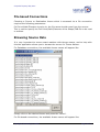
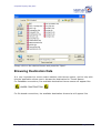
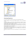
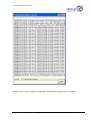
Title:
Spatial Data Loader User Manual
Applicable to:
Spatial Data Loader in AusGIS.
Category:
User Manual
Author:
Spatial Tapestry
Copyright Date:
20th May 2007
Spatial Tapestry Pty Ltd ACN: 115 227 784 19/1 Pitt Street Loftus NSW 2232 Australia
www.spatialtapestry.com.au Email: [email protected]
Ph: (612) 9545 7730 Fax: (612) 9545 7731
© Spatial Tapestry May 2007
Table of Contents
1. Introduction........................................................................................... 3
2. Introduction........................................................................................... 4
Source Formats......................................................................................................4
Destination Formats................................................................................................4
External Tools being used........................................................................................4
The Script File format.............................................................................................5
3. Application Startup................................................................................. 6
Figure 1 Viewing Original vs Processed Geometries......................................................6
Figure 2 Viewing Original vs Processed Geometries......................................................6
Add an SDL...........................................................................................................7
Select All SDLs.......................................................................................................7
Clear All SDLs........................................................................................................7
Run SDLs..............................................................................................................7
Save SDLs.............................................................................................................7
Edit this SDLs........................................................................................................7
Delete this SDL......................................................................................................7
4. Defining a new/editing “Spatial Data Loader” translation...................... 8
Figure 3 Viewing Original vs Processed Geometries......................................................8
Database Connections.............................................................................................9
Server Name/IP:....................................................................................................9
Database Name:....................................................................................................9
SDE Instance/Port Number:.....................................................................................9
Login Name:..........................................................................................................9
Password:.............................................................................................................9
Theme Name:........................................................................................................9
File based Connections..........................................................................................10
Browsing Source Data...........................................................................................10
Browsing Destination Data.....................................................................................11
Choosing Projections.............................................................................................12
Save this 'Spatial Data Load'..................................................................................14
Table of Figures
Figure 1 Viewing Original vs Processed Geometries.................................... 6
Figure 2 Viewing Original vs Processed Geometries.................................... 6
Figure 3 Viewing Original vs Processed Geometries.................................... 8
Topological Processing in AusGIS
Page 2 of 14
© Spatial Tapestry May 2007
1. Introduction
AusGIS is a purpose built GIS to facilitate Spatial Upgrades and Topological
Processing. AusGIS has been built solely to act as the front end GIS to SAM and
other tools being developed by Spatial Tapestry.
The Spatial Data Loader (SDL) provides a flexible, powerful and well-proven
mechanism to transfer spatial and aspatial data between a variety of spatial and
aspatial formats.
This document describes how to use this module, and lists the supported formats.
Topological Processing in AusGIS
Page 3 of 14
© Spatial Tapestry May 2007
2. Introduction
The Spatial Data Loader has been written to provide both an interactive GUI and a
‘Batching’ tool to transfer data from a data source such as an ESRI SDE database or
an ESRI shape file to a destination such as PostGIS or Oracle Spatial. Some geoprocessing capabilities are provided, and an option exists such that 'if and only if a
change is detected in the coordinates or the attribute data comprising the source
theme that the destination theme is re-written.
Source Formats
The SDL can read from the following formats:
•
Shape File (ESRI via Kenneth McVay’s ShapeIO)
•
Tab File (MapInfo via the mitab.dll)
•
Oracle tabular and SDO_Geometry
•
PostGres and PostGIS
•
ESRI SDE and Personal GeoDatabases
•
MS Access – Tabular and GML Version 1.2
•
MS SQL Server – Tabular and GML Version 1.2
•
DB Coord List – Integral Energy site specific format
•
PCPlans Format (South Australian format for Survey
•
SQL Files – read and executed against a database – no geo-processing
available
Destination Formats
The SDL can write to the following formats:
•
Shape File (ESRI via Kenneth McVay’s ShapeIO)
•
Tab File (MapInfo via the mitab.dll)
•
Oracle tabular and SDO_Geometry
•
PostGres and PostGIS
•
ESRI SDE and Personal GeoDatabases
External Tools being used
The SDL uses the following external tools which may need to be installed:
•
The MiTab.DLL for MapInfo Tab Files
Topological Processing in AusGIS
Page 4 of 14
© Spatial Tapestry May 2007
•
The Microsoft OLDB layer for sources and destinations such as Access and
SQL Server
•
The OO4O layer for Oracle
•
Proj4 for any projection changes
The SDL uses VB6 public domain source code (Kenneth McVay) to write/read shape
files, but this is compiled into the SDL tool therefore does not need any separate
installation.
Specifically, a change in the table/theme fields, either in number of fields or field
names, will cause a log file to be written BUT the new shape file will NOT be
written. This has been implemented this way to prevent the TMIS software
performing in an unsatisfactory fashion due to changing to inappropriate data.
In all cases a log file is created for each theme, with the file name comprising the
theme name and the PC’s date, and a line written indicating the results of the
comparison.
The Script File format
The SDL Application is required to manage a number of translations. The record of
the translations is held in a file with the extension “.SDLoader” which may be found
in the same directory as the application is run from.
Each line in this text file looks like:
<Srce>SDEConn</Srce><Server_IP_Srce>tmcweb01</Server_IP_Srce><Database
_Srce>tmcsd</Database_Srce><SDEInstance_Srce>5151</SDEInstance_Srce><L
oginName_Srce>OPL</LoginName_Srce><Password_Srce>OPL</Password_Srce><T
hemeName_Srce>tmcsd.ADM.vms</ThemeName_Srce><SrcePrj4>3000001</SrcePrj
4><Dest>ShpFile</Dest><DestFullFileName>c:\vms.shp</DestFullFileName><
DestPrj4>4283</DestPrj4>
XML formatting is used encode the various items for each translation.
To run this application on a regular basis, it is required to set up a new ‘Scheduled
Task’ (in the Windows ‘Control Panel’). The task should (likely) point to a batch file,
which in turn points to the “_SDL.EXE” with a command line of “auto”. When the
‘Spatial Data Loader’ is run with this command line, no forms are displayed, and the
application will terminate cleanly when the translations have been completed.
The following pages describe how to operate this application.
Topological Processing in AusGIS
Page 5 of 14
© Spatial Tapestry May 2007
3. Application Startup
Figure 1 Viewing Original vs Processed Geometries
When the ‘Spatial Data Loader’ is run in interactive mode the following form is
displayed.
Figure 2 Viewing Original vs Processed Geometries
Topological Processing in AusGIS
Page 6 of 14
© Spatial Tapestry May 2007
The following options are available.
Add an SDL
This allows the user to define a new “SDL” translation.
This is described later in this document.
Select All SDLs
This will cause all SDLs to be selected, which means they will all be processed when
the “Run SDLs” button is clicked.
Clear All SDLs
This will cause all SDLs to be unselected, which means they will all NOT be
processed when the “Run SDLs” button is clicked.
Run SDLs
This will cause the SDLs with their entry ‘checked’ to be run, which means the
source theme will be compared with the destination theme (if available) and if any
differences are found, the theme will be (over) written.
Save SDLs
This will cause the SDLs translations to be saved to the “SDL.TXT” file, which
means that they will be displayed when the “Spatial Data Loader” application is
next started.
Edit this SDLs
This will cause the current SDLs translation to be loaded to the “Select Spatial
Datasets” Form ready for editing.
Delete this SDL
This will cause the current SDLs translations to be deleted.
Please click on “Save SDLs” to rewrite the “SDL.TXT” file if the SDL is to be
permanently deleted.
Topological Processing in AusGIS
Page 7 of 14
© Spatial Tapestry May 2007
4. Defining a new/editing “Spatial Data Loader”
translation
The following form is displayed when a new Spatial Data Loader translation is
requested or an existing translation needs to be edited.
The form is broken into two main sections, one for the source theme being read,
and the second for the destination theme being compared and potentially (over)
written.
Figure 3 Viewing Original vs Processed Geometries
Accessing spatial themes in relational databases requires database connection
parameters whilst accessing spatial themes in flat files requires directory names
and theme names.
Topological Processing in AusGIS
Page 8 of 14
© Spatial Tapestry May 2007
The same parameters are needed whether the purpose is to read the spatial data or
write the spatial data.
Hence the same types of connection data is collected for the source theme (being
read) and the destination theme (being read, compared and potentially
overwritten).
Database Connections
Choosing a Source or Destination theme which is accessed via a database
connection requires the following parameters:
Server Name/IP:
This may be either the server name or the IP address of the computer running the
SDE/Database instance.
Database Name:
This is the Database name on the computer running the SDE/Database instance.
SDE Instance/Port Number:
This may be either the SDE Name or the Port Number of the database instance on
the computer running the SDE/Database.
Note: the SDE Name must be in the C:\WINDOWS\system32\drivers\etc\services
file.
Login Name:
This is the user’s login name on the computer running the SDE/Database instance.
Password:
This is the user’s password on the computer running the SDE/Database instance.
Theme Name:
This is the Theme/Table name on the computer running the SDE/Database
instance.
Topological Processing in AusGIS
Page 9 of 14
© Spatial Tapestry May 2007
File based Connections
Choosing a Source or Destination theme which is accessed via a file connection
requires the following parameters:
Full Drive\Path\Filename to write to, the file name should come from the source:
This is used to specify the Full Drive\Path\Filename of the Shape/TAB file to be read
or written.
Browsing Source Data
It is very important to ensure exact matches with theme names, and to help with
this the application allows you to browse the source for Theme Names.
For Database connections, the available theme names will appear like:
Simply click on the desired theme and press the ‘Select’.
For file based connections, the available theme names will appear like:
Topological Processing in AusGIS
Page 10 of 14
© Spatial Tapestry May 2007
Simply click on the desired theme and press the ‘Open’.
Browsing Destination Data
It is very important to ensure exact matches with theme names, and to help with
this the application allows you to browse the destination for Theme Names.
For Database connections, the available destination theme names will appear like:
“
UNDER CONSTRUCTION
”
For file based connections, the available destination directories will appear like:
Topological Processing in AusGIS
Page 11 of 14
© Spatial Tapestry May 2007
Choosing Projections
It is critical to match the projection for both source and destination themes.
The SDL application uses the Proj4 ‘Projection Engine’ to carry out projection
changes.
A Projection Engine is a toolset that converts latitude and longitude (typically
expressed in decimal degrees), which is a spheroidal coordinate system, to a planar
coordinate system typically expressed in metres.
The RTA typically uses a Lambert Conic Conformal projection with parameters
optimised for the position of NSW in the Australian standard definition of the globe’s
size and orientation which is called GDA94.
This RTA definition is given the number 3,000,001 in this application. All data held
in the RTA’s SDE is held in this projection.
TMIS uses latitude and longitude for its base coordinate system, and GDA94 has
been selected as the standard definition of this. GDA94 has the number 4283
assigned to it by the Proj4 team.
Choosing the projection for both source and destination is the same, and appears
as:
Topological Processing in AusGIS
Page 12 of 14
© Spatial Tapestry May 2007
Simply click on the projection required for the theme being read or written.
Topological Processing in AusGIS
Page 13 of 14
© Spatial Tapestry May 2007
Save this 'Spatial Data Load'
This is used to save the edits back to the “Spatial Data Loader” form. This does
NOT write the ‘SDL.Txt’ File. You must use the “Save SDLs” button on the “Spatial
Data Loader” form to write any edits to the ‘SDL.Txt. file.
Topological Processing in AusGIS
Page 14 of 14


![Intergraph Geomedia [6.1-2013] User manual](http://vs1.manualzilla.com/store/data/005689587_1-58c82d14f3ba8ebe92b5c45af00d079c-150x150.png)