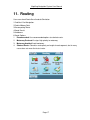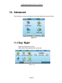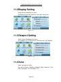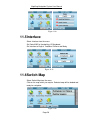
1
MapKing Navigation System
User Manual
Copyright © 2010, MapAsia.com Limited
MapKing Navigation System User Manual
1. Table of Contents
1.
Table of Contents ....................................................................................................... 1
2.
Copyright .................................................................................................................... 2
3.
Special Statement....................................................................................................... 3
4.
Disclaimer ................................................................................................................... 4
5.
Introduction ................................................................................................................ 5
6.
Registration ................................................................................................................ 6
7.
Main Menu................................................................................................................... 7
8.
Map View ..................................................................................................................... 8
9.
Destination.................................................................................................................. 9
8.1
8.2
8.3
8.4
Search by category............................................................................................ 9
Home ............................................................................................................... 11
History ............................................................................................................. 12
My Favourite .................................................................................................... 13
10. Navigation ................................................................................................................. 15
11. Routing...................................................................................................................... 17
12. Advanced .................................................................................................................. 18
11.1
11.2
11.3
11.4
11.5
11.6
11.7
11.8
Day/ Night ........................................................................................................ 18
Display Setting................................................................................................. 19
Viewport Setting............................................................................................... 19
Voice................................................................................................................ 19
Interface........................................................................................................... 20
Switch Map ...................................................................................................... 20
Safety Mode..................................................................................................... 21
About ............................................................................................................... 21
13. GPS............................................................................................................................ 22
14. Support...................................................................................................................... 23
14.1
14.2
FAQ ................................................................................................................. 23
Technical Support ............................................................................................ 24
Page 1
MapKing Navigation System User Manual
2. Copyright
All title, ownership, derivative works and copyrights in the SOFTWARE are owned by
MapAsia and incorporated suppliers. No right, title or interest in or to any trademark, logo
or trade name of MapAsia or incorporated suppliers is granted under this AGREEMENT.
The Logo of MapAsia and MapKing™ is owned by MapKing International Limited.
Copyright of the GIS Database is owned by MapAsia.com Limited and Data partners’
that have come to contract with and be specified by MapAsia.com.
SOFTWARE PRODUCT LICENSE
The SOFTWARE is protected by local, international copyright laws and other intellectual
property laws treaties.
MapKing™ is the registered logo and or logo of MapAsia.com Limited in the United
States of American and other countries.
MapAsia is the registered logo and or logo of MapAsia.com Limited in the United States
of American other countries.
Other undeclared LOGO and Licenses belong to the owner of the copyright owner.
Copyright © 2010,
MapAsia.com Limited
MapKing International Limited
Page 2
MapKing Navigation System User Manual
3. Special Statement
IMPORTANT MESSAGE CONCERNING
THE USE OF MAPKING™ BY VEHICLE DRIVER
TO ENSURE SAFETY DRIVING, WE STRONGLY ADVISE THAT A DRIVER SHOULD
NOT OPERATE MAPKING™ WHILE DRIVING THE VEHICLE SIMULTANEOULSY. A
DRIVER SHOULD NEVER FOCUS HIS OR HER ATTENTION ON THE MAPKING™
DISPLAY WHILE DRIVING.
We suggest that MapKing™ should be operated by a passenger other than the driver or
the driver should stop the vehicle at a convenient spot before starting to use MapKing™.
IMPORTANT MESSAGE CONCERNING ROUTE PLANNING
The route planning function of MapKing™ is ONLY meant to be and should ONLY be
used as a crude reference. IT SHOULD NEVER BE USED TO DETERMINE ACTUAL
DRIVING DIRECTIONS. The route planning function of MapKing™ is subject to the
following limitations:
Whilst we have taken great care and endeavours in developing the product, we
CANNOT guarantee that the road network data and routing calculations of
MapKing™ are free of any omission or defect.
The road network and traffic conditions in the real world are ever changing,
MapKing™ being a pre-packaged product cannot reflect all these changes on a
constant basis.
Road network parameters specifically required for route planning, like one-way
traffic indicator or turn restrictions at street crossing, are difficult or almost
impossible to obtain for China or some other Asian countries. The lack of these data
would significantly affect the performance of route planning.
IMPORTANT MESSAGE CONCERNING GPS TRACKING
The GPS tracking function of MapKing™ works on GPS satellite signals broadcasted for
civilian use. It is subject to inherent signal deviations and environmental interferences
caused by surroundings and bad weather. We cannot guarantee nor specify a precise
level of accuracy for the GPS positioning data displayed by MapKing™. It should also be
noted that the Unites States Department of Defence, who builds and operates the GPS
system, is free to turn off or down-grade the civilian signals of GPS during rare occasions
like regional military conflict. Although MapKing™ should work with most GPS receivers
on NMEA0183 signal output format regardless of their brand name or model; we cannot
guarantee that MapKing™ integrates flawlessly with ALL GPS receivers available in the
market.
Page 3
MapKing Navigation System User Manual
4. Disclaimer
Map Accuracy Disclaimer
Maps (including directions, phone, address, etc.) will change over time and becomes
inaccurate. Please stop using the outdated map content. As the content of this map does
not automatically update, so it can only be used for reference. Please do not rely solely
on the content of the map for navigation. If in doubt, please check before use.
GPS / AGPS performance and fees Disclaimer
GPS / AGPS connection time will be affected by different environment and weather
conditions. As AGPS network providers rely on data transmission services, your network
provider may charge you for data transmission and other related expenses. Please note
that if the A-GPS service is being used in overseas, roaming charge will be applied. For
Long-range charge details, please contact your network provider.
Page 4
MapKing Navigation System User Manual
5. Introduction
MapKing Navigation System is an easy-to-use navigation device, which provides rich
real time navigation information such as location, speed, etc. Paired with a powerful high
resolution map browser, this device helps users enjoy more of their trips.
Intelligent Navigation:
Planning Route: Choose ‘Recommended’, ‘Highway Avoided’, ‘Walking Mode’,
‘Shortest Route’.
Finding Places: Setting Start and End points on the map or via search function.
Navigation Modes: Switching among 3D, 2D and list modes.
Voice Navigation: With voice navigation, users can focus more on driving.
Searching Functions:
Map Searching: Search address, point of interest, petrol stations etc. by area.
Other Searching: Setting home and my favourite and reviewing search history.
Features:
Powerful navigation device.
User friendly interface.
Software and all map data are stored in SD card.
* Only Registered user can enjoy update and customer support, please refer to items on
Product Authorization Card.
Page 5
MapKing Navigation System User Manual
6. Registration
From the package, you will have a “Product Authorization Card” with a “Product
Authorization Code”. To get the “Registration Code”, please follow the registration
process below:
Step 1: Please go to http://www.MapKing.com/.
Step 2: Please click “Registration”.
Step 3: Please choose “Registration”.
Step 4: Please fill in your information and the “Product Authorization Code”.
Step 5: After system confirms your “Product Authorization Code”, a “Registration Code”
will be generated for you.
Page 6
MapKing Navigation System User Manual
7. Main Menu
Immediate after entering MapKing, you have access to the main menu.
Navigation: enter navigation system.
Routing: plan for the route / midpoint and set routing opinions
GPS: view the GPS status
Map View: start planning for start point and destination.
Navigation: see the routing result
Advanced: access to advanced settings
Figure 6a
Page 7
MapKing Navigation System User Manual
8. Map View
Select Map View from the Main Menu to browse map.
Main Menu: back to Main Menu
(GPS logo): back to current location
Tap-and-hold on map to call the menu.
Navi: set map location as Midway Point, Destination, Start Point
X,Y: Longitude and latitude
My Favorites: Add to My Favorite.
Speed Camera: set as Speed Camera.
Figure 7a
***
Figure 7b
Page 8
MapKing Navigation System User Manual
9. Destination
Select Destination from the Main Menu to select Destination.
Figure 8a
8.1 Search by category
There are various categories:
1.
2.
3.
4.
5.
6.
7.
8.
9.
Find Road
Intersection
Find POI
Petrol Station
Parking Area
Restaurant
Hotel/Motel
Shopping
Entertainment
11.
12.
13.
14.
15.
16.
17.
18.
19.
Page 9
Education
Transportation
Bank
Government
Cultural
Building
Leisure
Park
Religion
MapKing Navigation System User Manual
10. Medical
20. Locality
21. Others
Select a category from the menu. Enter a keyword and click Next.
Choose a record from the list and the map will zoom to an appropriate
scale with the selected record at the center.
Back: Back to previous page.
Range: Set Area Range
Click the up and down arrow on the lower right corner to display more
search categories.
Page 10
MapKing Navigation System User Manual
8.2 Home
Users can set a specified point as Home in My Favorite.
Select Home from the menu and the map will zoom to an appropriate
scale with the Home at the center.
Back: Back to previous page.
Figure 8.2a
Figure 8.2b
Page 11
MapKing Navigation System User Manual
8.3 History
Select History from the menu. After choosing a record from the list, the
map will zoom to an appropriate scale with the selected record at the
center.
Figure 8.3a
Figure 8.3b
Page 12
MapKing Navigation System User Manual
Figure 8.3c
8.4 My Favourite
Users can set a specified point as My Favourite in Map View (see
Section 6).
Select My Favourite from the menu. After choosing a record from the
list, the map will zoom to an appropriate scale with the selected record
at the center.
Back: Back to previous page.
Edit: Edit My Favourite.
X: Delete My Favourite.
Navi: Set as Midway Point, Destination, Start Point
Figure 8.4a
Page 13
MapKing Navigation System User Manual
Figure 8.4b
Figure 8.4c
Page 14
MapKing Navigation System User Manual
10. Navigation
Select Navigation from the Main Menu to start navigation.
Figure 9a
3
13
2
1
4
6
8
5
9
15
16
1.
2.
3.
4.
5.
6.
7.
8.
Next turn indicator
Distance to next turn
Next intercross name
Recommended path
Current position
Zoom in
Zoom out
Compass
9. Switch display mode
10. Distance to destination
11. Estimate time to
destination
12. Current speed
13. GPS status
14. Battery status
15. Current district name
16. Current road name
14
12
7
11
10
Figure 9b
Page 15
MapKing Navigation System User Manual
Click the button at the lower right corner to change view mode:3D mode (Figure
8c), 2D mode (Figure 8d) , list mode (Figure 8e) and trip computer (Figure 8f).
Figure 9c
Figure 9d
Figure 9e
Page 16
MapKing Navigation System User Manual
11. Routing
Users can check Route Result and do Simulation.
1.End Navi: End Navigation.
2.Delete Midway Point
3.Re-computing Route
4.Route Result:
5.Avoidance
6.Route Options.
1.
Recommended: Use recommended options to calculate route.
2.
3.
4.
Motorway Preferred: Assigns high priority to motorway.
Motorway Avoided: Avoid motorway.
Shortest Route: Calculates route purely on length of road segments, but in many
cases does not mean the fastest route.
Page 17
MapKing Navigation System User Manual
12. Advanced
Click the button (a screw and hammer) at the lower right corner to enter Setting.
Figure 11a
11.1 Day/ Night
Select Day/Night from the menu.
Switch day or night mode by time or manually.
Figure 11.1a
Page 18
MapKing Navigation System User Manual
11.2 Display Setting
Select Display Setting from the menu.
Set display as Auto scale, North Up, Track Log, Freeway info
Figure 11.2a
11.3 Viewport Setting
Select Viewport Setting from the menu.
Set viewport as 2D, 3D/Route result, 2D/Route result, Trip Computer
Figure 11.3a
11.4 Voice
Select Voice from the menu.
Set voice to English, Cantonese, Mandarin, Malay, Indonesian, Thai,
North Vietnamese, OFF and English TTS.
Page 19
MapKing Navigation System User Manual
Figure 11.4a
11.5 Interface
Select Interface from the menu.
Set Default IME to Handwriting, US Keyboard,
Set Interface to English, Traditional Chinese and Malay
Figure 11.5a
11.6 Switch Map
Select Switch Map from the menu.
Click on the map which you require. Selected map will be loaded and
ready for navigation.
Figure 11.6a
Page 20
MapKing Navigation System User Manual
11.7 Safety Mode
Select Safety Mode from the menu.
For safety concerned, Enable this function so that you will not able to
operate the device while driving.
Figure 11.7a
11.8 About
Select About from the menu to view version and copyright information.
Figure 11.8a
Page 21
MapKing Navigation System User Manual
13. GPS
Click the button (a satellite) at the lower right corner to view GPS status. Please
make sure you are not indoor and there is no high buildings surrounding you
since GPS signal will be blocked by high objects, such as buildings or hills.
Please make sure you have an open view of sky. Try changing your location
with a better view of sky and staying still for a few minutes.
Figure 10a
GPS signals are used for positioning. Strong GPS signals will be displayed as
blue points. GPS signals that are not strong enough will be displayed as red
points, which cannot be used. The bars below the points are the signal
strengths. Longer bar means stronger signal. When the GPS is positioning,
most of the points will be red points. Please wait 5 to 10 minutes.
Altitude: 3D positioning needs 4 good satellite signal or above.
Velocity: Speed of vehicle by reading GPS.
Heading: Estimate direction heading from last position.
Status: Tick for successful positioning, question mark for GPS warming up and
cross for GPS not available.
Date/Time: The clock is accurate only until positioning succeeds.
GPS position: Can be fixed only with minimum 3 or more satellites detected.
GPS status: 2D/ 3D positioning.
Page 22
MapKing Navigation System User Manual
14. Support
14.1. FAQ
a. Where can I find the Product Authorization Card
When customer buys the MapKing software, it comes along with a Production
Authorization Card and a Product Authorization Code. Customer can enjoy the technical
support and update services by providing the Product Authorization Code to MapKing.
If customer cannot locate the Production Authorization Card for whatever reason, he/
she should retrieve the Production Authorization Card from the hardware manufacturer/
dealers.
b. How to check my software and map version
Tap Advanced > tap About.
c. How to get map update
MapKing Navigation System sold direct to the hardware manufacturer or their distributor.
The update plan varies according to the agreement with the hardware manufacturer/
dealer/ distributor.
Unless specify, we offer free software and map update for MapKing Navigation System
within 3 months at the date of purchase if there is an update available. Update will be
email to registered user.
d. How to do simulation
After setting a destination, tap Routing > tap Route Result > tap Simulation.
Page 23
MapKing Navigation System User Manual
14.2. Technical Support
Please email below to [email protected]
1. Production Authorization Code*
2. Registered email
3. A detailed description of the problem you encounter
* Customer needs to provide Production Authorization Code to enjoy technical support.
- End of User Manual -
Page 24