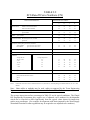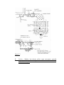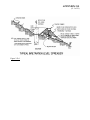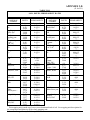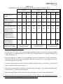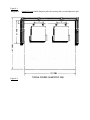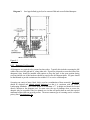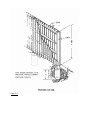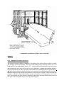
1
Table of Contents
Design Manual
Chapel Hill, North Carolina
SECTION 1. INTRODUCTION
1.1
1.2
PURPOSE
COMPLIANCE
SECTION 2. STORMWATER MANAGEMENT
2.1
2.2
2.3
2.4
2.5
2.6
INTRODUCTION
PERFORMANCE CRITERIA
Total Suspended Solids
Volume
Rate
Land Disturbance
HYDROLOGIC DESIGN
Hydrologic Methodology
SCS Method
Rational Method
INTEGRATED MANAGEMENT PRACTICES/BEST MANAGEMENT PRACTICES
Structural IMP’s/BMP’s
Non-structural IMP’s/BMP’s
STORMWATER IMPACT STATEMENT AND STORMWATER MANAGEMENT
PLAN CRITERIA
Application Submittal Checklist
DRAINAGE FACILITY DESIGN
Design Storms and Check Storms
Design Standards
Storm Drainage Pipe
Inlet Location and Spacing
Open Channels/Ditches
Curb and Gutter
Subsurface Drainage
APPENDIX 2-A
SCS Runoff Curve Method
APPENDIX 2-B
Rational Method
APPENDIX 2-C
Rational Runoff Coefficients
APPENDIX 2-D
General Design Criteria for Structural Level Spreaders
General Design Criteria for Buffers and Filter Strips
General Design Criteria for Infiltration Devices
General Design Criteria for Bio-retention Areas (Rain Gardens)
General Design Criteria for Detention/Retention/Re-use Facilities
General Design Criteria for Porous Pavement
General Design Criteria for Manufactured Products
APPENDIX 2-E
Design Manual Hydrology Technical Note
APPENDIX 2-F
Outlet Protection
APPENDIX 2-G
Stormwater Impact Statement and Stormwater Management Plan Guidelines
SECTION 3. LANDSCAPING AND TREE PROTECTION
3.1
3.2
3.3
3.4
DESIGN STANDARDS
Buffer Requirements
Parking Lot Requirements
PLANT SELECTION STANDARDS
Prohibited Invasive Exotic Species
Restricted species
Recommended Native Species
LANDSCAPE INSTALLATION AND MAINTENANCE SPECIFICATIONS
Materials Requirements
Soil Preparation
Planting Requirements
General Pruning Requirements
TREE PROTECTION STANDARDS
Tree Protection Ordinance Requirements
SECTION 4. ACCESS AND CIRCULATION
4.1
4.2
4.3
4.4
REQUIRED ACCESS
GENERAL STANDARDS
Relationship to Town Plans
Relationship to Surrounding Access Ways
Appropriate Speed
Vertical Alignment
Horizontal Alignment
Barriers
Intersections
Sight Line Triangles at Intersections
Dead-End Streets
STRUCTURAL STANDARDS
Phased Completion of Streets
TRAFFIC CONTROL DEVICES
4.5
EXTENSION AND COMPLETION OF ACCESS WAYS
Extension to Boundaries
Improvement of Substandard Access Ways
4.6
PUBLIC AND PRIVATE ACCESS WAYS
Public Access Ways
Private Access Ways Providing Required Access
NAMES, IDENTIFICATION AND ADDRESSES FOR PUBLIC AND PRIVATE
STREETS
Street Names
Street Name Signs
Street Addresses
MINIMUM STREET ELEVATIONS
GUARDRAILS AND BARRIERS
TRANSIT AMENITIES
BICYCLE PARKING
STREET CLASSIFICATION AND GEOMETRIC STANDARDS
BICYCLE PATHS
BICYCLE LANE
WORK ZONE TRAFFIC CONTROL
DISABILITY ACCESS
GROUNDCOVER WITHIN RIGHTS-OF-WAY
SOILS REPORT
APPENDIX 4-A
Street Classifications
Street Standards
Geometric Design Standards
4.7
4.8
4.9
4.10
4.11
4.12
4.13
4.14
4.15
4.16
4.17
4.18
SECTION 5. PARKING AND LOADING
5.1
5.2
5.3
OFF-STREET PARKING
Geometric Design
Pavement Standards
Parking Decks
Accessible Parking Spaces for the Handicapped
ON-STREET PARKING
LOADING SPACE REQUIREMENTS
SECTION 6. STREET LIGHTS, SIGNS AND MARKINGS
6.1
6.2
6.3
6.4
6.5
6.6
STREET LIGHTING APPLICABILITY
STREET LIGHTING PLAN SUBMITTAL REQUIREMENTS
STREET LIGHTING GUIDELINES
STREET LIGHT POLE & FIXTURE STANDARDS FOR RESIDENTIAL STREETS
STREET LIGHT PLACEMENT STANDARDS FOR RESIDENTIAL STREETS
STREET SIGNS AND MARKINGS APPLICABILITY
6.7
6.8
STREET SIGNS AND MARKINGS PLAN SUBMITTAL REQUIREMENTS
STREET SIGNS AND MARKINGS STANDARDS
SECTION 7. UTILITIES AND EASEMENTS
7.1
7.2
7.3
7.4
7.5
7.6
7.7
INTERRELATION OF UTILITY LINES
UNDERGROUND UTILITIES
SURFACE APPURTENANCES
SEWAGE COLLECTION SYSTEM
Provision for Future Service Areas
Design and Construction Standards and Materials
WATER DISTRIBUTION SYSTEMS
Provisions for Future Service Areas
Design and Construction Standards
Fire Hydrants
Location of Valves
AUTOMATIC SPRINKLER SYSTEMS
Non-Residential
Multi-family
Fraternity and Sorority Houses
EASEMENTS
SECTION 8. SOLID WASTE MANAGEMENT
8.1
8.2
8.3
8.4
8.5
RESIDENTIAL COLLECTION
Residential Refuse Collection Note
MULTI-FAMILY/COMMERCIAL/INSTITUTIONAL REFUSE COLLECTION
Recyclable Corrugated Cardboard Note
Dumpster Pad Design
Dumpster Pad Screening
Dumpster Placement and Access
Overhead Clearance
RESIDENTIAL RECYCLING
Residential Recycling Note
MULTI-FAMILY RECYCLING
Service Area Design
Service Area Access
COMMERCIAL/INSTITUTIONAL RECYCLING
Service Area Design
SECTION 9. APPEALS
SECTION 10. DESIGN MANUAL SUPPLEMENT
END
SECTION 1
INTRODUCTION
SECTION 1
1.1
INTRODUCTION
PURPOSE
These standards are meant to interpret and clarify the Development Ordinance Land Use
Management Ordinance and Design Guidelines of the Town of Chapel Hill.
The Town's land use and development policies, as embodied in the Comprehensive Plan, are
necessarily discussed in such broad terms as "livability", "Ppublic Ssafety", and "variety of housing
mix". The Comprehensive Plan contains community-wide goals and objectives which emphasize
the existing character of the Town and its neighborhoods. The Development Ordinance Land Use
Management Ordinance and Design Guidelines deal with the more specific concepts such as types
of use, lot sizes, parking requirements and the like.
However, even these more specific terms can be interpreted in a variety of ways, especially where a
specific development in a specific location is being considered. Therefore, the Town of Chapel Hill
Design Manual has been prepared to help people involved with land development in Chapel Hill and
its planning jurisdiction to understand, before they begin, what will most likely be acceptable in this
jurisdiction. These standards are intended to complement and supplement the general Design
Guidelines included in the Comprehensive Plan.
Specific design criteria set forth herein provide a ready reference of those practices and techniques
acceptable to the Town. We also encourage design professionals to consider site characteristics
closely in their design and to seek new and better practices and techniques for complying with Town
development policies and regulation. If, in response to the characteristics of a particular site,
innovative practices, and/or technological changes, a designer can make a valid case for application
of standards that modify or substitute for the design standards contained herein, he or she is
encouraged to do so.
Where alternative standards can be shown to conform with applicable policies and regulations, the
Town may accept such alternative standards in lieu of the standards contained herein. Similarly,
where a particular site is characterized by a large number or extent of impediments to developing
land in compliance with applicable policies and standards, or where technological changes provide
for practices and techniques that better ensure compliance, the Town itself may modify or substitute
additional standards for the design standards contained herein.
These standards include deadlines for improvements. The Manager may allow extensions of
deadlines provided these extensions: (1) will not conflict with the intent of these standards and other
land development regulations and; (2) include a practical justification for an extension.
1.2.
COMPLIANCE
Compliance with these standards shall be required at the time property is developed, whenever a
major increase in the intensity of use is created as determined by the Town Manager, or whenever a
use group change occurs from Use Group A to B or C or from Use Group B to C, as outlined in the
Town of Chapel Hill Development Ordinance Land Use Management Ordinance.
The following shall be exempted from these requirements:
a)
any development of a single- or two-family dwelling on a zoning lot, or any uses accessory
thereto;
b)
any development or detailed plan pursuant to a Special Use Permit, site plan or Certificate
of Appropriateness approved prior to the adoption of these standards.
c)
any development that, in the opinion of the Town Manager, does not significantly affect
traffic circulation, drainage, relationship of buildings to each other, landscaping, buffering,
or lighting.
The Town Manager may exempt modifications to existing developments from individual provisions
of these standards where, in the opinion of the Town Manager, compliance with those provisions
would create a practical hardship upon the property owner and where the modification does not
increase the a nonconformity.
The Design Manual and Standard Details will be updated as necessary, and the revised pages will be
available from the Town of Chapel Hill Engineering Department and on the Town web site at
http://www.townofchapelhill.org.
SECTION – 2
STORMWATER
MANAGEMENT
SECTION 2
STORMWATER MANAGEMENT AND DRAINAGE
A.
HYDROLOGIC DESIGN
2.1
INTRODUCTION
Development and re-development within the Chapel Hill Planning Jurisdiction is required to
manage stormwater in accordance with Article 5.4 of the Chapel Hill Land Use Management
Ordinance. This section of the Design Manual provides information on the design and
application of acceptable means and measures to comply with the requirements of the Ordinance.
The Ordinance requires that development and re-development activities properly manage and
control stormwater runoff rate, volume, pollutants, and erosion/sedimentation as necessary to
protect and safeguard the environment, property, health, safety and welfare of citizens within
the Town’s jurisdiction.
Low-Impact Design (LID)using integrated/best management practices is encouraged to meet the
stormwater management performance criteria in the Land Use Management Ordinance.
Acceptable stormwater management practices include those found in this Design Manual and in
the most recent addition of the North Carolina Division of Water Quality Stormwater Best
Management Practices Manual. The Town reserves the right to modify, amend or otherwise
change these accepted practices as may be necessary to achieve stated stormwater management
goals.
Considerations in selecting and using stormwater management means and measures for a
specific development will include, but are not limited to: site applicability, public safety, spatial
requirements, soil characteristics, hydrologic benefits, slope, existing land use conditions,
maintenance requirements, location within the watershed, overlay districts, buffer requirements,
tree protection, easements, etc. As a part of the development permit application process,
conceptual methods and designs outlined in the Stormwater Management Plan and
accompanying Stormwater Impact Statement (Appendix 2-G) must be submitted to the Town for
comprehensive review, evaluation, optimization and approval. Revisions in the plan may be
necessary to obtain Town approval.
B.
HYDROLOGIC DESIGN
2.2
PERFORMANCE CRITERIA
2.2.1 Total Suspended Solids - Stormwater treatment shall be designed to achieve average
annual 85% Total Suspended Solids (TSS) removal and must apply to the volume of postdevelopment runoff resulting from the first 1-inch of precipitation. Alternative treatment
methods to achieve 85% average annual TSS removal may be acceptable.
2.2.2 Volume - The post-development stormwater runoff volume leaving the site shall not
exceed the pre-development (existing conditions) stormwater runoff volume leaving the site for
the local 2-year frequency, 24-hour duration storm event for all development, except singlefamily and two-family dwellings, on lots existing as of January 27, 2003 or on lots created
pursuant to a Preliminary Plat that was approved by the Town Council prior to January 27, 2003.
This criterion can be achieved by hydrologic abstraction, recycling, reuse, or any other accepted
scientific method.
2.2.3 Rate - The post-development stormwater runoff rate leaving the site shall not exceed the
pre-development (existing conditions) stormwater runoff rate leaving the site for the local 1year, 2-year, and 25-year 24-hour storm events.
2.2.4 Land Disturbance - Disturbance of any stream channel shall be prohibited unless
explicitly authorized by issuance of a Zoning Compliance Permit after demonstration of the
necessity for the disturbance. If stream channel disturbance is authorized, it shall be minimized
to the extent practicable.
2.3
HYDROLOGIC DESIGN
Design Storms
Hydrologic design includes evaluation of the impacts that development has on stormwater
runoff. The evaluation involves selecting the required design storm (Table 2.1) and using
accepted hydrologic methodology to design storm drainage infrastructure, stream crossings,
detention/retention facilities, etc. as necessary to meet applicable requirements and the
performance standards of the Town’s Land Use Management Ordinance. adjacent to some
facilities during times of peak runoff. Designers must evaluate the impacts of such temporary
impoundmen proposed stormwater management practices both on-site and on nearby adjacent
properties, structures, and roadways.
Table 2.1 lists return periods for determining design storm and check storm discharges for
different types of facilities.in Chapel Hill The check storm analysis should indicate that
surcharge or overflow discharges will be conveyed in a controlled manner that will not cause a
public health or safety risk.
TABLE 2.1
DESIGN and CHECK STORMS
Land Use Facility
Design Storm
(SCS 24-hour duration)
Check Storm
(SCS 24-hour duration)
Arterial Roadways
25 yr.
50 yr.
Collector Roadways
25 yr.
50 yr.
Local Roadway
10 yr.
25 yr.
Parking Lots
10 yr.
25 yr.
Open Channels
25 yr.
50 yr.
Bridges/Box Culverts/Stream
50 yr.
100 yr.
1 yr., 2-yr. and 50 25-yr.
100 yr.
10 yr.
25 yr.
Crossings *
Detention/Retention/Infiltration
Facilities**
Buildings
*
For Regulatory Floodways, the Design Storm is the 100-year return period and the
Resource Conservation District provisions must be met.
**
Facilities may be designed to meet multiple stormwater management performance criteria
Note: Where conflicts exist between applicable State and Town design storm requirements, the
more restrictive of the two shall govern
2.3.1
Hydrologic Methodology
Hydrology deals with the occurrence and movement of water upon and beneath the land. In
Chapel Hill the recognized methods for determining the relationship between rainfall and runoff:
are the Rational Method, HEC-1, HEC-HMS. USDA TR-55 or other methods approved by the
Town Manager.
Hydrologic methodology includes estimating peak runoff rates, volumes and time distributions
(discharge per unit of time) as a result of precipitation. The most commonly recognized methods
for determining the relationship between rainfall and runoff are the SCS Method and the
Rational Method. .Other analytical tools may be approved by the Town Manager if properly
substantiated. The SCS Method and Rational Method are described below. (See APPENDIX 2E,
Design Manual Hydrology Technical Note.)
(a)
SCS Method
For the SCS Curve Number method, peak discharge and volume calculations shall be based on a
Type II precipitation distribution and total runoff depth using SCS equations, curves, and the
appropriate depth-duration-frequency and intensity-duration-frequency tables provided in
Appendix 2-A.
(1)
Hydrologic Soil Group
Soils properties influence the relationship between rainfall and runoff by affecting
the rate of infiltration. Soils have been divided into four hydrologic soil groups
based on infiltration rates as noted in Table 2.2. These soil groups are used in
conjunction with land use descriptions to determine runoff curve numbers.
(2)
Land Use
Types of land use within a given watershed affect hydrology and runoff
characteristics. Table 2.2 includes land use descriptions used to determine curve
numbers. Things Uses such as vegetation, water surfaces, roads, roofs, parking
lots, etc. are all types of land uses. which relate to hydrology. Each affects the
relation between rainfall and runoff.
(3)
Curve Numbers
Both soil groups and land use determine applicable runoff curve numbers for use
in hydrologic modeling. Table 2.2 includes runoff curve numbers for different
land uses within specific soil groups.
TABLE 2.2
SCS Runoff Curve Numbers (CN)
LAND USE DESCRIPTIONS
HYDROLOGIC SOIL GROUP
A
B
C
D
72
62
81
71
88
78
91
81
Pasture or range land: poor condition
good condition
68
39
79
61
86
74
89
80
Meadow: good condition
30
58
71
78
Wood or forest land: thin stand, poor cover, no mulch
good cover
45
25
66
55
77
70
83
77
Open Spaces, lawns, parks, golf courses, cemeteries
good condition:
grass cover on 75% or more
fair condition:
grass cover on 50% to 75%
39
49
61
69
74
79
80
84
Commercial and business areas (85% impervious)
89
92
94
95
Industrial districts (72% impervious)
81
88
91
93
77
61
57
54
51
85
75
72
70
68
90
83
81
80
79
92
87
86
85
84
Paved parking lots, roofs, driveways, etc.
98
98
98
98
Streets and roads:
paved with curbs and storm sewers
gravel
dirt
98
76
72
98
85
82
98
89
87
98
91
89
Cultivated land:
without conservation treatment
with conservation treatment
Residential:
Average lot size
1/8 acre or less
¼ acre
1/3 acre
½ acre
1 acre
Source:
Average: Impervious
65
38
30
25
20
USDA Soil Conservation Service Technical Release N. 55 (SCS-TR-55), "Urban Hydrology for Small Watersheds", Jan. 1971 SCS
Method
Note: Other tables or methods may be used, subject to approval by the Town Engineering
Department, to determine SCS Curve Numbers and/or Rational Coefficients.
The average impervious surface percentages in Table 2.2 are for typical conditions. The Chapel
Hill Engineering Department may require use of adjusted curve numbers for developments
which can be expected to differ significantly from the typical values shown for impervious
surface area percentages. (For example, developments with limits imposed by the Water Supply
Watershed Protection or other regulations may be required to use adjusted curve numbers.)
Stormwater Release Rate Criteria
The peak discharge rate for the post-developed conditions shall be no greater than the peak
discharge rate for the pre-developed conditions for the 1-year, 24-hour duration (3.00") and the
50-year, 24-hour duration (7.20") return period storms. Acceptable methodologies for
calculating peak flow rates include: The Rational Method, HEC-1 or HEC-HMS methods,
USDA TR-55 or other methods as approved by the Manager. For the 1-yr. storm intensity
calculation, contact the Town Stormwater Management Engineer.
Depending on the development site location, size in area and the condition of the existing
conveyance system and associated lands, the Manager may waive the peak discharge rate criteria
in part or in whole if, based on an approved Stormwater Impact Statement, it is demonstrated
through hydrographs or other methods that there would be no definitive negative impact(s)
and/or that discharge rate controls would increase existing flooding, or other problems on
abutting or downstream properties.
Stormwater BMP Criteria
Developments shall utilize stormwater best management practices (BMP's), as approved by the
NC Division of Water Quality (NCDWQ) and the Town Manager, to adequately treat
stormwater runoff from all built-upon, impervious areas for a development, as defined in the
Town Development Ordinance equal to or exceeding 20,000 square feet in area. The goal shall
be to remove 85% of the average annual total suspended solids (TSS) from the post-developed
conditions stormwater runoff or meet the minimum North Carolina stormwater management
rules. See the NCDWQ Stormwater BMP Manual (latest) or contact the Town Stormwater
Management Engineer. If the development is less than 20,000 square feet in area, it is
recommended that stormwater BMP’s be utilized to the extent practicable. Submit proposal(s)
or alternatives for BMP's to the Town Stormwater Management Engineer for review.
For the SCS Curve Number method, peak discharge and volume calculations shall be based on a
Type II precipitation distribution and total runoff depth using SCS equations, curves, and the
appropriate depth-duration-frequency and intensity-duration-frequency tables provided in
Appendix 2-A.
(b)
Rational Method
For catchments up to and including 25 acres, the Rational Method may be used to calculate peak
discharges for 1-yr, 2-yr & 25-yr storm events, unless site specific circumstances dictate that
hydraulic routing and hydrograph generation are necessary.
The following procedure should be followed for Rational Method analyses:
(1)
(2)
Determine the watershed size in acres (A) to the point of discharge.
Calculate the time of concentration (Tc) using the equations found in Appendix
2-B.
(3)
Determine the rainfall intensity (I) using the appropriate intensity-durationfrequency table found in Appendix 2-A. NOTE: For the 1-yr.storm, use 80% of
the 2-year storm peak discharge, or the following equation, to calculate intensity:
I= g/(h+T) where:
I= rainfall intensity in inches per hour
G= 104 (empirically derived constant)
H= 18 (empirically derived constant)
T= rainfall duration in minutes or time of concentration in minutes
2.4
(4)
Determine the composite runoff coefficient (C) using the table found in Appendix
2-C.
(5)
Apply the Rational Equation Q=CIA for the applicable pre/post-development
condition and storm frequency.
INTEGRATED
MANAGEMENT
PRACTICES (IMP/BMP’S)
PRACTICES/BEST
MANAGEMENT
Development applicants shall utilize stormwater “Integrated Management Practices and/or “Best
Management Practices” (IMP/BMP's) to the extent practicable and as approved by the Town
Manager. The Town encourages the use of low impact design techniques to manage stormwater
runoff as close as possible to its source.
The selection and use of the IMP/BMP’s for a specific development will vary depending upon a
variety of factors including: site characteristics, public safety, spatial requirements, soil
characteristics, hydrologic characteristics, slope,
land use considerations, maintenance
requirements, location within the watershed, overlay districts, buffer requirements, tree
protection requirements, easements, etc.
The following structural and non-structural stormwater management practices may be used
individually or in combination to meet the performance criteria established by the Town. Other
stormwater management practices and facilities will be considered on a site specific basis,
subject to approval by the Manager.
2.4.1
Structural IMP/BMP’s:
(a) Functional Techniques
Structural IMP/BMP’s are commonly used to meet stormwater runoff volume, peak discharge,
and water quality performance criteria. The following information describes functional
techniques typically associated with structural IMP/BMP’s:
(1)
Diffuse Flow - describes stormwater runoff that is conveyed in shallow unconcentrated flow at velocities that do not cause scour. Diffuse flow is typically
created by uniformly and moderately sloped surfaces, often in conjunction with
the installation of a level spreader device to evenly disperse concentrated runoff
flows. Diffuse flow through a vegetated buffer (such as wooded areas) will often
achieve significant removal of suspended solids.
Figure 2.1: Filter Strip
(2)
Infiltration - refers to the process whereby stormwater enters the soil, typically
converting from surface flow (runoff) to sub-surface flow. Infiltration of
stormwater may occur naturally and/or via devices that supplement and enhance
the natural infiltration process.
(3)
Detention - involves the temporary storage and slow release of stormwater runoff.
The slow release shouldoccur over a period of 2 to 5 days, with 3 days (72 hours)
recommended. Detention facilities shall be designed to fully drain to a normally
dry condition.
(4)
Retention - involves both permanent and temporary storage of stormwater runoff.
Retention facilities include a permanent pool with an additional area (volume)
available to temporarily store stormwater runoff. The temporary storage area
should be designed to slowly release its stored volume over a period of 2 to 5
(5)
days. Retention facilities shall be designed to release only the temporary storage
volume, and to retain the permanent pool volume.
Re-use - involves capturing stormwater runoff and using it for appropriate nonpotable purposes (such as non-food crop irrigation, equipment cooling/washing,
toilet flushing, etc.).
(b) Facility Types and Descriptions
(1)
(2)
Diffuse flow
A.
Level spreaders – Constructed devices designed to convert concentrated
flow to diverse flow.
B.
Uniformly graded/moderately sloped conveyances – Designed to
minimize concentration of runoff flow.
C.
Vegetated buffers – Natural or planted areas that will spread and reduce
velocity of overland flow.
Infiltration
A.
Dry Wells/French Drains – Sump and/or trenches filled with high void
ratio material such as uniformly graded gravel and sometimes including a
perforated pipe under-drain system.
Figure 2.2
B.
Swales – Shallow, low-velocity surface water conveyance, typically
grassed, that allows slow-moving water to infiltrate into the surrounding
soil as it is conveyed.
Figure 2-2.1 – A Typical Infiltration Swale
C.
Bio-retention Areas/Rain Gardens – A relatively shallow, landscaped
depression designed to receive and detain stormwater runoff flows, thus
allowing for infiltration and removal of suspended solids/pollutants.
D.
Infiltration Detention Facility - A variable depth, engineered facility
typically including a forebay to intercept waterborne sediment. Release
rate is controlled to facilitate water infiltration into the surrounding soils.
E.
Soil Amendment - includes tilling and amending existing soil with sandy
loam to increase permeability
F.
Porous Pavement - Asphalt and concrete pavement specifically designed
and placed with a high void ratio to create a permeable surface. Base
materials are typically engineered to provide both support and storage
capacity for water passing through the porous pavement. Mix designs and
placement guidelines are available although the Carolina Ready-Mix
Concrete Association, the U.S.D.O.T Federal Highway Administration,
and the Asphalt Institute among others.
(NOTE: For Rational Method runoff coefficient (c) use 0.10; for SCS
runoff Curve Number use 50.).
Figure 2.3
G.
(3)
Green Roofs - Roof areas covered with soil material and vegetation
intended to absorb rainfall and re-use it to support the rooftop vegetation.
Detention, Retention, and Re-use Facilities
A
Detention Facilities - Include above or below ground facilities designed to
collect and detain stormwater runoff, and to release the water slowly until
the facility is dry (i.e. no permanent pool).
B
Retention Facilities - Are above ground facilities designed with a
permanent pool and additional runoff storage area (free-board above the
permanent pool elevation) from which the stored volume of water can be
released at a controlled rate.
C.
Re-use Facilities – Above-ground or under-ground facilities that capture
and store stormwater runoff for non-potable uses such as non-food crop
irrigation, equipment cooling/washing, toilet flushing, etc.
(c) Facility General Design Criteria and Illustrations
Appendix 2-D includes design information and illustrations for a variety of stormwater
management control devices.
2.4.2
Non-structural IMP/BMP’s
Non-structural IMP/BMP’s include Low Impact Design practices that minimize alterations to the
existing hydrology. These practices include minimizing the amount of land area and vegetation
disturbance, minimizing impervious surface area, and eliminating direct storm sewer discharges
into receiving streams.
2.5
STORMWATER
IMPACT
STATEMENT
MANAGEMENT PLAN CRITERIA
AND
STORMWATER
A Stormwater Impact Statement and Stormwater Management Plan are typically required as part
of Zoning Compliance Permit, Site Plan Review, Preliminary Plat, and Special Use Permit
applications, in accordance with the the Land Use Management Ordinance. Stormwater Impact
Statement Guidelines can be found in Appendix 2-G. These guidelines provide specific
information regarding preparation and submittal of Stormwater Impact Statements.
2.5.1
Application Submittal Checklist
The following information shall be submitted to the Town for review and approval prior to
issuance of a:
Zoning Compliance Permit or Special Use Permit
• Stormwater Impact Statement
• Stormwater Management Plan
• Storm Drainageway Easements on plat and plan;
Certificate of Occupancy
• Engineer’s Certification and as-built
• Operations & Maintenance Plan
• Recorded Deed
a. Narrative of site characteristics including topography, land use, and impervious surface area
for both pre-developed (existing) conditions and post-developed conditions off-site drainage
conditions, location and condition of existing drainage infrastructure and streams, Resource
Conservation District and regulatory floodplain information, other information deemed
appropriate by the design engineer.
b. Peak discharge calculations (1-yr. & 50-yr., 24-hour duration storm event) using accepted
hydrologic methodology including but not limited to Rational Method, HEC-HMS, HEC-1, and
USDA TR-55.
c. Pollutant loading calculations in accordance with Table 1 in the SWIS Guidelines (latest).
d. Proposed mitigation measures for increases associated with Items b. & c. above.
e. Impacts on abutting or downstream properties, depending on the site location, runoff
characteristics and the condition of the existing conveyance system and associated lands.
Operations and Maintenance Plan
Submittal of an acceptable Operations and Maintenance Plan is required prior to final plan
approval for all engineered stormwater facilities being proposed as part of a development.
Reserved Storm Drainageway Easement
A. Conveyance systems, stormwater structures, stormwater detention and treatment structures
shall be located within an easement entitled: "Reserved Storm Drainageway Easement Hereby
Dedicated" and shall be reserved from any development which would obstruct or constrict the
effective conveyance and control of stormwater from or across the property. Internal collection
and conveyance systems on private property, which deal only with internal stormwater runoff, do
not require drainageway easements.
B. The "Reserved Storm Drainageway" shall be defined on the appropriate final plan sheet(s)
and recorded on the final plat.
Unless specifically designated as being "Public" a "Reserved Storm Drainageway Easement" and
the facilities it protects are considered to be private, with the sole responsibility of the owner to
provide for all required maintenance and operations as approved by the Town Manager.
C. The minimum width of the Reserved Storm Drainageway Easement shall be 30 feet unless
otherwise approved by the Town Manager.
D. Maintenance access to stormwater detention and treatment structures shall be provided and
shown on the plans.
DESIGN OF CULVERTS
2.6
DRAINAGE FACILITY DESIGN
For the purposes of this section manual, “drainage facilities” include engineered infrastructure
designed to safely and effectivelycarry receive, convey, and discharge stormwater runoff within
Town’s planning jurisdiction. Drainage facilities must be designed to control/convey stormwater
runoff resulting from all storm events up to and including the design storm and check storm as
noted in Table 2-1.
2.6.1
Design Storms and Check Storms
The 10 year design storm and 25 year check storm shall be used for design of stormwater
management infrastructure on Local Streets. The 25 year design storm and 50 year check storm
shall be used for design of stormwater management infrastructure on Collector and Arterial
Streets. All streets crossing perennial or intermittent streams must comply with the Land Use
Management Ordinance regulations regarding development in the Resource Conservation
District.
2.6.2
Design Standards
The stormwater management and storm drainage infrastructure shall be designed such that:
•
Streets will not be flooded as a result of stormwater runoff from the applicable design
storm.
•
Backwater will not exceed the boundaries of storm drainage easements or rights-ofway.
•
Structures and/or property located outside of drainage easements or regulatory
floodplains will not be flooded.
•
The maximum stormwater spread widths allowed in Table 2-3 are not exceeded for
the applicable street classification.
TABLE 2.3
MAXIMUM ALLOWABLE STORMWATER SPREAD ON PAVEMENT
STREET CLASSIFICATION
MAXIMUM ALLOWABLE SPREAD
LOCAL
No curb over-topping,* flow spread must leave
at least one lane free of water
COLLECTOR AND ARTERIAL
No curb over-topping*, flow spread must leave
at least one lane in each direction free of water.
* Where no curbing exists, spread shall not extend outside of the public right-of-way.
(Reference: Wright-McLaughlin Engineers)
•
Surface flow and channel velocities do not exceed 4 feet per second for the applicable
design storm.
•
There is no surcharging in the drainage system for the applicable design storm.
(Hydraulic grade lines or grades must be calculated to demonstrate the efficiency of
the storm drain system and as a check to ensure that there is no surcharging in the
system.)
(a)
Hydraulic Efficiency: Determining the hydraulic efficiency of a culvert requires
calculation of three energy losses: an understanding of inlet losses (resulting from the shape and
alignment of the entrance to a culvert), outlet losses (resulting from the change in cross-sectional
area at the outlet of a culvert), and friction losses (resulting from resistance to flow within a
culvert).
Culvert design may require the calculation of the hydraulic grade line to ensure surcharge
protection.
1
The inlet control analysis evaluates the capacity of a culvert is controlled at its
entrance considering the depth of headwater, type of inlet, and the entrance shape.
The headwater depth is the vertical distance from the culvert invert at the
entrance to the headwater pool surface. The roughness, length and outlet
conditions of the culvert are not factors in an inlet control analysis.
2
The outlet control analysis evaluates the capacity of a culvert is considering all
hydraulic factors upstream from the outlet. These hydraulic factors include the
culvert shape, length, slope, and roughness, and the depth of water at the culvert
outlet. Friction losses are part of the outlet control analysis.
Culvert End Treatments are intended to provide protection against excessive are an important
consideration when designing culverts scour at inlets and outlets. Chapel Hill requires that either
a End treatments typically include flared end sections and/or headwalls. Table 2-4 lists inlet
coefficients (Ke) for different entrance conditions and structure types.
Refer to Appendix 2-F for technical information.
TABLE 2.4
INLET COEFFICIENTS
Outlet Control, Full or Partly Full
Entrance head loss He = Ke v2
2g
Type of Structure and Design of Entrance
Coefficient Ke
Pipe, Concrete
Projecting from fill, socket end (groove-end)...................
Projecting from fill, sq. cut end ........................................
Headwall or head wall and wingwalls
Socket end of pipe (groove-end)..........................
Square-edge .........................................................
Rounded (radius = 1/12D) ...................................
Mitered to conform to fill slope ........................................
*End-section conforming to fill slope...............................
Beveled edges, 33.7° or 45° bevels...................................
Side or slope-tapered inlet ................................................
0.2
0.5
0.2
0.5
0.2
0.7
0.5
0.2
0.2
Pipe, or Pipe-Arch, Corrugated Metal
Projecting from fill (no headwall).....................................
Headwall or headwall and wingwalls square-edge ...........
Mitered to conform to fill slope, paved or unpaved
slope ................................................................................
*End-Section conforming to fill slope..............................
Beveled edges, 33.7° or 45° bevels...................................
Side or slope-tapered inlet ................................................
0.9
0.5
0.7
0.5
0.2
0.2
Box, Reinforced Concrete
Headwall parallel to embankment (no wingwalls)
Square-edge on 3 edges .......................................
Rounded on 3 edges to radius of 1/12 barrel
dimension, or beveled edges on 3 sides ...............
Wingwalls at 30° to 75° to barrel
Square-edge at crown...........................................
Crown edge rounded to radius of 1/12 barrel
dimension, or beveled top edge ..........................
Wingwall at 10° to 25° to barrel
Square-edged at crown.........................................
Wingwalls parallel (extension of sides)
Square-edged at crown.........................................
Side or slope-tapered inlet ................................................
0.5
0.2
0.4
0.2
0.5
0.7
0.2
*Note: "End Section conforming to fill slope", made of either metal or concrete, are the sections
commonly available from manufacturers. From limited hydraulic tests they are equivalent in
operation to a headwall in both inlet and outlet control. Some end sections, incorporating a
closed taper in their design have a superior hydraulic performance.
Outlet Protection must be provided as necessary to dissipate energy and to create diffuse flow at
the outlet ends of conveyance structures. Outlet protection measures include installation of rockreinforced aprons, stilling basins, level spreaders, sump or other approved methods. (Refer to
APPENDIX 2-F for further information)
Evaluation of flow conditions, scour potential, and channel erosion should be included in
standard design analyses. The initial protection against channel erosion should be sufficient to
minimize the impacts of a single storm event. Stilling basin and level spreader installations are
preferred means of energy dissipation. The use of local rock is preferred in lieu of quarried riprap for the construction of energy dissipating rock aprons and stilling basins. This Design
Manual provides the minimum dimensions for rock aprons and stilling basins at storm drainage
outlets. However, existing conditions at the outlet and scour potential may dictate the
installation of outlet protect measures in excess of the minimum requirements.
2.6.3
Storm Drainage Pipe:
The following criteria apply to storm drainage pipes under public streets, within public rightsof-way, and/or within public drainage easements.
2.6.4
•
All storm drainage pipes shall be Class III or greater reinforced concrete pipe.
•
The minimum pipe size is 15-inch inside diameter.
•
Flared-end sections may be used with pipes 36-inch or less in diameter.
•
End walls shall be provided for pipes with diameters larger than 36 inches unless
alternative end treatments are approved by the Town Manager.
•
The minimum cover for drainage pipes is 2 feet unless otherwise approved by the
Town Manager..
•
The minimum pipe grade is 2% for storm drainage pipes 36-inches or less in
diameter. Flatter grades may be accepted by the Town for larger diameter pipe
provided that it can be demonstrated that the design pipe grade provides for a selfcleaning velocity of 3 feet per second when the pipe is flowing half-full.
•
The maximum pipe length without installation of a catch basin, curb inlet or junction
box is 400 feet.
Inlet Location and Spacing
Inlets should be placed at intersections and all low points in the gutter grade to prevent gutter
flow from crossing traffic and pedestrian lanes of the intersecting road. (Refer to Table 2.3
Maximum Allowable Stormwater Spread.) Inlets are normally placed upstream of pedestrian
crossings to intercept the gutter flow before it reaches the crosswalk. Where pavement surfaces
are warped, as at cross streets, ramps, or transitions between supereleavated and normal sections,
gutter flow should be diverted into the storm drainage system to prevent water flow across the
roadway. Where a curbed roadway crosses a bridge,gutter flow should be intercepted before it
reaches the bridge.
Runoff from areas adjacent to streets should be intercepted before reaching the pavement. This
applies to water that would normally run onto the street from side streets or from cut slopes and
areas along the edge of pavement. A minimum of two inlets (double inlet) should be placed in
the sag of vertical curves. The additional inlets provide extra capacity and a safety factor against
potential street flooding if the inlets become clogged due to deposition of sediment and debris.
Inlets on a continuous grade should be spaced to limit the spread of stormwater onto the
pavement. The spacing of inlets is based on the allowable spread and the inlet capacity. The
flow bypassing an inlet must be included in the flow arriving at the next inlet.
2.6.5
Open Channels/Ditches
For maintenance and stability reasons, the maximum side-slope for open channels is 3:1. The
channel protection required to prevent erosion is determined by computing the velocity in the
channel at the design discharge and comparing that velocity with the permissible value for the
type of channel lining used.
2.6.6
Curb & Gutter
Standard 30 inch curb-and-gutter is required in all cases, unless an alternative is approved by the
Town Manager. The minimum longitudinal grade for curb & gutter is 2%. Spot grades or
profiles shall be provided in cul-de-sacs to ensure positive drainage.
2.6.7
Subsurface Drainage
The installation of subsurface drainage measures may be required to protect against inundation
of subgrade materials when landscaped and/or irrigated areas are constructed adjacent to streets
or sidewalks. See the following illustration of typical subsurface drain that may be required.
The Town of Chapel Hill Engineering Department Stormwater Design Handbook contains
additional and specific information regarding a variety of design issues concerning stormwater
management and drainage. Copies of this handbook are available in the Chapel Hill Engineering
Department.
Figure 2.4
APPENDIX 2-A
(P. 1 of 7)
SCS Runoff Curve Number (CN) method
The SCS Runoff Curve Number (CN) method is described in detail in NEH-4 (SCS 1985).
The SCS runoff equation is
Q = (P – Ia)2 / (p – Ia) + S
[Eq. 2-1)
Where
Q = runoff (in),
P = rainfall (in),
S = potential maximum retention after runoff begins (in), and
1a = initial abstraction (in).
Initial abstraction (Ia) is all losses before runoff begins. It includes water retained in surface
depressions, water intercepted by vegetation, evaporation, and infiltration. Ia is highly
variable but generally is correlated with soil and cover parameters. Through studies of
many small agricultural watersheds, Ia was found to be approximated by the following
empirical equation:
Ia = 0.2S.
[Eq. 2-2]
By removing Ia as an independent parameter, this approximation allows use of a
combination of S and P to produce a unique runoff amount. Substituting equation 2-2 into
equation 2-1 gives
Q = (P – 0.2S)2 / (P + 0.8S)
[Eq. 2-3]
S is related to the soil and cover conditions of the watershed through the CN. CN has a
range of 0 to 100, and S is related to CN by
S = (1000/CN) - 10.
[Eq. 2-4]
Figure 2-1 and table 2-1 solve equations 2-3 and 2-4 for a range of CN’s and rainfall.
Factors considered in determining runoff curve numbers
The major factors that determine CN are the hydrologic soil group (HSG), cover type,
treatment, hydrologic condition, and antecedent runoff condition (ARC). Another factor
considered is whether impervious areas outlet directly to the drainage system (connected) or
whether the flow spreads over pervious areas before entering the drainage system
(unconnected). Table 2-A-1 is provided to aid in selecting the appropriate figure or table for
determining curve numbers.
APPENDIX 2-A
(P. 2 of 7)
CN’s in table 2-2 (a to d) represent average antecedent runoff condition for urban, cultivated
agricultural, other agricultural, and arid and semiarid rangeland uses. Table 2-2 assumes
impervious areas are directly connected. The following sections explain how to determine
CN’s and how to modify then for urban conditions.
Hydrologic soil groups
Infiltration rates of soils vary widely and are affected by subsurface permeability as well as
surface intake rates. Soils are classified into four HSG’s (A, B, C, and D) according to their
minimum infiltration rate, which is obtained for bare soil after prolonged wetting. Appendix
A defines the four groups and provides a list of most of the soils in the United States and
their group classification. The soils in the area of interest may be identified from a soil
survey report, which can be obtained from local SCS offices or soil and waer conservation
district offices.
Most urban areas are only partially covered by impervious surfaces: the soil remains an
important factor in runoff estimates. Urbanization has a greater effect on runoff in
whatersheds with soils having high infiltration rates (sands and gravels) than in watersheds
predominantely of silts and clays, which generally have low infiltration rates.
Any disturbance of a soil profile can significantly change its infiltration characteristics.
With urbanization, native soil ; profiles may be mixed or removed or fill material from other
areas may be introducted. Therefore, a method based on soil texture is given in appendix A
for determining the HSG classification for disturbed soils.
Cover type
Table 2-2 addresses most cover types, such as vegetation, bare soil, and impervious
surfaces. There are a number of methods for determining cover type. The most common
are field reconnaissance, aerial photographs, and land use maps.
Treatment
Treatment is a cover type modifier (used only in table 2-2b) to describe the management of
cultivated agricultural lands. It includes mechanical practices, such as contouring and
terracing, and management practices, such as crop rotations and reduced or not tillage.
Hydrologic condition
Hydrologic condition indicates the effects of cover type and treatment on infiltration and
runoff and is generally estimated from density of plant and residue cover on sample areas.
Good hydrologic condition indicates that the soil usually has a low runoff potential for that
specific hydrologic soil group. Cover type, and treatment. Some factors to consider in
estimating the effect of cover on infiltration and runoff are (a) canopy or density of lawns,
crops. Or other vegetative areas; (b) amount of year-round cover; (c) amount of grass or
close-seeded legumes in rotations; (d) percent of residue cover; and (e) degree of surface
roughness.
APPENDIX 2-A
(P. 3 of 7)
Table 2-A-1 – Runoff depth for selected CN’s and rainfall amounts1
Runoff depth for curve number of –
Rainfall
1.0
1.2
1.4
1.6
1.8
2.0
2.5
3.0
3.5
4.0
4.5
5.0
6.0
7.0
8.0
9.0
10.0
11.0
12.0
13.0
14.0
15.0
40
45
50
55
60
65
70
75
80
85
90
95
98
-----------------------------------------------------------------------inches------------------------------------------------------0.00
0.00
0.00
0.00
0.00
0.00
0.00
0.03
0.08
0.17
0.32
0.56
0.79
.00
.00
.00
.00
.00
.00
.03
.07
.15
.27
.46
.74
.99
.00
.00
.00
.00
.00
.02
.06
.13
.24
.39
.61
.92
1.18
.00
.00
.00
.00
.01
.05
.11
.20
.34
.52
.76
1.11
1.38
.00
.00
.00
.00
.03
.09
.17
.29
.44
.65
.93
1.29
1.58
.00
.00
.00
.02
.06
.14
.24
.38
.56
.80
1.09
1.48
1.77
.00
.00
.02
.08
.17
.03
.46
.65
.89
1.18
1.53
1.96
2.27
.00
.02
.09
.19
.33
.51
.71
.95
1.25
1.59
1.98
2.45
2.77
.02
.08
.20
.35
.53
.75
1.01
1.30
1.64
2.02
2.45
2.94
3.27
.06
.18
.33
.53
.76
1.03
1.33
1.67
2.04
2.46
2.92
3.43
3.77
.14
.30
.50
.74
1.02
1.33
1.67
2.05
2.46
2.91
3.40
3.92
4.26
.24
.44
.69
.98
1.30
1.65
2.04
2.45
2.89
3.37
3.88
4.42
4.76
.50
.80
1.14
1.52
1.92
2.35
2.81
3.28
3.78
4.30
4.85
5.41
5.76
.84
1.24
1.68
2.12
2.60
3.10
3.62
4.15
4.69
5.25
5.82
6.41
6.76
1.25
1.74
2.25
2.78
3.33
3.89
4.46
5.04
5.63
6.21
6.81
7.40
7.76
1.71
2.29
2.88
3.49
4.10
4.72
5.33
5.95
6.57
7.18
7.79
8.40
8.76
2.23
2.89
3.56
4.23
4.90
5.56
6.22
6.88
7.52
8.16
8.78
9.40
9.76
2.78
3.52
4.26
5.00
5.72
6.43
7.13
7.81
8.48
9.13
9.77
10.39 10.76
3.38
4.19
5.00
5.79
6.56
7.32
8.05
8.76
9.45
10.11 10.76 11.39 11.76
4.00
4.89
5.76
6.61
7.42
8.21
8.98
9.71
10.42 11.10 11.76 12.39 12.76
4.65
5.62
6.55
7.44
8.30
9.12
9.91
10.67 11.39 12.08 12.75 13.39 13.76
5.33
6.36
7.35
8.29
9.19
10.04 10.85 11.63 12.37 13.07 13.74 14.39 14.76
1
Interpolate the values shown to obtain runoff depths for CN’s or rainfall amounts not
shown.
(210-VI-TR-55, Second Ed., June 1986)
APPENDIX 2-A
(P. 4 of 7)
APPENDIX 2-A
(P. 5 of 7)
APPENDIX 2-A
(P. 6 of 7)
APPENDIX 2-A
(P. 7 of 7)
RDU, N.C. RAINFALL FREQUENCY DATA
TABLE 2-A-2
DEPTH-DURATION-FREQUENCY TABLE
Duration
5 minutes
10 minutes
15 minutes
30 minutes
60 minutes
2 hours
3 hours
6 hours
12 hours
24 hours
2-Year
(inches)
0.48
0.79
1.01
1.35
1.70
1.91
2.12
2.65
3.13
3.60
5-Year
(inches)
0.55
0.92
1.18
1.64
2.12
2.40
2.68
3.38
4.02
4.65
Return Period
10-Year
25-Year
(inches)
(inches)
0.60
0.68
1.02
1.17
1.31
1.51
1.85
2.16
2.41
2.84
2.74
3.23
3.07
3.62
3.90
4.62
4.64
5.52
5.38
6.41
50-Year
(inches)
0.75
1.28
1.66
2.40
3.17
3.61
4.06
5.19
6.20
7.21
100-Year
(inches)
0.81
1.40
1.81
2.64
3.50
4.00
4.49
5.75
6.88
8.00
TABLE 2-A-3
INTENSITY-DURATION FREQUENCY DATA
Duration
5 minutes
10 minutes
15 minutes
30 minutes
60 minutes
2 hours
3 hours
6 hours
12 hours
24 hours
2-Year
(in-hr)
5.76
4.76
4.04
2.70
1.70
0.95
0.71
0.44
0.26
0.15
5-Year
(in-hr)
6.58
5.54
4.74
3.28
2.12
1.20
0.89
0.56
0.33
0.19
Return Period
10-Year
25-Year
(in/hr)
(in/hr)
7.22
8.19
6.13
7.01
5.25
6.03
3.71
4.32
2.41
2.84
1.37
1.62
1.02
1.21
0.65
0.77
0.39
0.46
0.22
0.27
50-Year
(in/hr)
8.96
7.71
6.64
4.80
3.17
1.81
1.35
0.86
0.52
0.30
100-Year
(in-hr)
9.72
8.40
7.24
5.28
3.50
2.00
1.50
0.96
0.57
0.33
APPENDIX 2-B
(P. 1 of 7)
TIME OF CONCENTRATION
Kirpich Tc Equation (For use of the Rational Method)
Kirpich's equation (1940) was developed for small, agricultural watersheds. It was
derived by examining the required time for the stream to rise from low to maximum stage
during a storm. The time of concentration was then assumed equal to that time.
Tc = 0.00013 L (0.77) S (0.385)
or
Tc =_________
[L3/H]
0.385
128
where:
Tc = Time of concentration in hours.
L = Length of the overland flow in feet.
S = Average overland slope in ft/ft.
where:
Tc =
Time of concentration in minutes
L = Longest flow path in feet
H = Elevation of difference along L in feet
This equation (above left) was developed for overland flow on bare earth. For overland
flow on grassy earth Tc should be multiplied by 2.0. On concrete and asphalt surface it
should be multiplied by 0.4.
APPENDIX 2-B
(P. 2 of 7)
SCS METHOD TIME OF CONCENTRATION
Travel time (Tt) is the time it takes water to travel from one location to another in a watershed.
(Tt is a component of time of concentration (Tc) which is the time for runoff to travel from the
hydraulically most distant point of the watershed to a point of interest within the watershed. Tc
is computed by summing all the travel times for consecutive components of the drainage
conveyance system.
Tc influences the shape and peak of the runoff hydrograph. Urbanization usually decreased Tc,
thereby increasing the peak discharge. But Tc can be increased as a result of (a) ponding behind
small or inadequate drainage systems, including storm drain inlets and road culverts, or (b)
reduction of land slope through grading.
Factors affecting time of concentration and travel time
Surface roughness – One of the most significant effects of urban development on flow velocity is
less retardance to flow. That is, undeveloped areas with very slow and shallow overland flow
through vegetation become modified by urban development; the flow is then delivered to streets,
gutters, and storm sewers that transport runoff downstream more rapidly. Travel time through
the watershed is generally decreased.
Channel shape and flow patterns – In small non-urban watersheds, much of the travel time
results from overland flow in upstream areas. Typically, urbanization reduces overland flow
lengths by conveying storm runoff into a channel as soon as possible. Since channel designs
have efficient hydraulic characteristics, runoff flow velocity increases and travel time decreases.
Slope – Slopes may be increased or decreased by urbanization, depending on the extent of site
grading or the extend to which storm sewers and street ditches are used in the design of the water
management system. Slope will tend to increase when channels are straightened and decrease
when overland flow is directed through storm sewers, street gutters, and diversions.
Computation of travel time and time of concentration
Water moves through a watershed as sheet flow, shallow concentration flow, open channel flow,
or some combination of these. The type that occurs is a function of the conveyance system and
is best determined by field inspection.
Travel time (Tt) is the ratio of flow length to flow velocity:
Tt = L/3600 V
[Eq. 3-1}
Where
Tt = travel time (hr),
L = flow length (ft),
V = average velocity (ft/s), and
3600 = conversation factor from seconds to hours
Time of concentration (Tc) is the sum of Tt values for the various consecutive flow segments:
Tc = Tt1 + Tt2 + … Ttm
[Eq. 3-2)
Where
Tc = time of concentration (hr) and
m = number of flow segments
(210-VI-TR-55, Second Ed., June 1986)
APPENDIX 2-B
(P. 3 of 7)
APPENDIX 2-B
(P. 4 of 7)
Sheet flow
Sheet flow is flow over plane surfaces. It usually occurs in the headwater of streams. With sheet
flow, the friction value (Manning’s n) is an effective roughness coefficient that includes the
effect of raindrop impact; drag over the plane surface; obstacles such as litter, crop ridges, and
rocks: and erosion and transportation of sediment. These n values are for very shallow flow
depths of about 0.1 foot or so. Table 2-B-1 gives Manning’s n values for sheet flow for various
surface conditions.
For sheet flow of less than 300 feet, use Manning’s kinematic solution (Overton and Meadows
1976) to compute Tt:
Tt = 0.007 (nL)0.8 / (P2)0.5 s0.4 [Eq.3-3]
Table 2-B-1 – Roughness coefficients (Manning’s n) for sheet flow
Surface description n1
Smooth surfaces (concrete, asphalt, gravel or bare soil) ..............................................0.011
Fallow (no residue) .........................................................................................................0.05
Cultivated soils:
Residue cover ≤20% .....................................................................................................0.06
Residue cover >20% .....................................................................................................0.17
Grass:
Short grass prairie .........................................................................................................0.15
Dense grasses2...............................................................................................................0.24
Bermudagrass................................................................................................................0.41
Range (natural) ...............................................................................................................0.13
Woods:3
Light underbrush...........................................................................................................0.40
Dense underbrush .........................................................................................................0.80
1
The n values are a composite of information compiled by Engman (1986).
Includes species such as weeping lovegrass, bluegrass, buffalo grass, blue grama grass, and
native grass mixtures.
3
When selecting n, consider cover to a height of about 0.1 ft. This is the only part of the plant
cover that will obstruct sheet flow.
2
where
Tt = travel time (hr.)
n = Manning’s roughness coefficient
APPENDIX 2-B
(P. 5 of 7
L = flow length (ft.)
P2 = 2 year, 24-hour rainfall (in), and
s = slope of hydraulic grade line (land slope, ft/ft).
This simplified form of the Manning’s kinematic solution is based on the following: (1) shallow
steady uniform flow, (2)constant intensity of rainfall excess (than part of a rain available for
runoff), (3) rainfall duration of 24 hours, and (4) minor effect of infiltration on travel time.
Rainfall depth can be obtained from Appendix 2-A.
Shallow concentrated flow
After a maximum of 300 feet, sheet flow usually becomes shallow concentrated flow. The
average velocity for this flow can be determined from figure 2-B-1, in which average velocity is
a function of watercourse slope and type of channel. Tillage can affect the direction of shallow
flow. Flow may not always be directly down the watershed slope if tillage runs across the slope.
After determining average velocity in figure 2-B-1, use equation 3-1 to estimate travel time for
the shallow concentrated flow segment.
Open channels
Open channels are assumed to begin where surveyed cross section information has been
obtained, where channels are visible on aerial photographs, or where blue lines (indicating
streams) appear on United States Geological Survey (USGS) quadrangle sheets. Manning’s
equation or water surface profile information can be used to estimate average flow velocity.
Average flow velocity is usually determined for bank-full elevation.
APPENDIX 2-B
(P. 6 of 7)
Manning’s equation is
V = 1.49 r2/3 s1/2 /n
[Eq. 3-4]
where
V = average velocity (ft/s),
r = hydraulic radius (ft) and is equal to a/pw,
a = cross sectional flow area (ft2),
Pw = wetted perimeter (ft),
s = slope of the hydraulic grade line (channel slope, ft/ft, and
n = Manning’s roughness coefficient for open channel flow.
Manning’s n values for open channel flow can be obtained from standard textbooks such as
Chow (1950) or Linsley et al. (1982). After average velocity is computed using equation 3-4, Tt
for channel segment can be established using equation 3-1.
Reservoirs or lakes
Sometimes it is necessary to estimate the velocity of flow through a reservoir or lake at the outlet
of a watershed. This travel time is normally very small and can be assumed as zero.
Limitations
*
Manning’s kinematic solution should not be used for sheet flow longer than 300 feet.
Equation 3-3 was developed for use with the four standard rainfall intensity-duration
relationships.
*
In watersheds and storm sewers, carefully identify the appropriate hydraulic flow path to
estimate Tc. Storm sewers generally handle only a small portion of a large event. The rest
of the peak flow travels by streets, lawns, and so on, to the outlet. Consult a standard
hydraulics textbook to determine average velocity in pipes for either pressure or
nonpressure flow.
*
The minimum Tc used in TR-55 is 0.1 hour.
*
A culvert or bridge can act as a reservoir outlet if there is significant storage behind it. The
procedures in TR-55 can be used to determine the peak flow upstream of the culvert.
Detailed storage routing procedures should be used to determine the outflow through the
culvert.
APPENDIX 2-B
(P. 7 of 7)
APPENDIX 2-C
(P. 1 of 1)
TABLE 2-C-1
Rational Runoff Coefficients
DESCRIPTION
C
SOURCE
Roof, inclined
0.96
Malcom, 2003
Street, driveway, sidewalk, parking lot
0.96
Malcom, 2003
Gravel
0.90
T.O.C.H.
Commercial, generalized
0.90
Malcom, 2003
Apartments, schools, churches
0.84
Malcom, 2003
Residences, 10 dwellings/acre
0.80
T.O.C.H.
Residences, 6 dwellings/acre
0.60
T.O.C.H.
Residences, 4 dwellings/acre
0.74
Malcom, 2003
Residences, 2 dwellings/acre
0.70
Malcom, 2003
Unimproved cleared area
0.50
T.O.C.H.
Lawn, dense soil, steep >7%
0.60
Malcom, 2003
Lawn, dense soil avg 2-7%
0.50
T.O.C.H.
Lawn, dense soil, flat 2%
0.20
T.O.C.H.
Lawn, sandy ≥ 2%
0.15
Chow, 1964
Lawn, sandy, flat <2%
0.10
Chow, 1964
Wooded, deep ground litter
0.40
Malcom,2003
Wooded, sparse, ground litter
0.40
T.O.C.H.
Porous Asphalt
0.30
T.O.C.H.
Park, cemetery
0.50
T.O.C.H.
Playground
0.60
Malcom, 2003
Note: Other tables or methods may be used, subject to approval by the Town Engineering
Department, to determine SCS Curve Numbers and/or Rational Coefficients.
APPENDIX 2-D
(P. 1 of 21)
1. GENERAL DESIGN CRITERIA FOR STRUCTURAL LEVEL SPREADERS
Level spreaders are one means of providing diffuse flow through buffers or filter strips.
Concentrated flow causes erosion and scour and transports pollutants to streams. Level
spreaders are one method of converting concentrated flow to diffuse flow. Level spreaders may
also be designed to provide for infiltration. The following general design criteria apply to level
spreaders:
a. The entire system must be designed to safely pass the 10-yr. storm event without
causing scour, rills, gulleys or other failure.
b. If diffuse flow is not attainable or otherwise will not cause improved conditions,
other methods should be used.
c. Level spreaders shall be located in areas where land disturbances are already
planned, and unless it can be shown that alternative BMP’s are not practical, the
removal of trees or the disturbance of soil solely for the purpose of level spreader
construction is prohibited.
d. Minimum length is 15 feet.
e. The overflow lip must be level and stabilized with timber, rock, pipe or other
hardened material unless the devise is designed to not overtop up to the 25-yr.
storm event where a grass berm is acceptable.
f. For grass or thick ground cover buffer or filter strip, the level spreader shall be 13
feet in length for every 1 cfs and slopes less than or equal to 8%.
g. For woody vegetation buffer or filter strip, the level spreader shall be 100 feet in
length for every 1 cfs and slopes less than or equal to 6%.
h. For steeper slopes, structural level spreaders shall be followed by a grass berm
level spreader of the same length.
i. Manufactured level spreaders may be acceptable.
j. Reference the N.C. State University Cooperative Extension Office for further
design considerations.
k. For flat areas, a Stilling Basin/Level Spreader may be used. See the Outlet
Protection section for design criteria or Appendix 2-F.
APPENDIX 2-D
(P. 2 of 21)
Figure 2-D-1
APPENDIX 2-D
(P. 3 of 21)
SAMPLE LEVEL SPREADER (WITH INFILTRATION) DESIGN
FOR SINGLE-FAMILY LOT
RATIONAL RUNOFF CALCULATIONS
GROSS LOT AREA = 12,000 sq. ft. =
PRE-CONSTUCTION C = 0.20
PROPOSED IMPERVIOUS AREA =
POST-CONSTUCTION C =
TIME OF CONCENTRATION=
TWO-YEAR INTENSITY =
TWENTY-FIVE YEAR INTENSITY =
4,000 sq. ft. =
0.41
5 minutes
5.76 in/hr
8.19 in/hr
0.27 acres
33%
PRE-CONSTRUCTION RUNOFF:
ONE YEAR (80% OF TWO YEAR) = 0.25 cfs
TWO YEAR = 0.31 cfs
TWENTY-FIVE YEAR = 0.45 cfs
POST-CONSTRUCTION RUNOFF:
ONE YEAR (80% OF TWO YEAR) = 0.51 cfs
TWO YEAR = 0.64 cfs
TWENTY-FIVE YEAR = 0.90 cfs
RESULTS
ONE-YEAR STORM Q-POST INCREASES BY:
TWO-YEAR STORM Q-POST INCREASES BY:
TWENTY-FIVE YEAR STORM: Q-POST INCREASES BY:
0.26 cfs
0.32 cfs
0.46 cfs
Assume Grass Buffer: 13 ft. in length per cfs x .64 cfs = 8.3 ft.
Therefore, use 15 feet in length level spreader
With 1 washed stone french drain.
NOTE: For infiltration level spreaders, use the following standards:
1.
2.
3.
4.
Berm shall be constructed with sandy loam soil
Use 2’ wide x 6” deep washed stone french drain for every 15 feet in length of level
spreader
Calculate length according to the two-year storm post-construction discharge. See length
criteria according to buffer type.
Minimum length shall be 15 feet.
APPENDIX 2-D
(P. 4 of 21)
Figure 2-D-2
APPENDIX 2-D
(P. 5 of 21)
2. GENERAL DESIGN CRITERIA FOR BUFFERS AND FILTER STRIPS
Filter strips are sections of vegetation designed to reduce pollutants in stormwater runoff before
the runoff enters a stream or other receiving water. Filter strips are carefully designed and
constructed strips of relatively flat, level land with grasses or other vegetation and some method
to spread the stormwater runoff into a thin sheet.
Another type of vegetative practice is the buffer zone or buffer strip, which is a strip of
vegetation that has not been disturbed during development or has been planted along a stream or
other area to be protected.
Filter strips with level spreaders are not generally a sufficient means by themselves to reach the
85% TSS removal requirement, but they can be used in a series of BMPs that, when combined,
will provide sufficient protection to surface waters.
Note: The following design requirements apply to buffers and filter strips:
Design Requirements
*
*
*
*
*
*
*
*
Filter strips must be 50 feet in width (measured along the direction of flow) for filter
strips up to 5% slope.
Filter strips must be 50 feet plus 4 feet in width (measured along the direction of flow)
for every 1% increase in slope up to a maximum of 15%.
Width of filter perpendicular to flow must be 100 feet for each acre of drainage area.
Velocity of flow must be under 2 fps for the maximum flow resulting from a 10 year
storm.
Design must include a device such as a level spreader to allow runoff to enter the filter
strip as sheet flow.
Maximum drainage areas flowing to individual filters shall be less than or equal to 5
acres.
If the filter strip will be used during construction, the area must be stabilized within 14
days.
A grading and vegetation plan must be prepared by a licensed professional.
The following pollutant removal credit will be given for level spreaders and filter strips that meet
the previously described design criteria:
40% TSS removal – for filters strips that are primarily natural, woody vegetation
30% TSS removal – for filters strips that are planted with primarily woody vegetation
25% TSS removal – for filter strips that are planted in grass or legumes
APPENDIX 2-D
(P. 6 of 21)
3. GENERAL DESIGN CRITERIA FOR INFILTRATION DEVICES
1.
Infiltration facilities receive and temporarily impound stormwater runoff and discharge (exfiltrate)
it into the surrounding soil.
2.
Infiltration devices are primarily used for 85% TSS removal water quality enhancement and
volume management up to the two-year design storm. Infiltration practices that capture all of the
2-year, 24-hour, volume increase may utilize additional storage (if necessary) to provide sufficient
reductions to the 1-year and 2-year peak discharge as required by the general performance criteria.
3.
Infiltration devices shall be constructed after the site work is completed and stabilization
measures have been implemented.
4.
Infiltration devices must be protected until their contributing drainage areas have been adequately
stabilized
5.
Requires engineered drainage (perforated pipe system with outlet) to ensure full draw-down if
underlayment soils permeability rate is less than 0.5/hour. See following Table for permeability
rates.
6.
Type of infiltration devise include dry well, infiltration level spreaders, bio-retention, infiltration
detention basin, porous pavement, amended soils and green roofs.
7.
All infiltration devices must include an observation well (standpipe cleanout) as a means to
monitor the reservoir depths and drawdown capabilities as a part of the operations and
maintenance of the facility.
Runoff Pretreatment
Infiltration devices shall be preceded by a pretreatment facility. Grease, oil, floatable organic materials,
and settleable solids should be removed from the runoff before it enters the device. Vegetated filters
(grass strip at least 20’ wide) sediment traps or forebays are just a few of the available pretreatment
strategies.
Devices with surface inlets should be engineered to capture sediment from the runoff before it enters the
stone reservoir. Any pretreatment facility design should be included in the design of the device, complete
with maintenance and inspection requirements.
APPENDIX 2-D
(P. 7 of 21)
Sizing Procedure
A Darcy’s Law approach is recommended for sizing infiltration devices. This will assume that the drain
time of the facility is controlled by one-dimensional flow through the bottom surface.
Q=fISA
where:
1.
Q
f
I
SA
= rate of exfiltratin into soil, cfs
= infiltration rate of the soil in ft/hr (Assume 0.5’/hr washed stone)
= hydraulic gradient (assume I = 1)
= bottom surface area of facility in ft2
Infiltration Rate -
Over the life of an infiltration facility, the rate of infiltration into the soil, f, may gradually decrease due to
clogging of the surface layer of soil. A safety factor of 2 shall be applied to the infiltration rate
determined from the soil analysis. The design soil infiltration rate, fd, therefore, is equal to one-half of the
actual rate:
fd = 0.5f
APPENDIX 2-D
(P. 8 of 21)
TABLE 2-D-1
SOIL, DEPTH, PERMEABILITY RATES
SOIL NAME
AND MAP
SYMBOL
Altavista:
Aa
Appling:
ApB, ApC
1
AuC:
Appling part
Urban land part.
Cecil:
CfB, CfC
Chewacla:
Ch
Congaree:
Cp
Creedmore:
CrB
Enon:
EnB, EnC
Georgeville:
GeB,CeC,1GhC
Goldston:
GlD, ClF
Helena:
HeB
Helena:
1
HhA:
Helena part--Sedgefield part
Herndon:
HrB, HrC
1
SOIL NAME
AND MAP
SYMBOL
DEPTH
PERMEABILITY
DEPTH
PERMEABILITY
Inches
0-6
6-50
50-80
0-11
11-48
48-60
0-11
11-48
48-60
0-4
4-46
46-61
0-6
6-52
52-60
0-7
7-56
56-63
Inches per hour
2.0-6.0
0.6-2.0
--2.0-6.0
0.6-2.0
--2.0-6.0
0.6-2.0
--2.0-6.0
0.6-2.0
--0.6-2.0
0.6-2.0
--0.6-6.0
0.6-2.0
---
Inches
0-6
6-79
79-85
0-8
8-29
29-40
0-8
8-29
29-40
0-6
6-36
36-48
0-8
8-20
20-60
0-5
5-24
24-42
42-45
0-5
5-34
34-60
Inches per hour
0.6-2.0
0.6-2.0
--2.0-6.0
0.06-0.2
--2.0-6.0
0.06-0.2
--0.6-2.0
0.06-0.6
0.2-0.6
6.0-20
6.0-20
--0.6-2.0
0.06-0.2
0.2-0.6
--0.6-2.0
0.6-2.0
---
0-8
8-15
15-43
43-60
0-5
5-30
30-68
0-7
7-59
59-65
2.0-6.0
0.2-0.6
<0.06
--0.6-2.0
0.06-0.2
0.2-0.6
0.6-2.0
0.6-2.0
0.6-2.0
Pitts:
Pt.
Tatum:
TaD, TaE
Urban land:
Ur.
Vance: VaB
Wedowee:
WmD, WmE
0-9
9-37
37-60
0-12
12-15
15-28
28-60
0-5
5-34
34-50
0-5
5-34
34-50
2.0-6.0
0.06-0.2
--2.0-6.0
0.6-2.0
0.2-0.6
--0.06-2.0
<0.06
--0.06-0.6
<0.06
---
0-10
10-18
18-24
0-14
14-17
17-36
36-60
0-14
14-17
17-36
36-70
0-13
13-33
33-37
37-65
0-9
9-58
58-62
2.0-6.0
2.0-6.0
2.0-6.0
2.0-6.0
0.2-0.6
0.06-0.2
--2.0-6.0
0.2-0.6
0.06-0.2
--2.0-6.0
0.06-0.2
0.6-2.0
--0.6-2.0
0.6-2.0
0.6-6.0
White Store:
WsB
1
WwC:
White Store part
0-5
5-34
34-50
Urban Land part
Wilkes:
WxD, WxF
0-8
8-18
18-60
0.06-0.6
<0.06
--____
2.0-6.0
0.2-0.6
0.6-2.0
Hiwassee:
HwB, HwC
Iredell:
IrB
1
IuB:
Iredell part
Urban Land part
Lignum:
Lg
Louisburg:
LoC, LoF
Orange:
Or
WtC2
This mapping unit is made up of two or more dominant kinds of soil. See mapping unit description for
the composition and behavior of the whole mapping unit.
Reference: Orange County Soil Survey, USDA
APPENDIX 2-D
(P. 9 of 21)
Figure 2-D-3
APPENDIX 2-D
(P. 10 of 21)
(P. GENERAL DESIGN CRITERIA FOR BIO-RETENTION AREAS (RAIN
GARDEN)
Sizing a Bio-Retention Area
The area (size) of the rain garden should generally vary between 5 percent and 7 percent of its
drainage area, depending upon the percentage of impervious surface. Size the rain garden large
enough to pond runoff from the first inch of rainfall in the drainage area. To compute this,
multiply 0.79 inches by the impervious surface area draining to the bio-retention area. This will
yield a ponding volume for standard bio-retention areas. If the bio-retention area is also
designed to meet the Town volume control criteria, the larger of the two calculated volumes
controls. Note that the Town volume control criteria allows for total storage volume to include
the sum of the volumes of ponding and voids in soil, pipe, and gravel reservoirs.
The rain garden shall be designed to pond water 9 inches deep before exiting the basin as surface
flow. The surface area required of a rain garden can be found using the following equation:
Rain Garden surface area = Rain garden volume ponding ÷ Average depth of water (9
inches typical)
In the example given, this equation would be:
Surface area = 130 cubic feet ÷ [(9 inches) x (1 foot/12 inches)] = 170 square feet. The
shape may be designed to best fit the site. Minimum width is 15 feet.
Designing the Overflow
Design an overflow to discharge excess water out of the rain garden via a riser or yard inlet type
outlet. In cases where a turf or other stable gravel cover exists, water can flow out of the rain
garden on one side through a reinforced weir. Rocks or turf reinforcement mats may be used to
line the outlet weir. For weir outlets, adequate drainage down slope must be present.
Designing in Clay Soils
All bio-retention areas must be designed to include drainage unless the engineer wishes to design
using the underlayment soil with permeability rates exceeding 0.5 inch/hour. There are three
principal parts to the rain garden cross section, beginning with the bottom section:
1.
The sub-surface reservoir and drainage area, which is comprised of 4 inch high density
black plastic perforated pipe and #57 washed gravel.
2.
The sandy loam soil zone. (2’-4’ depth)
3.
The vegetation zone (the visible part of the rain garden).
APPENDIX 2-D
(P. 11 of 21)
4.
Ground cover may be double-shreaded hardwood mulch, pinestraw, or native grass. Do
not use pine chips or other floatable materials.
(P. Apply Darcey’s Law to establish draw-down time in soil and Manning’s formula for the
pipe drainage system. It should completely draw-down for any design storm from 2-5
days.
Summary of design criteria parameters for rain gardens
Sandy loam Infiltration rate*
And textural classification
Between 1 and 6 inches per hour for imported soil (sandy
loam or loamy sand). * Constant or falling head
permeability test and USDA textural classification is
required for approval by Town Engineer prior to
installation.
Maximum depth of water
9 inches standard. Some applications have deeper water
allowances, which make plant growth difficult.
Relative size of rain garden
Varies, but typically 5 to 9 percent of contributing
watershed, depending upon the amount of impervious
surfaces.
Topographic feature locationing
Flat areas that are downstream of impervious surfaces, and
adjacent to an existing storm sewer network or in an
appropriate soil zone.
Existing water table
Seasonally high water table should be below the bottom of
the rain garden (typically 4 to 6 feet below the surface of
the rain garden).
Places to avoid placing rain gardens
Areas that flood regularly (at least yearly) for at least two
weeks, hydric soils area, and areas immediately adjacent
to building and road foundations.
Mulches
3 to 4 inches.
Mulch should be double-shredded
hardwood, not pine bark nuggets. Pine straw may be used
in some cases. Native grass may be used in lieu of mulch.
Rock for gravel layer (reservoir)
Washed #57 stone. Separate gravel from fill soil and subgrade soil with a permeable geotextile fabric.
Drainage pipes (perforated)
Design to convey approximately 10 times the maximum
inflow (Q) from soil layer. High density 4” perforated
black plastic pipe network with clean out at end.
APPENDIX 2-D
(P. 12 of 21)
Figure 2-D-4
APPENDIX 2-D
(P. 13 of 21)
Landscaping
Bio-retention areas are specifically intended not to be wetlands. They are designed so that water
does not regularly saturate or inundate the garden for long periods. The vegetation must be able
to withstand brief periods of inundation. Neither obligate wetland nor obligate upland vegetation
is appropriate for rain gardens.
The following table lists several trees and shrubs that can be grown in bio-retention areas. Their
Latin name, common name, habitat, and size are given. This table is not a complete list.
Moreover, certain plants listed are primarily found in either the eastern or western portions of
North Carolina. Other references include the NCDWQ BMP manual. Two published references
are Manual of Woody Landscape Plants by M. Dirr and Carolina Landscape Plants by G.
Halfacre.
It is very important to select trees and shrubs that do not have overly aggressive roots. Plants
like willows can quickly send roots into drainage pipes. Another plant to avoid is any type of
cherry tree.
Aesthetics play an important role in plant selection, especially for the homeowner. Several
plants have attractive blooms. Evergreen species should also be selected to maintain color in the
rain garden during the winter. Consult your nursery or landscape professional to help select
material that suits your situation.
Native grasses, evergreens, deciduous trees and shrubs and herbaceous species can be planted in
a rain garden.
Note:
1.
It is very important that the watershed draining into the rain garden be tabilized before
construction of the rain garden. The site may be used as a sediment trap during site
construction and converted after site stabilization occurs and the Erosion Control Officer
approves.
2.
The Town Engineer must approve the sandy loam soil for permeability and texture prior to
installation.
3.
These facilities must be maintained according to the submitted and approved Operations
and Maintenance Plan. See the NCDWQ BMP Manual to develop the required Operations
and Maintenance Plan.
4.
Inspect rain gardens seasonally and after substantial rainfall – particularly during the first
full year. Small maintenance needs include removing trash and other unwanted debris
from the garden, replacing mulch, and pulling weeds.
5.
See Town Standard Detail SD-5A.
APPENDIX 2-D
(P. 14 of 21)
TABLE 2-D-2
Partial listing of shrubs and trees potentially used in rain garden/bio-retention areas
Latin Name
Common Name
N.C. habit
Size/form
Acer negundo
Box elder
Across N.C.
Small tree
Acer rubrum
Red maple
Across N.C.
Medium tree
Aronia arbutifolia
Red chokeberry
Across N.C.
Medium shrub
Cercis Canadensis
Redbud
Across N.C.
Large shrub
Clethra ainifolia
Sweet pepperbush
Coastal plain, piedmont
Medium shrub
Cornus sericea ssp.stolonifera
Red osier dogwood
Piedmont, mountains
Medium-small shrub
Cyrilla racemiflora
Ti-ti
Coastal plain
Large shrub (semi-evergreen)
Diospyros virginiana
Persimmon
Piedmont, mountains
Small-medium tree
Euonymus Americana
Strawberry bush
Across N.C.
Small shrub
Faxinus pennslyvanica
Green ash
Piedmont, coastal plain
Medium tree
Hypericum frondosum
St. John’s wort
Piedmont, coastal plain
Ground cover/herbaceous
IIex vomitoria
Dwarf yaupon
Coastal plain
Small shrub (evergreen)
Juniperus virginiana
Grey owl red cedar
Across N.C.
Shrub (evergreen)
Magnolia virginiana
Sweetbay(magnolia)
Coastal plain, piedmont
Tall green (evergreen)
Myrica cerfera
Wax myrtle
Across N.C.
Large shrub
Pinus palustris
Longleaf pine
Coastal plain, piedmont
Tall tree (evergreen)
Pinus taeda
Lobolly pine
Piedmont, coastal plain
Medium tree (evergreen)
Quercus padogda
Cherrybark oak
Piedmont, coastal plain
Large tree
Sambucus canadensis
American elderberry
Across N.C.
Medium shrub
Scuttellaria integrifolia
Scull cap
Across N.C.
Ground cover
Note: Plant sources include the NCDENR DWQ Stormwater Manual and the NCDWQ
Wetlands Restoration Program Document “Guidelines for Riparian Buffer Restoration”,
Jan. 2001.
APPENDIX 2-D
(P. 15 of 21)
5. GENERAL DESIGN CRITERIA FOR DETENTION, RETENTION AND REUSE FACILITIES
1.
Detention facilities shall be designed to meet one or all of the general performance
criteria. They shall be designed to fully drain the design storm runoff within a period of 2
to 5 days. It is recommended that the facility fully drain within 72 hours. They may serve
as an infiltration device with engineered soils and a drainage system or may be
conventional utilizing existing soils. The following general design criteria apply:
a. Must include an engineered outlet riser structure and an emergency overflow
spill-way designed for the 100-yr. storm event.
b. If design depths exceed 3 feet in any location, they must include a perimeter
safety ledge with a minimum width of 10 feet and maximum depth of 3 feet.
c. Must include sediment forebays at all points of discharge into the basin.
d. Must include a planting plan that is appropriate for the basin hydrology and
design.
e. Must include maintenance access, Reserved Storm Drainageway Easement and
Operations and Maintenance Plan.
2.
Retention facilities (permanent pool) shall be designed to meet one or all of the general
performance criteria. They shall draindown to normal pool level within a period of 2 to 5
days. The following general design criteria apply:
a. Must have a minimum depth (deepest point) of 4 feet.
b. Must be designed to promote sufficient oxygenation via fountains, flush or other
means.
c. Must be designed to discourage mosquito larvae propagation or per acceptable
practices.
d. Must be designed to have appropriate appearance.
e. Must include maintenance access, Reserved Storm Drainageway Easement and
design.
f. Exposed side-slopes shall be 3:1 or flatter.
g. Retaining walls are acceptable in cases where the grades do not allow side-slopes.
3.
Re-Use facilities may be used to meet one or all of the general performance criteria.
These facilities may include irrigation systems, non-potable uses in structures such as
mechanical and flush water and other uses.
APPENDIX 2-D
(P. 16 of 21)
Figure 2-D-5
APPENDIX 2-D
(P. 17 of 21)
Figure 2-D-6
APPENDIX 2-D
(P. 18 of 21)
6. GENERAL DESIGN CRITERIA FOR POROUS PAVEMENT
1.
Porous pavement may be used to the water quality and volume standards of the general
performance criteria. The general design criteria for the porous pavement stone reservoir,
drainage design and the underlaying soils are the same as for infiltration devices.
Additional design is required for determining the porous pavement thickness. Pavement
design is based on the underlayment soil strength, projected traffic intensities and the
storage capacity of the reservoir and base.
2.
A thorough examination of the site is of primary importance to the proper design and
functioning of porous pavement. The following represents a general list of design
elements that should be considered in any porous pavement design:
a.
b.
c.
d.
3.
Anticipated traffic intensities or average daily equivalent axle load (EAL)
California Bearing Ratio (CBR) of underlayment soils
Positive drainage considerations using underdrains and edge drains within the
washed open-graded aggregate reservoir
Geosynthetic fabric separation between stone reservoir and sub-grade soil
Three (3) types of porous pavement: Portand Cement Porous Pavement and Porous
Asphalt Pavement (bituminous) and Permeable Pavestones
a
Portland Cement Porous Pavement may be used in parking lots, private
driveways, sidewalks, patios and other acceptable structures. It may be used for
light traffic paving loads only. The design criteria and material specifications are
not included in this design manual due to the complexity. Methods of handling
and placing porous concrete are different from other types of concrete. Traditional
PCC testing procedures based on strength, air content and slump control are not
acceptable to this type of pavement material. Only concrete providers and
contractors familiar and experienced in this product are acceptable for this
application. Reference the Carolina Ready Mix Concrete Association for
technical specifications and other information.
b.
Porous Asphalt Pavement (bituminous) may be used in parking stalls and other
acceptable structures. The design and technical notes are not included in this
design manual. Refer to the Federal Highway Administration, NCDOT or other
sources for accepted engineering standards, designs, handling, application, and
practices. The asphalt mix specifications should generally include void space,
aggregate type, gradation and quality, asphalt cement grade and content in the
mix and mixing temperature.
c.
Coring may be required. Permeable Pavestones are interlocking concrete sections
that when installed, create a porous pavement surface. The material design
APPENDIX 2-D
(P. 19 of 21)
standard should meet ASTM 936. Refer to product manufacturers installation
recommendation for design details.
4.
Operations and Maintenance must be carried out on all porous pavement surfaces. This
includes wet vacuuming on a routine basis, and inspection of the observation wells at
least quarterly to ensure that draw-down is occurring. After one year of monitoring, the
observation well monitoring may be reduced to an annual basis as long as the
performance is adequate. Cleaning of the surface at least quarterly is required to prevent
clogging. This may be accomplished with a vacuum cleaning street sweeper followed by
high pressure water washing. Otherwise, porous pavement requires maintenance similar
to that of regular pavement. During snow and ice events, do not utilize sand or other
aggregate material that would clog the voids. If the voids become fully clogged, the only
maintenance measure is replacement.
APPENDIX 2-D
(P. 20 of 21)
7. GENERAL DESIGN CRITERIA FOR MANUFACTURED PRODUCTS
1.
Manufactured products may be used to meet the water quality or volume element of the
general performance criteria. These products are used generally in highly urbanized areas
where surface facilities are not feasible. These are flow-through structures where they
perform pollutant removal in a treatment chamber, based on a design flow. When the
design flow is exceeded, a by-pass coveys the flow through the structure.
2.
The design flow and performance shall be based on the removal of 85% average annual
total suspended solids (TSS). This may be determined with modeling using the
manufactures approved software or by calculating the appropriate design discharge.
Pollutant removal efficiencies are very variable, however, and highly dependant on storm
frequency or size, influent pollutant concentration and type, and rainfall intensity.
Additional design criteria information may become available and included in this manual.
3.
There are two (2) general types of manufactured systems for water quality:
a. Hydrodynamic Structures that are based on a vortex or gravity system to remove
pollutants through settling or separation of pollutants from the stormwater runoff.
They either consist of chambered separation structures relaying on settling of
particles or they act as vortex (swirl) systems creating tangential inflow within a
cylindrical chamber. Products include but are not limited to Stormceptor, Vortechs
Stormwater Treatment System, Downstream Defender, BaySaver Separation System,
CrystalStream Stormwater Treatment Device, Stormwater Management
Inc.Stormgate Separator, etc.)
b. Filtering Structures includes a filter medium to capture pollutants. They generally
include a primary settling chamber to remove solids and a series of filters or
cartridges to remove other pollutants such as hydrocarbons and heavy metals. Filter
media is selected based on the target pollutant to remove. Products include but are not
limited to Stormfilter, StormTreat System, CDS Technologies or Continuous
Deflective Separation, Stormwater Management Inc. Stormfilter and Stormscreen,
etc.)
4.
General volume control devices include products that serve as a sub-surface reservoir inlieu of stone. Products include Presto Geoweb, ADS perforated pipe, Invisible Structures
Inc. Gravelpave, Grasspave and Rainstore, etc).
APPENDIX 2-D
(P. 21 of 21)
Figure 2-D-7
APPENDIX 2-E
(P. 1 of 1)
DESIGN MANUAL HYDROLOGY TECHNICAL NOTE
The section describing hydrologic methodology describes that the SCS Method, the Rational
Method, HEC-1, HEC-HMS, TR-55 and other methods are acceptable for calculating peak
discharge and volume.
For volume calculations, the acceptable method is the SCS Curve Number Method.
For peak discharge calculations, either the generation of hydrographs (Type II) or the Rational
Method is acceptable for smaller catchments. We are suggesting that the Rational Method be
used for catchments up to 25 acres in size, unless routing the discharge through engineered
facilities is required or deemed necessary thereby generating a hydrograph.
The Rational Method considers time of concentration for the selection of the storm duration and
the rainfall intensity. It cannot be used with a prescribed duration of 24 hours. The result will
be inaccurate and much less peak discharge generation for both pre and post-development
conditions will result, which will lead to poor design practices.
The Land Use Management Ordinance states that for the 1-, 2- and 25-year peak discharges, the
24-hour duration event must be considered. This statement was assuming that the method to
generate the peak discharges was the SCS Method, not the Rational Method.
The Rational Method is a proven and reliable method to predict discharges in small catchments.
It is quick and easy to use and review. Used correctly, it is a good tool for the development
community and the Town. Therefore, the Town should continue to accept the Rational Method,
however it must be used in accordance with acceptable engineering practices. This will require
that the time of concentration be calculated and used for the storm duration consideration, not
necessarily the 24-hour duration. Most storm events in small catchments cause a peak discharge
in a much less time-frame than 24-hours, such as 5 or 10 minutes.
APPENDIX 2-F
(P. 1 of 2)
Figure 2-F-1
APPENDIX 2-F
(P. 2 of 2)
FIGURE 2-F-2
APPENDIX 2-G
(P. 1 of 6)
Town of Chapel Hill
Stormwater Impact Statement and Stormwater Management Plan Guidelines
(Revised March 14, 2003)
(Revised August 22, 2003)
I. INTRODUCTION
Pursuant to the Town of Chapel Hill Land Use Management Ordinance Section 5.4, Stormwater
Management, all applications for developments or subdivisions and any building (some single-family
or two-family dwellings resulting in less than or equal to 5,000 square feet of land disturbance may not
be subject to these requirements) within the Town of Chapel Hill Planning Jurisdiction must include a
Stormwater Impact Statement and a Stormwater Management Plan. As authorized by the Chapel Hill
Land Use Management Ordinance, affirmative exemption to all or part of the requirements of the
Stormwater Impact Statement may be granted by the Town Manager.
II. S
I
S
TORMWATER MPACT TATEMENT (THE FOLLOWING INFORMATION SHALL BE
PROVIDED, UNLESS OTHERWISE NOTED, FOR ALL DEVELOPMENT OTHER THAN SINGLE-FAMILY OR
TWO-FAMILY DWELLINGS INVOLVING LESS THAN OR EQUAL TO 5,000 SF OF LAND DISTURBANCE.)
II-A. SITE ANALYSIS AND NARRATIVE
A pre-application discussion with the Town Stormwater Management Engineer is encouraged to
determine the limits of study and to define study elements required. Elements of the analysis should
include, but are not limited to:
1.
2.
3.
4.
5.
6.
7.
Land use, density, impervious surface area, and phasing;
Location, topography, on-site and off-site drainage conditions;
Upstream and/or downstream volumes, discharges and velocities;
Backwater impacts, effects on existing upstream and/or downstream drainage
conveyance facilties;
Ability of natural drainage channel to convey additional volume, discharges and
velocities;
Potential mitigation measures; and
Delineation of the Resource Conservation District (RCD) for perennial and intermittent
streams as determined by the Town, jurisdictional wetlands, soil series, and regulatory
FEMA Special Flood Hazard Areas.
Note: If it is believed that an intermittent or perennial stream may be on or within 150 feet of
the property to be developed, the applicant should submit a request for a stream determination
to be performed by Town staff.
APPENDIX 2-G
(P. 2 of 6)
II-B. RELEASE RATE MANAGEMENT
Accepted engineering practices will be required for determining both pre-development and postdevelopment stormwater peak discharge data. Hydrographs may be required on a site-specific basis.
The peak discharge rate for the post-development conditions shall be no greater than the peak
discharge rate for the pre-development conditions for the local 1-year, 24-hour duration, 2-year, 24hour duration and the 25-year, 24-hour duration return period storms. Acceptable methodologies for
computing peak flow rates include: the Rational Method, HEC-1 or HEC-HMS methods, USDA TR55, or other methods subject to approval by the Town Stormwater Management Engineer.
Depending on the development site location, size/area and the condition of the existing conveyance
system and associated lands, the Manager may waive or change the peak discharge rate criteria in part
or in whole if, based on an approved Stormwater Impact Statement, it is demonstrated that detention
would intensify existing peak discharges or might otherwise create problems on abutting and/or
downstream properties.
II-C. VOLUME MANAGEMENT (Not applicable for single-family and two-family lots existing
prior to January 27, 2003)
Using USDA Soil Conservations Service Curve Number (CN) method for total run-off volume (or
other approved method) the increase in volume from pre-development conditions to post-development
conditions for the 2-year/24-hour storm, (where P=3.6”) shall be managed on-site using infiltration, reuse or other approved BMP/IMP methods.
II-D. WATER QUALITY MANAGEMENT
The applicant shall utilize stormwater Integrated Management Practices (IMP’s) and/or Best
Management Practices (BMP’s), as approved by the Manager, to treat stormwater runoff from all
disturbed, built-upon, and impervious areas associated with the development. The IMP/BMP shall be
minimally designed to remove 85% average annual total suspended solids (TSS) from postdevelopment stormwater runoff. The IMP/BMP may also be used to provide for volume management
and release rate management as approved by the Manager. Further information regarding the
IMP/BMP practices will be made available in the Town Design Manual.
Submit proposal(s) for IMP’s/BMP’s to the Town Stormwater Management Engineer for review. The
assumed TSS removal efficiencies for properly designed IMP’s/BMP’s are as follows:
Retention Basins
85%
Sand Filters
Bioretention Areas
Grassed Swales (100 linear ft. per drained acre)
85%
85%
35%
APPENDIX 2-G
(P. 3 of 6)
Detention Basins
Filter Strips
Infiltration Devices
50%
25-40%
85%
Level Spreaders & Buffers (50’ minimum length)
40%
Manufactured Products
(Varies)
Single devices may be used or devices may be used in combination to achieve the required pollutant
removal of 85% average annual TSS. As experience grows in the use and effectiveness of the devices
and methods, other IMP’s/BMP’s and/or other specifications may be considered for use in Chapel Hill.
The NCDWQ and the Town of Chapel Hill will continue to review and modify both design and
removal efficiencies as appropriate.
II-E. NUTRIENT LOADING CALCULATIONS (Not applicable for development involving less
than 1 acre of land disturbance)
Nutrient loading calculations shall be included with the Stormwater Impact Statement. Yearly loads
are calculated by multiplying the area of each land use by the appropriate loading coefficient as
provided in Table 1. Required calculations shall include the pollutant loading of total nitrogen and
total phosphorus. Treating stormwater for nutrient loads is not currently required by the Town.
TABLE 2-G-1
Chapel Hill Pollutant Loading Coefficients (lbs/acre/yr)*
LAND USE TYPE
Low Density Residential
(< 12% impervious or < 1 unit/acre)
Moderate/High Density Residential
(> 12% impervious or > 1 unit/acre)
TOTAL
N
TOTAL
P
5.2
0.7
7.4
1.2
Office/Institutional
Commercial
8.8
1.6
13.2
1.6
Industrial
11.2
1.4
Undeveloped/Forest/Open
0.6
0.08
Pasture
2.6
0.5
* Values calibrated for the Town of Chapel Hill and based on data from Hartigan (1983), CDM (1989),
Haith (1992), and Schueler (1987).
In order to perform these loading calculations, the land use types and relative acreage must first be
determined. For example, a proposed development contains 100 residential half acre lots (moderate
APPENDIX 2-G
(P. 4 of 6)
density). A 20 acre commercial district is also planned. The remaining tracts (15 acres) will remain
undeveloped open space. The total nitrogen loading calculations for this proposed development would
be as follows:
Moderate Residential - 100 lots x ½ acre ........................................................ 50 acres
- 50 acres x 7.4 lbs/acre/yr.......................................... 370 lbs/yr
Commercial
- 20 acres x 13.2lbs/acre/yr.............................................264 lbs/yr
Undeveloped
- 15 acres x 0.6 lbs/acre/yr................................................ 9 lbs/yr
Total Nitrogen Load ..........................................................................................643 lb/yr
II-F. MAINTENANCE AND OPERATIONS PLAN
The Stormwater Impact Statement shall include a Maintenance and Operations Plan. This plan shall
detail the types and frequency of inspection and maintenance operations (major and minor), equipment
necessary to perform maintenance activities, access to the stormwater control facility, disposal
methods for uncontaminated and contaminated materials, and information regarding the facility
owner(s) and party or parties responsible for facility operation and maintenance. The Town will
require a maintenance plan and may require that a perpetual maintenance bond be posted.
III.
STORMWATER MANAGEMENT PLAN
(SEE
SECTION
IV
FOR
FURTHER
INSTRUCTIONS REGARDING SINGLE-FAMILY OR TWO-FAMILY DWELLINGS)
A preliminary Stormwater Management Plan shall be submitted with the Stormwater Impact Statement
detailing site location, existing and proposed stormdrainage system(s), stormwater detention
structure(s), BMP’s/IMP’s, grading, landscaping, erosion control features, and Resource Conservation
District location(s). The plan must present the existing and proposed conditions and features at a scale
and quality suitable to include all impacted areas (on-site and off-site). For certain applications, a preapplication discussion with the Town Stormwater Management Engineer is suggested to discuss
alternatives. A final Stormwater Management Plan shall be submitted prior to issuance of a Zoning
Compliance Permit.
III-A. EROSION AND SEDIMENT MANAGEMENT
Any development causing the disturbance of more than 5000 sf of land area requires erosion and
sedimentation control measures. For disturbance greater than 20,000 sf of land area, an Erosion
Control Permit is required by Orange County. For development causing one (1) acre or more of land
disturbance, the applicant must also submit an erosion control performance guarantee or bond with the
Town. Contact the Engineering Department for the required dollar value of this guarantee
A general description of the proposed erosion and sediment control measures shall be indicated on the
Stormwater Management Plan. If applicable, a phasing schedule for construction and/or removal
APPENDIX 2-G
(P. 5 of 6)
of proposed control devices will also be required to ensure adequate protection for all phases of
the development. Inspection and approval of the installed devices by the Town or Orange
County is required.
III-B. RESERVED STORM DRAINAGEWAY EASEMENT
All engineered stormwater facilities intended for management of peak discharges, volume, or
water quality treatment shall be located within easements entitled: “RESERVED STORM
DRAINAGEWAY EASEMENT” and shall be indicated on the Stormwater Management Plan.
Unless specifically designated as being “Public”, these easements and the facilities/functions
they serve are considered by the Town to be private, and the Town assumes no responsibility for
necessary inspection, operation, and/or maintenance duties.
IV. STORMWATER MANAGEMENT PLAN FOR SINGLE-FAMILY OR
TWO-FAMILY DWELLINGS)
A Professional Engineer’s Certification and Stormwater Management Plan are required for all
Zoning Compliance Permit/Building Permit Applications for single or two-family development
involving more than 5,000 square feet of land disturbance. The Stormwater Management Plan
shall indicate the Best Management Practices (BMP’s) and or Integrated Management Practices
(IMP’s) necessary to manage peak discharge rate, to provide 85% total suspended solids (TSS)
removal and, if applicable, to provide volume management.
All design submittals shall be sealed by a professional engineer licensed in the State of North
Carolina. The Stormwater Management Plan shall include all applicable stormwater impact
calculations in lieu of a separate Stormwater Impact Statement. Erosion control measures and a
Stormwater Operations and Maintenance Plan are required for all development disturbing more
than 5,000 square feet of land area. Prior to issuance of a Certificate of Occupancy (CO), a P.E.
Certification must be submitted certifying that the stormwater management measures were
installed as shown on the approved Stormwater Management Plan, and the agreed upon
stormwater easement(s) and covenant(s) must be recorded with the appropriate County Register
of Deeds.
V. BEST MANAGEMENT
MANAGEMENT PRACTICES
PRACTICES
AND
INTEGRATED
If applicable, where the post-development peak discharge rate or volume of runoff exceeds the
pre-development rate or volume and to achieve average annual 85% total suspended solids
removal, BMP/IMP’s will be required. These practices may include structural or non-structural
measures. Structural measures may include, but are not limited to, level-spreaders, curb cuts or
diffuse flow, grassed swales, wet or dry detention basins, wet retention basins, extended dry
detention basins, bioretention areas, pervious pavement and other infiltration practices. Nonstructural measures may include, but are not limited to, utilizing natural buffers, limiting
impervious surfaces and limiting disturbed areas. Low impact design options are encouraged.
APPENDIX 2-G
(P. 6 of 6)
VI. ADJUSTMENTS OR WAIVERS
Information requirements may be adjusted or waived by the Town Manager for a particular
development application upon written request of the applicant, provided that at least one of the
following circumstances can be demonstrated:
(a)
Alternative measures for on-site and/or off-site management of stormwater have been
proposed, and these measures are approved by the Town Manager and comply with local
ordinance(s).
(b)
It is otherwise demonstrated that the proposed development will not produce any
significant change to the existing pre-application hydrology.
If you have any questions regarding these Guidelines, contact the Town Stormwater
Management Engineer at (919) 968-2833.
REFERENCES
CDM. 1989. Watershed Management Study: Lake Michie and Little River Reservoir Studies.
Field, Richard, M.L. O’Shea and K. K. Chin. 1993. Integrated Stormwater Management. Lewis
Publishers. Boca Raton, FL.
Haith, D.A., et al. 1992. Generalized Watershed Loading Functions: User’s Manual. NY.
Hartigan, J.P., et al. 1983. Calibration of NPS Model Loading Factors. Journal of
Environmental Engineering Division. 109: no. 6 pp. 1259-1272.
Schueler, Thomas R. 1987. Controlling Urban Runoff: A Practice Manual for Planning and
Designing Urban BMPs. Metropolitan Washington Council of Governments,
Washington,
DC.
Stormwater Best Management Practices 1999. North Carolina Department of Environment and
Natural Resources, Division of Water Quality, Water Quality Section.
Urbonas, Ben, and P. Stahre. 1993. Stormwater Best Management Practices and Detention.
Prentice Hall. Englewood Cliffs, NJ.
SECTION - 3
LANDSCAPING
AND
TREE PROTECTION
SECTION 3
LANDSCAPING AND TREE PROTECTION
3.1.
DESIGN STANDARDS
3.1.1
Buffer Requirements
The following chart indicates the minimum width and planting requirements for each buffer type
established in Section 14.12 5.6 of the Development Ordinance Land Use Management Ordinance.
The arrangement of plants within each buffer should be integral to the design concept of the project
as a whole, as well as responsive to the landscapes of adjacent properties. The room required for
plants to develop their natural form, especially large trees, should also be considered when
determining plant spacing. Allowing greater than minimum buffer widths can therefore provide
more design flexibility. The buffer locations shown in the chart refer to whether the buffer area is
adjacent to a street (external) or adjacent to some other property line (internal). When developing
external buffers, large trees may be planted within the public right-of-way if they are consistent with
adjacent street tree plantings and are acceptable to the Town and the North Carolina Department of
Transportation, if applicable.
Plants per 100 Linear Feet
Buffer
Type
Minimum
Width
Location
Large Small Shrubs
Trees Trees
"A"
15
External
Internal
2
2
4
4
6
6
"B"
15
10
External
Internal
6
4
8
7
15
12
"C"
20
External
Internal
5
4
10
8
36
30
"D"
30
External
Internal
6
5
12
10
40
30
"E"
100
External
10
15
70
Examples of appropriate varieties of large and small trees and shrubs can be found in the Plant
Selection Standards. When selecting shrub species, a minimum of 50% of the total number of
required shrubs should be evergreen.
When it is acceptable to the Town, existing vegetation can be used to satisfy some or all of the
required buffer plantings. In these cases, the existing vegetation shall be in good health and be
protected during the development process. In most locations where existing vegetation is retained,
supplemental plantings of evergreen shrubs along buffer edges will still be needed in order to meet
the planting requirements noted above.
The location of existing or proposed utility easements should be taken into account when
determining the location of proposed buffers. Consistent with Section 5.6.3 of the Land Use
Management Ordinance, required buffers cannot overlap utility easements other than in locations
where the easements cross these buffers. In these locations and where easements exist that may
conflict with other landscaping standards, applicants should contact the affected utility provider to
determine what types of plantings, typically limited to shrubs and small trees, are permitted within
the easement areas.
3.1.2
Parking Lot Requirements
(a)
Screening Standards:
All parking lots shall be screened from public rights-of-way and adjacent properties zoned
residential. The minimum height of the screening should be 3' above the existing grade of the
parking lot edge for right-of-way screening and 6' above the existing grade for residential screening.
These minimum heights should be reached within 2 years of planting when vegetation is included to
meet the screening standards. There should be no gaps in the screen greater than 6' wide.
(b)
Screening Materials:
Fences or walls used for screening should be built of materials compatible with the principal
building or existing adjacent fences or walls. A minimum of 25% of the surface area of all fences
and walls should be screened by plant materials within 2 years. Whether plantings alone or a
combination of plantings and fences or walls are used for screening, the screen should be of a
density to occupy 75% of a vertical plane of the required height for the peripheral length of the
parking lot.
Plant materials used for screening in lieu of fences or walls shall be evergreen and have a minimum
height of 2' when planted for 3’ tall screening, and 3’ when planted for 6’ tall screening.
Earth berms used for screening should have a minimum crown width of 2', maximum slopes of 3:1,
and be covered with approved vegetation to provide a screen of the required height.
Figure 3.1
(c)
Interior Plantings and Parking Lot Shading Standards:
In addition to the screening requirements, all parking lots are required to be landscaped and should
provide vegetation to achieve at least 35% shading at maturity. One large tree and 4 shrubs per
2,000 sf of paved surface planted within 10' of the parking lot edge will satisfy this requirement if
the plants are spaced appropriately. Typically, no parking space should be farther than 50’ from the
trunk of a large tree, or farther than 75’ from 2 large trees.
Figure 3.2
When it is acceptable to the Town, existing vegetation can be used to satisfy some or all of the
required interior plantings. In these cases, the existing vegetation should be in good health and be
protected during the development process. Trees and shrubs required for interior plantings can be
planted within buffer zones where parking lots abut these buffers. These plants, however, cannot be
counted to meet both buffer and interior planting requirements.
If plants are to be installed in landscaped islands, these islands shall be designed and constructed to
Town standards.
(d)
Landscaped Island and Median Requirements
Landscaped islands in parking lots, and medians separating lanes of traffic on public streets and on
internal drives, should be a minimum of 4' in width measured from the back of curb and should not
extend into the accessing street right-of-way.
If large trees are to be planted in landscape islands or medians, these islands or medians should be a
minimum of 10' in width measured from the back of curb, and include a minimum of 200 sf of soil
surface area per large tree.
All landscaped islands and medians shall receive a minimum of 6" of topsoil over finished subgrade,
and shall be graded to provide adequate drainage.
Subsurface drainage and irrigation are is recommended for all landscaped islands and medians. In
some specific situations, where site conditions merit, automatic irrigation systems may also be
recommended. In these situations, the use of water conserving irrigation systems is encouraged.
(e)
Loading Area Requirements
All loading areas shall have a minimum width of 12' and be screened from public rights-of-way and
all adjacent properties.
All standards applicable to screening parking lots should be are required of loading area screening,
except that the screening height shall be a minimum of 6' above existing grade for both right-of-way
and residential screening..
(f)
Utility Service Area Requirements
All utility service areas should be screened from public rights-of-way and all adjacent properties. To
avoid conflicts with utility services, applicants should review proposed plantings with affected utility
providers prior to including such plantings on proposed planting plans.
All standards applicable to screening parking lots shall be are required of utility service areas, and
the screening height should be equal to or greater than the structure to be screened.
Screening should be located to provide adequate access and workspace for the utility structure and
the installation of plants with thorns or pointed leaves should be avoided adjacent to the service area.
(g)
Tree Placement Requirements
When designing projects in the downtown area, developers should refer to the Town’s Downtown
Streetscape Master Plan for information about planter design and planting standards along
downtown streets. For additional information developers should contact the Town’s Public Works
Department. In all areas it is important to be certain that the placement of plantings does not
interfere with site visibility at intersections. For additional information about sight distance
triangles, developers should refer to the Town’s Standard Details. In general the following tree
placement standards apply:
(1)
Large Trees - All trees reaching a mature height of thirty five (35) feet or more
should be planted a minimum of:
3-1/2 feet from back of curb, edge of street pavement and driveways (allow for any
proposed future widening);
3-1/2 feet from sidewalks and other paved pedestrian surfaces except where urban
conditions would prohibit any planting;
10 feet from all buildings;
15 feet from street lights, utility poles and above-ground utility wires;
10 feet from all underground utilities; and
10 feet from utility vaults and ground level utility structures.
(2)
Small Trees - All trees reaching a mature height of less than 35 feet should be
planted a minimum of:
3 ½ feet from back of curb, edge of street pavement and driveways (allow for any
proposed future widening);
2 ½ feet from sidewalks and other paved pedestrian surfaces except where urban
conditions would prohibit any planting;
5 feet from all buildings;
10 feet from street lights and utility poles;
5 feet from all underground utilities; and
5 feet from utility vaults and ground level utility structures (10 feet from door side).
3.2
PLANT SELECTION STANDARDS
The Town encourages the use of diverse plantings of native and well adapted non-native species in
all landscaping projects. Because some species of plants have the potential to become invasive,
however, there is a need for all landscape designers to carefully consider the risk of unintentional
environmental damage when specifying exotic plant materials on planting plans. Accordingly, the
Town provides here a list of plants that are known to be invasive in the Chapel Hill area and are
thereby prohibited from being used on Town-regulate planting projects. Following this list is a list
of plants species that are discouraged due to their potential to become invasive and a third list of
native plant species that are specifically encouraged as substitutions for more commonly planted
non-native species.
In addition to the information provided in the following lists of plants, landscape designers are
encouraged to research their plant selections carefully to assure that they are providing a diverse mix
of species that will perform well on a specific project site. For additional information about local
plant adaptability landscape designers can contact the North Carolina Botanical Garden and the J.C.
Raulston Arboretum.
Consistent with these Town landscaping objectives, landscape designers are discouraged from
planting large numbers of a single species in any given project and from utilizing plant varieties,
such as red-tip photinia and leyland cypress, that are prone to insect and disease problems in the
Chapel Hill area. For additional information about susceptible plant species, landscape designers
can contact the North Carolina County Extension Service.
Tree Species Restrictions
Above Ground Utility Wires:
The following tree species, due to the brittleness of their wood, should not be planted
within 25 feet of any existing or proposed above-ground utility line:
Acer saccharinium - Silver Maple
Catalpa speciosa - Northern Catalpa
Populas alba - White Poplar
Paulownia tomemtosa - Royal Pawlownia
Ulmus pumila - Siberian Elm
Public Rights-of-Way:
No trees, which by the nature of their fruit, root system, brittleness of wood or
susceptibility to disease, should be planted on any public right-of-way. Those trees
included in the preceding list along with the following represent the majority of
restricted trees:
Asimina triloba - Pawpaw
Carya illinoensis - Pecan
Diospyros virginiana - Persimmon
Ginkgo biloba- Ginkgo (female)
Juglans nigra - Black Walnut
Liquidamber styraciflua - Sweetgum
Salix babylonica - Weeping Willow
Sewer Lines:
The following tree species should not be planted within 25 feet of any stormwater or
sanitary sewer line:
Acer spp. - Maples
Salix spp. - Willows
Ulmus spp. - Elms
Recommended Species
The following list includes trees and shrubs hardy in the Chapel Hill area. However,
because of the large number of site specific variables (exposure, moisture, soils etc.), all
plants on this list will not prosper on any given site. The Town recommends that applicants
contact a landscape professional for assistance with plant selection. In addition, there are
many plants not included in this list that are suitable for Chapel Hill landscapes if they are
appropriately sited, and the Town encourages their use. Whatever plants are selected,
sources for the plants should be located during the design process to assure that when a plan
is approved it can be realized.
The list is broken down into three sections; large trees, small trees, and shrubs, that correlate
with the categories found in the Town's buffer requirements. In general, large trees are also
appropriate to fulfill the Town's parking lot shading requirements, while small trees are
particularly well suited for planting where there are space limitations (i.e. under utility lines,
near buildings, and in undersized planters). In the list of shrubs, those plants preceded with
an asterisk (*) are evergreens that routinely will reach six feet in height within two growing
seasons if properly sited, and therefore are suitable for fulfilling the Town's screening
requirements between parking lots and residential properties, and around loading zones.
Shrubs listed with two asterisks (**) are typically somewhat smaller and are generally
appropriate components of a planting plan to fulfill the Town's screening requirement
between parking lots and public rights-of-way. Most undesignated shrubs need to be used
with fences or on berms to satisfy specific screening requirements, but can be considered as
a part of required buffers when planted along with larger materials.
Large Trees
Acer rubrum
Red Maple
Acer saccharum
Sugar Maple
Cedrus deodora
Deodora Cedar
Cercidiphyllum japonicum
Katsura Tree
Cryptomeria Japonica
Cryptomeria
Fraxinus americana
White Ash
Fraxinus pennsylvanica
Green Ash
Gingko biloba (male only)
Gingko
Gleditsia tricanthos inermis
Thornless Honey Locust
Ilex opaca
American holly
Juniperus virginiana
Eastern Red Cedar
Liriodendron tulipifera
Tulip Tree
Magnolia grandiflora
Southern Magnolia
Metasequoia glyptostroboides
Dawn Redwood
Nyssa sylvatica
Black Gum
Pinus taeda
Loblolly Pine
Pinus virginiana
Virginia Pine
Pistacia chinensis
Chinese Pistache
Platanus x acerifolia
London Planetree
Platanus occidentalis
Sycamore
Quercus acutissima
Sawtooth Oak
Quercus alba
White Oak
Quercus coccinea
Scarlet Oak
Quercus laurifolia
Laurel Oak
Quercus palustris
Pin Oak
Quercus phellos
Willow Oak
Quercus rubra
Red Oak
Quercus virginiana
Live Oak
Sophora japonica
Scholar Tree
Taxodium distichum
Bald Cypress
Tilia cordata
Littleleaf Linden
Tsuga canadensis
Canadian Hemlock
Ulmus parviflora
Chinese Elm
Zelkova serrata
Zelkova
Small Trees
Acer campestre
Hedge Maple
Lagerstroemia indica
Common Crepe Myrtle
Acer palmatum
Japanese Maple
Lagerstromia x fauriei
Hybrid Crepe Myrtle
Amelanchier arborea
Serviceberry
Magnolia x loebneri
Loebner Magnolia
Carpinus caroliniana
Ironwood
Magnolia x soulangiana
Saucer Magnolia
Cercis canadensis
Eastern Redbud
Magnolia virginiana
Sweet bay
Chionanthus virginicus
White Fringetree
Ostrya virginiana
American Hophornbeam
Cornus florida
Flowering Dogwood
Oxydendrum arboreum
Sourwood
Cornus kousa
Kousa Dogwood
Parrotia persica
Persian Parrotia
Cornus mas
Cornelian Cherry
Persea bourbonia
Red Bay
Halesia carolina
Carolina Silverbell
Pinus thunbergiana
Japanese Black Pine
Ilex x attenuata "Fosteri"
Foster's Holly
Prunus caroliniana
Carolina Cherrylaurel
Ilex cassine
Dahoon Holly
Prunus serrulata
Japanese Flowering Cherry
Ilex decidua
Possumhaw
Prunus subhirtella
Higan Cherry
Ilex latifolia
Lusterleaf Holly
Prunus x yedoensis
Yoshino Cherry
Ilex x "Nellie R. Stevens"
Nellie Stevens Holly
Stewartia psuedocamellia
Japanese Stewartia
Ilex vomitoria
Yaupon
Styrax japonicus
Japanese Snowbell
Koelreuteria paniculata
Golden Raintree
Vitex agnus-castus
Chastetree
Shrubs
**Abelia grandiflora
Glossy Abelia
Euonymus alatus
Burning Bush
**Aucuba japonica
Japanese Aucuba
*Euonymus japonicus
Evergreen Euonymus
Aesulus parviflora
Bottlebrush Buckeye
Exochorda racemosa
Common Pearlbush
**Berberis julianae
Wintergreen Barberry
Forsythia intermedia
Border Forsythia
Berberis thunbergii
Japanese Barberry
Forsythia suspensa
Weeping Forsythia
Buddleia davidii
Butterfly Bush
Gardenia jasminoides
Gardenia
Buxus sempervirens
Common Box
Hamamelis vernalis
Early Witchhazel
Calycanthus floridus
Carolina Allspice
Hamamelis virginiana
Common Witchhazel
Callicarpa dichotoma
Beautyberry
Hibiscus syriacus
Rose-of-Sharon
*Camellia japonica
Common Camellia
Hydrangea quercifolia
Oakleaf Hydrangea
*Camellia sasanqua
Sasanqua Camellia
Hypericum calycinum
Aaronsbeard St. Johnswort
Chaenomeles speciosa
Common Flowering Quince
**Ilex cornuta 'Rotunda'
Dwarf Horned Holly
Chimonanthus praecox
Wintersweet
**Ilex crenata
Japanese Holly
Clethra alnifolia
Summersweet
*Ilex cornuta 'Burfordii'
Burford Holly
*Cleyera japonica
Cleyera
**Ilex glabra "nana"
Dwarf inkberry
Cornus sericea
Redosier Dogwood
*Illicium floridanum
Florida Anise-tree
Cotinus coggygria
Common Smokebush
*Illicium parviflora
Anise
Deutzia gracilis
Slender Deutzia
Itea virginica
Virginia Sweetspire
Shrubs (Continued)
Jasminum nudiflorum
Winter Jasmine
Juniperus chinensis
Chinese juniper (cultivars)
Kerria japonica
Japanese Kerria
Kolkwitzia amabilis
Beauty Bush
*Ligustrum japonicum
Japanese Privet
*Lonicera fragrantissima
Winter Honeysuckle
**Loropetalum chinense
Loropetalum
Magnolia stellata
Star Magnolia
Mahonia bealei
Oregon Grape
*Myrica cerifera
Southern Waxmyrtle
**Nandina domestica
Nandina
*Osmanthus x fortunei
Fortune's Tea Olive
Philadelphus coronarius
Sweet Mock Orange
*Photinia x fraseri
Red Tip Photinia
Pieris japonica
Japanese Pieris
*Prunus laurocerasus
Common Cherrylaurel
Punica granatum
Common Pomegranate
Pyracantha coccinea
Scarlet Firethorn
**Raphiolepis umbellata
Indian Hawthorn
Rhododendron x
Hybrid Rhododendrons
Spiraea bumalda
Bumald Spiraea
Spiraea cantoniensis
Double Reeve's Spiraea
Spiraea prunifolia plena
Bridalwreath Spiraea
Spiraea thunbergii
Thunberg Spiraea
Spiraea vanhouttei
Vanhoutte Spiraea
**Thuja occidentalis
Arborvitae (cultivars)
Viburnum burkwoodii
Burkwood Viburnum
Viburnum carlesii
Korean Spicebush
Viburnum dentatum
Arrowwood Viburnum
Viburnum plicatum tomentosum
Doublefile Viburnum
*Viburnum rhytidophyllum
Leatherleaf Viburnum
Weigela florida
Weigela
3.2.1
Prohibited Invasive Exotic Species
The following list includes exotic species that may be available in the nursery trade and are known
to be invasive in the Chapel Hill area. Plants on this list cannot be specified for use on landscaping
plans for development applications requiring planting plan approval by the Town staff. The use of
the listed plants is also strongly discouraged in non-regulated landscaping projects within the Town.
(a)
(b)
(c)
Trees:
Scientific Name(s)
Common Name(s)
Ailanthus altissima
Albizia julibrissin
Morus alba
Paulownia tomentosa
Tree of Heaven
Mimosa
White Mulberry
Princess Tree
Remarks
Shrubs and Vines:
Scientific Name(s)
Common Name(s)
Celastrus orbiculatus
Eleagnus angustifolia, E.
pungens, E. umbellate
Ipomoea purpurea, I.
Tricolor
Ligustrum lucidum
Ligustrum sinense
Ligustrum vulgare
Lonicera japonica
Lonicera maackii, L.
morrowii, L. tatarica
Rosa multiflora
Wisteria floribunda
Wisteria sinensis
Oriental Bittersweet Vine
Russian Olive, Silverleaf
Common Morningglory
Waxleaf Privet
Chinese Privet
Common Privet
Japanese Honeysuckle
Bush Honeysuckle
Remarks
Reseeding annual
Includes variegated type
Multiflora Rose
Japanese Wisteria
Chinese Wisteria
Groundcovers and Grasses:
Scientific Name(s)
Common Name(s)
Fallopia cuspidatum,
Polygonum cuspidatum
Lythrum salicaria,
Polygonum perfoliatum, P.
sachalinense
Japanese Knotweed
Purple Loosestrife
Giant Knotweed
Remarks
3.2.2
Restricted Species
This following list includes exotic species that may be available in the nursery trade and have the
potential to be invasive in the Chapel Hill area. This list includes plants that vary in their likelihood
to become invasive. Some plants, such as chinaberry and norway maple have not yet become
established as invasive species in the Chapel Hill area but are known to be invasive elsewhere in
the Southeast. A number of other plants, including the bamboos and periwinkles spread
vegetatively but are unlikely to self-sow and therefore can be specified for applications, such as in
planters, where their spread can be carefully controlled. Several other plants, including english ivy,
and chinese silvergrass are shown on the list but include dwarf, sterile or non-vigorous varieties that
likely pose only a minimal risk of becoming invasive.
Considering these issues, the listed plants should not be specified for use on landscaping plans
prepared for development applications requiring planting plan approval by the Town staff unless
the variety specified or the method of installation is carefully researched. The use of the listed
plants is also discouraged in non-regulated landscaping projects within the Town.
(a)
Trees:
Scientific Name(s)
Common Name(s)
Acer platanoides
Broussonetia papyrifera
Melia azadarach
Populus alba
Quercus acutissima
Ulmus pumila
Norway Maple
Paper Mulberry
Chinaberry
White poplar
Sawtooth Oak
Siberian Elm
(b)
Remarks
Shrubs and Vines:
Scientific Name(s)
Common Name(s)
Akebia quinata
Ampelopsis brevipendunulata
Berberis thunbergii
Clematis paniculatus, C. terniflora
Euonymus alata
Euonymus fortunei
Hedera helix
Rhamnus alnus, R. cathartica
Spiraea japonica
Fiveleaf Akebia
Porcelain Berry Vine
Japanese Barberry
Sweet Autumn Clematis
Burning Bush
Wintercreeper
English Ivy
Buckthorn
Japanese spiraea
Viburnum dilatatum
Linden Arrowwood
Remarks
Dwarf forms may be acceptable
Dwarf forms may be acceptable
Dwarf forms may be acceptable
Dwarf forms may be acceptable
Some varieties may be
acceptable
(c)
Groundcovers and Grasses:
Scientific Name(s)
Common Name(s)
Remarks
Arundinaria sp.
Golden Grove Bamboo
Contained use may be
acceptable
Arundo donax
Coronilla varia
Iris psuedoacorus
Lysimachia nummularia
Giant Reed
Crownvetch
Yellow Flag
Creeping Jenny
Miscanthus sinensis
Chinese Silvergrass
Phalaris arundinacea
Phyllostachys aurea, P. nigra
Sasa palmata, S. pygmaea
Reed canarygrass
Golden Bamboo, Black
Bamboo
Dwarf bamboo
Vinca major
Bigleaf Periwinkle
Vinca minor
Common Periwinkle
3.2.3
Variegated forms may be
acceptable
Some varieties may be
acceptable
Contained use may be
acceptable
Contained use may be
acceptable
Contained use may be
acceptable
Contained use and variegated
forms may be acceptable
Recommended Native Species
This list includes species native to the Southeastern United States that are generally available in the
nursery trade and are known to perform well in typical landscape installations in the Chapel Hill
area. Plants on this list are underutilized in area landscapes and are recommended for inclusion in
regulated and non-regulated landscape projects within the Town.
(a)
Trees:
Scientific Name(s)
Common Name(s)
Aesculus pavia
Amelanchier laevis
Chionanthus virginicus
Halesia Carolina
Ilex opaca
Ilex vomitoria
Magnolia virginiana
Nyssa sylvatica
Prunus caroliniana
Quercus pagodifolia.
Quercus laurifolia
Taxodium distichum
Red Buckeye
Serviceberry
Fringe Tree
Carolina Silverbell
American Holly
Yaupon Holly
Sweet Bay Magnolia
Black Gum
Cherry Laurel
Cherrybark Oak
Laurel Oak
Bald Cypress
Remarks
Several varieties available
Several varieties available
Several varieties available
Very tolerant of heavy soils
Very tolerant of heavy soils
(b)
Shrubs and Vines:
Scientific Name(s)
Common Name(s)
Bignonia capreolata
Callicarpa Americana
Calycanthus floridus
Crossvine
American Beautyberry
Sweetshrub,
Sweet
Betsy
Carolina Jasmine
Oakleaf Hydrangea
Inkberry Holly
Several varieties available
Winterberry Holly
Several varieties available
Florida Anise
Several varieties available
Virginia Willow
Drooping leucothoe
Coral Honeysuckle
Dwarf Waxmyrtle
Gelsemium sempervirens
Hydrangea quercifolia
Ilex glabra
Ilex verticillata
Illicium floridanum
Itea virginica
Leucothoe fontanesiana
Lonicera sempervirens
Myrica cerifera “nana”
(c)
Remarks
Groundcovers and Grasses:
Scientific Name(s)
Common Name(s)
Andropogon gerardii
Coreopsis spp.
Echinacea purpurea
Monarda didyma
Panicum virgatum
Rudbeckia spp.
Big Bluestem
Tickseed
Purple Coneflower
Bee Balm
Switchgrass
Black-eye Susan
Remarks
3.3
LANDSCAPE INSTALLATION AND MAINTENANCE SPECIFICATIONS
3.3.1
Materials Requirements
(a)
Plant Materials:
The American Standard for Nursery Stock published by the American Society of Nurserymen should
be used for determining caliper, heights, widths and ball sizes, for all plants.
Plant material should be free of any diseases, funguses or insect infestations.
Town standard minimum planting sizes are listed below. Larger sizes may be required, however, for
specific screening landscape applications including parking lot screening.
Ground Cover:
2" pots
Shrubs:
18" in height
Small Trees:
5' in height
Large Trees:
2" caliper
Street Trees:
(b)
12' in height, limbed up to a minimum
of 7’ in areas of pedestrian traffic.
Topsoil Mix:
All topsoil mixes used for finish grading and planter applications should be the site's original topsoil or
should be tested by N.C. Department of Agriculture to determine their suitability for landscape use.
All topsoil mixes should contain a minimum 2% organic matter; range in pH from 4.5 5.0 - 7.0; and be
free of herbicide and pesticide residues prior to the addition of amendments.
All topsoil mixes should be amended as recommended by soil test results, and be loose and friable at
the time of planting.
(c)
Backfill for Planting Pits:
Soil dug from the planting pit should be used for backfilling in order to avoid creating soil interfaces at
the edge of the planting pit. The backfill may be amended to contain a maximum of 10% added
organic matter. The backfill should be loose and friable at the time of planting.
(d)
Mulch:
Mulch should consist of pine bark, leaf mold or well-aged wood chips or a combination of these three
components. On sloped sites where pine bark may float, well-aged wood chips should be used.
3.3.2
(a)
Soil Preparation
Tilling of Areas to be Landscaped:
Existing compacted topsoils that are to receive plants or seed and subsoils that are to be overlaid with
topsoil should be tilled to a minimum depth of 6”.
(b)
Placing Topsoil in Areas to be Landscaped:
All areas that are to be planted with turf, shrubs or trees should receive a minimum of 4” 6” of topsoil
over finished subgrade.
Within the critical root zones of rare and specimen trees, no remaining soil should be disturbed and,
provided that no change in grade occurs at the tree’s trunk, no more than 6” of topsoil should be placed
over the critical root zone.
3.3.3
Planting Requirements
(a)
Planting Seasons:
Trees and shrubs should be planted prior to May 15 and after September 15. Delayed plantings of
required buffers and/or other landscaping can be accommodated with the acceptance of a letter of credit
submitted to and approved by the Town Planning Department.
(b)
Weather Conditions:
Digging and planting operations should be performed only when the soil temperature at each planting
area and of all backfill materials is above 32 degrees F.
Following a period of precipitation, planting operations should resume only when the full epth of the
planting pits top twelve has satisfactorily drained.
(c)
Handling Plant Materials:
Shade and water should be provided to all delivered material during dry weather and B&B materials
should be mulched if they are to remain unplanted for over 24 hours.
(d)
Excavating Planting Pits:
All planting pits should be excavated to a depth equal to or slightly less than the height of the planting
ball. The sides of the planting pits should be loosened and roughened to facilitate the movement of
roots into the surrounding soil and gravel should be placed in the bottom of the planting pit unless a
drainage outlet is provided.
(e)
Setting Balled-and-Burlapped and Container Plants:
The top of the plant root ball should be set so that it will be level with the finished grade after
settlement. Generally, large plants should be installed from 3” – 4” above grade to allow for settlement.
All plant material greater than 3 feet in height should be set plumb regardless of the slope of finished
grade. Plants smaller than 3 feet in height may be set perpendicular to finished grade on sloping sites
the slope.
For container grown plants, carefully remove the container and cut any container-bound circling roots.
For balled-and-burlapped plants, cut burlap away from the top of the root ball. For plants in wire
baskets, set plant in planting pit; then cut and remove wire that will remain exposed after backfilling
along with the burlap from the top of the root ball.
Place and tamp backfill around root ball in 6-to 8-inch layers up to the level of the finished grade.
Avoid bruising or breaking roots when tamping the soil. Remove all protective wrapping from trunks
and branches and thoroughly settle plantings with water. Place a minimum of 3 inches of mulch over
plant ball and pit area, taking care to keep material a minimum of 2 inches from the trunk of tree.
(f)
Staking Trees:
Support should be provided only for all trees greater than 8 10 feet in height planted in exposed
locations. Trees should be secured using vertical stakes driven into the ground outside the planting pit
with constraining lines made of webbing, hose-protected wire or other material that will not abrade or
become embedded in trunk. Slack should be provided in each constraining line to allow for some trunk
movement and all supports should be removed after one year unless tree is excessively weak.
3.3.4
General Pruning Requirements
General Pruning:
Pruning should consist of the removal of dead, dying, diseased, interfering, obstructing and weak
branches and selective thinning to lessen wind resistance and improve the appearance of trees and
shrubs.
The following specifications should apply Pruning Specifications:
All cuts should be made close to the trunk or parent limb without leaving a protruding stub and without
cutting into the branch collar or the branch bark ridge. Clean cuts should be made at all times.
Trees limbs too heavy to handle by hand should be precut above the final cut to prevent splitting or
peeling of the bark. Where necessary to prevent tree or property damage, branches should be lowered
to the ground with ropes or equipment.
Treatment of cuts and wounds with tree wound dressing is discouraged except for cosmetic purposes in
highly visible areas. If such treatment is made, materials non-toxic to the cambium layer must be used
and care should be taken to treat only the exposed wood with a thin coat of dressing.
On trees known or suspected to be diseased, tools should be disinfected with methyl alcohol at 70%
(denatured wood alcohol diluted appropriately with water) or bleach solution after each cut and
between trees where there is known danger of transmitting the disease on tools.
Climbing spurs should not be used unless the tree is dead or is to be removed.
Line Clearance Pruning:
The following standards, in addition to the previous general pruning standards apply
when pruning trees within the public right-of-way, or on land or easements owned by
the Town, to provide clearance for all above-ground utility lines:
All stubs, or dead, decayed, broken, dangerous or conflicting limbs which threaten
the conductors, should be removed from a tree during routine line clearance pruning.
Topping and hedge-like trimming of large trees to maintain line clearance should not
be practiced except on trees that have already been treated as such and for which
there is no viable alternative.
Maximum clearances around utility lines should be as follows:
Primary power lines (2,400 to 44,000 volts):
side clearance - 10'
under clearance - 5'
over clearance - 15'
Secondary conductors, service loops, communication conductors and street lighting
conductors:
side, under and over clearance - 3'
Down, span and other guywires:
side, under and over clearance - 3'
Branches that extend within the clearance limits should be pruned in a manner that
best preserves the natural form of the tree.
3.4
TREE PROTECTION STANDARDS
3.4.1
Tree Protection Ordinance Requirements
All development activities on non-exempt sites that involve disturbance to trees, or to the soil within
the critical root zone of any tree, should conform to the provisions of a Landscape Protection Plan
submitted to the Town for approval.
(a)
Landscape Protection Plan:
A Landscape Protection Plan should be prepared showing existing site conditions and areas to be
protected during construction.
Existing conditions to be shown on the plan include vegetation areas of significant tree stands and
other significant notable landscape elements of the development site, as well as and should identify the
critical root zones of all rare and specimen trees that will be affected by construction. Significant trees
stands are defined in Section 5.7.7 of the Town’s Land Use Management Ordinance and generally
include all wooded areas greater than 1000 square feet in size with a continuous canopy exceeding
thirty (30) feet in height where over fifty (50) percent of trees with a diameter at breast height (DBH)
over six (6) inches are hardwoods. Rare and specimen trees are defined in Section 5.7.6 of the Town’s
Land Use Management Ordinance and generally include all trees with a DBH greater than eighteen
(18) inches. Refer to section 11 of the Town's Development Ordinance for a comprehensive
description of which trees to include on the Landscape Protection Plan.
The critical root zone of a tree is defined as: A circular area, the radius of which is twelve (12) times
the diameter of the tree at breast height, measured from the trunk of the tree.
Figure 3.3
The Landscape Protection Plan should also be overlaid on the proposed grading plan, and should
identify the construction limit line, and should indicate where tree protection fencing will be located.
In addition, the following Town standard notes and a detail of the proposed tree protection fencing
should be included on all plans.
Figure 3.4
(b)
Town Standard Tree Protection Notes:
(1)
A pre-construction conference will be held with the Town’s Urban Forester prior to
beginning site work.
(2)
Any tree roots exposed by construction will be severed cleanly with an appropriate
pruning tool.
(3)
The soil within the critical root zones of existing trees will not be driven on or
otherwise disturbed during the installation of landscaping.
(On development applications for non-residential and multi-family construction the following
additional note should also be included on the plans.)
(4)
(c)
A Landscape Protection Supervisor who is registered with the Town of Chapel Hill
will be present on site at all times when the following activities are taking place:
clearing, grubbing, excavation, grading, trenching, moving of soil, installation and
removal of tree protection fencing, and the delivery transporting and placement of
construction materials and equipment.
Tree Protection Fencing:
To properly protect and ensure the health of existing trees to remain, protective fencing should be
installed to protect no less than 75% of a tree's critical root zone. When erecting fencing near trees
that are not individually identified on the Landscape Protection Plan, the fencing location should be
shifted, where possible, or a tree removed if its critical root zone is not adequately protected. All land
disturbing activity, storage of equipment, building material, soil and other debris should be kept within
the area of development activity and outside of the protective fencing.
The Town’s standard for tree protection fencing is orange woven plastic or fabric with a height of four
(4) feet installed on metal posts set a maximum of ten (10) feet apart as shown in the following typical
detail.
Figure 3.5
In some situations, where silt fence is required to be installed along the construction limit lines, the silt
fence is considered to function in lieu of the standard tree protection fencing and therefore the standard
tree protection fencing is not required. In other limited situations, where construction impact is
anticipated to be minimal, a continuous line of survey flagging may be acceptable to delineate the
construction limit lines. Developers should contact the Public Works Department if there are
questions about when these tree protection fence alternatives can be utilized.
(d)
Site Work Guidelines:
(1)
Root Pruning Existing Rare and Specimen Trees:
Root pruning is recommended prior to construction if digging, trenching or grading
operations are to occur within the critical root zone of a rare or specimen tree. Root
pruning is especially beneficial when undertaken during a tree's dormant season.
If root pruning is indicated on the Landscape Protection Plan it should be done with a
root pruning or pavement cutting machine, or by trenching with a ditch-witch and
cleanly severing all large roots.
(2)
Clearing and Grubbing:
Trees and brush should be removed only in the areas indicated on the Landscape
Protection Plan in such a manner that avoids damage to the limbs, trunks and roots of
the remaining vegetation.
If tree protection fencing is damaged during the clearing operation, it should be
repaired prior to the continuation of work. If trees fall inside areas shown as being
protected on the Landscape Protection Plan they should be removed without the use
of heavy equipment.
Figure 3.6
(3)
Construction Access within the Critical Root Zone of Rare and Specimen Trees:
In limited situations where no permanent changes are proposed within areas of the
critical root zones of rare and specimen trees but where these areas may be needed to
access construction, a specialized root protection method may be required. This
method involves the installation of logging mats over a bed of mulch, and areas
where this is proposed should be clearly designated on Landscape Protection Plans.
Several different types of logging mats area available and can be utilized depending
upon the type of equipment that will be utilizing the proposed access way.
Developers can contact the Town’s Public Works Department for additional
information about recommended logging mats.
Paving around Rare and Specimen Trees:
When laying new sidewalk or repairing old sidewalk, the sidewalk should be raised
above the roots or skirted around the trunk to avoid damage, provided the sidewalk
meets the minimum Federal Handicap Access Standards for width, slope and
curvature. Asphalt is recommended if construction using concrete or brick will
damage the tree's roots.
If extensive areas within a tree's critical root zone are to be paved, permeable pavers
are recommended if they can be installed without root damage.
Underground Utility Installation and Repair:
Open trench excavation within the critical root zone of trees should be avoided
whenever feasible when planning the location of new utility lines. Where the critical
root zones of two trees overlap and there is no other feasible way to install the utility
line, an open trench may be excavated between the two trees provided that 75% of
each tree's critical root zone is left undisturbed. If this can not be accomplished the
utility line placement should be adjusted and/or the affected tree(s) removed.
Where open trenching would disturb the critical root zone of rare and specimen trees,
boring should be considered, provided there is enough room to excavate the boring
pits and no conflict is anticipated with existing utilities and other vegetation.
Where the trenches are for irrigation, lighting or other utility lines that terminate
within the critical root zone of a tree, the trench should follow a radial line towards
the trunk of the tree.
SECTION - 4
ACCESS
AND
CIRCULATION
SECTION 4
4.1
ACCESS AND CIRCULATION
REQUIRED ACCESS
All development must provide shall be located on a zoning lot that has vehicular, bicycle, and
pedestrian access, access to publicly maintained vehicular, bicycle, and pedestrian facilities, as
defined below:
Vehicular Access - abutment on access to a street that is approved by the Town as being in
compliance with Town standards and/or is currently maintained by the Town or the State of
North Carolina.
Bicycle Access - abutment on access to a street or recreation area/space containing a bikeway
(bike lanes, bike paths, or bike trail) or abutment on a street for which bikeways are not required.
(Such streets are presumed to be adequate for combined vehicular/bicycle traffic.)
Pedestrian Access - abutment on access to a street or publicly dedicated recreation area/space
containing a pedestrian way (sidewalks or pedestrian trail), or abutment on a street for which
sidewalks are not required. (Such streets and/or shoulder areas are presumed to be adequate for
pedestrian traffic.)
Nothing in the above definition of access shall be deemed to preclude the Town's authority to
require improvement of substandard access ways to applicable standards. At a minimum, access
ways shall have an engineered all weather surface that will reasonably accommodate routine
service vehicles and emergency vehicles.
4.2
GENERAL STANDARDS
4.2.1 Relationship to Town Plans - Streets, including associated bikeways, sidewalks, trails,
and transit amenities, shall be arranged, designed, and located in conformance with the Land Use
Plan, Thoroughfare Plan, Street Classification Plan, Bikeways Plan, Sidewalk Plan,
Entranceways Plan, and Transit Plan.
4.2.2 Relationship to Surrounding Access Ways - Streets, including associated bikeways,
sidewalks, trails, and transit amenities, shall be appropriately related to and coordinated with
surrounding existing and proposed roadways, bikeways, pedestrian ways and transportation
patterns. Roadways, bikeways, and pedestrian ways shall connect where necessary to permit the
convenient and safe movement of traffic. While street connections are encouraged, local
connector connections to local streets should be designed to minimize their use by through
traffic.
To provide convenient access for pedestrians each new development should:
1.
Provide walkways with direct access to adjacent developments, neighborhoods, parks,
bus stops and street sidewalks or an alternative pedestrian system.
2.
Investigate the possibility of using utility easements as connecting trails.
3.
Preserve existing trails unless a superior alternative is provided.
4.
Install pedestrian signals at major intersections and pedestrian islands on roads wider
than four lanes, when warranted.
5.
Provide walkways from parking areas to buildings, other than the parking lot itself.
6.
Submit written plan clearly identifying the party responsible for ongoing maintenance of
pedestrian facilites.
7.
Construct walkways along all public streets unless environmental conditions dictate
otherwise.
8.
All crosswalks should be clearly marked with paint or contrasting surface material in
compliance with The Manual On Uniform Traffic Control Devices.
9.
Provide bicycle access to adjacent greenways.
If the scale of new improvements is small in relation to the amount of surrounding existing
development, improvements, new improvements should be designed to blend with existing
conditions improvements wherever possible unless existing improvements are inadequate.
4.2.3 Appropriate Speed - Local streets should be designed in order to discourage excessive
vehicular speeds. Traffic calming techniques are encouraged whenever practical where
warranted by conditions. including Such traffic calming measures may include, but are not
limited to, curved and/or narrow streets, offsets at intersections, traffic islands, chokers, raised
crosswalks, speed humps, traffic circles, chicanes, etc.
The Town Council may adopt a policy and standards for traffic calming projects, some elements
of which would be included in future Design Manual revisions. Standards for traffic calming
means and measures are included as a supplement to the Town’s adopted Policy for
Neighborhood Traffic Management. Additional information can also be found in the Standard
Details.
4.2.4 Vertical Alignment - Streets should be designed to provide gradual grade changes and to
avoid a "roller-coaster" effect. Where possible streets should be designed to avoid deep cuts and
fills.
4.2.5 Horizontal Alignment - Streets should be designed to provide long curves and to avoid
sharp curves at the end(s) of straight sections or flat curves. Compound curves and "S" curves
are to be avoided.
4.2.6 Barriers - Physical barriers (such as guardrails) should be provided along roadway edges
and in medians where warranted due to potential roadway safety hazards such as structures,
embankments, ditches, or bodies of water. Guardrail shall be constructed within the right-ofway wherever the Town Manager determines that guardrails are necessary for public safety.
Reflectorized barriers shall be installed at the end of pavement on all streets which are
temporarily dead ended or where "T" turnarounds are constructed.
4.2.7 Intersections - Intersections of streets should be designed to minimize the number of
potential conflicts among vehicular movements; to give preference to the heaviest and fastest
traffic flows; to coordinate the location and alignment of driveways; to discourage dangerous
vehicular movements; to avoid multiple and compound merging and diverging maneuvers; and
to provide adequate sight distances.
4.2.8 Sight Line Triangles at Intersections - Sight line triangles at intersections should be
designed to assure adequate visibility for vehicles and pedestrian using the intersection. Signs,
trees, shrubs, etc. should not interfere with these sight lines. The property owner shall dedicate
sight line easements as necessary.
4.2.9 Dead-End Streets - Street designed to be permanently dead-end shall terminate in a
turnaround of adequate size to accommodate vehicles expected to use the street paved circular
turnaround (cul-de-sac) with a minimum radius of forty feet measured from the center of the
turnaround to the back of the curb. Streets designed to be dead-end temporarily (such as in a
phased development or where a street is to be extended) can terminate in a paved circular
turnaround or a paved "T" turnaround of adequate size to accommodate vehicles expected to use
the street. Under special circumstances, a "T" turnaround may be acceptable as a permanent
improvement.
A separate, post mounted “Dead End” sign shall be placed at the closest intersection to the dead
end. Also, temporary dead end streets expected to be extended in the future shall include a sign
located at the temporary dead end stating “This Roadway is Subject to Future Extension”.
4.3
STRUCTURAL STANDARDS
All streets shall be paved with a minimum of an eight-inch (8") (compacted thickness) crushed
rock base and a minimum of a three-inch (3") (compacted thickness) asphaltic concrete surface,
or equivalent design as approved by the Town Manager.
Streets to be constructed in areas designated as “Type II” on the map at the end of this section
will require a ten-inch (10”) (compacted thickness) crushed rock base unless otherwise approved
by the Town Manager.
Based on the results of soils investigations, previously observed conditions, and/or conditions
encountered in the field; additional requirements for street construction may include increased
pavement and/or base thickness, dewatering drain systems, excavation of unsuitable materials,
installation of geotextile materials, and other enhancements as may be deemed necessary to
assure that streets will not experience premature failure.
The use of the curb and gutter section for street development has been determined to require the
least amount of grading, clearing, right-of-way, and maintenance of all alternative roadway
sections. Therefore, to preserve the natural environment and to minimize erosion and
sedimentation, the Town will typically require the use of curb and gutter roadway section except
as noted in the paragraph below.
In areas where poor subsoil drainage and periodic flooding is determined to be a problem by the
Town Manager, or in established neighborhoods without curb and gutter streets, the developer
may be required to use a roadside swale-type street construction. If curb and gutter is deleted,
additional right of way may be required. The design of the swales shall be such that no
significant erosion will occur from a ten (10) year storm rate of discharge. Shoulders on arterials
shall be paved. On all other roads, shoulders shall be constructed of at least 50% gravel and at
most 50% soil material.
Roll-type curbs may be considered under certain conditions on local streets, subject to submittal
of technical support data and justification for approval by the Town Manager.
4.3.1
Phased Completion of Streets
The developer shall synchronize
construction with the completion
buildings. The intent is to prevent
dust, mud, or hazardous conditions
these buildings.
the probable completion of houses or other building
of the utilities, fire hydrants, and streets serving those
unreasonable inconvenience to the building occupants from
and also to avoid unsightly appearance along the access to
Therefore, the developer shall complete the at a minimum the base course paving of all streets
within the development within one year of the recording of the final plat. If the developer
believes that for certain reasons his development will take more than one year to "build out" then
he should record the final plat for only the phase that will be most likely expected to be
completed within one year. If necessary, tThe Town Manager may extend this deadline. to
accommodate weather conditions.
Any failure of the streets street failures that occurs within one year of being approved the one
year warranty period after acceptance of the street by the Town shall be repaired by the
developer. If, in the judgment of the Town Manager, the damages to the street surface area is
excessive, such that patching would produce an unacceptable surface, the developer may be
required to provide a one inch (1") resurfacing of the street.
4.4
TRAFFIC CONTROL DEVICES
Where warranted to ensure and as necessary for motorist, bicyclist, and/or pedestrian safety
and/or to traffic control; traffic signals, signs, and markings shall be provided in accordance with
the standards set forth in the latest version of the Manual on Uniform Traffic Control Devices for
Streets and Highways. Installation of all traffic control devices shall be approved by the Town
Manager, and the North Carolina Department of Transportation where applicable.
4.5
EXTENSION AND COMPLETION OF ACCESS WAYS
4.5.1 Extension to Boundaries - Streets, bikeways, and pedestrian ways to be extended onto
adjacent property or into subsequent approved phase(s) of a single development shall be
constructed to the common property line or phase boundary. Where necessary to facilitate traffic
flow or accommodate emergency vehicles, a temporary turnaround may be required at the end of
a street pending its extension. Extension beyond the boundaries may be required, where rightof-way exists, to create connectivity.
4.5.2 Improvement of Substandard Access Ways - Where a development impacts, abuts or
contains an existing street, bikeway, or pedestrian way that provides required access but does not
meet the standards contained herein, improvement of such access way to applicable standards
may be required if the development is expected to increase traffic volume and/or affect the
capacity of the existing facility. This may involve improvement of the access way off-site.
Partial width access ways shall be prohibited and abutting existing partial width access ways
shall be completed to applicable standards.
4.6
PUBLIC AND PRIVATE ACCESS WAYS
4.6.1 Public Access Ways - Public access ways are streets, bikeways, and pedestrian ways
located within publicly dedicated rights-of-way or easements and accepted for maintenance by
the Town of Chapel Hill or the State of North Carolina. Public access ways shall not be
accepted for maintenance unless they meet all applicable standards.
4.6.2 Private Access Ways Providing Required Access - Private access ways are streets,
bikeways, and pedestrian ways other than the above. Where private access ways provide
required access, they shall meet all applicable standards. Provision for their continued
maintenance shall be approved by the Town Manager and recorded with the County Register of
Deeds in a legally valid and binding instrument that describes the properties which the private
access way serves and which runs with the land. The maintenance agreement shall apply to all
properties which the private access ways serve. It shall contain a provision that at any such time
that the private access way is no longer maintained to applicable standards, the Town of Chapel
Hill, the County, or the State of North Carolina, as appropriate, may provide such maintenance,
with the total costs of required maintenance assessed to those properties subject to the
agreement.
4.7.
NAMES, IDENTIFICATION AND ADDRESSES FOR PUBLIC AND PRIVATE
STREETS
4.7.1 Street Names - Names of streets shall reflect the continuity of streets (i.e., that a
proposed street obviously in alignment with an existing street or planned as a continuation of a
existing street be given the same name as the existing street) and shall be neither wholly or
partially duplicative nor phonetically similar to the name of an existing street within Chapel Hill
Township.
4.7.2 Street Identification Name Signs - Street identification name signs shall be provided at
all street intersections as part of street construction. The location and design of street
identification name signs shall be approved by the Town Manager as in accord with the
standards set forth in the Manual on Uniform Traffic Control Devices for Street and Highways.
The developer may purchase these signs from the Town and may have the Town install them
with reimbursement.
4.7.3 Street Addresses - Street addresses are assigned to properties by the Town Manager.
Street identification signs shall include assigned block numbers in addition to street names.
4.8
MINIMUM STREET ELEVATIONS
Minimum Elevations for crown of major and minor arterial street pavements shall be two (2')
feet above the one hundred (100) year flood elevation as shown in the HUD Flood Insurance
Study Flood Boundary and Floodway Maps and Flood Insurance Report. Streets, bridges, and
other similar transportation facilities are permitted in the Resource Conservation District only
upon approval of a Special Use Permit or a Subdivision application by the Town Council or by a
variance granted by the Board of Adjustment.
4.9
GUARDRAILS & BARRIERS
Guardrail shall be constructed within the right-of-way wherever the Town Manager determines
that guardrails are necessary. for the protection of the public. Generally, guardrails will be
required if a fill slope is steeper than 3:1 with a fill height greater than eight feet, or as necessary
adjacent to bridges and large culverts.
Reflectorized barriers shall be installed at the end of pavement on all streets or drives which are
temporarily dead ended or when a "T" turnaround is installed. The type(s) of barrier(s) required
will be as necessary for public safety and shall be determined by the Town Manager.
4.10
TRANSIT AMENITIES
Transit amenities including shelters, benches, walkways, pulloffs, etc. will be required for areas
to be served by the transit system.
The appropriate Town party (Council, Planning Board, Manager) will determine which
amenities will be required and where they will be located, based upon transit routes, street
classifications, types of development, passenger volumes, and any other pertinent considerations
on a case-by-case basis. However, bus pull-offs should be provided at bus stops on Collector
and Arterial streets with only two travel lanes unless traffic volumes or site conditions indicate
that a pull-off is not warranted, as determined by the Town Manager.
4.11
BICYCLE PARKING
All new development or redevelopment projects shall provide lockable bike rack spaces equaling
at least 5% of the total number of parking spaces being provided. Additional bicycle parking
may be required on a case-by-case basis in accordance with the following:
TABLE 4.1
TYPE OF ESTABLISHMENT
Primary or Secondary School
Dorms, Fraternities, and Sororities
Shopping Mall
Commercial Street
Sport and Recreational Center
Office Building
Government Building
Movie Theater or Restaurant
Manufacturing Plant
Other Land Uses
(b.)
MINIMUM NUMBER OF BICYCLE PARKING
SPACES
10% of the number of students, plus 3% of the number of
employees
1 space per 3 students
5% of the number of automobile spaces
1 space per 3,000 sq. ft. of commercial space
12% of the number of automobile spaces
10% of the number of automobile spaces
10% of the number of automobile spaces
5-10% of the number of automobile spaces
4% of the number of automobile spaces
5-10% of the number of automobile spaces
Classification of bicycle parking
(1.)
Class I bicycle parking means a locker, individually locked enclosure, or
supervised area within a building providing protection for bicycles therein from
theft, vandalism and weather.
(2.)
Class II is a stationary rack to which a bicycle can be secured with the user
supplying both lock and cable or chain. Racks must be easily usable with both Ulocks and cable locks. Example is inverted ‘U’ rack. Racks that support a bicycle
primarily by a wheel only and not the frame, such as typical “disk racks,” are
damaging to wheels and are not acceptable.
The following table provides general guideline:
TABLE 4.1
LAND USE
Industrial and Office
Commercial/Retail
Multi-Family Residential
NUMBER OF SPACES
10% of auto spaces
10% of auto spaces
1 space per unit, plus 10% of
auto spaces
Recreation
School
25% of auto spaces
1 space per 3 students, plus 1
space per 10 faculty/staff
10% of auto spaces
Park and Ride Lot/
Transit Center
(b.)
Location and design of bicycle parking areas.
CLASSIFICATION
80% Class I/20% Class II
20% Class I/80% Class II
90% Class I (Garages or secure
accessible indoor areas count)
10% Class II
10% Class I/90% Class II
90% Class II
10% Class I
80% Class I/20% Class II
(1.)
Parking facilities shall support bicycles in a stable position without damage to
wheels, frame or other components, and so that a bicycle, if bumped, will not fall
or roll down.
(2.)
Parking facilities shall be securely anchored to the lot surface so they cannot
easily be removed and shall be of sufficient strength to resist vandalism and theft.
(3.)
Parking should be located in close proximity to the building’s entrance.
(4.)
Parking facilities should be located in highly visible well-lighted areas to
minimize theft and vandalism.
(5.)
Bicycle parking facilities shall not impede pedestrian or vehicular circulation, and
should be harmonious with their environment both in color and design. Parking
facilities should be incorporated whenever possible into building design or street
furniture.
(6.)
Each bicycle parking space shall accommodate a bicycle at least six feet long by
two feet wide. Racks must not be placed close enough to a wall or other
obstruction so as to make use difficult. There must be at least 24 inches beside
each parked bicycle that slows access. Adjacent bicycles may share this access.
An aisle or other space shall be provided for bicycles to enter and leave the
facility. This aisle shall have a width of at least six feet to the front or rear of a
bicycle parked in the facility
(7.)
Paving is preferred, not required. Well draining gravel is the minimum surface
reatment in order to avoid mud and dust.
(8.)
Bicycle parking facilities within auto parking areas shall be separated by a
physical barrier such as curbs, wheel stops, poles or other similar features to
protect bicycles from damage by cars.
(9.)
Ideally, bicycle parking should be under cover to protect bicycles from damaging
sun and foul weather.”
In addition to the above parking requirements, commercial developments should provide shower
and locker facilities. (Please refer to SECTION 10, DESIGN MANUAL SUPPLEMENT.)
4.12
STREET CLASSIFICATIONS AND GEOMETRIC STANDARDS
Street classifications and geometric design standards are outlined in the following Table 1 and
Table 2. Appendix 4-A. Information regarding existing streets and their classifications is
available in the Chapel Hill Engineering Department.
All streets within the Town limits are classified primarily by functional and/or operational
characteristics, rather than by specific geometric criteria.
The street design standards represent specific interpretations of the general intentions embodied
in the Town of Chapel Hill Development Land Use Management Ordinance and Design
Guidelines. Because the terrain of Chapel Hill varies from level to hilly, the standards have been
written as broadly as possible. The notion of limiting cut and fill within the limits of public
safety has been important in developing these standards.
The conscientious designer may occasionally find that street design in specific areas could be
better accomplished in a manner which does not coincide with every standard in Appendix 4A at
the end of this section. In such cases, the Town Manager will consider justification that strict
adherence to all standards would create significantly undesirable conditions and/or that deviation
from the standards would produce a significantly better improvement. Similarly, the Town
Manager may not allow the use of a every standard if public safety considerations dictate
otherwise under specific conditions.
Designers may wish to refer to the Chapel Hill Planning Department Staff Report titled
Alternative Local Street Design - January, 1993. This report provides a variety of information
regarding alternative design standards which may be considered in certain situations on local
streets.
The standards in Appendix 4A are presumptive. They are intended to be valid in most cases, but
it is understood that the public good may be better served in certain unique situations by
allowing some flexibility in the standards. New streets should be designed in a manner that
balances functional and safety needs with the objective of preserving as much of the existing
terrain and vegetation as is practicable.
4.13
BICYCLE PATHS
A bicycle path is a bikeway physically separated from motorized vehicular traffic by an open
space or barrier and within the street right-of-way, an independent right-of-way or an easement.
Bicycle paths provide recreational opportunities and serve as extensions of the transportation
system. The designer must use accepted design criteria to provide a safe bicycle facility.
Width and Clearance – The minimum paved width for all two directional bicycle paths is ten
(10’) feet. In some cases it may be necessary to increase the width of the path due to a
significant number of pedestrians using the path; or when the path is designed with a horizontal
radius less than 95 feet. For horizontal clearance purposes, a minimum of three foot wide graded
shoulder must be provided on both sides of the pavement. The minimum vertical clearance
should be eight feet. However, a greater clearance may be needed for tunnels.
Grades – Grades greater than 5% are undesirable. If, due to the terrain or other considerations,
the installation of a 5% or flatter grade is shown to be impractical, then a steeper grade may be
used for short distances if approved by the Town Manager.
Design Speed – The typical design speed for a bicycle path is 20 mph. When the grade exceeds
4%, a design speed of 30 mph is advisable.
Horizontal Alignment – The typical cross slope is 2% for tangent sections. The minimum design
radius of curvature shall be derived from the following list.
20 mph……...95 feet radius
25 mph…….155 feet radius
30 mph…….250 feet radius
35 mph…….390 feet radius
Pavement Design – A hard, all-weather pavement shall be used. A geotechnical report shall be
provided by a licensed engineer with a recommendation for a pavement design suitable for
bicycles and maintenance vehicles.
4.14
BICYCLE LANE
A bicycle lane is a portion of a street that has been designated by signs and pavement markings
for the exclusive use of bicyclists. Bicycle lanes are typically one-way facilities that carry
bicycle traffic in the same direction as adjacent motor vehicle traffic.
Width and Clearance – The minimum width for a designated bicycle lane is four feet. However,
greater width may be required with the presence of on-street parking, narrow lanes for motorized
vehicles, unsuitable curb-and-gutter conditions, or high volumes of truck traffic.
Pavement Design: The surface shall be smooth with a uniform riding surface. For maintenance
reasons the bicycle lane should be constructed to the same standards as the adjacent traffic lane.
4.15
WORK ZONE TRAFFIC CONTROL
The developer is responsible for notifying the Engineering Department, Emergency
Medical Services, Police and Fire Departments, and residents of the area prior to implementation
of work zone traffic control. Street closings are not allowed unless approved by the Town
Manager. Lane closings are allowed only from 9:00 am to 4:00 pm on weekdays with the
approval from the Town Engineering Department. Work in the public right-of-way other than
between 9:00 am and 4:00 pm weekdays is subject to approval by the Town Manager.
All work zone traffic control devices and procedures shall conform to the requirements of the
latest edition of the Manual on Uniform Traffic Control Devices (MUTCD), and the current
edition of the North Carolina Department of Transportation (NCDOT) Supplement to the
MUTCD for Streets and Highways, the NCDOT Roadway Drawings and the current edition of
the NCDOT Standard Specifications for Roads and Structures.
4.16
DISABILITY ACCESS
All public pedestrian facilities shall, to the extent practicable, be continuous and accessible to
physically disabled users. Such facilities should be designed to reasonably accommodate users
with physical disabilities that require the use of walkers, wheelchairs, scooters, or other such
supplemental mobility devices. Pedestrian facilities shall be designed such that they do not
include slopes in excess of 1:12 unless flat rest areas are included between steeper segments.
Intersections between motorized vehicle ways and pedestrian ways shall be at grade or
connected by means of a ramp with a slope no steeper than 1:12. Ramps and segments of
pedestrian ways at intersections shall include detectable warnings in accordance with the
requirements of the Americans with Disabilities Act.
See Section 5 of this manual for information on Parking Requirements.
4.17
SOILS REPORT
The developer shall submit may be required to submit a detailed soils report prepared by a soils
testing company to the Town Manager to establish the suitability of the existing soils for
roadway construction. for all streets. This requirement may be waived by the Town Manager
when his preliminary if the Town Engineering Inspector’s site investigation indicates that normal
compaction tests would sufficiently guarantee road base suitability.
In the event that the soil report and/or site investigation indicates roadway construction
requirements different from the standards described herein, the Town Manager may require that
alternative roadway construction design(s) be submitted for approval by the Chapel Hill
Engineering Department.
4.18
GRASSING GROUNDCOVER WITHIN RIGHTS-OF-WAY
All portions of the roadway disturbed areas within the right-of-way, including medians,
remaining unpaved shall be grassed have groundcover established in accordance with Town
specifications. Grass Groundcover shall be installed in all rights-of-way at a time determined by
the Town Manager, providing however, that it shall be installed and established prior to the
release of the improvement bond.
Soil tests shall be submitted to the North Carolina Department of Agriculture by the contractor
for all seeding, lime, and fertilizer requirements, unless this requirement is waived by the Town
Manager. The contractor shall lime and fertilize according to the test results. Tall Fescue
Kentucky 31 is acceptable, with 99% minimum purity and 85% minimum germination.
Application rate shall be 225 pounds of fescue grass seed per acre unless site conditions dictate a
different rate.
All work herein referred to groundcover shall be maintained in accordance with Town
Specifications and shall be kept at a height no greater than six (6) inches (except on
embankments) until the roadway has been accepted by the Town Manager and the improvement
bond has been released.
APPENDIX 4-A
(P. 1 of 5)
STREET CLASSIFICATIONS AND STANDARDS
STREET CLASSIFICATIONS
Streets in Chapel Hill are classified by their functional relationship to through-traffic service and
land-access service. The three street classifications are:
1.
Arterial - Arterial streets function primarily to serve through-traffic movement. Limited
land-access service may be accommodated, but traffic controls and street design are
intended to provide efficient through-traffic movement.
2.
Collector - Collector streets penetrate neighborhoods, public service areas, and districts.
They are intended to provide both through-traffic and land-access services in relatively
equal proportions, often linking the local street system to the arterial street system.
3.
Local - Local streets primarily serve land-access functions. They are intended to
accommodate land parcel ingress and egress. Through-traffic movement is difficult and
discouraged by traffic controls and street design.
The relationship between functional street classifications is a continuous one, without specific
clear-cut boundaries. Streets are classified by the Town Traffic Engineer based on technical
judgment and observed function of the street. A list of existing Arterial and Collector Streets is
available from the Town Engineering Department. The list will be updated as new Collector and
Arterial Streets are approved by the Town.
The construction of new private streets to serve new development is not allowed. By definition
herein, a private street is a means of vehicular ingress or egress that is not publicly maintained
and serves more than two single family lots.
APPENDIX 4-A
(P. 2 of 5)
TABLE 4-A-1
STREET STANDARDS
Arterial
Collector
Local
Design
Volume
(ADT)
7,500-40,000
1,000-7,500
<1,000
Design Speed
35 - 45 mph
25-35 mph
25 mph
Overall
Length
Unlimited
< 2 miles typical
< 1 mile typical
Number of
Travel Lanes1
4 typical
2 typical
2 typical
Turn Lanes
Right/Left at intersections
and major driveways.
As warranted by turning
traffic volume and/or safety
criteria. (10’ Width, Min.)
As warranted by turning
traffic volume and/or
safety criteria. (9' 10’
width, min.)
(11’ Width, Min.)
Bike Lanes2
Both sides of street
(typically). 4' width min.
for designation by paint
striping. May be required
on a site specific basis in
accordance with Town
policy.
May be required on a site
specific basis in accordance
with Town policy.
May be required on a site
specific basis in
accordance with Town
policy.
Transit
Provisions5
Bus turnout and shelter,
where warranted for
separation from through
traffic and volume of
loading passengers.
Bus shelter where warranted
for volume of loading
passengers.
Bus shelter where
warranted for volume of
loading passengers.
Sidewalks
Both sides of street
(typically). (5' width, min.)
Both sides of street
(typically). (5' width, min.)
One side of street.
(Additional pedestrian
facilities may be required
on a site-specific basis.)
On-street
Parking
Not permitted (typically)
One side (typically)
Controlled adjacent to street
and driveway intersections.
One side (typically).
Controlled adjacent to
street and driveway
intersections.
Intersection
Spacing3
1000' minimum.
400' minimum.
200' minimum.
Driveway
Spacing4
750' min. between
driveways. 250' minimum
between driveway and
street intersections.
100' minimum between
driveways and between
driveway and street
intersections.
50' minimum between
driveways and between
driveway and street
intersections.
Access
Control
Residential and nonresidential: no access if
alternative is possible to
street of lower
classification.
Residential and nonresidential: No access if
alternative is possible to street
of lower classification.
Residential: No access if
alternative is possible to
street of lower
classification.
(Maximum 2 driveways per
lot.
Non-residential: No access
if alternative is possible to
street of higher
classification.
(Maximum 2 driveways per
lot.)
APPENDIX 4-A
(P. 3 of 5)
Notes:
1.
The number of travel lanes necessary for each street classification may vary depending
on traffic volumes.
2.
Off-street bicycle facilities may be provided in lieu of on-street bike lanes if approved by
the Town Manager. Extra width (2' minimum) paving in the outer travel lanes may be
considered to function as an unstriped bike lane. Combination sidewalk-bike paths may
be considered.
3.
Sidewalk requirements will generally be based on land use and density as outlined in the
Sidewalk Chart below.
3.
Intersection spacing is measured along centerline of street between the centerlines of
intersecting streets.
4.
Measured between closest edges of driveway connections and intersecting roadways.
Additional spacing may be required by Town Manager under special conditions.
5.
Refer to the Standard Details for further information regarding bus turnouts and shelters.
SIDEWALK CHART
Land Use (Roadway Classification)
NewUrban and
Suburban Streets
Commercial and Industrial (All Streets)
Both Sides
Residential (Major Arterials)
Residential (Collectors)
Both sides
Both sides
Residential (Local Streets) More than 4
units per acre
Residential (Local Streets) 1 to 4 units per
acre, shoulder on both sides required
Residential (Local Streets) Less than 1
unit per acre
Both sides
Residential (Cul-de-sacs) Accessing 8 units or
more
Residential (Cul-de-sacs) Accessing 7
units or less
Existing Urban and
Suburban Streets
Prefer both sides;
require at least one side
One side preferred,
shoulder both sides
One side.
Both sides. Every effort should
be made to add sidewalks where
they do not exist and to complete
missing links
Both sides
Multifamily - both sides. Single
family - prefer both sides;
require at least one side.
Prefer both sides; require at least
one side.
One side preferred, at least 4 feet
shoulder.
At least 4 feet shoulder on both
sides required.
One side.
No sidewalk required
No sidewalk required
Sidewalks may be omitted on one side of new streets where that side clearly cannot be developed
and where there are no existing or anticipated uses that would generate pedestrian trips.
APPENDIX 4-A
(P. 4 of 5)
Where there are service roads, the sidewalk adjacent to the main road may be eliminated and
replaced by a sidewalk adjacent to the service road on the side away from the main road.
For rural roads likely to serve development, a shoulder of at least 4 feet in width, preferably 8
feet on primary highways, should be provided. Surface material should provide a stable, mudfree walking surface.
(Source: The National Safety Council and The Federal Highway Administration, 1989.
Walk Alert: National Pedestrian Safety Program Guide, p.59. Recommendations for cul-de-sacs
determined by Town staff.)
APPENDIX 4-A
(P. 5 of 5)
TABLE 4-A-2
GEOMETRIC DESIGN STANDARDS FOR STREETS AND INTERSECTIONS
Arterial
Collector
Local
Level
Roll
Hilly
Level
Roll
Hilly
Level
Roll
Hilly
Terrain Type (%
Grade)
<8
8-15
>15
<8
8-15
>15
<8
8-15
>15
Vertical Curve "K"
Value1 (Crest/Sag)
55/
55
45/
45
40/
40
40/
45
28/
35
20/
20
28/
35
20/
20
15/
20
Street Grade (%)
(Max./Min.)
4/1
6/1
8/1
4/1
8/1
12/1
5/1
10/1
15/1
Min. Horizontal Street
Center-line Radius (ft)
*Super-elevated
*Unsuper-elevated
500
NA
425
NA
350
NA
300
400
250
350
200
300
200
250
150
175
100
100
Typical Shoulder
Width for Streets
Without Curb and
Gutter or Sidewalk (ft.)
12
10
8
10
8
6
8
6
4
Minimum Street
Corner Radius at
Intersections (ft.)
40
40
30
30
30
30
20
20
15
Minimum Street and
Right-of-Way Widths2
(See Typical Section
Detail Drawings)
20
(See Typical Section
Detail Drawings)
(See Typical Section
Detail Drawings)
TABLE 4-A-2 REFERENCE NOTES:
1. Vertical Curve "K" Value - Used in computing the minimum length of vertical curve from the formula
L=KA where: L = Length of Vertical Curve (100 ft.); K = Design Constant; A = Algebraic Difference of
Connected Grades (%).
2. Street and right-of-way widths will vary depending on specific combinations of utility requirements,
sidewalks, traffic lanes, turn lanes, parking lanes, bike lanes, bus pull-offs, etc. See typical street crosssection drawings for more details.
3. All streets with centerline or one-way crowns should be designed with a 2% cross slope. This does not
apply to superelevation designs on curves.
4. Intersecting streets should be designed to create 90° intersection angles. The minimum allowable angle
of intersection is 75° under special conditions.
5. Intersection sight distance criteria and other related information are shown in the standard details.
6. Unless specified herein the American Association of State Highway and Transportation Officials
(AASHTO) guidelines and standards will apply where appropriate
SECTION - 5
PARKING AND LOADING
SECTION 5
5.1
PARKING AND LOADING
OFF-STREET PARKING
The designer must design off-street parking facilities to provide safe, convenient ingress and egress
for vehicular traffic and to minimize conflict with pedestrian movements. Access points should be
located to provide the optimum driver sight distance and least disruption to traffic on the public
street system. Driveway spacing requirements are provided in the Appendix 4-A in the Access and
Circulation Section of this Manual.
When angle parking abuts a sidewalk it will be necessary for the designer to provide additional
clearance between the sidewalk and the parking space to ensure vehicle overhangs would not
decease the useable area of the sidewalk to adversely affect the pedestrian and handicap accessible
routes.
(See Section 4.11 for bicycle parking requirements)
5.1.1
Geometric Design
A lot layout schedule is provided in the Town of Chapel Hill Standard Details. The lot layout
schedule specifies the minimum standard dimensions for parking spaces and drive aisles. All
parking spaces should be identified with pavement markings and/or wheel stops. Because of the
difficulty of controlling the use of parking spaces, the designer is encouraged to use standard or
larger size spaces. If site conditions dictate the necessity of compact spaces, the percentage of
compact spaces shall not exceed 20% of the total number of spaces.
Typically, no more than 10 parking spaces should be arranged side by side without the provision of a
landscaped island. The island shall be of sufficient shape and width to provide for landscaping. The
minimum width for a landscaped parking lot island is 10 feet of pervious soil.
5.1.2
Pavement Standards
The minimum standard pavement design for parking lot drive aisles shall be 8 inches of stone base
with a 2 inch asphalt surface course. A heavy-duty pavement section will be required in locations
determined to be necessary for service vehicle access. The minimum heavy-duty section shall be 10
inches of stone base and 3 inches of asphalt surface course. An alternative design may be required if
geotechnical information or projected traffic patterns dictate a different design. The pavement design
for parking space areas must provide an all-weather, dust-free surface. The pavement design shall be
based on traffic patterns, frequency of use, soil conditions, and stormwater drainage. Curbing may
be required for stormwater control, or as wheel stops to prevent vehicle overhang into landscaped
areas or walkways. Wheel stops are required when other means for identifying parking spaces are
not practical.
5.1.3
Parking Decks
The use of structured parking facilities is encouraged to minimize the amount of land necessary to
accommodate cars. Generally, the geometric requirements for parking decks are the same as for
surface parking. However, the designer may provide an alternative design based on accepted
practices and subject to the approval of the Town Manager.
5.1.4
Accessible Parking Spaces for the Handicapped
Parking spaces and access aisles for the handicapped shall be on hard or paved surfaces and shall be
indicated by pavement markings or other suitable means. The spaces shall be identified with above
ground signs as specified in the General Statutes 20-37.6 and 136-30 and the Manual on Uniform
Traffic Control Devices.
Standard handicapped accessible parking spaces shall have a 96 inch minimum width and an access
aisle adjacent to the space with a minimum width of 60 inches. Van accessible parking spaces shall
have a 96 inch minimum width and an access aisle 96 inches wide.
TOTAL NUMBER OF
SPACES IN LOT
1 to 25
26 to 50
51 to 75
76 to 100
101 to 150
151 to 200
201 to 300
301 to 400
401 to 500
501 to 1,000
1,001 and over
MINIMUM NUMBER OF
ACCESSIBLE SPACES
1
2
3
4
5
6
7
8
9
two percent (2%) of total
20 plus 1 for each 100 over 1,000
Source: North Carolina Building Code
5.2
ON-STREET PARKING
The designer must design on-street parking to provide safe and orderly traffic flow on the street.
The primary use of the street is the movement of vehicles. On-street parking is considered a
secondary use of street space, as are other uses, such as truck loading zones. Parking prohibitions
can be warranted on the basis of statues, traffic capacity, or accident hazard. Statutory prohibitions
also apply to on-street parking spaces near fire hydrants, crosswalks, and approaches to
intersections.
Parallel and/or angle parking is allowed on Town streets. However, 90-degree (perpendicular) onstreet parking is not permitted. Time restrictions may be posted for on-street parking by means of
signs or parking meters to regulate the use of parking spaces.
Dimensioning of on-street parking spaces shall take into account driver sight distance, pedestrian
patterns and maneuvering area for vehicles. For more information please contact the Town of Chapel
Hill Engineering Department.
5.3
LOADING SPACE REQUIREMENTS
Off-street loading spaces shall be designed so that a semi-trailer truck (WB 43 design) can use the
space by means of one continuous parking maneuver. The off-street loading space shall have a
minimum width of 12 feet, a minimum length of 55 feet, and a vertical clearance of 14 feet above
the finished grade.
SECTION – 6
STREET LIGHTS
SIGNS AND MARKINGS
SECTION 6
6.1
STREET LIGHTS, SIGNS AND MARKINGS
STREET LIGHTING APPLICABILITY
A developer may be required to install or upgrade street lights within a public right-of-way as
part of the Town’s design approval process. The two situations in which these street lighting
improvements are typically required are:
6.1.1 - When new public streets are proposed or existing public streets are improved.
6.1.2 - When significant development is proposed adjacent to a public street within the
Downtown Streetscape Study Area where a Street Lighting Master Plan has been adopted that
calls for the incremental replacement of existing light poles and fixtures.
Less commonly, where development is proposed adjacent to inadequately lighted public streets,
incremental street lighting improvements may also be required. If there are questions about a
specific site the developer can contact the Town’s Public Works Department.
6.2
STREET LIGHTING PLAN SUBMITTAL REQUIREMENTS
Developers should consult with the appropriate utility provider in the development of proposed
street lighting plans. Typically a street lighting plan will include the following information:
6.2.1 - The proposed location of street lights and the underground utility lines and or conduits
that will be installed to service them. If work is proposed within the Downtown Streetscape
Study Area, the developer should utilize the standard downtown conduit detail included in the
Town’s Standard Details.
6.2.2 - The location of street edge of pavement and/or curb and gutter, sidewalks and all property
lines in the area where street lighting is proposed. If other improvements, such as benches or bus
stops, are proposed within the public right-of-way, these should also be shown on the plan.
6.2.3 - A description and/or detail of the proposed light pole and fixture.
Most commonly selected street light poles and fixtures require that a supplemental fee be paid to
the utility provider prior to installation. Where these poles and fixtures are placed within the
public right-of-way, utility providers require that this supplemental fee be paid through the Town
as a one-time up front cost. Accordingly, the following note is required to be included on all
street lighting plans:
The developer will be responsible for reimbursing the Town for any and all supplemental fees
assessed by the utility provider prior to installation of the proposed light fixtures.
For information about the relative supplemental fees assessed for different types of street light
poles and fixtures, developers should contact the utility provider directly.
6.3
STREET LIGHTING GUIDELINES
The type of street light pole and fixture selected and the recommended placement of the poles
and fixtures will depend on a number of site specific variables. In the Downtown Streetscape
Study Area several different custom poles and fixtures that provide pedestrian level lighting as
well as street lighting are recommended. Developers can contact the Public Works Department
for information about the specific lighting requirements included in the Street Lighting Master
Plan for this area.
In other areas within the Town, street lighting design is based on street classification and on the
uses of adjacent properties. Because these factors vary from site to site, developers should
contact the Public Works Department when proposing street lighting in non-residential areas. In
residential neighborhoods the standards for pole and fixture selection and street light placement,
as described below, are consistent throughout the Town.
6.4.
STREET LIGHT POLE AND FIXTURE STANDARDS FOR RESIDENTIAL
STREETS
The Town’s standard residential lighting fixture is a 9,500 lumen high pressure sodium
“economical traditional” luminaire mounted on a 12’ black fiberglass. This pole and fixture
combination is available from Duke Power Company and requires that a supplemental fee
reimbursement be provided to the Town prior to installation. Comparable pole and fixture
combinations are available from other utility providers in areas of Town not served by Duke
Power Company.
Alternatively, 9,500 lumen high pressure sodium cut-off lens cobra head fixtures mounted on
wooden poles at a height of 25’ may be acceptable in place of the Town standard fixture. This
pole and fixture combination generally does not require a supplemental fee reimbursement.
Other fixture and pole combinations, including taller fiberglass poles and/or ornamental fixtures,
may be acceptable as long as the developer is responsible for reimbursement of all associated
supplemental fees. Developers should contact the Public Works Department if an alternative to
the Town standard pole and fixture combination is proposed.
6.5
STREET LIGHT PLACEMENT STANDARDS FOR RESIDENTIAL STREETS
The following standards should be used to determine the placement of street lights on residential
streets:
6.5.1 - Street lights should be located approximately 220 feet apart.
6.5.2 - Street lights should be located at all public street intersections and at the end of all cul-desacs and T-turnarounds.
6.5.3 - Where possible, all street lights that are not located at an intersection should be located on
or adjacent to a property corner
6.5.4 - Street lights should be located within the public right-of-way a minimum of 3’ behind the
curb or edge of pavement
6.5.5 - On streets with sidewalks on only one side, street lights should be located on the same
side of the street as the sidewalk. On all other streets, street lights should be staggered on both
sides of the street.
6.5.6 - On streets where street lights are proposed adjacent to sidewalks they should be located
behind the sidewalk unless a tree lawn is provided that permits all parts of the poles to be located
a minimum of 3’ behind the curb.
6.6
STREET SIGNS AND MARKINGS APPLICABILITY
A developer may be required to install or upgrade street signs and markings within a public
right-of-way as part of the design review process if the proposed project includes the
improvement to or construction of new public streets.
6.7
STREET SIGNS AND MARKINGS PLAN SUBMITTAL REQIREMENTS
A street signs and markings plan should show the type and location of all proposed street signs
(stop signs, speed limit signs, etc.) and the location of all proposed street markings (centerlines,
stop bars, crosswalks etc.). This plan should also include the following Town standard notes,
where applicable:
6.7.1 - Prior to the installation of any street signs or markings, the developer will contact the
Town’s Public Works Department for an on-site approval of the final design and placement.
6.7.2 - All pavement markings within the public right-of-way will be installed using a
thermoplastic material with a minimum thickness of 125 mils.
6.7.3 - The developer will be responsible for installation of all required street signs and markings
and for any repairs to these signs and markings that are necessary prior to the final acceptance of
a new or improved public street for Town maintenance.
6.8
STREET SIGNS AND MARKINGS STANDARDS
Where warranted by the need to ensure motorist, bicyclist or pedestrian safety and/or to control
vehicular, bicycle and pedestrian traffic; traffic signs and markings should be provided in
accordance with the standards set forth in the most current edition of the Manual on Uniform
Traffic Control Devices for Streets and Highways. All proposed street signs and markings plans
should reflect the standards for sign and marking design and placement as set forth in this
manual and should be approved by the Town Manager and, where applicable, NCDOT during
the Town’s design review process.
Developers can contact the Town’s Public Works Department for additional information about
the specific design and size requirements for required street signs. Signs that do not meet these
design and size requirements will require replacement with approved signs prior to the
acceptance of any new or improved public street for Town maintenance.
All pavement markings within the public right-of-way should be installed using a thermoplastic
material with a minimum thickness of 125 mils. Pavement markings that do not meet this
standard will require replacement with approved markings prior to the acceptance of any new or
improved public street for Town maintenance.
SECTION - 7
UTILITIES AND EASEMENTS
SECTION 7
7.1
UTILITIES AND EASEMENTS
INTERRELATION OF UTILITY LINES
The installation and location of any utility line shall be integrated with that of all other utility lines in
the vicinity so as to avoid cross-connections, minimize trenching and tunneling, and keep
incompatible systems separate. Not withstanding, sufficient preparation shall be provided as
possible to minimize digging that would result in customer service interruption and to minimize
adverse operating environments for other utilities.
7.2
UNDERGROUND UTILITIES
Where underground utility lines are to be provided beneath street roadways, sidewalks, or other
paved access ways, all such lines shall be consolidated, where practical, in a contiguous area so as to
optimize excavation for installation consistent with good operations and maintenance. Where
underground utility lines are to be located within a street right-of-way, lateral lines shall be provided
from the trunk lines to the right-of-way line for all lots and/or development sites along the street, and
shall be installed concurrent with the installation of the trunk line to minimize cutting and repairing
of street subsurfaces, base courses and paving. Lateral lines shall be installed as close to a 90 degree
angle to the trunk line as possible and should not cross into or along the street frontage of abutting
lots.
The minimum desirable horizontal separation between water, sanitary sewer and stormwater
drainage pipes installed in a common easement is ten feet.
Prior to a Certificate of Occupancy as-built drawings shall be provided for all development for
which a Zoning Compliance Permit or Engineering Construction Permit was required. In addition to
providing the depth of the installation and horizontal location the as-built drawing shall call out the
type of utility, size, and materials used for the installation.
Where trench compaction using standard procedures is impractical, or if time constraints so dictate,
the Town will require the use of flowable fill material.
7.3
SURFACE APPURTENANCES
Surface appurtenances such as pump stations, transformer boxes, pedestal-mounted thermal boxes,
and meter cabinets shall be located so as to minimize safety hazards, visual impact, and noise
effects.
7.4
SEWAGE COLLECTION SYSTEM
Within the Urban Services Boundary, a system of sanitary sewers, together with all necessary
pumping station and appurtenances, shall be provided to serve all parcels of the subdivision or
principal building of the development. The system shall be designed to accommodate all reasonably
anticipated future construction and occupancies. The collection system shall conduct the sewage in
sewers of adequate capacity to an approved treatment facility. For development outside of the
Urban Services Boundary, Where connection to public sewer system is infeasible as determined by
the Town Manager after consultation with Orange Water and Sewer Authority (OWASA), approval
of the lot by the County Health Department shall be required.
7.4.1 - Provisions for Future Service Areas
Where adjacent property is in the same drainage basin as the property being developed, lines shall be
designed to accommodate development of other properties in the same drainage basin. Easements or
other right-of-ways should be consistent with the potential needs for future extensions as well as the
project under consideration.
7.4.2 - Design and Construction Standards and Materials
The sewage collection system shall conform to all requirements and minimum standards of OWASA
and of the applicable County and State regulatory agencies, unless more stringent standards are
provided herein.
Cast iron pipe for private laterals must be used for taps at to the public sewer and must extend to the
property line.within 5' of the service location. The 5' building stub-out shall be of the same material
as the main building drain as allowed by the State Plumbing Code.
7.5
WATER DISTRIBUTION SYSTEM
A water distribution system, providing potable water from an approved treatment facility, shall be
provided to serve all parcels of the subdivision or principal buildings of the development. The pipes
shall be sized to provide fire protection and an adequate supply of domestic water for all reasonably
anticipated construction and occupancies.
7.5.1 - Provisions for Future Service Areas
Developers may be required to install additional linear footage of water mains and/or of larger size
to provide for water service to property outside the project under consideration. Easements and
rights of ways should be provided for lines installed by the developer and provisions shall be
available for extensions to other adjacent properties.
7.5.2 - Design and Construction Standards
The water distribution system shall conform to all requirements and minimum standards of OWASA
and of the applicable State and County regulatory agencies, unless more stringent standards are
established herein.
Materials that are used by OWASA for piping are ductile and C-900 PVC. If a developer deviates
from this type of pipe it must be approved by the Town Manager after consultation with OWASA.
The piping for fire protection shall provide a minimum residual pressure of at least 20 psi when the
following gallons per minute of fire flow is withdrawn from any hydrant:
Single Family = 750 - 1000 gpm;
Multifamily = 1500 - 2500 gpm;
Commercial = 2500 - 12,000 gpm;
Final determination of required fire flow rate(s) will be determined by the Town Fire Chief based on
size, type, location, use, etc. of each proposed development.
Prior to issuance of a Zoning Compliance Permit, a fire flow report shall be submitted to the Town
Manager for approval. The report must call out the gallons per minute that would be available at the
applicable hydrant(s), state if the available fire flow will comply with the Town’s standards and be
sealed by an engineer registered in North Carolina. A typical report would include an OWASA flow
test that was conducted less than a year prior to submission of the report with supporting
calculations.
If the required flows cannot be obtained from the existing OWASA systems, it is the developer’s
responsibility to make improvements to the system, with OWASA approval, as necessary to comply
with Town fire flow requirements.
7.5.3 Fire Hydrants - Fire hydrants shall be placed on lines eight (8") inches or larger in diameter
unless approved otherwise by the Town Manager and OWASA. They shall also be spaced so that
the farthest portion of all principal buildings, divisions thereof or dwelling units therein, and all
building areas of site plan and parcels are within five hundred feet (as a fire hose would normally be
deployed) of a hydrant and, if applicable, on the same side of an arterial street as the site. Fire
hydrants shall be located on loop main line systems with two (2) sources of flow when reasonably
possible as determined by the Town Manager after consultation with OWASA.
7.5.4 Location of Valves - All intersections of lines shall be adequately valved as determined by
the Town Manager in consultation with OWASA.
7.6
AUTOMATIC SPRINKLER SYSTEMS
7.6.1 Non-Residential- An automatic fire sprinkler-system meeting the requirements of National
Fire Protection Association (NFPA) Standard #13 is required to be installed in non-residential
construction, as follows.
(a)
In new non-residential structures if:
(1)
the building has more than 6,000 square feet of floor area, or
(2)
20% or more of the total floor area is more than 200 feet of travel distance from the
nearest access point for a fire truck, or
(3)
the building exceeds two stories or 24 feet in height from the height from
the average grade of the lot to the windows on the topmost occupied floor.
In addition, all connections shall be located on the street side of each building, and activation of the
sprinkler system shall activate both a local building alarm and a supervisory alarm at a twenty-four
(24) hour certified and licensed alarm monitoring service.
Upon the occupancy of any new, renovated or expanded structure subject to this Section, no person
shall shut off or disable such automatic fire sprinkler system and no owner or resident of such
building shall fail to prevent the shutting off or disabling of such a system. Provided, however, that
a sprinkler system may be shut off in order to perform maintenance work on the system during the
time that qualified maintenance personnel are on the premises performing necessary maintenance
work. Such maintenance work shall only be conducted after notice to and approval by the Town
Fire Department.
7.6.2
Multi-Family
An automatic fire sprinkler system meeting the requirements of NFPA Standard #13 or #13R is
required to be installed in new multi-family construction, renovations and additions as follows:
(a)
In all new multi-family residential structures of three or more attached housing units if:
(1)
the building has more than 6,000 square feet of floor area, or
(2)
20% or more of the total floor area is more than 200 feet of travel distance from the
nearest access point for a fire truck, or
(3)
the building exceeds two stories or 24 feet in height from the average
grade of the lot to the windows on the topmost occupied floor.
In addition, all connections shall be located on the street side of each building, and activation of the
sprinkler system shall activate both a local building alarm and a supervisory alarm at a twenty-four
(24) hour certified and licensed alarm monitoring service.
Upon the occupancy of any new, renovated or expanded structure subject to this Section, no person
shall shut off or disable such automatic fire sprinkler system and no owner or resident of such
building shall fail to prevent the shutting off or disabling of such a system. Provided, however, that
a sprinkler system may be shut off in order to perform maintenance work on the system during the
time that qualified maintenance personnel are on the premises performing necessary maintenance
work. Such maintenance work shall only be conducted after notice to and approval by the Town
Fire Department.
7.6.3
Automatic Fire Sprinklers in Fraternity and Sorority Houses
An automatic fire sprinkler system meeting the requirements of NFPA Standard #13 or #13R is
required to be installed in each fraternity and sorority house in accord with the compliance deadlines
in Section 7-42 of the Town’s Development Ordinance Land Use Management Ordinance.
In addition, all connections shall be located on the street side of each building, and activation of the
sprinkler system shall activate both a local building alarm and a supervisory alarm at a twenty-four
(24) hour certified and licensed alarm monitoring service.
7.7
EASEMENTS
Public utilities are installed in either dedicated easements or public right-of-ways. The standard
utility easement width is thirty feet wide. Easements for more than one utility typically are
increased ten feet in width for each additional underground utility to provide for adequate
separation between utility lines.
The contractor or utility company should make a reasonable effort to avoid damage to
landscaping and vegetation within and/or adjacent to easements. The Town will not be liable for
plants, trees, and other vegetation damaged as a result of work associated with use of utility
easements.
When utilities are located in the public right-of-way it is desirable for the utilities to be located at
the outer edge of the right-of-way. Utility poles should be located as near the right-of-way lines
as practical. Utilities crossing under streets should be bored and jacked when practical.
SECTION - 8
SOLID WASTE
MANAGEMENT
SECTION8
8.1
SOLID WASTE MANAGEMENT
RESIDENTIAL COLLECTION
Residential refuse collection is provided by the Town of Chapel Hill Public Works Department for
occupants of dwellings with five (5) units or less. In order to provide this service the owner or
occupant of the residence is required to provide standard metal or plastic refuse receptacles of thirtytwo (32) gallon capacity or less. These receptacles should have tight fitting lids and be located
conveniently for the refuse collector at the side or rear of the dwelling. Residential refuse collection
is limited to receptacles that are not located: use 68 gallon roll-out containers available from the
Town’s Public Works Department. Alternatively, standard commercially available metal or plastic
containers can be used if they have tight fitting lids and do not exceed 32 gallons in size. A
maximum of two containers will be collected from each residential unit and must be placed at the
curb on collection days. Residents who cannot bring their containers to the curb for health or age
reasons can contact the Public Works Department and apply for an exemption, allowing them to
receive side or rear yard collection services.
underground or inside a garage, shed or other enclosed area
where the collector must transport refuse up or down steps
where the collector must transport refuse up or down driveways or walkways with a grad
exceeding 15%
in excess of 150 feet from the curbline of a public street
In newly proposed residential developments all streets are required to be built to Town standards to
assure that refuse collection vehicles will have adequate access. Developers should refer to the
Town of Chapel Hill Engineering Department’s Standard Details for vertical and horizontal curves,
pavement sections, street widths and the dimensions of cul-de-sacs and T-turnarounds for this
information. If the refuse collection access exceeds a grade of 15% or a length of 150’ on any newly
proposed lot the developer should contact the Town of Chapel Hill Public Works Department to
determine if an alternative receptacle location can be determined that would permit residential refuse
collection.
8.1.1
Residential Refuse Collection Note:
Certain refuse (yard waste, paint, medical waste etc.) cannot be collected from standard refuse
receptacles. Residents are advised to contact the Town of Chapel Hill Public Works Department for
additional information about refuse requiring special handling and refuse, yard waste, leaf and white
good collection schedules.
8.2
MULTI-FAMILY/COMMERCIAL/INSTITUTIONAL REFUSE COLLECTION
Multi-family development includes all sites zoned for multi-family use with apartment buildings,
townhouses or condominiums with six (6) or more units. This includes complexes or groups of
buildings that may individually have less than six (6) units but which are located on a single zoning
lot or have either shared driveways or common parking areas. Commercial and institutional
development includes all sites zoned for commercial or institutional use that are not used for
residential development.
Multi-family/commercial/institutional refuse collection service is provided by the Town of Chapel
Hill Public Works Department at all sites that meet Town standards for receptacle design and access.
In order to provide refuse collection service the owner or occupant of all multi-family, commercial
and institutional properties is required to provide standard front-loading six (6) or eight (8) cubic
yard dumpsters. For all newly proposed development, a Solid Waste Management Plan is required
to applicants should contact the Public Works Department for assistance in determining the number
and type of receptacle(s) necessary. For some small developments, typically non-food service
businesses with less than 5000 square feet of floor area, alternatives to dumpster refuse collection
needs as determined by a Solid Waste Management Plan may be acceptable. Contact the Town of
Chapel Hill Solid Waste Department for assistance with developing a Solid Waste Management
Plan.
For some other commercial and institutional developments, it may be possible to share the use of an
existing or proposed dumpster pad on an adjacent property. In these cases, a joint use agreement
between the affected property owners will need to be developed, submitted to the Town Attorney for
approval and recorded on the appropriate deeds in the appropriate county Registrar of Deeds Office.
In addition to this, the proposed site plan may need to include an accessible location for a possible
future dumpster. This may also be required in other situations where the Solid Waste Management
Plan indicates that an on-site dumpster pad, although not initially needed to service the anticipated
quantity of refuse, may be required in the future.
On large multi-family/commercial/institutional developments the use of roll-off compactors may be
preferable to the use of multiple refuse dumpsters. Developers can contact the Public Works
Department for additional information about roll-off compactor capacity, collection, and site design
issues.
In order to receive cardboard recycling collection service the owner or occupant of all commercial
and institutional properties is required to provide a standard cardboard-only front-loading dumpster.
For some small developments, typically less than 5000 square feet, a dedicated cardboard-only
dumpster may not be required dependent upon the anticipated collection needs as determined by a
Solid Waste Management Plans.
In order to receive collection of food wastes, including preparation waste, extra portions, or plate
scrapings, the owner or occupant of any food/beverage business is required to provide space for food
waste collection container(s). This material is generally collected from barrel-type containers from
5-55 gallons in size.
8.2.1
Recyclable Corrugated Cardboard Note:
Since November 1, 1995, Town of Chapel Hill ordinance and Orange Regional Landfill policy
prohibit the disposal of recyclable corrugated cardboard from any business, institution, multi-family
or construction activity into any bulk waste refuse container. Dumpsters found to contain
recyclable, corrugated cardboard may be refused service, and/or assessed a monetary penalty. This
material must be recycled. Private contractors are available locally for cardboard recycling
containers and collection services. Some businesses may use public recycling drop-off sites for
corrugated cardboard recycling, depending on quantity produced. Non-recyclable corrugated
cardboard, such as that which has been contaminated with food, grease, oil, paint, or wax, and/or
non-corrugated cardboard, like that used to construct single-layer cereal box-type cartons, may be
thrown in the refuse container without penalty.
8.2.2 Dumpster Pad Design
Dumpster pads should be constructed of concrete with a compressive strength of 3500 psi. For a
typical single dumpster the pad should be 12’ wide and 20’ deep (see diagram 1). For two
dumpsters the pad should be 22’ wide and 20’ deep (see diagram 2). The pad apron should be a
minimum of 8 inches thick, increasing to 8 inches in thickness in the vicinity of the front wheels of
the service vehicle and tapering to a minimum of 4 inches in thickness directly below the container
(see diagram 3). Two concrete filled 6” I.D. steel pipe bollards should be installed 4’ apart and 1’
from the rear edge of the pad behind each dumpster to protect the adjacent screening materials.
These bollards should be set in concrete footings a minimum of 2’ in depth (see diagram 4 3).
Diagram 1.
Standard Typical single dumpster pad with screening fence erected adjacent to pad
Figure 8-1
Diagram 2.
Figure 8-2
Standard Typical double dumpster pad with screening fence erected adjacent to pad.
Diagram 3.
Steel pipe bollard (typical) to be concrete filled and erected behind dumpster
Figure 8-3
8.2.3
Dumpster Pad Screening
All dumpsters are required to be screened on three sides. Typically this includes screening the full
width of the rear of the pad and 10’ along either side. If gates are proposed to screen the front of the
dumpster(s) they should be installed with retainers to keep the gates in the open position during
servicing and the use of this hardware should be noted on the development plans. All gates should
be dimensioned to provide a minimum clear width of 12’ to service each dumpster.
Screening can consist of stone, block, brick, wood or a combination of these materials. The screen
should be designed and planted around landscaped so that it is consistent with the Town’s
Landscaping Standards. The screen should be a minimum of 7’ in height and should be located
directly adjacent to the dumpster pad. In some cases, the use of plantings alone to screen the
dumpser may be acceptable if they are planted at a size that will permit them to reach the required
minimum height within one growing season. The most common type of screening used is a wooden
privacy fence (see diagram 5 4).
Figure 8-4
Figure 8-5
8.2.4
Dumpster Placement and Access
The essential element in locating a dumpster is the ability of the refuse collection vehicle to safely
and efficiently service the container. The Town’s front loading refuse collection vehicles are 33’ in
length and have an inside turning radius 32.5”. In the design of developments where driveways
and/or parking lot drive aisles will be used to access dumpsters, a turning radii template should be
used to assure that access can be provided without unnecessary backing maneuvers (see diagram 6
5). Where refuse collection vehicles will need to turn around to exit a development site, the site plan
should be designed so that backing movements do not exceed 100’ in length. In these cases the turn
around area should be dimensioned using a turning radii template of the appropriate scale. In all
cases, the proposed site plan should be designed so that refuse collection vehicles do not need to
back onto or off of any public street or over any public sidewalk.
Where dumpsters are proposed to be placed at an angle to the centerline of the driveway or drive
aisle this angle should not exceed 30 degrees. On sloped sites, the vehicle approach to the dumpster
should be at the same slope as the dumpster pad and should not exceed 5% (see figure 8-7).
Figure 8-6
In newly proposed multi-family, commercial and institutional development all driveways and drive
aisles are required to be built to Town standards. Drive aisles proposed to be used for refuse
collection vehicle access shall be constructed with a minimum section of 10 inches stone base and 3
inches of asphalt surface course. Developers should refer to the Town of Chapel Hill Engineering
Department’s Standard Details for driveway cut specifications, vertical curve requirements and
pavement sections.
FIGURE 8-7
8.2.5
Overhead Clearance
Electrical service drop connectors and other overhead utility wires are required by the National
Electric Safety Code to allow 18 feet clearance over all public streets and over private driveways
subject to truck traffic. If a dumpster pad is proposed to be located in an area that requires the refuse
collection vehicle to drive under wires, the development plans should indicate that the wires will
meet this standard. In addition, if refuse collection vehicles must drive below awnings, canopies or
other structures to access a dumpster these structures should also be a minimum of 16’ 14’6” in
height. In the immediate vicinity of the dumpster pad the minimum height clearance is 24’. (see
diagram 8 7.) Overhead clearance required for refuse collection vehicle directly above the container.
Figure 8-8
Multi-family/Commercial/Institutional Refuse Collection Note: Certain refuse (yard waste, white
goods/bulky items, paint, corrugated cardboard, medical waste, etc.) cannot will not be collected
from standard dumpsters. Owners/occupants of developments receiving dumpster collection service
are advised to contact the Town of Chapel Hill Public Works Department for additional information
about refuse requiring special handling and refuse collection schedules.
8.3
RESIDENTIAL RECYCLING
Residential recyclables collection is provided by Chapel Hill’s Orange Community Recycling the
Orange County Solid Waste Department for occupants of dwellings with five (5) units or less. In
order to provide this service the owner or occupant of the residence should contact the Town’s Solid
Waste Department to obtain an approved recycling container. Recycling containers are serviced
weekly and must be placed at the curb of a pubic street for collection. Handicapped recycling
services provided by request.
In newly proposed residential developments all streets are required to be built to Town standards to
assure that recycling collection vehicles will have adequate access. Developers should refer to the
Town of Chapel Hill Engineering Department’s Standard Details for vertical and horizontal curves,
pavement sections, street widths and the dimensions of cul-de-sacs and T-turnarounds for this
information. The developer of any new residential developments should also contact the Town’s
Solid Waste Department to complete a Solid Waste Management Plan addressing construction waste
management and the use of materials with recycled content during construction, and space planning
for storage and collection of refuse and recyclables.
8.3.1
Residential Recycling Note:
The list of materials that can be collected from the recycling containers has changed over time in
response to changes in the market for these materials. Contact the Town of Chapel Hill Orange
County Solid Waste Department for a current list of approved materials, and for information on
collection schedules, and to obtain an approved recycling container.
8.4
MULTI-FAMILY RECYCLING
Multi-family development includes all sites zoned for multi-family use with apartment buildings,
townhomes or condominiums with six (6) or more units. This includes complexes or groups of
buildings which are located on a single zoning lot or have shared driveways or common parking
areas. The Town Orange County Solid Waste Department provides recyclables collection at all sites
that meet the Town County’s standards for service area design and access.
8.4.1
Service Area Design
For developments of six (6) or more units, a combination refuse dumpster and recyclables rollcart
area is recommended (see diagrams 9 and 10). Note the pad dimensions needed to provide rollcart
storage and access around the dumpster(s) in these sample layouts. Recycling rollcart sites must be
are typically grouped in multiples of 7-9 rollcarts, arranged in any configuration allowing access to
the front of each cart and providing one site per increment of 50-100 dwelling units, depending on
occupancy.
8.4.2
Service Area Access
In order to provide recyclables collection all service areas must be accessible to recyclables
collection vehicles. These vehicles are comparable in size to refuse dumpster collection vehicles and
the access standards described in the multi-family/commercial/institutional refuse collection section
of this manual for driveway and drive aisle design also apply here. Heavy duty, all weather paving
capable of supporting travel, backing, and turning movements of these large collection vehicles,
weighing up to 60,000 lbs., is highly recommended for areas expected to receive collection vehicle
traffic.
In addition to providing accessible service areas, the developer of any new multi-family
development should contact the Town’s Orange County Solid Waste Department to complete a
Solid Waste Management Plan addressing construction waste management, the use of materials with
recycled content during construction, and space planning for storage and collection of refuse and
recyclables.
Recyclable Corrugated Cardboard Note:
Since November 1, 1995, Town of Chapel Hill ordinance and Orange Regional Landfill policy
prohibit the disposal of recyclable corrugated cardboard from any business, institution, multi-family
or construction activity into any bulk waste refuse container. Dumpsters found to contain
recyclable, corrugated cardboard may be refused service, and/or assessed a monetary penalty. This
material must be recycled. Private contractors are available locally for cardboard recycling
containers and collection services. Some businesses may use public recycling drop-pff sites for
corrugated cardboard recycling, depending on quantity produced. Non-recyclable corrugated
cardboard, such as that which has been contaminated with food, grease, oil, paint, or wax, and/or
non-corrugated cardboard, like that used to construct single-layer cereal box-type cartons, may be
thrown in the refuse container without penalty.
Multi-family Recycling Note:
The list of materials that can be collected from the recycling containers change over time in response
to changes in the market for these materials or local ordinances. Contact the Town of Chapel Hill
Solid Waste Department for a current list of approved materials and for information on collection
schedules.
8.5.1
COMMERCIAL/INSTITUTIONAL RECYCLING
Commercial/institutional development includes all sites zoned for commercial or institutional use
that are not used for residential development. A Solid Waste Management Plan is required to be
submitted to and approved by the Orange County Solid Waste Department to determine what types
of recyclable materials will be generated by all newly proposed commercial or institutional
development.
In order to receive glass and metal container recycling collection service service the owner or
occupant of any food/beverage service business is required to provide space for Town County
standard roll-carts compatible with semi-automated collection vehicles. For some small
food/beverage service businesses, typically less than 1,000 square feet of serving floor area, rollcarts for glass and metal container recycling may not be required dependent upon the collection
needs as determined by a Solid Waste Management Plan.
Recyclable Corrugated Cardboard Note:
Since November 1, 1995, Town of Chapel Hill ordinance and Orange Regional Landfill policy
prohibit the disposal of recyclable corrugated cardboard from any business, institution, multi-family
or construction activity into any bulk waste refuse container. Dumpsters found to contain
recyclable, corrugated cardboard may be refused service, and/or assessed a monetary penalty. This
material must be recycled. Private contractors are available locally for cardboard recycling
containers and collection services. Some businesses may use public recycling drop-off sites for
corrugated cardboard recycling, depending on quantity produced. Non-recyclable corrugated
cardboard, such as that which has been contaminated with food, grease, oil, paint, or wax, and/or
non-corrugated cardboard, like that used to construct single-layer cereal box-type cartons, may be
thrown in the refuse container without penalty.
In additional to cardboard and container recycling, the developer of all newly proposed commercial
and institutional development should provide either interior or weatherproof exterior service areas to
accommodate white paper and glass magazine recycling. Typically a combined space of fifteen (15)
square feet for the first 3000 square feet of floor area and fifteen (15) square feet for each additional
500 square feet of floor area is adequate to fulfill this requirement. For developments that expect to
generate more than 200 wooden pallets per week the development plans should also include
dedicated space of at least 25 square feet for the storage, reuse, return and/or recycling of the pallets.
Figure 8-9
Diagram 9 8. Single Typical dumpster pad with rollcart area for recyclables and screening fence
erected adjacent to pad.
Scale: ¼” = 1’REDUCE SIZE AND WRAP TEXT
Diagram 10 9. Typical double dumpster pad with rollcart area for recyclables and screening fence.
Scale: ¼” = 1’ REDUCE SIZE AND WRAP TEXT
Figure 8-10
*Note:
8.5.2
Pad width is 2’ wider than standard double dumpster pad to allow rollcart access.
Service Area Design
Design requirements for dumpster pads for cardboard-only dumpsters are identical to the
requirements for refuse dumpsters. For food/beverage service businesses utilizing roll-carts for glass
and metal container recycling a combination refuse dumpster and roll-cart area is recommended (see
previous diagrams 9 8 and 10 9).
(a)
Service Area Access
In order to provide recyclables collection all service areas must be accessible to recyclables
collection vehicles. These vehicles are comparable in size to refuse dumpster collection vehicles and
the access standards described in the multi-family/commercial/institutional refuse collection section
of this manual for driveway and drive aisle design also apply here.
In addition to providing accessible service areas, the developer of any new commercial/institutional
development should contact the Town’s County’s Solid Waste Department to complete a Solid
Waste Management Plan addressing construction waste management and the use of materials with
recycled content during construction, and space planning for storage and collection of refuse and
recyclables. This plan will also need to address the storage and management of all regulated and
potentially regulated wastes.
Commercial/Institution Recycling Note:
The list of materials that can be recycled either by the Town or by a private service change over time
in response to changes in the market for these materials or local ordinances. Contact the Town of
Chapel Hill Solid Waste Department for additional information on recyclable materials and for
information on collection schedules.
SECTION 9
APPEALS
SECTION 9
APPEALS
Any decision of the Town Manager made in the administration of the provisions of this Manual may
be appealed to the Board of Adjustment in accord with the provisions of Article 24, Section 24.2, of
the Chapel Hill Development Ordinance 4.10 of the Land Use Management Ordinance.
SECTION 10
DESIGN MANUAL
SUPPLEMENT