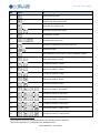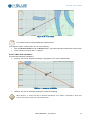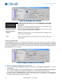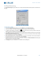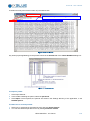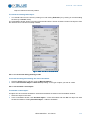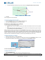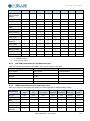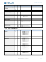
1
Gecdis v8 User’s Manual Gecdis v8 – User’s Manual Revision History Identification Ed. Date Products release Note ISD M 038 A EN A 12/07/2013 Gecdis v8 ECDIS software user manual ISD M 038 B EN B 12/11/2013 Gecdis v8 Appendix D rewrite. Copyright All rights reserved. No part of this manual may be reproduced or transmitted, in any form or by any means, whether electronic, printed manual or otherwise, including but not limited to photocopying, recording or information storage and retrieval systems, for any purpose without prior written permission of iXBlue. Disclaimer iXBlue specifically disclaims all warranties, either expressed or implied, included but not limited to implied warranties of merchantability and fitness for a particular purpose with respect to this product and documentation. iXBlue reserves the right to revise or make changes or improvments to this product or documentation at any time without notify any person of such revision or improvments. In no event shall iXBlue be liable for any consequential or incidental damages, including but not limited to loss of business profits or any commercial damages, arising out of the use of this product. Trademarks Microsoft, MS-DOS and Windows are registered trademarks of Microsoft Corporation. Intel and Pentium are registered trademarks and Celeron is a trademark of Intel Corporation. Delph is a registered trademark of ELICS. Warranty iXBlue provides a standard warranty of one (1) year covering this product against any defect in materials or manufacture. The warranty starts from the date of shipment of the product from iXBlue’s manufacturing premises to customer’s location and its duration is indicated in the certificate of warranty delivered with the product. In the event that a defect in materials or manufacture becomes obvious during the stipulated warranty period, iXBlue will undertake, at its sole discretion, either to repair the defective product, bearing the cost of all parts and labor, or to replace it with an identical product. In order to avail itself of this warranty, Customer must notify iXBlue of the defect before expiry of the warranty period and take all steps necessary to enable iXBlue to proceed. Customer shall be responsible for the packaging and the shipment of the defective product to the repair center notified by iXBlue, the cost of such ii ISD M 038 B EN - 12/11/2013 Gecdis v8 – User’s Manual shipment being borne by Customer. iXBlue agrees to bear the cost of return freight, based on CPT (Cost Paid To) Customer’s airport location, import tax-free. This warranty shall not be construed as covering defects, malfunctions or damages caused by improper use or inadequate maintenance of the product. Under no circumstances shall iXBlue be due to provide repair or replacement under this warranty in order a) to repair damage caused by work done by any person not representing iXBlue for the installation, repair or maintenance of the product ; b) to repair damage caused by improper use or connection to incompatible equipment, and specifically, the opening of the housing of the equipment under warranty shall cause the warranty to be automatically cancelled ; c) to maintain any product that has been modified or integrated into a larger configuration, if such modification or integration increases the duration or difficulty of the maintenance of said product. This warranty covers the product hereunder and is provided by iXBlue in place of all and any other warranty whether expressed or implied. iXBlue does not guarantee the suitability of the product under warranty for sale or any specific use. iXBlue’s liability is limited to the repair or replacement of defective products, this being the sole remedy open to Customer in the event the warranty becomes applicable. iXBlue cannot be held liable for indirect, special, subsequent or consequential damage, irrespective of whether iXBlue has or has not received prior notification of the risk of occurrence of such damage. Export Regulation This product is classified as a dual-use good: it has been developed for non-military use, but could be used for military applications. As a consequence, this product is subject to dual-use goods export control procedures: iXBlue can deliver this product freely to France or any other country of the European Union; iXBlue can export this product under its own Community General Export Authorization EU 001 to the following countries: Australia, Canada, USA, Japan, New-Zealand, Norway and Switzerland; iXBlue can also export this product to other countries but only through the issuance of an individual export license by the French authorities. Once in its country of first destination: From a country member of European Union, this product is free of movement (travel) as long as it remains within the European Union; From a country member of European Union, this product can only be re-exported to a non European Union member country under the dual-use goods export control procedures set forth by the national authorities; From another country, this product can only be re-exported under both the conditions of the original export license from France (depending on its type and content) and the dual-use goods export control procedures set forth by the national authorities. If an individual export license has to be issued by the French authorities, iXBlue requires you to provide as needed a description of your usual activity (and the one of the end-user if different) and the end-user to fill out an end-user certificate which includes: The description of the intended application of the product A commitment not to re-export the product (without applying for an export license to the competent national authorities as set above). This product cannot be exported or re-exported to Cuba, Syria, North Korea, Libya, Sudan and Iran. ISD M 038 B EN - 12/11/2013 iii Gecdis v8 – User’s Manual Text Usage Bold Bold text is used for items you must select or click in the software. It is also used for the field names used into the dialog box. Courier Text in this font denotes text or characters that you should enter from the keyboard, the proper names of disk Drives, paths, directories, programs, functions, filenames and extensions. Italic Italic text is the result of an action in the procedures. Bold and italic Text in this font indicates a sequence to realize. Icons The Note icon indicates that the following information is of interest to the operator and should be read. THE CAUTION ICON INDICATES THAT THE FOLLOWING INFORMATION SHOULD BE READ TO FORBID OR PREVENT PRODUCT DAMAGE. THE WARNING ICON INDICATES THAT POSSIBLE PERSONAL INJURY OR DEATH COULD RESULT FROM FAILURE TO FOLLOW THE PROVIDED RECOMMENDATION: iv ISD M 038 B EN - 12/11/2013 Gecdis v8 – User’s Manual Table of Contents I GETTING STARTED ....................................................................................................... 1 I.1 WELCOME ................................................................................................................................ 1 I.1.1 Requested configuration ...................................................................................................... 1 I.1.2 Installation / Uninstallation ................................................................................................... 2 I.1.3 Launching and Closing Gecdis ............................................................................................ 4 I.2 HOW TO USE THE EQUIPMENT ................................................................................................... 6 I.2.1 The Keyboard Shortcuts ...................................................................................................... 6 I.2.2 Entering Texts ...................................................................................................................... 8 I.2.3 The Mouse ........................................................................................................................... 9 I.3 GECDIS OVERVIEW ................................................................................................................. 10 I.3.1 The Screen ........................................................................................................................ 10 I.3.2 The Cursor ......................................................................................................................... 15 I.3.3 Using Views ....................................................................................................................... 16 I.3.4 Accessing Commands ....................................................................................................... 16 I.4 IMPORTANT FEATURES TO KNOW ............................................................................................ 17 I.4.1 The Own Ship .................................................................................................................... 17 I.4.2 ECDIS and ECS Modes ..................................................................................................... 17 I.4.3 Man Over Board................................................................................................................. 18 I.4.4 Printing the Screen ............................................................................................................ 18 I.4.5 The modules ...................................................................................................................... 19 I.5 WHAT TO DO BEFORE DEPARTURE ......................................................................................... 20 I.5.1 Customizing ....................................................................................................................... 20 I.5.2 Checking ............................................................................................................................ 20 I.6 NAVIGATION TASKS ................................................................................................................ 22 I.6.1 Overview ............................................................................................................................ 22 I.6.2 Voyage Planning ................................................................................................................ 22 I.6.3 Positioning ......................................................................................................................... 23 I.6.4 Steering Modes .................................................................................................................. 23 I.6.5 Monitoring .......................................................................................................................... 24 II GENERAL CONFIGURATION ......................................................................................... 25 II.1 DISPLAY ................................................................................................................................. 25 II.1.1 Screen size ........................................................................................................................ 25 II.1.2 Colour modes..................................................................................................................... 25 II.1.3 Motion control .................................................................................................................... 26 II.2 CONFIGURING THE UNITS ........................................................................................................ 28 II.3 THE DATUM ............................................................................................................................ 29 II.4 THE TOOLBAR ........................................................................................................................ 30 II.4.1 Insert a new button ............................................................................................................ 30 II.4.2 Controls .............................................................................................................................. 31 II.5 ALARMS ................................................................................................................................. 32 ISD M 038 B EN - 12/11/2013 v Gecdis v8 – User’s Manual II.6 THE USERS ............................................................................................................................33 II.6.1 Adding a User ....................................................................................................................33 II.6.2 Configuring Users’ Rights ..................................................................................................33 II.6.3 Opening a New Session ....................................................................................................34 II.7 DANGER DETECTION ...............................................................................................................35 II.8 MISCELLANEOUS ....................................................................................................................37 II.8.1 Back-up data ......................................................................................................................37 II.8.2 Synchronizing Data ............................................................................................................37 II.9 USER INTERFACE ....................................................................................................................39 II.9.1 Tooltips in chart views ........................................................................................................39 II.9.2 General parameters ...........................................................................................................40 II.10 THE INFORMATION WINDOWS ..................................................................................................44 III GECDIS DISPLAY ........................................................................................................ 46 III.1 THE SCALES ...........................................................................................................................46 III.2 COLOUR MODE .......................................................................................................................47 III.3 CENTRING ON A PLACE ...........................................................................................................49 III.4 CENTRING ON A MOBILE ..........................................................................................................51 III.4.1 On Own Ship: .....................................................................................................................51 III.4.2 On any mobile ....................................................................................................................51 III.4.3 Motion control ....................................................................................................................52 III.5 ALARMS .................................................................................................................................55 III.5.1 The Alarm Window.............................................................................................................55 III.5.2 The Black Box ....................................................................................................................55 III.6 THE VIEW MENU......................................................................................................................59 III.7 THE DISPLAY CONTEXT............................................................................................................61 IV MOBILES AND FLEETS ................................................................................................ 63 IV.1 IV.1.1 IV.1.2 IV.2 Mobiles’ Vectors .................................................................................................................63 Apparent Wind and True Wind ..........................................................................................64 THE OWN SHIP .......................................................................................................................65 IV.2.1 Sizes ..................................................................................................................................65 IV.2.2 Heights ...............................................................................................................................66 IV.2.3 Navigation parameters .......................................................................................................66 IV.3 THE MOBILE LIST ...................................................................................................................67 IV.4 ALARMS .................................................................................................................................69 IV.4.1 Own Ship Specific Alarms..................................................................................................69 IV.4.2 Target/AIS alarms ..............................................................................................................71 IV.5 REPRESENTATION...................................................................................................................74 IV.5.1 Defining a Mobile Appearance ...........................................................................................74 IV.5.2 Standard representation ....................................................................................................76 IV.5.3 Defining a Specific Appearance for a Mobile or a Fleet ....................................................79 IV.6 vi NAVIGATION ...........................................................................................................................63 CONFIGURATION .....................................................................................................................82 ISD M 038 B EN - 12/11/2013 Gecdis v8 – User’s Manual IV.6.1 Information ......................................................................................................................... 82 IV.6.2 Streams .............................................................................................................................. 86 IV.6.3 Creating Mobiles and Fleets .............................................................................................. 93 IV.6.4 Assigning Information to a Mobile...................................................................................... 94 IV.6.5 Configuring Information ..................................................................................................... 94 IV.6.6 Inheriting Information ......................................................................................................... 97 IV.6.7 Sensor Synthesis ............................................................................................................... 98 IV.7 DEAD RECKONING ................................................................................................................ 101 IV.8 FIX POSITION ........................................................................................................................ 102 IV.8.1 Fixing position .................................................................................................................. 102 IV.8.2 Display of fix positions ..................................................................................................... 102 IV.8.3 Fix position settings ......................................................................................................... 102 V CHARTS .................................................................................................................. 103 V.1 CHART CATALOGUE ............................................................................................................. 103 V.1.1 Displaying the chart coverage ......................................................................................... 103 V.1.2 List of Charts .................................................................................................................... 104 V.1.3 Filtering Charts ................................................................................................................. 104 V.1.4 Displaying the planisphere in background ....................................................................... 105 V.2 ENC CHARTS (IXBLUE FORMAT)........................................................................................... 106 V.2.1 Introduction ...................................................................................................................... 106 V.2.2 Chart database presentation ........................................................................................... 107 V.2.3 Managing the chart database .......................................................................................... 109 V.2.4 Getting an import report ................................................................................................... 111 V.2.5 Getting information on the cells ....................................................................................... 112 V.2.6 Reseting the database ..................................................................................................... 112 V.2.7 Centring the chart area on a cell ...................................................................................... 112 V.2.8 Importing/deleting user permits ....................................................................................... 112 V.2.9 Loading certificates .......................................................................................................... 114 V.2.10 Chart Loading Modes ...................................................................................................... 114 V.2.11 Updating ........................................................................................................................... 115 V.2.12 Chart Presentation ........................................................................................................... 122 V.2.13 Danger detection or anti-grounding ................................................................................. 127 V.2.14 Consulting Information on an Object ............................................................................... 129 V.3 ARCS CHARTS .................................................................................................................... 131 V.3.1 ARCS Overview ............................................................................................................... 131 V.3.2 Charts .............................................................................................................................. 134 V.3.3 Consulting Information about Charts ............................................................................... 137 VI NAVIGATION ............................................................................................................ 140 VI.1 BEARING LINES AND BEARING RANGE LINES......................................................................... 140 VI.2 CLEARING LINES .................................................................................................................. 142 VI.3 GEOGRAPHIC CALCULATIONS ............................................................................................... 144 ISD M 038 B EN - 12/11/2013 vii Gecdis v8 – User’s Manual VI.4 PILOTING FIX ........................................................................................................................146 VI.4.1 Overview ..........................................................................................................................146 VI.4.2 Using piloting fix ...............................................................................................................146 VI.5 SAR DIAGRAMS ...................................................................................................................148 VI.5.1 Overview ..........................................................................................................................148 VI.5.2 Square Spiral Route .........................................................................................................148 VI.5.3 Sector Route ....................................................................................................................149 VI.5.4 Parallel Route ..................................................................................................................150 VII USER OBJECTS ........................................................................................................ 153 VII.1 DATABASES AND FOLDERS ...................................................................................................153 VII.2 M ANAGING USER OBJECTS ....................................................................................................154 VII.2.1 General Operation on User Objects ................................................................................154 VII.2.2 List of user objects ...........................................................................................................154 VII.2.3 Configuring the filters .......................................................................................................155 VII.2.4 Importing user objects......................................................................................................155 VII.2.5 Exporting a user object ....................................................................................................157 VII.3 ROUTES ...............................................................................................................................158 VII.3.1 Creating a route ...............................................................................................................158 VII.3.2 Route properties ..............................................................................................................159 VII.3.3 Planning a route ...............................................................................................................161 VII.3.4 Duplicating a route ...........................................................................................................162 VII.3.5 Representation of a route ................................................................................................162 VII.3.6 Switching in route monitoring ...........................................................................................163 VII.3.7 The pilot view ...................................................................................................................164 VII.3.8 Autopilot control ...............................................................................................................164 VII.3.9 The channel view .............................................................................................................166 VII.3.10 Channelling ......................................................................................................................166 VII.3.11 Importing/Exporting routes ...............................................................................................167 VII.4 TRACKS ...............................................................................................................................168 VII.4.1 Starting/stopping a track ..................................................................................................168 VII.4.2 Track templates ...............................................................................................................168 VII.4.3 Track color filters ..............................................................................................................168 VII.4.4 Displaying the track profile ...............................................................................................169 VII.4.5 Changing the track properties ..........................................................................................170 VII.5 M ARKS AND EVENTS.............................................................................................................171 VII.5.1 Creating Marks .................................................................................................................171 VII.5.2 Configuring Mark Display Options ...................................................................................173 VII.6 AREAS .................................................................................................................................175 VII.7 CIRCLES AND SECTORS .........................................................................................................177 VII.8 TEXT ....................................................................................................................................178 APPENDIX A GLOSSARY ............................................................................................... 179 viii ISD M 038 B EN - 12/11/2013 Gecdis v8 – User’s Manual APPENDIX B ECDIS INFORMATION MANDATORY ............................................................ 187 APPENDIX C THE PRESENTATION LIBRARY, CHART 1 ..................................................... 188 APPENDIX D EQUIPMENT CAN BE INTERFACED WITH GECDIS .......................................... 194 APPENDIX E SHIP OUTLINE ........................................................................................... 204 INDEX ............................................................................................................................. 206 ISD M 038 B EN - 12/11/2013 ix Gecdis v8 – User’s Manual I GETTING STARTED For simplicity in this manual, the term Gecdis is used as a generic name to identify the name of the software, which has several product name: SeaXpert, Gecdis-C, SeaPix... I.1 Welcome Gecdis is a navigational aid system with a geographic information system, working on standard computers fitted with Windows XP, Windows Vista or Windows Seven. Navigational aid is given by displaying electronic charts, on which information from the ship equipment and sensors connected to Gecdis are shown, such as: GPS, gyrocompass or depth-sounder navigation tools. Gecdis fits IMO regulations for cartographical data storage (SP52) and their displaying (SP57). Gecdis is fitted with in-line and independent tools, allowing system customisation according to three levels: the ship's equipment, the user and his practices, hierarchy and access rights. Furthermore, Gecdis provides independent back-up arrangements to ensure safe navigation in case of a failure. So if your machine suddenly malfunctions, the parameters the equipment does not need to be reinitialised manually, and operator settings, do not change. I.1.1 REQUESTED CONFIGURATION I.1.1.1 Computer Composant Minimum request / advisable Operating system Windows XP, Windows Vista or Windows Seven Processor Intel Pentium 4 or more RAM 1GB Hard disk 1GB (10GB advisable) CD/DVD drive One unit for installation Pointing device Mouse or Trackball Input device Keyboard Video card 3D graphic card USB port One for HASP key COM and NET ports As many communication ports as connected devices I.1.1.2 Screen Gecdis has been designed to be used with one or several screens, a minimum of two is recommended. Here are the necessary criteria of the screen to be consistent with the ECDIS standard: The operational display area of the chart presentation for route monitoring shall be at least 270 mm × 270 mm. For ECDIS back-up arrangements, the effective size of the chart presentation shall be not less than 250 mm × 250 mm or 250 mm diameter. Operational display equipment including multifunction displays (for example, conning displays) shall provide a minimum screen resolution of 1280 × 1024 pixels, or equivalent for a different aspect ratio, except where permitted or not required by the IMO, or when used for a single specific purpose (for example, speed log, echo-sounder). Display equipment intended to support the presentation of electronic chart information shall provide a maximum pixel pitch of 0,29 mm/m of nominal viewing distance (1 min of arc), for example, 0,36 mm at 1 237 mm viewing distance. ISD M 038 B EN - 12/11/2013 1 Gecdis v8 – User’s Manual I.1.2 INSTALLATION / UNINSTALLATION Figure I.1 : CD-ROM AutoPlay Menu To install Gecdis into your hard disk: 1 2 3 4 5 6 Connect the HASP key on the USB port of your machine. If Windows asks you to install a new device, cancel the procedure, the pilot of the dongle will be installed with the installation of Gecdis. Insert iXBlue’s CD -ROM into the appropriate drive. Select the first line of the autoplay menu (with product name reference), or if the installation does not start automatically, double-click on the exe file in the setup folder. Select the language for installation. An install wizard guides you through the steps of Gecdis installation. Figure I.2 : Setup Wizard 2 ISD M 038 B EN - 12/11/2013 Gecdis v8 – User’s Manual Figure I.3 : Preconfiguration choice YOU CAN, IF YOU WANT, USE « TURBO W IN » MENUS AND SHORTCUTS. TO DO SO, CHECK THE OPTION TURBOWIN MODE IN THE W IZARD PRECONFIGURATION CHOICE PAGE. HOWEVER WE DO NOT RECOMMEND USING THIS MODE. INDEED IT HAS LIMITS RELATED TO GECDIS INTERACTION MODALITIES. FOR THOSE WHO ARE USING TURBOW IN, IT IS ONLY INTENDED TO HELP THEM USE GECDIS ERGONOMY. SEE II.9.2.2, PAGE 41 FOR AN OVERVIEW OF THIS MODE. 7 The CD-ROM content is then copied into your hard disk, and you can eject at the end of the procedure. To uninstall Gecdis from your hard disk: 1 2 3 4 Open Windows Control Panel. Select Add/Remove Programs. Select Gecdis in the list of programs and click Uninstall. An uninstallation wizard will guide you through the required steps. ISD M 038 B EN - 12/11/2013 3 Gecdis v8 – User’s Manual I.1.3 LAUNCHING AND CLOSING GECDIS 1 2 Figure I.4 : Launching Gecdis Gecdis launching and closing are quite typical of Windows applications, but you must be sure to have connected the dongle software on the computer. To launch Gecdis: 1 2 3 On the desktop system, there is definitely a shortcut to launch Gecdis. Or otherwise, in the Windows taskbar, click Start, Programs, iXBlue, then click the line corresponding to the product name (as SeaXpert, Gecds-C,...) to open the last menu and click again on the line product name. The welcome dialog box opens. In the list of the User field, select the user you want to log on and enter the password for this user in the Password field. Figure I.5 : Launching Gecdis 4 4 Click OK. ISD M 038 B EN - 12/11/2013 Gecdis v8 – User’s Manual At first start or if you have set a password or more users, you will identifer just after the splash screen to continue launching the software. Otherwise, the identification step is ignored. To close Gecdis: 1 2 Click System and then Exit. A confirmation window is displayed. Click Yes. Before closing, the software saves all the parameters necessary to restart in the same state. ISD M 038 B EN - 12/11/2013 5 Gecdis v8 – User’s Manual I.2 How to Use the Equipment I.2.1 THE KEYBOARD SHORTCUTS Shortcut keys offer you another way to accomplish common tasks. In many cases, shortcut keys help you to work faster. Using a shortcut key usually consists in pressing and holding one key while pressing a second key. THE CONCEPT OF ACTIVE WINDOW IS IMPORTANT FOR MANAGING KEYBOARD SHORTCUTS, PARTICULARLY WITH DEAD RECKONING CONTROLS ON A MOBILE ARE INTERCEPTED ONLY BY THE MAIN VIEW . SEE II.9.2.1, PAGE 40 TO CONFIGURE THE ACTIVE WINDOW. Gecdis standard shortcuts: The following is a list of the shortcut keys currently available in Gecdis. In the following keyboard picture, shortcuts numbers have been assigned to keys. Each number corresponds to a shortcut key combination. 1 2/3 4/5 6/7 8 10 9 11/12 13/14 15 23/29 38 22/28 30 31 32/35 33/36 14 24-29 34-37 3/5/7 12 17-29 37 16 25-27 39 16 Figure I.6 : Keyboard and Shortcuts Nb Press To 1 Access online help. 2 Centre on Own Ship. 3 + 4 5 Zoom up. + 6 7 8 6 Skip to relative motion mode. Select the best scale. Zoom down. + Close view that has focus (with the exception of the main view). Skip to North-up mode. ISD M 038 B EN - 12/11/2013 Gecdis v8 – User’s Manual Nb Press To 9 Skip to Head-up mode. 10 Create a Man Over Board event. 11 Select the next coulor mode. 12 Select the previous coulor mode. + 13 Acknowledge an alarm. 14 Show/Hide the alarm menu. + 15 Maximize or restore the size of the main view. 16 Validate (left click). 17 Switch between mouse centre or chart consultation modes. 18 19 20 21 22 23 24 25 26 27 28 29 1 2 1 2 Reduce the mobile’s SOW . + 1 2 Increase the mobile’s SOW . + 1 2 Reduce the mobile’s COW . + 1 2 Increase the mobile’s COW . + 1 2 Reduce the mobile’s depth . + 1 2 Increase the mobile’s depth . + 1 + + + + + + + + + + + + 2 Reduce the mobile’s drift speed . 1 2 Increase the mobile’s drift speed . 1 2 Reduce the mobile’s drift course . 1 2 Increase the mobile’s drift course . 1 2 Reduce the mobile’s height of tide . 1 2 Increase the mobile’s height of tide . This mobile is one that is currently selected or the ownship if none is selected. Only if this information is configured on an estimated source. ISD M 038 B EN - 12/11/2013 7 Gecdis v8 – User’s Manual Nb Press To 30 Divide the zoom by 10. 31 Rise the zoom by 10. 32 Zoom down. 33 Zoom up. 34 Window zoom. 35 Reduce the window zoom. + 36 Enlarge the window zoom. + 37 Inverse the zoom window. + 38 Print the main view. 39 or I.2.2 or or Move the mobile position of the relative motion. ENTERING TEXTS Text can be entered to define several elements: A position Numerical characters (heading, speed, distance, date) Free text In some cases, text is entered “in a controlled way”. So when a specific kind of character is to be entered, it is not possible to enter another one. For example, if the character should be a number, it is not possible to enter an alphabetical character. Likewise, while editing a heading, you won’t be able to enter a value which is superior to 359,9°. I.2.2.1 Geographic editor As this editor allows you to enter a position in any format, the validity of characters entered is not monitored in real time, but at the end of the entry. The geographical editor is special because it has a button (with a cross) to use the mouse in a geographic view to set the new position. Figure I.7 : Geographic editor 8 ISD M 038 B EN - 12/11/2013 Gecdis v8 – User’s Manual It also has a contextual menu to initialize the text in another format: Figure I.8 : Geographic editor contextual menu I.2.3 THE MOUSE Figure I.9 : Using the Trackball The mouse is a pointing device allowing to operate almost any action on the software. It consists of a ball that allows to move the cursor on screen and two or three buttons, each of them having a specific use. ISD M 038 B EN - 12/11/2013 9 Gecdis v8 – User’s Manual I.3 Gecdis Overview I.3.1 THE SCREEN Title bar Menu bar Info. bar Main view title Info. pages Critical info. Toolbar Secondary title Main view Secondary window Status bar Alarm bar Figure I.10 : The Workspace Gecdis consists of several windows and bars: I.3.1.1 The main view The menu bar Title bars Toolbars Information windows Secondary windows (Chart Overview, Pilot, consultation, etc.) And other specific windows (Alarms, dialogs,...) The main view This is the area's largest map display application. Allows displaying several layers of information the user can select (e.g.: chart, user objects, mobiles, radar data). The main view enables to display several types of information layers that the user can select: I.3.1.2 Chart, User objects, Mobiles (ownship, target,...), datas provided by the sensors available onboard (radar, trawl system sensors, ..), Additional data provided by commercial databases (current, bathymetry, sediments, oceano,...). The menu bar Gecdis is a Windows based software containing different menus. Figure I.11 : The menu bar 10 ISD M 038 B EN - 12/11/2013 Gecdis v8 – User’s Manual Here is the list of the basic menus and their use. This list can increase depending on your options (Radar, Oceanography, etc.). Figure I.12: An example menu - the Display menu The Windows type menu bar lists all software menus. A menu is a list of commands that have in common the action they allow to do. It consists of: Submenus allowing to access another menu (example: Orientation). Those kinds of submenus are followed with an arrow; Commands allowing to open dialog boxes (example: Centre on Place…). Those commands are followed with suspension points; Commands running directly an action (example: Ecdis Mode). Selecting a command highlights it in blue. When it is not possible to use a command, this one is greyed (example: Best Scale). The menu bar includes the following menus: System, mainly manages the configuration, print, user change and exit application. Display, allow you to use some ECDIS main functions (zoom, colour modes, etc). Mobile, manages the main controls for fleet of mobile. Navigation, manages navigation elements and autopilot. User Object, creates and manages the user objects. View, enables the display of the different windows on the screen and allows to configure display contexts. ?, displays information about the software. Some other menus may be added depending on the current Gecdis version. These menus are as follows: Radar allows you to use Gecdis as a radar Bathy allows you to configure and display the bathymetry. You can display a coloured layer representing charted depth and also isolines AMLs presents the commands required to use additional data layers that have been designed to satisfy maritime defence requirements Weather allows you to display wind and pressure parameters at a particular day and time. Tide allows you to display and configure the display of tides. ... THE DISPLAY OF THE MENU BAR DEPENDS ON USER RIGHTS LOGGED ON, FOR EXAMPLE BY DEFAULT NAVIGATORS AND GUESTS USERS DO NOT HAVE ACCESS. I.3.1.3 Title bars Each window or dialog box contains a title bar. Some of them display a title; others display several pieces of information that cannot be modified, which is the case for the title bar of the main view. ISD M 038 B EN - 12/11/2013 11 Gecdis v8 – User’s Manual Figure I.13: Main view bar title The pieces of information are as follows: The motion control type (TM or RM), The chart type (ENC, ARCS…), The projection, The scale, The datum, And possibly other information provided by the cartographic module. I.3.1.4 Status bar This is an area at the bottom of the software window dedicated to the display of system informations and waiting messages. Figure I.14: The status bar It is mainly composed with information in order: Local time (with timezone letter), Cursor position or screen center, Bearing Ownship-Cursor, Distance Ownship-Cursor, TTG Ownship-Cursor, I.3.1.5 Toolbars The toolbar serves as an easy-to-use interface for performing common functions. It enables you to speed up the implementation of specific actions by a single click on a button. Figure I.15: Upper toolbar There are 2 main toolbars: The upper toolbar (horizontal) with functions for navigation and security navigation, And the lateral toolbar (vertical) displaying the main functions for fishing operation and the access to optional expert modules. As for specific requirements, the skipper (or the operator when installing the application) can create/modify the commands for each toolbar. W HEN THE MENU BAR IS NOT DISPLAYED (E.G.: IF A GUESTS-TYPED USER IS LOGGED ON), YOU CANNOT CLOSE THE TOOLBAR. I.3.1.6 Information windows I.3.1.6.1 Critical information The banner with critical information enables to display data types that have been previously selected. They are related to the ownship or to the cursor and are provided by the sensors or computed. To display the critical information window, you must select the corresponding command in the View menu. When a piece of information is not available (incorrect or nonexistent), the corresponding field is filled with red ‘?’ character. Information is displayed with different colours depending on their accurateness: 12 High and normal quality information is displayed in green. Invalid information is displayed in red. ISD M 038 B EN - 12/11/2013 Gecdis v8 – User’s Manual Undefined information is displayed in gray. Figure I.16: Critiacl information window This information bar can be displayed either on the chart, or in the information bar in the right hand side of the screen. When displayed on the chart, you can move it to any position on the chart area with the mouse. IN ECDIS MODE, THIS WINDOW IS AUTOMATICALLY FORCED INTO THE RIGHT HAND SIDE OF THE SCREEN. I.3.1.6.2 The Information Bar Allows to display previously selected pieces of information that are computed or come from sensors. To display the information bar, you must select the corresponding command in the View menu. You can superpose several bars, creating bars by themes (for example, one bar may stand for Own Ship’s information and another one for information about a route that is monitored). When a piece of information is not available (incorrect or nonexistent), the corresponding field is not filled in. Pieces of information are displayed with different colours depending on their accurateness: High-quality pieces of information are displayed in blue (e.g.: a position acquired in differential mode) Normal quality pieces of information are displayed in black/white. Invalid pieces of information are displayed in red (e.g.: a piece of information whose acquisition maximum timeout is over). Figure I.17: Default information bar 1 (Ownship) Figure I.18: Default information bar 2 (System) To skip from a bar to another, click on it. To configure a bar, right click on it and then click Customize… (see II.10 page 44). I.3.1.6.3 Information pages Information pages allow to display previously selected pieces of information in another form than information bars. To display information pages, you must select the corresponding command in the View menu. Three tabs are selected by default, each of them displaying pieces of information by theme: about the Own Ship, the system and route monitoring. You can add or delete tabs and/or pieces of information to create themes. For this, right clicking on the window and clicking Customize… (see II.10 page 44) ISD M 038 B EN - 12/11/2013 13 Gecdis v8 – User’s Manual Figure I.19: Information pages I.3.1.7 Secondary windows Secondary windows (General view, Channel view, Pilot View, etc.) correspond to a specific use of Gecdis. Their common characteristics are as follows: They can be displayed from the View menu, except the consultation window, which is displayed after selecting an object in the main view. By default they are docked (most of the time), i.e. they are “fixed” in a location of the screen that has been previously defined. They can be moved outside the area; then they are in floating mode and it is possible to resize them. You can also locate several views side by side or one above the other. In the latter case, the first view is displayed above the second one. They can be part of a display context. A display context is a configuration of the screen layout that contains, amongst other things, windows that have been previously selected by the user. You can save this configuration, to use and display it later (see III.7, page 61). I.3.1.7.1 Consultation windows When selecting an object in geographic view, a window is displayed on the right of the screen (by default). Above, the selected object is described. In the lower part of the window are buttons to perform different actions can be based on the selected object. Figure I.20: Consultation window Those buttons are not identical; they depend on the selected object. For example a route will be the only object with an available button called Planned Route, this button allows to select the route as the one to be monitored. I.3.1.7.2 List windows The list windows (e.g.: list of user objects) allow you to manage lists that are sorted out in a hierarchical way. Generally they consist of: A menu bar (above), A tree that gathers all the folders of the lists (on the left), The contents of the element which is selected in the tree. The contents of these kinds of windows are more likely to fit across widthways. That’s why they default below in the screen. 14 ISD M 038 B EN - 12/11/2013 Gecdis v8 – User’s Manual I.3.1.8 Pop-up menus A pop-up menu is a menu that appears on the screen when you right click, and whose options correspond to the current clicked object. When you right click the main view on empty area, a pop-up menu displays; this menu includes some commands such as the ability to change user. Other pop-up menus can be displayed, depending on the part of the screen in which you have clicked (e.g.: in the Channel window) or circumstances (right click on a selected user object). I.3.1.9 Dialog boxes A dialog box is a specific area of the screen that is displayed after a user’s action – when the user gives an order to the software that requires further information or to make choices between several options before running. There are two kinds of dialog boxes: I.3.2 Modal dialog boxes (e.g.: System, Setting, General configuration…): this kind of dialog box requires that the user gives the adequate information before he can continue to work. Modeless dialog boxes (e.g.: Mobile, Own Ship Dead Reckoning…): this kind of dialog box is left open as long as the user doesn’t close it; it can then be used several times for different purposes, because the user can work while this dialog box is open. THE CURSOR In main view, the cursor appears in different forms and reflects a current action: ECS mode ECDIS mode Action Default mode, center with left click and consultation with right click. Chart consultation mode by pressing the Ctrl key. Object move in progress. Geographic scrolling in any direction by pressing the left mouse button. Geographic scrolling to the east (when the cursor is near the edge of the view). Geographic scrolling to the north (when the cursor is near the edge of the view). Geographic scrolling to the north-east (when the cursor is near the edge of the view). Geographic scrolling to the north-west (when the cursor is near the edge of the view). Geographic scrolling to the south (when the cursor is near the edge of the view). Geographic scrolling to the south-east (when the cursor is near the edge of the view). Geographic scrolling to the south-west (when the cursor is near the edge of the view). ISD M 038 B EN - 12/11/2013 15 Gecdis v8 – User’s Manual ECS mode ECDIS mode Action Geographic scrolling to the west (when the cursor is near the edge of the view). Window zoom in by pressing Shift key. Zoom out by pressing Ctrl+Shift keys. I.3.3 USING VIEWS Gecdis screen includes three default locations for views and windows: above, on the right and below. When you display a view or a window for the first time, it is located by default on one of these three locations. You can then move and resize it in order to match with your needs (displaying specific views on specific locations). You can locate two views side by side or one above the other. In the latter case, the first view is displayed above the second one. This window management is handled by the display contexts in View menu (see III.7, page 61) and all positions of the windows are saved. To move a view: 1 2 Click the blue title bar of the view you want to move and drag it holding down the left button of the mouse. If you drag the view outside the location in which it should be docked; the view is displayed without icons, in floating mode. If you move the location of a view and then you close it, the next time you will display it again it will be located on the new location. I.3.4 ACCESSING COMMANDS Gecdis is a Windows-based software, and like any Windows-based software, it allows you to access commands in different ways: 16 In the menu bar. With Shortcuts. With the toolbars. With contextual menus. With context-sensitive buttons that appear on the right of the screen when you select an object. In the dialog boxes and windows. ISD M 038 B EN - 12/11/2013 Gecdis v8 – User’s Manual I.4 Important Features to Know I.4.1 THE OWN SHIP Own ship in Gecdis associated with one or more mobile. The Own Ship (with initial uppercase) is the main vessel and is the basis for many treatments (informations relative to, alarms, route monitoring, man over board, ...). Several secondary vessels can be added, their goal is to represent other sources of information to compare to that of the main vessel (Own Ship). For example, the Own Ship can be acquired from a GPS and a secondary vessel can be estimated. In this example, if at a given time, the GPS fails, the user is ability to reverse the ship and have therefore estimated Own Ship. To differentiate vessels in views, the Own Ship is drawn in black/white, the secondary vessels in gray. When launching Gecdis for the first time, the Own Ship is created with a set of informations (position, SOG, COG, SOW, true heading, depth) configured on an automatic source. Generally to receive data, it must be checked, add and configure the stream where the sensors are connected. Figure I.21: Default Own Ship configuration I.4.2 ECDIS AND ECS MODES By a single mouse click, Gecdis allows you to skip from ECS (Electronic Chart System), which is a non ECDIS mode, to ECDIS mode. For this, you can use the command in the View menu, or use the default button sets in the horizontal toolbar. Looking at the menu item corresponding to the command or button in the toolbar, you can determine the software mode: if a check is present, the ECDIS mode is active, otherwisethe software is in ECS mode. Switching to ECDIS mode brings several changes in the display of geographical views and several functionalities: If the current chart provider is not compliant ECDIS, no map data will be displayed. The cursor has the same shapes as those defined by the ECDIS (see I.3.2 page 15). The user objects follow ECDIS appearance: they are orange. The symbol of event objects is drawn with special icon (MOB for example). Some settings that relate to ships’ appearances cannot be performed (see IV.5 page 98). So ship’s appearance and the representation of its vectors, labels, etc... may be different. The critical information window is docked if it were floating on the main view (chart display mode only). The inconsistent position alarm is forced to activate if it was inactive. ISD M 038 B EN - 12/11/2013 17 Gecdis v8 – User’s Manual Figure I.22: ECS mode Figure I.23: ECDIS mode In this case, mobile appearence is non ECDIS, user objects have their own colors. In this case, mobile appearence is ECDIS forced, and user objects are always drawn in orange. I.4.3 MAN OVER BOARD Man Over Board is a very important command in Gecdis. This command is available in different ways: In the menu Navigation by selecting the first line Man Over Board ! In the horizontal toolbar by default, there is a assigned button. With the shortcut F8 key. This command is not confirmed, a man overboard is created just after validation. A visible symbol corresponding to the event is created at the Own Ship position and bearingrange line is added. I.4.4 PRINTING THE SCREEN Anytime, the software allows you to print the main view, as shown in the screen provided with mobiles and user objects. Everything outside the main view (views, bars, and even dialog boxes) does not appear in the printout. Anytime, the software allows you to print the contents of the screen, as shown. This function is included in the System menu. For greater convenience, you could press the Print Screen key of your keyboard. This key allows you to access directly the Windows print dialog box. The default orientation of the print is always fixed in landscape mode. 18 ISD M 038 B EN - 12/11/2013 Gecdis v8 – User’s Manual Figure I.24: Printing example I.4.5 THE MODULES It should be understood that Gecdis is a modular software, ie that its features will be dependent on the number of installed and loaded modules according to the license provided with the software. As its features are not fixed in advance, its interface is evolving accordingly. It is for this reason that the sample screens in this manual may not always be in accordance with your system. Two types are distinguished module: The cartographic modules that are providers of chart datas. They are responsible for their own menus to manage their various parameters and display their data. There can only be one active cartographic module. In this category are such basic module Planisphere which manages the display of a world map, and ENCs evolved module that manages the ECDIS charts. The available sub-menu System, Settings, Charts, Chart Provider allows controller cartographic modules installed and possibly change the module to use. The modules performing various tasks ranging from database management to the management of I/O, mobile, navigation tools, special views, etc ... Unlike the cartographic modules, Gecdis can load as much as the license allows. Some are dependent on the other, such as Route module does not load if the User module does not. The vast majority of Gecdis menus are built entirely by these modules. The About window Gecdis allows you to check the number of modules used by clicking in the window and using the mouse wheel. ISD M 038 B EN - 12/11/2013 19 Gecdis v8 – User’s Manual I.5 What to Do Before Departure The following describes some operations you should do before your departure and where you could find information about them in this manual. I.5.1 I.5.1.1 CUSTOMIZING Configuring your screen size Configuring your screen size is a very important step. If it is not correctly configured, objects of the main view may be disproportionate. See II.1.1, page 25 to configure your screen size. I.5.1.2 Customizing Gecdis screen You can customize some parts of the Gecdis screen. For example, you can optimize the placement of the various windows that you need, define what own ship informations and in what order you want to view or select the commands you use most often. See II.4, page 30 to configure the toolbar. See II.9, page 39 to configure windows informations. See III.7, page 61 for more information about Gecdis customisation. I.5.2 I.5.2.1 CHECKING Datum You must check that your system is configured with the correct datum to avoid errors while positioning. See II.3, page 29 to select the current datum. I.5.2.2 Sensors Check the configuration of your sensors. Each sensor must be connected to a communication port of your machine. You add these communication ports to Gecdis and configure them to acquire specific sentences. See IV.6.2, page 86 to configure a stream. See IV.6.5, page 94 to configure an information. I.5.2.3 Implementing alarms Many alarms are managed in Gecdis. Here are some links to set some alarms. See II.5, page 32 to configure alarms display. See III.5, page 55 to consult alarms. See II.9, page 39 to configure the danger detection. See IV.3, page 67 to manage specific alarms to Own Ship. See VII.5, page 171 to assign to an area an alarm when a ship entres or leaves. I.5.2.4 Route management Routes are a very important step to navigation. You will certainly need to create routes before any departure with a new itinerary. See VII.3.1, page 158 to create a route. See VII.3.6, page 163 to skip to route monitoring. See VII.1, page 153 to learn more about user database. I.5.2.5 Charts Check that you have imported all the charts you need for your voyage in the chart databases. See V.2.3, page 109 to manage the ENC chart database. See V.2.12.4, page 125 to set values for different water contours and depths that will ensure safe navigation. 20 ISD M 038 B EN - 12/11/2013 Gecdis v8 – User’s Manual See V.3.2.1, page 134 to manage the ARCS chart database. ISD M 038 B EN - 12/11/2013 21 Gecdis v8 – User’s Manual I.6 Navigation Tasks I.6.1 OVERVIEW Navigation consists in four basic tasks: I.6.2 Voyage planning, Positioning, Sterring, Monitoring. VOYAGE PLANNING When you plan a voyage, you prepare it; i.e. you define, calculate and optimise the route. You also have to prepare your charts (insertion, updating): I.6.2.1 Route planning, Chart calculation, Chart planning. Route Planning Route planning allows you to modify an existing route or create a new one. A route is defined by the following elements: Position of each waypoint, Turn radius for each waypoint, Safe water calculation based on Safety limits, Lane for each leg (cross track error). Information is available: Alarm window to alert operator, The consultation window to have information on the route, when selected, Pilot window. Customisation: I.6.2.2 Information windows allow to display your desired pieces of information, The toolbar allows to insert the buttons that correspond to your needs. Route Calculation Route calculation for voyage planning includes the following. Calculation of the profile of the route: Distance between consecutive waypoints, Course between waypoints, Wheel-over calculation, Total distance, Estimated time for voyage. Check of the route: Check of the dangers of the route. Voyage optimisation: I.6.2.3 22 Time table optimisation, Optimisation based on economical factors, ECDIS processor calculates optimum speed and course between each waypoint, and the ETA following specified data. Chart Planning Loading of new ENC charts, Updating existing ENC charts, ISD M 038 B EN - 12/11/2013 Gecdis v8 – User’s Manual I.6.3 User generated safe water areas. POSITIONING Positioning is the way to calculate and keep updated the position of the ship during a voyage. The calculation of the position of the ship is based on available navigation sensors: I.6.3.1 Direct positioning of sensors, Dead reckoning, Manual correction. Direct positioning of sensors Satellite navigation systems: I.6.3.2 GPS navigator, GPS navigator with a differential correction facility, DGPS. Dead reckoning equipment Ship’s heading measurements devices: Gyro compass (one or two), Magnetic compass, GPS gyro compass, Inertial unit, Speed measuring devices: I.6.3.3 Single axis speed logs, Dual axis speed logs, Radio navigation equipment, Satellite navigation equipment, Manual Correction User inputs corrections for the position to adjust the position of the antennas relative to conning. I.6.4 STEERING MODES Steering includes all the different operation modes for steering in order to turn the ship through planned voyage (harbour to harbour): I.6.4.1 Hand steering, Trackpilot steering, Waypoint approach mode. Hand Steering Hand steering mode: I.6.4.2 I.6.4.3 Steering wheel. Trackpilot Steering Operator sets the required heading of the vessel, Turn radius is also set by operator, Turn is initiated by operator, The navigation system displays required heading, radius, rate of turn and predicted turn. Waypoint Approach Mode The system will follow the planned track to next waypoint, When reaching the next wheel-over the system alerts operator, The system performs the turn at planned radius. ISD M 038 B EN - 12/11/2013 23 Gecdis v8 – User’s Manual I.6.5 MONITORING Monitoring is a continuous check of navigation data, user actions and performances of the system. Part of the monitoring is also the display of electronic sea chart and conning information: I.6.5.1 I.6.5.2 I.6.5.3 I.6.5.4 I.6.5.5 24 Electronics sea charts, Conning information, Alarms, Man over board, Data logging. Display of electronic sea chart Own ship position, Planned track, Grounding alarm, Chart information. Display of conning information Ship’s heading, Speed (single or dual-axis), Rate of turn order and direction, Depth, Wind speed and direction, Waypoint bearing, Waypoint ETA, Speed order, Steering mode. Alarms Route monitoring, Position calculation, Position monitoring, Waypoint approach, Sensor failure, System failure, Incorrect operator action, Unsafe water areas. Man over board Built-in function for man over board. Data Logging History book, Voyage recording. ISD M 038 B EN - 12/11/2013 Gecdis v8 – User’s Manual II GENERAL CONFIGURATION II.1 Display The Display tab allows you to configure the main display properties: colour modes, motion control and screen size. To access the Display tab: 1 2 In the System menu, click Settings, and General configuration… In the Configuration dialog box, select the Display tab. Figure II.1: Configuring the Display Tab II.1.1 SCREEN SIZE IT IS VERY IMPORTANT THAT YOU CONFIGURE THE EXACT DIMENSIONS OF YOUR SCREEN. IF YOU DO NOT CONFIGURE THEM, THE MAIN VIEW AND ALL OF ITS ELEMENTS MAY BE DISPROPORTIONATE. Two possibilities to adjust the screen size: Automatic: in this case, the screens dimensions are determined automatically based on the placement of windows on the screens. This is the most accurate and safest choice, especially when changing or multi-screens. Displays connected and recognized by the system are listed in the upper area specifying their dimensions. Fixed size: in this case, the dimensions of the screen are entered manually. This is useful if the connected display is not recognized by the system or if its size can not be known automatically (eg with a video projector). Note on ECDIS compliance: when the size of your screen is correctly configured, Gecdis displays the cartographic texts (ENC) with a height of 3.5mm, which corresponds to a nominal viewing distance of one meter. II.1.2 COLOUR MODES In ECDIS Calibrated display topic, you can automatically calibrate screen connected to a serial port. In this case, you must select the type of display connected in the combo box. The Black background in day mode option enables to display the cartographic in day mode with black background. Normaly, the background is white (default configuration). ISD M 038 B EN - 12/11/2013 25 Gecdis v8 – User’s Manual The White background in dusk mode option enables to display the cartographic in dusk mode with white background. Normaly, the background is black (default configuration). Overview of Colour modes: Colour mode Result Day with white background (default) Day with black background Dusk with black background (default) Dusk with white background Night with always black background II.1.3 MOTION CONTROL Motion control manages how the main view to follow a mobile (Own Ship or any mobile). You should know that the motion control has two modes: true and relative motion. See III.4.3.1 page 52 for more information on these modes. In true motion mode, a control area depending on the surface of the view is used to confine the ship inside. In addition to these modes, you can adjust motion control placement mode: 26 The centered mode uses the center of the view to manage the motion control. In this case, you can adjust the surface of the control area from 50% to 90%. The anticipated mode uses the course and speed over ground to determine the ideal placement of the view to see as much as possible to the trajectory of vessel. In this case, the surface of the control area is fixed to 50%. ISD M 038 B EN - 12/11/2013 Gecdis v8 – User’s Manual Figure II.2: True motion control anticipated mode Figure II.3: True motion control centered mode (area to 70%) In the Motion Control topic, you can set the placement mode: Check Automatic off-centering depending on course over ground to select the anticipated mode. Uncheck to select the centered mode. You can adjust the area ratio from 50% to 90%. ISD M 038 B EN - 12/11/2013 27 Gecdis v8 – User’s Manual II.2 Configuring the units The Format tab allows you to choose the unit you will define for some parameters (position, distance, speed, size, height, temperature, pressure and angular velocity), and the number of figures after the decimal point. For example, if 1 (.x) has been configured for the Height field, 20.44 kn will be rounded up to the first figure after the decimal point (20.4 kn). To access the Format tab: 1 2 In the System menu, click Settings, and General configuration… In the Configuration dialog box, select the Format tab. Figure II.4: Configuring the Format of Units The configuration of the position is particular. Five formats are available: Geographic – Degree (°), representation of the position in degrees, example : 43°610N – 007°265E Geo – Degree/Minute (DM) representation of the position in degrees/minute, example : 43°36'585 N – 004°15’902E Geo – Degree/Minute/Second (DMS) representation of the position in degrees/minute/second, example : 43°36’35’’109S – 007°15’54’’122E UTM – Standard (m) representation of the position in UTM, example : 29L 388780 8374767 UTM – Signed northing (m) representation of the position in UTM signed northing, example : 29L 388780 -1625233 You can select a default zone for formatting positions in UTM coordinate. In this case Gecdis will format any angle to ± a zone rappport in the specified area. On the outside this range, the coordinates are expressed with the the area assigned to the position. IF YOU SELECT <AUTOMATIC> IN DISTANCE, DISTANCES WILL BE MEASURED IN METERS UNTIL REACHING 1 NAUTICAL MILE. 28 ISD M 038 B EN - 12/11/2013 Gecdis v8 – User’s Manual II.3 The Datum The datum is a science that offers amongst other things constants that define the relationship between a coordinate system and the real Earth (the geoid). There are many different geodetic datum systems, depending on the country or region in the Earth. That's why you may receive data (symbols, routes, etc) with another geodetic system than your traditional system. You will then prefer to change the datum to have a perfect representation of the position of this object. By default, Gecdis uses the WGS84. The acronym of the selected datum is indicated in the main view title bar. To change the datum: 1 2 3 4 5 In the System menu, click Settings, and General configuration… In the Configuration dialog box, select the Datum tab. In this tab, you can see a short list of the main datum systems (ED50, ETRS89, NAD27, NAD83 and WGS84). If you want to display all existing datums, uncheck the Short List box. You can sort the datums in alphabetical order by acronym, name, country and ID clicking the column headings. Click your desired datum and click OK. The acronym of the datum you have just selected is indicated in the main view title bar. Figure II.5: Configuring Datum All parameters datum are from the special publication of the IHO S-60 (id, name, values,..). ISD M 038 B EN - 12/11/2013 29 Gecdis v8 – User’s Manual II.4 The Toolbar By default, the toolbar contains several icons associated with major commands (man over board, zoom+, zoom-, centre on Own Ship,...), but with Gecdis, you are not limited only to these actions, you can add any button representing the actions you use more frequently. So you can create a toolbar customized to your activity and your needs. II.4.1 INSERT A NEW BUTTON Figure II.6: Configuring the Toolbar To create a shortcut button in the toolbar: 1 2 3 4 5 6 30 In the System menu, click Settings and the General Configuration…, or right click directly on the toolbar and then select Customize... On the Configuration dialog box, click the Toolbar tab. On the Toolbar page, select the button where you want insert after your newbutton. After select emplacement, click Insert button. The new button is added to the desired location. You need to select in the tree structure of menu the associated command for the new button. Items already in the toolbar are automatically disabled. Select an icon from the library by clicking the button Image or browsing the hard drive for the desired image by clicking “...” button. ISD M 038 B EN - 12/11/2013 Gecdis v8 – User’s Manual Figure II.7: Select icon from the library 7 Validate by clicking OK. II.4.2 CONTROLS The following list describes the various controls used to manage the configuration of toolbars: Use large buttons, allows the use of large buttons (64x64) or small (32x32). This parameter affects the size of the toolbar (and possibly the information bar). Show tooltips, controls whether a tooltip is displayed or not when the cursor hovers over a button. Toolbar 1, Toolbar 2, allows you to select the toolbar to change. Insert Button, adds a button based on the location of the selected. Delete, deletes the current button. , moves to the left or right current button. Button – Menu Command, selects the associated command with the button. Button – Image, selects the image associated with the button from the library or browsing the hard drive. Button – Tooltip, allows entering the tooltip associated with the button. Button – With Separator, adds a separator before the button. ISD M 038 B EN - 12/11/2013 31 Gecdis v8 – User’s Manual II.5 Alarms Configuring alarm display consists in choosing in the list of alarm groups the ones you want to display in the alarm window. Regardless of the alarm window, all alarms are archived and consultable in the black box. This configuration is made with checkboxes. By default some alarms are unchecked. Alarm groups are gathered, depending on the modules they belong to (System, Routes, ENC Charts, etc.). So this is easier to select them. Figure II.8: Configuring Alarms To configure alarm display: 1 2 3 4 5 32 Click the System menu, click Settings and then General Configuration… In the Configuration dialog box, click the Alarms tab. Check the alarms you want to display in the alarm bar. To go back to the default configuration, click Default button. Validate and close dialog box by clicking OK, or just validate by clicking Apply. ISD M 038 B EN - 12/11/2013 Gecdis v8 – User’s Manual II.6 The Users Gecdis can be used by many different kind of users, each one having specific needs. By default, four groups of users are defined: Administrators, Captains, Navigators and Guests. On one hand, the Administrators group can use all Gecdis functionalities, without any limitation. On the other hand, the other groups are associated to specific access rights you can configure with a checkboxes system. The three groups have different access rights to commands. So when you will assign a command to the Supervisor group, only this group will be able to use it. However, if you assign one of them to the Navigator group, the Supervisor group will also be able to use it, and assigning one of them to the Guest group will allow the Captain and Navigator groups to use it as well. II.6.1 ADDING A USER Figure II.9: Adding a user To add a user to the list of users: 1 2 3 4 5 6 7 Click System, Settings, General Configuration... and then the Users tab. Click the New User button. The Name field is filled out with the new user label. Enter the name of the new user in this field. In Group, select to which group you want the new user to belong. Enter a password in the Password field and confirm this password in the Confirm password field. Validate and close dialog box by clicking OK, or just validate by clicking Apply. The user has been added. You can now open a new session with this new user. You can also delete a user by selecting it and clicking the Delete User button. IT IS NOT POSSIBLE TO DELETE THE ADMINISTRATOR USER. II.6.2 CONFIGURING USERS’ RIGHTS Almost every command of the software is assigned to access rights. This configuration only concerns Captain, Navigator and Guest groups, the Administrator group can use all the commands without any limitation. If a user is not allowed to use a command, he will not be able to open the corresponding dialog box, tab, etc. ISD M 038 B EN - 12/11/2013 33 Gecdis v8 – User’s Manual This command is allowed for all users Captains, Navigators and Administrators can use this command No user can use this command (except Administrator) Captains and Administrators can use this command Figure II.10 : Configuring Access Rights To configure access rights: 1 2 3 In the Configuration dialog box, click the Users tab. Click Configure Rights… The User Rights window is displayed. This window allows you to select the access rights for the Captain, Navigator and Guest types of users. Do one of the following: To make an action available for the Captain types of users, check the box that crosses the action and the Captains column. To make an action available for the Captain and Navigator type of users, check the box that crosses the action and the Navigator column. Both types of users are selected. To make an action available for all types of users, check the box that crosses the action and the Guests column. All users are selected. You can delete an access right granted to a user by clicking on the corresponding checkmark. II.6.3 OPENING A NEW SESSION While using Gecdis, it is possible to open a new session with a new user. This way, a new user can log on without needing to close and re-open Gecdis. When a user logs on, his own configuration is reloaded, with his specific rights (see II.6.2). To open a new session: 1 Click System and Log Off x... (where x is the type of user that is currently connected), or right-click on the chart and select the Log Off... command. or Figure II.11 : Open a new session 2 3 4 5 34 A message asks you to confirm that you wish to change session. Click Yes. In the User field, select the name of the user you want to log on. Enter password in the Password field. Validate and close dialog box by clicking OK, or just validate by clicking Apply. ISD M 038 B EN - 12/11/2013 Gecdis v8 – User’s Manual II.7 Danger detection The danger detection or anti-grounding option enables to detect any danger the ship may encounter when following its route. When the ship encounters an object considered as dangerous, an alarm is generated to inform the mariner. Currently, only user objects and those of ENC chart can be detected. To do this, you must first select one of these objects will be those dangerous. For this, see V.2.13 on page 127 to select ENC objects. Two forms of detection are possible: A guard sector, defined by an angle and a distance limit. Figure II.12: Guard sector A security polygon, defined by safety distance and a distance limit. Figure II.13: Security polygon The distance limit in both cases may be defined by: Simply by a distance value. By a time which is automatically converted by a distance depending on the speed of the Own Ship in real time. To configure danger detection: 1 2 3 4 5 6 Click System, Settings, General Configuration... and then the Security tab. Check radio button corresponding to maximum distance or time to danger. Input the maximum distance or time. Check Use Guard Sector if you want a guard sector, otherwise, a security polygon is used. Input the Angular width of sector to watch for the guard sector or the Safety Distance for the security polygon. Eventually, check Display zone to watch to see the representation of the safety area on the screen. ISD M 038 B EN - 12/11/2013 35 Gecdis v8 – User’s Manual Figure II.14 : Danger detection options To activate danger detection: 1 Check the Danger Detection option in Navigation menu. Figure II.15 : Danger detection activation 36 ISD M 038 B EN - 12/11/2013 Gecdis v8 – User’s Manual II.8 Miscellaneous II.8.1 BACK-UP DATA The configuration’s backup functionality allows you to backup, into your desired location (the hard disk, a removable disk, etc.), Gecdis configuration’s files and folders. This may be useful in the following cases: For a specific reason, Gecdis suddenly stops and configuration data hasn’t been saved. A unit into your hard disk has a breakdown. In ENC chart mode, chart databases are also copied into the backup folder. So any operation on the database (adding, removing, and updating a chart) leads to a backup. Figure II.16: Making Back-up Data of Gecdis Configuration To activate a back-up: 1 2 3 4 Click the System menu, Settings, General Configuration... and then the Miscellaneous tab. Check the Back-up data in check-box. Input, or click the browser button to select, the folder into which configuration files and folders will be copied. BACKUP is added to the access path you have selected. Validate and close dialog box by clicking OK, or just validate by clicking Apply. To stop the back-up management: 1 2 On the Miscellaneous tab of the Configuration dialog box, uncheck the Back-up data in check-box. Validate and close dialog box by clicking OK, or just validate by clicking Apply. II.8.2 SYNCHRONIZING DATA It is possible to save data of several stations in two ways: Sharing data folders on every machine. Creating locally a back-up folder and sharing this folder on every machine. The synchronization consists in replicating exactly data in every machine of the network. This replication is made every 5 seconds – each machine checks whether changes have been made on the other machines and automatically synchronizes and replaces its folders with new ones. Synchronized data is located in the root of the DATA folder of Gecdis installation folder. The DATA folder includes ENC and ARCS charts. So when a user adds a point object on an ENC chart, for example, this modification is almost immediately taken into account by other machines that are connected to the network. The machines copy the modified cell into their own hard disk. ISD M 038 B EN - 12/11/2013 37 Gecdis v8 – User’s Manual To use data synchronization, you just have to select the DATA folder in every machine, to specify to your Gecdis version the location of the other DATA folders that must be compared with. Figure II.17: Synchronizing data To configure a data synchronization folder: 1 2 3 38 Click the System menu, Settings, General Configuration... and then the Miscellaneous tab. For every machine, check the Back-up data in check-box and select its Data folder. Validate and close dialog box by clicking OK, or just validate by clicking Apply. ISD M 038 B EN - 12/11/2013 Gecdis v8 – User’s Manual II.9 User interface The User Interface page allows the user to configure software interface. Figure II.18: User interface configuration To configure the user interface: 1 2 3 Click the System menu, Settings, General Configuration... and then the User Interface tab. Check the parameters you want to use (see II.9.1 and II.9.2). Validate and close dialog box by clicking OK, or just validate by clicking Apply. II.9.1 TOOLTIPS IN CHART VIEWS You can define rules to display a tooltip when you pass over an object with the mouse in the chart views. Figure II.19: Tooltip in chart view Main parameters: Enable tooltips in chart views, enable or disable the automatic display of the tooltip. Do not display tooltips for areas, enable or disable the display of the tooltip when the mouse cursor is inside the area, if the cursor is on an area point or border, the tooltip will be displayed independently of this parameter. ISD M 038 B EN - 12/11/2013 39 Gecdis v8 – User’s Manual Figure II.20: Tooltip with commands Display commands in tooltips parameters: Never, commands are never displayed in the tooltip. When mouse is inside, commands are displayed in the tooltip when mouse is inside (the tooltip). Always, commands are always displayed in the tooltip. II.9.2 GENERAL PARAMETERS II.9.2.1 Active window In the Windows ® environment, there is always only one active window at any given time. This is the window that receives events such as pressing a key or moving the mouse. In Gecdis, as there may be several windows displayed at the same time, it is advisable to set the automatic activation of the window under the mouse cursor by checking the box Activate window under cursor. Otherwise, the last active window will remain as the operator will designate a not clicking. THE CONCEPT OF ACTIVE WINDOW IS IMPORTANT FOR MANAGING KEYBOARD SHORTCUTS, PARTICULARLY WITH DEAD RECKONING CONTROLS ON A MOBILE ARE INTERCEPTED ONLY BY THE MAIN VIEW . Figure II.21: Active window, example with the main view The active window is identified with the color of the title bar that is different from others. 40 ISD M 038 B EN - 12/11/2013 Gecdis v8 – User’s Manual II.9.2.2 TurboWin mode The TurboWin mode enables to activate an interaction mode close to the mode used by TurboWin software. This mode is very special because it attempts to replicate the old ergonomics TurboWin (and Turbo2000) with a horizontal menu bar at the bottom of the screen where the mouse cursor is locked. Figure II.22: TurboWin mode In this mode, the top menu bar and toolbars are hidden. II.9.2.2.1 Controls This bottom menu is controlled by the mouse and keyboard: Mouse Keyboard Horizontal displacements or To Changes the menu selection. Performs the selected command or call another menu (if the text is underlined). Left button Exits the menu to perform an action with the mouse in another window (acknowledge an alarm for example). Middle button Changes the current menu, by returning to the previous or jumping to the next if the first level. Right button ISD M 038 B EN - 12/11/2013 41 Gecdis v8 – User’s Manual Following are the item states: State Example Details Unselected Here is unselected command. Unselected Here is unselected command with a long description. Selected If the operator presses Enter, the associated command is executed. Disabled Here is disabled command, nothing will happen if selected. Underlined An underlined command indicates calling a submenu. Checked A frame indicates a checked command. Figure II.23: Inactive menu, after pressing Home Figure II.24: Inactive menu, after opening a dialog When the menu loses focus (if the operator presses the Home key, or a command opens a dialog box, for example), it changes appearance to indicate inactivity. In this case, to return to the menu, press the Home key, the middle click or close the dialog box. II.9.2.2.2 Main menus W ARNING, THESE MAY CHANGE DEPENDING ON THE MODULES AND SOFTWARE LICENSE PROVIDES. Following are the main menus: No. Menu st 1 1 menu 2 2 menu 3 3 menu 4 Settings 5 Navigation 6 Create 7 Mobile 8 Route 9 Library nd rd 10 Views 42 ISD M 038 B EN - 12/11/2013 Gecdis v8 – User’s Manual II.9.2.2.3 How to stop using the TurboWin mode Here's how to deactivate the TurboWin mode: 1 In the first menu, select and validate SETTINGS command: Figure II.25: First menu 2 In the settings menu, select and validate GENERAL command: Figure II.26: Settings menu 3 4 Select the User Interface tab. Uncheck TurboWin mode check-box: Figure II.27: TurboWin deactivate 5 Validate and close dialog box by clicking OK, or just validate by clicking Apply. ISD M 038 B EN - 12/11/2013 43 Gecdis v8 – User’s Manual II.10 The Information Windows Gecdis gives you the possibility to configure the information bars (see I.3.1.6.2 page 13) and pages (see I.3.1.6.3) displayed on the screen. To access the dialog box allowing to modify them: 1 Right-click the information bar or page window: Figure II.28: Information page contextual menu 2 And click Customize… Figure II.29: Configuring Information Windows The Information Windows window allows you to change the information you will display in the information bar and the information pages. You can add several types of information about the system or a specific mobile. The informations are organized by category identified by a symbol: 44 , main information, , auxiliary information, , shiphandling information, , weather information, , seabed information. , target/buoy information, , property information, , route information, , main information system, , cursor information system, , auxiliary cursor information system, ISD M 038 B EN - 12/11/2013 Gecdis v8 – User’s Manual The dialog box of the configuration consists of two parts: Windows, zone corresponding to the information bar or page to configure. Information, zone corresponding to the list of information from the bar or page. Each zone has it's own toolbar to: Add (a bar, page or information) after the selected item, if no item is selected, the item is added to the beginning. Delete the selected item. Edit the properties of the selected item: the title for a bar or page, the label for information. Editing properties of a geographic position information is used to select the display format: geographic format with specific datum or UTM format for example. Move the selected item. TITLES AND DEFAULT LABELS CAN NOT BE TRANSLATED INTO THE APPROPRIATE LANGUAGE, THE DEFAULT TERMS HAVE BEEN TRANSLATED INTO THE LANGUAGE OF THE FIRST EXECUTION OF THE SOFTWARE. THIS IS BECAUSE THE OPERATOR CAN CHANGE THE TERMS AS HE WANTS, WHICH MEANS THAT THE SOFTWARE DOES NOT TRANSLATE. To add a piece of information: 1 2 3 Select in the left window the name of the bar or page to which you want to add a piece of information. Select the item in the right part where your new information will be inserted. Click the button, or click right on the list and select Add information command. Figure II.30: Adding Information to Information Windows 4 5 The Add information dialog box opens, displaying the available information. Select a parent (i.e. to which element information you will add must be related), When you select *OWN SHIP* as the parent, the piece of information you will add will always concern the Own Ship, even if you change it afterwards. 6 The list of information is made with those on the parent and those absent from the window. If you want to display all information, check the Display all information box. 7 Select the information you want to add. 8 Validate and close dialog box by clicking OK, or just add by clicking Add. 9 Optionally change the label by double clicking it or using the property button. 10 Repeat the same steps anytime you want to add a piece of information. 11 When finished, click OK on the first dialog box. ISD M 038 B EN - 12/11/2013 45 Gecdis v8 – User’s Manual III GECDIS DISPLAY The I.3.1 section (page 10) provides a detailed content of the screen Gecdis description. This chapter presents different concepts to work properly with Gecdis. III.1 The scales Gecdis gives you the possibility to change the scale of the main view, which default ranges from 1/100 to 1/100 000 000. This range may change depending on the chart module. IT IS VERY IMPORTANT THAT YOU CONFIGURE THE EXACT DIMENSIONS OF YOUR SCREEN (SEE II.1.1 PAGE 25). IF YOU DO NOT CONFIGURE THEM, THE MAIN VIEW AND ALL OF ITS ELEMENTS MAY BE DISPROPORTIONATE AND THE SCALE WILL NOT BE ACCURATE. You can either change progressively the scale or assign directly a new scale. Figure III.1: Defalut scales menu To change the scale, you can: Use the Scale menu from Display menu directly to select the scale. Use the Display menu with scale command: Best scale, selecting the most appropriate scale for the current chart. Window Zoom, focuses the view on a rectangle around the cursor (equals to holding a left click holding the Shift key). When the rectangle is visible, you can change its size with the + and - keys. Zoom x10, multiplies the display by ten. Zoom +, skips to the following scale (is roughly equivalent to double the scale). Zoom -, skips to the precedent scale (is roughly equivalent to divide by 2 scale). Zoom ÷10, divides the display by ten. Use the toolbars. Use the shortcuts, for that, see I.2.1 page 6. The scale is accurate at the center of the screen (it is adapted to the average latitude) and is less accurate to the vertical edges, especially at very small scales. 46 ISD M 038 B EN - 12/11/2013 Gecdis v8 – User’s Manual III.2 Colour mode Color graphics and text on the screen is dependent on the ambient light so as not to blind the operator or be unreadable. USE OF THE BRIGHTNESS CONTROL MAY INHIBIT VISIBILITY OF INFORMATION AT NIGHT. MOREOVER IT MODIFIES THE CURSOR AND THE COLOURS OF THE SYSTEM EVEN WITH OTHER APPLICATIONS THAN GECDIS. Gecdis uses three color modes to be ECDIS compliant. These modes have been specifically designed to be used at some point in the day: Day Dusk Night ISD M 038 B EN - 12/11/2013 47 Gecdis v8 – User’s Manual By default the background Day mode is white and Dusk mode is black. See II.1.2 page 25 to change this behaviour. To change the colour mode, you can: Use the Colour Mode menu from Display menu and select the mode. Figure III.2: The colour modes menu 48 Use the shortcuts, for that, see I.2.1 page 6. ISD M 038 B EN - 12/11/2013 Gecdis v8 – User’s Manual III.3 Centring on a place Wherever your main view is you can centre it on a specific place anywhere on Earth. The places can also be edited, deleted, etc. Centring on a place disable the motion mode on a mobile if it was active. To centre the main view on a place: 1 Click Display and then Centre on Place… Figure III.3: Centring on a Place 2 3 4 In the Centre on Place dialog box, some default places are specified. Select the place on which you want the main view to be centred. Optionally, in the Scale field change the scale you want to display the place with. This main view will be centred on this place with the scale you have just specified. Click OK. IF YOU HAVE SPECIFIED A SCALE, ALL FUTURE PLACES YOU WILL CENTRE ON WILL HAVE THE SAME SCALE IF YOU DO NOT CHANGE IT. To add a place to centre on: 1 Click Display, Centre on Place... and then New.... Figure III.4: New place 2 3 In the Geographic Place dialog box, enter the name of the new place, its position and choose your desired scale. Click OK. ISD M 038 B EN - 12/11/2013 49 Gecdis v8 – User’s Manual To edit a place: 1 2 3 Click Display, Centre on Place... and select the place you want to edit. Click Edit and change your desired settings in the Geographic Place dialog box. When finished, click OK. To remove a place: 1 2 3 50 Click Display, Centre on Place... and select the place you want to remove. Click Delete and Yes in the warning message. In the Centre on Place dialog box, click OK. ISD M 038 B EN - 12/11/2013 Gecdis v8 – User’s Manual III.4 Centring on a mobile Centring on a mobile is to move the main view but also to enable the motion control on this and update the orientation if head-up mode is enabling. Centring command on a mobile is a flip-flop command, ie it is reversed depending on the current state of the object: with a mobile already centered with motion control, this command stop the motion control. III.4.1 ON OWN SHIP: To centre on Own Ship, do one of the following: Click the Centre on Own Ship line in the Display menu. Figure III.5: Display menu Use the toolbars. Figure III.6: Default horizontal toolbar Use the shortcuts, for that, see I.2.1 page 6. III.4.2 ON ANY MOBILE To centre on mobile, do one of the following: In mobile list (see IV.3 page 67), select the mobile and click Centre button. Figure III.7: Centre command in mobile list ISD M 038 B EN - 12/11/2013 51 Gecdis v8 – User’s Manual In mobile list (see IV.3 page 67), double click on the mobile. This action is special not only because it will centre the screen but also add mobile services in the Object Watch window. This case is particularly interesting to follow the mobile (and other). In the main view if the mobile is displayed, select it with right click. Then, click on the Centre button in the consulation window. This case is particularly interesting to follow the mobile. Figure III.8: Centre command in mobile consultation window III.4.3 MOTION CONTROL Motion Control manages how the main view to follow a mobile (Own Ship or any mobile). When centering on a mobile is activated, the motion control of the main view has too. You should know that the motion control is configurable, see II.1.3 page 26 about that. III.4.3.1 Relative and True Motion The motion control keeps the mobile in the main view. Two modes are possible: Relative motion. In this mode, the mobile is at a fixed position in the view, and all other objects are moving when the mobile moves. You can adjust the mobile position in the view with the keyboard arrows. Figure III.9: Relative motion 52 True motion. In this mode, mobile movements are visible in the view as the fixed objects remain in the same place. ISD M 038 B EN - 12/11/2013 Gecdis v8 – User’s Manual Figure III.10: True motion True motion mode is more powerful than relative motion. To change the motion control mode, do one of the following: Click the Relative motion line in the Display menu. The state of this line indicates the current mode. Use the shortcut, for that, see I.2.1 page 6. III.4.3.2 Main view orientation There are three different orientations: North-up, the view is oriented according the geographic north. It’s the default mode. Figure III.11: North-up orientation Head-up, the view is oriented according the mobile true heading. W ITH HEAD-UP, IT TAKES THE VIEW IS MOTION CONTROLED ON A MOBILE, OTHERWISE IT DOES NOT FOLLOW THE DIRECTION OF THE LATEST MOBILE USE. ISD M 038 B EN - 12/11/2013 53 Gecdis v8 – User’s Manual Figure III.12: Head-up orientation Leg-up, the view is oriented according the current leg route. It is strongly recommended to use this mode only with route monitoring enabled. Figure III.13: Leg-up orientation North-up orientation is more powerful. To change the orientation, you can: Use the Orientation menu from Display menu and select the mode. Figure III.14: The orientation menu 54 Use the shortcuts, for that, see I.2.1 page 6. ISD M 038 B EN - 12/11/2013 Gecdis v8 – User’s Manual III.5 Alarms Alarms are used to draw the user’s attention to an abnormal modification in the system status and/or its content. Alarms aim at alerting you when: The system has been altered. Data has been modified. Information has been taken into account. All alarms are gathered into three main categories, depending on their effect on the use of the software: General information (e.g.: when Gecdis starts). Warnings (e.g. when no Own Ship is defined). Errors. This kind of message is displayed when a malfunction has occurred (e.g.: if an error has occurred on a communication port). These alarms can be displayed: In the Alarm window. In the black box. III.5.1 THE ALARM WINDOW The alarm window is resizable and it is located by default above the screen. You can see this window as the first alarm is displayed; the last received alarm is constantly displayed. This alarm blinks as long as the user has not clicked above. List of alarms Button that allows to check all alarms Alarm counts The last warning Button that allows to check one alarm Figure III.15: The Alarm Window See II.5, page 32 for further information on how to configure the alarms to be displayed in this window. To check the last alarm: 1 2 Click ACK button in the status bar or press F11 shortcut (see I.2.1, page 6). Do the same thing as many times as there are alarms. Warning messages are the first messages to be removed, error messages are the second ones and information message are the last ones. To check all alarms at the same time: 1 2 Click the window that displays the last alarm, And then on Check All Alarms button. III.5.2 THE BLACK BOX III.5.2.1 Overview The black box is a database that stores all alarms and other events, for informative use. As it offers a history of the software use, it will mainly be used to analyze its behaviour if a problem occurs. ISD M 038 B EN - 12/11/2013 55 Gecdis v8 – User’s Manual Figure III.16: The Black Box Above this window, the table gathers all error messages and characteristics as follows: Type, the type of the message: Information, Warning or Error. Alarm, specifies whether the message is an alarm. Date, the date of the event. This is the default sort column (newest to oldest). Receipt Date, the date when the event has been acknowledged. Id, the identifier of the event, i.e. the code identifying it and differentiating it from the other events for a specific module (source). Source, the module of the event. Title, the title of the event. Text, the description of the event. User, the user that was logged on when the event occurred. You can use any column to sort the list in one way or another. Below the window a pane shows the message, and a second pane explains this message, when required. Each event has its own life. The lifetime default is 7 days. Some have very short as one hour (error input / output, for example) or very long as 3 months (position report to multiple 4 o'clock). Bottom right of the window, six commands are available: Allows to move up and down in the list of events. Allows to move in the events that specify that Gecdis has been launched. Allows to pause the list. Any new events will not be displayed, which can be useful when analyzing when events are added Allows to print the black box with the events and the order of presentation on the screen. To open the black box: 1 56 In the View menu, select Black Box… ISD M 038 B EN - 12/11/2013 Gecdis v8 – User’s Manual III.5.2.2 Configuring the display of the events The black box has three levels of event display that have been previously set: Base, level displays the ECDIS-type events, such as chart databases or position report. Standard, level displays the base events, alarms and some particular events, such as Gecdis launch, autopilot mode, user log on, etc... Full, level displays all events. Using them allows you to display only a part of all events that have been generated while using Gecdis, to print only interesting events for example. Figure III.17: Levels of event display However, if none of them meets your needs and you want, for example, to display some additional events of the Full level, but not all of them, you can custom the display of events. To do so, you need to check your desired events and uncheck the other ones. In the filtering dialog box, events are displayed as a list. For each of them, the ID and source are indicated. You can only select the events that have already appeared in the black box. If a new type of event occurs after the filter has been configured, this event will be displayed by default in the black box. You will be able to remove it from display later. To select a level of event display: 1 In the Black box dialog box, click the desired level in the Display group zone. To custom the display level of events: 1 In the Black Box dialog box, click the Filter… button. Figure III.18 : Customizing the Event Display 2 3 Select the events to be displayed. Click OK. For example, if you want to control the geographical positions of the last 12 hours, you can filter the events required by ECDIS standard, to do this: 1 2 Deselect all the events by clicking the Unselect All button. Check the box corresponding to the event 40008 of the IXMIoMobile source (see Figure III.18 : Customizing the Event Display). ISD M 038 B EN - 12/11/2013 57 Gecdis v8 – User’s Manual 3 Click OK. Figure III.19: Filtered Black Box 58 ISD M 038 B EN - 12/11/2013 Gecdis v8 – User’s Manual III.6 The View menu Gecdis screen consists of many different windows: the information bar, the information pages, etc. Most gathered in the View menu, and it allows you to choose to display or not each one of them. Figure III.20: The View Menu Here are the main commands: Close, allows to close the window that has focus except for the main view. Please note that this command can not be the desired result when the software is configured to automatically activate the window under the mouse cursor (see II.9.2.1 page 40). Chart in Full Screen, allows to maximize or restore the size of the main view (toggle command). Display Contexts, allows to display a configuration of Gecdis display that has been previously set (see III.7 page 61). Toolbar 1, allows to display/close the horizontal toolbar (toggle command). See I.3.1.5 page 12. Toolbar 2, allows to display/close the vertical toolbar (toggle command). Black Box..., allows to display/close the dialog box (toggle command) to check the event history. See III.5.2 page 55. Chart Overview, allows to display/close the chart overview (toggle command). This view is the perfect complement to the main view to geographically locate. The context menu for this view can make it on the main view or ship and set its scale (respectively relative or absolute). Figure III.21: The Chart Overview ISD M 038 B EN - 12/11/2013 59 Gecdis v8 – User’s Manual 60 Chart 2, allows to display/close another main view with the same scale (toggle command). You can resize this second window, and it can be used to display another type of information (e.g.: for oceanographic use). When your cursor moves into this window, its position is represented in the main view. Critical Information, allows to open a submenu to critical information window management. See I.3.1.6 page 12. Custom Information, allows to open a submenu to display/close the information bar and pages windows (toggle command). See I.3.1.6 page 12. Channel View, allows to display/close a leg-up window (toggle command) to have a better appreciation on route monitoring or track keeping. See VII.3.9 page 166. Pilot View, allows to display/close the pilot view (toggle command). Similarly to channel view but with a 3D aspect, it is an example of a view added by an external module (IXMRoutes). See VII.3.7 page 164. ISD M 038 B EN - 12/11/2013 Gecdis v8 – User’s Manual III.7 The display context A display context is a screen configuration identifying a specific use of the software. It is possible to save this specific configuration to display it later. To give an example, you may have decided to display the information windows but no chart overview, in case you want to have maximum available space on screen. Anytime you wish to skip to this configuration, you will have to load the corresponding display context. Channelling is a specific use of display contexts. A leg can be assigned to a specific display context. For more details, see VII.3.10 page 166. The management menu display contexts is composed of two parts: The first part consists of only one command that allows you to manage contexts. A second part that is automatically constructed according to the contexts added. Each line of this part corresponds to a command to recall a context. The new commands of the menu second part can be added when customizing the toolbar (see II.4.1 page 30) Figure III.22: Display contexts menu To create a display context: 1 2 Define what window and views are present. Click View, point to Display contexts and click Define… Figure III.23: Display contexts dialog box 3 4 On the Display Contexts dialog box, click New Context… and enter a name for the new display context in the Save current views configuration as field of the Save Configuration dialog box. The current configuration of the software (display context and display of windows) is saved. If you further change the general display context of the software and you want to display this display context, you just have to select it. To select a display context you have already defined: 1 2 Click View and point to Display contexts. A new menu opens. If you have already defined display contexts, the list of the display contexts is displayed in this menu. Select your desired display context. ISD M 038 B EN - 12/11/2013 61 Gecdis v8 – User’s Manual To update a display context: 1 2 3 Click View, point to Display Contexts and click Define… In the left list of the Display Contexts dialog box, select the display context you want to update and click Update. The selected display context has been updated to the current configuration of the software. To close the dialog box, click Close. DO NOT CONFUSE UPDATED WITH THE SELECTION OF A DISPLAY CONTEXT. To delete a display context: 1 2 3 62 Click View, point to Display contexts and click Define… In the left list of the Display contexts dialog box, select the display context you want to delete and click Delete. To close the dialog box, click Close. ISD M 038 B EN - 12/11/2013 Gecdis v8 – User’s Manual IV MOBILES AND FLEETS IV.1Navigation IV.1.1 MOBILES’ VECTORS A heading defines how the centre line of a ship is oriented compared with the geographical north. It doesn’t deal with drift notion – a ship berthed has a course. When the ship moves, the heading becomes a course. Course’s value may be quite different from heading’s. Two elements may change the course of a ship: wind and current. Figure IV.1: Ship's Vectors Wind makes the ship drift and vary. Wind drift is expressed with an angle, i.e. leeway angle . When added to true heading, this angle is the angle of the route in relation to sea (leeway track). Course make good, which is the movement of a ship in relation to the bottom of the water, is the result of leeway track and the water that bears it (the current drift). So: Leeway track = true heading + leeway Course make good = Leeway track + current drift Leeway track Headline Course make good Current drift Swaying vector Figure IV.2: ECS vectors representation Figure IV.3: ECDIS vectors representation Gecdis allows you to configure information about leeway track, course make good and drifts. Leeway track represents COW and SOW. It needs true heading to be added. Current set and speed generate current drift. If both of them are not available, current drift will not be displayed and will be considered as nil. Course make good’s vector is generated by SOG and COG . Swaying vector is generated by swaying course and speed informations. This vector is the lateral projection of the course make good. Finally vectors won’t be represented in the same way, whether in ECDIS or ECS mode, as described in the figure above. ISD M 038 B EN - 12/11/2013 63 Gecdis v8 – User’s Manual IV.1.2 APPARENT WIND AND TRUE WIND True wind defines the wind that would be felt if the ship would be motionless on the ground. Apparent wind is the wind that a person feels on a moving ship, i.e. the wind that is acquired by an anemometer and a weather vane. It is the result of two motions, the real motion of the air (true wind) and the ship (relative wind): Apparent wind = True wind + Relative wind. So if a ship is motionless on the ground, apparent wind is the same as true wind. While navigating, apparent wind is not so useful, except concerning aircrafts; the true wind is more important and is annotated in log books. It can be computed in relation to wind, as well as ship’s COG and SOG. Relative wind has the same speed as the ship, but its direction is the opposite of the ship: True wind = Apparent wind + Ship’s speed. Wind configuration is performed in the Input/Output & Mobiles Configuration dialog box. You can add: True wind speed True wind bearing Apparent wind speed Apparent wind bearing Each of them can be dead reckoned, computed by the software or acquired. However to compute true wind, the software requires that information on apparent wind be dead reckoned or acquired. The same process occurs to compute apparent wind. The following shows how to compute true wind and apparent wind: 64 Example 1: If the vessel is heading west at 7 knots and the wind is from the east at 10 knots, the relative wind is 3 knots at 180 degrees. In this same example, the theoretical wind is 10 knots at 180 degrees (if the boat suddenly stops, the wind will be at the full 10 knots come from the stern of the vessel 180 degrees from the bow). Example 2: If the vessel is heading west at 5 knots and the wind is from the southeast at 7.07 knots, the relative wind is 5 knots at 270 degrees. In this same example the theoretical wind is 7.07 knots at 225 degrees (if the boat suddenly stops, the wind will be at the full 7.07 knots come from the portquarter of the vessel 225 degrees from the bow). ISD M 038 B EN - 12/11/2013 Gecdis v8 – User’s Manual IV.2The Own Ship You can assign several mobiles to your ship (e.g. the one representing your GPS and the other one dead reckoning). The Own Ship (with upper cases) is the main representation of this ship that will be taken as the reference. For example, when a mobile is defined as the Own Ship, you will only be able to create an event for this one. To assign a mobile as the Own Ship: YOU CAN DEFINE SEVERAL MOBILES FOR YOUR SHIP, BUT ONLY ONE MOBILE WILL BE DEFINED AS THE OWN SHIP. 1 2 Click Mobile and then Mobile List… In the list of mobiles, click a mobile, Own Ship. To set the parameters of your Own Ship: IT IS IMPORTANT TO SET THE CHARACTERISTICS OF YOUR SHIP. 1 2 Click System, Settings, I/O and Mobiles and then Own Ship Characteristics…. In the Own Ship Characteristics dialog box, set the parameters to change the default information with information relative to your ship. IV.2.1 SIZES The Sizes tab allows you to configure the size of the Own Ship. If you click Outline filename…, a list of example files is displayed. An example file can define very accurate measurements for your ship. You can change an outline file. If you want to create a ship’s outline, refer to Appendix E page 204 that describes the fields (parameters) to enter in order to create an outline. Figure IV.4: Own Ship’s sizes (L) Length (B) Beam Conning Position Represents the total length of your ship. Represents the total beam of your ship. This position is the reference position of the Own Ship and not necessarily the reference position of the positioning system. The difference between both must be specified in the Corrections tab of the Position piece of information (see IV.6.5 page 94). Lp Defines the distance between the rear of the ship and the conning Bp Defines the distance between the axis of the ship and the conning. ISD M 038 B EN - 12/11/2013 65 Gecdis v8 – User’s Manual Pivoting Position The pivoting position defines the position in which the ship will pivot. Lp The distance between the rear of the ship and the pivoting position Bp The distance between the axis of the ship and the pivoting position (used in dead reckoning mode) IV.2.2 HEIGHTS The Heights tab allows you to configure the height of the ship, and its draught. Figure IV.5: Own Ship's heights T (Total height) The total height of your ship. B (Bridge/Keel The height between bridge and keel of your ship. height) D (Extreme draught) The maximum value you can assign to your ship’s draught. If draught is superior to the one specified, an alarm is generated. IV.2.3 NAVIGATION PARAMETERS The Navigation tab changes some of the routes’ parameters. Figure IV.6: Own Ship's navigation parameters Turn radius Economic speed Maximum Speed Maximum XTE The radius of the Own Ship when it turns while in route monitoring.. The default speed of the Own Ship for each leg of a route. The maximum speed that cannot be exceeded, in route planning matters. The maximum error that defaults on the legs of a route. Explanatory and cinematic pieces of information about the Own ship are available and can be observed in a resizable HTML-typed window. For this, click More... button. Normally information comes from the ship’s RPC (Registre de préparation au combat, register of preparation to fighting). It is summed up in the ixm\IXMIoMobile\Ownship.html file. 66 ISD M 038 B EN - 12/11/2013 Gecdis v8 – User’s Manual IV.3The Mobile List The mobile list displays the list of all mobiles and fleets, and allows you to manage them. The corresponding dialog box consists in three parts: Above, a menu bar allows you to manage mobiles On the left, the list of all kinds of mobiles, i.e. Ships and each fleet On the right, the mobiles, and possibly the trawl net, of the selected element in the left-hand pane, and information about them. The pieces of information are gathered into several columns. You can sort them out either in ascending or in descending order. The menu bar allows you to hide/display objects, and open the dialog boxes about mobile and fleet deadreckoning, appearance and configuration. You can also select a mobile, centre and display its related information in the Consultation window, on the right of the screen. To do so, you must double click the desired mobile. Figure IV.7: List of Mobiles Centre on Display Hide Dead Reckoning Appearance Configuration Own Ship Select with cursor Centres and controls a mobile on the main view. The Centre on button is then pressed. Displays the selected mobile, if hidden. When a mobile is displayed, its specific pieces of information are displayed in black. Hides the selected mobile in the main view. When a mobile is hidden, its specific pieces of information are displayed in grey. Opens the Dead Reckoning dialog box (see IV.7 page 101). Opens the mobile or fleet appearance dialog box (see IV.5.1 page 74). If you click this command after selecting Ships, in the left-hand pane, the mobile general appearance dialog box is displayed. If you select a mobile, the specific appearance dialog box of this mobile is displayed. Opens the Input/Output & Mobile Configuration dialog box. See IV.2 page 65. Gives the Own Ship status to the selected mobile (see IV.2 page 65). The button is pressed if the Own Ship is selected. Allows to select several mobiles close the ones from the others, by dragging the mouse in the main view. To open the list of mobiles: 1 Click Mobile and then List of Mobiles… To hide a mobile: 1 2 3 4 Open the list of mobiles. In the left-hand pane, select the category to which the mobile you want to hide belongs. In the right-hand pane, select your desired mobile. In the menu bar, click Hide. ISD M 038 B EN - 12/11/2013 67 Gecdis v8 – User’s Manual You can hide all the mobiles of a category selecting the category and clicking Hide. To centre a mobile: 1 Double click a mobile, in the right-hand pane. The mobile is then centred on the main view. Would it had been hidden, it had become visible. To sort out a column: 1 68 On the right-hand pane, click the column header of the piece of information you want to sort out. An up or down arrow indicates whether the column is sorted out in descending or ascending order. ISD M 038 B EN - 12/11/2013 Gecdis v8 – User’s Manual IV.4Alarms IV.4.1 OWN SHIP SPECIFIC ALARMS IV.4.1.1 Anti-collision Anti-collision allows to compute how lucky the Own Ship is to strike other mobiles (that belong to fleets) and react from this. Several notions are implied by anti-collision: Allowed Closest Point of Approach (Allowed CPA), which is the minimum distance from which the captain lets the officer of the watch pass from a ship (if sea traffic or proximity of dangers makes it impossible to operate to respect the Allowed CPA, the officer of the watch gives notice of it to the captain) ; Minimum Time to Closest Point (Minimum TCPA), which is a user-defined duration to specify the Minimum TCPA to reach the Allowed CPA. CPA and TCPA between the Own Ship and the other mobiles computed from the real time navigation parameters. For a collision risk to occur, the following things must be gathered: CPA between the dangerous mobile and the Own Ship is inferior to the Allowed CPA TCPA is a positive value – if TCPA is negative, there is no more collision risk TCPA is inferior to the Minimum TCPA For example, if Allowed CPA is 5 nm and Minimum TCPA is 15 minutes, the mobile of a fleet will be considered as dangerous if TCPA between it and the Own Ship ranges from 0 to 15 minutes before reaching a 5 nm radius around the Own Ship. On screen, a circle is drawn around the Own Ship to symbolise to the Allowed CPA with a red colour in Non ECDIS mode and an orange colour in ECDIS mode. When a mobile is dangerous, it is surrounded by a red and blinking triangle that points at the top. The following alarm is displayed first, and then each 30 seconds in the alarm bar : Collision risk with x : CPA=y, TCPA=z where x is the dangerous mobile, y is the CPA and z is the TCPA between the Own Ship and the dangerous mobile. You can decide not to generate this alarm, neither in the alarm bar nor in the black box. To do so, uncheck Periodic report (30 s) in the Own Ship Specific Alarms dialog box. When the danger is passed, the following alarm is generated, only in the black box. Collision risk avoided with x: CPA=y, TCPA=z, Where x is the dangerous mobile for the Own Ship, y is the CPA and z is the TCPA between the Own Ship and the former dangerous mobile Figure IV.8: Anti-collision alarm ISD M 038 B EN - 12/11/2013 69 Gecdis v8 – User’s Manual To use anti-collision: 1 2 3 4 5 In the System menu, click Settings, I/O and mobiles, and then Alarms… The Mobiles Alarms dialog box is displayed. Click the Own Ship Specific Alarms tab. In Anticollision, check Enable and then specify a DMP and a TDMP in the corresponding fields. Check Periodic report (30 s) to generate an alarm each 30 seconds in case of a collision risk. Click OK. IV.4.1.2 Inconsistent Positions Several mobiles can be assigned to your ship: a main one (the Own Ship) and other secondary ones. Inconsistent positions aim at telling the user when the Own Ship’s conning position is too different from secondary ships. To do so, you must enter an ELP (Ecart limite de position, Maximum difference between positions), if the distance between positions of conning is superior or equal to ELP. The following alarm is generated: Inconsistent position with x, difference=y where x is the mobile that is too far from the Own Ship and y is the difference between positions. Figure IV.9: Inconsistent position alarm parameters ELP IS COMPUTED BETWEEN CONNING POSITIONS, AND NOT SENSORS, IN CASE OF OFFSETS WITH THE GPS ANTENNA (SEE IV.6.5: CONFIGURING INFORMATION, P. 94). To define inconsistent positions: 1 2 3 4 5 In the System menu, click Settings, I/O and mobiles, and then Alarms… The Mobiles Alarms dialog box is displayed. Click the Own Ship Specific Alarms tab. In Inconsistent Position, check Enable and then enter a value in Maximum distance between ships (ELP). Check Periodic Report (30s) to generate an alarm each 30 seconds in case of inconsistent positions. Click OK. IV.4.1.3 Inconsistent Depths Inconsistent depths allow to show when there is too much difference between an acquired depth and the depth that is computed with bathymetry and is relative to the position of the ship. To do so you must enter an ELS (Ecart limite de sonde, Maximum difference between depths), in meters or with a percentage. If the value is specified in meters, an alarm is generated when the difference between both depths is superior to this value ; if the value is specified in percentage, an alarm is generated when the difference between both depths is superior or equal to (in percentage) the acquired depth. The first time this occurs the following alarm is displayed: Inconsistent depths, difference = x, where x is the difference, in meters or in percentage depending on the selected option, between ship’s and chart’s depths. If you have chosen to display this alarm each 30 seconds (Periodic Report (30s) check box), the Inconsistent depths alarm is displayed the other times. For example, if the acquired value is 50 meters and the computed value is 55 meters, the alarm is generated when there is an allowance of 10%, the alarm is generated because the difference between both values (5 meters) is exactly equal to 10% of the acquired value (50 meters). 70 ISD M 038 B EN - 12/11/2013 Gecdis v8 – User’s Manual Figure IV.10: Inconsistent depth alarm parameters To use inconsistent depth: 1 2 3 4 5 In the System menu, click Settings, I/O and mobiles, and then Alarms… The Mobiles Alarms dialog box is displayed. Click the Own Ship Specific Alarms tab. In Inconsistent Depth, check the Enable box and then do one of the following: To enter a difference in meters, click Maximum Depth Difference - Value (ELS) and then enter a value in the corresponding field To enter a difference in percentage, click Maximum Depth Difference - Percentage (ELS) and then enter a value in the corresponding field. Check the Periodic Report (30s) box to generate an alarm each 30 seconds when there is an inconsistence in depths. Click OK. IV.4.2 TARGET/AIS ALARMS A page allows configuring specific alarms to mobile AIS and ARPA targets. NOT TO BE HAMPERED BY AN EXCESS OF ALARMS, BUT ONLY THE MOST RELEVANT, THESE ALARMS DO NOT APPLY TO SLEEPING MOBILE. Figure IV.11: Target/AIS alarms page IV.4.2.1 High speed This alarm is intended to alert the user to a mobile above a set value speed. A hysteresis of 1% is applied to stabilize the state to a value close to a threshold. ISD M 038 B EN - 12/11/2013 71 Gecdis v8 – User’s Manual To enable high speed alarm: 1 2 Check the Enable box in the High Speed area. Set value in the corresponding edit. IV.4.2.2 AIS detection This alarm is intended to alert the user that AIS mobile identified by MMSI was detected during the acquisition. IV.4.2.2.1 Operation The principle is simple, just check the numbers in the list to detect moving up the base and ensure that the Enable box of AIS Detection area is checked. Selecting mobile monitoring is stored in database and is persistent. To manage the AIS alarm detection, needs a Gecdis internal database. In fact, this database is used to provide AIS static information in the first reception of the dynamic information of the mobile, and in this way, a mobile is now filled with many details (name, size, etc ... ). Conversely, when static informations are received, Gecdis updates the database entry corresponding to the mobile being acquired. Although brief, the list of mobile shown in the configuration of the AIS detection is updated in real time, and is indeed the contents of the database. Checked the numbers still appear in the list. The comment field is used to build the alarm text. To enable AIS detection alarm: 1 2 Check the Enable box in the AIS Detection area (the list becomes active). Check the mobiles in the list you want to detect. IV.4.2.2.2 Import TvswMMSI The Import TvswMMSI.ini button to import all mobile in database from those reported in the ini file and activate their alarms. Historically, this file is used to manage by TurboWin AIS detection before implementation of the database. Besides being able to operate the old file in Gecdis, its import into Gecdis has three advantages: Define the comment field, Add mobiles never acquired, And activate massively detection on a set of mobiles. During import, mobile not involved are not so far off, and mobile already involved in the database have their field activated alarm and commentary updated. The list of mobile to be detected must be defined by a section named WarningList. Then, each handset is registered by the couple, MMSI-Comment using the key for the MMSI and value for comment. [WarningList] MMSI Number=Warning Comment 232316000=FPV NORNA 232435000=FPV SULISKER 232514000=FPV VIGILANT Figure IV.12: TvswMMSI.ini exemple IV.4.2.3 AIS message filtering Receiving a message not related to security (AIS protocol messages 6-addressed and 8-broadcasted) is treated as other messages relating to safety, namely through an alarm and an event in the black box. It is not possible to disable the alarms, against an optional filter on the alarm text messages has been introduced to limit their number. 72 ISD M 038 B EN - 12/11/2013 Gecdis v8 – User’s Manual Upon receiving a text message, an event will always be added to the black box, by cons, if filtering is active, the alarm will not be generated if at least one of following condition is satisfied: The recipient of the addressed message does not match the MMSI of the ship, The content of the last message received is identical to the previous message received, The received message does not contain space (usually coded message). To enable filtering of AIS messages: 1 Check the Enable AIS Messages Filter box. ISD M 038 B EN - 12/11/2013 73 Gecdis v8 – User’s Manual IV.5Representation You can create different types of mobiles or fleets. You can also configure them. We remind you that a fleet is a group of mobile elements (buoys, targets, etc.) and a mobile can either represent your ship or a mobile in a fleet. IV.5.1 DEFINING A MOBILE APPEARANCE First you have to configure the general appearance of mobiles. The appearance you will define for mobiles will be later considered as the default one for any mobile you will insert (except if this mobile is included in a fleet). Figure IV.13: Configuring the Appearance of Mobile and Fleet Symbols To define the mobile and fleet general appearance: 1 2 Click Mobile and then Appearance… The Mobile Appearance dialog box is displayed. You have to use it in a progressive way. Indeed, you will have to check or not boxes and each choice you will make will have consequences on your future choices. The following is an example of the complete thought you may have. In the Symbol tab, click Visible if you want your mobile to be visible in the main view. If you haven’t checked Visible: you won’t be able to see the mobile. If you have checked Visible: 3 Select ECDIS representation if you want the mobile to be represented as indicated in the ECDIS standard. If you have checked ECDIS representation: the mobiles will be represented as indicated in the ECDIS standard. If you haven’t checked ECDIS representation: 4 Select a colour and a symbol clicking on the arrow of these zones, and check the Expanded box if you want your mobile to be expanded (see IV.5.2 page 76). SCAMIN is the abbreviation for “scale minimum”. When you check this box, you indicate that the mobile or fleet will not be displayed after the scale that is defined in the zone below this check box. For example, if 100000 is indicated, you won’t be able to see your mobile or fleet if the scale is inferior to 1/100000. 5 74 Click the Label tab. This tab operates in the same hierarchical way as the Symbol tab. ISD M 038 B EN - 12/11/2013 Gecdis v8 – User’s Manual Figure IV.14: Configuring the Appearance of Mobile and Fleet Labels 6 Check the Visible box if you want the label of your default mobile to be visible in the main view. If you haven’t checked Visible: you won’t be able to see the label of your ship in the main view. If you have checked Visible: 7 Choose whether you want your label to be transparent or not (if you don’t check Transparent, the label will be highlighted). Click the Past track tab. This tab operates in the same hierarchical way as the other tabs. 8 Figure IV.15: Configuring the Appearance of Mobile and Fleet Past Track 9 Click Visible if you want the past track of the default mobile to be visible. If you haven’t checked Visible: you won’t be able to see the mobile past track. If you have checked Visible: 10 Select ECDIS representation or not depending on whether you want the display of your mobiles to follow or not the ECDIS standard representation. If you have checked ECDIS representation: the past track will be represented in black. If you haven’t checked ECDIS representation: the past track will be represented in grey. 11 Configure the Duration (min) field to indicate the time represented in the past track and Time tag rate (min) field to indicate the interval between two time tags. If you check the Long time tags box, hour minutes are displayed for each tag whereas if you uncheck this box, only minutes are displayed. In the above dialog box, the past track will have a new tag each minute, during 15 minutes. The time will be indicated with minutes and hours. 12 Click the Vectors tab and check the Visible box depending on whether you want to display or not the vectors and the headline. ISD M 038 B EN - 12/11/2013 75 Gecdis v8 – User’s Manual Figure IV.16: Configuring the Appearance of Mobile and Fleet Vectors 13 The Duration (min) field allows you to define the period, in minutes, during which the vectors will be represented. If you haven’t checked Visible: you won’t be able to see the vectors of your mobile. If you have checked Visible: 14 Select ECDIS representation if you want the vectors of your mobiles to follow the ECDIS standard representation. If you have selected ECDIS representation: you will only be able to define the headline, the SOG and SOW vectors, as indicated in the ECDIS standard. If you haven’t selected ECDIS representation: You can also display the drift and swaying vectors. A vector can’t be displayed if the piece (s) of information defining it have not been added to a mobile. These pieces of information are as follows: Headline: True Heading On Ground: SOG –COG On Water: SOW – COW Drift: Drift (speed) – Drift (course) Swaying: Lateral speed – Lateral course 15 When finished configuring the default mobile appearance, click OK. IV.5.2 STANDARD REPRESENTATION Here is the standard representation of symbols without vectors and past track. IV.5.2.1 Own Ship Symbol Description True scaled outline. True scaled precise outline (sample). Secondary positioning true scaled precise outline (sample). 76 ISD M 038 B EN - 12/11/2013 Gecdis v8 – User’s Manual Symbol Description ECDIS simplified symbol (when the outline is too small). ECDIS simplified symbol with heading and beam lines. ECDIS Secondary positioning simplified symbol with heading and beam lines. ECS simplified symbol (when the outline is too small). IV.5.2.2 AIS and ARPA Mobiles Some mobiles are different from the others, by their appearance and/or function. This is the case for the AIS and ARPA mobiles. The AIS is an automated message exchange system between ships. With it, neighbour ships can have information on their journey. A mobile is considered as an AIS whenever it is associated with the MMSI piece of information. The difference in the representation between ECDIS and ECS mode only play on color. Whatever the method, a dangerous mobile will always drawn in red. IV.5.2.3 ARPA symbols ECS mode ECDIS mode Dangerous Mobile type Status ARPA target To be followed (query) ARPA target Followed (tracking) ARPA target Lost Mobile type Status IV.5.2.4 AIS symbols ECS mode ECDIS mode Dangerous AIS target Sleeping AIS target Lost sleeping ISD M 038 B EN - 12/11/2013 77 Gecdis v8 – User’s Manual ECS mode ECDIS mode Dangerous Mobile type Status AIS target Sleeping with neither reported heading nor COG AIS target Activated AIS target Lost activated AIS target Activated with neither reported heading nor COG Real AIS AtoN “Off position” Real AIS AtoN “On position” Virtual AIS AtoN “Off position” Virtual AIS AtoN “On position” AIS AtoN Lost “off position” AIS AtoN Lost “on position” AIS SART Activated AIS SART Loste activated AIS Station Activated IV.5.2.5 Advanced Symbol Description Activated AIS with true scaled outlines, ECDIS mode. 78 ISD M 038 B EN - 12/11/2013 Gecdis v8 – User’s Manual Symbol Description Activated AIS with true scaled outlines, ECS mode. Lost activated AIS with true scaled outlines, ECDIS mode. Dangerous activated AIS with true scaled outlines. IV.5.3 DEFINING A SPECIFIC APPEARANCE FOR A MOBILE OR A FLEET The appearance of a fleet is configured the same way as the appearance of a mobile. To define the appearance of a fleet, you must first access to the ‘x Appearance’ dialog box (x defining the name of your fleet). This option is only possible in ECS mode. To do so, you have two possibilities: 1 2 Click Mobile, Mobile List…, select the fleet whose appearance you want to define and then click Fleet Appearance… Click Mobile, Configuration…, select a fleet in the list and then click the Appearance… button. Figure IV.17: Configuring the Specific Appearance of Mobile and Fleet Symbols 3 Check or uncheck the Uses default appearance box depending on whether you want to use or not the default appearance that you have defined for the mobiles (see IV.5.1 page 74). If you have selected the Uses default appearance box: The appearance that have been defined in the sub-menu Appearance… (Mobiles Appearance… Symbol tab) will be defined. If you haven’t selected the Uses default appearance box: 4 Click Visible if you want the default mobile appearance to be visible. If you haven’t checked Visible: you won’t be able to see the mobiles contained in your fleet. If you have checked Visible: 5 Select ECDIS Representation or not depending on whether you want the appearance of your fleet to ISD M 038 B EN - 12/11/2013 79 Gecdis v8 – User’s Manual follow the ECDIS standard representation. If you have selected ECDIS representation: the mobiles of the fleet will be represented as defined in the ECDIS standard. If you haven’t selected ECDIS representation: 6 Select a colour and a symbol clicking on the arrow of these fields, and check the Expanded box if you want the fleet to be expanded (its size will be twice larger). Figure IV.18: Symbols menu The list of symbols is as follows: Symbol Name 80 Symbol Name Target Number Drift Buoy Manuel Buoy Unknown Argos Known ARGOS Link ARGOS PIRATE Vessel Shoal Airplane Submarine Sailboat Windsurfing Fishing Boat Life-buoy Reference Point Datum AIR – Hostile AIR –Neutral AIR – Friendly AIR – Unknown SURFACE – Hostile SURFACE – Neutral SURFACE – Friendly SURFACE – Unknown ISD M 038 B EN - 12/11/2013 Gecdis v8 – User’s Manual Symbol Name Symbol Name SUB-SURFACE – Hostile SUB-SURFACE – Neutral SUB-SURFACE – Friendly SUB-SURFACE – Unknown If you choose as the symbol for a mobile and that mobile has identification information, the identification number will be indicated instead. The symbol will not be drawn if the mobile or fleet length is superior to 12 mm. 7 Click the Label tab. This tab operates in the same hierarchical way as the tab Symbol. Figure IV.19: Configuring the Specific Appearance of Mobile and Fleet Labels 8 Check or uncheck the Uses default appearance box depending on whether you want to use or not the default appearance that you have defined for the mobiles. If you have checked the Uses default appearance box: The default appearance that you have defined in the Appearance… sub-menu will be defined. If you haven’t checked the Uses default appearance box: 9 Check the Visible box if you want the label of the mobile of your fleet to be visible. If you haven’t checked Visible: you won’t be able to see the label of your ship. If you have checked Visible: 10 Check the Transparent box if you want labels to be transparent (if you don’t select Transparent, the label will be highlighted). 11 When finished configuring the fleet, click OK. You can follow the same steps to create a specific appearance for a mobile clicking Mobile, Mobile List…, selecting the mobile and Appearance. ISD M 038 B EN - 12/11/2013 81 Gecdis v8 – User’s Manual IV.6Configuration IV.6.1 INFORMATION IV.6.1.1 System Information System information is data concerning elements that are related to your machine. The cursor information, the stream information and the UTC are defined as system information. System gives you data about your machine. UTC identifies the date-time piece of information that is used by Gecdis. This piece of information can be obtained: o o by Windows selecting a software source. In this case, ensure that Windows time zone has been correctly set. With a NMEA sentence of your GPS selecting one of your desired NMEA sentences in the scrolling list. To configure system’s information: 1 2 Click Mobile and then Configuration. The Input/Output & Mobile Configuration dialog box opens. To configure your time zone: 1 Double click the clock, in the far right-lower part of your screen. Figure IV.20: Windows time in task bar Figure IV.21: Changing Time Zones 2 3 82 On the Date/Time Properties dialog box, click the Time Zone tab and select your desired time zone in the scrolling list of this tab. Click OK. ISD M 038 B EN - 12/11/2013 Gecdis v8 – User’s Manual Figure IV.22: Available Information about the Cursor The default ones are as follows: The cursor position The bearing from the Own Ship to the cursor The distance from the Own Ship to the cursor The TTG from the Own Ship to the cursor The ETA from the Own Ship to the cursor The CPA from the Own Ship to the cursor You can also add information about depth and height of tide in the location of the cursor. To do so, select one of the system’s pieces of information, click Add, select Information and click the piece of information you want to add. You cannot delete one of the default cursor’s piece of information. When the cursor is outside the main view (in a dialog box or one of the bars), cursor’s pieces of information are displayed in red and are considered as undefined, except the position, which is considered as invalid and indicates the position of the centre of the screen. System’s pieces of information are as follows: UTC (software, acquired) Universal Time Coordinated. This corresponds to Greenwich time, in England. This piece of information is dependent to time lag. Time lag (Dead reckoned, The lag between the UTC and the local time (time of reference), that it software, acquired) is possible to configure. If time lag is generated from a software source, the time of reference will be the time lag of your system. If time lag is acquired, it will be defined by the time lag entered on the GPS sensor. Local time (Software) This piece of information is displayed whenever time lag has been added. Local time is the sum of the UTC and time lag. A letter is specified next local time. This letter allows to reference the time lag. For example, if the selected time zone is (GMT+01 :00) Brussels, Copenhagen, Madrid, Paris, the letter will be B in summer and A in winter (A=+1h, B=+2h… N=-1h, O=-2h, etc.). Cursor position (Software) The position of the cursor when dragged over the main view or the chart overview. If over a dialog box or outside the main view, the position of the centre of the screen is specified. Bearing Own Ship – Cursor The bearing between the Own Ship and the cursor in relation to the (Software) geographical north. This piece of information is invalid if the pieces of information of the Own Ship and the cursor are invalid as well. Distance Own Ship – Cursor The distance between the Own Ship and the location of the cursor. (Software) This piece of information is invalid if Own Ship’s and cursor’s positional information are invalid as well. TTG Own Ship – Cursor (Software) The Time to go. Describes the time the Own Ship would take, on the same speed as the current one, to reach the position of the cursor. This piece of information is invalid if Own Ship’s and cursor’s positional pieces of information, and Own Ship’s leeway track and course make good are invalid as well. Height of tide – Cursor (Dead The height of the water level on cursor’s position. ISD M 038 B EN - 12/11/2013 83 Gecdis v8 – User’s Manual reckoned, Software) Depth – Cursor (Software) Charted depth – cursor (Software) The depth on cursor’s position. To display this piece of information, isolines, bathymetry or 3D must be displayed. The charted depth on cursor’s position. This piece of information is automatically added whenever the Depth.Cursor piece of information is added. If no height of tide is specified, both of them have the same value. IV.6.1.2 Mobiles’ Information The following pieces of information are used to configure mobiles: Position (dead reckoned, The geographical position of the mobile, that corresponds to the position’s acquired) sensor (e.g. : GPS antenna) or a periodic maintenance. Example (12°52’294 N – 115°21’150’ W) Reference position The last observed position (starting, setting estimated position, etc.). This (software) position cannot be maintained; it is added to the mobile’s list of pieces of information whenever Position is available. Example (32°06'01500 S.060°46'30500 E <WGS84>) UTC of position (reference) The UTC that corresponds to the last reference position of the mobile. – software Example (14/12/2001 11:14:54) Position bow (software) The position of Own Ship’s stem, that relates to the conning position as defined in the Sizes tab of Own Ship’s characteristics. To open this tab and change the value, you should click the name of the desired mobile, and then edit the L (length) field in the Sizes tab. Example : (12°52’294 N – 115°21’150 W) Position stern (software) Position ship’s transom. This position is also related to the conning, which can be modified in the Sizes tab of ship’s characteristics. Position conning The position of ship’s conning. This piece of information is added if position (software) has been adjusted in the Corrections tab of the ship’s Position piece of information (see IV.6.5 page 94). To compute the value, the Own Ship’s true heading must be valid. SOG (software, acquired) The speed over ground. The speed over ground of a ship. Example (10.00 kn) COG (software, acquired) The course over ground. The “real” course of the ship. Example (100.0°) SOW (dead reckoned The speed over water. The speed over the water. acquired) Example (2.00 kn) COW (software) This piece of information takes into account true heading and leeway angle (COW = True heading + leeway angle). Example : 185.000000° True heading (dead The heading that is related to geographical north. The angle is the crossing of reckoned, software, the axis of geographical north and ship’s headline. When adding this piece of acquired) information, COW is also added. If no leeway angle is specified, true heading has the same value as COW. Example : 345.000000° Leeway angle (dead The drift that originates from the wind. reckoned, acquired) Example: 1.697576° Drift speed (dead The speed of drift. reckoned, software, Example: 2.00 kn acquired) Drift course (dead This piece of information, as well as Drift speed, must be valid to modify the reckoned, software, COG and leeway track’s vector. acquired) Example : 020.0° 84 ISD M 038 B EN - 12/11/2013 Gecdis v8 – User’s Manual Depth (dead reckoned, software, acquired) Charted depth (software) The distance between the seabed and the water surface. Depth is dependent to Charted depth and Height of tide. Depth = Charted depth + Height of tide Example : 10.00 m The depth that corresponds to the chart datum level. Example : 7.0000000 m Auxiliary information Height of tide (dead reckoned, software) The difference between depth and charted depth, originated by tide Example : 3.000 m Submersion (dead The depth of a submarine. This piece of information is associated to the Depth reckoned, automatic) below keel piece of information. Example : 55.0000 m Altitude (dead reckoned, The vertical elevation of a point above the water level (chart datum level). automatic) Example : 10000.0 m Swaying speed (dead The SOG projected on the perpendicular line of the mobile. In other words, this is reckoned, software) the speed of a mobile on a virtual line perpendicular to it. This piece of information is useful when berthing, for example. Example : 01.334132 kn Swaying course (dead The COG projected on the perpendicular line of the mobile. Swaying course is reckoned, software) computed from gyro. Example : 15.000000° Rate of turn (acquired) The rate of turn is expressed in degrees per second. Example : 5.000000 °/s. Rolling (dead reckoned, automatic) The rotational motion of a ship about the longitudinal axis. Example : 002.000000° Pitching (dead The rotational motion of a ship about the transverse axis. Example : reckoned, automatic) 001.000000° Depth below keel The depth between the seabed and the keel of the ship. This piece of information is displayed if the Depth and Draught pieces of information have already been added. So: Depth below keel = Depth – Draught If Submersion has been added, then: Depth below keel = Depth – Draught – Submersion Draught (dead The distance that is measured between water level and the keel. reckoned, automatic) Example : 5.000000 m Air draught (software) The distance between the water level and the upper point of the ship. For this piece of information to be computed, draught must be added. Example : 8.0000000 m Bridge height (software) The difference between the Hp parameter in relation to the keel (it can be configured clicking the mobile, and then the Heights tab) and draught. So this piece of information must have been added to compute the height of the conning. Example : 7.0000000 m Log – distance on water The distance that is run on water. This piece of information depends on the (software/time, SOW. If SOW is invalid, this piece of information is also invalid. acquired) If you select None as a source but you specify a calculation rate, distance on water is computed again at any interval of this period. Example : 406.861178 nm Log – daily The distance that is run on water. The value of this distance can be reset, in the (software/time, dead same way as an odometer (to do so, click the Mobile menu, and then Reset reckoned, acquired) Daily Counters). This piece of information depends on SOW. Example : 15.265778 nm ISD M 038 B EN - 12/11/2013 85 Gecdis v8 – User’s Manual Run distance (software/time) Run distance – daily (Software/time, dead reckoned) The distance that is run on ground. This piece of information depends on SOG. If SOG is invalid, this piece of information is also invalid. You must specify a calculation period to specify the interval between each recalculation of the piece of information. Example : 403.252878 nm The distance that is run on ground and can be reset in the same way as an odometer (to do so, click the Mobile menu and then Reset Daily Counters). This piece of information depends on SOG. Example : 14.238458 nm Meteo True wind – speed (dead The true wind speed, that is computed from: reckoned, software, Apparent wind that comes from wind vane/anemometer, acquired) Speed over ground, drift. True wind – bearing (dead reckoned, software, acquired) Apparent wind – speed (dead reckoned, software, acquired) Apparent wind – bearing (dead reckoned, software, acquired) The wind bearing in relation to true north. The value of this piece of information is the one given by a fixed sensor. The wind speed relative to a mobile that is moving. The wind bearing in relation to the ship. IV.6.2 STREAMS A stream is a continuous series of bits being transmitted down a transmission line. In other words, a stream allows your computer or your program to communicate with other programs or devices passing data into and out. Gecdis includes three types of streams: communication ports, files and networks. Each of them corresponds to a particular communicational need: via external devices (communication ports) your own machine (files) or other machines (network). IV.6.2.1 Adding and Configuring a Communication Port Usually, communication ports in your machine are linked to external devices. You can configure Gecdis to receive data coming from these devices. The sentences are transmitted to the software for them to be analysed. Figure IV.23: Information on Communication Ports To add and configure a communication port: 1 2 3 86 Click Add and then Stream. A list of all available streams is displayed. In this list, click the communication port you want to add. The name of the communication port is displayed in the left-hand list. On the right part of the Input/Output & Mobile Configuration dialog box the Windows default configuration for this ISD M 038 B EN - 12/11/2013 Gecdis v8 – User’s Manual 4 5 communication port is displayed. We advise you to change the values if they are different from the ones in the above dialog box (Baud rate: 4800, Data Bits: 8, Parity: No Parity, Stop Bits: 1). On the Comment field, optionally enter a comment about the communication port. For example, if your communication port is a GPS, you can enter GPS in this field. What you have entered will be inserted into brackets in the left-hand list, just opposite the name of the communication port (see IV.6.2.6 page 92). If you click , data incoming from or outgoing to the communication port which has been added are displayed. Right-click this window. The same menu as above the window is displayed: Figure IV.24: Pop-up menu That Checks Input & Output of COM Ports Input Displays the incoming sentences. Output Displays the outgoing sentences. Pause Stops displaying the sentences until you click again on it. Reset Text format Hexadecimal format Removes all displayed sentences from the window and displays the newly received or transmitted sentences. Displays the sentences in text format. An example of a sentence in text format is: $GPZDA,160044,12,12,2001,,*5B Displays the sentences in hexadecimal format. An example of a sentence in hexadecimal format is: 24 47 50 5A 44 41 2C 31 36 30 30 35 38 2C 31 32 2C 31 32 2C 32 30 30 31 2C 2C 2A 35 36 0D 0A. IV.6.2.2 Adding and Configuring a NET stream Gecdis allows to send or receive data via two types of network streams: UDP (or NET), TCP. IV.6.2.2.1 The UDP Stream UDP offers a connection faster than TCP, with less reliability. However this protocol allows to broadcast information on several machines. So the UDP protocol will be preferred with big-sized sentences that are sent so often that it wouldn’t be important to lose some of them. For any stream, you must enter the port number (input or output) assigned to the machine that receives or sends sentences. If you enter 0 as a port number, transmission or reception will not be enabled. If you enter another number, you will be able to transmit or receive sentences, provided the same number is configured on the machine that receives or transmits them. So if 1001 is entered for an input port, you will be able to read the sentences from the systems whose output port will be set to 1001. ISD M 038 B EN - 12/11/2013 87 Gecdis v8 – User’s Manual Figure IV.25: Configuring an UDP Stream for Reception Figure IV.26: Configuring an UDP Stream for Transmission To add and configure a net stream: 1 2 3 4 5 6 7 8 Click Mobile and Configuration… In the Input/Output & Mobile Configuration dialog box, click Add, Stream and NET. NET1 is added to the left pane list of streams, on the left of the dialog box. If this is the first UDP stream you have added, the value of the first Port field defaults to 1001. If your machine has several network boards and you wish to receive sentences that come from one of them, check the IP box, below Comment, and then select the desired IP address. To receive sentences, enter in the first Port field the Port field number of the Transmission group of the machine that sends you sentences. To transmit sentences, check Port in Transmission, and then enter the number of the Port field of the machine that receives sentences. Whenever you specify a number for the output port, the NMEA output branch is added to NET1, and allows you to configure the sentences to be transmitted (see IV.6.2.5 page 91). Optionally check the IP box. If you enter the IP address of the machine that receives sentences, data is directly sent to a single machine. If not, transmission is in broadcast mode. In the case that several machines transmit data on the same port, but you do not want to receive sentences that come from each of them, filter the sentences doing one of the following, or both, in the Input filter group zone: To receive the sentences that are transmitted on a single port, check the Port box, and then enter the appropriate port number. To receive the sentences that come from a single IP address, check the IP box and then enter the machine’s IP address (to learn more about finding the IP address of a machine, see Finding the IP Address of a Machine). Optionally fill the Comment field. The comment is displayed into brackets, in the left-hand list, after the name of the network stream. 9 If you click , input and output data of the remote machine is displayed. For more details about this window, please see IV.6.2.1 page 86. 10 Click Apply. 88 ISD M 038 B EN - 12/11/2013 Gecdis v8 – User’s Manual IV.6.2.2.2 The TCP Stream TCP is a protocol that allows to connect a transmitter and a receiver. This is a direct connection between two machines. So, the sentences that will be sent to several machines will have to be sent once for each machine. The advantage of this protocol is that data is completely transmitted; if data is missing or erroneous, messages are transmitted once again. TCP is then used if it is important to receive data. To implement TCP, you should enter a stream number (Port field) on which the server and the clients will be connected and exchange data, and optionally the IP or the server’s name (Server Address field) for client machines (for the server, this field must be empty). Figure IV.27: TCP stream client configured with an IP address Figure IV.28: TCP stream client configured with a server name Figure IV.29: Configuring a TCP stream server To use a TCP Stream: 1 2 3 4 Select the desired TCP stream in the left-hand list of the Input/Output & Mobile Configuration dialog box. In the Port field of the TCP Stream tab, enter the number of the port to be used. If you have a client machine, in Server Address, enter either the name of the server machine or its IP address. To learn more about finding the IP address of a machine, see Finding the IP Address of a Machine. Optionally fill the Comment field. The comment is displayed into brackets, in the left-hand list, after the ISD M 038 B EN - 12/11/2013 89 Gecdis v8 – User’s Manual name of the network stream. 5 Clicking allows you to check incoming and outgoing data. IV.6.2.2.3 Finding the IP Address of a Machine Figure IV.30: Finding the IP Address of a Machine To find the IP address of a machine: 1 2 3 4 Click Mobile and Configuration… In the Input/Output & Mobile Configuration dialog box, click the System object in the tree to the left. Click the Network tab. The addresses of your machine are shown in the field IP Addresses. IV.6.2.3 Adding and Configuring a FILE stream Gecdis allows you to receive data with a file. When you add a file as a stream, you ask Gecdis to analyse the sentences contained in this file. The system reads them and use them directly. AFTER PROCESSING, THE FILE INSERTED IN THE RECEPTION FOLDER IS DESTROYED. Figure IV.31: Configuring File Stream To add and configure a FILE stream: 1 2 3 4 90 Click Mobile and then Configuration… On the Input/Output & Mobile Configuration dialog box, click Add, Stream and then FILE. FILE1 is then added to the list of streams in the left hand list of this dialog box,. On the Folder field of the File Stream tab, the access path that will receive and read the positioning files is indicated. The folder defaults to …/Gecdis/Data/Receiving. Optionally change it clicking the Browse… button, browsing to your desired folder and clicking OK. The folder you will specify must exist (if not, first create it in your explorer) and be empty. Optionally specify a comment in the Comment zone. The comment you may have entered is displayed ISD M 038 B EN - 12/11/2013 Gecdis v8 – User’s Manual 5 6 into brackets opposite the name of the file in the left-hand list. Optionally scroll the File type list and select a file type. Click Apply. IV.6.2.4 Spying Input and Output Data Spying consists in saving in a file input and/or output data in order to check its contents. The files will be saved in the ...\Gecdis\Settings\Io\Mobiles folder and they will have a .spy extension (*.spy). Figure IV.32: Spying a stream To spy input and/or output data: 1 2 3 4 In the left-hand list of the Input/Output & Mobile Configuration dialog box, select the communication port whose data you want to spy. Click the Spying tab. Do one of the following, or both: If you want to spy incoming data, check the On Input box and click Apply. If you want to spy outgoing data, check the On Output box and click Apply. A file is generated in the following access path: ..\Gecdis\Settings\Mobiles\Io. You can open it to check data. This file is generated as the sentences come or go. To be refreshed, it needs to be closed and reopened. IV.6.2.5 Transmitting Sentences via a Stream Gecdis allows you to transform your PC into a sentence simulator, transmitting NMEA sentences. Figure IV.33: Parameters of Sentence Transmission Here is the description of the NMEA sentences transmission parameters: Transmit enable, This check box allows you to permit the transmission process. With checksum, This check box allows you to check that the transmitted sentences are correct. The checksum calculates the value of the sentence and indicates it at the end of the sentence with the following syntax: *x (where x defines a number). The device that will receive this sentence will also calculate the value of the sentence. If both values correspond the one to the other, the sentence will be accepted. Otherwise, it will be rejected. ISD M 038 B EN - 12/11/2013 91 Gecdis v8 – User’s Manual Rate, Defines the transmission rate. The default value of this field is 1.0s, which means that sentences are transmitted each second. Talker identifier, Allows to indicate a specific talker to begin the transmitted sentences. Precision, Defines the precision of the minutes in the position format. You can choose to give a minute precision up to five digits. In reality this precision equals to 1.8 cm. Datum, Defines the datum for the position of the sentences. Figure IV.34: Selecting the Sentences to Transmit To transmit sentences: 1 2 3 4 5 6 7 Click Mobile and then Configuration… On the Input/Output & Mobile Configuration dialog box, double-click the stream that will transmit sentences and click NMEA output. On the Output Parameters tab, define the parameters that are best suited to your needs. Click the Sentences to transmit tab. Check all the boxes that represent the sentences you want to transmit. Optionally check the Detailed description box to display in the window an explanation for all sentences. Click Apply. IV.6.2.6 Checking Transmitted Sentences You can check the sentences transmitted by a stream at the same time they are transmitted. Figure IV.35: Check transmitted sentences on a stream To check transmitted sentences: 1 In the left-hand list of the Input/Output & Mobile Configuration dialog box, click the stream whose sentences you want to check. 2 3 4 Click in the first tab of the stream (the left one). A window opens. Right-click this window. In the pop-up menu that opens, click Output to check the transmitted sentences. The list of all sentences is displayed. 92 ISD M 038 B EN - 12/11/2013 Gecdis v8 – User’s Manual IV.6.3 CREATING MOBILES AND FLEETS A mobile is the representation of a mobile object. With Gecdis, you can insert as many mobiles as desired. It is possible to create different types of mobiles: Mobiles representing your ship. Imagine you acquire your position with a GPS but you also use dead reckoning to estimate it. You will then create two mobiles: one mobile will represent the GPS, and the other one dead reckoning. This way, if your GPS experiences operating problems, you will be able to check it comparing GPS and dead-reckoning data. Mobiles in a fleet. Contrary to the mobiles that represent your ship, these mobiles do not necessarily represent ships. They define any object liable to move (buoys, targets, etc) and consequently needing to be followed. Before creating them, you should create a fleet; Specific mobiles i.e. independent mobiles (that do not belong to a fleet), that not necessarily represent your ship. You can create a mobile in different ways, depending on specific navigation circumstances; that’s why different pieces of information are assigned to each of them, when creating them. You can create up to three different types of mobiles: Dead reckoned mobiles . Acquired mobiles, that are intended to receive pieces of information by a sensor. The AIS pilot that allows you to acquire information about the NMEA – AIS VHF Own vessel (VDO) sentence. To create a mobile: 1 2 3 In the left-hand list of the Input/Output & Mobile Configuration dialog box, select the fleet you want to add to the mobile (if a fleet has already been created) or click System if you want to add a mobile representing your ship. Click Add and then Mobile, and then click the type of mobile you want to create. Optionally modify the name of the mobile (Mobile Name field) and/or enter a comment (Comment field). Figure IV.36: Expanding Ship's Information 4 Expand information about the mobile clicking the cross + in front of its name. A RED AND YELLOW SYMBOL ( ) MAY BE DISPLAYED IN FRONT OF A PIECE OF INFORMATION. SYMBOL IS DISPLAYED WHEN THE PIECE OF INFORMATION IS INVALID. THIS A fleet is a group of mobiles that represent other mobile objects than your ship. For example, you will use a fleet for ARPA tracks. There are two types of fleets: Dynamic fleet is a fleet that is configured with a source of acquisition to dynamically acquire mobile that compose it.. When a fleet is dynamic, there is an indicator in brackets on the main page. Static fleet is a fleet that is configured with no source of acquisition of mobile. In this case, the operator can manually add mobile that compose it. These mobiles are acquired or dead reckoned. To create a fleet: 1 2 Click Add and then Fleet. In the case of a dynamic fleet, set the source of acquisition. ISD M 038 B EN - 12/11/2013 93 Gecdis v8 – User’s Manual Note that you cannot insert anything but mobiles into a static fleet. To insert a mobile into a fleet, click the name of this fleet and insert the mobile. IV.6.4 ASSIGNING INFORMATION TO A MOBILE When opening Gecdis for the first time, a mobile is created with the same pieces of information as default acquired mobiles (see IV.6.3). The pieces of information are as follows: Position, UTC of position (reference), SOG, COG, SOW, COW, True heading, Charted depth Depth. On the other hand, when you create manually a mobile, several default pieces of information are displayed, that depend on the type of mobile you have added. You can add information to a mobile, depending on which type of information you can acquire with your sensors. Figure IV.37: List of pieces of information that can be added to a ship To add a piece of information: 1 Do one of the following: Click Add and then Information. Right-click the name of the mobile to which you want to add this piece of information and then click Add and Information in the pop-up menu. 2 The list of all the pieces of information that have already been added to the mobile are displayed. Note that the pieces of information already added to the mobile are greyed. IV.6.5 CONFIGURING INFORMATION After adding pieces of information, you must configure them. Depending on those that are selected, you can configure or not some fields. 94 ISD M 038 B EN - 12/11/2013 Gecdis v8 – User’s Manual IV.6.5.1 Source tab The Source tab allows you to configure the selected piece of information. Figure IV.38: Configuring the Source of a Piece of Information Stream Calculation rate Specific header Acquisition TimeOut Allows you to choose the source of your information. You can estimate or acquire the major part of the information. When you select <Automatic>, Gecdis chooses, in acquisition mode, incoming sentences that are most appropriate and take them into account in priority. The list of sentences is shown in Erreur ! Source du renvoi introuvable.. Allows to choose the stream that will be assigned to the selected piece of information only if the source is not <None>, Estimate, Software or Simulate. If you select <Automatic>, the most appropriate stream is selected and taken into account in priority by Gecdis. Mainly concerns the position of mobiles. When you enter 0.0s in this field, the position is not updated in dead reckoning mode. This field must be used if you want to maintain your data faster than you receive it. Imagine that you receive data every 10 seconds. If you enter 2 in the Calculation rate field, your information will be regenerated every 2 seconds. IF YOU HAVE SPECIFIED A CALCULATION RATE LOWER THAN THE REFRESHING OF YOUR DATA, THE FOLLOWING BLINKING MESSAGE WILL BE LIABLE TO APPEAR: CALCULATION WARNING ! Allows you to choose a specific header for the acquired sentences of the selected piece of information, so that only sentences beginning with this header are taken into account. For example, imagine you acquire $SOGGA and $GPGGA sentences. If you enter $GPGGA on this zone, you will only receive sentences beginning with this header. Allows you to define a delay since last acquisition after which the piece of information will be considered as invalid. If the timeout is 0, it will not be taken into account. IV.6.5.2 Checking tab The Checking tab allows you to check the informational update. When data is written in red, this means that the piece of information is invalid, undefined or does not exist. ISD M 038 B EN - 12/11/2013 95 Gecdis v8 – User’s Manual Figure IV.39: Controlling a Piece of Information Is liable to change. It gives the value of the selected piece of information and indicates the state of this piece of data: Undefined, Invalid, Valid, High quality. Gives the UTC of data, provided with information or it’s timestamp when the value of the information has been obtained. Gives the same value as defined in the Source tab (in the above dialog box, no acquisition timeout has been entered). Acquisition TimeOut Elapsed Time from: - Refresh Defines the refreshing time (i.e. the interval between two updates) of the selected piece of information. - Acq. Gives the elapsed time since last acquisition of the value for this piece of information. IV.6.5.3 Correction tab The Correction tab allows you to locate exactly the position of your ship. Indeed, your sensors will certainly not be located exactly at the same location as the conning position, and the conning position is taken into account to locate the position of the ship. For a mobile, the corrections will be used especially for the depth and position parameters. For a fleet, the corrections may concern radars. This tab is only available when the Basic mode button is not pressed. Figure IV.40: Applying Corrections to a Piece of Information To apply corrections to the depth piece of information: 1 2 3 96 Access the Input/Output & Mobile Configuration dialog box clicking Mobile, Configuration… and then Corrections. On the On the length (L) and On the beam (B) fields of the Positioning adjustment (/conning pos.) zone, enter the length and beam differences between your sounder and the conning position. In the first field of the On the value zone, enter the slope ratio to correct the value if a continuous drift of the sensor occurs. In the second field, enter a value for the offset of the sensor (e.g. the difference between the water and the sensor for a sounder). ISD M 038 B EN - 12/11/2013 Gecdis v8 – User’s Manual 4 Click Apply. If you apply a correction to the position of your ship, as indicated in the above dialog box, a blinking point is inserted in ECS mode (not in ECDIS). This point represents the position of the antenna (see below). Figure IV.41: Ship with a corrected position IV.6.5.4 Filtering tab The Filtering tab is used to reject some acquired values if they go beyond defined thresholds. Figure IV.42: Filtering a Piece of Information To apply filtering to the depth parameter: 1 2 In the Input/Output & Mobile Configuration dialog box, click Depth and then the Filtering tab. You can apply two types of filtering: By threshold. If the difference (absolute value) between two acquired values goes beyond the threshold indicated, the last value will not be taken into account. By percentage. If the difference between two acquired values goes beyond the percentage indicated, the last value will not be taken into account. Check the Double value reject box when you do not want to take into account an acquired value if twice bigger than the last acquired value. This may occur if the echo of a sounder is also acquired. This is only available for the depth piece of information. For threshold and percentage filtering, if two consecutive values go beyond one of the defined filters, they will be rejected, but the third will automatically be accepted, even if it also goes beyond one of the filters that have been defined. IV.6.6 INHERITING INFORMATION Inheriting information is a process that consists in duplicating from a mobile to another one, all pieces of information that are not already added to the latter. This process implies a strong relationship between the two mobiles. For example, as soon as a piece of information is removed from the mobile that inherits information, the piece of information will be inherited from the parent mobile. Also if a piece of information is not assigned to a mobile that inherits information from another mobile, which includes this piece of information, it will be inherited in the first mobile as well. To inherit information from a mobile: 1 Click the Mobile menu and then Configuration… ISD M 038 B EN - 12/11/2013 97 Gecdis v8 – User’s Manual 2 3 In the left-hand pane of the Input/Output & Mobile Configuration dialog box, select the mobile you want to inherit information. In the Parent mobile scrolling list, select the mobile from which you want to inherit information. Some route or AIS system informations are automatically inherited the Own Ship. IV.6.7 SENSOR SYNTHESIS The Input/Output & Mobile Configuration dialog box allows you to configure system information, streams that allow to receive information from sensors, and mobiles and fleets. The configuration may be complex and numerous. It is not possible to display all of them at the same time in the Input/Output & Mobile Configuration dialog box; that’s why it can be useful to sum up all of them in the same location, i.e. an HTML-based synthesis. Figure IV.43: Input/Output summary in Basic mode To open the summary window: 1 Click the Mobile menu and then click I/O Summary… IV.6.7.1 Synthesis in Basic and Advanced Modes Information report is made in a table that is displayed in the Input/Output Summary window. This window reacts in the same way as a secondary window. You can dock it in a specific location of the screen, move it or resize it. Likewise the Input/Output & Mobile Configuration dialog box, the display of the summary is made: In basic mode: the main parameters of system information, ships and fleets are displayed; In advanced mode: all configured parameters are displayed. The colour of a piece of information expresses its status: Red, if invalid or undefined, Black (or white depending on the background), if valid or of normal quality. Blue, if of high quality. The first column lists all information that relates to each object. The other ones give information about them: 98 Value indicates the value of the piece of information Source tells the origin of the piece of information. In case of dead reckoning or computation, either Estimate or Software are displayed. If the piece of information is acquired, the source of acquisition ISD M 038 B EN - 12/11/2013 Gecdis v8 – User’s Manual is displayed; Stream allows to know on what stream the piece of information is connected. The name of the sensor is given into brackets. This name may have been filled in when configuring the stream (Comment field); Calc. rate specifies the rate a piece of information is calculated. Figure IV.44: Input/Output summary in Advanced mode Basic and advanced mode windows are similar. They consist of three parts: The system (general characteristics, configuration of streams, system information), All mobiles, and their specific pieces of information (Own Ship pieces of information are displayed first, and they are highlighted in yellow), Fleets. IV.6.7.2 Displaying Real-Time Information Real-time information allows to reproduce in the summary window the changes you’ve made into the Input/Output & Mobiles Configuration dialog box, as soon as they are performed, and the changes of values provoked by acquisition and computation. The command is enabled when the corresponding button is pressed. AS MANY CONTROLS ARE MADE TO UPDATE INFORMATION AND REPRODUCE WHAT HAS CHANGED, THIS BUTTON REDUCES THE PERFORMANCE OF YOUR MACHINE. W E ADVISE YOU TO DISABLE IT IF YOU WANT TO SPEED UP THE PROCESSES. To display real-time pieces of information: 1 2 Click the Mobile menu and then I/O Summary… In the IO/ Summary window, click Real Time. IV.6.7.3 Printing the Summary Window When printing a summary window, you reproduce on a paper the tables that are currently displayed in the I/O Summary window. So if you are in basic mode, only the configuration that relates to basic modes will be printed out. This operation can be performed either in Landscape or in Portrait mode, depending on the configuration of your printer. Printing the synthesis opens a window allowing to preview the summary. A toolbar allows to act on this preview. To print the summary window: 1 2 Select the summary display mode, with the Basic Mode button. Click Print. ISD M 038 B EN - 12/11/2013 99 Gecdis v8 – User’s Manual 3 100 In the Print before Preview window, click Print. ISD M 038 B EN - 12/11/2013 Gecdis v8 – User’s Manual IV.7Dead Reckoning The Dead Reckoning dialog box allows you to change manually all dead reckoned pieces of information for any ship. Figure IV.45: Dead Reckoning a Mobile To dead reckon a mobile: 1 2 Access the Dead Reckoning dialog box, clicking Mobile and then Dead Reckoning… In the list of mobiles, in the upper scrolling list, select the mobile you want to dead reckon. 3 To assign a new position to a mobile, click and then the main view, where you want to locate your mobile, or enter a new position in the position editable field. In the UTC field, enter the date and time when the mobile has been dead reckoned (you may have dead reckoned the position before entering it). Enter the SOW and true heading. To enter those values, the pieces of information must have been added to the mobile and their source must be Estimate. Enter the drift speed and set. To enter those values, the pieces of information must have been added to the mobile and the source of this information must be Estimate. Optionally dead reckon the other pieces of information, selecting it in Other Information and entering the value for this piece of information in Value. Click Apply to see your modifications or click OK to close the dialog box. 4 5 6 7 8 ISD M 038 B EN - 12/11/2013 101 Gecdis v8 – User’s Manual IV.8Fix position IV.8.1 FIXING POSITION The black box generates a message that gives the current position of your Own Ship every minute. However you can display the position of any ship at a specific time. This position will be displayed as a target with the DR label, and the UTC that corresponds to the fixed position is displayed. This object is only displayed for the current session. So if you close Gecdis, all positions fixed will be removed from display for the next time you will launch it. To fix a position of the Own Ship: 1 Do one of the following: Click the Navigation menu and then Fix Own Ship Position. Select your Own Ship and click Fix Position in the pop-up menu. To fix a position of a ship: 1 Select the ship and click Fix Position in the pop-up menu. IV.8.2 DISPLAY OF FIX POSITIONS Fix positions can be displayed from the Navigation menu. To display the fix positions : 1 Click the Navigation menu and then Display Fix Position IV.8.3 FIX POSITION SETTINGS You can define the duration of the fix position display. To define the duration of the fix position display : 1 2 Click the Navigation menu and then Fix Position Settings. Set up the display duration with the cursor from 0 to 24 hours. Figure IV.46: Fix position settings If you choose 0, only the last fix position will be displayed, however its creation date. When you open a new session, the last settings are automatically applied. 102 ISD M 038 B EN - 12/11/2013 Gecdis v8 – User’s Manual V CHARTS Gecdis can read several kinds of charts: Raster charts, Vectorial charts. A raster chart is a scanned image of a paper chart whereas a vector chart is produced by capturing the details and information on the paper chart digitally. The main advantage of the first one is the fact they all have already been produced as paper chart, so it is easier to get them. The second ones are more complex to produce, but they offer more extensive possibilities, such as clicking on an object to have information on it. Before installing any kind of charts, you must have licences or permits. To do so, you must follow procedures that will make you contact IXBLUE’s sales department. Only the chart module that has been selected by the user can be operated at a time. This guarantees projections and datums homogeneity, especially concerning ARCS. HOWEVER FOR A SAFE NAVIGATION, IT IS HIGHLY RECOMMENDED TO USE ENC CHARTS THAT ARE CERTIFIED BY THE AUTHORITIES. THESE CHARTS OFFER A SET OF AUTOMATIC INTERACTIVE FUNCTIONS FOR SAFETY ALERTS SUCH AS SAFETY SOUNDING LINE, DETECTION OF DANGER ON SHIP’S ROUTE, ETC.). ENC CHARTS ARE UPDATED REGULARLY. V.1 Chart Catalogue V.1.1 DISPLAYING THE CHART COVERAGE Displaying the coverage area allows the user to view the outline of all cells available in chart databases (ENC, ARCS, DNC, BSB), as well as the user objects and mobiles. Each cell is symbolized with a frame. As it is noted in the legend, on the lower right part of the main view, those frames are blue for ENC cells, yellow for DNC and magenta for ARCS. Figure V.1: Chart coverage To display the chart coverage: 1 In the Display menu, select Charts menu, Chart Informations and check Chart Coverage. ISD M 038 B EN - 12/11/2013 103 Gecdis v8 – User’s Manual V.1.2 LIST OF CHARTS A table lists all available charts in all chart databases (ENC, ARCS, DNC). Each chart is given information as follows: The kind of chart (ARCS, ENC, DNC), The producer code, The chart name, The chart code, The usage (Harbour, Coastal , Approach, Berthing and General), The geographic coverage, The issue date, The update date, The import date. The list may be organized from any of those pieces of information, except the chart code and the geographic coverage. This operation is made by clicking the appropriate column header. You can notice which column is sorted out with the arrow that is indicated in this header. IF YOU HAVE FILTERED CHARTS, ONLY THOSE THAT ARE KEPT AFTER APPLYING THE FILTER WILL BE LISTED IN THE LIST OF CHARTS. Figure V.2: The charts catalogue As for BSB charts, they are listed in a module independent of the other chart catalogue module. In this module, each chart is presented with the following identification parameters: name/scale/datum name/edition date/picture. To display the list of charts: 1 In the System menu, select Settings menu, Charts and check Charts Catalogue.... To centre the main view on a chart: 1 2 In the list of charts, click the cell you wish to centre on. Click Centre on. V.1.3 FILTERING CHARTS Sorting out the list of available charts allows you to organize charts with a particular criterion. But filtering the list allows you to display in the planisphere and the cell table some cells that correspond to one or several specific parameter(s). They are as follows: 104 The type of charts (ARCS, ENC); you can select all kinds of charts, or one in particular; The type of usage (Harbour, Coastal, Approach, Berthing, General); you can select all kinds of usage, or one in particular; The geographic area; you can enter the points located in North – East and South – West or drag with the cursor the desired area with . If one of the selected points is inside a cell, this cell will not be part of the selection; The route. If you choose a route in the Route scrolling list, the filtered list will consist of the cells or charts crossed out by this route. ISD M 038 B EN - 12/11/2013 Gecdis v8 – User’s Manual The Navigational Type and Usage criteria can be set at the same time, contrary to Geographical Area and Route. Figure V.3: Filtering Charts To configure the chart filters: 1 2 3 4 5 6 In the Charts Catalogue window, click Filter… button. In the Filter Charts dialog box, check Use a filter. To configure a chart and navigational type, select the appropriate values in the corresponding scrolling lists. If you wish to select a geographical area or a route, check Geographic criteria. Do one of the following: To choose a geographic area, either click Geographic Area and then enter the coordinates in From (NE) and To (SW) or select an area clicking and dragging the mouse on the planisphere. To choose a route, click Route and then select the desired route in the scrolling list. Optionally uncheck the Use a filter box to remove the configuration of filters. V.1.4 DISPLAYING THE PLANISPHERE IN BACKGROUND You can choose to display the planisphere in background or not. By displaying the planisphere, you get a default global coverage on which can be superimposed specific chart data (ENC, etc.). Figure V.4: Without the planisphere Figure V.5: With the planisphere To display the planisphere in background: 1 Click the Display menu, select Charts, Chart Display Mode, and then check Planisphere In Background or Planisphere (depends on the cartographic module). ISD M 038 B EN - 12/11/2013 105 Gecdis v8 – User’s Manual V.2 ENC Charts (iXBlue format) V.2.1 INTRODUCTION Gecdis is an ECDIS (Electronic Chart Display Information System): an informational system for maritime navigation, that is considered as the equivalent of an updated maritime chart. Gecdis aims at: Improving sea security Facilitating chart updates Reducing the bridgework. This nautical Geographic Information System (GIS) is an expert system which contains two elements: A database, called ENC (Electronic Navigational Chart), containing any geographical information that is useful to navigate safely Integrated equipment Before any ENC can be used in an ECDIS, it is loaded into the hard disk and converted into the system’s own internal formal (SENC). The ENC module aims at integrating and displaying completely ENC charts such that sailors do not have to be preoccupied with the format of the data to be used. Indeed, the SENC cartographic module does not display ENCs but a system of electronic navigational charts. Moreover, the ENC standard is considered as an exchange format, especially by the institutions that have defined it, and it is strongly recommended to use another format to get the required performance. This standard is an exchange format and also an independent format for the platform being used. Moreover, the user can profit by a presentation of his cells because the data import is accompanied with a data sorting structure. V.2.1.1 Launching the ENC module The first time you launch the ENC module, no chart is loaded and you have to import a set of charts. Figure V.6: Launching the ENC Module To launch the ENC module: 1 2 Click the System menu, select Settings, Charts and then Chart Provider. Click ENCs. V.2.1.2 Default Configuration Some commands of the ENC module allows you to choose between several options, and other commands can be edited. Some default values or options are configured. If you change them, your modification will be taken into account until you change them again. 106 ISD M 038 B EN - 12/11/2013 Gecdis v8 – User’s Manual Figure V.7: Default configuration To display the options: 1 In the System menu, select Settings, Charts, and then Objects Detection. V.2.2 CHART DATABASE PRESENTATION The Database Content dialog box is lockable/unlockable and allows you to manage the cells of the chart database. Figure V.8: ENC Chart Database Tab Description Charts Lists all available cells with a set of information : Name: name of the cell. An example of a cell syntax is: GB4X01NE where : GB is the producer code. 4 is the navigational purpose (overview, general, coastal, approach, harbour or berthing). In the present example, 4 defines the coastal navigational purpose. X01NE is the area described by the cell. Edition: the cell’s edition and update ENC’s creation, 1 is assigned as a value for this field. Each time a cell is edited, the edition number increases by 1. Usage: navigational purpose for which ENC data has been compiled by the IHO. Scale: scale in which the chart objects have been compiled. When the information is displayed at a larger scale than that contained in the ENC, the indication “Overscale” displays. Issue Date: date of publication and availability of a cell. Application date: date to which the update becomes available. Center on Cell… To centre the chart area on the cell you have selected in the list. See V.2.7 Import Commercial To import encrypted ENC cells. See V.2.3.1 ISD M 038 B EN - 12/11/2013 107 Gecdis v8 – User’s Manual Exchange Set… Import Catalogue… To import non encrypted ENC cells. IF YOU IMPORT NON OFFICIAL DATA, A MESSAGE IS DISPLAYED IN THE HIGHER RIGHT SIDE OF THE SCREEN. ALSO IF YOU LOAD THE CORRUPTED DATA, CELLS ARE REJECTED. Importing a catalog of non encrypted ENC cells History Import Cells… To select 1 file (1 cell) or one directory of several cells. See V.2.3.3 Reset Database… Delete all the cells. The database is thus moved to recycle bin. See V.2.6 Reports the actions done on the cells. 2 points of view: Permits Cell by cell (Charts tab) Operation by operation (Operations tab) Enables to download a permit file, that is a .txt file required by the software to install all purchased charts. It contains as many lines as the number of purchased charts : Chart Name Code required to encrypt the chart Figure V.9: Permit.txt Import Permits… To manage the acquisition of permits. See V.2.8 Delete Permits… Delete All Permits… SA Certificate 108 Presents the SA (Scheme Authority) Certificate that authenticate the origin of ENC charts. Load Certificate… To load a certificate. See V.2.9 ISD M 038 B EN - 12/11/2013 Gecdis v8 – User’s Manual V.2.3 MANAGING THE CHART DATABASE V.2.3.1 Importing a set of encrypted ENC cells Encrypted cells are provided with a set of files in an exchange set containing: Figure V.10: Encrypted ENC Cells set of files The cells of commercial distributors can be encrypted or not if they are directly provided by your hydrographic office: 2 Click Import Commercial Exchange Set… 3 In the dialog box, select the CD-ROM that contains the desired charts and select: The folder containing a file SERIAL.ENC and a folder ENC_ROOT, or The folder containing a file MEDIA.TXT and several folders containing a subfolder ENC_ROOT. In our example below, the folder that must be selected is one on those entitled BaseCD_... since it contains the file SERIAL.ENC as well as the ENC_ROOT folder. If you had selected the ENC_ROOT, the import process wouldn’t start: Figure V.11: Encrypted ENC Cells folder 4 Click OK. IF YOU IMPORT NON OFFICIAL DATA, A MESSAGE IS DISPLAYED IN THE HIGHER RIGHT SIDE OF THE SCREEN. ALSO IF YOU LOAD THE CORRUPTED DATA, CELLS ARE REJECTED. V.2.3.2 Importing a catalog of non encrypted ENC cells To import a catalogue: 1 2 Click Import Catalogue… Locate the ENC_ROOT folder, select the CATALOG.031 file, and then click OK. ISD M 038 B EN - 12/11/2013 109 Gecdis v8 – User’s Manual Figure V.12: Importing a catalog V.2.3.3 Importing one or several ENC cells You can import S57 file: 1 2 Click Import Cells… Select: one file and click Import, or a folder and click Import Folder. Figure V.13: Importing S57 file 110 ISD M 038 B EN - 12/11/2013 Gecdis v8 – User’s Manual V.2.4 GETTING AN IMPORT REPORT Each time you are proceeding to an import of cells, a Last Import tab displays in the Charts Database dialog box. The Last Import pane describes the result of the process import and the result of an update cell by cell. Figure V.14: Import report To display the detail of a cell, select a cell. The list of the cell’s user objects display with the action that has been performed on each object. The action can be: Inserted : the object has been inserted Modified: the object has been modified. The modification can change either the geometry of the object or its attributes. Deleted: the object has been deleted. Select one of the object and the main view is centred on it. If you have selected an object tagged Inserted, the Imported Feature dialog box displays giving details on the object. At this step you can: Button Action Accept Update or Reject Update Rejected updates are applied, but they are annotated as rejected. If you have rejected an update, you can reconsider your action until the Chart database window has not been closed and no other import operation has been launched. To do so, select the update and click Accept update. Annotate object… The annotation is displayed in the Imported Feature window as well as the user who added the annotation and the date and time. The annotation can be removed by clicking Remove Annotation. Mark as deleted If you delete this feature, it is mentioned in the Imported Feature window as well as the user who added the annotation and the date and time. ISD M 038 B EN - 12/11/2013 111 Gecdis v8 – User’s Manual V.2.5 GETTING INFORMATION ON THE CELLS In the History tab, click the Charts button to display all the cells imported and available in the application. Figure V.15: Information on a cell Click a cell to get several types of information on it: IMPORT GB5X01SW (Edition: 1, Update: 0) on 12/14/05 at 14:59:43. This means the GB5X01SW.000 file has been imported on the 14th.of December 2005 at 14 h 59 mn 43 s. This is a new edition (update = 0) which has been replaced by the former one. IMPORT GB5X01SW (Edition: 1, Update: 1) on 12/14/05 at 15:00:07. The GB5X01SW.001 file has been imported on the 14th of December. 2005 at 15 h 00 mn 7 s. This is an update (update = 1) that changes the 1.0 cell (Edition =1 / Update=0) that used to be in the chart database. When an update is applied, the line below is followed by the list of modified objects with the type of modification. There are several kinds of possible changes: o o o Insertion (INSERT) Modification (MODIFY): the modification can change either the geometry of the object or its attributes. Deletion (DELETE). V.2.6 RESETING THE DATABASE To reseting databse: 1 In the Charts Database dialog box, click Reset Database to restart with an empty database. The current database is thus sent to the recycle bin. V.2.7 CENTRING THE CHART AREA ON A CELL To centring the chart area on a cell: 1 2 In the Charts tab of the Charts Database dialog box, click the cell you wish to centre on, and then click Center on Cell, or double click the cell. The chart area is then centred on the selected cell, with its compilation scale. V.2.8 IMPORTING/DELETING USER PERMITS The permit file (license) is a .txt file that is required by the application to install all purchased charts. This file (via USB key, CD, mail, etc.) is delivered when purchasing official charts. 112 ISD M 038 B EN - 12/11/2013 Gecdis v8 – User’s Manual It contains as many lines as the number of purchased charts: Chart Name Code required to encrypt the chart Figure V.16: Permit.txt Any action (importing/deleting) on the permits is done in the Permits tab of the Charts Database dialog box: Figure V.17: Permit tab To import a permit: 1 2 3 Click Import Permits… In the media containing the permit, select the permit.txt. Click Import. Once imported, the permits are stored in the Settings directory of the application, in the SdnENC.pmt file. To delete one or several permits: 1 2 Select one or several lines (pressing Ctrl key) and click Delete Permits. You can also delete all permits at once by clicking Delete All Permits. ISD M 038 B EN - 12/11/2013 113 Gecdis v8 – User’s Manual Figure V.18: Delete one or several permits V.2.9 LOADING CERTIFICATES The certificates, .crt files, are required to authenticate the origin of each encrypted ENC cell. The IHO certificate is automatically loaded when installing Gecdis. The Load certificate option can be used to: Replace the IHO certificate when the one installed with Gecdis is expired (in 2013). Load a certificate from another provider of encrypted ENC (PRIMAR for example). If you load a certificate delivered by an organism other than IHO, the loaded certificate is used temporarily, i.e. only for a session. If you quit and launch again Gecdis, the application uses the official IHO certificate again. To load a certificate: 1 2 3 In the Charts Database dialog box, select the SA Certificate tab. Click Load Certificate… Select the certificate available in the Gecdis\SdnEnc directory and click Load. Figure V.19: Load certifiacte V.2.10 CHART LOADING MODES The ENC module allows you to use two different chart loading modes: automatic loading and manual loading. Automatic loading allows to: 114 Load automatically all chart cells covering the area displayed on screen. Load only charts that correspond to a specific navigational purpose. You can either select one out of the six navigation purposes: Overview, General, Coastal, Approach, Harbour and Berthing. Only charts whose navigational purpose corresponds to the option you have selected will be loaded. ISD M 038 B EN - 12/11/2013 Gecdis v8 – User’s Manual Manual loading allows to select only a specific chart. To use the chart automatic loading mode: 1 2 Click the Charts menu and then point to Chart Loading Mode. Do one of the following: To load all charts automatically, click Automatic Coverage. To load charts with the same chart usage as ECDIS usage, point to Fixed Usage and select one of the options. Figure V.20: Fixed usage menu To use the manual loading of a chart: 1 2 In Charts menu, select Chart Loading Mode, and then Fixed Cell…. In the Fixed Cell dialog box, select the cell to be displayed. Figure V.21: Manual Loading of a Chart 3 4 Show only visible charts is an option allowing you to list only the charts that are displayed in the main view. By default the window lists all the charts available. Click Select to load and display the cell. V.2.11 UPDATING V.2.11.1 Semi-Automatic Updating This type of updating consists in importing, copying or updating a cell from removable media like CDs. IHO or their distributors provide these updates. After updating one or more cell (s), a report tab named Last Import ISD M 038 B EN - 12/11/2013 115 Gecdis v8 – User’s Manual is displayed in the Charts Database dialog box. The dialog box lists all updates and offers you to accept or reject them. Note that the report area is available only when importing data and remains displayed during all the session. Figure V.22: Accepting or denying updates To display the detail of an update, click the Last Import tab. For further details on the import report, refer to the paragraph Getting an import report, page 111. To update a cell: 1 2 Access the Charts Database dialog box. The semi automatic updating module can be used to update: Import Commercial Exchange Set… see V.2.3.1 Import Catalogue… see V.2.3.2 Import Cells… see V.2.3.3 3 4 So, click one of the button and browse to the update files. When import is over, imported ENCs charts are listed in the Last Import tab with the status (Inserted/Modified/Deleted). Select the updates you want to reject and click Reject Update. Close the Chart Database dialog box by clicking on the small cross, in the right upper corner. You can close this dialog box clicking the little cross in the upper right corner. 5 6 W HEN YOU REJECT AN UPDATE, IT IS ANNOTATED WITH AN ORANGE MARK AND A TEXT THAT INDICATES THIS HAS BEEN REJECTED. UPDATE IS APPLIED. V.2.11.2 Manual Updating Manual updating is the second type of updates. It consists in modifying the ENC cell by creating a user object and modifying a chart object or a mariner’s object that has already been created. Mariner’s objects can be either a point or an area. All the objects are annoted with an orange mark. You can: 116 Create a point object. Create an area. Annotate an object. Mark a chart object as deleted. This is a specific kind of annotation. Move a point object of the official chart. This object is then marked as deleted and a new identical ISD M 038 B EN - 12/11/2013 Gecdis v8 – User’s Manual object is created on the new position. To consult an existing chart object: 1 You should select it on the chart by clicking on it and clicking Selection (or by clicking on it while holding the Ctrl key in Centre mode). The consultation window shows in its lower part several buttons. The list of buttons varies if the object is from the official chart or has been manually created. Figure V.23: The consultation window V.2.11.2.1 Access the dialog allowing to edit To access the dialog box allowing the cells to be edited: 1 2 Click the Charts menu, and then point to Manual Updates… Select New Ponctual Object or New Area depending on the type of object you wish to create. V.2.11.2.2 Annotate a chart object To annotate a chart object: An object can have several annotations. All these annotations are listed in the Consultation window. 1 Select the object in the chart. 2 In the consultation window, click Annotate object…. Enter information and click OK. An object can have several annotations. Clicking Annotate object… adds an annotation. ISD M 038 B EN - 12/11/2013 117 Gecdis v8 – User’s Manual First annonation Second annonation Figure V.24: Chart object with annotations V.2.11.2.3 Delete all annotations To delete all annotations: 1 Select the object in the chart. 2 In the Consultation window, click the Remove Annotations button. A message displays notifying that all annotations are deleted. The orange mark used to annotate an object on the chart is removed but the annotations are still displayed in the Consultation window. Figure V.25: Chart object with deleted annotations 118 ISD M 038 B EN - 12/11/2013 Gecdis v8 – User’s Manual V.2.11.2.4 Move a punctual object To move a punctual object: 1 2 3 4 Select the object in the chart. In the consultation window, click the Move object… button. The window that opens allows you to enter the new position of the object or an offset in terms of heading and distance between the current location of the object and its new location. Once the operation done, click OK. When an object of the official chart is moved, the original chart object stays at the same location and is crossed out with an orange dash. A new object is created at the selected location. The new object is highlighted. When an object created manually is moved, the object position changes. Original and new positions are mentioned in the Consultation window: Figure V.26: Manually moved chart object V.2.11.2.5 Delete a chart object To delete a chart object that has been created manually: 1 2 Select the object in the chart. In the consultation window, click the Delete object button. This button appears in the consultation window only if the object has been created manually. V.2.11.2.6 Select fixed cell loading mode If you are using the automatic chart loading mode, before create object, you must first select a cell in the Fixed Cell dialog box. Select fixed cell loading mode: 1 Open the dialog with Display menu and select Chart, Chart Display Mode and then click Fixed Cell...: ISD M 038 B EN - 12/11/2013 119 Gecdis v8 – User’s Manual Figure V.27: Access to Fixed Cell dialog 2 Select a cell: Figure V.28: Fixed Cell dialog to select cell V.2.11.2.7 Create a punctual object To create a punctual object: 1 120 In the Charts menu, point to Manual Updates, and then select New Ponctual object… The Point Creation window is displayed: ISD M 038 B EN - 12/11/2013 Gecdis v8 – User’s Manual Figure V.29: Creating a Punctual Object 2 3 4 Select the type of chart object you wish to create. Enter the position of the object. It is also possible to enter a name and an annotation for the new object as well as a period of validity. It is not compulsory to fill those fields. Click OK. The desired objet is displayed on the chart. It is highlighted with the orange mark that specifies the objects that have been created manually. V.2.11.2.8 Creating Areas To create an area: 1 2 3 4 5 6 In the Charts menu, point to Manual Updates, and then select New Area… Locate the points of the are on the chart by clicking. After inserting the last point, right click. To create an area, you should insert at least three points, which opens the Area Creation dialog box. Figure V.30: Creating an Area (1) Select the type of chart object you wish to create. You can enter a name and an annotation as well as a period of validity for the new object. It is not compulsory to fill those fields. If you wish to change the position of the points that have been inserted with the mouse, click List of Points. The locations of the mouse clicks are specified. You can remove a point selecting it, and then clicking the Delete button. You can insert other points of the area by entering a position in the field, in the upper part of the dialog box, and then clicking Insert. Click Refresh view to display the area in real-time, with the deleted and inserted points. ISD M 038 B EN - 12/11/2013 121 Gecdis v8 – User’s Manual 7 Click OK. The new area is displayed. Its borders are highlighted by small orange circles that specify the area has been created manually. V.2.12 CHART PRESENTATION V.2.12.1 Simplified and Traditional Display You can also change the aspect of symbols to make the consultation of cells easier. Indeed, you can either choose to display the objects the way they are usually displayed on a paper chart (Traditional symbols) or in a simpler way (Simplified symbols). To choose between the traditional and simplified displays: 1 Click the Charts menu, point to Presentation Presentation and select your desired type of presentation For example, the following symbol simplified display mode. in traditional display mode will look like the following Figure V.31: Chart with simplified symbols Figure V.32: Chart with traditional symbols V.2.12.2 Detail Level of Chart Objects Figure V.33: Chart Objects menu 122 ISD M 038 B EN - 12/11/2013 in Gecdis v8 – User’s Manual The ENC module allows you to display or not many data in the chart. There are three types of chart data display – Display Base, Standard Display and Full Display. Their difference lies in the chart objects they allow to display. If you are not satisfied with a specific level, you can customize the chart display by defining a filter, and then save the filter assigning it a name. You can save as many filters as desired. So you can fastly change the display depending on your sailing habits. Information to be displayed is arranged in a tree, with branches it is possible to expand and reduce. So some categores, such as Beacon, includes a list of object in lower levels (Beacon, cardinal, Beacon lateral, etc.). Checkboxes are represented as follows: : The objetc is alwoays displayed because it belongs to the basic mode. : Displays in front of the objects that represents a category. Some objects of this category are displayed, but not all of them. : The object is displayed. If the cross appears in front of an object that represents a category, this means that all objects of this category are displayed. : The object is not displayed. If this cross appears in front of an object that represents a category, this means that no object of this category is displayed. If you check the All box, all boxes will be checked, which is the same thing as selecting the Full display. Figure V.34: Configuring ENC Chart Display To select a default display: 1 In the Charts menu, point to Chart Display, and then click your desired level. When you select one of the default display, a checkmark appears in the menu, in front of the selected level. To set a customized display: 1 2 3 4 In the Charts menu, point to Chart Display, and then click Custom Display…. The Custom Display dialog box opens. In the tree, the currently checked objects are those that are currently displayed on the chart. Add or remove types of objects displayed by checking or unchecking the boxes in front of their name. You can first take a default display by clicking Base, Standard or Full. If desired, you can save the current setting by clicking Save Display as When you save a filter, it is added to the custom ones, in the Chart Display menu. Click OK to save this filter. ISD M 038 B EN - 12/11/2013 123 Gecdis v8 – User’s Manual IF YOU SAVE A FILTER WITH A NAME THAT HAS ALREADY BEEN ASSIGNED TO ANOTHER FILTER, THE NEW FILTER WILL REPLACE THE FORMER ONE. YOU CANNOT ASSIGN BASE, STANDARD AND COMPLET TO CUSTOMIZED FILTERS. To select a customized display: 1 2 In the Charts menu, point to Chart Display. Under the separator that follows the three default level displays, there is the list of the other filters you have created. Click the desired filter. When you select a filter, a check mark is displayed in front of it. V.2.12.3 The Presentation Library Gecdis uses official S52 presentation to draw ENC charts. Used presentation library is replaceable, but this feature is only intended to be used by qualified service personal and type approval authorities. As a user you can get with the used presentation by browsing IHO ECDIS Chart 1, which is included into Gecdis. Note that it behaves as any ENC chart and it follows your selections. The presentation library is the list of symbols defined in the ECDIS standard that is considered as the reference for symbols. It contains 12 screens, which are shown in the Appendix C of this manual. To open the presentation library: 1 Click Charts and then Chart1. After a few seconds a new program is launched. Figure V.35: The Presentation Library To skip to the next page, click with the left button of your mouse. After the last page, you return to the first one. To scroll the pages in reverse order, right click. 124 ISD M 038 B EN - 12/11/2013 Gecdis v8 – User’s Manual To display the meaning of a symbol, place the mouse on the symbol: Figure V.36: Tooltip information in Chart 1 V.2.12.4 Security options Security is an option allowing you to define different key depth levels. There are four different depth levels: shallow contour, safety contour, safety depth and deep contour. These levels constitute four out of the five editable fields of the Security Options dialog box (see below). The other field, safety height, represents the secured height of the ship (e.g. if it gets under a bridge). It aims at defining alarms to inform the mariner. Furthermore there are two different modes: A bicoloured mode or safe mode – representation of the bathymetry with 2 colors: o o A four-colour mode or unsafe mode – representation of the bathymetry with 4 colors: o o o o White (maritime zones above 0). Blue (zones between 0 and safety contour). In that mode, the following values are equal: shallow contour = safety contour = deep contour. White (the maritime zones above 0.foreshore). Medium blue (the zone between 0 and shallow contour). Light blue (the zone between shallow contour and safety contour). Pale blue (the zone between safety contour and deep contour). Safety contour: Contour above which the ship cannot navigate safely. This value is fixed by the navigator according to the characteristics of the ship. The line appears in black and its width is superior to the other ones. If the value the navigator has entered doesn’t correspond to any available contour, the safety contour will be the first deeper contour. The value depends on the ship’s features. On the other hand, the display of the line depends on the available safety contours. Figure V.37: Security Options dialog Safety Depth: All depths strictly superior to the value of this field are displayed in grey. The depths that are inferior or equal to the value are displayed in black. ISD M 038 B EN - 12/11/2013 125 Gecdis v8 – User’s Manual Figure V.38: Safety depth Shallow Contour: Represents the shallow waters value in medium blue. Figure V.39: Shallow contour 126 Deep Contour: Represents the deep waters value in white and pale blue. ISD M 038 B EN - 12/11/2013 Gecdis v8 – User’s Manual Figure V.40: Deep contour THE DEEP CONTOUR IS ALWAYS SUPERIOR TO SAFETY CONTOUR AND SAFETY DEPTH. To define the security contours: 1 2 3 4 Click Charts and then Security… Click the Safe mode or Unsafe mode radio button depending on your desired mode. Enter the different values in the five fields, depending on your needs. Click OK. You can go back to the default values clicking Default Values. V.2.13 DANGER DETECTION OR ANTI-GROUNDING The danger detection option, also called anti-grounding, is used to detect dangers the ship may cross because they are located on its way. This option is only available with the ENC chart module. When a danger is detected on ship’s run, an alarm is generated. This alarm is reproduced each time the danger is present in the anti-grounding perimeter. You can set anti-grounding selecting a limit range or period of time, and define an angular width to detect dangers: If you select a range, danger detection is made in front of the ship according to the range. If you select a period, the system computes how far from the Own Ship to detect dangers. The maximum detection distance is 12 nautical miles and the maximum detection time is 30 minutes. Define a perimeter starting from the ship and defined by the angular width value. ISD M 038 B EN - 12/11/2013 127 Gecdis v8 – User’s Manual Figure V.41: No danger detected Figure V.42: Dangers detected (Depth areas) 3 actions are required before using this option: 1 2 3 Selecting the objects setting off alarms Configuring the danger detection parameters Activating the option To select the objects setting off an alarm: 1 2 Click the Charts menu, and then Security… In the Security Options window, select the Chart Objects Raising Alarms tab. Check the object(s) to which an alarm is assigned: Figure V.43: Chart objects raising alarms If all the objects are not selected, the following text is displayed in the upper right corner of the chart view: Figure V.44: Warning message detection To configure the danger detection option: 1 2 3 128 Click the System menu, Settings and then select General Configuration… In the Configuration dialog box, select the Security tab. Do one of the following: To set a distance limit, click the Maximum distance to danger (nm), and then select a value To set a time limit, click the Maximum time to danger (minutes), and then select a value ISD M 038 B EN - 12/11/2013 Gecdis v8 – User’s Manual To define a perimeter around the ship, enter a value for the Angular width of sector to watch. Figure V.45: Angular width of sector to watch 4 Click OK. See II.7 page 35 for more information. To activate the danger detection option: 1 2 Click the Navigation menu, and check Danger detection item. Select again Danger Detection to deactivate the option. V.2.14 CONSULTING INFORMATION ON AN OBJECT There are two types of ENC-related objects: Updated objects, which are objects created by the mariner and included on a ENC cell as an update, and Chart objects which are objects already included in the ENC cell. Clicking these two types of objects, you can display their associated information. When you select an objet, the scrolling list of the Consultation window allows to display all punctual objects that are located near the location in which you have clicked. If no point object is located at this location, the list shows all lines in this area. If no line is located near this position, the list shows all the areas near the position. This allows to limit the number of objects in the list. So if you wish to consult a line or a depth area, click in the chart in a location that is at least 1 cm far from any point object (buoy, wreck, etc). To display information on an object: 1 2 Select the object (Ctrl key + clicking the object). Information about this object is displayed on the right of the screen in the Consultation window. You can consult the other objects in the main view in the scrolling list of the Consultation window. Figure V.46: Consulting an ENC Chart Object V.2.14.1 Consulting Information on a Cell To display information on a cell: 1 Select an object of the cell. 2 In the Consultation window, click on the area corresponding to the cell. Producer Name of the hydrographic organism that provided the cell. If the first two letters ISD M 038 B EN - 12/11/2013 129 Gecdis v8 – User’s Manual Edition Issue Date Update application Date Usage Compilation Scale Vertical Datum Sounding Datum 130 of the cell’s name does not correspond to any of the identified organisms, the window displays the following comment: Non official data. The number of publication and update of the cell. The date of publication. Usage of the cell (Overview, General, Coastal, Approach, Harbour or Berthing). This is the default scale of ENC charts. Data is compiled with this scale. The compilation scale is different from the scale that is only relative to the display. So the value of the field doesn’t change, whereas the value of the Scale field may change if you zoom in or out on the chart. Chart datum level to which elevations and heights are referenced. An arbitrary reference plan to which heights of tide and depths are referenced. ISD M 038 B EN - 12/11/2013 Gecdis v8 – User’s Manual V.3 ARCS Charts V.3.1 ARCS OVERVIEW V.3.1.1 Introduction ARCS (Admiralty Raster Chart Service) charts have been developed by the UKHO (United Kingdom Hydrographic Office) to provide digitized nautical charts with notice to mariners’ updates. IXBLUE offers the ARCS Navigator licence type. Two kinds of CD-ROMs allow you to manage ARCS charts: Chart CD-ROM. There are 11 CD-ROMs that gather the whole world charts. Over 2800 charts provide coverage of the world’s commercial shipping routes, main ports and harbours at a wide range of scales An update CD-ROM that contains all updates managed by the UKHO. These updates are cumulative, i.e. every week, a new CD-ROM is produced, with new updates from the past week. At regular intervals, the chart CD-ROMs are brought up to date with updates, resulting in a new edition. ARCS Navigator is fully compatible with a wide range of Electronic Chart Systems (ECS) and Electronic Chart Display & Information Systems (ECDIS). V.3.1.2 Registering ARCS Charts When buying Gecdis with ARCS option, IXBLUE sends you a user permit, made up of 16 alphanumerical character, and a PIN code, made up of 4 numbers. To subscribe annually to ARCS charts, you must tell your vendor which charts you want to order, and give him your user permit. Then you will receive two files, either on a floppy disk or by e-mail. The first one gives information about the user and the second one deals with the charts that have been licensed to the user. Those files will allow you to register your licences. Note that you will also receive the chart CD-ROMs. To register ARCS licences: 1 2 3 Send your ARCS vendor your user permit and the charts you wish to order. Your vendor will send you two files (either by diskette or by e-mail) allowing you to install permits. Now you can launch the ARCS module (see V.3.1.3 page 131). If you buy other ARCS chart permits, you will have to repeat the step 1. For any further details on your ARCS vendor, please contact IXBLUE’s sales department. V.3.1.3 Launching ARCS Module Before launching the ARCS module for the first time, check that you have the ARCS licence floppy disk and ARCS chart CD-ROMs. The first launching of the ARCS module allows you to indicate the location in the hard drive in which charts must be loaded, and to install ARCS permits. This will be made either when launching Gecdis, if the ARCS module is configured as the default chart module, or when launching the ARCS module in the software. Later, you will have to enter your PIN code when launching once again the ARCS module. ISD M 038 B EN - 12/11/2013 131 Gecdis v8 – User’s Manual Figure V.47: Chart Permit Installation Dialog Box (Before Being Installed) To launch the ARCS module for the first time: 1 Launch Gecdis, and do one of the following: If SoArcs is the default chart module, skip to the following step If SoArcs is not the default chart module, once you have launched Gecdis, click the Charts menu, point to Modules, and click ARCS Charts. 2 An explorer window is displayed. This explorer asks you where you want to load ARCS charts. Give a location in the tree (e.g. Gecdis root folder). Once selected the location, an ARCS folder is created to gather all your data. IF YOU WISH TO CONNECT TO AN EXISTING DATABASE THROUGH A NETWORK, PLEASE CHECK THAT THE SHARED FOLDER IS AN ARCS’S ‘UPPER-LEVEL’ FOLDER. FOR EXAMPLE, IF ARCS FOLDER IS A GECDIS SUBFOLDER, YOU WILL HAVE TO SHARE GECDIS FOLDER AND SELECT ARCS. A WARNING MESSAGE WILL TELL YOU WHETHER THE FOLDER IS CORRECT OR NOT. 3 4 Click OK. The Chart Permits dialog box is displayed. The fields of this dialog box are empty and a message that tells you the permits need to be installed is blinking. Click the Install permits… button. Figure V.48: Chart Permit Installation Dialog Box (After Being Installed) 5 Do one of the following: If you have received the permits on a floppy disk, insert it in your floppy disk drive, select 3 ½ Floppy (A:) and click OK. If you have received the permits by e-mail, select the location of the hard drive into which you have copied those permits, and then click OK. 6 The fields in the Chart Permits dialog box are not empty anymore. On the right, the licensed charts are listed. Now you can click the Close button. 132 ISD M 038 B EN - 12/11/2013 Gecdis v8 – User’s Manual Figure V.49: Installing Charts 7 8 If you haven’t already installed any chart CD-ROM on your hard drive, the Chart Disks dialog box is displayed. To install a CD, click , and then select in the new window the folder in which there are the charts you want to install. Click Install CD. When launching the ARCS module (Charts menu => Modules => Chart Catalogue), the Pin entry dialog box is displayed. Enter your PIN number I the blank field and then click OK: To launch the ARCS module for the second time: 1 When launching the ARCS module, either when launching Gecdis, or from the Charts menu, the PIN entry dialog box is displayed. Enter your PIN number in the blank field, and then click OK. Figure V.50: Managing the PIN Code IF YOU DELETE OR MOVE THE ARCS FOLDER WHEN GECDIS IS CLOSED, YOU WILL HAVE TO REPEAT THE FIRST LAUNCHING PROCEDURE OF THE ARCS MODULE. ISD M 038 B EN - 12/11/2013 133 Gecdis v8 – User’s Manual V.3.2 CHARTS V.3.2.1 The Chart Database All licensed charts are gathered within a chart database. Information about those charts can be checked in the Chart Database dialog box. Each chart of the database is associated with four pieces of information, in four columns that it is possible to sort: The chart number The name of the chart The chart CD-ROM from which the chart has been loaded The edition date Each chart contains one or more panel(s). A panel is a chart or a chart part. So when you select a chart, on the left of the dialog box, its associated panels are displayed on the upper right part. If you select one of the panels, associated information about this panel are displayed in the lower right part. Information depends on the selected panel. There might be two alternatives: If the panel represents a whole chart, the value of the Panel Number field is 0. If the panel represents a part or an element of a chart, the value of the Panel Number field is any number except 0. In that case, several panels might be listed, ranging from 1 to the number of parts of the chart (e.g.: 3 if the chart is divided into three parts). Sometimes, a chart might not have a panel whose Panel Number is 0. In such cases, the chart gathers independent charts. So, there is no main panel. Figure V.51: Charts and Chart Panels To open the Chart List dialog box: 1 Click the Charts menu and then Chart Catalogue… To sort a column in the list of charts: 1 Click the name of the column you want to sort. In the column you have just sorted, an up arrow is displayed in case of an ascending sort, and a down arrow is displayed in case of a descending sort. To centre the main view on a panel: 1 2 In the Chart Database dialog box, select one of the charts of the Chart List pane. The first panel of the chart is selected by default. In the Panel List pane, select the panel you wish to display. Click OK. V.3.2.2 Installing/Uninstalling Charts Charts are gathered into 11 CD-ROMs. After installing permits, you will have to install your desired chart CDs on your hard drive, in the same location as configured when launching the ARCS module for the first time.When you install a new edition of a CD that you have already copied, you needn’t uninstall it before installing the new edition. The folder of the old version is kept during the whole importation process. If importation is correct, the previous edition is deleted and replaced by the new one. Otherwise, it is unchanged. So you will never lose data. 134 ISD M 038 B EN - 12/11/2013 Gecdis v8 – User’s Manual Figure V.52: Importing a Chart Disk To install a CD: 1 2 3 Click the Charts menu, Chart Disks…, the browse button ( ), and then select the folder into which you can find the charts you want to install. If you want to install a CD, insert it in the CD-ROM drive, and then select the unit that represents the CD-ROM drive (D in the above example). Click OK. Click Install CD. Validate the message that warns you the install process will take several minutes. The CD is installed in the Data folder from which you have chosen to load ARCS charts. Once installed, a message tells you the import process is over. Click OK, and then Close in the chart installation dialog box. To uninstall a CD: 1 In the Installed Disk(s) pane of the Chart Disks dialog box, select a CD. IT IS IMPOSSIBLE TO DELETE A CD WHOSE CHARTS HAVE BEEN LOADED. 2 Click Uninstall CD. The charts of the uninstalled CD are then removed from the ARCS folder, in your hard drive. ARCS MODULE CANNOT WORK WITHOUT ANY CHART. THAT’S WHY IT IS NOT POSSIBLE TO DELETE A CD IF THERE IS ONLY ONE CD IN THE CHART DATABASE. V.3.2.3 Updating Charts ARCS charts follow updating of notices to mariners. Each week, a new CD is produced, with all new updates made on the charts since ARCS chart CDs have been edited for the last time. The updates are cumulative, i.e. the updates made by ARCS the last week are added, in the same CD, to the updates that have already been added the weeks before. Installing an update CD is the same deal as installing a chart CD. The update CD code is WK. When you install a new edition of an update CD that you have already copied, you needn’t to uninstall it before installing the new edition. Each update CD is kept in the UPDATE folder of the ARCS structure. So if import is correct, the previous edition is deleted and replaced by the new one. Otherwise, it is unchanged. So you will never lose data. ISD M 038 B EN - 12/11/2013 135 Gecdis v8 – User’s Manual Figure V.53: Installing a Chart Disk Update In the main view, updates are notified with an orange-hatched square, meaning that one or several update(s) have been made. You can decide whether you display updates or not. Squares will be hidden, as shown in the following comparative drawings. Figure V.54: Updates hidden Figure V.55: Updates displayed To display updates in the main view: 1 Click the Charts menu, and then Show Updates. A mark is displayed in front of the submenu, showing you that the option is enabled.. To install an update CD: 1 Follow the same procedure as the chart CD installation, by clicking the Charts menu, Chart Disks…, the 2 browse button ( ), and then selecting in the explorer the update CD. Click Install CD. The CD is installed on your hard drive; in the DATA folder you have created to load ARCS charts. It is also added to the list of disks in the Installed Disk(s) pane. V.3.2.4 Using ARCS Charts You can display several resolutions for the same main view. You can decide: 136 To choose on your own your desired chart resolutions. The you to skip between these charts. If the and icons of the toolbar allow icon is enabled, you can display a chart with an even better resolution. Likewise, if ISD M 038 B EN - 12/11/2013 is Gecdis v8 – User’s Manual enabled, you can display a chart with an inferior resolution. To display automatically the chart with the best resolution. When charts with several resolutions are available for the centre of the screen, the chart with the higher resolution is automatically loaded. To select this option, click the Charts menu, and then click Automatic Loading. In addition, as ARCS chart are raster-typed charts, some options of the software, such as projection and scales (in the Display menu), are not available and then disabled. YOU CANNOT DISPLAY SEVERAL CHARTS SIMULTANEOUSLY AND ZOOM IN OR OUT A CHART. ZOOM ALLOWS YOU TO CHANGE THE CURRENT CHART. V.3.3 CONSULTING INFORMATION ABOUT CHARTS V.3.3.1 Chart General Information When consulting a chart, you can consult information about it, which is split into two parts: General information (Chart Number, Country of Origin, Edition Date, etc.) Information about display (Projection, scale, Ellipsoid Name, etc.) Figure V.56: General Information on ARCS Charts (1) Chart Number Chart Title Country of Origin Disk Number Panel Number Panel Title Edition Number Edition Date File Issue Date Raster Chart Issue Date The number of the chart. This piece of information is also displayed in the Chart List pane of the Chart Database dialog box. The name of the chart. This piece of information is also displayed in the Chart List pane of the Chart Database dialog box. The value of this field is normally set to United Kingdom, because ARCS charts are produced by the UKHO. There are eleven chart disks. This field shows to which disk the current chart belong, in the following format: RCx, where x is the number of the disk. The number of the chart panel. 0 means that the panel is a whole chart. If the panel is only a part of a chart, the value is different from 0. The name of the panel, which is displayed in the Panel List pane of the Chart Database dialog box. The number of the edition. When the chart is edited for the first time, 1 is displayed. The edition date of the panel. The date when the file has been saved. The date when the chart has been edited. This date should correspond to the edition date of the file. ISD M 038 B EN - 12/11/2013 137 Gecdis v8 – User’s Manual Latest Notice to Mariners Latest Correction Issue Date The code of the latest notice to mariners that has been inserted in the panel. If 0 is displayed in this field, this means that no notice to mariners has been found in the current panel. The date when the latest notice to mariners has been edited. If 00:00:00 is displayed in this field, this means that the chart hasn’t been updated since the last edition of the chart CDs. Figure V.57: General Information on ARCS Charts (2) Projection Any systematic arrangement of Meridians and Parallels portraying the curved surface of the sphere of spheroid upon a plane. Each panel is assigned a projection. Projections are as follows: Scale Rotation Ellipsoid Name Horizontal Datum Depth Datum Vertical Datum Depth Unit Height Unit Mercator Polar Stereographic Transverse Mercator The scale of the panel that is currently displayed on the screen. A specific scale is assigned to each panel, depending on information and details to be displayed. Rotation of the panel, if north in the chart is not oriented to the upper part of the screen. This value makes it possible to display the north arrow in the same direction as north in the chart. Smooth mathematical representation of the geoid. Many reference ellipsoids have been developed to adequately represent the surface of the earth on different continents at different locations. Geodetic reference system of the panel. Each panel is assigned a system, in addition with Gecdis default geodetic system (WGS84). To make both of them correspond, you must configure Gecdis datum (see The Datum). Datum is unknown on several charts. In such cases, the following message is displayed in red, in the upper centre part of the main view: Warning! Chart has no reference. Navigate cautiously. An error message will also be displayed in the Alarms window. Arbitrary reference plane to which both heights of tides and water depths (soundings) are referenced on a chart. Chart datum level to which elevations and heights are referenced. Some units are used depending on charts: metres, fathoms/feet, fathoms/fractions, Fathoms, Feet, no depth. V.3.3.2 Mariner’s Notes ARCS charts include many notes, that are located either landward or seaward. When they are landward, they take up more space than seaward – where you can only see their name and the (See note) mention. Each chart is assigned a list of mariner’s note. So when you change the current chart, you also change the list. Wherever you are in a chart, it is possible to consult this list. Please note that the name of the note on the chart might not be the same as the name of the note window. This window will display more generic names 138 ISD M 038 B EN - 12/11/2013 Gecdis v8 – User’s Manual (Navaids, Depths, View, etc.). So the chart’s dumping prohibited name will be noted as Regulations in the note window. Figure V.58: Consulting ARCS Marnier's Notes To consult chart mariner’s notes: 1 2 Click the Charts menu, and then click Mariner’s Notes. The ARCS Notes window is displayed. If you click Notes, the list of mariner’s notes is displayed. When you select a mariner’s note, a checkmark is displayed in front of its mention. ISD M 038 B EN - 12/11/2013 139 Gecdis v8 – User’s Manual VI NAVIGATION VI.1Bearing Lines and Bearing Range Lines You can make the bearing of an object, a seamark or more generally a position. That way, a rudimentary trisection can be drawn. This is the same as an EBL. Figure VI.1: Bearing Lines To make your position with bearing lines: Click Navigation and then Bearing Line… Click one seamark and drag the mouse until the angle displayed corresponds to the bearing of the seamark. 3 Follow the same steps for a minimum of two seamarks. Your position is in the point of intersection of all the bearing lines. Bearing range lines allow you to display the heading and distance between two spots, seamarks or locations in the main view. In most cases, you will use them to estimate the heading and distance between your ship and a particular spot in the main view. 1 2 Figure VI.2: VRM/EBL To use bearing range lines: 1 2 3 Click Navigation and then Bearing-Range Bearing Lines. Click the first spot of the main view of which you want to know the distance and heading (in this example, this is the Own Ship). Drag the mouse and click the second spot. A circle is shaped and the bearing and distance are specified in a yellow box. To delete all bearings and EBL: 1 140 Click the Navigation menu and then Delete All Bearing Lines. ISD M 038 B EN - 12/11/2013 Gecdis v8 – User’s Manual You can consult the distance and bearing between the cursor and the Own Ship. To do so, click the Navigation menu and then Own Ship Bearing Range Line. ISD M 038 B EN - 12/11/2013 141 Gecdis v8 – User’s Manual VI.2Clearing Lines A clearing line is a half-line, constructed from seamarks, which shall not be crossed. Clearing lines are managed by the areas module. Such as lines, they generate alarms as soon as they are crossed. But contrary to user lines, the alarm is generated only when it is crossed by the own ship. There are two types of clearing lines: The NMT clearing line means that in order to clear the danger, the bearing of the mark should be “not more than” the specified value. The NLT clearing line means the bearing of the mark should be “not less than” the specified value. Figure VI.3: No Less and No More Clearing Lines To add a clearing line (no more / no less): 1 2 You should locate a seamark. Click (No Less)… Click the seamark that can be used from the dangerous point (that is at middle, NMT x is displayed (where north). Navigation and then Clearing Line (No More)… or Clearing Line as a reference and drag down the mouse to draw a line far enough the right of the ship). The clearing line is displayed in orange. In its NMT means no more or no less than x defines the bearing to the The created clearing lines are stored in the List of User Objects in the Areas folder: Figure VI.4: Clearing Lines in database To edit a clearing line: 1 Do one of the following: Select the clearing line you want to edit and click the Properties… context-sensitive button on the right of the screen. Select the clearing line you want to edit, right click it and click Properties… in the pop-up menu. 2 In the Bearing Line dialog box, enter a position in the Position field and enter a bearing in the Bearing field. Click OK. 3 142 ISD M 038 B EN - 12/11/2013 Gecdis v8 – User’s Manual Figure VI.5: Clearing Lines properties To delete a clearing line: 1 Do one of the following: Select the clearing line you want to delete and click the Delete context-sensitive button on the right of the screen. Select the clearing line you want to delete, right click it and click Delete in the pop-up menu. To move a clearing line: 1 2 Select the clearing line you want to move, right click it and click Move… in the pop-up menu. Drag the mouse, which is located in the head of the clearing line to change its position and bearing. The NMT (no more than) or NLT (no less than) values change accordingly. To rotate a clearing line: 1 2 Select the clearing line you want to rotate, right click it and click Rotate… in the pop-up menu. Drag the mouse, which is located in the end of the clearing line to change its bearing. ISD M 038 B EN - 12/11/2013 143 Gecdis v8 – User’s Manual VI.3Geographic Calculations The Geographic Calculations module allows you to calculate the distance between 2 points. You can get: The distance between two defined points: Compute bearings and ranges option. The position of a point according to the coordinates of point of origin and a parameter of distance and bearing: Compute B option Figure VI.6: Geographic calculations dialog To get the distance between two points: 1 Select the option Compute bearings and ranges. 2 Enter or use the button and click the main view to define the position of A point. 3 Proceed the same way to define the position of B point. The calculation result, i.e. the distances and bearings between the two points, is automatically displayed in the dialog box: Figure VI.7: Distance result To get the position of a point according to an origin and value of distance and/or bearing: 1 Select the option Compute B. 2 Enter or use the 144 button and click the main view to define the position of A point. ISD M 038 B EN - 12/11/2013 Gecdis v8 – User’s Manual 3 Modify any value of the Rhumb Line and/or Great Circle fields, B point’s position is automatically displayed in the dialog box: Figure VI.8: Position calculation ISD M 038 B EN - 12/11/2013 145 Gecdis v8 – User’s Manual VI.4Piloting fix VI.4.1 OVERVIEW Nowadays, GPS is often used to specify ships’ position, even if shore is in sight. But this might fail to work, and you might wish to test the reliability of such a system comparing it to fixes displayed with a bearing line or a range marker. A bearing is the angle of a direction (e.g.: a landmark) to the ship’s axis. The position of the ship can be estimated when several bearings are operated. The ship will be located in the location where two bearings cross and in the crossing area of three bearings. You can also estimate the position with a radar range. A circle whose centre is the position of the landmark and the radius is the distance – measured by the radar – between the ship and the landmark will be displayed. You can use bearings at the same as a radar range. Bearings are often performed with landmarks, in other words near coasts. A bearing is a half-line whose origin is the position of the landmark. Gecdis allows you to operate bearings or radar ranges: From several landmarks, at different times. From a single landmark, at different times. As the observations are performed at different times, they are transferred in accordance with ship’s kinematics. The transfer starts from the reference position of the Own Ship (from GPS or dead reckoned). Once the bearings/radar ranges performed, it is possible to compute the position where the ship is more likely to be located (this is the fixed point). This point can then be used to reset dead reckoned positions (Set EP). VI.4.2 USING PILOTING FIX Piloting fixes are often determined with several bearings; the position of the Own Ship is deduced from bearings that have been made at different times. The fixes move the same way as the Own Ship. Figure VI.9 : A fix after two bearings Figure VI.10 : A fix after three bearings After two bearings, a line is displayed in the main view. You can either: Validate the point and put it in the main view: Fix Point button. Validate the point to adjust the position of the ship on this point. The ECDIS symbol with DR label will be displayed on the main view: Set EP button. Not validate the point and keep it for a moment on the screen before deleting it.. All the operations are performed with the Piloting Fix dialog box. This dialog box consists in two parts: the first one allows to make fixes that correspond to a bearing and / or a radar range ; the second one displays information about the fix (the bearing / range between the reference position of the Own Ship) and allows to perform several operations: Fix point 146 Specifies in a graphical way a specific position, at a specific time, of the fix point. Whenever you click the button, UTC is displayed in orange. ISD M 038 B EN - 12/11/2013 Gecdis v8 – User’s Manual Reset Removes all bearings and radar range circles that have been added with the Piloting Fix dialog box. Other bearings, made with the Bearing option for example, are not removed. Set EP Locate the ship in the fix point. Bearings are removed. Figure VI.11 : The Piloting Fix Dialog Box To make a fix point: 1 2 3 4 5 6 7 8 9 Click the Navigation menu, and then Piloting fix… The Piloting fix dialog box is displayed; the Own Ship Position field indicates the coordinates of the Own Ship. Click Pip when you want to measure. Do one of the following: To make a bearing, check the Bearing box To measure a radar range, check the Range marker box Click , and then the main view, to specify a position for the landmark. The position of the landmark and the bearing and/or radar range are specified. Optionally change those two values. Click Add to take into account the observation. Do the same for the other bearings/radar ranges. Optionally insert the fixed point, delete all bearings / radar ranges or set an EP. Click Close to close the dialog box. To delete a bearing: 1 Right click the bearing / radar range circle. Click Delete in the pop-up menu. ISD M 038 B EN - 12/11/2013 147 Gecdis v8 – User’s Manual VI.5SAR Diagrams VI.5.1 OVERVIEW The Search and Rescue (SAR) system helps navigators to search an object (ship, man over board) lost at sea. SAR is used with three different diagrams. Each diagram allows to display a different search route: By square spiral, By sectors, By parallels (from 1 to 5 ships). Those diagrams comply with those of the IAMSAR manual, book 3. Figure VI.12: SAR Diagrams dialog box Search routes are configured through the SAR diagram dialog box. This dialog box contains some general information that concerns all diagrams, and information that is specific to each diagram. So before selecting the type of diagram to be used, general search properties should be set: The initial position of search; The initial route, i.e the orientation of the first leg, which is generally run head wind. If the true wind heading is available, the Initial course field is filled with the corresponding field; The R radius of the route. The radius differs according to the type of diagram. The spacing S is automatically computed according to values that are selected for Visibility and Search object. The spacing S, i.e. the distance between each line, will be all the wider as the visibility is better and the search object huge. So a 3 nm visibility and a searched man overboard implies a 0,4 nm spacing S. On the contrary, a 20 nm visibility for a 24 m searched ship implies a 18,1 nm spacing S. To open the dialog box allowing to configure SAR diagrams: 1 Click the Navigation menu and click Create SAR Diagram. W HEN WORKING IN A NETWORK, SAR DIAGRAMS ARE NOT REPRODUCED IN DIFFERENT MACHINES. SO IT IS POSSIBLE TO PREPARE A DIAGRAM ON ONE MACHINE, WHILE WORKING ON ANOTHER DIAGRAM ON ANOTHER MACHINE. VI.5.2 SQUARE SPIRAL ROUTE Square spiral route is normally used for a single ship, if the wind drift is low. Spiral is drawn in a square, each side of which is equal to twice the specified radius in the dialog box. When you select this type of route, the Spacing S can now be editable. This field allows you to enter the length of the two first lines. The size of the two following lines will be 2S, the two after will be 3S and so on. For example, if the spacing value is 1 nm, the two first lines will measure 1 nm, the two following lines 2 nm, the two after 3 nm and so on – adding 1 each time until reaching the limits of the square spiral that have been defined by the radius. 148 ISD M 038 B EN - 12/11/2013 Gecdis v8 – User’s Manual Figure VI.13 : Square Spiral Configuration The fist S-length line is generally run head wind. The square spiral shape is as follows: Figure VI.14: Square Spiral To create a square spiral SAR diagram: 1 2 3 4 Click the Navigation menu, and then Create SAR Diagram… If not already done, check the Draw SAR Diagram box, and then fill the General properties and Search conditions fields. In Diagram Type, click Square spiral. Enter your desired value in Spacing S, and click OK. The diagram is displayed in the main view. VI.5.3 SECTOR ROUTE Sector’s route is recommended when a single ship searches in a limited circular area. This type of route is drawn in a R radius circle, which normally ranges from 2 to 5 nm. Contrary to square spiral or parallel route, this type of route does not require specific settings; you just have to click OK to close the dialog box and create the SAR diagram. ISD M 038 B EN - 12/11/2013 149 Gecdis v8 – User’s Manual Figure VI.15 : Sector Configuration The fist line is generally run head wind; its length is 2R. Each turn is equal to 120°, to starboard. Figure VI.16: A Sector To create a sector-type SAR diagram: 1 2 3 4 Click the Navigation menu, and then Create SAR Diagram… If not already done, check the Draw SAR Diagram box and then fill the General properties and Search conditions fields. In Diagram type, click Sector. Click OK. The diagram is displayed in the main view. VI.5.4 PARALLEL ROUTE Parallel route is recommended when two or more ships take part in the search operation on a wide area. This type of route is drawn in a R-width rectangle. Each ship implied in the search follows a trajectory. The trajectory of your ship is drawn with a bolded orange line, whereas this of the other ships are drawn in dotted lines. To configure parallel route, you should specify: 150 The spacing between lines (S); The width of the search rectangle (R); The length of each line (L); The initial position of the diagram (P); The number of ships that take part to the search (N), which ranges from 2 to 5; The number of the ship’s trajectory, that corresponds to the ship’s number. ISD M 038 B EN - 12/11/2013 Gecdis v8 – User’s Manual Figure VI.17 : Configuring parallel route Depending on the number of ships, you can draw different diagrams. The number of ships should depend on the radius and the length of the lines. This type of route is drawn in a rectangle whose sides are l – S and R – S. Figure VI.18: Diagram with two ships Figure VI.19: Diagram with three ships ISD M 038 B EN - 12/11/2013 151 Gecdis v8 – User’s Manual Figure VI.20: Diagram with four ships To create a parallel-type SAR diagram: 1 2 3 4 5 152 Click the Navigation menu, and then Create SAR Diagram… If not already done, check the Draw SAR Diagram, and then fill the General properties and Search conditions fields. In Diagram type, click Parallel. Enter your desired values for Spacing S, and for the fields of the Parallel zone. Click OK. The diagram is displayed in the main view. ISD M 038 B EN - 12/11/2013 Gecdis v8 – User’s Manual VII USER OBJECTS VII.1 Databases and folders A database can be compared to a cabinet in which you would store much information. All user objects that you will create will be stored in databases. By default a database called “IxBlue” is created while installing Gecdis. This database is a .mdb file (the typical database files). All user objects will be added to it. Gecdis allows you to create as many databases as desired. So you can add a new database and change the current one. To add or change a database: 1 2 In the System menu, click Settings, User Objects and then Database Management. In the dialog box that displays, do one of the following: If you want to change the current database, browse to your desired database, select it and click Open. If you want to add a new database, click Create a database, enter the name and click Create. Folders can be compared to the drawers of a cabinet. They contain all the user objects you create. You can add a folder and change the current folder. To add a folder: 1 2 In the User Objects menu, click Open Objects list... Click New Folder, enter the new folder name and click OK. To change the current folder: 1 2 In the User Objects menu, click Set Current Folder… Select a folder in the list of folders. And click OK. ISD M 038 B EN - 12/11/2013 153 Gecdis v8 – User’s Manual VII.2 Managing user objects VII.2.1 GENERAL OPERATION ON USER OBJECTS When you select a user object, the Consultation window is displayed in the upper right part of the screen with information about the object you have selected. Below this window buttons are displayed. To hide a user object: 1 2 Click the object you want to hide. Use the context-sensitive button, on the right of the screen, and click Hide. The object is now located with the other hidden objects. To move a user object: 1 Select the object to move, and Use the mouse to select the object, and click Move… in the drop-down menu. To delete a user object: 1 Do one of the following: Use the list of user objects and select the object you want to delete. Use the Delete button of the context-sensitive buttons on the right of the screen. To display the properties of a user object: 1 Select a user object and click the Properties button. You will then have the possibility to change the information relative to the selected user object. VII.2.2 LIST OF USER OBJECTS The list of user objects allows you to manage the objects of Gecdis object database. It looks like Windows Explorer, and allows you to display the hierarchical structure of folders and user objects. Figure VII.1: List of user objects To open the list of user objects: 1 Click the User Objects menu, and then Open Objects List. This menu enables to: 154 Display: Centres the main view on the selected object and allows you to make visible a hidden user object. When a user object is visible, it is displayed in black. Hide: Allows you to hide the selected user object in the main view. When a user object is hidden, it is displayed in grey. If you double-click a hidden user object, it becomes visible and the main view is centred on it. Delete: Deletes the selected user object. When a user objects is deleted, it is located on the Deleted Objects folder. Move Objects: Allows you to change the folder of the selected user object. Export: Allows exporting a user object to a database. Restore: Restores the selected object to its original folder. ISD M 038 B EN - 12/11/2013 Gecdis v8 – User’s Manual Clean: Delete permanently the selected object. VII.2.3 CONFIGURING THE FILTERS Gecdis allows you to define filters for user objects: Filter 1 to sort out objects by date/campaign/Position… Filter 2 to sort out objects according to their object visual features (Symbol, colour, etc…). Therefore you can gather several types of parameters in one filter and you can choose which one you want to display on the screen. You can thus display objects having close similarities. Figure VII.2: User object filter window To configure the filters: 1 In the User Objects menu, click Define objects filter. VII.2.4 IMPORTING USER OBJECTS When importing an object to Gecdis, this object is converted into Gecdis format. BE CAREFUL, THE AMOUNT OF DOWNLOADED DATA MAY INTERFERE WITH THE SPEED AND FLOW OF THE SOFTWARE TO DISPLAY DATA. FURTHERMORE KEEP IN MIND THAT THE NUMBER OF MARKS IS LIMITED TO 1 MILLION. VII.2.4.1 TurboWin/Turbo2000 Import You can import user data provided by TurboWin. It can be marks, areas, routes and tracks with or without parameters. Once the data is downloaded, it is displayed exactly like in TurboWin (position of the objects, parameters related to each object, their colour…). To import a TurboWin/Turbo2000 user object folder: 1 2 3 In the System menu, click Import, User objects and then Turbo2000 Directory… Click « … » to browse the database or the folder with the user object(s). In the Import area, check the boxes corresponding to the objects you want to import (the number of objects to be imported displays in the low part of the window). To import several TurboWin/Turbo2000 user objects folders: 1 2 3 In the System menu, click Import, User objects and then Multiple Turbo2000 Directories... Click « … » to browse the database or the folder with the user object(s). In the Import area, check the boxes corresponding to the objects you want to import (the number of objects to be imported displays in the low part of the window). ISD M 038 B EN - 12/11/2013 155 Gecdis v8 – User’s Manual VII.2.4.2 Gecdis Import You can import user data provided by another Gecdis application. It can be marks, areas, routes and tracks with or without parameters. Once the data is downloaded, it is displayed exactly like in the original Gecdis (position of the objects, parameters related to each object, their colour…). To import a Gecdis user object folder: 1 2 3 In the System menu, click Import, User objects and then Gecdis database... Click « … » to browse the database or the folder with the user object(s). In the Import area, check the boxes corresponding to the objects you want to import (the number of objects to be imported displays in the low part of the window). VII.2.4.3 Turbo Tactic Import You can import user data provided by another Gecdis application. It can be marks, areas, routes and tracks with or without parameters. Once the data is downloaded, it is displayed exactly like in the original Gecdis (position of the objects, parameters related to each object, their colour…). To import a Turbo Tactic user object folder: 1 2 3 In the System menu, click Import, User objects and then Gecdis database… Click « … » to browse the database or the folder with the user object(s). In the Import area, check the boxes corresponding to the objects you want to import (the number of objects to be imported displays in the low part of the window). VII.2.4.4 MaxSea Import You can import user data provided by MaxSea. It can be marks, areas, routes and tracks with or without parameters. Once the data is downloaded, it is displayed exactly like in the original MaxSea (position of the objects, parameters related to each object, their colour…). To import a MaxSea user object folder: 1 2 3 In the System menu, click Import, User objects and then MaxSea File… Click « … » to browse the database or the folder with the user object(s). In the Import area, check the boxes corresponding to the objects you want to import (the number of objects to be imported displays in the low part of the window). VII.2.4.5 QuodFish Import You can import user data provided by QuodFish. It can be marks, areas, routes and tracks with or without parameters. Once the data is downloaded, it is displayed exactly like in the original QuodFish. However you may notice that some objects can be displayed with a different symbol or a different colour. To import a QuodFish user object folder: 1 2 3 156 In the System menu, click Import, User objects and then QuodFish File… Click « … » to browse the database or the folder with the user object(s). In the Import area, check the boxes corresponding to the objects you want to import (the number of objects to be imported displays in the low part of the window). ISD M 038 B EN - 12/11/2013 Gecdis v8 – User’s Manual VII.2.5 EXPORTING A USER OBJECT You can export your user objects to the database of one of the following systems: Gecdis TurboWin. SINCE DATA IS ENCRYPTED, IT IS NOT POSSIBLE TO USE IT ON OTHER SOFTWARE APPLICATIONS. Figure VII.3: User object select Figure VII.4: Format select To export a user object: 1 2 3 4 Open the list of user objects, select the object(s) you want to export and click Export in the menu bar of this window. In the dialog box, select the format of data to export (Gecdis or TurboWin) and click « … » to search and select the destination database. You can also create a new database by entering the access path of a file that has not been created yet. Click Export and, once the export process is done, click Close. ISD M 038 B EN - 12/11/2013 157 Gecdis v8 – User’s Manual VII.3 Routes VII.3.1 CREATING A ROUTE A route is a continuous itinerary followed by the ship that links two remote points and possibly separated with intermediate points. There are two ways of creating a route: With the cursor; With the Route Properties dialog box. To create a route with the cursor: 1 2 3 4 5 6 In the Navigation menu, click Create Route with Cursor… Click in the main view where you want to insert your first waypoint in the main view. Drag the mouse and click where you want to insert your second waypoint. Do the same thing for the other waypoints. Right-click when you want to finish your route. When you right-click, the leg you have just created will be deleted if you have not first clicked on the left button. The Route Properties dialog box displays information about the waypoints of the route. To validate your route, click OK. To create a route with a list of waypoints: 1 2 3 In the Navigation menu, click Create Route with list… The Route Properties dialog box displays. Edit the first waypoint by entering values in the editable fields (Name and Position) and by clicking noneditable fields to access the Waypoint Properties dialog box. Figure VII.5: Waypoint properties dialog (for the 1st point) 4 Add the other waypoints clicking the button or with the keyboard, doing the following: Press the Ctrl + Enter key combination to add a waypoint Press the keyboard TAB key to switch between the Name and the Position columns. 5 Click OK to save the route. 158 ISD M 038 B EN - 12/11/2013 Gecdis v8 – User’s Manual Figure VII.6: A route VII.3.2 ROUTE PROPERTIES By route properties, we mean information entered to create this route. The Route Properties dialog box is the following: Figure VII.7: Route properties dialog VII.3.2.1 Route Fields VII.3.2.1.1 Name Name of the route. By default the name is Route. VII.3.2.1.2 Comment Add any comment on the route. VII.3.2.2 Waypoints Fields Each line of the table matches a waypoint, and when you double click on a line, you can edit the waypoint properties. It’s equivalent to click on the button. VII.3.2.2.1 Index Number of the waypoint. It is incremented by one for each new waypoint. VII.3.2.2.2 Name Name of the waypoint. You can edit this field by clicking the desired cell and entering a name. VII.3.2.2.3 Position Position of the selected waypoint. ISD M 038 B EN - 12/11/2013 159 Gecdis v8 – User’s Manual VII.3.2.2.4 Route Route to follow for the previous leg. This field is not filled in for the first waypoint because when a route is indicated for a waypoint, it concerns the leg linking the current waypoint to the previous one. VII.3.2.2.5 Range Distance between the selected waypoint and the previous waypoint. This distance is expressed in nautical miles. VII.3.2.2.6 Remains Distance that remains to run in the route. The first cell of the Remains column is equal to the last cell of the Total Range column. VII.3.2.2.7 Total range Distance from the departure to the selected waypoint. The last cell of the Total Range column is equal to the first cell of the Remains column. VII.3.2.2.8 Max. XTE (Cross Track Error) Distance on each side of the route that the ship shall not pass. If this occurs, an alarm is generated. This field is not filled for the first waypoint. VII.3.2.2.9 Turn radius This field corresponds to the turn radius starboard (System menu, Settings, I/O Mobiles, and Own Ship Characteristics…, Navigation tab). It is not filled for the first waypoint and the last waypoint. VII.3.2.2.10 Comment Comment of the waypoint. VII.3.2.3 The toolbar commands In the lower part of the dialog box there are several icons allowing you to manage the waypoints: Adds a new waypoint after the selected waypoint. Deletes the selected waypoint. Shows the properties of the selected waypoint and allows to configure some of them. Moves the selected waypoint up in the list of waypoints. Moves the selected waypoint down in the list of waypoints. Inverts the route so that the first waypoint of a route becomes the last one, the second one the last but one and so on. Prints on the default printer the route properties in the form of a table. To add a waypoint to a route with the Waypoint Properties dialog box: 1 2 3 4 5 6 160 Select a route and access the Route Properties dialog box clicking the Properties context-sensitive button. In the table of the Route Properties dialog box, click the waypoint before which you want to add a waypoint and then the button. In the Waypoint Properties dialog box, enter: a name, a position, a turn radius, a max XTE, and if you want a comment. Click the Rhumb line or Great circle radio button if you want the leg that ends with this waypoint to be computed with rhumb line, or great circle. If you want, select a display context in the Display Context scrolling list. Click OK. ISD M 038 B EN - 12/11/2013 Gecdis v8 – User’s Manual To add a waypoint to a route with pop-up menus: 1 2 Select a route and then right-click the waypoint before which or after which you want to add another waypoint. A pop-up menu opens. Do one of the following: Click Insert Wpt After if you want to insert a waypoint after the selected waypoint. Click Insert Wpt Before if you want to insert a waypoint before the selected waypoint. 3 Drag the mouse to insert the new waypoint in your desired location. Figure VII.8: New waypoint dialog (other than for the 1st point) To delete a waypoint: 1 Do one of the following actions: In the Route Properties dialog box, select one of the line of the table and click . In the main view, the selected waypoint is removed if you click OK. A new leg links the waypoints that used to be positioned before and after the deleted waypoint. Select a route and then the waypoint you want to delete in this route right-clicking it. Click Delete Wpt in the pop-up menu. The waypoint is deleted To edit a waypoint and change its properties: 1 2 3 Double-click the line of the waypoint you want to change or click it and click . The Waypoint Properties dialog box is displayed. This dialog box is divided in one or two areas: Waypoint and optionally Previous Leg (if you have selected any line but the first one). The Waypoint Properties dialog box is displayed. Modify the properties. Click OK. VII.3.3 PLANNING A ROUTE Planning a route aims at estimating the duration and speed of your journey. To calculate the ETA (Estimated Time of Arrival) for each waypoint you just need to indicate one of the ETA or the date of departure. You can also decide to fix an ETA or a leg speed so that this piece of information remains unchanged. To plan a route: 1 2 Indicate at least one estimated time of arrival (ETA). Check one of the boxes of the ETA column, click the cell and enter an estimated time or use the up and down arrows to select a date. ETA and leg speed for each leg are automatically calculated, according to the ETA you have indicated in the previous step. If you have entered a date without checking the cell, the date will not be taken into account by the computation. ISD M 038 B EN - 12/11/2013 161 Gecdis v8 – User’s Manual 3 You can enable any constraints to your route checking boxes of the ETA or Leg Speed fields and entering in front of the boxes your desired ETA for the waypoint or leg speed for the previous leg. Figure VII.9: Route planning dialog VII.3.4 DUPLICATING A ROUTE Duplicating a route consists of copying a route you have already created. This second route must overlap the first route. If you do not modify the location of a waypoint in one of these routes, you will only see one route. To duplicate a route: 1 2 3 Select a route you have already created. In the context-sensitive buttons, on the right of the screen, click the Duplicate button. The Route Properties dialog box of the new route is displayed, giving you the same details as those entered for the first route. Do one of the following: Click OK. This route is superimposed upon the first route. You will optionally change it later on when required. Change the parameters as you want for this new route. VII.3.5 REPRESENTATION OF A ROUTE The representation of the route depends on the status of the route. Indeed, a route can either be planned or alternate, highlighted or not. VII.3.5.1 Alternative route The route is still displayed with a thin and tight orange dotted line. Each waypoint is represented with an orange circle whose centre is the waypoint. If you have planned a route, the planned speed for each leg is displayed in a small square. Figure VII.10: Alternative route 162 ISD M 038 B EN - 12/11/2013 Gecdis v8 – User’s Manual VII.3.5.2 Planned route The heading (route) is displayed with a thick dotted red line. Each waypoint is represented with a circle whose centre is the waypoint. The lane is displayed with a thin broad spaced out red-dotted line. If you have planned your route, the planned speed for each leg is displayed in a little square. Figure VII.11: Planned route VII.3.5.3 Alternative route that is highlighted The alternative route is displayed with a thin and tight orange dotted line. Each waypoint is represented with a circle around the waypoint. Around each waypoint there is a square. At the end and beginning of each leg, a line crossing and closing the lane is displayed. The lane is displayed with a plain and thick red line. The heading (route) of a leg is displayed in the middle of this leg. If you have planned your route, the planned speed for each leg is displayed in a little square Figure VII.12: Highlighted alternative route VII.3.5.4 Planned route that is highlighted The planned route is displayed with a thick dotted red line. Each waypoint is represented with a circle around the waypoint. A square encircles each waypoint. A plain and thick line represents the lane. The heading (route) of a leg is displayed in the middle of this leg. Figure VII.13: Highlighted planned route VII.3.6 SWITCHING IN ROUTE MONITORING When you launch the route monitoring mode on a planned route, the Pilot window opens, giving several useful pieces of information about the route. While in route monitoring, you can still change the properties ISD M 038 B EN - 12/11/2013 163 Gecdis v8 – User’s Manual and planning of the route. Along the route monitoring, several alarms may occur: When you reach a wheel-over, the following message displays in the Alarms window: Wheel-over Waypoint x reached (where x represents the waypoint number). If your ship exceeds the XTE, the following alarm displays: Max. exceeded : x nm (where x represents the distance from XTE, distance expressed in meters up to 1852 meters and then nautical miles). When the last waypoint is reached, the following alarm displays: Waypoint x reached. To switch in route monitoring mode: 1 2 3 In the Navigation menu, click Start Track Keeping to display the route monitoring information. To do so, the ship must be inside the lane of the route. If you want to stop the route monitoring, click Navigation and then Stop Track Keeping. When you switch to monitoring mode, the Pilot view is displayed. VII.3.7 THE PILOT VIEW This view includes the following items: TO name: destination waypoint name. TO-NEXT course: next leg course. Corresponds to the Route field of the Route Properties dialog box. This value is also indicated in red colour in the middle of each leg (it is corrected to the nearest whole number). NEXT name: next destination waypoint name. Heading to steer: heading to steer to follow the selected route. This value takes into account the drift. XTE: current cross track error from Own Ship position to the route lane. This value can be preceded by << if the ship must steer to the left to reach the route or >> if the ship must steer to the right. WOD: wheel over distance from the current Own Ship position to the wheel over line. WOTTG: wheel over time to go corresponding to WOD and Own Ship SOG. WOT: UTC date and time of arrival to wheel over line (according UTC, SOG and WOD). Final ETA: The estimated time (UTC) of arrival to the last waypoint of the route. Figure VII.14: Pilot View VII.3.8 AUTOPILOT CONTROL The autopilot control allows you to select the type of autopilot to use, and the sentences to transmit. There are four autopilot modes: 164 Manual: this mode, which is selected by default, allows you to start the autopilot manually or end one of the other modes. This implies that Gecdis sends no command to the pilot. Steering course: allows you to follow a continuous heading. When this mode is enabled, a route is displayed with the entered heading and the Pilot view is displayed with COW and Heading to steer information. Track Keeping: launches the route monitoring mode. If the Ship is outside the lane of the planned route, the Pilot view is displayed with the information concerning the first waypoint of the route. If the Ship is inside the lane, information about the next waypoint of the route is displayed. ISD M 038 B EN - 12/11/2013 Gecdis v8 – User’s Manual Pilot to one Waypoint: allows creating a one-legged temporary route between the Ship and the entered coordinates. It is not possible to save this type of route. Figure VII.15: Autopilot control dialog To open the autopilot control dialog box: 1 In the Navigation menu, click Autopilot control… To use the steering course mode: 1 2 3 In the Autopilot Control dialog box, select Steering Course option, and then enter a value in the Heading to Steer field. Click OK or Apply. A dotted line is displayed, with the same heading as the one you entered. To follow the mentioned course, you will have to follow this line. To use the route monitoring mode: 1 To start, do one of the following actions: In the Autopilot dialog box, select the Track keeping option. If your ship is not in the lane of the route to follow, a message displays warning you that you can’t start the route monitoring, and the Manual mode is selected. In the Navigation menu, click Start Route Monitoring. 2 To stop the route monitoring mode, do one of the following: In the Autopilot Control dialog box, select the Manual radio button. Click the Navigation menu and Stop Track Keeping.. To use the autopilot on a waypoint: 1 2 Click the Pilot to one waypoint radio button. Do one of the following actions: Enter the position of the point to be reached. Click , and then click the desired location into the chart. 3 Click OK. To transmitt sentences to the autopilot: 1 2 In the Autopilot Control dialog box, click the Outputs tab. Select the stream that will transmit the sentences, check the sentences you want to transmit and click OK. ISD M 038 B EN - 12/11/2013 165 Gecdis v8 – User’s Manual VII.3.9 THE CHANNEL VIEW The Channel View is a plane representation of the main view.It gives: An overview of the route followed by the ship, A better understanding on how the Ship is moving. That’s why this window is oriented in leg-up mode, according to the route direction. Its behaviour is the same as the main view. For example, when you select a mobile in the main view, it is also selected in the Channel View. Functions that can be applied to the route monitoring are available in the channel view. You can modify the scale (from 1/1 200 to 1/45 000) and the grid (each square may represent 25, 50, 100, 250 or 500 metres) of this view. Figure VII.16: Channel view Furthermore, an alarm warns you when the distance from your ship to this wheel-over is equal to 2.5 times the length of a square of the grid. For example, if the grid is configured to 100 metres, the alarm will be displayed when approaching the wheel-over by 250 metres. This view includes the following items: TO name: destination waypoint name. Heading to steer: heading to steer to follow the selected route. This value takes into account the drift. XTE: current cross track error from Own Ship position to the route lane. This value can be preceded by << if the ship must steer to the left to reach the route or >> if the ship must steer to the right. WOD: wheel over distance from the current Own Ship position to the wheel over line. WOTTG: wheel over time to go corresponding to WOD and Own Ship SOG. WOT: UTC date and time of arrival to wheel over line (according UTC, SOG and WOD). To change the scale or the grid of the view: 1 2 3 In the View menu, click Channel View. Right click the channel view. A pop-up menu is displayed that allows you to change the scale or grid. Select Scale or Grid, and click your desired value. VII.3.10 CHANNELLING Channelling allows you to assign a display context to the route leg. So you can define specific properties (scale, dedicated windows to display, etc.) for each leg. Channelling is only active in route monitoring mode. To assign a channeling to a leg: 1 2 3 166 Define your desired display context for the leg. Access the waypoint edition dialog box selecting it, right clicking and clicking Edit Waypoint… Select your desired display context in the Display Context scrolling list of the Waypoint Properties dialog box. ISD M 038 B EN - 12/11/2013 Gecdis v8 – User’s Manual VII.3.11 IMPORTING/EXPORTING ROUTES One of Gecdis features consists of importing and exporting, with a hard or removable disk, all user objects created by the user. Another feature enables to export or import routes from streams (COM, NET and FILE). So in case the user stored routes on his/her GPS, he/she should be able to recover them in the software. The main benefit of this feature (import/export) is to support communication between several systems (Gecdis Gecdis, Gecdis Turbo, etc.). To import a route via a stream: 1 2 3 You must have previously enabled a stream when configuring the mobiles. If this has not been done yet, click System, Settings, I/O and Mobiles and then Input/Output Mobile Configuration. In the dialog box, click the Add button, point to Stream and click the stream you wish to use (COM if you wish to recover data from your GPS). After configuring the stream, click System, Import…, User objects, and then select Route from NMEA. As far as information about routes are not received, the Waiting NMEA sentences warning message is displayed. The import report is displayed into the Report window. So if the import process has failed, you can know why. Finally, the main view is centred on the route you have imported. The import process can’t be carried out towards file streams. To export a route: 1 2 3 4 Select a route that is not currently used and in the consultation window, click Export. Select an output stream, i.e. the stream to use to export the route. Click OK. You can check transmitted data by clicking the magnifying glass icon of the Stream Configuration dialog box. Then select Output in the contextual menu of the grey window that displays. ISD M 038 B EN - 12/11/2013 167 Gecdis v8 – User’s Manual VII.4 Tracks VII.4.1 STARTING/STOPPING A TRACK It is possible to start/stop a track for any mobile. To start/stop the Own Ship’s track: 1 2 Click Mobile, and then click Start Own Ship Track. To stop the track, click Stop Own Ship Track. To start/stop any mobile’s track: 1 2 3 4 5 Starting/stoping the track is done by using the toolbar icon, or via the Mobile list. Click Mobile and Open the mobile list… In the dialog box that displays, select the ships or fleets for which you want to start a track, and then click Start. The tracks start. To stop some of the tracks, or all of them, click Mobile, open the list of mobiles, select the mobiles for which you want to stop a track, and then click Stop. VII.4.2 TRACK TEMPLATES To configure a track template: 1 In the System menu, Settings, Tracks, and then Own ship Track recording… Figure VII.17: Track parameters dialog VII.4.3 TRACK COLOR FILTERS Color filters allow you to assign colors to scale values, for each possible parameter of a track. The colour of the track changes in the screen with the selected parameter. TO ASSIGN THE TRACK TO THE COLOUR FILTER OF A PARAMETER, YOU MUST HAVE PREVIOUSLY SAVED THIS PARAMETER FOR THE TRACK TEMPLATE YOU ARE USING. To configure a color filter: 1 2 168 In the System menu, click Settings, Tracks and then Tracks Color Filters… Choose a parameter in the Parameter scrolling list. ISD M 038 B EN - 12/11/2013 Gecdis v8 – User’s Manual 3 For each line: In the To field, enter a ending of the end limit of the range. Select the color that will represent the defined range. 4 Once all ranges are configured, repeat the steps for all parameters you want and then click OK. Figure VII.18: Track color filters dialog IN ECDIS MODE, ALL USER OBJECTS ARE DRAWN WITH THE ORANGE COLOUR (SEE I.4.2 PAGE 17) VII.4.4 DISPLAYING THE TRACK PROFILE The profile of a track gives you the evolution of this track depending on a range or on the evolution of a specific parameter. To see the profile of a track: 1 Select the track. 2 In the context-sensitive buttons, right part of the screen, click the Profile button. The track profile displays in the lower part of the screen. You can now choose to display a specific range or parameter. Figure VII.19: Track profile window VII.4.4.1 Title bar Status bar showing the name of the tracked mobile, as well as the creation date of the track. VII.4.4.2 First scrolling list To display only a part of the track. You can either display a distance that ranges from 1 nm to 1000 nm of the track or the whole track. If you select a value that is superior to the length of the track, the whole track is displayed. VII.4.4.3 Second scrolling list This scrolling list allows you to select one of the filters and display the profile of this filter. ISD M 038 B EN - 12/11/2013 169 Gecdis v8 – User’s Manual VII.4.4.4 The graph This graph gives you the profile of the parameter for your desired distance. When you drag the cursor on one of the points represented in this graph, the location to which this location refers in the main view is displayed. VII.4.5 CHANGING THE TRACK PROPERTIES Whenever you want, you can modify the track’s visual representation. To change properties of a track: 1 2 3 Select a track and click the Properties... context-sensitive button. In the Track Properties dialog box, change, if you want, the line and color and the maximum number of points to display. When you choose a colour, this colour is displayed for the half segment of the current track (the current segment is the line that starts at the last point recorded in the track). VII.4.5.1 Name Name of the tracked mobile, and the date of creation of the track. VII.4.5.2 Line Type of line for the track. There are 8 types of lines available. VII.4.5.3 Color Colour of the track. This color is applied only if no track colour filter has been assigned to it. IN ECDIS MODE, ALL USER OBJECTS ARE DRAWN WITH THE ORANGE COLOUR (SEE I.4.2 PAGE 17) VII.4.5.4 Display at most The maximum number of points for the track. The track stops if this maximum number is reached. 170 ISD M 038 B EN - 12/11/2013 Gecdis v8 – User’s Manual VII.5 Marks and Events VII.5.1 CREATING MARKS In this part you will see how to create a mark and an event. The difference between both of them is that a mark can be inserted anywhere in the main view whereas an event can only be inserted in the current ship’s position (events are mainly used when an immediate decision should be taken). Figure VII.20: Mark properties dialog To create a mark: 1 2 3 Click User Objects and then Create Mark. Click in the main view where you want to create your mark. A dialog box allowing to configure the mark is displayed. You can define the different parameters of the mark: Position, Date, Name, Charted depth, Immersion, Appearance defined by a symbol and color To improve the repetitive tasks, the last four colors and symbols used are selectable directly. IN ECDIS MODE, ALL USER OBJECTS ARE DRAWN WITH THE ORANGE COLOUR (SEE I.4.2 PAGE 17) Comment. The contents of the Comment field will be displayed nearby the symbol of the mark. 4 Once configured the mark, click OK. ISD M 038 B EN - 12/11/2013 171 Gecdis v8 – User’s Manual If you select the mark you have just created, the consultation window gives you the details of the mark and allows you to edit it with context-sensitive buttons. Figure VII.21: Selecting a Mark If you know that you may use many times a mark with special characteristics, you can define it so you won’t need to create it whenever required. To define a mark template: 1 2 Click User Objects, Marks and then Define Marks... Click New... button. Figure VII.22: New defined Mark 3 4 5 172 In the new dialog box, enter a name (compulsory), choose a colour and a symbol, and click OK. The name of the new mark is displayed. Click Close. Click User Objects and point to Create Predefined Marks to display the label of the mark you have just created. ISD M 038 B EN - 12/11/2013 Gecdis v8 – User’s Manual Figure VII.23: Defined Marks menu 6 To insert the mark, click the name of this template and insert it, clicking wherever in the main view. The mark is automatically selected. You can then use the context-sensitive buttons to manage it. VII.5.2 CONFIGURING MARK DISPLAY OPTIONS By default, when you insert a mark, only its symbol is displayed. You may want to display other elements, like its depth. Figure VII.24: Mark display options dialog To configure the mark display options: 1 2 Click Systems , Settings, User Objects and Mark Display Options... In the Comments zone of the Mark Display Options dialog box, do one of the following: Check the Display comments box if you want to display comments you may have entered while creating a mark, Check the Outline comments box to highlight the mark comments if displayed in the main view, Check the Hide symbol if a comment is set box if you want to hide the symbol for which you have indicated a symbol. 3 In the Depths zone: Check the Display depths box if you want to display depths you may have entered while creating a mark, Check the Outline depths box to highlight the mark depth if displayed in the main view, Check the Hide symbol if a comment is set box if you want to hide the mark symbol for which you have indicated a depth. 4 Check the Use large mark symbols box if you want to display symbols with double size n the ISD M 038 B EN - 12/11/2013 173 Gecdis v8 – User’s Manual cartographic views. IN ECDIS MODE, ALL USER OBJECTS ARE DRAWN WITH THE ORANGE COLOUR (SEE I.4.2 PAGE 17) 174 ISD M 038 B EN - 12/11/2013 Gecdis v8 – User’s Manual VII.6 Areas An area is a polygon the user can add to symbolise and highlight, on the screen, a part of the chart that is remarkable or dangerous. Each area can be associated to several characteristics: It can be closed or opened. It can have a specific visual representation (line and/or symbol). Furthermore, it is possible to configure the area so that an alarm is generated when one or several mobiles (ARPA targets for example) defined by the user enters or quits this area. Figure VII.25: Area alarm These alarms are: Mobile is in the area, if the mobile enters the area, Mobile is out of the area, if the mobile leaves the area. To create an area: 1 2 3 Click User Objects, and then Create Area... drag the mouse in the main view clicking each time you want to define the limits of a side of your area. Right click to end the area creation process. In the New Area dialog box, enter a name for this area in the Name field, and a date in the Date field. Figure VII.26: Area properties dialog 4 5 Click the Closed Area radio button if you want your area to be closed and the Open Line radio button if you want your area to be opened. In the Appearance section, choose a colour, a pattern and a line for this area. IN ECDIS MODE, ALL USER OBJECTS ARE DRAWN WITH THE ORANGE COLOUR (SEE I.4.2 PAGE 17) 6 7 Enter, if you want, a comment for this area. You will be able to consult this comment in the area’s consultation window if you select this area. Click the Alarms tab. This tab must be filled in a logical way. In the Send Alarm when zone, do one of the following: Click The Own Ship if you want to send an alarm when the Own Ship crosses the zone. ISD M 038 B EN - 12/11/2013 175 Gecdis v8 – User’s Manual Click A mobile in and select one of the mobile in the scrolling list of this field if you want to send an alarm when a mobile which is not the Own Ship crosses the area. Click Any Mobile if you want to send an alarm whenever a mobile crosses the zone. 8 Check Enters and/or Is Leaving if you want to send an alarm when the mobile enters and leaves the area. 9 Click the Points List tab. You can insert or delete a point in this tab. 10 When finished, click OK. 176 ISD M 038 B EN - 12/11/2013 Gecdis v8 – User’s Manual VII.7 Circles and sectors The circle functionality enables to insert circular-type areas. Alarms can be assigned to a circle, they are generated whenever a mobile enters or leaves the circle. The sector (crowns) functionality enables to insert operation areas. This functionality enables to create four types of objects: A crown, A sector, A circle, A sector of circle. The creation of a sector is performed in 4 steps: Selecting the centre of the sector, Defining the exterior radius of the sector, Defining the first and last angles of the sector, Defining the radius range. Figure VII.27: Example of a Sector To create a sector: 1 2 3 4 5 6 Click the User Objects menu, and Create Sector… Then click the location in the main view in which you wish to put the centre of the sector. Drag the mouse to make a circle. As you drag the mouse, sector’s radius and angle are displayed. Click and do one of the following: For the angle to represent the first angle of the sector, move the mouse clockwise. For the angle to represent the last angle of the sector, move the mouse counter clockwise. Click once again and drag the mouse to define sector’s width. To create a circle: 1 2 3 4 5 Click the User Object menu, and then Create Circle… Click in the main view where you want to insert the circle, drag down your mouse to create a circle and then click. The properties of the circle you have just created are displayed in the New Circle dialog box. In the General tab, enter a name for this circle in the Name field, a date in the Date field, the position of the centre of the circle and the radius. Select a colour, a pattern and a line, and if you want, enter a comment. If you want to assign an alarm, click the Alarms tab. When the circle is defined, click OK. ISD M 038 B EN - 12/11/2013 177 Gecdis v8 – User’s Manual VII.8 Text To create a text: 1 2 Click User Objects menu, and then Create Text… and then click in the main view where you want to insert a text. The Text dialog box looks like a typical text editor. In the blank window, enter your text. Figure VII.28: Text properties dialog 3 Format your text with the formatting bar. You can: Change your font, Change the size of your font, Change the general appearance of the font assigning to it the bold, italic, underlined characteristics or changing its colour, Change the alignment of the font, Insert bullets. IN ECDIS MODE, ALL USER OBJECTS ARE DRAWN WITH THE ORANGE COLOUR (SEE I.4.2 PAGE 17) 4 5 Enter a date in the Date field and If you want, change the position in the Position field. Click OK. When you have created a text, you can edit it, shift it, hide it or delete it selecting it and clicking the corresponding right context-sensitive buttons. Figure VII.29: Text in cartographic view 178 ISD M 038 B EN - 12/11/2013 Gecdis v8 – User’s Manual Appendix A GLOSSARY Term Definition Accuracy of Data An area within which the best estimate of the overall accuracy of the data is uniform. The overall accuracy takes into account for example the source accuracy, chart scale, digitising accuracy, etc. An area with a uniform estimated degree of general data accuracy. General accuracy takes into account source accuracy, chart scale and digitization accuracy for example. Acquisition Timeout Delay since last acquisition after which the piece of information is considered as invalid. Alarm Mechanism that announces with a sound and visually a condition that requires attention. Altitude The vertical distance above or below a datum.. Apparent Wind Wind value that results from two movements: the speed of the ship and the true wind. The apparent wind is the wind that a person feels on a moving ship, i.e. the wind that is acquired by and anemometer and a weather vane. Area Polygon that is inserted by the user and can be associated with a radar alarm. Barometric Pressure The measure of atmospheric pressure that is given by way of a barometer and is expressed in kilopascal. Basic display The information level at which no data can be eliminated from the display. This information is required in all geographical areas and in all circumstances. It is not enough however to guarantee completely safe navigation. Bearing Line Azimuth in which a seamark is located. Bearing Range Lines Navigational-aid that allows to display the relative heading and the distance between two objects on the screen. Bridge Height The difference between bridge height and draught. Calculation rate The rhythm sentences are transmitted. Cell A geographical area containing cartographic data. Each cell has a separate unique name. Hydrographic Offices divide their responsibility area into the cells, which they publish. CCRP Consistent Common Reference Point, see Conning position. Channelling Assignation of a display context to the leg of a route.. Chart area Part of the screen that displays navigation chart data. Gecdis screen is made up of a number of sections that may or may not be displayed. Chart type A cell may be compiled to six different scales according to navigation purpose. The different chart types are as follows: and Settings\All Users 1:2,500 Harbour 1:75,000 Approach 1:260,000 Coastal 1:700,000 General 1:3,000,000 Overview 1:15,000,000 Charted Depth Altitude, above or below a level of reference, of a point in Earth that is constantly or periodically submerged. Checksum Numeric value that allows to check the validity of a received or transmitted sentence. Clearing Line Half line made from seamarks that allow to avoid dangers. ISD M 038 B EN - 12/11/2013 179 Gecdis v8 – User’s Manual Term Definition COG Course make good of the ship. Compilation Scale The scale to which the data were initially compiled. For example, this may define the scale of the paper chart used for the digitization of the data. This scale is determined by the hydrographic agency and coded in the navigation chart. Conning position The reference position of the ship. If the positioning system is not located on the bridge, the value of this position is the result of the correction that is specified by the user. Control State of dependence of an object related to another object. Coordinates Geographical co-ordinates of a spot that is numerically represented on two axes. Corrupted Data Data altered or modified since production, issuance or retrieval. Coverage A geographical area that describes the coverage and extent of special objects. COW Leeway track of the ship that is the result of true heading and leeway angle. CPA Maximum closing point, i.e. point of closest distance between two mobiles. Database Entity in which user objects are stored in a structured way. Datum A set of parameters defining a coordinate system, and a set of control points whose geometric relationships are known, either through measurement or calculation. Deep Contour Isobath that marks the boundaries of a water plane in which depth is deeper. A part of the seabed in which depth is deep compared with the surrounding points. With Gecdis, deep contour is represented in grey and waters whose depth is superior to it are in white. Equals to deep waters. An isobath connecting points of equal water depth, which is sometimes significantly displaced outside of soundings, symbols and other chart detail for clarity as well as generalization. Depth contours, therefore, often represent an approximate location of the line of equal depth as related to the surveyed line delineated on the source. Deep Soundings Soundings whose values are superior to the safety depth. Deeper water contour The area of the sea bottom that is deeper than the surrounding parts. The deeper water contour area is shown in grey and deeper water in white. The latter are particularly deep waters. Depth Vertical distance between the surface of the sea and the seabed, counted with positive figures to the bottom. Depth is the sum between charted depth and height of tide. Depth contour A line linking points that are at the same depth in the water column. Depth soundings Soundings deeper than the safety depth. Display Base The level of SENC information that cannot be removed from the display, consisting of information that is required at all times in all geographic areas and all circumstances. It is not intended to be sufficient for safe navigation. Display Context Specific properties of software’s configuration. Display Scale The ratio between a distance on the display and a distance on the ground, normalized and expressed as, for example, 1:10 000. Distance to waypoint The distance between the Own Ship and the next waypoint. Distance to wheel-over The distance between the Own Ship and the next wheel-over. 180 ISD M 038 B EN - 12/11/2013 Gecdis v8 – User’s Manual Term Definition DPT Sentence that allows to acquire depth – i.e. the depth that relates to the transducer and the offset of the transducer. A positive offset indicates the distance between the transducer and the waterline. A negative offset indicates the distance between the transducer and the keel. DR Dead Reckonning abbreviation. Draught Vertical distance measured between the waterline and the lower part of the keel, in the section of the ship that is considered about. ECDIS (Electronic Chart Display and Information System) Electronic Chart Display and Information System. When provided with adequate backup devices, this system is considered as the equivalent of an updated maritime chart in accordance with the V/20 regulation of the 1974’s SOLAS Convention. It allows to display the selected information from a navigation electronic chart (SENC) and the positional information provided from navigation sensors, to help navigators to plan routes and monitor them. If desired, the system also allows to display additional information that is related to the navigation. The navigation information system which with adequate backup arrangements can be accepted as complying with the up-to-date chart required by regulation V/20 of the 1974 SOLAS Convention, by displaying selected information from a system electronic navigational chart (SENC) with positional information from navigation sensors to assist the mariner in route planning and route monitoring and by displaying additional navigation-related information. Economic Speed Default speed assigned to a leg if no other speed has been assigned to it. ECS Generic term to designate a device that displays chart data but is not intended to meet OMI’s ECDIS operating standards requirements and check the need to import maritime charts. ENC A database standardized as to content, structure and format, issued for use with ECDIS on the authority of government authorized Hydrographic Offices. The ENC contains all the chart information necessary for safe navigation and may contain supplementary information in addition to that contained in the paper chart (e.g. sailing directions), which may be considered necessary for safe navigation. ETA Estimated time that is necessary to reach a destination. State of a target Situation of an ARPA target (Lost, To be Tracked or Tracked). Event Isolated object that is inserted by the user to show an event in the location of the Own Ship. EW Size Indication that gives the distance between the more eastern and western points of an area. Extreme Draught Draught that cannot be exceeded by the Own Ship. FILE Stream that uses a file to receive information. Final ETA Estimated time of arrival to the last wheel over of the route. Folder Element of a data classification system that allows to arrange files, documents, softwares in a coherent way. GGA NMEA sentence that defines data of a positioning system. GLL NMEA sentence that defines the geographical position. Great Circle Route of a ship that consists in following, in the Earth, an arc of a Great Circle – i.e. the shorter distance line to go from one point to another. ISD M 038 B EN - 12/11/2013 181 Gecdis v8 – User’s Manual Term Definition HASP Key Key that is connected on the parallel or USB port of the computer and allows to use the software. Also, it makes it possible to use a specific configuration on another computer without any enabling. In such a case, it acts as a mobile licence/configuration. HDT (HeaDing True) Sentence that defines heading information. Heading to Steer Heading that should be followed by the ship to reach the next wheel-over or waypoint. This value refers to the geographical north and moves in the same way as the Own Ship’s heading. Head-up Chart orientation that depends on the Own Ship’s heading, and is always turned to the top of the screen. Heaving Vertical movement of the ship on water surface. Height of Tide The vertical distance at any moment between the water level and chart datum. Horizontal Datum An area of uniform horizontal datum. IHO (International Hydrographic Office) Organization created in 1948 by the United Nations. This is the first international organism only devoted to maritime issues. OMI mainly tries to improve maritime security and prevent from maritime pollution provoked by ships. Isobath A line on a map joining points on the bed of the sea or other body or water, situated at an equal vertical distance beneath the surface. Latitude Scale of distance from Ecuador to north or south graduated from 0 to 90 degrees Leeway angle Difference between heading and the leeway track. Leg Section of a route that links two points. A route can be made of several sections. Licence Proof of the lawful use of the software. Log Device allowing to measure ship’s speed from run distance during a certain time. Long Time Tags Time interval between each time mark that is associated to the ship’s track. Longitude Angular distance measured in degrees from a point of the Earth to the original meridian. Main view A part of Gecdis screen that displays ENC data. Gecdis screen is composed with several parts that you can display or not. Mark Object that is inserted by the user and allows to indicate the location of a point in the chart. Maximum XTE Maximum allowed difference to a route. This difference is materialized by a line on each side of the route. When the Own Ship exceeds the maximum XTE (and the route is enabled), an alarm is generated. MMSI The Marine Mobile Service identification. Navigation status Situation of the ship that is defined with outdoor conditions. NET UDP network stream (see UDP). NMEA National Maritime Electronics Association ; Official association that has defined a standard organizing interfaces on electrical signals and data transmission protocols, with the serial port of RS232 type devices. North-up Type of orientation that allows to orient the chart view to the geographical north. 182 ISD M 038 B EN - 12/11/2013 Gecdis v8 – User’s Manual Term Definition NS Size Indication that indicates the distance between the more northern and southern points, of an area. OSD (Own Ship Data) The sentence that gives Own Ship data (heading, route, speed, current, drift). Overscale The display of the chart information at a display scale larger than the compilation scale. Over scaling may arise from deliberate over scaling by the mariner, or from automatic over scaling by ECDIS in compiling a display when the data included is at various scales. Information displayed at a display scale greater than the compilation scale. This may be done deliberately by the user or it may occur automatically during display compilation, if the data relate to different scales. Own Ship – Cursor Bearing Bearing relative to the geographical north between the Own Ship and the cursor. Pitching Rocking movement of a mobile, in length direction. Pivoting Position Location of the ship from which it pivots. Position – bow The frontal position of the ship that can be defined in the Sizes tab of Own Ship characteristics. Position.stern The back position of the ship. Presentation Library The library of symbols defined in the display specifications in S-52, appendix 2 Colour and Symbol Specifications for ECDIS. It contains the following pages: Information about the chart display Shore features, ports Depth, currents Seabed, obstructions, pipelines Routes Special areas Buoys, beacons, lights, radar Paper charts buoys and beacons Mariner’s symbols The presentation library is available in hard-copy or in digital form. The symbols shall be replicated in size and shape, using any convenient format. The colour tables shall be reproduces within the tolerances given in S-52, appendix 2/5.2.3. The remaining items may be implemented in any convenient form, which produces the same results as the presentation library. Quality of Data An area within which a uniform assessment of the quality of the data exists. Rate of Rotation The velocity to rotate for a mobile. Recommended Speed The speed that is recommended to reach the next wheel-over, according to the ETA. Information is computed according to ship’s position and ETA. Reference position The last real position value that is updated when the position changes, except if changed by a position control. Reference Speed The speed that is taken as a reference to define the way a mobile appears in the main view. If it is inferior to the mobile speed, the mobile will be in « early » mode and will be located below the main view. Otherwise, it will be centred and controlled on the main view.. Registration Identification marks, that any ship should bear externally and visibly. ISD M 038 B EN - 12/11/2013 183 Gecdis v8 – User’s Manual Term Definition RENC The regional ENC Coordinating Centre as defined by IHO (ENC distributor). Most ENC information will not be supplied directly from a Hydrographic Office to an ECDIS. Regional ENC Coordinating Centres (RENCs) will operate as central distribution nodes compliant with the IHO WEND model, receiving data from HOs and supplying distributors, agents and ECDIS users. A RENC must be able to authenticate ENC data sets provided by HOs using the digital signature files, decrypt the cell permit supplied with the data and then decrypt the data set (so that data validation can be performed), sign the data and then append its own signature. It must also be able to create/decrypt user permits and produce cell permits. Rhumb-line A line which crosses successive Meridians at a constant angle. This route is represented by a straight line in the chart, with the Mercator projection. RM Relative Motion abbreviation. RMC The sentence that defines the recommended GNSS minimum data (time, latitude, longitude, ground speed, heading to steer and date). This sentence is transmitted at most every two seconds. Rolling The rotation of a ship about its fore-and-aft axis. ROT The sentence that defines the rate of turn. Route (1) The itinerary followed by a ship, and relates two remote points, possibly separated with intermediary waypoints. Route (2) The heading of the leg of a route. Route Monitoring The process that allows to follow a route. Safety Contour The contour related to the own ship selected by the mariner to be used by ECDIS to distinguish the display between the safe and the unsafe water and for generating anti grounding alarms. The depth contour associated with the vessel, enabling a distinction to be made between the two-colour display mode and the four-colour mode and also allowing anti-grounding warnings to be generated. Safety Depth The isobath above which the ship cannot navigate safely. SCAMIN (scale minimum) The minimum scale after which an object (mobile, fleet, etc.) is not displayed. Sector The object that is inserted by the user to which it is not possible to assign an alarm. SENC (System Electronic Navigational Chart) A database resulting from the transformation of the ENC by ECDIS for appropriate use, updates to the ENC by appropriate means, and other data added by the mariner. It is this database that is actually accessed by ECDIS for the display generation and other navigational functions, and is the equivalent to an up-to-date paper chart. The SENC may also contain information from other sources. Shallow Contour The isobath that gives the limits of the areas that are not as deep as the other ones. A part of the seabed in which depth is shallow compared with the surrounding points. As this contour is shallow, it is considered as dangerous for navigation. Equal to Shallow waters. SOG (Speed Over Ground) The speed of the ship over the ground. Standard display The information that must be indicated when a chart is displayed for the first time. The level of information provided by this display for route planning and verification can be modified by the navigator to match his or her needs. SOW The speed over water. This speed is relative to the surface of the sea. 184 ISD M 038 B EN - 12/11/2013 Gecdis v8 – User’s Manual Term Definition Submersion The depth at which a submarine is located. Swaying course The COG projected by the perpendicular line of the mobile and computed from the gyro. Swaying Speed The SOG projected on the perpendicular line of the mobile. In other words, this is the speed the ship moves on a virtual line that would be perpendicular to the ship. This piece of information is useful when docking. TCP Stream The protocol that allows to connect a transmitter to a receiver. TCPA (Time to closest point of approach) The time to the closest approaching point between two objects. This time defines the moment when two objects will be the closest the one from the other. Tidal Amplitude The vertical distance, indicated with positive values, between the sea surface and charted depth. Tidal Curve A graph that represents variations of sea level depending on time at a specific location. In normal conditions, the curve should look like a sinusoid. Tidal Stream In a tidal wave, the horizontal motion (the speed of the particles of water). Tide Gauge The device that allows to notice at any time the tidal amplitude. Time Lag The difference between the current time onboard and the UTC time. TLL (Target latitude and longitude) The sentence that acquires latitude and longitude of a target (target number, name, position and the time marker that is used in target tracking systems). TM True Motion abbreviation. The heading relative to geographical north, which is the angle resulting from the crossing of the geographical north axis and the ship’s headline. True Heading True Wind The wind vector in relation to the earth's surface. For a moving object it is the vector sum of the apparent wind and the velocity of the object. TTG (Time To Go) The time value, used to reach either a waypoint or a wheel over. TTG to wapiti The time estimated to reach the next waypoint. TTG au wheel-over The time estimated to reach the next wheel-over. TTM (Tracked target message) The sentence that allows to acquire data associated to a tracked target, relative to the Own Ship. Turn radius starboard The radius of the circle of a ship when turning starboard (e.g. to reach the new leg of a route). Update Update enabling management of the display of cartographic objects. This option lets the user: create new point objects, create new chart areas, annotate cartographic objects, delete cartographic objects, relocate point objects, cancel updates by erasing them. User Object Filter The operation that consists in selecting user objects, with specific criteria. UPS Universal Polar Stereographic: defines a conformal azimuthal projection and grid coordinates system used for both the northern and southern polar regions. VBW The sentence that indicates the speed on ground and on water. Vertical Datum Geodesics applied at water level. 30 different types of vertical datum. VDR The sentence that indicates stream’s speed and heading. ISD M 038 B EN - 12/11/2013 185 Gecdis v8 – User’s Manual Term Definition VHW The sentence that indicates the over water speed and true heading. VTG The sentence that indicates the on ground speed and heading. Waypoint Waypoints are used to define the points through which a route goes. Waypoint ETA Estimated time of arrival to a waypoint. Wheel-over Geographical position of the wheel-over to reach the new leg. A wheel-over is computed in relation to the turning radius. Wheel-over ETA Estimated time of arrival to a wheel-over. XTE (Cross Track Error) Alarm that is enabled when the mobile is outside the lane. A sound signal is associated to this alarm to inform the user of the danger. ZDA The sentence that allows to acquire date and time (UTC, day, month, year and local time lag). 186 ISD M 038 B EN - 12/11/2013 Gecdis v8 – User’s Manual Appendix B ECDIS INFORMATION MANDATORY This appendix lists the various particulars required by the standards to find them easily. B.1 Links table References Subjects Links CCRP CCRP configuration, page 96 LOP Piloting fix, page 146 Information on the application Version, page ii Applied standards, page 187 Installation, page 2 Readability Requested screen, page 1 Screen size, page 25 61174 - 5.8.5, 6.7.3.2b Visibility at night Warning message, page 47 61174 - 6.9.4b Twelve-hour log Configuring the display of the events, page 57 Terms, abbreviations, symbols Glossary, page 179, Presentation library, page 188 Mobile representation, page 76 Vector representation, page 63 Route representation, page 162 61174 - 4.6.1, 6.8.12g, G.17.5.6g 61174 - 4.10.6, 6.9.7k 61174 - 4.16, 6.10, F.7.1 61174 - 5.3.2, 62288 - 4.3.2.1, 7.3.1, 7.5.1 62288 - 4.10, 4.5.1a B.2 Applied Standards Publications Edition Date IEC 61174 3.0 2008-09 IEC 62288 1.0 2008-07 IEC 61162-1 4.0 2010-11 IHO S-60 3.0 2009-08 ISD M 038 B EN - 12/11/2013 187 Gecdis v8 – User’s Manual Appendix C C.1 THE PRESENTATION LIBRARY, CHART 1 Information about the chart display (A, B) Figure C.1: Chart 1, screen 1 Figure C.2: Chart 1, screen 2 188 ISD M 038 B EN - 12/11/2013 Gecdis v8 – User’s Manual C.2 Natural and man-made features (C, D, E) Figure C.3: Chart 1, screen 3 C.3 Port features (F) Figure C.4: Chart 1, screen 4 ISD M 038 B EN - 12/11/2013 189 Gecdis v8 – User’s Manual C.4 Depths, currents, etc.(H, I) Figure C.5: Chart 1, screen 5 C.5 Seabed, obstructions, pipelines, etc. (J, K, L) Figure C.6: Chart 1, screen 6 190 ISD M 038 B EN - 12/11/2013 Gecdis v8 – User’s Manual C.6 Traffic routes (M) Figure C.7: Chart 1, screen 7 C.7 Special areas (N) Figure C.8: Chart 1, screen 8 ISD M 038 B EN - 12/11/2013 191 Gecdis v8 – User’s Manual C.8 Aids and services (P, R, S, T, U) Figure C.9: Chart 1, screen 9 C.9 Buoys and beacons (Q) Figure C.10: Chart 1, screen 10 192 ISD M 038 B EN - 12/11/2013 Gecdis v8 – User’s Manual C.10 Topmarks (Q) Figure C.11: Chart 1, screen 11 C.11 Coulor test diagram Figure C.12: Chart 1, screen 12 ISD M 038 B EN - 12/11/2013 193 Gecdis v8 – User’s Manual Appendix D EQUIPMENT CAN BE INTERFACED WITH GECDIS In general, all equipment conforming to the NMEA standard is compatible with GECDIS. This appendix indicates all NMEA sentences managed by the software, the specific AIS compatibility, as well as various cases of NMEA extension and specific messages from different devices. D.1 List of NMEA Sentences used NMEA Description ABK AIS addressed and binary broadcast acknowledgement ABM AIS addressed binary and safety related message APA Heading/track controller (autopilot) sentence A IXMRoutes x APB Heading/track controller (autopilot) sentence B IXMRoutes x BBM AIS broadcast binary message BWC Bearing and distance to waypoint – Great circle IXMRoutes x BWR Bearing and distance to waypoint – Rhumb line IXMRoutes x DBT Depth below transducer x DBK Depth below keel x DBS Depth below surface x DPT Depth x DTM Datum reference x HDG Heading, deviation and variation x HDM Heading, magnetic x HDT Heading, true x HSC Heading steering command IXMRoutes x HTC Heading/track control command IXMRoutes x GGA Global positioning system (GPS) fix data x x GLL Geographic position – Latitude/longitude x x GNS GNSS fix data x GSA GNSS DOP and active satellites x GST GNSS pseudorange noise statistics x MDA Meteorological composite x MHU Humidity x MMB Barometer x MTA Air temperature x MTW Water temperature x MWD Wind direction and speed x MWV Wind speed and angle x PWP Past waypoint information (iXBlue private sentence) OSD Own ship data RMB Recommended minimum navigation information RMC Recommended minimum specific GNSS data 194 Module* Input x x x IXMRoutes x x x x ISD M 038 B EN - 12/11/2013 Output IXMRoutes x x x x Gecdis v8 – User’s Manual NMEA Description Module* Input Output x ROT Rate of turn x RPM Revolutions x RSA Rudder sensor angle x RSD Radar system data x RTE Routes SSD AIS ship static data THS True heading and status x TLL Target latitude and longitude x x TTM Tracked target message x x VBW Dual ground/water speed x x VDM AIS VHF data-link message (see D.2) x VDO AIS VHF data-link own-vessel report (see D.2) x VDR Set and drift x x VHW Water speed and heading x x VLW Dual ground/water distance x VSD AIS voyage static data VTG Course over ground and ground speed x VWR Relative (apparent) wind speed and angle x VWT True wind speed and angle x WCV Waypoint closure velocity IXMRoutes WPL Waypoint location IXMRoutes XTE Cross-track error, measured IXMRoutes ZDA Time and date x ZLZ Time of day x ZZU Time, UTC x IXMRoutes x x x x x x x x x x * Other than IXMIoMobile. D.2 List of binary AIS messages used Here is the list of binary AIS messages encapsulated in the sentence NMEA VDM/VDO used in Gecdis. ITU-R M1371 message number 1, 2, 3 Description Position reports 4 Base station report 5 Ship static and voyage related data 6 Addressed binary message 8 Binary broadcast message 9 Standard SAR aircraft position report 11 UTC and date response 12 Addressed safety related message ISD M 038 B EN - 12/11/2013 195 Gecdis v8 – User’s Manual ITU-R M1371 message number D.3 Description 14 Safety related broadcast message 18 Standard Class B equipment position report 19 Extended Class B equipment position report 21 Aids-to-navigation (AtoN) report 24 Static data report Fleet: mobile, buoy, target This chapter presents the different equipments for managing mobile fleets. D.3.1 SUMMARY TABLE Format / Manufacturer Sentence type Module Mobile type Buoy Target Mobile Timeout* ARGOS BAP IXMIoFormatEx x - ARGOS DR IXMIoFormatEx x 15 min AUSSAGUEL Position report IXMIoFormatEx x - DSNP Syletrack N2 IXMIoFormatEx x 5 min FURUNO FAR2800 serie IXMIoFormatEx LHG Position report IXMIoFormatEx NMEA $--TLL IXMIoMobile x 30 s NMEA $--TTM IXMIoMobile x 30 s NMEA !--VDM IXMIoMobile NMEA++ $PKHUN IXMIoMobile NMEA++ / IESM $--BSC IXMIoMobile NMEA++ / iXSea $PTSAG IXMIoMobile NMEA++ / Kelvin Hughes $PRTGT IXMIoMobile NMEA++ / Ryokuseisha $PRBY IXMIoMobile x - SATLINK BAP IXMIoFormatEx x - XML Mobile IXMIoMobile x x 5 min x x x - 15 min 5 min x x x x 5 min 5 min x 15 min * The timeout value is the default delay from which in case of non-receipt of a new sentence for a mobile previously acquired, it is automatically deleted. NMEA++ PTSAG : PLEASE NOTE THAT THIS OWNER SENTENCE CAN EITHER BE USED FOR DECODING IXSEA GAPS MOBILE OR EITHER OF THE GEONET TRAWL NET (SEE D.4.4 AND D.4.5). D.3.2 NMEA INFORMATIONS TABLE Unlike XML-Mobile format that is open, the data acquired through the NMEA frames are etched in stone. Here is a summary of the various informations and settings managed on a mobile based NMEA formats and derivatives. Informations Name 196 TLL TTM VDM PKHUN x x x x BSC ISD M 038 B EN - 12/11/2013 PTSAG PRTGT PRBY Gecdis v8 – User’s Manual Informations TLL TTM VDM Sizes (length, beam, conning offsets) PKHUN PTSAG PRTGT PRBY num num num target buoy x Symbol & color ID type BSC x num num MMSI num num target target x target buoy State x x x Geo. position x c x x or c x x c x Mobile type Geo. accuracy x Sensor type x SOG, COG c c x x c c x c Bearing, distance c x c x c c x c CPA, TCPA c x c x c c x c Water temp. x x Battery voltage x x Submersion x Altitude x x, acquired value c, computed value num, numeric value D.3.3 AIS-VDM COMPLEMENTARY INFORMATIONS TABLE Here is a summary of the different information from only the sentence AIS-VDM. Navigation Property Track keeping True heading IMO number Final destination Rate of turn Call sign Final ETA Draught RAIM Navigation status AIS version AIS mobile class D.3.4 IXMIOFORMATEX MODULE INFORMATIONS TABLE Here is a summary of information from different formats supported by IXMIoFormatEx module. Informations ID type Mobile type ARGOS BAP ARGOS DR AUSSAGUEL Pos. report DSNP Syletrack FURUNO FAR2000 LHG Pos. rep. SATLINK BAP num num num num num call sign num mobile mobile target mobile buoy mobile State x Geo. position x x x x x x x SOG, COG c x x x x c c Bearing, distance c c c x c c ISD M 038 B EN - 12/11/2013 197 Gecdis v8 – User’s Manual Informations ARGOS BAP CPA, TCPA ARGOS DR AUSSAGUEL Pos. report DSNP Syletrack FURUNO FAR2000 LHG Pos. rep. SATLINK BAP c c x c c c Water temp. x Battery voltage x True heading x SOW x x, acquired value c, computed value num, numeric value D.4 System, Own Ship and Trawl net This chapter presents the different equipments for managing system, own ship and trawl net informations. The tables summarize the different possible sources of information. The ranking of sentences indicates the priority if multiple automatic reception. For software column, here are the abbreviations: c, calculated value e, estimated value m, maintained value at a regular rate s, software value The software-only informations are not presented here. D.4.1 SYSTEM INFORMATIONS These informations are related to the overall system. Informations Soft. Time lag s m ZDA ZLZ ZZU GGA GNS RMC GLL VDM VDO e s ZDA IXMIoFormatEx iXSea: $PIXSE,TIME__ MARELEC: # MA DD iXSea: $PIXSE,HSPOS_ RSD Radar cursor D.4.2 NMEA++ DTM Stream datum UTC NMEA OWN SHIP SYSTEM INFORMATIONS These informations which the sensors are usually only can be inherited across all own ships. Informations Soft. NMEA Rudder (centre, starboard and port) e RSA Propeller pitch (centre, starboard and port) e RPM 198 NMEA++ ISD M 038 B EN - 12/11/2013 IXMIoFormatEx Gecdis v8 – User’s Manual Informations Soft. NMEA Propeller speed (centre, starboard and port) e RPM Wind speed (true) Wind bearing (true) e s MWD MWV VWT MDA Wind speed (apparent) Wind bearing (apparent) e s MWV VWR Water temperature e MTW MDA CHAUVIN ARNOUX: Thermometer Air temperature e MTA MDA CHAUVIN ARNOUX: Thermometer Barometric pressure e MDA MMB Absolute humidity e MDA MHU Registration e Picture e Draught e VDO MMSI e VDO Call sign e VDO IMO number e VDO Mobile type e VDO Navigation status e VDO Off-Position e VDO Position sensor e VDO Final ETA VDO Final destination VDO OWN SHIP INFORMATIONS Informations Position IXMIoFormatEx VDO AIS version D.4.3 NMEA++ Soft. NMEA NMEA++ e m GGA GNS RMC GLL VDO iXSea: $PIXSE,POSITI IXMIoFormatEx iXSea: $PIXSE,GPSIN_ iXSea: $PIXSE,GP2IN_ iXSea: $PIXSE,USBIN_ iXSea: $PIXSE,HSPOS_ THALES: $PRPS,POSL,001 THALES: $PRPS,POSL,002 THALES: $PRPS,POSL,003 THALES: $PRPS,POSL,004 ISD M 038 B EN - 12/11/2013 199 Gecdis v8 – User’s Manual Informations Soft. NMEA NMEA++ SOG COG s RMC VTG VBW OSD VDO iXSea: $PIXSE,SPEED_ SOW e VBW OSD VHW True heading e s THS HDT HDG OSD VHW HDM VDO Leeway angle e VBW OSD Drift speed & course e s VDR OSD Depth e s DPT DBS DBK DBT iXSea: $PIXSE,HSPOS_ GGA GNS iXSea: $PIXSE,POSITI Height of tide e s Submersion e JRC: $PJRCD iXSea: $PIXSE,HSATIT SEASCAN: $PSAP iXSea: $PIXSE,GPSIN_ iXSea: $PIXSE,GP2IN_ iXSea: $PIXSE,USBIN_ Altitude e GGA GNS VDO iXSea: $PIXSE,POSITI iXSea: $PIXSE,GPSIN_ iXSea: $PIXSE,GP2IN_ iXSea: $PIXSE,USBIN_ Swaying speed & course e s ROT m Rolling Pitching e ROT VDO PHOTONETICS: $PHTRO JRC: $PJRCD iXSea: $PIXSE,ATITUD iXSea: $PIXSE,HSATIT Heaving iXSea: $PHLIN iXSea: $PIXSE,HEAVE_ iXSea: $PIXSE,HSATIT 200 ISD M 038 B EN - 12/11/2013 IXMIoFormatEx GEM: Microtecnica gryo Gecdis v8 – User’s Manual Informations Soft. NMEA NMEA++ Log (distance on water) m VLW Log (daily) e m VLW Run distance m VLW Run distance (daily) e m VLW Roughness e SEASCAN: $PSAP Hardness e SEASCAN: $PSAP IXMIoFormatEx JRC: $PJRCS Status (target) e Battery voltage e Horizontal accuracy e Vertical accuracy D.4.4 e GST GSA GGA GNS iXSea: $PIXSE,HSPOS_ GST GSA iXSea: $PIXSE,HSPOS_ iXSea: $PIXSE,STDPOS iXSea: $PIXSE,STDPOS TRAWL NET INFORMATIONS Informations Position Soft. NMEA NMEA++ IXMIoFormatEx GEONET: $PTSAG s GEONET: $PTSAL SIMRAD ITI: TPT SIMRAD ITI: TPR Warp length MARELEC: $MA e MARELEC: # MA DD SIMRAD ITI: WWL Submersion e s DBS GEONET: $PTSAG GEONET: $PTSAL SIMRAD: $PSIMP SIMRAD ITI: TPT SIMRAD ITI: TPR SIMRAD ITI: DBS Horizontal spread e GEONET: $PTSAG GEONET: $PTSAN SCANMAR: TDS SIMRAD: $PSIMP SIMRAD ITI: TDS Vertical spread e SCANMAR: HBF SIMRAD ITI: HFB Rolling e GEONET: $PTSAG ISD M 038 B EN - 12/11/2013 201 Gecdis v8 – User’s Manual Informations Water temperature Soft. NMEA NMEA++ IXMIoFormatEx e MTW GEONET: $PTSAN CHAUVIN ARNOUX: Thermometer SIMRAD: $PSIMP D.4.5 GEONET TRAWL NET For the implementation, select the NMEA++ - $PTSAG (iXSea) source in the properties of the trawl net relevant informations previously added, namely: Position, corresponding to the central position of the mouth of the trawl net, this value is calculated from the ground cable length, port and starboard positions decoded frames, and its previous value (which gives the impression that it takes above and improves its stability). Note: a shift set to the position reproduces the three values of the net positions (center, port and starboard). Submersion, corresponding to the average of port and starboard submersions. Horizontal spread, corresponding to the distance between the projected onto the perpendicular to the direction of the otter boards. Rolling, calculated from the port and starboard submersions. Figure D.1: GEONET Trawl position configuration In addition, certain information must be present or recommended: Position (port side), necessarily software and required for proper operation. Position (starboard), necessarily software and required for proper operation. Eccentricity, necessarily software, this information corresponds to the deviation from the ship's route. SOG, necessarily software. COG, necessarily software. Vertical spread, estimated for a representation in the 3D view. Normally, the time stamp in the sentence is not present, the information is then stamped with the UTC time GECDIS when decoding. Do not forget to configure the trawl, particularly ground cable length. Figure D.2: Trawl net sizes configuration On the other hand, if the jumps are recorded on certain information must activate their filtering, such as the geographical position (in this case, we must think also filter the horizontal spread). 202 ISD M 038 B EN - 12/11/2013 Gecdis v8 – User’s Manual Figure D.3: Trawl net filtering Note: To highlight the filtering on the following examples, a GAPS fleet has been added in addition to the trawl net which allows you to view the trail on the panels (green). Before filtering, we note two jumps, one on the starboard panel (mobile one), and the center position (orange): Figure D.4: Before filtering After filtering, there is only one jump, the mobile fleet one of the GAPS (unfiltered). Orange center trace was not deflected. Figure D.5: After filtering ISD M 038 B EN - 12/11/2013 203 Gecdis v8 – User’s Manual Appendix E SHIP OUTLINE The file describing the ship’s outline includes the key words used to identify the different ship’s parameters followed by their values. The parameters are delimited with square brackets ‘[’ and ‘]’. It is highly important to respect the parameters orders. The ship is always represented with the stem (bow) on top. X axis is incremented to the right, Y axis to the top. The couple of points (0,0) is used as marker reference and is located in order to get the most perfect symmetry of the ship’s outline and make the shipbuilding easier. It is not necessary to take the Sensor one point (GPS antenna) as the marker origin. Make sure that the lines are well closed to get a nice shape: the first and the last couple of points are identical. Be careful when defining XY values, since too small values can stop the ship’s outline display (since the display depends on the scale). REM: comments or notes indicating the source file. This line is then ignored by the compiler. You can add comments/notes or empty lines (to space out the document) anywhere in the file. Unit: reference unit for the values. Three possibilities: meter, fathom and foot. Repect the syntax. Sensor one: position of the master sensor’s GPS antenna on the outline. This position is expressed according to the marker’s couple of points (0,0). It is shown by a flashing sensor. Stern (rear track): position, on the outline, of the stern. Position shown by a flashing sensor. With this position, the ship’s bow is automatically determined but not viewed. Depth sensor position: position, on the outline, of the sounding sensor. Point for event mark: position, on the outline, of the event that will be considered when creating an event. HULL: defines the different vectors of the ship’s hull. The limit is set to 100 points. Be sure the shape is closed by repeating the first point into the last point. DECK: different vectors defining the ship’s deck. The limit is set to 50 points. Be sure the shape is closed by repeating the first point into the last point. You don’t need to define the points for the deck, but the key word “DECK” must be written. END: end of the source file. Be sure you haven’t forgotten this key word since it is used to delimit the DECK. See below an example of the file. The drawing is the representation of the values given in the file: 204 ISD M 038 B EN - 12/11/2013 Gecdis v8 – User’s Manual REM Nom du navire. Axe Y Unit(metre,fathom,foot) [metre] REM Sensor one Stern (rear track) Depth sensor position Point for event mark X 0.0] 0.0] 0.0] 0.0] Y [ 0.0] [-121.6] [ 0.0] [ 0.0] 1 2 3 4 5 6 7 8 9 10 11 12 13 14 15 16 17 18 19 20 21 22 23 24 25 [ 0.0] [ 3.7] [ 5.6] [ 9.3] [ 11.6] [ 13.0] [ 13.0] [ 13.0] [ 11.8] [ 10.5] [ 5.9] [ 5.0] [ 0.0] [ -5.0] [ -5.9] [-10.5] [-11.8] [-13.0] [-13.0] [-13.0] [-11.6] [ -9.3] [ -5.6] [ -3.7] [ 0.0] [ 40.2] [ 39.0] [ 37.7] [ 31.4] [ 25.1] [ 18.8] [ 0.0] [-113.1] [-118.7] [-120.6] [-120.6] [-121.6] [-121.6] [-121.6] [-120.6] [-120.6] [-118.7] [-113.1] [ 0.0] [ 18.9] [ 25.1] [ 31.4] [ 37.7] [ 39.0] [ 40.2] 1 2 3 4 5 6 7 8 9 10 11 12 13 14 15 16 17 18 19 [ 0.0] [ 3.1] [ 6.2] [ 14.9] [ 14.9] [ 8.7] [ 3.9] [ 3.9] [ 4.3] [ 0.0] [ -4.3] [ -3.9] [ -3.9] [ -8.7] [-14.9] [-14.9] [ -6.2] [ -3.1] [ 0.0] [ [ [ [ [ [ [ [ [ [ [ [ [ [ [ [ [ [ [ HULL (100 pts maxi) DECK (50 pts maxi) [ [ [ [ Axe X 17.3] 17.3] 14.5] 14.5] 10.4] 10.4] 2.5] -18.2] -20.1] -20.1] -20.1] -18.2] 2.5] 10.4] 10.4] 14.4] 14.4] 17.3] 17.3] END ISD M 038 B EN - 12/11/2013 205 Gecdis v8 – User’s Manual Index Back-up data ........................................................................ 37 Bearing line ........................................................................ 140 Bearing range line .............................................................. 140 Black box .............................................................................. 55 bridge height ........................................................................ 85 COG ................................................................................ 63, 84 Colour mode change ............................................................................. 47 configuration ................................................................... 25 COM port ............................................................................. 86 adding and configuring .................................................... 86 compilation scale ............................................................... 180 Configuration miscellaneous tab ............................................................ 37 users’ rights ..................................................................... 33 configuring UDP stream ..................................................................... 88 Configuring a COM port ....................................................... 86 configuring information ....................................................... 94 configuring system information ........................................... 82 configuring time zone .......................................................... 82 Conning position .......................................................... 96, 180 corrections applying ........................................................................... 96 corrupted data ................................................................... 180 Course make good ............................................................... 63 coverage ............................................................................ 180 COW ............................................................................... 63, 84 CPA....................................................................................... 69 creating a fleet ..................................................................... 93 creating a mobile ................................................................. 93 Current drift ......................................................................... 63 Cursor .................................................................................. 15 cusor information...................................................................... 83 C D calculation rate .................................................................... 95 centring mobile .............................................................................. 68 Centring adding a place .................................................................. 49 editing a place.................................................................. 50 on a place ........................................................................ 49 on any mobile .................................................................. 51 on Own Ship .................................................................... 51 removing a place ............................................................. 50 Channel view ........................................................................ 60 Chart 2 view ......................................................................... 60 chart area ........................................................................... 182 chart database ................................................................... 107 chart loading modes .......................................................... 114 Chart overview ..................................................................... 59 charted depth ...................................................................... 85 checking sentences .............................................................. 92 Checking tab......................................................................... 95 ckecksum ............................................................................. 91 Clearing line ....................................................................... 142 deleting .......................................................................... 143 editing ............................................................................ 142 moving ........................................................................... 143 no more ......................................................................... 142 rotating .......................................................................... 143 Datum configuration ................................................................... 29 horizontal ...................................................................... 182 vertical ........................................................................... 185 Dead reckoning .................................................................. 101 deep contour ..................................................................... 180 deep soundings .................................................................. 180 DENC default configuration ..................................................... 106 depth ................................................................................... 85 depth below keel ................................................................. 85 display base ....................................................................... 180 Display context .................................................................... 61 creating............................................................................ 61 deleting............................................................................ 62 selecting .......................................................................... 61 updating .......................................................................... 62 display scale ....................................................................... 180 draught ................................................................................ 85 drift course .......................................................................... 84 drift speed............................................................................ 84 Dynamic fleet ....................................................................... 93 A acquisition timeout ........................................................ 95, 96 Active window...................................................................... 40 adding piece of information ........................................................ 94 UDP stream ...................................................................... 88 Adding a COM port .............................................................. 86 adding a user ........................................................................ 33 Adding information to a mobile ........................................... 94 air draught ........................................................................... 85 AIS mobiles........................................................................... 77 AIS pilot ................................................................................ 93 Alarm window ...................................................................... 55 Alarms configuration ................................................................... 32 Allowed CPA ......................................................................... 69 altitude ................................................................................. 85 apparent wind ...................................................................... 86 Apparent wind ..................................................................... 64 ARPA mobiles ....................................................................... 77 B 206 E EBL ..................................................................................... 140 ISD M 038 B EN - 12/11/2013 Gecdis v8 – User’s Manual ECDIS .................................................................................. 181 elapsed time from acq.......................................................... 96 elapsed time from refresh .................................................... 96 ENC ..................................................................................... 181 database content ........................................................... 107 Export regulation................................................................... iii F filtering applying ........................................................................... 97 percentage ....................................................................... 97 threshold .......................................................................... 97 Filtering tab .......................................................................... 97 fixing the position of a ship ................................................ 102 fleet creating ............................................................................ 93 specific appearance ......................................................... 79 Fleet ..................................................................................... 93 dynamic ........................................................................... 93 static ................................................................................ 93 G Gecdis launch ................................................................................ 4 Gecdis installation ......................................................................... 2 uninstallation ..................................................................... 3 Gecdis ..................................................................................... 1 Gecdis close ................................................................................... 5 Geographic calculations ..................................................... 144 Glossary .............................................................................. 179 M Man over board ................................................................... 18 manual autopilot ................................................................ 164 Mark creating .......................................................................... 171 Mark template ................................................................... 172 Menu bar ............................................................................. 10 Minimum TCPA .................................................................... 69 MOB ..................................................................................... 18 mobile .................................................................................. 93 acquired ........................................................................... 93 centring............................................................................ 68 creating ............................................................................ 93 dead reckoned ................................................................. 93 hiding ............................................................................... 67 label ................................................................................. 74 past track ......................................................................... 75 specific appearance ......................................................... 79 symbol ............................................................................. 74 symbols ............................................................................ 80 vectors ............................................................................. 75 Mobile dead reckoning .............................................................. 101 mobile and sensor synthesis ................................................ 98 Mobile appearance .............................................................. 74 Mobile list ............................................................................ 67 mobiles kind of .............................................................................. 93 Mobiles AIS .................................................................................... 77 ARPA ................................................................................ 77 Mobiles alarms ..................................................................... 69 N H height of tide ........................................................................ 85 Navigation tasks ................................................................... 22 NMEA ................................................................................... 82 I O information Checking tab .................................................................... 95 configuring ....................................................................... 94 correction tab .................................................................. 96 filtering tab ...................................................................... 97 Source tab ........................................................................ 95 Information adding .............................................................................. 94 Information windows ..................................................... 13, 44 access to modify .............................................................. 44 adding information .......................................................... 45 isobath................................................................................ 182 objet cartographique suppression.................................................................... 119 objet ponctuel cartographique .......................................... 119 opening a session ................................................................. 34 outline filename ................................................................... 65 overscale ............................................................................ 183 Overview .............................................................................. 10 Own Ship alarms .............................................................................. 69 Own Ship ........................................................................ 17, 65 assign ............................................................................... 65 sizes ................................................................................. 65 Own Ship alarms anti-collision .................................................................... 69 inconsistent depths ......................................................... 70 inconsistent positions ...................................................... 70 Own Ship characteristics ...................................................... 65 L leeway angle......................................................................... 84 Leeway angle ........................................................................ 63 Leeway track ........................................................................ 63 list of mobiles opening ............................................................................ 67 List of mobiles ...................................................................... 67 log......................................................................................... 85 P past track ............................................................................. 75 piece of information adding .............................................................................. 94 ISD M 038 B EN - 12/11/2013 207 Gecdis v8 – User’s Manual pilot to one waypoint ......................................................... 165 Pilot view.............................................................................. 60 Piloting fix .......................................................................... 146 pitching ................................................................................ 85 Planning a route ................................................................... 22 position bow .................................................................................. 84 conning ............................................................................ 84 mobile .............................................................................. 84 reference ......................................................................... 84 stern................................................................................. 84 positioning adjustment ........................................................ 96 presentation library ........................................................... 183 Presentation Library ........................................................... 124 profile track ............................................................................... 169 T Q quality of data .................................................................... 183 R rate of turn ........................................................................... 85 recalage .............................................................................. 147 Relative wind........................................................................ 64 RENC .................................................................................. 184 rolling ................................................................................... 85 Route calculation ....................................................................... 22 planning ........................................................................... 22 S safety contour .................................................................... 184 SAR parallel route ................................................................. 150 sector route ................................................................... 149 square spiral route......................................................... 148 SAR diagrams ..................................................................... 148 Scale ..................................................................................... 46 SCAMIN ................................................................................ 74 Screen details .............................................................................. 10 size ................................................................................... 25 security............................................................................... 125 SENC ................................................................................... 184 sentences checking ........................................................................... 92 hexadecimal format ......................................................... 87 Sentences transmission .................................................................... 91 Session opening ............................................................................ 34 shallow contour ................................................................. 184 Shortcut keys ......................................................................... 6 Sizes of the Own Ship ........................................................... 65 SOG ................................................................................ 63, 84 Source tab ............................................................................ 95 SOW ............................................................................... 63, 84 specific appearance ............................................................. 79 specific header ..................................................................... 95 Static fleet ............................................................................ 93 steering course autopilot ................................................... 164 208 stream UDP.................................................................................. 88 Stream file.................................................................................... 90 TCP................................................................................... 89 Streams ................................................................................ 86 spying .............................................................................. 91 submersion .......................................................................... 85 swaying course .................................................................... 85 swaying speed...................................................................... 85 symbols ................................................................................ 80 Synchronizing data ............................................................... 37 system (information) ........................................................... 82 system information configuration ................................................................... 82 talker .................................................................................... 92 TCP ....................................................................................... 89 TCPA..................................................................................... 69 time zone ............................................................................. 82 configuring ...................................................................... 82 Toolbar................................................................................. 30 inserting a button ............................................................ 30 Tooltips configuration ................................................................... 39 track profile ............................................................................ 169 Trackball................................................................................. 9 true heading ........................................................................ 84 true wind ............................................................................. 86 True wind ............................................................................. 64 TurboWin mode ................................................................... 41 U UDP ...................................................................................... 87 UDP stream .......................................................................... 87 User adding .............................................................................. 33 User interface configuration ................................................................... 39 Users .................................................................................... 33 Users’ rights ......................................................................... 33 UTC ...................................................................................... 82 UTC of reference position .................................................... 84 V vectors ................................................................................. 75 View menu ........................................................................... 59 Voyage planning .................................................................. 22 VRM ................................................................................... 140 W Warranty ................................................................................ ii Z zone création (S57) ................................................................ 121 ISD M 038 B EN - 12/11/2013 Gecdis v8 – User’s Manual ISD M 038 B EN - 12/11/2013 209