1
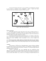
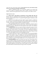
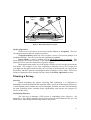
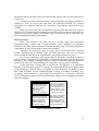
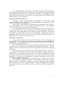
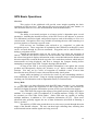
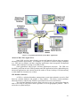
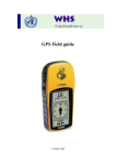
Field Guide for the Use of
Global Positioning Systems (GPS)
and
Geographic Information Systems (GIS)
for
Office for the Coordination
Of
Humanitarian Affairs
DRAFT
In cooperation with and produced by the
International Center for Remote Sensing Education
Table of Contents
Introduction ____________________________________________________________4
How to Use this Guide ___________________________________________________ 4
What is GPS?___________________________________________________________4
Overview_____________________________________________________________ 4
Common Applications ___________________________________________________ 6
How does GPS Work? ____________________________________________________6
Overview_____________________________________________________________ 6
Signal Acquisition ______________________________________________________ 7
Accuracy_____________________________________________________________ 7
Differential Correction __________________________________________________ 8
Modes of Operation _____________________________________________________ 9
Navigation Mode __________________________________________________________________9
Survey Mode _____________________________________________________________________9
Planning a Survey _______________________________________________________9
Overview_____________________________________________________________ 9
Establishing Objectives __________________________________________________ 9
Mission Planning______________________________________________________10
Data Dictionaries______________________________________________________11
Ke y Instrument Settings ________________________________________________12
Map Display Coordinates and Units _______________________________________12
Supporting Information and Tools ________________________________________13
Equipment Considerations ______________________________________________13
GPS Basic Operations ___________________________________________________14
Overview____________________________________________________________14
Navigation Mode ______________________________________________________14
Survey Mode _________________________________________________________14
Data Collection _______________________________________________________15
Data Transfer ________________________________________________________15
Data Processing _______________________________________________________16
Data Export__________________________________________________________16
GPS Data Management__________________________________________________16
Overview____________________________________________________________16
Organizing Data ______________________________________________________16
2
Me tadata____________________________________________________________17
GIS Overview and Location Applications____________________________________18
Introduction _________________________________________________________18
Basic Applications _____________________________________________________18
Advanced Real -Time Applications_________________________________________19
GIS Database Structure_________________________________________________19
GIS Database Elements _________________________________________________20
Integration of GPS and GIS ______________________________________________20
Overview____________________________________________________________20
GPS and GIS File Formats ______________________________________________20
Importing GPS Data ___________________________________________________20
List of Figures _________________________________________________________21
Acronyms _____________________________________________________________21
Contacts ______________________________________________________________21
Internet Mapping Programs _____________________________________________22
Reference _____________________________________________________________22
3
User notice: While the information within this guidebook is organized in a logical
manner, it is suggested that the entire document be reviewed thoroughly before initiating
a GPS survey. Not all GPS receivers operate the same, so it is also suggested that the
user thoroughly review the user manuals that accompany their GPS device.
Introduction
Humanitarian and relief operations require accurate knowledge of location as a
requisite input into the planning and coordination of field operations. The technology of
satellite-based navigation, or GPS, and geographic information systems (GIS) combine to
give field personnel full command of the locations and distribution of populations, roads,
distribution centres, and key facilities for all logistics, analysis, and planning activities.
This field guide provides a basic overview of the operations for GPS and the methods for
transferring coordinate data into computer mapping systems or GIS.
How to Use this Guide
An overview GPS (from Global Positioning Systems) is provided to introduce the
systems components and demystify the functional components of this technology. Field
officers will learn some fundamental insights regarding planning for the use of GPS in
surveys and methods to handle the data gathered from the field. Using the guide as a
reference, the field officer is expected to read the user manual for any specific brand of
GPS hardware and become familiar with the custom operations of that hardware. This
guide provides a framework for field operations using these technologies with references
for further technical assistance.
What is GPS?
Overview
Global Positioning Systems, or GPS, are surveying and navigation systems that
allow the user to obtain, view, and store precise information about geographic positions
on Earth. Advances in GPS software also allow for precision navigation over roads or
off-road terrain.
The main component of any GPS is the network, or constellation, of satellites that
orbit the Earth and constantly transmit encoded radio signals that can be detected by usercontrolled instruments. The Navigation Satellite Timing and Ranging network
(NAVSTAR) is deployed and administered by the U.S. Department of Defense.
Construction of a second satellite constellation for GPS is sponsored under the European
Galileo system.
4
EARTH
Figure 1: GPS Satellite Constellation
Besides the satellite array, there are several key hardware components in a GPS:
Ø
Ø
Ø
Ø
Receiver
Antenna
Data Device
Power Source
A software program that permits data download, viewing, editing, and exporting
usually accompanies these key hardware components. GPS receivers are designed to
acquire the radio signals that are transmitted from these satellites and process that data
into coordinate values.
The antenna is generally connected to the Receiver and Data Logger via cables,
but some antennas are combined in a common housing with the other hardware
components. Some modern GPS equipment use wireless technology to connect the main
hardware components. A range of GPS receivers from simple handheld units to higher
precision backpack units will be encountered in the field.
The Data Device is a small computer-like element that stores and displays the
collected data. This device can be an actual computer, but more often is a lightweight,
handheld data-logging instrument that includes a digital display screen, keypad functions,
and connections to the Receiver component.
Power Sources vary depending upon the type of receiver being used, and the
location of use. Many modern GPS receivers use internal batteries that can be easily
replaced. Larger receivers may require more substantial batteries that can be recharged,
or support direct electrical sources as from vehicle batteries.
These GPS hardware elements are collectively referred to as “the GPS receiver,”
are controlled by the user, and are carried together in a housing unit or pack that can be
easily carried by an individual.
5
ANTENNA
RECEIVER
SCREEN
DATA
LOGGING
DEVICE
POWER
SUPPLY
KEYPAD
Figure 2: Key Hardware Components of a GPS
Common Applications:
GPS is used for land, sea, and air applications. Depending upon the objectives of
the user, GPS can be used to survey and collect data, or to navigate to a predetermined
location.
GPS receivers are used to support a variety of primary data collection projects and
advanced applications. These efforts may include:
Ø Scientific Sampling (water, soil)
Ø Public Health and Safety (mine fields, disease vectors, epidemic locations)
Ø Resource Mapping (water, firewood)
Ø Survey Monument Recovery
Ø Property Boundary Surveys
Ø Aircraft , Ship, and Vehicle Navigation
How does GPS Work?
Overview
GPS data are collected through a relatively simple, but practical manner. The
receiving elements of the GPS (see Figure 2) acquire the radio signals from several
discrete satellites and through basic geometric principles (triangulation) compute the
current location of the GPS antenna.
To complete this calculation, two basic pieces of information are required; the
location of the satellites relative to the receiver, and the distance that each satellite is from
the receiver.
The radio signals that are sent include information about which satellites are
transmitting, and where they are positioned in their orbit. Once the satellites are
identified and positions are known, high precision clock data are used to calculate the
precise distance between the receiver’s antenna and each satellite.
6
Once the transmissions from three or more satellites are simultaneously acquired
by the receiver, a position can be triangulated. Figure 3 depicts the basic
communications and calculations required for GPS to operate.
SATELLITE
ARRAY
TIME/DISTANCE
CALCULATIONS
CONTROL
SECTOR
USER
SECTOR
Figure 3: Basic GPS Communications
Signal Acquisition
M ost GPS applications require data that provide a basic coordinate position (i.e.,
X and Y). This requires a minimum of three (3) discrete satellites, plus the receiver.
Some GPS applications may also require elevation data (X, Y, and Z), in which case a
minimum of four (4) separate satellites are required.
Generally receivers have between six (6) and twelve (12) “channels” which allow
them to track and accept signals from numerous satellites at once. It is best to operate the
GPS receiver with a minimum of four (4) satellites in view, or line of sight to the
receiver.
Once the necessary satellite signals are acquired, which may take a few minutes,
the receiver computes the current position (based on the location of the antenna), displays
those same coordinates on the screen, and if prompted by the user, stores the data for later
use.
Accuracy
The accuracy of a GPS receiver is dependent upon a variety of factors, including
the quality and precision of the internal electronics, the combination of satellites that are
visible at a given time/location, the presence or absence of a correction signal, and the
knowledge/alertness of the user.
Accuracy requirements may vary depending upon the application being
addressed. For example, if the features being surveyed are the location of towns that are
hundreds of kilometers apart, then the accuracy requirements are different from that for a
survey of mine fields outside a city. However, it is strongly recommended that the user
7
acquire the most accurate data possible. The determined accuracy and method should
always be recorded in the metadata documentation.
While in autonomous mode (i.e., no correction applied), most modern GPS
receivers are capable of calculating positions that are within 5-10 meters of the actual
location. With correction applied, these accuracies can improve to less than1-5 meters.
Differential Correction
GPS receivers can operate in autonomous mode, meaning that they run
automatically with no adjustments made by the user or inputs from other electronic
devices. However, autonomous mode will not produce position data as precise as that
generated through signal correction. For general navigation purposes autonomous mode
may be sufficient.
Because of some inherent (and some induced) signal corruption, a method has
been devised to correct and adjust the position values, resulting in more accurate data for
the user. Signal correction may be desired if the application requires very accurate data
(<5 meters) or real-time navigation and data recording are needed.
This signal adjustment process is referred to as “differential correction” and can
be applied under a real-time or post-processing scenario. Figure 3 depicts the principle of
differential correction. Differential correction applications often require some additional
planning considerations.
In addition to the GPS receiver and the satellites, differential correction involves
the use of another GPS receiver that is fixed at a known location. This GPS receiver is
known as the “reference station” or “base station.” The exact coordinates and altitude of
this base station receiver are precisely measured and recorded. Any differences between
the satellite derived positions and the known position of the reference station are then
broadcast via radio signals, and also recorded in digital file format.
Real-time differential correction is enabled through the use of a special antenna
attached to the roving receiver. These types of receivers are called differential GPS or
DGPS. This antenna is capable of acquiring the correction broadcast from the base
station and applies this correction factor to the incoming satellite data. This allows the
data recording device to automatically display and save the correct positional data. This
process is ideal for real-time navigation applications, or for users that do not have access
to post-processing utilities.
Post-processing differential correction does not require any special antenna, and is
designed to apply the signal correction factor after the data collection is completed. The
same principle is used, although data files from the reference station have to be retrieved
before post-processing can be performed. This method of correction is often employed
when real-time updates are not required, the user has reliable access to Internet-accessible
base station data files, and other data processing procedures are planned.
8
SATELLITE
ARRAY
CORRECTION FACTOR
BROADCAST
BASESTATION (KNOWN
POSITION)
FIELD RECEIVER (UNKNOWN
POSITION)
Figure 4: Basic Differential Correction
Modes of Operation
GPS receivers can operate in two basic modes, survey or navigation. The user
can alternate between the two options as needed.
Navigation Mode permits the user to follow a series of on-screen prompts to a
predefined location. The on-screen data are continuously updated.
Survey Mode is used to conduct projects when data capture is required. This
mode displays the current location of the antenna (and presumably of the user), and
allows the user to save the coordinates of specific features.
Many applications make use of the ability of GPS receivers to toggle between the
two modes. For example, if you were conducting a multi-day survey over a large area
you might use navigation mode to find your way back to the last point you surveyed the
day before, and then continue collecting data after switching to survey mode. These two
modes of operation will be described in more detail in the Basic Operations section.
Planning a Survey
Overview
Before beginning any project involving GPS technology it is important to
thoroughly research and plan out the steps that will be involved in meeting the objectives.
A well planned project enables the user to anticipate problems, be more efficient during
the data collection phase, maintain better organization, and assesses the progress or
success of the effort.
Establishing Objectives
The first step in planning a GPS project is establishing clear objectives. By
answering a few simple questions about project elements and limitations the user can
define clear, achievable goals that bring value to the project.
9
The user needs to understand the practical aspects and logistics of the project, and
be aware of the tactical considerations – all of which help them with improved decision
making.
At minimum the user should be able to answer the following questions about their
project:
Ø Where will the survey be conducted?
Ø What type of GPS receiver(s) will be used?
Ø What features/attributes will be collected?
Ø Where is the nearest reference station, if any exist?
Ø What supporting resources are available?
Ø Who is the audience for the final data or how will the data be used?
In addition to the logistical considerations the user should be aware of other
aspects. For example, the user should understand the timeframe, resources available, and
identify the other personnel (within or outside of the one’s organization) that will be
involved in the project. Established project planning tools, such as Gant charts should
always be employed to display each step in the planning process.
Understanding the flow of data from the initial collection through the final
processing and use is critical to project success. Figure 5 depicts the general flow of data
in a typical GPS project.
ASSESSMENT OF
OBJECTIVES
REAL WORLD
ENTITY
DIGITAL
FEATURE
PLAN
DETERMINE DATA
REQUIREMENTS
ASSESS
CORRECTION AND
EDITING
MANAGE
PROJECT
FLOW
DATABASE
ELEMENT
IN SITU DATA
ACQUISITION
SURVEY
QUALITY CONTROL
AND ARCHIVING
USE
INTEGRATION AND
ANALYSIS
Figure 5: Flow of Data in a GPS Application
Mission Planning
Depending upon what type of GPS hardware is being used, the accompanying
software may permit the viewing of pre-survey data that can improve efficiency. This
process is referred to as “mission planning” and enables the user to view the optimal
times and locations for GPS data collection. Check the user manual that accompanies the
GPS receiver to see whether mission planning software is provided.
As part of its signal, each satellite transmits almanac information about where it
will be located any given time. When analyzed in the appropriate software, this almanac
10
information allows the GPS receiver to determine the optimal times for data collection in
a given area.
Usually the mission planning software will provide data showing the number of
satellites in view at a given time and place, the predicted precision of a specific
configuration of satellites, and provide “sky plots” showing the orbital path of the
satellites.
Ideally, the user can use this information to plan the time and location for specific
GPS projects. By identifying the optimal times for data collection the user minimizes the
amount of time spent waiting for adequate signals, and can recognize when there are
inherent degradations in the signal quality.
Data Dictionaries
M ost GPS receivers will allow the user to input some brief descriptive
information about a feature that is being recorded. These “attributes” are important
elements of any GPS survey and can be recorded internally on the GPS itself or through a
combination of collection methods as part of the metadata.
Attributes are descriptive terms or values that are associated with a specific
feature. Attributes help to annotate maps, and allow data users who were not directly
involved with the GPS survey to understand the composition of the survey area.
If you were conducting a GPS project that was designed to record the location of
remote villages it would also be worthwhile to record some descriptive information about
each place. For example, you might choose to include information about the number of
people living there, how many buildings the village has, and any general comments.
If the GPS data is being used to support the development of a geographic
database, or will be analyzed later it is strongly recommended that the user consider using
a data dictionary. Figure 6 shows an example of a data dictionary. It should be noted
that a data dictionary can be recorded through a variety of methods, including voice
recordings, field notebooks, or other digital recording devices. Therefore, even GPS
receivers that do not support internal data dictionary modules can be combined with other
collection methods.
ENTITY NAME: ROAD
FEATURE TYPE: LINE
ROAD NAME: ROUTE 32
SURFACE: ASPHALT
WIDTH_MT: 6
LENGTH_KM: 41.2
COMMENT: PASSABLE
This portion of the example
data dictionary indicates
how a linear feature (in this
case a road) would have
attributes assigned. The
example shows a road that
is paved and passable.
ENTITY NAME: TOWN
FEATURE TYPE: POINT
TOWN NAME: OAKVILLE
POPULATION: 2300
PUBLIC WATER: YES
PUBLIC SEWER: YES
COMMENT: STABLE
This portion of the example
data dictionary indicates
how a point feature (in this
case a town) would have
attributes assigned. The
example shows a town that
has functioning utilities.
Figure 6: Data Dictionary Example
11
Key Instrument Settings
There are several key instruments settings that may be available to the user,
depending upon the receiver being used. These parameters are usually adjustable through
the internal software interface that comes with GPS receivers.
While this document is not designed to provide explicit instructions on every
aspect of GPS operations, it is worthwhile to mention several of the critical settings that
can have an impact on the quality and accuracy of the data being collected.
Many of these system settings are dynamic and can be adjusted by the user while
still in the field. It is strongly recommended that the user become familiar with the
function of all of the primary settings and how to adjust them before undertaking a formal
GPS survey or attempting to navigate with the GPS.
Some of the key settings that a GPS user may encounter are: PDOP (positional
dilution of precision), SNR (signal to noise ratio), horizon mask, update rate,
altitude/elevation, and display units and coordinates. Being aware of these settings and
how they function can make a significant difference in the success of a project.
M ost GPS receivers allow the user to collect numerous “positions” for a given
location, and then average these points before recording the data. If time and conditions
permit this averaging function to be used, it is generally considered to be a more accurate
method of data collection.
Depending upon which GPS receiver is being used, there may be additional
system settings that can be defined before data collection begins. Consult the operations
manual that is provided by the GPS manufacturer for more details.
Map Display Coordinates and Units
GPS receivers display and record data using sets of coordinates that correspond to
some place on (or above) the surface of the earth. These coordinates can be related to
numerous map projections. Projections are representations of the 3-D Earth’s surface on
a 2-D grid. Projections vary depending upon the needs of the user and may be influenced
by the international history of cartographers in a country. Datums refer to the established
point of origin for a particular grid.
Data from the GPS satellites is designed to deliver coordinate data relative to the
World Geodetic Survey of 1984 (WG S-84). During the process that exports data from
GPS unit to a computer, the user can convert from this default datum to a wide range of
projections and datums. This is often necessary to accommodate integration of new GPS
data with existing map data. It is suggested that the user become familiar with the
common map projections/datums used in the area and note these in a field log before
starting a GPS project.
M ap display units are used to inform the user about their relative position at a
given time and place. This is of particular interest if the GPS is being used in navigation
mode, so that the user can judge how far to travel to reach the destination. The most
common units are meters or feet.
M ost GPS receivers allow the user to adjust the map display units (i.e., meters,
feet), projection and datum. It is important to remember that these parameters are only
for the display, the actual data is being recorded within the GPS computer in WGS-84
meters.
12
It is important to know fully aware of what datum, projection, and map units are
being displayed on the GPS screen. This helps the user to integrate that information with
other supporting documents, such as paper maps, field notes, or geographic database
elements. Many mistakes have been made in the field through lack of attention to the
units be used by specific equipment.
Supporting Information and Tools
Although a reliable instrument and a knowledgeable user can make a GPS
receiver a valuable tool, it is always recommended that the user complement the GPS
with other navigation and mapping tools.
Paper maps, a field notebook, a reliable compass, knowledge of the work area,
and a communication device (e.g., cellular phone) provide the user with additional
resources to help support a safe and effective GPS project.
The knowledge that the user has about the area being surveyed or navigated can
be crucial to project success. If the user has never been in the region before, they can use
existing maps, aerial photographs (refer to Remote Sensing Field Guide), and written
descriptions to provide them with some basic information. Knowing the degree of
topographic relief and land cover types that will be encountered in the project area can
help prepare the user for a more effective survey.
Equipment Considerations
Along with the physical characteristics of the land, such as topography and
dominant land cover it is useful to know the common weather patterns and conditions in
the study area. This can help the GPS user better prepare for time in the field, especially
with regard to protecting their GPS.
The GPS manufacturer should supply specifications regarding the environmental
conditions (i.e., level of moisture, temperature) that the equipment can endure. The user
should be familiar with these limits so that the equipment is protected from damaging
conditions.
Safety should be the paramount concern when conducting any type of field work.
For example, if your GPS has an external antenna mounted on a range pole then you
should not be using it during an electrical storm. Also, while navigating, be aware that
the shortest route between two points may not be the safest or even feasible. Again
knowledge of the terrain and communication with other organizations in the field is
important to conducting a safe survey.
Other equipment considerations include planning for a reliable source of power
(e.g., spare batteries), ensuring the security of the equipment, and locating a nearby
reference station. Remember to maintain an inventory and bring along supporting
hardware accessories such as data transfer cables or battery recharging devices. Missing
gear, especially those easily stolen small items, can thwart the best planned field
missions.
13
GPS Basic Operations
Overview
This section of the guidebook will provide some insight regarding the basic
operations of GPS receivers. Note that not all receivers operate in the same manner, so
care should be taken to review the documentation from the manufacturer.
Navigation Mode
The ability to accurately navigate to a known point is dependent upon several
parameters, including the internal accuracy of the GPS receiver, the absence or presence
of a differential correction signal, and practical aspects such as the ability to cross over
certain terrain. Navigation can be very valuable in assisting the user while returning to a
previous location, or retracing a specific route.
GPS receivers use coordinate pairs referred to as “waypoints” to guide the
navigation process. These waypoints are uploaded to the GPS data recording device and
can be accessed through key driven commands. Waypoints can be entered before or
during a navigation session.
Through the navigation menu on the screen, the user selects the waypoint of
interest. Since the GPS receiver knows its current location, and it knows the location of
the selected waypoint it displays information on the screen that indicates the distance and
direction required to reach the desired waypoint. Be certain that you know which units of
measurement are being displayed, and how to interpret the compass bearing before
attempting to navigate in the field. Compass bearings shift and drift.
As long as the GPS is receiving satellite information it can update the current
position and subsequently display the “distance to go” before reaching the desired
location. You may set up a series of waypoints to establish a route of travel that
describes the most effective course with convenient safety check points.
Again, while navigating it is critical to be aware of your surroundings and have
some knowledge of the terrain. Using an existing topographic map or aerial photograph
can help you avoid obstacles such as impassable terrain, or restricted areas.
Survey Mode
The survey (or data collection) mode that GPS units can enter is very important
for projects that require the acquisition of data in the field. These data can then be
analyzed in digital geographic information systems (GIS) to provide decision support.
Some GPS units only support the capture of waypoints and one simple descriptive
attribute. For example, a pair of coordinates (X,Y) and the attribute “Village 123” might
be recorded (see Geo-Codes Field Guide). Other GPS units are capable of storing
multiple attributes, in addition to 3-D coordinate information (X,Y,Z). These more
advanced units generally support the use of data dictionaries (described in Planning a
Survey section).
The majority of GPS units permit the user to select survey mode through the main
menu of the internal software. The user can then begin collecting data, assuming that
sufficient and current satellite signals are being received.
14
Data Collection
Data collection is relatively simple using GPS, but there are some basic
considerations to remember.
Plan the survey to maximize data collection time. Acquiring the position of
features is the single most important and valuable piece of information that can be
recorded. Using mission planning, or designing a survey route that minimizes
backtracking can improve the efficiency of the project.
It is important to understand that the data being collected will eventually be used
in a GIS database or for some mapping application. By their very nature maps are
graphic representations of reality. This simplification of reality requires the use of
appropriate symbology (i.e., map graphics).
There are three basic formats that can be used to depict real world features on
maps: points, lines, and polygons. Through a combination of these three basic data types
any features can be depicted on a map. For example, a point can represent the center of a
village, a well, or a building location. Similarly, a line can represent a road, a river, or a
property boundary. A polygon is used to represent area features such as a lake, or a
minefield.
Fundamentally, all GPS receivers collect data as points (i.e., coordinate pairs).
Many GPS units are capable of collecting features as lines or polygons (areas) also.
Essentially, these data are collected as points that are automatically connected by the GPS
as the user walks or traverses the feature.
It is also important to record any attributes that are associated with a feature at the
time of the initial GPS collection. If your GPS unit supports digital collection then these
attributes can be entered while the coordinate data is being collected. Alternately, you
can provide a description in a field notebook and append this information to the
coordinate data after the data is downloaded. If you choose this latter method you must
use some reliable method of maintaining the association between the digital coordinates
and the written attributes.
Data Transfer
Data transfer refers to the process of retrieving from or providing data to the GPS.
This process enables the user to ultimately use and analyze the data in other formats,
subsequently realizing the value of the data that has been collected for mapping,
planning, and reporting.
Such transfers are usually accomplished by means of a data transfer cable
connected to the device ports and facilitated by the user through a software interface.
Data upload refers to the transfer of digital data from a source computer or device
to the GPS data recording device. Transferring waypoints or basic background map data
to the GPS are examples of uploading.
Data download refers to the transfer of digital data from the GPS unit to a
receiving computer or device. Transferring point, line, or polygon features are examples
of data download.
Refer to the software manual provided by the GPS manufacturer to ensure that the
data transfer process is properly executed. Improper hardware or software setup can lead
to the loss of very valuable data. After a data download it is essential to copy the data
and store this backup in a safe and secure place.
15
Data Processing
After data is downloaded from a GPS unit the file(s) may be subjected to several
processing routines, including post-processing differential correction, attribute editing,
and reformatting. At this point it is critical to stay cognizant of data management and file
organization (see Data Management section, below).
Post-processing has already been described in How Does GIS Work section.
M ost GPS software applications will permit the user to edit feature attributes, delete or
add points as needed, and reformat the raw data so that it can be used in standard GIS
applications.
GPS software programs allow the user to view data on a computer monitor with a
window driven menu and commands. Zoom, pan, and inquiry tools are provided, and
some fundamental database editing is permitted. One key aspect of the processing is to
export the data in a projection and datum (and in the proper units) to integrate it with
existing data.
Data Export
Exporting data in a format that can be used in a GIS is generally the last step in a
GPS project. Most GPS software programs provide the user with multiple file format
options to choose from during the export routine. Again, it is imperative to know what
the incoming map projection, datum, and units are so that the proper conversion factors
can be applied (if the user is exporting data in another map projection).
Exporting data from a GPS software application is a critical step in realizing the
value of the information that has been collected. Therefore, it is important to maintain
excellent data management practices when performing this routine. Refer to the software
manual provided by the manufacturer to become familiar with the exact export routine
commands.
GPS Data Management
Overview
Besides determining very accurate position data, one of the greatest advantages of
the GPS is that it records data in digital format. This saves precious time normally
required to manually enter field notes into a digital database. However, this value ability
also requires that the user understand some basic data management principles.
Organizing Data
Any successful GPS project employs reliable and sustainable data management
practices. Digital data management can be made very easy with the tools available in
most standard file management systems, but a well planned and executed set of
procedures is essential to keeping the process efficient and error free. The GPS user
should be directly involved in the data organization process. It is best to prepare a file
directory structure before beginning any data collection project. This will help the
project personnel to “visualize” the data process and save time after the data has been
collected.
Basic data management principles should be observed when organizing any
digital data files. The directory structure and file folder naming conventions should be
16
intuitive and consistent. Data should be backed up and archived through set procedures
that occur at specified time intervals. Ensuring data security is paramount, so it is
recommended that backup copies of all files be created and stored in a separate location.
While exporting data it is important to keep files well organized so that the raw
GPS data does not get combined with the processed data. This is easily accomplished by
creating separate folders for raw, processed, and exported data formats. A few extra
folders take up very little computer memory and can save precious time spent
reorganizing mixed data.
Data management responsibilities should be shared by all project participants, and
standard practices and procedures should be discussed with all staff, documented and
posted for reference. Sound data management may also help the user assess project
success or flaws.
Metadata
One other aspect of data management that is critical to the long-term
sustainability of a data set is the creation of metadata (see Geo-code Field Guide).
M etadata is a text file that contains descriptive information about a data set. This
metadata file provides key information about the parent data set, such as when the data
was collected, a point of contact for questions, the format of the data, and the purpose of
the data.
M etadata standards have been established for nearly a decade and should be
considered part of a data set. GPS data files that do not have accompanying metadata
should be considered incomplete and untrustworthy. Metadata helps others that are
unfamiliar with a data set to quickly understand the content and purpose of the parent
data set, and serves as a reliable source of documentation regarding the origin and
originator of the positional datasets. The only way to maintain and communicate the
quality or fitness of a dataset is with metadata. Properly applied, metadata for a
coordinate survey can enable the data widespread use among many organizations for
literally decades.
17
GIS Overview and Location Applications
Introduction
Geographic information systems (GIS) have evolved over the past 30 years to a
point where they dominate all other command and control systems for accurate display
and management of the landscape and activities upon the landscape. While GIS come in
a variety of guises, their capabilities to generate maps, reports and provide practical
analytical products for planning and assessment scenarios have earned GIS strong and
loyal following throughout the humanitarian and tactical communities.
Fundamentally, GIS allow for the collection, encoding, management, analysis,
and display of spatial information. Spatial or geographic information covers most every
element of humanitarian applications. GIS have evolved to user-friendly windows-style
user interface software, which allows field personnel using laptop computers to call up
various views of the mission terrain, query the database contents for key features or
status, and to build a knowledge base about the spatial relationships (distance, proximity,
connectedness) of all elements in the field.
Basic Applications
There are myriad GIS applications and the areas of adoption are still increasing.
Primary among the applications for GIS is the ability to render a view of the mission
environment. Common applications include environmental assessments, public health
analyses, transportation and utility mapping, and land or facility management, (see Figure
7). Based on the creation and availability of a foundation or basic area database (refer to
UNHQ OCHA or HIC representative for details) the field officer can expect to easily
locate and display views of an area and select the features of interest. Field maps can
then be instantly printed and available for a day’s activities.
Mission environments can be better understood, for example, using satellite
imagery as the backdrop, using the GIS to display overlays of roads, key distribution
facilities, schools and hospitals, known hazardous areas, et cetera. Survey points can be
readily viewed with perspective on the relationship of the surveyed points or navigational
tracks to other existing features.
By linking an organization’s database of weekly or period incidences of disease
outbreaks, violence, or activities into the GIS, the field officer can quickly display the
locations of these activities and conduct spatial analysis as to relationships, causes, and
devise response or remediation strategies. Spatial analysis is the process of querying a
spatial database to highlight patterns or anomalies, or performing specialized operations
with spatial data to derive new information for decision-making. The sharing of
databases among agencies quickly creates an exponential increase in the spatial analytical
capacity for any field agent.
Perhaps one of the key benefits of GIS is the in the application of GIS as a
communication vehicle. Using the multiple ranges of “mapping” outputs of a GIS, a field
officer can more effectively communicate with local residents as well as with cooperating
humanitarian organizations.
18
Figure 7: Geographic Information Systems Basic Applications
Advanced Real-Time Applications
Some GPS receivers have display screens and internal software that can support
advanced real-time applications. For example, it is possible to connect a laptop computer
to a GPS unit to support real-time mapping applications that incorporate background
images while walking or touring an assistance zone.
Such applications often require real-time differential correction. The GPS user
should be proficient in basic GPS operations and GIS applications before undertaking any
advanced applications and caution should be made to ensure backups if life-threatening
or other high-risk situations are evident.
GIS Database Structure
A GIS is a relational database management system that maintains an active link
between a tabular database and graphic or map features. The tables contain attributes
about the features, and the map elements represent discrete real world features.
The relational database structure allows the user to query or extract data from the
table or the map to help answer direct questions or reveal geographic patterns. This is
referred to as spatial analysis.
19
GIS Database Elements
One of the advantages of a GIS is the ability to store, retrieve, and manage
numerous data formats including imagery, tables, and map features. With regard to GPS
data, the key database elements are the tables and map features. The tables contain the x,
y, and z numerical coordinates.
Although there are some inherent connections between GPS and GIS it is useful
for the GPS user to have, at minimum, a working knowledge of GIS functions and the
structure of such systems.
Integration of GPS and GIS
Overview
Generally GPS data is used to create positional accuracy of field features or
objects or update locations for field maps as stored in a spatial dataset. The processes
required to update databases that is computer maps, requires advanced data formatting
and analysis expertise in geographic information system technology.
Over the past few decades GIS has revolutionized the use of geographic or spatial
data for a wide variety of user applications. Because of the inherent link (i.e., geography)
between the two technologies, GPS is an ideal method of providing locational data about
features data (road, bridges, building, minefields, et cetera) for a GIS.
GPS and GIS File Formats
File formats for proprietary GIS applications vary, but some basic aspects remain
consistent. GPS data also fundamentally share the same format.
GPS data are stored in binary, simple text format. This enables easy transport
between different export platforms, and permits easy editing. In their simplest format,
GPS data files include an X and Y coordinate pair, and a text attribute.
GIS data are stored in a variety of formats but adhere to a structure that permits
their use in any relational database. GIS files can include links to other files, or
applications. Recall that geographic features are represented in mapping environments as
a combination of points, lines, and polygons. This requires that all GIS files contain
some inherent or associated geographic information.
Importing GPS Data
Assuming that the GPS data export routine was performed properly these files are
easily imported by a GIS through a few simple commands. Once the data has been
imported it is generally saved in the native file format of the chosen GIS software.
When importing data into an existing GIS database it is again important to know
and understand the map projection, datum, and units that are being used. Without this
information, data will not overlay properly corrupting relative spatial relationships.
20
List of Figures:
Figure 1: GPS Satellite constellation
Figure 2: Key Hardware Components of a GPS
Figure 3: Basic Elements of GPS Communications
Figure 4: Basic Differential Correction
Figure 5: Flow of Data in a GPS Application
Figure 6: Data Dictionary Example
Figure 7: Geographic Information Systems Basic Applications
Acronyms:
DGPS
GIS
GPS
HIC
NAVSTAR
OCHA
PDOP
SNR
UNHQ
UTM
WGS-84
Differential Global positioning systems
geographic information systems
global positioning systems
Humanitarian Information Center (United Nations)
Navigation Satellite Timing and Ranging
Office for the Coordination of Humanitarian Affairs United Nations
Positional dilution of precision
Signal to Noise Ratio
United Nations Headquarters
Universal Transverse Mercator
World Geodetic Survey of 1984
Contacts
http://www.colorado.edu/geography/gcraft/notes/gps/gps_f.html An Overview of the
Global Positioning System. , developed by Peter H. Dana, The Geographer's Craft
Project, Department of Geography, The University of Colorado at Boulder.
http://www.aero.org/publications/GPSPRIMER/ GPS Primer, downloadable
http://www.trimble.com/gps/ Trimble GPS Tutorial
http://www.gpsy.com/gpsinfo/ The Global Positioning Systems (GPS) Resource Library
http://degaulle.hil.unb.ca/Geodesy/CANSPACE.html CANSPACE. M aintained by Dr.
Richard Langley, professor, University of New Brunswick Department of Geodesy and
Geomatics Engineering, and contributing editor, GPS World Innovation column:
http://www.topconps.com/Tutorial/index.html GPS Tutorials and Information:
21
Internet Mapping Programs
http://www.aquarius.geomar.de/omc/omc_intro.html: Online Map Creation You may
create maps interactively at this site.
http://www.esri.com/base/data/online An extensive online database of geographic data
and a mapping engine
http://mapfinder.nos.noaa.gov National Ocean Service MapFinder Home page, provides
direct Internet access to primary NOS imagery and data holdings
http://alexandria.sdc.ucsb.edu The Alexandria Digital Library, links to significant
collections of geospatially referenced information
Reference
Harder, Christian. 1998. Serving Maps on the Internet; Geographic Information on
the World Wide Web. Redlands. Environmental Systems Research Institute, Inc.
Hoffmann-Wellenhof, B. H. Lichtenegger, and J. Collins. 1994. GPS: Theory and
Practice. 3rd ed. New York: Springer-Verlag.
Kaplan, Elliott D. ed. 1996. Understanding GPS: Principles and Applications.
Boston: Artech House Publishers.
Leick, Alfred. 1995. GPS Satellite Surveying. 2nd. ed. New York: John Wiley &
Sons.
National Imagery and Mapping Agency. 1997. Department of Defense World
Geodetic System 1984: Its Definition and Relationship with Local Geodetic Systems.
NIM A TR8350.2 Third Edition. 4 July 1997. Bethesda, MD: National Imagery and
Mapping Agency.
Parkinson, Bradford W. and James J. Spilker. eds. 1996. Global Positioning System:
Theory and Practice. Volumes I and II. Washington, DC: American Institute of
Aeronautics and Astronautics, Inc.
Wells, David, ed. 1989. Guide to GPS positioning. Fredericton, NB, Canada:
Canadian GPS Associates.
22