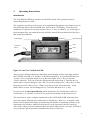
1
VOLKSLOGGER User Manual Edition 1.7.2, English 05-07-2000 for Volkslogger Firmware 3.6, Subrelease 174 Hardware 3.4 Garrecht Ingenieurgesellschaft Translation by ENTEC Technical Services, Inc. 2 Contents CONTENTS ..................................................................................................................................................................................... 2 1. PREFACE...................................................................................................................................................................................... 3 2. TECHNICAL DATA .................................................................................................................................................................. 4 3. IMPORTANT DIRECTIONS .................................................................................................................................................. 5 3.1. CARE......................................................................................................................................................................................5 3.2. SAFETY DIRECTIONS FOR INSTALLATION.......................................................................................................................5 3.3. INSTALLATION ...................................................................................................................................................................6 3.3.1. Mechanical Installation...................................................................................................................................... 6 3.3.2. Electrical Installation.......................................................................................................................................... 6 4. SHORT OPERATING INSTRUCTIONS ........................................................................................................................... 8 5. OPERATING INSTRUCTIONS ......................................................................................................................................... 9 INTRODUCTION ...............................................................................................................................................................................9 5.1. SWITCHING ON................................................................................................................................................................10 5.2. FAI-LOGGER FUNCTION.................................................................................................................................................12 5.3. SCREEN DISPLAYS .........................................................................................................................................................12 5.3.1. Navigation............................................................................................................................................................13 5.3.2. Position Information .........................................................................................................................................15 5.3.3. Menu......................................................................................................................................................................16 5.4. ACOUSTICAL SIGNALS ...................................................................................................................................................22 5.5. NAVIGATION ......................................................................................................................................................................23 Introduction .........................................................................................................................................................................23 5.5.1. Overview...................................................................................................................................................................23 5.5.2. Observation Zone (Turn Point Sector/-Cylinder/Start-/Finishgate) ....................................................23 5.5.3. Navigation Operating Modes ..........................................................................................................................25 5.5.4. Useful Functions ...............................................................................................................................................26 5.6. ELECTRONIC FLIGHT DECLARATION .............................................................................................................................29 Introduction .........................................................................................................................................................................29 5.6.1. Overview...................................................................................................................................................................30 5.6.2. Input / Editing.....................................................................................................................................................30 5.6.3. The Coordinate Template..................................................................................................................................34 5.7. BASICS OF DATA INPUT .....................................................................................................................................................36 Introduction .........................................................................................................................................................................36 5.7.1. Field Types ............................................................................................................................................................36 5.7.2. Editing of Fields ...................................................................................................................................................37 6. BACKGROUND INFORMATION......................................................................................................................................38 6.1. M EMORY STRUCTURE ......................................................................................................................................................38 6.1.1. Flight Data Memory...........................................................................................................................................38 6.1.2. Database Memory.............................................................................................................................................38 6.1.3. Flight Declaration Form Memory...................................................................................................................40 7. ADDENDUM..............................................................................................................................................................................41 7.1. SHORT DIRECTIONS FOR THE READOUT OF DATA (OFFICIAL) USING DATA-GCS.EXE: ........................................41 7.2. SETUP OF NMEA-OUTPUT ..............................................................................................................................................42 7.3. IGC-LICENSE CERTIFICATE .............................................................................................................................................43 IGC-APPROVAL FOR GNSS FLIGHT RECORDER GARRECHT VOLKSLOGGER MODEL VL1.0.......................43 ISSUE 2 INCLUDING MOTOR GLIDER ENL FUNCTION ..........................................................................................43 CONDITIONS OF APPROVAL.........................................................................................................................................44 NOTES FOR OWNERS AND PILOTS -............................................................................................................................45 PART OF IGC APPROVAL FOR GARRECHT VL1.0 GNSS FR...................................................................................45 NOTES FOR OFFICIAL OBSERVERS AND NACs -......................................................................................................46 PART OF IGC APPROVAL FOR GARRECHT VL1.0 GNSS FR...................................................................................46 2 3 1. Preface Congratulations on the purchase of a Volkslogger, one of the smallest, FAI-approved GNSS-Flight Data Recorder with integral Navigation Display. developed, produced and assembled in Germany. The Volkslogger was developed by soaring pilots for soaring pilots according to the newest guidelines of the IGC (FAI-Sporting Code, Section 3, Annex B). The System is being shipped with the following accessories: • Data Cable with a 220VDC/14VAC Power Supply/transformer (local dealers may supply locally adapted units), for Readout and Programming of the Logger by PC • Universal Cable (pigtail) for Installation in the Aircraft • User Manual • FAI-License Certificate • MS-DOS Programming and Analysis Software for IBM-PC / compatible Computer • Knurled Screw M5 for easy attchment of logger to standard Camera mounts In case your Volkslogger was not shipped with all of the parts listed above, please inform your dealer immediately. 3 4 2. Technical Data Power Supply max. 24 V DC min. 9.5 V DC integral polarity protection current consumption ca. 120 mA at 12V Operating Temperature -20°C .... + 70°C (- 4°F ….+158°F) Weight 0.3 kg (0.66 lbs) Altitude Recording GPS: max. 19470m (63,878 ft) Resolution 10m (32.8 ft) Barometric: max. 13000m (42,640 ft) Resolution at MSL: 3m, Resolution Steps double every 5,500m (18,045 ft) Temperature Error over entire Temperature Range: 2 hPa (2 mb) Coordinate Recording geogr. Longitude, geogr. Latitude, WGS-84 Format Resolution: 1/60,000° = 1.852 m (6.076 ft) Engine-Run Recording Integral acoustical Engine Noise Sensor* Recording Capacity Dependent upon recording frequency ca. 30 h at 12 sec. recording interval Mounting Three mounting threads M5 at the bottom of the instrument Do not use Camera Threads!! * starting with hardware 3.3, see label data 4 5 3. Important Directions 3.1. Care Like every electronic instrument or camera, the VOLKSLOGGER also requires proper treatment, to assure as long and as trouble-free a life span as possible. Therefore the following directions should be strictly followed ! • Do not expose the instrument to direct sunlight for extended periods of time on the ground (closed cockpit on a standing aircraft) but keep it covered (canopy cover, paper, hat, etc.). The temperatures, which black instruments in the cockpit of an aircraft on the ground can reach (far above 80° C) will eventually damage the display and also the electronic. This may lead to total failure or a shortening of the useful instrument life. • Do not store the instrument in high humidity (during the night/winter in the aircraft or trailer) since the condensation caused by the cooling can penetrate into the electronics and damage it. • Do not clean the case and display with water but only with a lint-free rag (preferably cotton) moistened (not dripping wet) with Denatured Alcohol or Ethanol. One has to be careful not to let any liquid penetrate into the instrument or damage the label/seal on the back. • Do not use ACETONE or any other harsh solvents since these destroy the labels! 3.2. Safety Directions for Installation Failure to follow the Safety Directions can cause damage to the instrument and surrounding area. • No fuse is built into the instrument. Therefore, an instrument fuse (500mA, slow-blow) has to be added during installation in the aircraft, before connection to the electrical system, to prevent fires or other damage caused by short circuits in cables or instrument. The operation of the instrument with a fuse is part of the warranty qualification. • There is no over-voltage protection integrated into the instrument. An exceeding of the stated operating voltage leads to damage of the instrument. • The instrument case is internally connected to electrical mass (negative ground). Please ensure you take this into consideration during installation. • Should the Volkslogger be rigidly connected (screwed) to parts of the canopy frame , the cable should be lead through an easily separable intermediate connector. Ignoring this statement can cause a failure of the canopy release in an emergency! 5 6 3.3. Installation 3.3.1. Mechanical Installation Due to its small size the Volkslogger can conveniently be mounted on an existing camera bracket. This allows access to all keys and easy reading of the display during flight. For attachment, the underside of the instrument case contains three holes with M5 thread (metric, 5mm) (Camera thread (1/4”-20) does not fit!!) In case no camera bracket is available, the logger, due to its low mass, can also be fastened with Velcro to the instrument console. During installation, assure that the integral antenna has a clear view of the sky and is not shielded by metal or carbon fiber parts. In case the instrument should be installed in the baggage compartment, attention must also be paid to the “clear view of the sky”. (Caution: Carbon fiber or metal parts shield the GPS reception, plastic and wood are usually not critical). To prevent accidental operation of the buttons by moving objects, the buttons can be locked. (Menu: ACT.LCK). During the time the buttons are locked, the input code for unlocking them is shown on the display. The statements for mounting instruments and antenna are also valid for instruments with external GPS-Antenna. 3.3.2. Electrical Installation Power supply and communication with PC or flight computer are achieved simultaneously over a 8-pin Western-Plug (RJ-45) on the left-hand side of the instrument. Either the PC-readout cable or the aircraft installation cable is connected to it. Caution is advised during connecting the plug of the cable. Functions of the wires on the Logger Connection Cable: brown and brown-white: Positive wire of the power supply (+12V) orange and orange-white: Negative wire of the power supply and the data line blue: Data output (PC-Communication or NMEA) green-white: Data input (PC-Communication) We remind once more about the necessary fusing of the supply voltage! The instrument should be connected to the aircraft power circuit by a qualified technician. The functions of the wires have to be strictly observed. Non-compliance may seriously damage the electronics of the VOLKSLOGGER. The operating limits given in the technical data are stated in order to avoid damage to the instrument. The instrument is internally protected against polarity reversal. Nevertheless, the proper polarity should be observed during connection. 6 7 Note: Even though the instrument itself is protected against polarity reversal, a connected flight computer can be damaged over the interface when the polarity is reversed in the VOLKSLOGGER. The VOLKSLOGGER has no internal buffer against momentary power interruptions. This has the advantage that there is no part, which deteriorates and would have to be replaced every 2-3 years by the manufacturer. Therefore, the power supply of the instrument has to be protected against momentary drops below the minimum voltage. In particular during switching of batteries such voltage drops can take place, which will lead to a separated flight record during readout. This means that the recording of the flight consists of several files, which is accepted reluctantly or not at all by the evaluator. The circuit shown is meant as an example for a buffered and fused installation. Alternately it is recommended to use a separate logger battery (Gel-Cell, 12V, 1.8 Ah), to which no other power consuming devices are connected. Circuit Diagram Note: Zum Logger = To Logger Vom Bordnetz = From Battery Felnslcherung = Fuse Figure 1: Buffered Connection to the Aircraft Power Circuit 7 8 4. SHORT OPERATING INSTRUCTIONS In the following text the operation of the instrument is described briefly. This chapter is in no way meant to be a substitute for studying the complete manual but it essentially describes the steps necessary to record a free flight, without input of the flight declaration and without the use of the navigational support by the VOLKSLOGGER. • Connect the VOLKSLOGGER to the power supply cable and mount the instrument in the aircraft (the VOLKSLOGGER does not have an On/Off – switch. Operation is started by the connection to the power circuit). • After connection to the power supply, the display of the VOLKSLOGGER shows a countdown timer. During this time a connection to a PC can be made for the purpose of data transfer. If no PC is connected, the instrument switches to normal operation mode after 9 seconds. • Wait until the VOLKSLOGGER goes through the information displays. It will show the instrument serial number, the hardware version, the firmware version and the condition of the electronic seal. • After the information pages, the VOLKSLOGGER immediately commences recording. For correct GPS-reception it is necessary to wait for the contact with valid satellite signals. The number of received satellites is shown in the lower left of the display. Only after 4 (preferably 6) satellites are received, a correct positional fix is possible. Additionally, the status of the reception is shown. See chapter 5.3.3. Navigation. • When the memory is full, the VOLKSLOGGER stops recording. Therefore, sufficient memory space has to be available for a complete record of the flight. You either have to erase the memory before the beginning of the flight (ACT.MEMCLR) or the recording interval has to be increased (CFG1.LOG.INTV) until the available recording time appears to be sufficient for the flight. If the available residual recording capacity is less than 8 hours, a (visual and acoustical) warning is unless it has been deactivated (Menu CFIG1.SND.WRN) The available capacity of the memory (Flt-MEM) can be examined in Menu INF.MEM . The remaining recording time is depending upon the number and size of the recordings of old flights still in memory as well as the selected recording interval. • After landing, transfer of the recorded flight from the logger is by means of a PC (under supervision of an official observer if necessary) for storage it on a floppy disk or other suitable recording device. 8 9 5. Operating Instructions Introduction The VOLKSLOGGER does not have an ON/OFF switch. The operation starts by connecting the power cable. The complete operation of the logger is accomplished through the use of three keys on the right-hand side of the instrument face, next to the LCD-Display. These keys are numbered in sequence from top to bottom, Key (1), Key (2) and Key (3). Lettering on the instrument face was omitted because with the many different functions of the keys that would be confusing. LCD-Display GPS-Antenna Key 1 Connector Sleeve Key 2 Key 3 Figure 2: Front View VOLKSLOGGER The keys have different functions depending on the display and the operating mode of the VOLKSLOGGER. For instance, in the menu-mode Key (1) has the function of an <escape>-key (exiting the menu-level to the next higher level). Key (2) has the <Next>-function. You can select the displayed menu-items with it. Besides this, in modes where you can change a value, Key (2) can be considered a (-) Key. Key (3) has the property of an <Enter>-Key. With it you can go to the selected menus. In the modes where a value can be changed, Key (3) has the function of a (+) Key. Every key has an auto-repeat-function, which means that if it is held depressed for a certain time ( ≥ ½ second), it acts as if it is pressed repeatedly in rapid succession. The operation of such a complex instrument as the VOLKSLOGGER with only three keys may appear difficult and cumbersome at first glance. However, it complies with the by now accepted philosophy of minimizing the number of operating elements in an instrument (for instance, modern laser printers can be operated with only one key). After only a short period of familiarization and with a little practice, the user will find it easy to operate and program the instrument by means of the keys. 9 10 Further details about the operation and the functions of the keys in the particular situations are explained in the respective chapters (in particular chapter 5.7. Basics of Data Input) 5.1. Switching On After connecting to the power supply the VOLKSLOGGER asks the user for a connection to a PC with the readout program running (Display: “waiting for PC”). Unless within 9 seconds a data connection with a PC is established or one of the keys is actuated, the instrument starts displaying a sequence of introduction screens (PC connection may also be established through the menu ACT.PC): 1. Introduction Screen Volkslogger 1.0 (c) GCS 1997-99 Instrument Type Copyright-Notice 2. Introduction Screen Serial # 06F HwR:3.2 FwR:3.5 Serial Number in base-36 Format Hardware Version, Firmware Version 3. Introduction Screen Security Seal is OK. Condition of the Electronic Seal: Security-seal is OK The undamaged condition of the seal is confirmed. The instrument has not been opened since it was sealed by the manufacturer. Or: Security Seal is not OK!!! Condition of the Electronic Seal: Seal is broken The system has determined that an unauthorized attempt at opening the instrument case has been made. It therefore has to be assumed that a manipulation on the hardware has taken place. The instrument functions remain intact but it is no longer possible to supply flight data with the required check-sum. All flight data supplied by this instrument will be recognized by the validation program as invalid and will be rejected by the FAI or National Authorities. 10 11 The instrument in question has to be returned to the manufacturer for re-sealing. Besides this, an instrument on which the seal is broken can no longer store setup data. All parameters are returned to the default values during each turn-on. After initialization has taken place and the introduction screens have been displayed, the logger goes into the operation mode and starts to do its work. 11 12 5.2. FAI-Logger Function In its capacity as an FAI-Logger, the VOLKSLOGGER continuously and uninterrupted (as long as there is sufficient memory available, see Chapter 6.1.1. Flight Data Memory) records all data relevant to the FAI/IGC: • • • • Position GPS-Altitude Pressure Altitude Engine Run / Noise Level∗ The data are recorded in certain time intervals, as soon as voltage is supplied. Data will always be recorded, even if the aircraft does not move and independent of the availability of GPS-Reception. The recording happens in the background, independent of the screens displayed, navigational modes, menus, etc. The only possibility for the pilot to interact with the recording process is in the modification of the recording cycle (logging interval adjustment, definition of the turnpoint observation zone/sector, manual activation of the fast recording, etc.). 5.3. Screen Displays In the operation of the logger you can choose with Key (1) between the main screens: • • • NAVIGATION POSITION-INFO MENU These screen names will also be used in the subsequent descriptions. On the logger itself these designations will never be displayed, rather it will be clear from the context, which screen is active at the time. In the following text, the particular display screens and the meaning of their indications are described: ∗ starting with hardware 3.3, see Type Label 12 13 5.3.1. Navigation The main navigation display screen offers all the relevant navigation- and statusinformation of the VOLKSLOGGER during the flight. It supports the pilot during the correct approach to the turn-points of the flight task and gives information about the actual condition of the GPS-reception. AACHEN 179km192° 5 } WP 75kt187° • • • ATTENTION: On this display screen the distance and direction from the actual position to the displayed way-point is shown, not the length and direction for the leg of the task. To show the information of a le, (for test or comparison purposes for instance) the function “INF.RTE” (See chapter 5.5.4.2. Route-Information) has to be called up. The angular values “Bearings” are referenced to true North, the magnetic deviation is NOT taken into consideration. Speed and track are values over ground, as they are determined by GPS. They can, depending on wind, vary substantially from the speed and heading of flight in the air. Note: • • • • • Navigation Target, Distance, Bearing (QUJ) Satellites, Status, Way-Point Type, Speed, Track Heading is the direction of the nose of the glider while track is the path of the glider over the ground. Bearing is the direction between the glider and the Navigation Target. The satellite status shows the number of received satellites, where the maximum number of 9 is shown, even though up to 12 could be received. The recording status shows whether the instrument is presently recording (blinking triangle) or whether the memory is full and the recording has stopped (blinking square). The display units for distance (km, NM) and speed (km/h, kt) can be selected in menu CFG2.UNITS.Dst and CFG2.UNITS.Spd. Way-Point Type / Navigation Mode (See also chapter 5.5.3. Navigation Operating Modes) • WPT: Navigation Operation Mode Single Point • RTE: Navigation Operation Mode Route • HM: Home Airport • ST: Start Point • TP: Turn-Point • FN: Finish Point • PT: Single Point (See chapter 5.6.3. The Coordinate Template) GPS-Failure: In case the GPS-Reception conditions are too poor for a positional fix, the satellite status display starts blinking. The values for speed and heading will be, since they are determined by GPS, blanked out and replaced by lines. 13 14 Key Functions in the Navigation Screen: (1) Switches to display screen “POSITION INFORMATION” (2) Selects the next way-point of the active navigation route (3) Places a marker in the position record after confirmation of the safety question (is stored separately in the IGC-file as PEV-data-set with time and position). The existence of a marker function is increasingly becoming a requirement for the approval of flight data recorders (loggers) in competitions. 5.3.2. Position Information The display screen “NAV.POS” contains some information, which during the flight is less meaningful and does not have to be permanently displayed in the main navigation display screen. The actual position determined by GPS can for instance be useful after a land-out to be able to give it to the retrieve crew. The position is logged when the NAV.POS screen is entered and will be shown in the Navigation screen with the name “MEMORY”. This feature may also be used to mark a thermal. The altitude indication, which is derived from the cockpit pressure, is a useful additional instrument if used properly. It can for instance, if displayed in feet and set to standard pressure, show the flight level directly to avoid entering limited flight access areas or class C airspace. 589ft 51N02.072 13:42 007E34.643 • • • • Altitude, Geographic Latitude UTC Time, Geographic Longitude The display unit for altitude can be selected in menu CFG2.UNITS.Alt The altitude value shows the barometric determined altitude, using a certain altimeter setting. The reference pressure level is 1013.25 mb after starting the instrument but can be changed during the operation. (See below). This has however no bearing on the recorded altitude, which is always determined using the reference level of 1013.25 mb. Longitude and latitude are displayed in 1/1000 minute of angle after the decimal point. The displayed coordinates are presented just as the integrated GPS-receiver supplies them. If no valid signal is available, the last valid position is displayed. The display of the time is in UTC Key Functions in the Position Screen: (1) (2) (3) (2)+(3) Advances to display screen “Menu” Increase of the displayed altitude by 3m Reduction of the displayed altitude by 3m Returns the altimeter to default setting (reference level 1013.25 mb) 14 15 Pointer: The simultaneous pressing of Keys (2) and (3) is very time-critical and may perhaps require some practice. 5.3.3. Menu Introduction The menu display screen is the actual user surface of the VOLKSLOGGER. The menu (choice) is structured hierarchically; the individual menu-points are sorted in order of importance. The menu display screen has the following structure: Example Main Menu: /1 } NAV•INF•FAI•ACT • • Menu Description Menu Abbreviations, one of them marked (arrow) After selection of the menu display screen the highest level is generally shown (main menu). Behind the menu description , for multiple page menus, the presently shown page is indicated (in the example Page 1 of the main menu) The exact meaning of the individual abbreviations is explained in the following section. Key Functions: (1) (2) (3) Switches to the next higher menu level. If you are in the main menu, the navigation display screen is activated. Moves the marker arrow to the next menu abbreviation. If necessary, the next page of the menu is shown. Executes the marked (selected) menu point. Depending on the meaning of the menu abbreviation, a sub-menu is activated or a function is carried out. For a simpler presentation and description, menu points are always shown in the following way: MENU.SUB-MENU.xxx.xxx.xxx For instance: CFG1.LOG.MRK Sub-menu MRK (Marker-Duration), from sub-menu LOG (Record), from sub-menu CFG1 (Configuration), from main menu. 15 16 The methods for input of values in the different menus (CFG1, CFG2, FAI) are covered in detail in chapter 5.7. Basics of Data Input. 16 17 Menu Structure The main menu consists of the following points: NAV, INF, FAI, ACT, CFG1, CFG2, the sub-menus and functions are as follows: NAV: Navigation – Setup of the navigation operating method (See Chapter 5.5. Navigation): DCL: POS: WPT: EMR: RTE: DRC: Resume NAV display of active Flight Declaration Current (Actual) Position Navigation Point from Database Select for Emergency Landing Fields Select Route from Database Free Change of Actual Navigation Target INF: Information about MEM: Memory Shows the remaining recording time and the capacity of the Flight Declaration Form Memory (See chapter 6.6.1. Flight Data Memory and 6.1.3. Flight-Declaration Form Memory). BAT: Battery Voltage Shows the actual value of the Supply Voltage VL: Shows the Volkslogger Introduction Screens (See Chapter 5.1. Switching On). RTE: Navigation Route Overview over the currently selected Route (See Chapter 5.5.4.2. Route Information) FAI: Flight Declaration (See Chapter 5.6. Electronic Flight Declaration) EDIT: Fill out or change Flight Declaration Form INFO: Change Flight Information PILOTS NAME (1) Name of the Pilot, Part 1 (first 16 Letters) PILOTS NAME (2…4) Further Letters of the Pilot’s Name, if 16 Letters were not sufficient AIRCRAFT REG Aircraft Registration Letters AIRCRAFT TYPE Aircraft Type COMPET-NUMBER Competition Number COMPET-CLASS Competition Class HOME POINT Home Airport / Start Point 17 18 TASK: Copy Route from RTE-DB? (Y / N) Edit Task: NUMBER OF TPS: Number of Turn Points START-POINT: Start Point = First Scoring Input Point of a Route TURNPOINT 1..12: Turn Points between Start Point and Finish Point FINISH-POINT: Finish Point = Last Scoring Input Point DECLARE: Register Flight (“Photograph” of the Declaration Form) ACT: Action MEMCLR: Erase Flight Data Memory completely. Erases the flight data memory (after Double Safety Question). During the erasure, ALL Flights stored in the memory are erased. The Databases and the Flight Declaration Form are not affected by this operation. LCK: Key Lock Activates the key lock for the instrument, to prevent accidental inputs. The keys are unlocked by input of the key sequence shown during the locked condition. The actually necessary key pressure is indicated by a blinking cursor. PC: PC Communication Activates the PC communication of the logger. This is a separate operating mode, which cannot run in parallel with the recording of data and therefore terminates the recording into the file. CFG1: Settings: LOG: Logging Parameters INT: Recording Interval Range: [1s…60s] Recording Interval outside of the turn-point zone. Additionally the time remaining in the memory at this interval is calculated and displayed in the lower line. MRK: Marker Duration Range: [0…30] Number of valid fixes, which are recorded in the fast fix (1s) mode after pressing the Marker-Key, before switching back to “normal” recording interval. OZ: Sector-Dwell Time Range: [1…30] Number of valid fixes, which must be recorded after entering the turn-point area in the fast recording mode (1s), to signal a positive rounding by a long beep and to switch automatically to the next Navigation point in the route. 18 19 OZ: Observation Zone Definition Defines values for the radii of the individual parts of the observation zone (“Photo Sector”, “Cylinder”) at a turn point or other navigation point. These values are used, wherever it makes sense, as the standard values for the observation zone. SND: Acoustical signal generation (through internal beeper) MRK: During the marker function Activates (default) or deactivates the acoustical signaling of the fast recording (1 second interval, Fast Fix). The fast fix mode is triggered by pressing Key (3), (Marker, Event) in the Nav-Display Screen. The instrument then records in the fast recording interval (Fast Fix). The number of the fast recording points are defined in CFG1.LOG.MRK. OZ: When sector OK Activates (default) or deactivates the acoustical signaling of being within the turn point sector. Entering the turn-point area (observation - zone) starts the fast interval recording mode and signals this acoustically through short beeps. When sufficient valid points (adjustable) have been recorded, the VL acknowledges this with a long beep. The number of the fast recording points is defined in CFG1.LOG.OZ. WRN: On warnings Activates (factory selection) or deactivates the acoustical and visual signaling of battery (Voltage less than 9.5 V) and memory warnings (Remaining recording time less than 8 hours). The warnings are repeated every 256 seconds if the cause persists. LCD: LCD-Contrast Contrast adjustment [1...12] to compensate for the effect of temperature on the LCD-Display. In a cold environment a higher value is to be selected, in a warm environment a lower one. CFG2: More Settings LAN: Language selection Choice between [German] and [English] UNITS: Unit selection Dst: Distance Units Choice between [km] or [NM] Spd: Speed Units Choice between [km/h] or [knots] Alt: Altitude units Choice between [m] or [ft] The chosen display units are only in reference to the display on the screen of the VOLKSLOGGERS and have no effect on the IGC file. 19 20 NMEA: NMEA-output Activation or de-activation of particular NMEA Data-sets at the output of the Volkslogger (see Addendum). The parameters, which are selected in the menus CFG1 and CFG2 remain intact even after switching the instrument off and do not have to be selected again each time. (Exception: When the electronic seal of the instrument is broken, the selections are no longer stored, rather they return to their default value after each new switching-on of the instrument). 5.4. Acoustical Signals The VOLKSLOGGER is capable of communicating acoustical signals to the pilot at different system conditions and events. The following events and conditions lead to acoustical signals (beeps in different rhythms): • • • • • Automatic warnings, combined with the display of a warning on the screen • Battery warning When the supply voltage drops below the value of 9.5 Volts • Memory warning When the remaining storage capacity is less than 8 hours • The automatic warnings are repeated every 256 seconds, if the cause persists • Controllable through CFIG1.SND.WRN Recording in the short interval mode (1 s) • When the marker key is depressed • Controllable through CFG1.SND.MRK Location within the observation Zone of a turn point • When the observation zone was entered and valid points are being collected • Controllable through CFG1.SND.OZ Positive “rounding” of the turn point • When a sufficient number of position fixes have been collected within the observation-zone of the turn point. • Controllable through CFG1.SND Warning at critical user actions which could interrupt the recording of flight data and are executable only after double affirmation from the user (erasing (clearing) of memory, activation of PC-mode, execute flight declaration) 20 21 5.5. Navigation Introduction Although the navigational support which the Volkslogger supplies has information content similar to that of a small hand-held GPS-Receiver, the user should not be tempted to abandon conventional navigation methods. The GPS-System is operated by the US Department of Defense and can be falsified, switched off or locally blanked-out at any time without prior notice or statement of reason. The manufacturer rejects any claim, which could result from the use and personal processing of received navigational information. The integrated navigation function serves only for the correct location of turn point coordinates and is not meant to be a primary navigation system. The information given out by the VOLKSLOGGER is meant as a support, but not as a substitute for a flight computer. 5.5.1. Overview All navigation data is based on the position coordinates calculated by the GPS-Receiver and the way points supplied by the user. On the navigation screen, (see also chapter 5.3.1 Navigation) the name of the turn point to be approached, the distance and the true course (BEARING) from the actual position to that point, GPS-Status information, speed and course over ground (TRACK) are shown. By skillful positioning of BRG and TRK on the Nav-screen it becomes possible to observe both values simultaneously, so that they can be made to coincide by the proper manipulation of the aircraft. Thereby it is assured that the influence of the wind is also taken into consideration. If TRK and BRG are the same, the aircraft is on the exact course to the way-point. The influence of the wind in this case is already compensated. For the determination of head- or tailwind components, the reading of the airspeed indicator and speed over ground (from the GPS) can be compared with each other (true for low altitudes and accurate Air Speed Indicators (see Aircraft Flight Manual “Indicated/True Airspeed chapters”). Note: All calculated and displayed courses are referenced to true North and NOT to magnetic North. 5.5.2. Observation Zone (Turn Point Sector/-Cylinder/Start-/Finishgate) The navigational support is however not limited to the display of distances and directions to turn- and way-points, but the navigation information can accomplish many other useful things, as long as the corresponding parameters are properly selected in the logger (see chapter 5.6.3. The Coordinate Template): 21 22 • After arrival at the Observation Zone (also called Sector, Cylinder etc.) of the turn point presently defined as the navigation target, the recording interval is reduced to one second for a certain length of time (adjustable in CFG1.LOG.OZ). This assures good resolution of the local documentation for the flight in the vicinity of the turn point. Simultaneously, the pilot is informed of this situation by an acoustical signal (short beeps at one-second intervals). There is no reducing the recording interval for crossing Start-/Finishgate, because most of the used Analysis-Software is determinig the exact time for crossing the gates by interpolation. • After passage of the pre-selected time, the logger automatically switches over to the next turn point of the task / route, as long as it is in existence. This is communicated to the pilot by another acoustical signal (one long beep, duration 1s). Figure 3: Observation Zone Sector/Cylinder/Start-/Finishgate Explanation of Terms: Angle Bisector: A line which lies symmetrically between arrival and departure paths and intersects both in the turn point Observation Zone: Area within the circle with a certain Radius RZ around the turn point coordinates RZ = 500m for DMST-Flights. Sector: Area within the 90 (degree) circle sector with the radius RS located symmetrically to the angle bisector. RS =3 km for FAI flights Sector Angle: Angle WS between North and angle bisector, for FAI flights. Partially, other regulations apply, in which case one has to go from an automatically calculated angle over the bisector to entering the angle manually. (See also chapter 5.6.3. The Coordinate Template). Mathematical conditions for presence in the Observation Zone: (Distance < RZ) or ((distance < RS) and (|(QDR - WS)| < 45°) 22 23 5.5.3. Navigation Operating Modes A selection of various types of navigation targets is available to the user. These can be selected in the NAV menu. In principle, all different navigation modes can be divided into two classes: 1. Single Point: Memorization of the actual position as the new navigation target (NAV.POS) and is given the name “MEMORY”. This method may for example be used to mark a thermal or other temporary navigation point. • • • (Note: The position cannot be stored in the database, it is only available until another mode of navigational operation is chosen.) Selection of the navigation target from the WPT-data base. (NAV.WPT) Selection from the five nearest airports (NAV.EMR) EMR = EMeRgency Direct input or editing of the coordinates of the navigation target (NAV.DRC) DRC=DiReCt 2. Route: • Route / Task from the actual flight declaration. This mode of operation is active as default after turning the instrument on using the last selected task. In case another mode was selected in the meantime, one can return to the task in the declaration via NAV.DCL or FAI.EDIT.TASK. • Route from the data base (NAV.RTE) Operation Mode “Single Point” The single point mode is for the navigation to a single point, which can be selected by the pilot in many different ways. Since the acoustic indication of the presence within the photo sector does not make sense in this case, only a cylinder with a pre-selected radius (controllable in menu CFG1.OZ) is set with the activation of a single point navigation mode. A photo-sector can, if desired by the pilot for whatever reason, be activated regardless. The photo sector is activated by setting the corresponding sector parameters for the observation zone manually to the desired values. (Menu NAV.DRC). Operation Mode “Route” “Route” is the navigation mode, which the pilot primarily comes in contact with. It serves as the navigation support for the flight to separate points on a pre-defined route. In the navigation mode “route” one has to differentiate between two cases: • Navigation by flight declaration: For the purpose of information, the home airport (HM) is shown as the first point of the route. This point acts neutrally as far as the recognition of the observation area is concerned, i.e. it neither influences the speed of recording nor the sound 23 24 generation. This is necessary to prevent a switching to the first turn point, when the home airport and the start point coincide, during the tow over the start point. Only by the selection of the start point (depress Key (2) in the navigation screen) the task is “started” and the start point is adopted into the navigation target. Only from then on the entering of the observation zone is signaled acoustically to the pilot and with successful “rounding” of every turn point and the next turn point is selected automatically (when the logger has entered a predetermined number of positions (CFG1.LOG.OZ) in the observation zone). In spite of this the possibility still exists, to cyclically select the turn points manually by depressing Key (2). The parameters (radii and angles) of the observation zone are directly transferred from the corresponding points in the flight declaration form. In case an angle other than 360° is selected there, the selected value is used as the sector angle. This can be useful for special observation zones, which are not set according to FAI rules. With a value of 360, the sector angle is automatically calculated according to FAI rules (angle bisector). • Navigation by Route (NAV.RTE): After activation of the route, the first point of the route is immediately adopted and displayed as the navigation target. As the observation zone, cylinder and sector are activated, whose radii are transferred from the actual menu setting (CFIG1.LOG.OZ). An individual setting of the observation zone for separate points of the route (as it is possible in the flight declaration form) is not possible in this case. The operation mode NAV.RTE is primarily planned for navigation practice and as an aid to the selection of an alternate database search area (see below). Important notes: 1. The automatic advance to the next turn point of a route only works, if the Observation-Zone of the corresponding turn point has been defined properly. For this, at least one of the two values Cylinder- or Sector-Radius or the width of the startgate has to be greater than zero. 2. The search range of the function, which was used in the filling in of the Way-Point fields in the flight declaration form, is dependent upon the last selected navigation operating mode: The activation of the operating mode NAV.RTE limits the search range of the Search function in the flight declaration form (for instance FAI.EDIT.TASK.START-POINT) to the points of the selected route (filter). The activation of any other operating mode of navigation resets the Search function again to the complete database (Standard Setting). 5.5.4. Useful Functions Search for Emergency Landing Fields The search for emergency fields (accessible over menu NAV.EMR) is a very useful function, which can be of assistance in emergency landing situations to pilots who do not have a flight computer with similar functions. 24 25 The VOLKSLOGGER, after the selection of the menu point, looks for the five nearest airports in the data base. Only locations with the attribute “landable” are taken into considerations, these will be called “airports” in the following discussion. After a time depending on the size of the database of approximately 1…6 seconds, the nearest of the found airports appears on the display (rank number 1): Example: 2: WIESBD AH 15km 055° Rank Number, Name, Attributes Distance, Direction (True) Explanation: Attributes: A-Airport / E- Emergency H- Hard Surface Rank Number: 1- nearest field of five 5- farthest field of five Distance / Direction: Ongoing updating of Distance and Direction (True) to the displayed airport. Key Functions: (1) Adopts the point as the navigation target and returns the display to the screen “Navigation” (2) Displays the next place in the order of rank Important Note: For the correct functioning of these features the attributes of the way points have to be set properly in the database, i. e. an airport has to be marked as landable, a meadow should have the property (E) “Emergency Landing Field”. Route-Information The function Route-Inf. (accessible through menu INF.RTE) can be used to check the individual sections of the navigation route (see chapter 5.5.3. Navigation Operating Modes). This could for instance be useful for a comparison with the official task data, to detect input errors. The display of the route is shown in sections, i.e. the individual route sections (legs) are sequentially displayed in the following format: Example: MAINZ -> KUSEL 86km 232° Start Point of Section, End Point of Section Distance and Direction (True) 25 26 Key Function: (1) (2) Back to the Main Navigation Display Screen Display of the next Section Note: The shown navigation route comprises the following points: • In navigation operating mode NAV.DCL: • Home Airport • Start Point • All Turn- and Check-Points • Finish Point • In navigation operating mode NAV.RTE: • all Points on the Route (max. 10) 26 27 5.6. Electronic Flight Declaration Introduction Depending on the regulations of the national or international championship rules it may be possible, to enter the task and further data into the flight logger before the flight. This “paper-less flight declaration” is made out by input of the corresponding data (Pilot Name(s), Aircraft Number, Task, etc.) into the digital flight declaration form (menu point: FAI.EDIT.INFO) and by activating the flight declaration (menu point: FAI.DECLARE). This corresponds, from the standpoint of the basic mechanism, to the filling-out and photographing of a paper form. During the declaration, the input data are transferred from the form memory into the flight data memory and can no longer be changed there. Every new declaration produces a new IGC-file, whose header-data-sets are built up from the corresponding data of the actual flight declaration form. The pilot, before execution of the action, is once more informed about the consequences by a warning message. Date and time of the flight declaration are automatically stored with the declaration. A “sealing” of the flight declaration (for instance through the input of a code by the official observer) is therefore not necessary. During the analysis of the flight it can be determined without a doubt whether the task was declared before the start or afterward. The flight declaration form itself can be edited at any time without influencing the contents of the actual IGC-file. It should however be considered that this change becomes visible at the latest during the next declaration (through switching-on again, current interruption or manual declaration) in the IGC-file started at that time. The following rules should be observed during the flight declaration: • • • During the turn-on of the instrument, the recording of a new IGC-file commences immediately. At this time the data, which are still in the declaration form, are copied automatically into the corresponding places of the IGC-files. This “automatic” declaration is, like any other declaration, coded with the date and time of the turn-on. If changes of the flight declaration already in the instrument become necessary, i.e. when another task is being flown or the logger is used in another aircraft or by another pilot, the flight declaration has to be manually released after input / edit of the data, (menu point: FAI.DECLARE). This is necessary in order to transfer the changes into the flight file immediately. Thereby it is assured that the new data are present later on in the flight file also, which often is a mandatory prerequisite for the full evaluation of the flight (i.e. for decentralized DMST-flights) The flight declaration is best completed after the VOLKSLOGGER is installed in the aircraft and a stable power connection has been established. 5.6.1. Overview The flight declaration form (hereafter called FDF) is built-up from fields, which are defined in SC 3-B (CODE SPORTIF). All data input into the fields remain stored in the instrument even without power input. 27 28 In the following table, all fields and the type of permitted inputs are listed; the exact nomenclature for the fields can be looked up in chapter 5.3.3 Menu. Field Name Flight Information Pilot name(1) Pilot name(2) Pilot name (3) Pilot name (4) Aircraft Identification Aircraft Type Contest Number Contest Class Home Airport Task Number of Turn-points (n) 0Start Point Turn-point 1...n Finish Point Length Field Type Corresponding Data Set in the IGC-File 16 16 16 16 7 12 3 12 - Character String Character String Character String Character String Character String Character String Character String Character String Way-Point Template HFPLT HFPLT HFPLT HFPLT HFGID HFGTY HFCID HFCCL C2 - numeric Way-Point Template Way-Point Template Way-Point Template C1 C2 C2 C2 The use of most of these fields from the FDF is obligatory, according to CS 3, if a digital flight declaration is used. Date and time of the flight declaration are generated and stored by the instrument during every flight declaration (whether manual or automatic declaration). They cannot and may not be changed by the user. 5.6.2. Input / Editing 5.6.2.1. Choice of Fields After selection of the menu FAI.EDIT.INFO or FAI.EDIT.TASK one is located within one of the two partial forms of the flight declaration. By the selection of FAI.EDIT.TASK, one additionally has the chance of copying a complete route out of the route-database into the task form. This function one can use for instance for rapid choice of alternate tasks during contests, when frequently the time for a manual input of the individual task points is not available. Copying a new route into the FDF-form will not overwrite OZ-information (width of startgate etc.) for start- and finishpoint of the task. All OZ-information for turnpoints will be set to the predefined values of menu CFG1.SKT. Task: TURNPOINT 2 Form Name Field Name Key Function: (1) (2) (3) Exit from the form and return to menu Select next form field Choose selected form field for further work 28 29 5.6.2.2. Work on Fields After selection of a form field for further work, the name of the field appears in the upper line, in the lower line the choices for the possible methods of changing it are offered. TURNPOINT 2: } Edit Clear Search Field Name Possible Work Functions Key Function: (1) (2) (3) Keep contents of field and return to choice of fields Select next work function (arrow Character) Call up selected work function The following work functions are available for the fields of the flight declaration: Edit: After choosing this function the contents of the field are displayed. The cursor is in the first place of the Character String or the value or at the first field of the template. Now the field content can be edited as desired according to chapter 5.7. Basics of Data Input. Clear: The content of the field is erased by the choice of this function; thereafter, the edit function is called up (with empty field content). The CLEAR-function has the following effect on the various types of fields: Character String: Character String is erased Numeric: Value is set to 0. Way-Point Template: Fields of the coordinate template are set to zero, i.e. Name: = empty Character String Geographic Latitude: = 00N00.000 Geographic Longitude: = 000E00.000 Attribute Feature erased Sector- and Cylinder-Radius: = Standard conditions from menu CFG1.OZ Search: This function is only available for fields, depending on a database (which has to be previously transferred from a PC to the logger). In this way, data sets can be directly transferred from the database and the (complicated) manual input of turn points and names is eliminated. After call-up of the search function appears a request to enter a maximum of three Characters (search expression) which have to be edited according to the rules for changes in a Character-String (see chapter 5.7. Basics of Data Input). 29 30 TURNPOINT 2: Search for: WO Field Name Search Expression Input The search function uses the search expression to jump to the data set (way point name, route name, pilot name) in the database, which first characters correspond to the input search expression to the greatest extent. If no search expression is input, (depression of key (1)) or if no corresponding Character is found in the database, the search function jumps to the first data set in the corresponding data base. TURNPOINT WORMS 2: Field Name Way Point Name from the Data Base Key Functions: (1) (2) (3) Accept selected entry and jump back Select next entry in the list Select previous entry in the list The search function makes the search for turn points in the database a lot easier since one does not have to page through the whole database (up to 500 points). Nevertheless, in databases with only a few entries, paging through it manually can be the faster search method. For this, as mentioned above, the input of a search expression is omitted by depressing key (1) and the database is paged through manually. For peculiarities in reference to the search area with turn point fields, see notes at the end of chapter 5.5.3. Navigation Operating Modes. 5.6.3. The Coordinate Template A template is built up out of simple fields, which can be selected and edited separately. Following is the description of the way-point template used in the VOLKSLOGGER in several places. It consists of two parts: 1. Way-Point Coordinates: ELZ CLAH 50N25.617 008E00.667 Name, Latitude of the Position Attributes, Longitude of the Position Name: Character -String, 6 Characters: Abbreviated Name for the Point Attributes of the point: Character-String, 4 Characters: C : Check-Point 30 31 Turn point, which is shown as a navigation aid but is not included in the calculation of the vector angle, i.e. during the calculation of the photo sectors the program acts as if the check-point is not part of the route. L : Landable A : Airport Criterion for the emergency landing field search function Official Airport or E : Emergency Emergency landing field (meadow, farm field, closed airport etc.) H : Hard Surface Runway available Latitude, Degrees: Numeric, two digits Latitude-Prefix (hemisphere) Register Field (N = North, S = South) Latitude, Minutes: Numeric, two digits Latitude, 1/000-Minutes: Numeric, three digits Longitude, Degrees: Numeric, three digits Longitude, Prefix: Register Field (E = East, W = West) Longitude, Minutes: Numeric, two digits Longitude, 1/1000-Minutes: Numeric, three digits 31 32 2. Turn-Point Observation Zone OZTyp defines the Type of Observationzone (either Line (Start-/Finishgate) or Sector/Cylinder). (It is possible to define a Line as Observationzone for a Turnpoint, but it should be used for Start-and Finsihgate only). The Width of the Line is calculated by Multiplication of the two defined values. This seems unusual, but a better way was prevented by the existing Structure of the Logger’s Firmware. OZType: Line Width: 2 x 5 km Observationzone Line Width of Line (this: 2x5 = 10 km) OZType: Sct/Cyl radius:3km 500m Observationzone Sector/Cylinder Sector-Radius / Cylinder-Radius or Line Width: Numeric Range: (0...15) x (0...15km) Note: 0 = Line not present Cylinder Radius: Type: Numeric Range: 0…1500m in 100m steps Note: 0 = Cylinder not present Sector Radius: Type: Numeric Range: 0…15km in 1km-steps Note: 0 = Sector not present 15 = Sector with Radius Infinity (FAI-Sector) Note: The radii remain in metric units even though nautical miles are selected for distances. The proper input of values for the Turn-Point Sector is a mandatory prerequisite for the proper functioning of the following performance attributes of the VOLKSLOGGER: • • • Acoustic signaling for the positive “rounding” of the turn point Automatic switching to the next turn point within the route / task Automatic change of the recording interval upon reaching the turn point 32 33 A careful study of chapter 5.5.2. Turn-Point Sector / Observation Zone is recommended in order to understand the necessary basic concepts. 5.7. Basics of Data Input Introduction The operation of the VOLKSLOGGER requires in many places the input or editing of certain values or data. Examples for this are: • • The change of basic settings such as Recording Parameters, Contrast etc. The input of the flight declaration Therefore a precise understanding of the mechanisms for the data input are necessary, if one wants to use the full functional capacity of the instrument. The input of data requires some practice however, since the whole spectrum of data types has to be covered with only three keys. So is for instance, after some familiarity, the input of the task quite easy, even when no PC is available. 5.7.1. Field Types The data-fields, which are used in the VOLKSLOGGER, can generally be grouped into three categories: 1. a simple field: • Character Fields (separate letters, numbers, or special symbols) • Numeric Fields (numbers only) • Register Field (pre-defined entries or symbols) 2. a character string: • Field Types Alphanumeric Characters (letters, numbers and other symbols) 3. a template field: • Template, which is assembled out of two or more simple fields or character Strings 33 34 5.7.2. Editing of Fields Every input field can be edited in a manner corresponding to its field type. In the following these methods are described in detail. Simple Fields (Cursor blinks): Numeric Field: • Actually set value is displayed • Key (1): Leave editing mode, adopt displayed value • Key (2): Decrease value (-) • Key (3): Increase value (+) Letter Field: • Actually set letter is displayed • Key (1): Leave editing mode, adopt displayed letter • Key (2): Jump to previous letter in alphabet (-) • Key (3): Jump to next letter in alphabet (+) Register Field: • Actual entry is displayed • Key (1): Leave Editing mode, adopt displayed entry • Key (2): Jump to previous entry in the register • Key (3): Jump to next entry in the register Character String: • Actual character string is displayed, Cursor does not blink • Key (1): Leave Editing mode, adopt displayed character string • Key (2): Move cursor to next place in the character string • Key (3): Activate letter editing mode (see explanation above) at the actual cursor position (Cursor blinks) Template Field: • Actual entries are displayed, Cursor does not blink • Key (1): Leave Editing mode, adopt displayed fields • Key (2): Move cursor to next field in the template • Key (3): Activate the editing mode for the selected field 34 35 6. Background Information 6.1. Memory Structure The internal system memory of the VOLKSLOGGER is divided into three areas. • • • Flight Data Memory Database Memory Flight Registration Form Memory Each area has special properties. The individual access to the particular memory areas is described in the following: 6.1.1. Flight Data Memory The most important memory area is the flight data memory. Here, all the information received by the GPS or measured by the Altimeter as well as the information about the instrument status, are stored in a variable recording interval. Important Note: The flight data memory is designed in such a way that the recording is stopped when the upper memory limit is reached. Therefore it is absolutely essential to clear the flight data memory before takeoff (ACT.MEMCLR) or at least examine the available residual storage time (INF.MEM). The dependence of the remaining storage time upon the selected storage interval is taken into consideration during the display. If one discovers during the flight, that the memory might be full before the end of the flight, the residual recording time can be increased by lengthening the storage-interval CFG1.LOG.INT during the flight. However it is necessary that this decision is made in a timely manner (and not three minutes before reaching the capacity limit). The memory contents can be read out with the different readout programs of the manufacturer (DOS-readout software, Windows software) and stored on the hard-drive of a PC. Note: During the clearing of the flight data memory, the contents of the flight declaration form fields remain untouched and therefore can be used for declaring further flights even after clearing the flight data. 6.1.2. Database Memory The integral database contains several sub-divisions. Since this is a static database, the maintenance of the database can be performed exclusively with the PC-software shipped with the unit; a change in the database, the addition or subtraction of way-points, routes or pilots in the logger itself is not possible. 35 36 The database is divided into the following sub-areas: • • • Maximum of 25 pilot names (16 characters) Maximum of 25 tasks, consisting of • Identification (14 characters) • Maximum of 10 way points Maximum of 500 way points, consisting of • Short Name (6 characters) • Position • Way point attributes • Landable • Official Airport or Emergency Field • Check Point • Surface Type (Hard Surface / Grass) 6.1.3. Flight Declaration Form Memory The flight declaration memory contains the fields of the flight declaration form (FDF). The access to this memory area takes place either by editing of the fields (menu: FAI.DECLARE), by filling out the flight declaration in the PC-program or through other instruments (flight computer), which support the access to the flight declaration form of the Volkslogger (in preparation: WinPilot, ILEC SN-10, CENFISS). The entries in the FDF are copied into the corresponding fields of the IGC-file either automatically by switching on the instrument, or manually through the menu FAI.DECLARE. Please note that the data can no longer be changed in the actual IGC-file after the declaration is completed. A new declaration inevitably starts the recording in a new IGC-file. 36 37 7. Addendum 7.1. Short Directions for the Readout of Data (official) using data-gcs.exe: • • • • • • • • • • • • • • Connect the data-readout cable to the serial port of the PC. Connect the power supply to an electric outlet (220/110 VAC as appropriate) DO NOT connect the VOLKSLOGGER yet! Start the program DATA-GCS.EXE (Input of “DATA-GCS<Enter>”) Select the serial port (COM-Port) to which the data-readout cable was connected. (By depressing key <P>, repeat until the desired COM-Port is shown) Select the transfer speed (Baud-rate). With very old PCs a value below 115,200 should be selected. With PCs having a 80386 processor or better, 115,200 can be selected. (Selection by pressing key <B>, repeat until the desired Baud-rate is shown) NOW you may connect the VOLKSLOGGER and press key <N> within ten seconds after connection of the instrument. The data connection between the PC and the Logger should then proceed to be established.After the correct data connection a directory of all the flights which are in the memory of the VOLKSLOGGER is displayed on the PC. The VOLKSLOGGER display will show DATA TRANSFER READY! Choose the flight to be read out by pressing the keys (arrow up/down) To load the desired flight, press <Enter> key, upon which the logger will calculate the required check-sum and then transfer the file. Check the integrity of the established file (press key <Y>) When integrity is not OK, choose a lower baud-rate and repeat the readout process When integrity is OK, you can exit the program (press key <Q>) If desired, the memory in the logger can be cleared (pressing key <N>, otherwise key<Y>) Copy the file to a floppy disk (input command: “copy <filename.igc> a:”) For this the following prerequisites have to be met: • In drive A: has to be a formatted, empty diskette • Instead of <filename.igc> the actual name of the file has to be input. (the file name is shown in the directory in the line of the corresponding flight) ATTENTION: During the data transfer process do not switch off neither the VOLKSLOGGER nor the PC, since a loss of data can result. This Steps show how to read-out a flight for official purposes (world-records etc.) recommended by the IGC/FAI. For a more comfortable handling, also for generating Turnpoint Databases use the VL Software that comes with your Volkslogger. 37 38 7.2. Setup of NMEA-Output The NMEA-Data Output of the Volkslogger can be configured individually to adapt it to the requirements of the connected flight computer. Depending upon the setting, the following NMEA-Data Sets are available: PGRMM: Garmin original-Data Set with information to GPS-Datum (has been instrument-specific preset to WGS-84 and cannot be changed) PGCS1: Garrecht – owned data set with information about the serial number of the Volkslogger as well as pressure altitude, which was determined by the internal pressure sensor (referenced to 1013.2 hPA (mb)) For use of this Data Set please order exact documentation from the manufacturer. GPRMC, GPVTG, GTRMB, GPBWC, GPR00, GPRTE: Standard NMEA-Data Sets The adjustment takes place in the following menu: CFG2.NMEA See the following page for a description of "Meaning of the NMEA-Bits" Meaning of the NMEA-Bits, which can be set in the above menu: Bit Set 7 6 5 reserved reserved PGRMM 4 GPGGA 3 Goal 2 Goal 1 Route 0 Route Off On Off On GPRMB GPBWC Off On GPR00 GPRTE PGCS1 0 1 No Funct. No Funct. No Funct. No Funct. Off On Notes: • • • In the Volkslogger NMEA-Menu the 0 is chosen by "-", the 1 by "x". The output of GPRMC- and GPVTG-Data Sets cannot be turned off. The NMEA-Output can be turned off completely by setting all bits to 1. 38 39 7.3. IGC-License Certificate FÉDÉRATION AÉRONAUTIQUE INTERNATIONALE IGC-APPROVAL FOR GNSS FLIGHT RECORDER GARRECHT VOLKSLOGGER MODEL VL1.0 ISSUE 2 INCLUDING MOTOR GLIDER ENL FUNCTION This document supersedes the original issue dated 15 April 1998 and adds the Motor Glider Engine Noise level (ENL) function. It gives formal approval for this GNSS FR equipment to be used for validation of flights under the FAI Sporting Code Section 3 (Gliders and Motor Gliders) for FAI badge and record flights, subject to the conditions and notes given later. It is posted on the FAI/IGC GNSS web site given at the top of this page. FAI reserves the right to alter the terms of this approval. GFAC tests are concerned primarily with data accuracy, security, data transfer, conversion to and conformity with the standard *.IGC file format. Other aspects of the equipment may not be tested and are a matter between the FR manufacturer and customers. The attention of NACs, Officials and Pilots is drawn to the latest edition of the FAI Sporting Code Section 3, including amendments. Annex A to this code deals with competition matters, annex B to the Code deals with equipment used in flight validation, and a separate document published by FAI is entitled "Technical Specification for IGC-Approved Flight Recorders". Copies of all of these documents may be obtained from the FAI/IGC web sites listed above and hyperlinks are provided from the gliding/gnss page. It is recommended that a copy of this approval including its annexes is kept with each unit of the equipment. Manufacturer: Garrecht Ingenieurgesellschaft Raiffeisenstrasse 45-53 55270 Klein-Winternheim, Germany Tel: +49 6136 89 931 Fax: +49 6136 89 043 Email: [email protected] Web: www.segelflug.de/firmen/gcs Contact: Dipl.–Ing. Georg Garrecht, Dipl.-Ing. Johannes Garrecht Equipment: Hardware: Versions. The version number is shown on the LCD on start up. This document covers Version 3.2 or later, and Version 3.3 and later includes the Engine Noise Level (ENL) function. Description. The FR consists of a rectangular metal case about 100 x 50 x 54 mm, and weighs about 320 grammes. A LCD 60 x 17 mm is on the 100 x 50 mm face together with three buttons, and a circular external electrical connector is on an end face. National regulations. These may apply to electrical and electronic equipment, such as the EC "CE" mark for compliance with EC directives on EMC and voltages. Compliance with such regulations is not the responsibility of FAI. This equipment has the EU CE mark. Model Numbers. Model VL1.0 has an integral antenna. Model VL1.0E has a BNC-plug for an external antenna (E = External). Model VL1.0C has both an internal antenna and the plug for an external antenna (C = Combined); when an external antenna is connected, the internal antenna is disabled. Firmware: Version 3.4 or later, as shown on the LCD on start up. External software: Garrecht DATA and VALI program files Version 4.16 or later, although for the Engine Noise Level (ENL) figures to be transferred, Version 4.23 or later is required. It is recommended that the latest versions of the program files are used, obtained from the IGC GNSS site for software given below. These program files are backward compatible to previous versions of the FR. For checks of electronic security by NACs, OOs and Data Analysts, the latest version of the VALI program should be used (obtained from the ftp site below) so that it is compatible with the latest firmware releases. Program file functions. The file DATA-GCS.EXE is for transferring flight data from the FR to a PC and also converts to the *.IGC file format. The file VALI-GCS.EXE is for validation by NACs and FAI of the security and integrity of the *.IGC files. Free availability. The DATA and VALI files are copyright of the FR manufacturer but are freeware, and the latest versions may be obtained from the FAI site ftp://www.fai.org/gliding/software/gps/pc 39 40 CONDITIONS OF APPROVAL 1. Permitted Connections to the Main (FR) Module. The external connector for battery power and I/O signals consists of a circular metal 5-pin Binder-type female connector with a screw-in attachment, fitted to the end of the case, and, for the models VL1.0E and 1.0C, an external antenna plug. A "Y" shaped external cable connects the 5-pin plug to a 12 volt source and also to a 9-pin female RS232 socket for connecting to the COM port of a PC. The external connector on the FR may also be used for transmitting NMEA-format data from the FR to other glider instruments. 2. Security of the Equipment. GFAC is presently satisfied with the physical and electronic security of this equipment. See para 4 on security seals. 2.1. Installation in a glider: The FR may be fitted anywhere in the glider, subject to paras 2.2 and 3.2. If the GPS antenna is accessible to the crew in flight, no attempt must be made to inject data; any abuse of this may lead to a future requirement to place the antenna out of reach of the flight crew. 2.2. Motor gliders. When the Garrecht ENL system is fitted (Version VL1.1), a microphone and frequency filter and weighting system automatically produces an ENL (Engine Noise Level) value with each fix up to a maximum ENL value of 999. The system is designed to emphasise engine noise but at the same time produce positive but low ENL values in normal gliding flight. The FR should be positioned in the glider so that it can receive a good amount of engine and/or propellor noise when power is being generated. GFAC has tested the FR in motor gliders with two-stroke and 4-stroke engines, but not with Wankel or electric power sources. For details see para B.4. 2.3. Sealing of data ports and plugs: no present requirement, but no attempt must be made to pass unauthorised data into the FR. 2.4. Data Transfer from the FR to a PC. The DATA-GCS.EXE file menu provides two modes of transfer, a "Test" mode and a "High Security" mode. Only the High Security mode provides the electronic security signature which is required for validation of FAI/IGC record and badge flights. Data transferred by the "Test" mode will not be accepted for such flights, and it will not pass the VALI check (para 5), although competition organisers may allow it for competition flights where rapid data transfer rather than security is a priority in well-supervised centralised competitions. 3. Check of Installation in the Glider. There must be incontrovertible evidence that the FR was correctly installed in the glider for the flight concerned. This can be achieved either by observation at takeoff or landing or by sealing the FR to the glider at any time or date before takeoff and checking the seal after landing. 3.1. Observation of Installation before Takeoff or at Landing. For observation, either a preflight check of the installation must be made and the glider must be under continuous observation by an OO until it takes off on the claimed flight, or an OO must witness the landing and have the glider under continuous observation until the FR installation is checked. This is to ensure that the installation is in accordance with the rules, and that another FR has not been substituted before the data is transferred to a PC after flight. 3.2. Sealing to the Glider. If para 3.1 cannot be met, the FR must be sealed to the glider by an OO at any time or date before flight so that it cannot be removed without breaking the seal. The sealing method must be acceptable to the NAC and IGC. Paper seals must be marked in a manner such that there is incontrovertible proof after the flight that seals have not been tampered with, such as by marking with the glider registration, the date, time and OO's name and signature. The use of adhesive plastic tape is not satisfactory for IGC-approved sealing because it can be peeled off and re-fitted. Gummed paper tape is recommended, as used for sealing drum-type barographs. The OO must seal the FR unit to glider parts which are part of the minimum standard for flight. It is accepted that such parts can be removed for purposes such as servicing; such parts include the canopy frame, instrument panel, and centre-section bulkhead fittings. If the FR is sealed to such removable part, if such a part is transferred between gliders, any FR seal for the previous glider must be removed. 4. Security Seals, Physical and Electronic. A silver-coloured tamper-evident seal with the European "CE Mark" and the manufacturer’s name, is fitted over one of the case securing screws. In addition, an internal electronic security mechanism is included and the electronic security check will no longer produce a valid IGC file if the case has been opened. On switching on, after the LCD screen shows the unit serial number, it should then show "Security Seal OK" for a short time. If the FR is found to be unsealed either physically or electronically, it must be returned to the manufacturer or his appointed agent for investigation and resealing, with a statement of how the unit became unsealed. Whenever any unit is resealed, the manufacturer or agent must carry out positive checks on the internal programmes and wiring, and ensure that they work normally. If any evidence is found of tampering or unauthorised modification, a report must be made by the manufacturer or agent to the Chairman of GFAC and to the NAC of the owner; the IGC approval of that individual unit will be withdrawn until the unit is re-set and certified to be to the IGC-approved standard. 5. Analysis of Flight Data may be through any analysis programme which is approved by the relevant NAC. For a list of those which use the *.IGC file format, see the IGC GNSS web site under SOFTWARE). The NAC must check that the *.IGC file is valid and unaltered, by the use 40 41 of a copy of the VALI-GCS.EXE short program file. The VALI file must have originated from the FAI/IGC ftp site given earlier, or from the FR manufacturer. See Annex B for how to use. 6. Manufacturer's Changes. Notification of any intended change to hardware, firmware or software must be made by the manufacturer to the Chairman of GFAC so that a decision can be made on any further testing which may be required. Ian Strachan Chairman, IGC GFAC Annexes: A. Notes for owners and pilots B. Notes for Official Observers and NACs Any Queries to: Chairman IGC GFAC, Bentworth Hall West, Alton, Hampshire GU34 5LA, England Tel: +44 1420 564 195; Fax: +44 1420 563 140; email: [email protected] Annex A to IGC Approval Dated 10 May 1999 NOTES FOR OWNERS AND PILOTS PART OF IGC APPROVAL FOR GARRECHT VL1.0 GNSS FR To be read together with the main terms of approval to which this is an Annex. It is recommended that a copy of the approval document including annexes is kept with the equipment concerned, for the use of pilots and Official Observers. Pilot's Responsibility. It is the responsibility of the pilot to ensure or to note the following: A1. Antenna - That the antenna is positioned in order to give sufficient signal strength for IGC purposes. No deliberate attempt must be made to inject data via the antenna; any abuse of this may lead to a future requirement to position antennas out of reach of the flight crew. A2. Geodetic Datum. Latitudes and longitudes recorded by the FR are to a fixed Geodetic Datum of WGS84. No pilot action is required except to ensure that other lat/long data such as for start, turn and finish points, is entered also to the WGS84 Geodetic Datum (IGC rule). A3. Observing the FR installation in the glider. The pilot must ensure that an OO has checked the place of the equipment in the glider and how it is fixed to the glider. If it may be difficult to obtain an OO immediately before takeoff, or to witness the landing, you should ask an OO to seal the FR to the glider, and this can be done at any time or date before flight. See para 3 in the conditions of approval. A4. Takeoff - The pilot must ensure that the time and point of takeoff has been witnessed and recorded for comparison with that recorded by the GNSS FR, see para B1.2. A5. Connection to Ports. Although this approval does not presently require sealing of any ports or plugs, no attempt must be made to pass unauthorised data into the FR. See paras 2.3 and 3 in the conditions of approval. A6. Use in Motor Gliders (including self-sustainers): When fitted (Hardware versions 3.3 or later) the internal microphone system automatically records a three-figure ENL (Engine Noise Level) value with each fix. The FR must be placed so that engine noise is clearly received when the engine is giving power; it should not be covered, for instance (although automatic gain will continue to ensure high ENL readings under power). Pilots should note that other cockpit noises will produce ENL readings, and avoid those which could be mistaken for use of engine. Generally the frequency filtering built in to the FR will avoid any problems, but it should be noted that sideslipping with the cockpit DV panel open sometimes produces a low-frequency sound which will register as high ENL, as will stall buffet, particularly if it causes engine bay doors to pant. Flight close to powered aircraft should also be avoided, except for normal aero-tow launches. For ENL levels which have been recorded on GFAC tests, see B.4.2. A7. After Flight - The pilot must ensure that the time and point of landing has been witnessed and recorded for comparison with that recorded by the GNSS FR (see para B2.1). Until an OO has witnessed the FR installation to the glider, the pilot must not alter the installation or remove the FR from the glider. The OO will carry out the actions given in para B2.3, and the OO's copy of the transferred flight data will be sent to the NAC. The OO does not personally have to transfer the data from the FR, but witnesses the transfer and takes or is given a copy on electronic media. For FAI/IGC records and badge flights, the "High Security" option must be used and not the "Test" option; see para 2.4 of the Conditions of Approval. Different rules may apply for competition flights, for which a central data transfer facility may be used, but for a flight to IGC record and badge rules, the above continues to apply. A8. Calibration of Barograph Function. Pilots are advised to have a barograph calibration carried out either by the manufacturer or by an NAC-approved calibrator before any GNSS FR is used for a claimed flight performance. An IGC-format file showing the pressure steps used in the calibration must be recorded and kept. Altitude and height claims require a calibration for the flight performance concerned, and speed and distance claims need a calibration for calculating the altitude difference of the glider at the start and finish points. Also, the NAC or FAI may wish to compare pressure altitudes recorded on the FR for takeoff and at landing, with QNH pressures for the appropriate times recorded by a local meteorological office. A9. Warning on fitting the Binder Plug. It should be noted that the 5 pins on the Binder plug are symmetrical, and the plug inner is made of soft plastic with only a shallow keyway which is designed to maintain correct pin alignment. It has been found possible to over-ride the keyway, and to fit the plug in any of five different orientations, some of which may damage the equipment if power is then applied. It is recommended that the correct orientation be marked on the connector plug and the FR unit. 41 42 Annex B to IGC Approval Dated 10 May 1999 NOTES FOR OFFICIAL OBSERVERS AND NACs PART OF IGC APPROVAL FOR GARRECHT VL1.0 GNSS FR To be read together with the main terms of approval to which this is an Annex. It is recommended that a copy of this approval document is kept with the equipment concerned, for the use of pilots and Official Observers. B1. Installation and Takeoff Records B1.1. Installation in the Glider. An OO shall witness and record the position of the FR in the glider, the type and serial number of the FR, the glider type and registration, date and time. Before flight, if requested, the OO shall then seal the FR to the glider in a way acceptable to his NAC and to IGC, and such sealing may be at any time or date before flight. If sealing is not used, either a preflight check of the installation must be made after which the glider must be under continuous observation by an OO until it takes off on the claimed flight, or an OO must witness the landing and have the glider under continuous observation until the FR installation is checked. This is to ensure that the installation is correct, and another FR has not been substituted in the glider before the data transfer (B2.3). See paras 2 and 3 of the Conditions of Approval. B1.2. At Takeoff. The time and point of takeoff shall be recorded, either by an OO, other reliable witnesses, or by other means such as an Air Traffic Control or official Club log of takeoffs and landings. This will be compared to the FR takeoff data. B2. Landing. B2.1. At Landing. The time and point of landing shall be recorded, either by an OO, other reliable witnesses, or by other means such as an Air Traffic Control or official Club log of takeoffs and landings. This will be compared to the FR landing data. B2.2. Checking the Installation of the FR. As soon as practicable after landing, an OO shall inspect the installation of the FR in the glider (including any sealing to the glider), so that this can be compared to the check described in para B1.1 above. The transfer of flight data shall then take place in accordance with B2.3. B2.3. Transferring the Flight Data. If a portable PC is available, the flight data may be transferred at the glider without disturbing the installation of the FR; if a portable PC is not available, the OO shall check and break any sealing to the glider, and take the FR to a PC. If the OO is not familiar with the actions required, the pilot or another person may transfer the data while the OO witnesses the process. Security is maintained by electronic coding embedded in the FR and in the data transferred in the "High Security" mode which is then independently checked later at the NAC (and at FAI if the claim goes to them). Method: Execute the file DATA-GCS.EXE on either a floppy diskette or on the PC hard disk and check the software version at the top of the menu (see under "software" on page 1, which gives the relevant versions). You can also find the version by typing the file name followed by a space and a question mark at the DOS prompt when the appropriate directory is selected. This programme file executes in the normal way such as by typing "DATA-GCS, enter", at a DOS prompt, or by double-clicking "DATA-GCS" in a file list (File Manager/Windows Explorer, etc), and then following the menu actions in the DATA-GCS file. When the DATA file is executed, select "N" for new FR, make sure that the PC is connected to the female 9-pin computer port provided on the cable which goes to the FR, and connect the power supply to the FR. A 10-second count-down will be shown on the LCD immediately after switching on, during which contact should be made with the PC. If not, disconnect the power from the FR and re-connect with the PC connected and DATA-GCS and "N" already selected. For FAI/IGC record and badge flights, the "High Security" transfer option must be used, not the "test" mode which does not have electronic security to IGC standards (See para 2.4 of the Conditions of Approval). The floppy diskette may be self-booting. This process will produce an IGC-format flight data file with the file name YMDCXXXF.IGC, where Y=year, M=month, D=day, C= manufacturer, XXX = FR Serial Number and F = flight number of the day (full key, Appendix 1 to the IGC GNSS FR Specification). A copy of this IGC-format file shall be retained securely by the OO such as by immediately copying it to a separate diskette or PC card, or by the use of the OO's own PC. This file shall be retained by the OO in safe keeping for later checking and analysis under NAC procedures. Competitions: Different rules may apply for competition flights, for which a central data transfer facility may be used, but for flights to IGC record and badge rules the above must be followed. B.3. Analysis of Flight Data Files. A Data Analyst approved by the NAC will then evaluate the flight using an analysis programme approved by the NAC concerned (list, see the IGC GNSS web site under SOFTWARE). In addition to checking flight data, an authenticated version of the file VALI-GCS.EXE shall be used by the NAC and by FAI (if the data goes to them) to check the electronic security coding, that the FR had not been interfered with, and that the flight data in the *.IGC file has not been altered since it was transferred from the FR. The version number of the VALI file is shown at the top of the page when the file is executed, or by typing the file name followed by a space and a question mark, at the DOS prompt when the appropriate directory is selected. The latest version of VALI-GCS should be used and is available from the IGC GNSS site for software: ftp://www.fai.org/gliding/software/gps/pc Method: at the appropriate prompt or run function, type VALI-GCS.EXE followed by a space and the full name of the file to be checked. If the file security is good, the following messages should appear: first "Type of signature in IGC file: High security level - DSA (asymmetric): suitable for official flight validation", followed, after the whole file has been checked, by "asymmetric file integrity is OK". The message "File integrity is not OK, file tampered with!!" indicates either that the FR physical security seal has been broken, the "Test" transfer mode was used instead of the "High Security" transfer, or that the IGC file has been altered since it was transferred from the FR. It should be noted that GFAC tests include ensuring that the change of a single character in an otherwise-correct IGC file, cause the VALI program to fail as indicated above. 42 43 B4. Means of Propulsion (MoP) Record - Motor Gliders. The MoP must either be sealed or inoperative, or the built-in microphone system used (Hardware versions 3.3 or later). The microphone and filtering system records an ENL value with each fix up to a maximum of 999. ENL values recorded on GFAC tests are given below, in the sequence of a flight. B4.1. ENL during launching. During winch and aerotow launches, higher ENL values are to be expected than when soaring (B4.3), typically up to 300 for winch and 200 for aerotow. On one winch launch a single ENL reading of 450 was recorded. B4.2. ENL during engine running. On engine running, an increase to over 700 ENL is expected with over 800 being typical. The maximum value of 999 has been recorded with a two-stroke engine running at full power. During engine running these high ENLs are produced for a significant time, and when altitude and speed are analysed it can be seen that substantial energy is being added, which can therefore be attributed to energy not associated with soaring. The values quoted above are for 2- and 4-stroke engines, Wankel (rotary) and electric engines have not been tested. There is no reason to believe that Wankel engines will not give similar values to 4-strokes, but if an electric engine is encountered, please contact GFAC as soon as possible so that tests can be carried out. B4.3. ENL during gliding flight. ENL readings of less than 050 indicate normal gliding flight in a quiet cockpit environment. In a high-speed glide or in an aerodynamically-noisy glider, ENL may increase to about 200. Short periods of higher ENL while gliding (up to about 300 ENL) may indicate aerodynamic noises such as due to airbrakes, lowering the undercarriage, sideslip, etc, and are normal before landing. Particularly, sideslip with the cockpit DV panel open can produce low frequency noise and a high ENL reading, also stalling particularly if the engine doors pant (move slightly in and out due to stall buffet, producing a clattering noise). Finally, where the engine is mounted on a retractable pylon, a high ENL reading will be shown if flying with the pylon up and engine not running, due to the high aerodynamic noise. B4.4. ENL during the approach to land. ENL values are always higher on a landing approach due to aerodynamic noises such as due to airbrakes, undercarriage, sideslip, etc. Short-term peaks due to specific actions such as opening airbrakes, lowering undercarriage, etc., will be noted as well as a generally higher level of ENL because the glider is no longer aerodynamically "clean". ENL values of up to 400 have been recorded, although 200 is more typical. B4.5. ENL during landing. During ground contact during takeoff and landing, short-duration ENL readings up to about 700 have been recorded due to wheel rumble; unlike engine running these last only for a short time, showing a short "spike" on the noise/time trace. B4.6. ENL analysis. It is normally easy to see when an engine has been running and when it has not. Other data such as rates of climb and groundspeed, will indicate whether or not non-atmospheric energy is being added. Short term peaks in ENL (10 seconds or so) may be due to the other factors mentioned above such as undercarriage and/or airbrake movement, sideslip, open DV panel/sideslip, the nearby passage of a powered aircraft, etc. If in doubt, send the *.IGC file to GFAC for further analysis and advice. B5. Calibration of Barograph Function. The FR can be calibrated in an altitude chamber in the same way as a drum barograph. Recording starts soon after power is applied, and no GPS fixes are required for a pressure altitude trace to be produced. After the calibration, the data containing the pressure steps used, is transferred to a PC as if it was flight data (see B2.3 above). The IGC format calibration data file will then be analyzed and a correction table produced of true against indicated altitudes. This table can then be used to adjust pressure altitudes which are recorded during flight performances and which require correction for validation to IGC criteria. These include takeoff, start and landing altitudes for altitude difference and for comparison with independently-recorded QNH readings, and low and high points on gain-of-height and altitude claims. Pressure altitudes are recorded up to 19.5 km, but GNSS altitude is only recorded up to 9990m (32,776ft) with the Koden receiver; but up to 19,480m (63,911ft) with the Garmin 12-channel GPS-25 receiver fitted to nearly all units. The maximum altitude tested by GFAC was 33,000 ft. 43