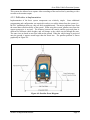
1
NARROWS OVERSIZED VEHICLE
IDENTIFICATION SYSTEM (NOVIS)
TECHNICAL MEMORANDUM 2:
TEST-BED EVALUATION OF WIDTH
DETECTORS
Prepared by
Trevor Iman, Graduate Research Assistant
and
Patrick McGowen, Research Engineer
of the
Western Transportation Institute
College of Engineering
Montana State University
Prepared for:
California Department of Transportation
Division of Research and Innovation
Sacramento, CA
and
US Department of Transportation
Research and Innovative Technology Administration
July 2005
Disclaimer
DISCLAIMER
The opinions, findings and conclusions expressed in this publication are those of the authors and
not necessarily those of the California Department of Transportation or Montana State
University.
Alternative accessible formats of this document will be provided upon request. Persons with
disabilities who need an alternative accessible format of this information, or who require some
other reasonable accommodation to participate, should contact Kate Heidkamp, Communications
and Information Systems Manager, Western Transportation Institute, Montana State University,
PO Box 174250, Bozeman, MT 59717-4250, telephone number 406-994-7018, e-mail:
[email protected].
Western Transportation Institute
Page i
Acknowledgements
ACKNOWLEDGMENTS
The authors would like to thank Caltrans staff for their assistance and support during this project;
specifically Lindsee Tanimoto, Sean Campbell, Brian Finck, Jim McClure, Royal McCarthy, and
Marty Van Zandt. Also, this project would not have been completed without the help from
various vendors, installers and system integrators. Thanks to Tommy Hardy, programmer;
Daniel Gossack, TimeMark; Andreas Hartmann, ASIM; Doug Galarus, WTI; John Shearer,
Iteris; Shel Leader, Independent Systems Integration; and Harold Smith, Smith Electric.
Western Transportation Institute
Page ii
Abstract
ABSTRACT
The Narrows Oversize Vehicle Identification System (NOVIS), funded as a part of the
California/Oregon Advanced Transportation Systems (COATS) Showcase program, seeks to
develop and deploy technologies that can mitigate challenges caused by oversize vehicles in a
narrow two-lane rural highway in northern California. This report summarizes Phase 2 of
NOVIS – the procurement, deployment, testing and evaluation of alternative technologies to
measure vehicle width and length.
US Route 199, which connects Crescent City, California and Grants Pass, Oregon, serves as a
connector between US Route 101 and Interstate 5 with a significant volume of through traffic.
The roadway is characterized by narrow lane widths, minimal or no shoulders, tight-radius
curves, a nearly vertical rock cut slope on the west edge of the road, and guardrail separating the
roadway from the Smith River Canyon to the east. The restrictions caused by these geometric
constraints render some larger trucks unable to use the roadway, creating the need for the NOVIS
system. In order to automatically detect oversize vehicles, an accurate width detection system is
needed. This report is an evaluation of those technologies used for width detection.
The five types of detection sensor technologies implemented were:
•
Piezo-Electric/Road Tubes (Timemark). For this evaluation, road tubes were used as a
surrogate for a piezo-electric installation. Road tubes are rubber tubes that are
compressed when a tire passes over them. This causes a thrust of air to be measured by
the unit on the roadside. The system was implemented in two locations due to constraints
of the test-bed installation area.
•
Video (Iteris). Video detection uses algorithms to interpret images collected in real-time
by the camera(s) to determine information such as traffic volume, vehicle presence
(including length), and vehicle speed. In this application, the system attempted to
identify over-wide vehicles using presence detection in small one-foot zones.
•
Side-fire Ultrasonic (ASIM). Side-fire ultrasonic detectors were placed on either side of a
lane to measure vehicle width. These detectors determine the distance to an object by
sending an ultrasonic pulse and marking its return echo. This was done at four different
mounting heights to aid in accurately measuring different widths that may occur
depending on the load dimensions for any particular vehicle.
•
Microwave Radar (Falcon). The Falcon is a Doppler radar system that was intended for
vehicle speed measurement. The length measurements that were needed could not be
measured and this system was removed prior to evaluation.
•
Overhead Ultrasonic (ASIM). The overhead ultrasonic system is similar to the side-fire
ultrasonic system but was intended to measure length. Interference problems between the
overhead and side-fire ultrasonic detectors led to this system being abandoned prior to the
evaluation.
Evaluations of the first three over-wide detection technologies were completed over the course of
the past two years. These evaluations were initially intended to evaluate the data from a single
site comparing technologies; however, the limitations created by each system, and the test-bed
site required that they be evaluated separately. Evaluation of each system was completed based
on three areas of interest: system consistency, accuracy, and durability. The last two detection
Western Transportation Institute
Page iii
Abstract
technologies were not fully evaluated due to system integration issues and other challenges
discussed in this report.
Piezo Electric/Road Tubes were found to be consistent; the data evaluated indicated that all
vehicles were identified by the system. To evaluate the accuracy, offset values calculated were
compared to the actual values that were taken from video data. This reveals that the system
typically underestimates the vehicle offset from edge of traveled way by less than one half foot.
The system was implemented as a proof of concept design using road tubes and thus the
durability was not expected to rival that of a permanent system using piezo-electric. This
implementation was also used to measure axle widths, and a true measure of vehicle widths may
differ particularly in over-wide vehicles.
The video image detection system was found to consistently identify all the vehicles that entered
the system, but was determined to be somewhat inaccurate in the generation of alarms for overwide vehicles due to parallax error, vehicle color, shadows causing false identification, and
detection zone sensitivity. This system was very durable, and could still be used if the accuracy
issues could be resolved.
Side-fire ultrasonic detection was plagued by durability issues, and was only operational for
limited periods of time. The available evaluation data indicates that the system can consistently
detect vehicles. Data on the accuracy of width measurement provided mixed results. The
system could not be kept on-line long enough to fully demonstrate its capabilities.
These evaluations indicate that this project is not ready to move to Phase 3 (roadside
implementation). The evaluation does provide some insight into issues with detection and some
possible methods for improving systems that could make them operational. In addition to
modifications of the current technologies that were tested, innovations and continued advances in
technology could offer some possible alternatives.
Western Transportation Institute
Page iv
Table of Contents
TABLE OF CONTENTS
List of Figures ............................................................................................................................... vii
List of Tables ............................................................................................................................... viii
1.
Introduction..............................................................................................................................1
1.1. Background / Statement of Need .................................................................................... 1
1.2. Narrows Improvements................................................................................................... 2
1.3. NOVIS Test-Bed............................................................................................................. 3
2.
Vehicle Size .............................................................................................................................7
2.1. Legal Requirements ........................................................................................................ 7
2.2. Measurements ................................................................................................................. 7
2.3. Legal Requirements for the Narrows.............................................................................. 8
2.3.1.
STAA Requirements............................................................................................... 8
2.3.2.
California Legal Truck Network............................................................................. 8
2.3.3.
Advisory Routes...................................................................................................... 9
2.4. Typical Truck Dimensions.............................................................................................. 9
2.5. Issues with Length Detection........................................................................................ 12
3.
Vehicle Detection...................................................................................................................13
4.
Over-Wide Vehicle Detection Systems .................................................................................16
4.1. Road Tubes/ Piezo-Electric Detection .......................................................................... 16
4.1.1.
System Description ............................................................................................... 17
4.1.2.
Additional Deployments ....................................................................................... 18
4.1.3.
Difficulties in Implementation.............................................................................. 20
4.1.4.
Testing................................................................................................................... 20
4.1.5.
Evaluation ............................................................................................................. 20
4.2. Video Detection Systems.............................................................................................. 22
4.2.1.
Video Detection System Description.................................................................... 22
4.2.2.
Difficulties in Implementation.............................................................................. 25
4.2.3.
Testing................................................................................................................... 27
4.2.4.
Evaluation ............................................................................................................. 27
4.3. Side-fire Active Ultrasonic System .............................................................................. 28
4.3.1.
Side-fire Ultrasonic Detection System Description.............................................. 28
4.3.2.
Difficulties in Implementation.............................................................................. 31
4.3.3.
Testing................................................................................................................... 32
4.3.4.
Evaluation ............................................................................................................. 32
4.4. ASIM Overhead Ultrasonic and Falcon Overhead Radar............................................. 34
5.
Conclusions............................................................................................................................36
Western Transportation Institute
Page v
Table of Contents
6.
Next Steps ..............................................................................................................................38
6.1. Existing ITERIS Video with Rangefinder .................................................................... 38
6.2. Existing ITERIS Video with Second Camera at Different Height ............................... 38
6.3. Blade Detector .............................................................................................................. 40
6.4. AutoSense Laser Rangefinder....................................................................................... 42
7.
Appendix................................................................................................................................46
7.1. Road Tube Specifications ............................................................................................. 46
7.2. Video Camera Specifications........................................................................................ 49
7.3. Vantage One Video Processor Specifications............................................................... 49
7.4. PLC (for video system) Specifications ......................................................................... 50
7.5. DT272 Ultrasonic/Infrared sensors............................................................................... 51
7.6. Falcon Radar Specifications ......................................................................................... 52
8.
References..............................................................................................................................53
Western Transportation Institute
Page vi
List of Tables
LIST OF FIGURES
Figure 1-1: Project Location Map................................................................................................... 2
Figure 1-2: CMS Installation During Phase One............................................................................ 3
Figure 1-3: Test-Bed Entrance at Maintenance Yard ..................................................................... 4
Figure 1-4: Front and Back of Controller ....................................................................................... 5
Figure 2-1: King Pin to Rear Axle Length...................................................................................... 7
Figure 2-2: Highway Designation for Del Norte County ............................................................... 8
Figure 4-1: Road Tube Layout “Z” Configuration ....................................................................... 17
Figure 4-2: Road Tube Layout “X” Configuration....................................................................... 18
Figure 4-3: I-90 Camera Deployment........................................................................................... 19
Figure 4-4: I-90 Road Tube Layout and Width Markers.............................................................. 19
Figure 4-5: Actual Width Deviations............................................................................................ 21
Figure 4-6: Overhead Video Detection Configuration ................................................................. 22
Figure 4-7: Video Detection System Components ....................................................................... 23
Figure 4-8: ITERIS Detection Zone Layout ................................................................................. 24
Figure 4-9: Parallax Error Diagram .............................................................................................. 25
Figure 4-10: Iteris Measure of Accuracy ...................................................................................... 27
Figure 4-11: PIR/Ultrasonic Detector Deployment Configuration............................................... 29
Figure 4-12: DT272 Sensor Head ................................................................................................. 30
Figure 4-13: IF 485 ....................................................................................................................... 30
Figure 4-14: Expected ASIM Layout ........................................................................................... 31
Figure 4-15: Falcon Radar ............................................................................................................ 34
Figure 6-1: Beam Configuration for Autosense............................................................................ 39
Figure 6-2: Blade Detector Temporary Installation and Inductance Signature ............................ 41
Figure 6-3: Beam Configuration for Autosense............................................................................ 42
Figure 6-4: Vehicle Profiles for Autosense 625 ........................................................................... 44
Figure 6-5: WTI Mobile Lab ........................................................................................................ 45
Western Transportation Institute
Page vii
List of Figures
LIST OF TABLES
Table 2-1: Distribution of Truck Lengths in CA .......................................................................... 10
Table 2-2: Trucks and Miles by Vehicle Width for CA ............................................................... 11
Table 2-3: Trucks by Length and Width (excludes blank responses)........................................... 11
Table 2-4: Trucks by Trailer Type and Width (excludes blank responses).................................. 12
Table 3-1: Classification of Vehicle Detection Technologies ...................................................... 13
Table 3-2: Typical Errors with Detectors ..................................................................................... 15
Table 4-1: Parallax Error .............................................................................................................. 26
Table 4-2: Percent Trucks Blocked by Opposing Vehicle............................................................ 32
Table 4-3: Passenger Car Results for Ultrasonic .......................................................................... 33
Table 4-4: ASIM Measured Widths.............................................................................................. 34
Table 6-1: Erroneous Width Measurements ................................................................................. 40
Table 6-2: Worst Case Error for Measured Widths ...................................................................... 43
Western Transportation Institute
Page viii
Introduction
1. INTRODUCTION
The Narrows Oversize Vehicle Identification System (NOVIS), funded as a part of the
California/Oregon Advanced Transportation Systems (COATS) Showcase program, seeks to
develop and deploy technologies that can mitigate challenges caused by oversize vehicles in a
narrow two-lane rural highway in northern California. The project consists of a three-phase
approach:
•
•
the deployment of changeable message signs with static messages (Phase 1);
the procurement, deployment, testing and evaluation of alternative technologies to
measure vehicle width and length (Phase 2); and
•
the design, installation and evaluation of a full-scale integrated detection and warning
system related to oversize vehicles (Phase 3).
The phased approach is designed to ensure that the final deployed system is an integrated system
that provides accurate and useful information to the traveling public. However, this integrated
system will not occur automatically; it requires a thorough systems engineering approach at all
stages of the process.
This document is a summary of Phase 2 activities, an evaluation of the technology options
implemented at a test bed location in Eureka, California. This paper provides an overview of
issues regarding vehicle size, a review of the technologies selected and difficulties involved with
accuracy, development and implementation of these technologies. The document uses data
collected from several technologies to evaluate their effectiveness, and mainstream
implementation implications.
1.1.
Background / Statement of Need
US Route 199, which runs between Crescent City, California and Grants Pass, Oregon, serves as
a connector between US Route 101 and Interstate 5 (see Figure 1-1) with a significant volume of
through traffic. The roadway is characterized by narrow lane widths, minimal or no shoulders,
tight-radius curves, a nearly vertical rock cut slope on the west edge of the road, and guardrail
separating the roadway from the Smith River Canyon to the east.
One particular area where these characteristics are focused occurs between post miles 22.39 and
23.16 on US Route 199, at a section called “The Narrows”. In the Narrows, the absence of
shoulders combines with substandard lane widths and dramatic turns to create difficulties when
vehicles meet each other. Trucks with long or wide loads are unable to negotiate the road if a
vehicle is coming from the other direction at the same time. However, visibility constraints due
to vertical rock faces on the inside of curves prevent drivers from knowing of these dangers in
advance. Some larger trucks are unable to pass through at all, due to the inability to maneuver
through the exceptionally narrow geometry.
California Department of Transportation (Caltrans) District 1, where the Narrows is located,
conducted a review of accident statistics for the location. Their review found that the rate of
accidents per million vehicle miles of travel was approximately six times higher on the Narrows
than on comparable facilities, and for injury accidents was about four times higher. It is
speculated that the number of collisions for the Narrows corridor may be underestimated. Due to
Western Transportation Institute
Page 1
Introduction
the absence of shoulders, drivers may have a minor collision and not bother to report it because
of the inability to pull over and review damage or exchange information with the other driver.
(Source: http://www.mapquest.com)
Figure 1-1: Project Location Map
The COATS project identified the need for a system to provide an “Advance Warning System
for Narrow Lane Widths” due to the narrow mountainous roadways in rural areas that are
frequently traveled by commercial vehicles. The functions of this system were described as
follows (1):
“The system would identify the vehicle type and speed through weigh-in-motion,
and provide upstream warning to other travelers through a flashing beacon.”
This concept is called the Narrows Oversize Vehicle Identification System (NOVIS). The key to
this project is the ability to detect oversize vehicles. Identifying methods for the accurate
detection of oversized vehicles is the primary purpose of this phase of the project.
1.2.
Narrows Improvements
Caltrans has made several efforts to reduce the number of incidents occurring on this roadway
section including centerline rumble strips, rock removal, and – as part of the NOVIS project –
changeable message signs (CMS). A brief description of these improvements is provided here.
Western Transportation Institute
Page 2
Introduction
The centerline rumble strips are depressions made in the pavement along the centerline. The
result of these depressions is a rumbling noise when a vehicle’s tire rides over them. Therefore,
if a driver crosses the centerline, the rumbling noise will alert him/her to that fact.
Caltrans removed rocks from the vertical cut slopes in an effort to increase visibility. Removing
the rocks did not change the alignment, but did increase sight distance.
Two CMS were installed, shown in Figure 1-2, that read “CAUTION ROAD NARROWS
AHEAD” to provide static warnings to motorists about the narrow widths in this area and
therefore to increase driver awareness of the potential for vehicle conflicts. Evaluation of these
signs in summarized in the NOVIS Phase 1 report (2).
(Northbound)
(Southbound)
Figure 1-2: CMS Installation During Phase One
1.3.
NOVIS Test-Bed
In order to have a controlled environment to test the various width detectors, a test-bed was
constructed at the Caltrans maintenance yard in Eureka, CA. This yard is the property of
Caltrans and was chosen based on
•
•
•
•
•
the knowledge of vehicles entering the yard;
the presence of some large truck traffic;
the location being safer than a roadside setting;
the availability of specific amenities such as on-site personnel, power, and
communications; and
protection against vandalism and theft as the location is fenced and secured.
Western Transportation Institute
Page 3
Introduction
Figure 1-3 shows the entrance to the maintenance yard where the width detectors were placed.
For the test-bed, two poles were installed at the entrance with appropriate conduit and wiring. A
functioning Road Weather Information System (RWIS) and Closed Circuit Television (CCTV)
were installed on the top of the right pole. The RWIS and CCTV are Caltrans equipment, not
directly part of this project. They will remain after the test-bed is removed. The left pole
includes a mast arm for overhead instruments at a height of 30 feet. In this picture only the video
camera for the video detection system is installed on the mast arm. The overhead ultrasonic was
also installed on the mast arm but removed for reasons discussed later in this report. Each pole
has the required mounting for four side-fire ultrasonic detectors. Buried conduit for power and
communications runs from each of these poles to the control cabinet located inside a
maintenance shed to the left of the entering view in Figure 1-3.
Entering
Exiting
Figure 1-3: Test-Bed Entrance at Maintenance Yard
Caltrans District 1 allowed space for the NOVIS project equipment in one of their controller
cabinets on site. The cabinet is shown in Figure 1-4. On the top of the cabinet, you can see the
monitor for the NOVIS computer. On the top shelf are the video monitor, Iteris controller, and
programmable logic controller (PLC) for the video detection system. The NOVIS computer is
located on the next shelf down. The remainder is equipment not related to NOVIS with the
exception of a cable router on the bottom shelf. Equipment related to specific width detection
systems will be described later in this report. Equipment that is part of the testbed “backbone”
and common to all systems is discussed here.
Western Transportation Institute
Page 4
Introduction
Front
Back
Figure 1-4: Front and Back of Controller
The computer is a standard Pentium running on the Microsoft Windows operating system. The
computer is not required in order for the various detection systems to operate; it was used to
monitor and collect data on the systems. The computer was equipped with extra data ports to
accommodate the numerous systems. In order to facilitate remote access for monitoring and
downloading data, the following items were added:
•
•
•
a Cisco 831 router,
Black Ice PC Protection software from Internet Security Systems, and
PC-Anywhere version 10.5 produced by Symantec.
Although this was a good location for the test-bed for the attributes listed previously, there were
characteristics that caused problems with some of the detection systems. These problems are
listed here, but discussed in more depth in the sections of the report relating to the specific
detection devices where these issues were a problem.
•
Due to the number of detection systems, there was some interference between
communications and detection signals. This problem was resolved after the overhead
ASIM detector was removed.
Western Transportation Institute
Page 5
Introduction
•
Vehicles were not well channelized. There is two-way traffic on essentially a 23-foot
width. However, there is no lane striping. Vehicles generally exit on their right side, but
those entering usually drive down the middle.
•
Many vehicles entered the detection zone at an angle. They either were not completely
straight upon entering the lot, or were turning to park near the entrance.
•
Speeds were generally very slow (under 15 mph). This caused echoes to be recorded in
the road tube data.
•
The gate to the maintenance yard was locked, typically from 6 pm to 6 am. This was
beneficial from a vandalism standpoint but did not allow for testing of detection systems
in nighttime conditions.
Western Transportation Institute
Page 6
Vehicle Size
2. VEHICLE SIZE
This section provides an overview of typical vehicle dimensions, legal requirements, and issues
with detection relating to truck dimensions.
2.1.
Legal Requirements
Although the initial purpose of the NOVIS system is not to determine the legality of trucks
traveling on this facility, it provides a guideline to identify which vehicles are “oversized”.
National standards for vehicle dimensions allowed on highways are detailed by the Surface
Transportation Assistance Act (STAA) of 1982. Each state is afforded the right to change the
legal definition of standards for roads that do not receive federal assistance. The following
sections outline the requirements for trucks as specified by Section 15 of the California Vehicle
Code (CVC) (3), which include STAA and California Legal trucks.
2.2.
Measurements
The basis for measurements in California is as follows. Kingpin to rear axle (KPRA) length is
measured from the center of the king pin to the center of the rearmost axle (Figure 2-1). KPRA
length is more important than total vehicle length (i.e., bumper to bumper) because it determines
the amount of off-tracking when the vehicle rounds a curve. Width is defined as the total outside
width of the vehicle or its load. Height is measured from the surface on which the vehicle stands
to the top of the load/vehicle.
Figure 2-1: King Pin to Rear Axle Length
Western Transportation Institute
Page 7
Vehicle Size
2.3.
Legal Requirements for the Narrows
As shown in Figure 2-2, the Narrows on US Route 199 is an Advisory Route. This indicates that
trucks wishing to use this facility are restricted by STAA, California requirements and additional
advisories. The advisory for this route is for vehicles with KPRA lengths of 30 feet.
(Source: 4)
Figure 2-2: Highway Designation for Del Norte County
2.3.1. STAA Requirements
The Surface Transportation Assistance Act (STAA) requires states to allow larger trucks on the
“National Network,” which is comprised of the Interstate system plus the non- Interstate Federalaid Primary System. The STAA requirements are listed below as a reference so the change in
requirements can be quantified.
STAA Truck Tractor - Semi Trailer
Semi trailer length
KPRA
Overall length
: 48 feet maximum
: no limit
: no limit
Semi trailer length
KPRA
: over 48 feet up to 53 feet maximum
: 40 feet for two axle,
: 38 feet for single axle trailers
: no limit
Overall length
STAA Truck Tractor – Semi Trailer - Trailer (Doubles)
Trailer length
Overall length
: 28 feet 6 inches maximum (each trailer)
: no limit
2.3.2. California Legal Truck Network
These requirements are in addition to the STAA requirements. The requirements for California
legal trucks are extensive. However, the basic requirements that we are interested in are:
Western Transportation Institute
Page 8
Vehicle Size
Length:
California Legal Truck Tractor –Semi trailer
Semi trailer length
KPRA
Overall length
: no limit
: 40 feet for two axle
: 38 feet for single axle trailer
: 65 feet maximum
California Legal Truck Tractor – Semi trailer-Trailer (Doubles)
Option A
Trailer Length
Overall length
KPRA
: 28 feet 6 inches maximum (each trailer)
: 75 feet maximum
: No Limit
Option B
Trailer length
KPRA
Overall length
: One trailer 28 feet 6 inches maximum
Other trailer may be longer than 28 feet 6 inches
: No limit
: 65 feet maximum
Width:
Total outside width of any vehicle or its load
May be limited (by any jurisdiction)
: 102 in
: 96 in (must be posted)
Height:
Total height (measured from surface upon which vehicle stands)
: 14 feet
2.3.3. Advisory Routes
Advisory routes are those that restrict the KPRA length. Travel is not advised
if KPRA length is over posted value. Advisory lengths are a guideline that
should be followed by all trucks; however, California legal limits still apply.
These advisories are put in place due to the roadway geometry and the
reduced turning radius of the highways in any particular area. Advisories
range from 30 to 38 feet. The KPRA Advisory for this facility is 30 feet as defined by the
California Department of Transportation.
2.4.
Typical Truck Dimensions
Typical truck dimensions are difficult to determine due to the number of different manufacturers,
vehicle age, and changes in technology. Trailer dimensions are, however, to some degree, more
easily determined. Typical trailer widths are separated into two categories: 96 in, and 102 in
widths. These are the legal widths allowed on most roadways, including those in California
(unless restricted by a specific jurisdiction and posted). Some of the challenges discussed later in
this document relate to specific vehicle types. This section attempts to quantify the types and
quantities of vehicle on the roadway.
Western Transportation Institute
Page 9
Vehicle Size
Some idea of the number of different sized vehicles can be determined by the 2002 Vehicle
Inventory and Use Survey conducted by the US Census Bureau. This is an annual survey sent to
registered commercial vehicles owners. It is an extensive national survey with a good
representative sample. Table 2-1 shows the breakdown of California-owned commercial
vehicles by length.
Table 2-1: Distribution of Truck Lengths in CA
Truck Length (ft)
Total Trucks (thousands)
Total Truck Miles (millions)
Less than 20
20 to 27.9
28 to 35.9
173.5
129.3
59.2
2,351.2
1,899.3
1,073.6
36 to 40.9
41 to 44.9
45 to 49.9
50 to 54.9
55 to 59.9
60 to 64.9
23.0
8.7
10.9
9.7
15.5
34.7
408.1
206.2
500.8
416.3
591.5
1,806.7
65 to 69.9
70 to 74.9
75 to 79.9
80 or more
19.7
1,063.0
8.9
614.2
3.6
292.7
too much variability to estimate
(Source: 5)
The data in Table 2-1 comes from the summary report for California, which has been adjusted
for stratification of sample, variance, and other statistical adjustments. It excluded pick-up
trucks, mini-vans, and sport-utility vehicles, but did include single-unit trucks.
Information on the distribution of vehicle widths would also be helpful. However, this was not in
the summary report for California, but is available from the raw data. Table 2-2, Table 2-3, and
Table 2-4 report on the proportion of respondents from the raw data. Unlike the results in Table
2-1, they do not have the same statistical adjustments and do not include single unit trucks (only
tractor trailers).
Table 2-2 shows the breakdown by vehicle width for California. It is difficult to determine what
proportion of vehicle sizes will be on any given roadway. We would assume larger trucks would
be less likely to travel on mountainous two-lane roads for which the NOVIS would be
implemented. However, from these results we could expect to see around 30 percent of tractortrailers detected as “over-wide” if we use the criteria of greater width than eight feet.
Western Transportation Institute
Page 10
Vehicle Size
Table 2-2: Trucks and Miles by Vehicle Width for CA
Width
Total
8 ft
8.5 ft
Other
Blank
% by vehicle
48%
32%
1%
20%
% by VMT
46%
37%
0%
16%
Table 2-3 shows this same breakdown by length. Notice that many vehicles that would pass the
width limit of eight feet or less, but would be much larger than the length advisory. Remember
KPRA length advisory for the Narrows is 30 feet. The lengths in Table 2-3 are total vehicle
lengths and are slightly larger than the KPRA length by 16 to 27 feet based on the typical
dimensions in the AASHTO Green Book (8).
Table 2-3: Trucks by Length and Width (excludes blank responses)
Length
8 ft
Width
8.5 ft%
Less than 20
20 to 27.9
28 to 35.9
36 to 40.9
41 to 44.9
45 to 49.9
50 to 54.9
55 to 59.9
60 to 64.9
65 to 69.9
70 to 74.9
75 to 79.9
80 or more
0.0%
0.0%
0.5%
2.7%
2.0%
6.4%
5.5%
8.2%
16.4%
11.8%
4.2%
1.5%
0.2%
0.0%
0.0%
0.0%
1.6%
1.6%
1.3%
0.9%
4.0%
15.1%
8.0%
4.4%
2.7%
0.2%
Western Transportation Institute
Other
0.0%
0.0%
0.0%
0.0%
0.0%
0.0%
0.2%
0.0%
0.2%
0.2%
0.0%
0.0%
0.2%
Page 11
Vehicle Size
Many of the systems for measuring vehicle width discussed in this report assume a square
vehicle. Note the significant proportion of liquid tankers, which are typically rounded, in Table
2-4. Also, consider the large number of flatbed trucks that will be carrying a variety of loads
with many different sizes and shapes.
Table 2-4: Trucks by Trailer Type and Width (excludes blank responses)
Trailer Type
Auto Carrier
Beverage
Curtainside
Dump
Flatbed, Platform
Livestock
Lowboy
Mobile home toter
Open Top
Pole, Logging, Pipe
Tank, Dry
Tank, Liquid
Equip. Trailer Mounted
Van, basic enclosed
Van, Drop Frame
Van, Insul.
Van, Insul., Refridge.
2.5.
8 ft
Width
8.5 ft%
Other
0.2%
1.8%
0.0%
9.8%
16.2%
0.2%
1.3%
0.0%
2.0%
0.5%
2.7%
4.9%
0.0%
16.4%
0.4%
0.2%
2.7%
1.1%
0.2%
0.2%
3.6%
4.9%
0.0%
1.6%
0.0%
0.7%
0.0%
0.7%
0.0%
0.0%
20.6%
0.4%
0.2%
5.6%
0.0%
0.0%
0.0%
0.2%
0.0%
0.0%
0.0%
0.2%
0.0%
0.0%
0.0%
0.0%
0.0%
0.4%
0.0%
0.0%
0.0%
Issues with Length Detection
In addition to the difficulty of measuring loads, measuring KPRA length automatically at
mainline speeds is almost impossible. Detecting the location of the axles and even the bumpers
are most likely possible, but the location of the kingpin would be very difficult to determine.
The kingpin is typically located over the rear axle of the tractor. The distance from the front
bumper to the rear axle of the tractor ranges from 13.33 ft to 23.5 ft for the typical tractors listed
in the AASHTO Green Book (8). However, using the location of the rear axle of the tractor as
the location of the kingpin is not exact either. Most tractors have a sliding fifth wheel plate that
allows them to change the load properties of the axles. This is achieved by moving the fifth
wheel plate forward or backward on a set of rails connected to the tractor. Although this is an
excellent means of changing axle load factors, it creates problems with measurement of KPRA
lengths.
For this reason we did not pursue length measurement, but focused on width. Specifically can
we discern between vehicles with a width of 96 inches or less and vehicles 102 inches or wider.
Western Transportation Institute
Page 12
Vehicle Detection
3. VEHICLE DETECTION
Traffic data collection is essential to many aspects of transportation engineering. The methods to
collect that data have increased and become more complex in recent years. There are many
types of equipment available for collecting traffic data, and most of them are used to collect
volume, speed, vehicle class, vehicle weight, and other parameters. Before getting into specific
technologies for width detection, this section provides a background on automated vehicle
detectors and defines some general terms.
The methods used to collect traffic data can be grouped into two basic categories; intrusive
devices and non-intrusive devices. Intrusive devices are those devices that require the placement
of sensors either in or on the travel lane being investigated. The non-intrusive devices are those
that do not interfere with traffic flow.
With this classification, the sensor technologies are listed in Table 3-1.
Table 3-1: Classification of Vehicle Detection Technologies
Intrusive Devices
Non-Intrusive Devices
•
•
•
•
•
•
•
•
•
Pneumatic Road Tube
Piezo-Electric Sensor
Inductive Loop
Passive Magnetic
Video Image Detection
Passive Acoustic
Passive and Active Infrared
Microwave/Radar
Ultrasonic
The detection technologies outlined above each use different sensors to collect data. In order to
evaluate or use these sensor technologies a basic understanding of their properties is necessary.
•
Pneumatic Road Tubes are rubber tubes that are compressed when a tire passes over
them. This causes a thrust of air to be measured by the unit on the roadside.
•
Piezo-Electric is a specially processed material capable of converting kinetic energy to
electrical energy. When a vehicle passes over a detector, the piezo-electric material
generates a voltage proportionate to the force or weight of the vehicle. The material only
generates a voltage when the forces are changing. The initial charge will decay if the
force remains constant.
•
Inductive Loops consist of: a detector oscillator that serves as a source of energy for the
detector, a lead-in cable, and one or more turns of insulated loop wire in a shallow slot
sawed in or across the pavement. When a vehicle passes over a loop or stays in a loop
area, loop inductance is reduced and oscillator frequency is increased. A vehicle’s
presence is determined when frequency change exceeds the threshold set by the
sensitivity setting.
•
Passive Magnetic detectors measure the change in the earth’s magnetic field. They
require a warm-up time, preferably in low traffic volumes, to calibrate to the baseline
magnetic field. Speed can be measured by analyzing the slope of the magnetic signature
at several locations.
Western Transportation Institute
Page 13
Vehicle Detection
•
Video Image Detection (VID) use changes in pixel colors in camera images to identify
vehicles. Speeds can be measured by setting up a simulated dual loop by having two
detection zones in the field of view.
•
Passive Acoustic detectors measure the sound waves from vehicles. Speed can be
determined by the change in frequency as the vehicle passes the sensor.
•
Passive Infrared utilizes infrared imaging to measure heat differentials of a particular
area. When a vehicle passes a point in the roadway, its heat is sensed and detected.
Much like video image detection, speed can be determined by how fast this change in
heat moves across several pixels.
•
Active Infrared detectors send an infrared laser and measure the time it takes for the
beam to return. If a vehicle is present, the time for the beam to return will be less than
that of the background roadway.
•
Microwave Radar detectors utilize radio waves (usually microwave or laser) to make
use of the Doppler effect.
•
Ultrasonic detectors, similar to active infrared, send out ultrasonic pulses and measure
the time for those pulses to return to the sensor.
The non-intrusive technologies are fairly unique in that some of them may be mounted in two
different configurations. These are the overhead and side-fire configurations. Overhead
mounting requires the placement of the sensor technology over the center of the detection area.
Side-fire mounting utilizes a pole (preferably an existing one) that places the sensor high on the
edge of the roadway. By mounting the devices at different locations the properties measured by
them may change, or be detected in a more efficient manner.
Many detector types may claim to be able to measure vehicle length; however, very few studies
have been completed to determine the accuracy of these vehicle lengths. Measured vehicle
length can refer to spacing, effective vehicle length and total vehicle length.
•
Spacing is the distance between axles. Road tubes and Piezo-electric sensors measure the
spacing.
•
Some detectors measure a field the vehicle creates (e.g., magnetic field) and the actual
vehicle. The length of this field is effective vehicle length. Inductive loops, passive
magnetic, passive acoustic, and passive infrared typically measure “effective vehicle
length.” Effective vehicle length is certainly correlated to vehicle length, but typically
has some biased error.
•
Total vehicle length is the length of the vehicle from the front bumper to the back
bumper. Depending on the configuration, video, radar, ultrasonic, and active infrared can
measure total vehicle length (i.e., bumper to bumper), but can also measure effective
vehicle length.
Length determination is typically based on the speed that is also measured by the system. If the
speed is in error, the length will also be in error.
Most of the detectors in their typical configurations are incapable of detecting widths. Video
image detection, passive infrared, active infrared, and ultrasonic detectors can measure width.
Western Transportation Institute
Page 14
Vehicle Detection
However, this is not typically included in the programming of most commercially available
sensors.
Each type of detection is subject to error in vehicle counts and speeds. The evaluation of the
error incurred by different devices varies depending on the location, setup, and method of error
calculation. Table 3-2 provides a basic range of each technologies error depending on the
detection information being collected. Typically, these errors are based on the total count and
average speed for a fifteen-minute interval. The errors for detecting specific vehicles might be
much higher. For example, in one fifteen-minute interval a road tube may miss 30 vehicles, but
if it has 30 false detections, the count will be exact. Also, a detector may only find valid speed
values for half the vehicles, but this average will likely be close to the average for all the
vehicles.
Table 3-2: Typical Errors with Detectors
Error Rates
Vehicle Count
Speed
Intrusive Devices
Pneumatic Road Tube
0.92 to 30%
NA
Piezo-Electric Sensor
NA
NA
2 to 3%
1.2 to 10%
0.7 to 2.4%
5.80%
Passive Infrared
1 to 10%
10.80%
Passive Magnetic
1.2 to 5%
1.4 to 4.8%
Microwave/Radar
2 to 13.8%
1 to 7.9%
Ultrasonic
1.2 to 2%
NA
Passive Acoustic
4 to 16%
3.4 to 6.3%
1.6 to 15%
0.8 to 8%
Inductive Loop
Non-Intrusive Devices
Active Infrared
Video Image Detection
(Source: )
It can be seen that even in the simplest detection scheme, counting vehicles, all of the detection
technologies have some error. Detection technologies for vehicle counts and speeds have had
more widespread use than those specifically designed for measuring individual vehicle
dimensions (i.e., height, width, or length). Also, measuring a vehicle dimension is more difficult
than just detecting its presence for vehicle counts. For these reasons, errors when attempting to
detect individual vehicle dimensions may be worse than those shown in Table 3-2.
Western Transportation Institute
Page 15
Over-Wide Vehicle Detection Systems
4. OVER-WIDE VEHICLE DETECTION SYSTEMS
Identifying over-wide vehicles offers a number of challenges, the main challenge being that this
is not a measurement/function currently performed for traffic monitoring. Consequently,
systems selected to perform this role were systems originally designed to make other
measurements that have been modified for this application. Modification mainly entailed
redesign of software programs that process data collected by sensors and specialized mounting
configurations for sensors. A general description of the metrics and approach that were used to
evaluate the various detectors was required for vendors to develop cost estimates, and have been
included below as a reference.
Test Metrics
The technology overview prepared by SAIC (7) stated:
“Sensor effectiveness will not be evaluated against a benchmark (e.g., 95 percent
of all vehicles within 10 percent of actual width at widest point of the vehicle) but
will instead be evaluated vis a vis other technologies in the test. WTI will be able
to determine minimum acceptable standards for measurement accuracy based on
the data generated during the testing process. The main evaluation factors will be
(in order of importance) accuracy of measurement, percent of vehicles for which a
measurement is obtained, and system reliability.”
None of the systems worked well enough within the test-bed to allow for appropriate comparison
by the method mentioned above. As such, for each system, test metrics depended on available
data and setting.
This section describes the systems that were evaluated at the test-bed location with regard to
their ability to detect over-wide vehicles. The five types of detection sensor technologies
implemented for the NOVIS system are:
•
•
•
•
•
Piezo Electric/Road Tubes (Timemark)
Video (Iteris)
Side-fire Ultrasonic (ASIM)
Microwave Radar (Falcon)
Overhead Ultrasonic (ASIM)
The following sections outline the equipment used, the difficulties experienced while
implementing these systems, how they were evaluated, and a system evaluation.
4.1.
Road Tubes/ Piezo-Electric Detection
Piezo-electric systems convert mechanical input – in the form of pressure or strain induced on
semi-crystalline piezo-electric polymer material – into an electrical charge. Vehicles driving
over piezo-electric sensors compress the sensors, creating the strain necessary to generate
electrical output that is transmitted to processing hardware. The concept for this approach is a
two-stage process. The first stage is a proof of concept test and the second stage is “permanent”
system deployment. Due to the high cost of installing piezo-electric sensors, including cutting
the pavement, our approach was to use inexpensive road tubes as a surrogate during the proof of
concept phase. Assuming that a sufficiently high correlation can be established for application to
Western Transportation Institute
Page 16
Over-Wide Vehicle Detection Systems
the NOVIS project, piezo-electric sensors may be introduced for use in detecting over-wide
vehicles.
4.1.1. System Description
The equipment used at the test-bed is the Delta IIIL, a raw data classifier, using up to four
portable road tubes. The unit is designed to collect time-tagged sensor events and store them on
a removable PCMCIA flash memory card. The unit uses a 6V battery with capacity to allow 60
days of continuous operation without recharging. The unit is housed in weatherproof housing
that can be secured to a post or tree with chain. The sensors are rubber road tubes that are
secured to the road with clamps, nails, and asphalt tape.
The time-tagged event data is downloaded to a PC with a serial cable. Prior to development of
additional software by Timemark, Inc., the data could be analyzed to provide vehicle information
including the time the vehicle was recorded, direction, speed, number of axles, axle spacing, and
gap. Width analysis was added to the classifier through the development of the Timemark
software, and the development of new road tube layouts. The initial road tube layout proposed
was in a “Z” configuration as shown in Figure 4-1.
Figure 4-1: Road Tube Layout “Z” Configuration
The use of a 30-degree angle was expected to minimize the discrepancy for dual tires and avoid
simultaneous hits by tandem axles of most trucks and trailers. Manufacturer analysis indicated
that this angle would provide widths at the tires within a maximum error of 2.9 inches at 60 mph
assuming a fixed tire width. Any speeds slower than 60 mph will result in higher accuracy.
Following more detailed analysis and testing, the development of a more accurate and reliable
“X” layout shown in Figure 4-2 was recommended and implemented.
Western Transportation Institute
Page 17
Over-Wide Vehicle Detection Systems
Figure 4-2: Road Tube Layout “X” Configuration
The X layout is intended to be a square of width and length w. Based on the known geometry of
this layout and the raw data information from all four tubes the vehicle width v can be calculated.
This layout requires vehicles to travel straight across the tube layout in order to be calculated
correctly.
4.1.2. Additional Deployments
An initial deployment was completed by the vendor for purposes of calibration and verification.
Based on the data provided from that deployment, it was seen that the system could measure axle
widths. The vendor did not provide any measure of accuracy with this data, however, and
further deployments were necessary to obtain a measure for accuracy.
The initial deployment by the evaluation team was located at the test bed in Eureka, CA. During
initial data collection, geometry and speed constraints became evident. The low speeds at the
test bed caused echoes in the road tube data, and vehicles often entered the test bed at an angle,
rendering the data useless for width detection purposes.
Due to the constraints at the test-bed location, the deployment of this system was relocated to a
more appropriate test location on Interstate 90 (I-90) westbound at milepost 319.4 on the
Bozeman Pass in Montana. This section of roadway is a straight and level section providing the
optimal situation for vehicle entering the test area. I-90 is a two lane rural interstate with an
average annual daily traffic (ADT) of approximately 12,800 vehicles, and a posted speed limit of
75 mph (6). Road tube setup was completed between October 5, 2004 and October 7, 2004.
Without a known vehicle fleet being used to test the system, width validation as a measure of
accuracy was completed using video data. Video camera trailers were set up at the test location
to record during the testing. The video was later used to obtain vehicle widths and subsequently
measure road tube accuracy. This camera deployment is shown in Figure 4-3.
Western Transportation Institute
Page 18
Over-Wide Vehicle Detection Systems
Figure 4-3: I-90 Camera Deployment
The road tubes were deployed in the same location and can be seen in Figure 4-4 as line crossing
perpendicular to the direction of travel in the shoulder lane. Width markers on the roadway were
used during video evaluation to determine vehicle offsets from the edge of traveled way and
centerline. These can be seen along the left road tube in Figure 4-4.
Figure 4-4: I-90 Road Tube Layout and Width Markers
Western Transportation Institute
Page 19
Over-Wide Vehicle Detection Systems
4.1.3. Difficulties in Implementation
Initial implementation of this system was delayed due to development of software to evaluate the
results from the data recorders. Problems also arose at the test bed due to vehicles traveling over
the road tubes at an angle as opposed to a straight entry into the maintenance yard. Slow speeds
cause errors with road tube data in the form of feedback or phantom data. This data is then
useless until it is “cleaned” or the feedback in the detection can be removed.
Implementation on I-90 encountered other difficulties related to road tubes. Implementation on a
two-lane single direction of travel interstate encounters problems with vehicles changing lanes,
and only one set of tires being in the detection zone. Additional problems were encountered due
to high speeds, and volumes. These cause road tubes to deteriorate quickly, particularly those
tubes installed at an angle. Cuts in the tubes, and pinched fasteners effectively remove that tube
from the setup and render it useless until repaired.
This system was designed to measure axle widths of vehicles, for an on-line application. In that
sense, the system generally does a good job of measuring axle widths. However, since the
application does not take into account what could possibly be located above those axles (i.e., the
actual width of the trailer), the technology may be limited.
4.1.4. Testing
Initial tests were completed by the Timemark Corporation to calibrate and validate the width
algorithms. Test data from their testing was provided to the Western Transportation Institute as a
proof of concept. Formal testing of the deployed system occurred October 7-11, 2004. Due to
the large amount of data and correlation methods being used, the data being evaluated is that
from October 8, 2004 between 1:36 PM and 2:35 PM. Data was collected in two forms during
testing: video data, and road tube data from an X layout of road tubes in the shoulder lane of
travel on I-90. Road tube setup on I-90 was concluded using a width of 12 feet, the lane width
on this section of interstate. Data was reduced and correlated from each video data set to provide
a “known” width to evaluate the Timemark system more effectively.
4.1.5. Evaluation
Evaluation of this system was completed based on three areas of interest: system consistency,
accuracy, and durability. All data was reduced and correlated between the video data and the
raw data from the road tubes. This was completed for 346 individual vehicles. Based on this
data and the Timemark VIAS data, a system evaluation was completed.
System consistency in this case is a record of how many vehicles are recognized. The raw data
correlation with video data indicates that the system is very consistent. In fact the system did not
miss one vehicle entirely. However, it does have a tendency to miss individual axle hits on one
of the four tubes per axle. This is not unexpected, and if the system had identified every single
axle on every tube, it would be an anomaly among traffic detection technologies currently in use.
Because of these missed tubes, reasonable offsets could only be calculated for 252 of the 346
vehicles (73 percent) on the I-90 test. For the vendor test 173 of 187 vehicles (93 percent) had a
reasonable calculated width. The average speed for the vendor test was 40 mph, which may
account for the higher percent than the Bozeman test.
Western Transportation Institute
Page 20
Over-Wide Vehicle Detection Systems
The accuracy of the vendor test could not be validated. However, the data does show some
concerns. Two-axle vehicle widths ranged from 4.3 feet to 6.2 feet, which seem slightly small
considering a typical passenger car is 6 to 7 feet wide and some of these two axle vehicles were
likely larger single unit trucks. For vehicles with three to seven axles, the Timemark software
calculated widths ranging from 5.5 feet to 6.4 feet. These also are too low, considering some are
tractor-trailers, which should be 8 feet wide.
Width Deviations
>3
2.75 to 3
2.25 to 2.5
1.25 to 1.5
0.75 to 1
0.5 to 0.75
0.25 to 0.5
0 to 0.25
0 to -0.25
-0.25 to -0.5
-0.5 to -0.75
-0.75 to -1
-1 to -1.25
-1.5 to -1.75
-2.5 to -2.75
35%
30%
25%
20%
15%
10%
5%
0%
< -3
% of Measured Vehicles
For the I-90 site, researchers compared the width and offset calculations from the Timemark
VIAS software, the raw road tube data, and widths measured from video. The offset refers to the
distance from the edge of the traveled way (i.e., white stripe) to the edge of the nearest tire,
which is used to calculate the width. Due to data errors, widths could not be determined from the
VIAS software, or the raw data. In place of widths, offsets were used for evaluating accuracy
instead. This correlation provides a measure of accuracy for the system based on the data
available. In this case, for the vehicles that were identified, a distribution of the actual difference
between measured distances from edge of traveled way (based on video data) and the width
extracted from the Timemark data is presented in Figure 4-5.
Deviation Category (ft)
Figure 4-5: Actual Width Deviations
This distribution shows the 252 vehicles of the 346 vehicles that could be measured. It can be
seen from this distribution that the majority of vehicles measured are measured within one foot.
Of those vehicles that are measured to within one foot, the large majority are underestimated. Of
the vehicles measured, 84 percent of the vehicles were measured as having an edge line offset
less than the actual offset. Of that percentage, 31 percent of the vehicles were identified to
within an accuracy of 0.25 feet.
System reliability and durability is important when investigating an implementation in a
permanent setting. Clearly, road tubes are not very durable beyond a few weeks at best. Road
tubes were a temporary surrogate to a permanent installation of piezo-electric or inductive loops.
As such, this evaluation did not provide any new information on the potential durability of such a
system.
Western Transportation Institute
Page 21
Over-Wide Vehicle Detection Systems
4.2.
Video Detection Systems
Video detection uses algorithms to interpret images collected in real time by the camera(s) to
determine information such as traffic volume, vehicle presence (including length), and vehicle
speed.
Video imaging systems can be programmed to provide alerts to system operators and to engage
other system functions such as image storage based on parameters established by the user. Video
detection system programs now have the capability to detect the presence of stationary objects
within their field of view, allowing these systems to be used in an incident management role by
detecting cars that have been involved in a crash or have suffered mechanical breakdown.
4.2.1. Video Detection System Description
Deployment strategies for using video imaging to measure vehicle width generally fall into three
main categories:
•
•
•
Side of Roadway
Overhead
Elevated (from both sides of the roadway)
WTI selected the overhead deployment of the Iteris camera system, which involves positioning
cameras directly over the lane of travel of vehicles to be measured. The video camera was
mounted at a height of 30 feet in the center of the travel lane. This approach targets the top of the
vehicle as it approaches or passes underneath the camera. The system makes use of the powerful
algorithm already developed to detect a vehicle presence in a predefined zone.
Figure 4-6: Overhead Video Detection Configuration
Western Transportation Institute
Page 22
Over-Wide Vehicle Detection Systems
The major components for the video detection system are shown in Figure 4-7. The image
comes from the camera to the Iteris image processor. The image processor analyzes the video
image and, depending on the settings, will output up to eight alarms. In a typical situation, these
alarms would be sent to a signal controller (as loop detection alarms) or another such device.
However, in order to capture the time and data of these alarms we used a programmable logic
controller (PLC), which would send times and alarm numbers to the NOVIS computer to be
recorded for analysis. The monitor is used to view the video image to ensure the camera is
functioning. For use during setup, a mouse can be plugged directly into the Iteris controller and
the detection zones can be manipulated.
Figure 4-7: Video Detection System Components
Capital Enterprise, a Salem, Oregon-based supplier of Iteris video equipment, supplied the
system components including a Vantage camera, a Vantage One video image processor, and a
Panasonic video monitor model WV-BM990. An embedded PLC Smart-Pak Plus 12 volt was
purchased from Entertron. Specifications for the PLC can be found in the appendix.
This deployment strategy used standard zone detection processing in the image processor, but
required a unique zone setup. The processor detects vehicles by defining a series of rectangular
detection zones that are tied together by logic in the processor unit. One image processor can
have up to 24 detection zones. Each processor can output up to eight different alarms. For
example, eight zones could each be tied to a separate alarm. Additional processors can be paired
together to allow for more zones and alarms. The logic allows two or more detection zones to be
tied to the same alarm. For the alarm to activate, both zones need to be occupied at the same
time.
If small zones were placed edge to edge, the width of the vehicle could be determined by the
lateral spacing between the sensor zones. By tying certain zone pairs to specific alarms, the
system provides a true/false measurement in regard to vehicles exceeding a pre-determined
maximum width. The processor unit will provide a contact closure output to activate signs or
other warning devices whenever an over-wide vehicle is detected by the system.
Western Transportation Institute
Page 23
Over-Wide Vehicle Detection Systems
The advantages of this system configuration as described by Science Applications International
Corporation (7):
•
•
•
•
•
•
Uses the same mounting configuration approach as used in other traffic monitoring
applications
Algorithms similar to those already in use
System capable of being accessed from a remote location via a modem and computer
resident software
System capable of storing video imagery with addition of recording equipment
System capable of transmitting video imagery whenever over-wide vehicle is detected
System components widely used by state departments of transportation and other
agencies for several decades and are familiar to those in the transportation industry
Detection zones are created by the operator of the system, and can be moved or changed based
on the needs of the system. In this deployment a total of 16 one-foot wide zones were created in
a single line across one lane of travel. In order to utilize all 16 detection zones, the outputs were
linked, thus if two detection zones eight feet apart are triggered then an alarm will be generated
and an over-width vehicle has been detected. This allows the identification of width to 2 ft
accuracy. This layout can be seen in Figure 4-8.
Figure 4-8: ITERIS Detection Zone Layout
In this layout it can be seen that alarms one through four are repeated, meaning that an alarm will
sound on channel 1 if zones one and nine or zones five and thirteen are triggered. This allows
alarms five through eight to identify the direction of travel for a vehicle.
Western Transportation Institute
Page 24
Over-Wide Vehicle Detection Systems
This system also allowed us to capture video recordings of the test-bed site by attaching a video
recorder to the monitor output.
4.2.2. Difficulties in Implementation
Implementation of the basic system components was relatively simple. Some additional
programming and configuration was required in order to record the alarms from the system (i.e.,
the PLC installation), however, this was fairly straightforward. The major problems arose from
the actual data collection ability of the system. When using this system, parallax error from the
camera perspective is an issue. The distance between the camera and the projected plane is
different for different vehicle heights, and will change as the vehicle travels through the zone.
The zone sizes are based on one-foot width on the ground. When the vehicle image is projected
onto the ground, it appears much larger than the actual size. The parallax problem is shown
graphically in Figure 4-9.
Figure 4-9: Parallax Error Diagram
Western Transportation Institute
Page 25
Over-Wide Vehicle Detection Systems
To fix the parallax problem, the critical width of a vehicle could be set based on height and width
combinations as shown in Table 4-1. The dimensions are averages taken from the AASHTO
Green Book (8) and a camera height of 30 ft. As can be seen, finding a critical width that
identified the 8.5-foot wide vehicles, but not the 8 ft wide vehicles, would be problematic.
Adjusting the plane of the projected image can reduce the parallax error; however, the difference
in height of oversized loads (i.e., flatbeds vs. trailers) may cause problems with this approach.
The parallax error could be adjusted reliably if we knew the distance to the vehicle by the
equations developed by Tian, et al (9). However, this would require a rangefinder and an
additional algorithm (likely programmed into the PLC), which would take some development to
resolve timing errors between the rangefinder and the image processor.
Table 4-1: Parallax Error
PC
Bus (lg)
Bus (md)
Bus (sm)
Truck (WB40)
Truck (WB50)
Empty Flatbed
Motor home
Car Camper
Farm Truck
Height
(ft)
4.3
12
10.5
10.5
13.5
13.5
6
12
10
10
Actual Width (ft)
7
8.5
8.5
8
8
8.5
8.5
8
8
8
Projected Plane = Ground
Parallax (ft)
Meas. Width (ft)
1.2
8.2
5.7
14.2
4.6
13.1
4.3
12.3
6.5
14.5
7
15.5
2.1
10.6
5.3
13.3
4
12
4
12
Projected Plane = 8 ft
Parallax (ft)
Meas. Width (ft)
-1
6
1.9
10.4
1.1
9.6
1
9
2.7
10.7
2.8
11.3
-0.7
7.8
1.8
9.8
0.8
8.8
0.8
8.8
Other disadvantages of this system are related to the ability of the system to detect vehicles of
certain colors when they enter the zone, or when shadows are created by the vehicle entering the
detection zone. Shadows at times can cause false detections of presence in zones with no
vehicles in them. In addition, if the vehicle color matches that of the pavement closely enough,
the vehicle is not detected as it moves through the zone.
Difficulties with implementation relating to the sensitivity of the detection zones themselves are
also an issue. Zones need to be sensitive enough to detect dark colored vehicles, but not to detect
the shadows created by vehicles, and once turned on not go off until the vehicle leaves the zone.
This becomes an issue when triggering alarms since the zone may be on at one point but turn off
while the vehicle is still in the zone, and the zone it is linked to turns on at a different point in the
vehicles passage. In this situation the detection sensitivity may be due to slow entrance speeds
of vehicles, but testing at mainline speeds, provided the parallax error can be corrected, must be
conducted.
During darkness, the image processor switches to an algorithm that focuses on vehicle
headlights. This could render the system useless at night. Evaluation of the system during the
night was not possible because the test bed site was closed from 6 pm to 6 am. However, the
image processor seemed to function well in the twilight hours. If a roadside situation is
considered, roadway lighting would likely provide enough light for this not to be a problem.
Another challenge is that in high wind the boom moves. Although the image processor allows
for some movement, in some cases camera vibration would set off all the detection zones.
Western Transportation Institute
Page 26
Over-Wide Vehicle Detection Systems
4.2.3. Testing
System testing was conducted at the test bed location in California. The testing was dependent
upon the use of video recording to verify the output alarms when oversize vehicles were
detected. This data was recorded in April 2004.
4.2.4. Evaluation
Evaluation of this system was completed based on three areas of interest: system consistency,
accuracy, and durability. The system detects vehicles using zones linked to alarms five through
eight at all times. These zones are typical zone size (much larger than one foot) and only report
that a vehicle has passed through the system but does not identify a width. The system correctly
identified all vehicles that entered the system.
Accuracy of the system is compromised by many different issues: the vehicle color, shadows,
difference in height as vehicles pass under the system, and the way detection boxes are linked.
The most influential of these variables are the changes in height as vehicles pass, and the way
alarms require the detection zones to be linked. Since the accuracy was completely
compromised by the issue of parallax, a surrogate measure of accuracy identified was the
number of zones that were improperly not detected against percent of vehicles entering the
detection zone.
35%
31%
% of Vehicles
30%
23%
25%
20%
13%
15%
Missed Zone
13% 13%
10%
3%
5%
5%
Accurate Width
0%
0%
0
1
2
3
4
5
6
7
Number of Zones Not Detected
Figure 4-10: Iteris Measure of Accuracy
Figure 4-10 shows that the system correctly detected all one-foot zones for 31 percent of all
vehicles that entered. Although this is a measure of accuracy for detection, it does not account
for width detection. Ignoring the parallax error and assuming alarms for detected zones were
sent simultaneously, the width of a vehicle would only be correctly measured if the two zones on
either edge of the vehicle were triggered. For this example, zones 1 and 9 would need to be
triggered at the same moment for the vehicle to be identified as over eight feet. Assuming an
over-wide vehicle would pass through nine zones and the probability of the edge zone being a
Western Transportation Institute
Page 27
Over-Wide Vehicle Detection Systems
missed zone is not any different than that of a middle zone, an estimate of the accuracy in
detecting over-wide vehicles can be determined. For example, the system missed one zone for
13% of the vehicles. The probability of the one missed zone not being an edge zone is 0.778
(seven ninths). This estimates that 10.1% (0.778 * 13%) of the vehicles had one zone missing
but still would have an accurate width detected as shown by the second series in Figure 4-10.
With these assumptions, we estimate the system would detect oversized vehicles accurately, 64
percent of the time.
In regards to reliability and durability, the Iteris system has been proven through use in other
applications to be a reliable and durable system. The system had no downtime during the entire
evaluation.
4.3.
Side-fire Active Ultrasonic System
Ultrasonic detectors are basically range finders that measure the distance to an object. By
placing detectors on either side of a lane, vehicle width can be measured. Ultrasonic detectors
have had limited use in traffic detection, especially in the side-fire position.
4.3.1. Side-fire Ultrasonic Detection System Description
The side of roadway deployment configuration was selected for this project and involves
deployment of dual Passive Infrared (PIR) and ultrasonic detectors along both sides of the
roadway (Figure 4-11). A series of four detectors were installed one above the other on a pole
on each side of the roadway. Detectors on opposite sides of the roadway would be oriented
toward one another and perpendicular to approaching vehicles. Vehicles passing through the
PIR detectors’ fields of view are detected and initiate measurement by the ultrasonic detectors
that is located in the same housing as the PIR detectors. The ultrasonic detector emits a series of
acoustic signal bursts (beyond audible frequencies). The acoustic signals are reflected off the
sides of the vehicle moving through the detection zone and used for measurement. The time
required for the reflected signal to return to the detector determines the distance (and hence in
this case, the width) of the vehicle being measured.
Western Transportation Institute
Page 28
Over-Wide Vehicle Detection Systems
Figure 4-11: PIR/Ultrasonic Detector Deployment Configuration
The advantages of this system configuration include:
•
•
•
•
•
•
IR capabilities provides compensation for changing speed of sound due to
temperature variations
Smaller infrastructure footprint – no structures over the roadway
Can also provide other traffic-related data such as vehicles counts and queue
detection
Can also estimate vehicle height
Uses AC or DC power
Accurate to within 7 cm (2.8 in.) per side
Main disadvantages of this system configuration:
•
•
Requires a median installation area or mounting on opposite sides of the roadway
May require substantial solar recharging depending on the number of detectors used
(higher number of detectors for higher accuracy)
The four detectors were placed vertically up each pole and positioned so the lower one is 33”
above the ground, the tallest one is at 15’ above the ground, and the other two are placed evenly
between these two. The top acoustical detector was located at 15’ to catch any vehicle that is
above the legal height in California (14’), and the lower microwave signal was planned to
intercept semi trucks in between the axle and the top of the tire.
The DT272 sensor heads, shown in Figure 4-12, have an ultrasonic and PIR sensor. The
ultrasonic sensor is the primary sensor. However, to increase the life of the ultrasonic sensor, it
is only activated when the PIR sensor detects something in the field of view. The ultrasonic
Western Transportation Institute
Page 29
Over-Wide Vehicle Detection Systems
portion is both a transmitter and receiver, used for vehicle measurement. The specifications for
these sensors are detailed in the appendix.
Figure 4-12: DT272 Sensor Head
These devices require a background distance to be set for all the sensor heads. If a distance
greater than this background distance is measured, it is ignored. To avoid interference from
sensors on the opposite side of the road, the background distance must be less than half the
distance between the two poles. A buffer distance is also set so that the sensors ignore distances
measured that are extremely close to the sensor (for example, within 2 feet). When a sensor
detects an object and measures a distance greater than the buffer distance and less than the
background distance, it sends this distance to the main processor. In this case, the main
processor is the NOVIS computer. In order to avoid the signals sending messages at the same
time, a slave/master relationship is set up with one sensor designated as the master. The master
sensor communicates with the NOVIS computer through a data bus utilizing the IF 485 shown in
Figure 4-13. The IF 485 is also used when the sensor settings (i.e., buffer and background
distance) are updated by the computer.
Figure 4-13: IF 485
Western Transportation Institute
Page 30
Over-Wide Vehicle Detection Systems
The software provided by ASIM technologies uses the sensor distance messages to calculate and
record vehicle widths. The software can also be used to troubleshoot the sensors.
4.3.2. Difficulties in Implementation
This specific configuration of sensors had never been implemented before. As such, there was
significant effort required during system integration and troubleshooting. Much trial and error
was required to solve communication problems between the sensors.
The sensor heads frequently failed. In addition, they were not “plug and play” designed and had
to be hand-wired each time a sensor was replaced. The vendor faulted the failing of the sensors
to the communication wire chosen for the system. The 24-volt AC power is in the same bundle
as the communication wires; therefore, it is possible that additional shielding was needed to
protect the system from this power source.
Some limitations of this system are inherent to the setup method and positioning of sensors. The
background distance setting requires a vehicle to cross the middle of the detection zone or a
width cannot be calculated. Even though the test-bed had bi-directional traffic, most vehicles
were centered as they passed through the detection zone due to the lack of channelization.
However, for a two-lane highway, a separate set of poles would be required for each lane. As
shown in Figure 4-14, for a given lane the far pole would need to be placed a distance equal to
1.5 lane widths plus clear zone from the center of the lane (e.g. 18+30 ft) which may be out of
range for the sensor. Due to the nature of sound propagation, these sensors are limited in their
range (about 35 ft according to the vendor). Also, these distance constraints may not be feasible
in an area such as the Narrows with restrictive topography since the right and left zones in Figure
4-14 must be equal length. There might be a solution to this problem if the sensors on one side
used a different frequency than those of the other, however, this would require additional
development and testing.
Figure 4-14: Expected ASIM Layout
Western Transportation Institute
Page 31
Over-Wide Vehicle Detection Systems
Another issue is that two-way traffic could cause problems if two vehicles passed the detection
zone in opposite directions at the same time. An estimation of the percentage of trucks missed
due to being “blocked” by a vehicle in the opposing lane is shown in Table 4-2. This assumes a
Poisson distribution of vehicle flow, 15% truck traffic, trucks are all 75 feet long, passenger cars
are all 20 feet long, and vehicles are all traveling 55 miles per hour. Note that the peak hourly
flow of the Narrows is 210 vehicles per hour per lane, which would miss about 7 percent of the
trucks.
Table 4-2: Percent Trucks Blocked by Opposing Vehicle
Veh/hr
100
200
300
400
500
600
700
800
900
1000
Trucks Blocked
4%
7%
10%
14%
17%
20%
23%
26%
29%
32%
The time before a sensor distance was discarded also required some adjustment. There were
instances where a person walked on one side of the lane, an offset was held on that side for the
distance to the person while the opposite side detected nothing until shortly after a vehicle
entered the detection area. The system matched these two offsets and calculated an excessively
large value for width. This problem seemed to be resolved by lowering the time between
comparative sensor detections. This may become an issue at mainline speeds in heavy traffic
where the system will match offsets of two different vehicles to calculate width for one
perceived vehicle. This issue would need to be resolved based on the expected time headways
for the design facility.
4.3.3. Testing
Data was recorded by the system, when it was functioning. The measured widths were
compared to known vehicle widths, or an estimate from the video system.
4.3.4. Evaluation
Evaluation of this system was completed based on system consistency, accuracy, and durability.
Durability was clearly the biggest problem with this system. The system would typically run for
no more than a day before sensors would begin to fail. With limited replacement equipment and
an unknown source of failure, the system was taken offline. On three occasions, blown sensor
heads were replaced with spares and the system collected data for the time periods as follows.
Western Transportation Institute
Page 32
Over-Wide Vehicle Detection Systems
•
On November 19, 2003, it ran from 3:50 p.m. to 8:20 a.m. the next day. 18 vehicles were
recorded
•
On April 8, 2004, it ran from 5:45 p.m. to 6 p.m. the next day (Friday) when the gate was
closed and the system failed sometime over the weekend. 97 vehicles were recorded.
•
On April 21, 2004, it ran from 8 a.m. to 6 p.m. when the gate was closed and failed
sometime that night. 63 vehicles were recorded.
One small set of data is available with a known vehicle width. A specific passenger car was run
through the test bed repeatedly; the output from the ultrasonic system is shown in Table 4-3. The
actual width of this vehicle was 6’2” from outside mirror to outside mirror. This shows the
potential accuracy of the system when working properly.
Table 4-3: Passenger Car Results for Ultrasonic
Time
08:39:53
08:40:20
08:40:30
08:40:40
08:40:48
08:41:04
08:41:12
Measured Width
6’3”
6’1”
6’2”
6’2”
6’2”
6’2”
6’2”
As previously discussed, the video system could not determine accurate widths. However, from
recorded video, vehicles that passed through the test bed could be classified manually as
passenger cars or large trucks. The data for April 21, 2004 is shown in Table 4-4. The ASIM
appears to be consistent at detecting vehicles that cross the center of the detection zone. It
missed seven vehicles and had one false alarm. However, six of the seven missed vehicles did
not cross the middle of the detection zone. We know these vehicles cannot be detected for the
reasons mentioned previously. The one missed vehicle was three minutes prior to the false
detection, so they could be the same vehicle with some lag caused by the software.
From an accuracy standpoint, most of the widths measured by the ASIM in Table 4-4 are
suspect. Three of the vehicles entered the detection zone at severe angles, which would naturally
lead to a higher measured width. But for those that entered straight, we estimate the width from
the recorded video to be 6 to 7 feet for the passenger cars and pick-ups, approximately 8 feet for
the single-unit trucks, and approximately 8.5 feet for the tractor-trailers.
Western Transportation Institute
Page 33
Over-Wide Vehicle Detection Systems
Table 4-4: ASIM Measured Widths
Vehicle Type
Missed
(didn't cross
middle)
Missed
Measured Widths in Parentheses
FALSE
Total
6
Angled
12
3
Tractor-Trailer
2 (9'3", 10'4")
1 (15'2")
Single Unit
3 (8'11", 8'11", 10'11")
Car/Pick-up
4
Pedestrian
2
4.4.
1
Straight
1
1 (6'11")
5 (0, 6'11", 8'2", 8'11", 19'5")
2 (7'5", 8'11")
2 (3'5", 19'11")
ASIM Overhead Ultrasonic and Falcon Overhead Radar
Two additional systems were originally intended to be part of the test-bed evaluation. However,
technical and other challenges ultimately led to their removal before they were functioning
properly.
Falcon radar, shown in Figure 4-15, uses a direction sensing Doppler radar to calculate vehicle
speeds. The vendor also claims it can determine length, but the primary reason for the
installation was to determine the vehicle speeds for data analysis. The radar would be placed
above the road surface and angled to record vehicle speeds as they approach the sensors.
Vehicle speeds could be displayed, but we were unable to get the device to record speeds for
future analysis. This issue could not be resolved since the vendor, for proprietary reasons, would
not provide necessary information on how the speeds were coded.
Pin 2 +UB (Power)
White Wire w/ Green Strip
Pin 5 - TXD
Blue Wire
Pin 6 - RXD
White Wire w/ Blue Strip
Category 5
Network Cable
Pin 1 - Ground
Green Wire
Figure 4-15: Falcon Radar
Western Transportation Institute
Page 34
Over-Wide Vehicle Detection Systems
Additionally, there was an overhead ultrasonic detector from ASIM. This was a similar
technology to the side-fire ultrasonic, with some additional functionality. Like the Falcon Radar,
this detector could estimate vehicle length based on the number of pulses reflected from the
vehicle. This system caused interference with the side-fire ultrasonic system. Also, the system
did not give reliable results upon the initial installation. The vendor stated that this was because
the sensor was not high enough. At the time, the vendor had provided this piece of equipment on
loan for a set time period. As we were unable to get the system to working reliably within this
time period, we decided to return it without formal testing.
Western Transportation Institute
Page 35
Conclusions
5. CONCLUSIONS
The Narrows Oversize Vehicle Identification System (NOVIS), funded as a part of the
California/Oregon Advanced Transportation Systems (COATS) Showcase program, seeks to
develop and deploy technologies that can mitigate challenges caused by oversize vehicles in a
narrow two-lane rural highway in northern California. In order to automatically detect oversize
vehicles an accurate width detection system is needed. This report summarizes an evaluation of
several technologies used for width detection.
The five types of detection sensor technologies implemented were:
•
Piezo Electric/Road Tubes (Timemark). For this evaluation, road tubes were used as a
surrogate for a piezo-electric installation. The system was implemented in two locations
due to constraints of the test-bed installation area.
•
Video (Iteris) detection. Video detection uses algorithms to interpret images collected in
real time by the camera(s) to determine information such as traffic volume, vehicle
presence (including length), and vehicle speed. In this application, the system attempted
to identify over-wide vehicles using presence detection in small one-foot zones.
•
Side-fire Ultrasonic (ASIM). These detectors were placed on either side of a lane to
measure vehicle width. This was done at four different mounting heights to aid in
accurately measuring different widths that may occur depending on the load dimensions
for any particular vehicle.
•
Microwave Radar (Falcon). This is a Doppler radar system that was intended to be used
for length detection. The length measurements that were needed could not be measured
and this system was removed prior to evaluation.
•
Overhead Ultrasonic (ASIM). This system is similar to the side-fire ultrasonic system but
was intended to measure length. Interference problems between the overhead and sidefire ultrasonic detectors led to this system being abandoned prior to the evaluation.
Evaluations of the first three over-wide detection technologies were completed over the course of
the past two years. These evaluations were initially intended to evaluate the data from a single
site with the other technologies, however, the limitations created by each system, and the testbed site required that they be evaluated separately. Evaluation of each system was completed
based on three areas of interest: system consistency, accuracy, and durability.
Piezo Electric/Road Tubes were found to be extremely consistent; the data evaluated
indicated that all vehicles were identified by the system. To evaluate the accuracy, calculated
offset values were compared to the actual values that were taken from video data. This
reveals that the system typically underestimates the vehicle offset from edge of traveled way
by less than 0.5 feet. The system was implemented as a proof of concept design and thus the
durability was not expected to rival that of a permanent system. This implementation was
also used to measure axle widths, and a true measure of vehicle widths may differ
particularly in over-wide vehicles.
The video image detection system was found to consistently identify all the vehicles that
entered the system, but was determined to be somewhat inaccurate in the generation of
alarms for over-wide vehicles due to parallax error, vehicle color, shadows causing false
Western Transportation Institute
Page 36
Conclusions
identification, and detection zone sensitivity. This system was very durable, and could still
be used if the accuracy issues could be resolved.
Side-fire ultrasonic detection was plagued by durability issues, and was only operational for
limited periods of time. The limited evaluation data that is available indicates that the system
is consistent for vehicles that travel down the center of the lane. The system provided
accurate results for a specific test car traveling straight and down the middle of the detection
zone. However, with mixed traffic the results are questionable. The system could not be
kept on-line long enough to fully demonstrate its capabilities.
These evaluations indicate that this project is clearly not ready to move to Phase 3 (Roadside
Implementation). The evaluation does provide some insight into issues with detection and some
possible methods for improving systems that could make them operational. In addition to
modifications of the current technologies that were tested, innovations and continued advances in
technology could offer some possible alternatives.
Detection systems are important to the development of better solutions for intelligent
transportation systems no matter where they are located. In any attempt to develop new
technologies, there are bound to be issues raised that are not or cannot be foreseen. During the
implementation and evaluation of the systems selected, many things have been learned. These
details will no doubt impact the next generation of technology that is used for identifying traffic
parameters. This does not imply that the systems are ready for roadside deployment, but states
that further development could lead to feasible systems for deployment.
Western Transportation Institute
Page 37
Next Steps
6. NEXT STEPS
As stated in the previous chapter, the detectors tested are not ready for roadside deployment.
However, there may be systems that could function well. These systems could either be
modifications and improvements to the devices already tested, or other detectors that have not
been tested in the NOVIS testbed. Four potential options were investigated including:
1. existing ITERIS Video with rangefinder,
2. existing ITERIS Video with second camera,
3. Blade detector, and
4. Autosense detector.
More detail for each of these options is provided below. In summary, the second option is not
recommended due to inherent inaccuracies in the system. The first and third option could be
investigated, but both will require some development effort before they are ready for roadside
deployment. The fourth option shows promise and should be tested. The Autosense detector is
already in use in tolling and truck inspection applications. Width and length measurements are
already part of the data output for the Autosense detector. It could be ready for roadside
deployment immediately if it functions as expected.
6.1.
Existing ITERIS Video with Rangefinder
To solve the parallax error with the existing video system the width could be adjusted if the
height of the vehicle was known. A simple rangefinder could be placed on the pole next to the
video to determine the height.
The parallax issue would be resolved. However, other limitations of this system, detailed in the
body of this report, would still exist. Due to the one-foot detection zones, the system is only
accurate to ±1 foot. This accuracy is the projected width onto the ground, so for a 14-foot high
vehicle this is closer to ±0.5 feet. At the one-foot size, we estimate the system might miss the
width for as much as 30 percent of the vehicles.
Another issue with this installation would be the question of which height to use when adjusting
a vehicle width for parallax. The best option would be to use the highest value obtained from the
vehicle profile. For trucks with regular box/van trailers, this would be the height of the trailer,
which we would want to use. However, for flatbeds this might be the height of the cab, which
would yield erroneous values for the trailer widths.
Numerous rangefinders exist; however, most are used for somewhat static measurements, such as
measuring snow depth or distance to objects. Rangefinders can be very accurate but may take
seconds to measure this distance, which would be too long considering a 48-foot trailer would be
under the zone for about a half second at mainline speeds. The Autosense detectors (discussed
separately below) could be used. The ASIM detectors could also be used.
6.2.
Existing ITERIS Video with Second Camera at Different Height
Another option to fix the parallax problem would be to place a second video camera at a
different height and use the two widths to calculate the actual width. Basic geometry yields the
Western Transportation Institute
Page 38
Next Steps
following relationship where Width25 is the width measured by a camera mounted 25 feet high,
and Width30 is the width measured by the camera mounted 30 feet high as shown in Figure 6-1.
WIDTH =
5 * WIDTH 25 * WIDTH 30
30 * WIDTH 25 − 25 * WIDTH 30
Figure 6-1: Beam Configuration for Autosense
Due to the issue with one-foot accuracy, the two measured widths can be rounded up or down
yielding four possible widths. The error depends on the actual dimensions of the vehicle and
how the widths are rounded. The four possible calculated widths are shown in Table 6-1 for
common vehicle types taken from the AASHTO Green Book (). Due to the potential error of
this approach, it is not recommended. However, the authors wanted to mention it since this
option was discussed previously with the steering committee.
Western Transportation Institute
Page 39
Next Steps
Table 6-1: Erroneous Width Measurements
Height
4.3
12.0
10.5
10.5
Truck (WB40)
13.5
Truck (WB50)
13.5
Empty Flatbed
6.0
motor home
12.0
Car Camper
10.0
Farm Truck
10.0
PC
Bus (lg)
Bus (sm)
6.3.
Actual
Width
7.0
8.5
8.5
8.0
8.0
8.5
8.5
8.0
8.0
8.0
4.3
6.7
7.0
6.2
6.0
6.6
4.7
6.0
6.2
6.2
Possible Measured Widths
7.0
8.0
7.8
8.6
8.7
9.6
7.8
8.7
6.7
7.4
7.4
8.2
6.0
6.9
7.0
7.8
7.8
6.2
7.8
6.2
28.0
10.5
13.0
12.0
8.6
9.4
10.0
9.6
7.8
7.8
Blade Detector
Another potential detector that is similar in theory to the original investigation of piezo-electric
detectors, where road tubes were used as a surrogate and proof of concept, was identified. It is
called the “Blade” detector. As noted previously, the piezo-electric and road tubes report the
times when a force (i.e., the tire) strikes the line/slot along which the detector is placed. The
Blade detector is not a piezo-electric detector, but rather measures inductance similar to common
inductive loops. Normal loop detectors measure the average inductance of the six-foot square
(or circle) in which they are placed. However, the blade detector places the wires for measuring
inductance in a straight slot instead of a circle or square.
The reason why a Blade detector might work as well as a piezo-electric system is that the
inductive signatures in most cases clearly indicate the location of the wheels. Metal passing over
the detector will cause inductance. The more metal and the closer it is to the detector, the higher
the inductance. Since wheels are closer to the pavement than the rest of the vehicle, a higher
inductance is measured. The four downward spikes in the vehicle signature in Figure 6-2
represent the four wheels of a passenger car.
Western Transportation Institute
Page 40
Next Steps
(Source: 10)
Figure 6-2: Blade Detector Temporary Installation and Inductance Signature
Researchers at the University of California Irvine have been investigating loop signatures in an
attempt to re-identify vehicles downstream and measure travel times. Although typical
installation would require a slot be cut into the pavement, a temporary installation is possible as
shown in Figure 6-2. The group at UC-Irvine collected vehicle signatures and video footage for
140 vehicles during a test of this detector. We are currently attempting to get the data they
collected to obtain some measure of consistency and general accuracy with width measurement.
If an appropriate algorithm could be developed, this system would be measuring the width of the
axles, which may not be as wide as the width of the trailer. Additionally, the spikes in the
inductance signature detect the approximate center of the wheel. The ability for the system to
compensate for different wheel widths is unknown at this point.
This system is currently in a prototype phase and has limited deployment. It may take some
effort to develop an algorithm that would yield feasible results.
The installation requires a high-speed scanning detector card, and controller to collect the data.
Due to the challenges in the testbed, this should be attempted in a roadside location, preferably
where video cameras or some other means may be installed to verify vehicle width.
Western Transportation Institute
Page 41
Next Steps
6.4.
AutoSense Laser Rangefinder
Developed by Schwartz Electro-Optics, the AutoSense unit was built for overhead vehicle
classification. It has been used for several tolling and truck inspection applications. Two “scanlines” of laser beams are fired onto the pavement. For each beam, the range to the nearest object
is reported to the detector. For the AutoSense 625, the scan lines each contain 30 beams, each 1degree apart, as shown in Figure 6-3. The AutoSense 815 has 90-beam scan lines each two
thirds of a degree apart. The first scan line lies in a vertical plane perpendicular to the vehicle.
The second scan line is at a 10-degree angle and is used to calculate speed.
Figure 6-3: Beam Configuration for Autosense
This is a self-contained unit. It requires 120V AC power. For data logging, it requires an RS422 communication line to a computer which utilizes software provided by the company. The
current vehicle attributes, calculated by the existing algorithm, are stored. These attributes
include speed, height (maximum, average, and minimum), length, width and volume. In
addition, the raw data (i.e., distances for each beam) can be stored. The detector also has a direct
output so the detector could be programmed to turn on a warning sign if the vehicle width was
above a set threshold. This is unlike most other detectors that would require a separate controller
in a roadside cabinet.
At a 25 ft. mounting height, the 615 model cannot monitor a whole 12 ft lane for vehicles with
any significant height. The 815 model can catch the edge of a 14 ft high trailer across a 12 ft
lane as long as the detector is centered.
This system has similar accuracy issues as the video system does. It only knows the width to
nearest beam that is reflected by the vehicle. The distance between these beams depends on the
height of the vehicle. If the top of the vehicle is closer to the detector, the beams are closer
together. This distance between beams also increases slightly for vehicles not centered in the
lane. The worst case occurs when a vehicle is hugging the centerline or edge-line of a lane and
Western Transportation Institute
Page 42
Next Steps
the beam either just hits, or just misses the corner of the vehicle on both sides. For this worst
case, the 815 model has an error of less than 0.5 feet as shown in Table 6-2. In reality this worst
case would almost never happen since the vehicle would have to be a precise width, and be
positioned so exactly in the lane.
Table 6-2: Worst Case Error for Measured Widths
Veh.
Height
14
13
12
11
10
9
8
7
6
Western Transportation Institute
Veh.
Width
8.49
8.58
8.42
8.51
8.53
8.47
8.56
8.61
8.50
Max
Error
0.30
0.32
0.34
0.36
0.38
0.40
0.43
0.45
0.47
Page 43
Next Steps
Figure 6-4 shows some width and height profiles for three types of trucks as measured by the
Autosense 625. As can be seen, the width profile seems very good for box trailers, but
somewhat erratic for flatbeds, tankers and cabs.
Box Trailer
Flatbed
Tanker
(Source: 11)
Figure 6-4: Vehicle Profiles for Autosense 625
Western Transportation Institute
Page 44
Next Steps
The vendor does not recommend a mounting height of more than 25 feet. This system could be
tested in the existing testbed with a simple drop down pole from the 30-foot boom. This
installation option was discussed with the original testbed installer, and could be done for less
than $2000. The system could also be tested using the WTI mobile lab shown in Figure 6-5.
The Autosense 815 costs approximately $10,000, including software, communication line, and
phone support.
If the mounting height is too high, or the pavement is not very reflective, the detector may not be
able to sense the reflection of the beams. The user manual suggests that in some cases, a stripe
needs to be placed on the road surface to increase the reflectivity.
Figure 6-5: WTI Mobile Lab
Western Transportation Institute
Page 45
Appendix
7. APPENDIX
7.1.
Road Tube Specifications
Delta III
Technical Specs
The Delta IIIL recorder is a self-contained, microprocessor-based data collection
recorder that works with traffic sensors to record the axles of detected vehicles. It is
designed for simplicity in field operation with corresponding computer software to aid
in the translation of the axle data into vehicle information. The recorder can collect
volume and raw data that can be analyzed to provide speed, axle classification, gap,
and vehicle information.
I. GENERAL SPECIFICATIONS
A.
B.
C.
Manufacture
1.
All original equipment shall be manufactured in the UnitedStates.
2.
All original equipment shall use solid state electronics.
Warranty
1.
All equipment shall have a three year limited warranty.
Support
1.
An 800 telephone number shall be provided for support.
2.
The software support shall be provided free of charge fort he life of the unit.
II. PHYSICAL SPECIFICATIONS
A.
B.
C.
D.
E.
Size
1.
The unit shall not exceed 8" X 8" X 5"
2.
The unit shall not weigh more than 10 lbs. in sheet metal case and 18 lbs. in cast
case.
Power
1.
The recorder shall use a rechargeable battery with enough capacity for over 60 days
of continuous counting.
2.
A method of recharging the battery without its removal shall be provided.
3.
There shall be an on/off switch for disconnecting the battery when not in use.
Enclosure
1.
The unit shall be housed in an aluminum housing with locking mechanism that shall
be weather resistant.
2.
The battery shall be accessible without removing the other electronic boards.
3.
The air switch nipples shall be mounted vertically to hinder water and foreign debris
from entering the air switch.
Environmental
1.
The recorder shall operate throughout the range of temperatures appropriate for
road tube.
2.
The unit shall not be damaged by temperatures from -30 C to 70 C.
Communications
1.
There shall be an RS 232 serial port to allow for downloading setup parameters and
uploading data.
Western Transportation Institute
Page 46
Appendix
F.
G.
H.
I.
J.
2.
The standard rate shall be 9600 baud with settings of up to 115,200 baud.
Clock
1.
There shall be a real time clock that is backed by a lithium battery.
Memory
1.
There shall be at least 22 Kb of memory on board.
2.
This memory shall be backed by a lithium battery when main power is removed.
3.
The unit shall also have at least a two megabyte removable PCMCIA card with Intel
Value series 100 Flash Memory Cards that can be used for raw data studies or retrival of data
from the internal memory.
4.
There shall be a method of erasing the data without the use of a laptop or similar
device.
Display
1.
The unit shall have a liquid crystal display for setup and monitoring.
2.
The keyboard shall have numeric keys as well as two button for menu selection.
3.
There shall be a method to observe vehicle information with a laptop attached to the
serial port.
Air switches
1.
There are four air switches which should allow for adjustment of sensitivity and dead
time for different road tube, environmental, and site needs.
Serial number
1.
Each recorder shall have a unique serial number which is output with each study.
III. OPERATIONAL SPECIFICATIONS
A.
B.
C.
D.
E.
F.
G.
Field Setup The unit shall prompt the user to select the following depending on study chosen.
1.
A 12 digit numeric site code.
2.
A study type of volume or raw data.
3.
The sensor layout configuration and sensor spacing
4.
An interval from 1 to 60 minutes for volume studies.
5.
A start/stop time.
Display
1.
The display shall show the type of data being collected, the time, and the operation
of the air switches simultaneously.
2.
During operation the unit shall display the battery voltage, the amount used and the
total amount of memory, start time, and programmed stop time (if applicable).
3.
There shall be a method of displaying the amount of memory used.
4.
There shall be indications of serious faults including no valid time, can not write to
memory, memory full, low battery, and RAM was defaulted.
Memory
1.
The recorder shall allow the transfer of data to a PCMCIA for retrieval.
2.
The transfer of data shall be a choice of new or all counts in memory.
3.
The erasure of data shall be available from the keyboard with prior warning.
Volume
1.
The unit shall allow the user to select layouts for axle counting.
2.
The unit shall allow the user to select either a half tube layout or an adjacent tube
layout for directional counting.
3.
The unit shall have enough memory for four channels at 15 minute intervals for at
least 30 days.
4.
The axle volumes shall be stored as an axle count for later factoring to estimate
vehicles.
Raw Data
1.
The unit shall allow for the collection of vehicle information which includes direction
of travel, time of arrival (sec), number of axles, axle spacings (in.), axle classification, speed
(mph), and gap (sec) for each vehicle.
2.
The memory shall store at least 200,000 vehicle records in 2 Mb.
3.
The resolution of the timings shall be less than 1 millisecond.
Air switch
1.
The air switch sensitivity shall be adjustable from 0 to 5 volts.
2.
The air switch dead time shall be adjustable from 0 to 120 milliseconds.
Memory
1.
The memory shall allow the collection of up to 99 studies
Western Transportation Institute
Page 47
Appendix
IV. SOFTWARE SPECIFICATIONS
A.
B.
C.
D.
E.
F.
G.
H.
Computer
1.
The software shall operate on a IBM PC compatible machine running Windows with a
486 processor or better.
License
1.
The software shall be user licensed for copying to other computers.
Utilities
1.
The software shall install automatically with user optional directories.
2.
The system shall allow the user to define the directories where data is stored.
3.
The software shall output data to a generic ASCII format.
4.
The user shall be able to set the axle correction factor to estimate the number of
vehicles from an axle count.
Recorder Setup The software shall allow the user to input the following into the recorder.
1.
A 12 digit alpha-numeric site code.
2.
A study type including volume or raw data.
3.
The sensor layout configuration and sensor spacing
4.
An interval from 1 to 60 minutes for volume studies.
5.
A start/stop time.
6.
Three headings with a total of 75 characters.
7.
A notes field of 120 characters.
Data Files
1.
Each data file shall contain the following
a.
The firmware version.
b.
The serial number of the recorder.
c.
The site code.
d.
The start/stop time.
e.
The battery voltage when the study began.
f.
The air switch sensitivity and dead time.
g.
The sensor layout and sensor spacing (if applicable).
h.
The interval (if applicable).
i.
The description fields.
2.
The data file shall not be editable.
Volume Analysis
1.
The user shall be able to define the period during the study to analyze.
2.
The interval shall be adjustable to a longer interval.
Raw Data
1.
The user shall be able to define the period during the study to analyze.
2.
The interval shall be adjustable from 1 to 60 minutes.
3.
The data shall be sorted by speed, classification, and gap.
4.
The user shall be able to sort the vehicles by direction and combine them.
5.
There shall be at least thirteen bins of speed, classification, and gap that can be
defined by the user and stored for future use.
6.
The classification table shall be user defined using up to 99 rules.
7.
The software shall allow a vehicle analysis which gives the direction of travel, time of
arrival (sec), number of axles, axle spacings (ft.), axle classification, speed (mph), and gap
(sec) for each vehicle.
8.
The analysis shall be able to separate cars and pickups that are tailgating without
affecting the separation on trucks.
9.
There shall be an analysis of free-flow speeds.
10.
There shall be an analysis of speeds from a single tube.
Reports
1.
The report shall include three lines of user specified headings.
2.
The one day volume report shall be for 15 and 60 minute volumes that give the
totals, directional splits, and peak hour information including peak hour factor.
3.
The weekly volume report shall give all the information for the one day report as well
as weekday average volume.
4.
The speed report shall give the daily totals, percent in each bin, percentiles (10th,
15th, 50th, 85th, and 90th), and the 10 mph pace information.
5.
The axle classification report shall give the daily totals and percent in each bin.
6.
The gap report shall give the daily totals and percent in each bin.
7.
The vehicle report shall include the direction of travel, time of arrival (sec), number
of axles, axle spacings (ft.), axle classification, speed (mph), and gap (sec) for each vehicle.
Western Transportation Institute
Page 48
Appendix
8.
7.2.
The report shall have a notation if the report data has been edited.
Video Camera Specifications
Signal Format
NTSC
Input
Composite Video 1.0Vp-p, 75 ohms
Output
Composite Video 1.0Vp-p, 75 ohms
Power Source
89V-135V AC 60 Hz
Power Consumption
Aprox. 20 W
Operating Temperature
-30 F to 131 F
Operating Humidity
0% to 95% relative humidity, non-condensing
Dimensions
5 in. (width)
5.5 in (height)
14 in (length)
Weight
7.3.
5.2 lb.
Vantage One Video Processor Specifications
Signal Format
NTSC
Input
Composite Video 1.0Vp-p, 75 ohms
Output
Composite Video 1.0Vp-p, 75 ohms
Power Source
89V-135V AC 60 Hz
Power Consumption
Aprox. 16 W
Operating Temperature
-30 F to 165 F
Operating Humidity
0% to 95% relative humidity, non-condensing
Dimensions
2.06 in. (width)
7.10 in (height)
Western Transportation Institute
Page 49
Appendix
6.25 in (length)
Weight
7.4.
1.56 lb.
PLC (for video system) Specifications
Power Requirements
Current Requirements
Digital Inputs
Digital Input Voltage
Digital Outputs
Digital Output Type
Digital Output Rating
Digital Output Voltage
Analog Inputs
Analog Outputs
Thermocouple Inputs
RTD Inputs
Analog Resolution
Program Capacity
Memory Type
Serial Port – Standard
High Speed Counter - Standard
Scan Rate
Timers / Counters
Internal Relays
Serial Port Option
Expanded Memory – Option
Real Time Clock – Option
High Speed Counter – Option
Bi-Directional HSC – Option
Quadrature Decoder – Option
Operator Interfaces
Communications Protocols
Western Transportation Institute
12 VDC
300 mA max @ 12 VDC (8/6)
300 mA max @ 12 VDC (16/12)
8, 16
12 VDC sink, optically isolated (source optional) 24 VAC
option
6, 12
Form A relay
7 amps / output
(6 commons / board)
up to 250 VAC or 30 VDC
up to 8 @
0-5, 0-10, +/- 5, +/- 10 VDC,
4-20 mA
(Depending on configuration)
up to 4 @
0-5, 0-10, +/- 5 VDC
up to 2 outputs @ 4 - 20 mA (option)
up to 4 @ Type K
+/- 3 C accuracy
up to 4 @ 100 ohm din (0.0392)
+/- 1 C accuracy
12 Bit (0-4095)
4K
EPROM / BBRAM
RS232 - Full Duplex
1 @ 10 KHz
15 ms / K ladder logic instruction
up to 250 (.1 or .01) Enhanced Operating System
149
2nd RS232 port - Full Duplex; 2 wire RS485
up to 12K
Yes
2 HSC @ 5 KHz
Bi-Directional HSC with Interrupt @ 5 KHz
Software Quadrature @ 500 Hz
Com. with Eclipse Operator Interfaces and Touch Screens
ASCII, ModBus
Page 50
Appendix
Networking
Dimensions - Single Board
Dimensions - Double Board
Operating Temperature
7.5.
ModBus - up to 16 slaves
5.00" x 7.00" x 2.00"
5.00" x 7.00" x 3.00"
0-60 C (32 - 140 F) 90% relative humidity non - condensating
DT272 Ultrasonic/Infrared sensors
Supply Voltage
230 V
Ultrasonic Frequency
50 kHz
Ultrasonic Duty Cycle Variable
9 … 50 Hz
Infrared Sensor Type
dynamic
Infrared Spectral Response
8 – 14 μm
Outputs
Relay SPDT
Trans. Open Coll.
Optocoupler
Data Transfer
250 V AC / 2 A / 60 W
60 V / 50 mA
30 V / 20 mA
RS 485 Bus. 9600, 8, n, 1
Turn on Time
typically 30 s from power on
Counting Accuracy
typically ±3%
Range Accuracy
typically ±3%
Operating Temp
-30 C to + 60 C
Humidity
95% RH max.
Sealing
IP 64 splash proof
Western Transportation Institute
Page 51
Appendix
7.6.
Falcon Radar Specifications
Source: [Brochure] “A Short Survey of Applications and Technologies”
Western Transportation Institute
Page 52
Literature Review
References
8. REFERENCES
1 Strong, C.; and Albert, S.; California / Oregon Advanced Transportation System: Strategic
System Deployment Plan. Western Transportation Institute, Bozeman, MT; May 2001.
2 Erickson, C.; Eidswick, J.; McGowen, P; NOVIS Technical Memorandum 1: Motorist Survey
and CMS Evaluation. Western Transportation Institute, October 2004.
3 State of California, California Vehicle Code: Size, Weight, and Load. California Legal Code.
Division 15, Section 35000-35796, 2004
4 California Department of Transportation.
Services, October 2002.
Truck Networks Map. [Map] Office of Truck
5 US Census Bureau, California 2002: 2002 Economic Census Vehicle Inventory and Use
Survey – Geographic Area Series. August 2004.
6 Montana Department of Transportation, Montana’s Automatic Traffic Counters 2004. Montana
Department of Transportation, Traffic Data Collection Section, Helena MT: pp. 119, 2004
7 Science Applications International Corporation. Research of Technologies for Showcase
Evaluations – Systems for Detecting Over-Wide Vehicles and Video Detection Systems. June
2001.
8 American Association of State Highway and Transportation Officials, A Policy on Geometric
Design of Highways and Streets. 4th ed. ISBN 1-56051-156-7. 2001
9 Tian, Z.; Kyte, M.; Messer, C; Parallax Error in Video-Image Systems. Journal of
Transportation Engineering, vol. 128, Iss. 3, pp. 218-223 May/June 2002
10 Oh, C.; Ritchie, S.; Jeng, S.; Vehicle Reidentification Using Heterogeneous Detection
Systems. Transportation Research Board 2004 Annual Meeting.
11 OSI Laser Scan, Autosense 625 TruckBody Classifier. [Brochure] obtained May 2005.
Western Transportation Institute
Page 53