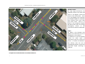
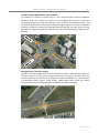
1
Auckland Transport
Database Operations Manual
(ATDOM1) May 2013
Auckland Transport – Database Operations Manual
1
i
Contents
1 INTRODUCTION ................................................................................................................................. 3
1.1 Purpose .............................................................................................................................. 3
1.2 Objectives ........................................................................................................................... 3
1.3 Scope of High Priority Tables ............................................................................................... 3
1.4 Previous High Priority Recommendations from RAMM Status Report .................................. 4
1.5 RAMM Database Metadata Specifications ........................................................................... 4
1.6 RAMM Knowledge .............................................................................................................. 4
2 BACKGROUND ................................................................................................................................... 5
2.1 Formation of Auckland Council ............................................................................................ 5
2.2 Database Amalgamation ..................................................................................................... 5
2.3 Consistency of Policy ........................................................................................................... 5
2.4 Collaborative Approach – Data Custodians .......................................................................... 5
2.5 Future Actions ..................................................................................................................... 5
3 REFERENCE DOCUMENTS .................................................................................................................. 7
4 RAMM TABLES .................................................................................................................................. 8
4.1 Carriageways....................................................................................................................... 8
4.2 Carriageway Surfacings ..................................................................................................... 28
4.3 Footpath ........................................................................................................................... 35
4.4 Forward Work Programme Treatments ............................................................................. 53
4.5 Loading ............................................................................................................................. 56
4.6 Maintenance Costs............................................................................................................ 59
4.7 Pavement Layer ................................................................................................................ 62
4.8 Road Names ...................................................................................................................... 69
4.9 Traffic ............................................................................................................................... 75
4.10 Treatment Length (Maintenance) ...................................................................................... 78
5 DATA DICTIONARY .......................................................................................................................... 83
5.1 Carriageway Data Dictionary ............................................................................................. 83
5.2 Carriageway Surfacing Data Dictionary ............................................................................ 102
5.3 Footpath Data Dictionary ................................................................................................ 114
5.4 Loading Data Dictionary .................................................................................................. 131
5.5 Maintenance Cost Data Dictionary .................................................................................. 141
5.6 Pavement Layer Data Dictionary ..................................................................................... 148
5.7 Roadnames Data Dictionary ............................................................................................ 156
5.8 Traffic Data Dictionary..................................................................................................... 160
6 DATA COLLECTION FORMS ................................................................................................................ 1
|
Auckland Transport
Auckland Transport – Database Operations Manual
1
OVERVIEW
The merging of seven individual asset registers into one reinforced the need for an overall Auckland
Transport Database Operations Manual (ATDOM). Analysis of the individual sets (as outlined in the
previous RAMM Status Report) clearly reinforced the industry need for a local authority equivalent of
the State Highway Database Operations Manual (SHDOM) to improve consistency, accuracy and
completeness of the Auckland Transport Asset Register. Typical examples include duplicated lookup
codes for the same activity, significant variation in population of tables and individual fields, and
evidence of different approaches in terms of management of treatment lengths and forward work
programming.
Robust asset management decision making relies upon the accuracy, completeness and consistency of
information contained in the asset register. This includes quantity, location, condition and value of all
assets owned and maintained by Auckland Transport. When this information is to the appropriate
standard, reliable and accurate renewal and replacement programmes, with respective funding
requirements can be developed.
The reliability and confidence of decision support outcomes is directly linked to the quality of the asset
register data. Generally this comes from the asset management information system, which can
originate from a single source or multiple sources.
In order to obtain a consistent, accurate, complete and up to date asset register, systems and
processes are required. This includes documentation of data collection methodologies, data entry
checks and ongoing continuous validation to provide total database management.
This Manual is the starting point to developing an overarching document for Auckland Transport and
their suppliers. It sets out a database management framework for the collection, delivery,
management and desktop validation of road asset inventory and some core condition data. This first
phase contains the template database operations manual for 10 key RAMM asset tables. It contains a
table overview then provides additional key information on the mandatory fields and how these are
populated (Data Dictionary). Guidance notes are provided on data collection and management for
each section.
The ATDOM is a living document that will be continually updated and developed over time. Further
work is anticipated to complete templates for outstanding tables. Any comments /suggestions should
be sent to Manager: Asset Systems and Monitoring, Auckland Transport.
|
Auckland Transport
Auckland Transport – Database Operations Manual
2
ACKNOWLEDGEMENTS
In preparation of this manual there have been a number of organisations and individuals that have
contributed. Contributions range from verbal conversations to supply of written literature and are not
in any priority order.
|
•
New Zealand Transport Agency (NZTA) – Making available electronic copy of SM050: State
Highway Database Operations Manual which is referenced in Section 4 of this document.
•
Auckland Transport (AT) Staff – For various inputs and review and taking the initiative to continue
the pursuit of more robust asset registers.
•
These organisations were involved in the consultation process for the RAMM Status Report,
portions of which are included in this report:
•
Auckland Transport
•
Downer
•
Fulton Hogan (FH)
•
RAMM Software Limited (RSL)
•
Beca (BECA)
•
Previous Local Government Organisation (LGO) staff from the various Councils
•
Opus International Consultants Ltd (OPUS)
•
Projenz.
Auckland Transport
Auckland Transport – Database Operations Manual
2
INTRODUCTION
2.1
Purpose
3
This document, in its current form, is considered to be the starting point in the overall process
of developing a complete Database Operations Manual for Auckland Transport. It outlines
methodology for both the field data collection and entry into Auckland Transport’s RAMM
database for purposely selected 10 key asset tables. The draft manual outlines what is
considered to be current best practice for the activities that were previously being undertaken
by individual Councils of the Auckland Region.
The manual is intended to provide guidance to those individuals and organisations that supply
Auckland Transport with services to deliver transportation outcomes that maintain, change,
remove or upgrade physical assets resulting in subsequent changes to the asset register.
2.2
Objectives
Phase one focused on selected high priority core asset tables identified in the RAMM Status
Report and agreed with Auckland Transport. Further work is required to complete the manual
for all tables that Auckland Transport decides to maintain. A primary objective of this first
phase was to develop and establish a framework for data collection, data entry, and
maintenance that future phases could build upon.
2.3
Scope of High Priority Tables
The 10 tables selected in phase one included:
•
Carriageway (asset)
•
Carriageway Surfacing (asset)
•
Footpath (asset)
•
Forward Work Programme Treatments (asset maintenance)
•
Loading (asset demand)
•
Maintenance Cost (asset maintenance)
•
Pavement Structure (asset)
•
Road Names (information)
•
Traffic (asset demand)
•
Treatment Length (information)
The tables have been ordered alphabetically and are not represented in order of priority.
Section five has the tables ordered in the same way for ease of finding the information
required.
|
Auckland Transport
Auckland Transport – Database Operations Manual
2.4
4
Previous High Priority Recommendations from RAMM Status Report
A number of high priority tasks were identified from the analysis undertaken while preparing
the RAMM Status Report1, one of which was creation of the Database Operations Manual. A
full commentary and supporting analysis/discussion is contained in the full report1.
2.5
RAMM Database Metadata Specifications
In the preparation of the Data Dictionary in Section five, reference has been made to the online information provided in RAMM Manager, by RAMM Software Limited (RSL). This
information has been included in the report in “good faith” as the authors are not software or
metadata experts.
2.5.1
Metadata Currency
The data collection and Data Dictionary requirements for the manual have been based
on the current operating version of RAMM for Auckland Transport’s database. At the
time of writing this report it was RAMM 2008.
2.5.2
Future Versions
The Database Operations Manual will require updating to ensure alignment with
metadata changes that occur with future versions of RAMM. Any significant changes
to table structure should be well known in advance to the industry prior to it being
released. This will enable changes in process and collection to be well understood and
documented, prior to implementation.
Where changes or additions to asset collection methodologies are agreed, then
documentation will be required to ensure consistency for the whole database. All data
providers will need to be advised to ensure homogenous metadata for the specific
asset.
2.6
RAMM Knowledge
In preparing this manual a certain level of RAMM knowledge has been assumed. To get to a
point where you are either collecting data in the field, or being responsible for database
maintenance for Auckland Transport you must have NZTA RAMM L1 or L2 certification. As a
pre-requisite, organised on the job training would have been completed to ensure familiarity
and proficiency in the required work.
1
RAMM Status Report Stage One, April 2011, Opus International Consultants Limited.
|
Auckland Transport
Auckland Transport – Database Operations Manual
2
BACKGROUND
2.1
Formation of Auckland Council
5
The establishment of Auckland Council, and its coming into power on 1 November 2010
resulted in a number of activities being implemented prior to this date. One such activity was
the creation of a single asset repository for the Council-controlled organisation of Auckland
Transport (AT).
The Road Assessment and Maintenance Management (RAMM) system has historically been the
primary transport asset repository for all Council owned and maintained assets. The creation
of Auckland Council resulted in combining seven previous Local Government Organisations
(LGO), including their RAMM databases for; Rodney District Council, North Shore City Council,
Waitakere City Council, Auckland City Council, Manukau City Council, Papakura District Council
and approximately half of Franklin District Council.
2.2
Database Amalgamation
The primary merging of the seven RAMM databases was managed by the Auckland Regional
Transport Agency (ARTA), another previous Local Government Organisation, with the work
completed by RAMM Software Limited (RSL) who are the software developers and providers of
RAMM. Part of this process included combining seven previous individual lists for each of the
700-800 lookup tables for each database, to form one for the Auckland Transport Database.
2.3
Consistency of Policy
With each of the seven databases being managed by a separate organisation there exists
differences in approach, methodology and recorded data that need to be understood,
managed and updated to provide a consistent database over time, for the whole Auckland
Council.
2.4
Collaborative Approach – Data Custodians
Responsibility around maintenance and management of the Council asset data now becomes a
joint responsibility between three main parties - Auckland Transport Systems and Monitoring,
Road Corridor Maintenance and their contractors, and three asset management consultants
each awarded one contract area, north, central and west, and south.
Therefore it is vitally important to define clear roles and responsibilities and documented
guidelines to ensure the database is maintained as one, with consistent rules and metadata
populated within each table.
2.5
Future Actions
The current form of the Auckland Transport Database Operations Manual (ATDOM) addresses
the first phase of priority actions. In order to progress the ATDOM further, the following phase
needs to be implemented:
|
Auckland Transport
Auckland Transport – Database Operations Manual
•
|
6
Complete the following tables in a format that is consistent with this phase one
document. Updated specifications such as those prepared for the recent contracts will
need to be considered (i.e. road rating in the road corridor maintenance contracts and
High Speed Data (HSD) specifications from the HSD contract):
-
Rating
-
Roughness
-
High speed roughness
-
High speed texture
-
High speed rutting
-
Drainage
-
Crossings
•
Review of all lookup tables for the matching tables that have been completed to date.
•
Finalising the form the final document be made available (such as web based and
downloadable in PDF format), and how to receive and incorporate feedback/ updates.
•
Development of a training and certification/accreditation process for both data
collectors and database managers to ensure the knowledge contained in ATDOM is
understood by suppliers and applied when collecting and managing the asset register.
Auckland Transport
Auckland Transport – Database Operations Manual
3
7
REFERENCE DOCUMENTS
The following publications and manuals have been referred to for this work:
|
•
State Highway Database Operations Manual, SM050, New Zealand Transport Agency, May 2009.
•
Franklin District Council RAMM Database Operations Manual, Opus Consultants Limited, 2010.
•
Manukau City Council RAMM Database Operational Requirements, Opus International Consultants
Limited, February 2012 revision.
•
RAMM Computer Users’ Manual, CJN Technologies Ltd, 1998.
•
This is commonly referred to as the “Yellow Book”, as it was contained in a yellow ring binder.
•
Local Authority Database Operations Manual,PFM7, Transfund New Zealand, 1997.
•
Work Instruction for Waitakere City Council Road Network Treatment Lengths and Forward Works
Programme 2009, Opus International Consultants Limited, October : 2009.
•
Auckland Transports Code of Practice, As Built Data Requirements.
Auckland Transport
Auckland Transport – Database Operations Manual
4
8
RAMM TABLES
4.1 Carriageways
4.1.1
What is a Carriageway?
The RAMM system defines a carriageway as a section of road with homogenous traffic
and loading volumes, pavement type (sealed, unsealed, structural, bridge), width,
number of lanes and urban/rural classification along its length. The organisational (i.e.:
maintenance contractor) and administrational (i.e. ward or sub area) aspects of the
road also need to be homogenous over the length of a carriageway section.
A road may be broken down into multiple carriageway sections if any of the above
criteria change along its length such as:
4.1.2
•
The number of lanes change, i.e. from 2 to 3 (at the start of a passing lane).
•
The speed limit changes to greater than 70km/hr (urban to rural).
•
The width changes by more than 2.5m over a significant length (typically >100m).
•
Traffic volumes and/or composition change significantly such as at major
intersections.
•
The road changes in surface type i.e. sealed to unsealed, thin surface flexible to
bridge.
Why is this Table Important?
The Carriageway Table contains dimension and road section characteristics and provides
the principal framework for all road reserve assets to be attached to. Specifically, the
RAMM Carriageway Table includes:
4.1.3
•
Dimensional characteristics such as length, width, number of lanes, area and road
reserve width.
•
Political boundary information such as ward and community board areas.
•
Urban and rural classification based on the NZTA definitions.
•
Information on the length of sealed and unsealed roads in the network.
•
NZTA maintenance group classification.
•
Other general characteristics such as road class, pavement type, hierarchy, traffic
volume and loading, traffic management levels and average roughness data.
What is the Carriageway Table Used For?
The RAMM Carriageway Table is Auckland Transport’s primary repository for all locational,
dimensional, organisational and summary statistical information for each road section. The
table can be used to produce carriageway lists, report network lengths by centreline and
|
Auckland Transport
Auckland Transport – Database Operations Manual
9
lane length, and undertake further network length analysis by urban/rural, pavement type,
maintenance area and maintenance category.
The actual sectioning of the road to create carriageway sections is detailed in this table.
The same sectioning is used for all other asset tables in the database. The Treatment
Length Table is the only table that does not use this sectioning method. However,
treatment lengths be sectioned by carriageways or, more typically, using the top surface
seal seams.
4.1.4
What Activities Affect this Table?
There are 10 key activities listed that affect the Carriageway Table in terms of physical
changes to the asset that must be captured in RAMM to keep the table up to date. The
activities include but are not limited to:
4.1.5
•
New road construction - new carriageway sections need to be generated.
•
Existing road reconstruction (sometimes) that can result in changes to the pavement
type from thin surfaced flexible to structural asphaltic concrete pavement.
•
Changes to existing carriageway nodes resulting from new road construction.
•
Changes to existing carriageway nodes resulting from carriageway reviews.
•
Seal extensions, as this changes some of the characteristic fields such as pavement
type and usually width.
•
Seal widening projects as this affects the width.
•
Minor safety works that result in additional lanes at intersections, creating new
carriageway sections as a result of changes to the carriageway width and number of
lanes.
•
Speed review changes, as the section may change from rural to urban.
•
Political/maintenance boundary changes.
•
Other works that create a change to the existing data held within the Carriageway
Table.
Who Provides the Data?
The supplier carrying out the physical work resulting in changes to the Carriageway Table is
typically responsible for the provision of Carriageway data that is compatible with RAMM.
Database managers are required to ensure that all major work activities that could impact
on the Carriageway Table are identified and the appropriate changes made to the RAMM
database.
|
Auckland Transport
Auckland Transport – Database Operations Manual
4.1.6
10
What Fields are Collected and Why?
The Carriageway Data Dictionary (appended) outlines the data that must be collected and
provided by suppliers carrying out activities that affect the Carriageway Table. This data is
required to ensure that the objectives of the Carriageway Table can be met.
4.1.7
What Resources are Required to Collect Carriageway Data?
To collect Carriageway data, you will need the following equipment and reference material:
4.1.8
•
ATDOM which will assist you in identifying what specific data is required.
•
Current carriageway list which shows road ID’s, road names, start and end locations
and descriptions for each road.
•
A calibrated vehicle tripmeter (with completed calibration form) accurate to 1m per
1000m (+/- 0.1%).
•
A calibrated measuring wheel (with completed calibration form) accurate to 0.1m per
100m (+/- 0.1%).
•
Whatever electronic device your organisation needs to download the data from the
counter.
•
An approved traffic management plan for the work activity to be undertaken.
•
RAMM data collection forms (or equivalent).
How is the Database Updated?
The Carriageway Data Dictionary (appended) provides additional guidance to database
technicians who have read/write access to the RAMM Carriageway Table. The database
can be updated using 3 methods:
|
•
Automated bulk uploading of Carriageway data through the RAMM Manager data
import facility (preferred method for large amounts of load data but not the typical
approach).
•
Manual updating of some minor attribute data in RAMM for Windows (preferred
method for making those small minor changes such as changes to start and end
names).
•
All manual major or significant changes to dimensional related data can be done
through RAMM Network Manager, including adding new sections, splitting, joining and
deletion. Unsealed to sealed changes to carriageway sections can also be made in
RAMM Network Manager. Database managers require specific training in the use of
RAMM Network Manager before using this module to ensure the desired outcome is
obtained.
Auckland Transport
Auckland Transport – Database Operations Manual
4.1.9
11
How Can this Database Operations Manual Help You?
Accompanying this table overview is the following sections:
•
RAMM Carriageway Data Collection Guide Notes and FAQ’s (Section 4.1.10) includes diagrams and illustrations around standard Carriageway data collection
conventions to ensure the data is collected consistently in the field. Some typical
FAQ’s are also provided.
•
Carriageway Data Dictionary (appended) provides a column by column description of
the Carriageway table including what data is required, how it is collected, entered
and managed and what are the allowable values.
Collectively, these documents are designed to assist both data collectors and database
managers achieve the ultimate outcome of accurate, consistent and up to date data.
4.1.10 RAMM Carriageway Data Collection Guide Notes and FAQ’s
The following guide notes are to be used as a reference when carrying out activities that
affect the RAMM Carriageway updates. The guide notes cover all the necessary
information to collect RAMM Carriageway data in a consistent and accurate manner for all
the mandatory fields that are required.
Survey Direction
Existing conventions need to be considered regarding survey direction. Auckland Transport
may require roads surveyed in a specific direction. However, when validating or setting up
a new database, roads should be surveyed from the major traffic end to the minor traffic
end as follows:
•
Arterial road to collector road.
•
Collector road to local road.
•
Local road to the end of the road or to the cul-de-sac end.
Exceptions to this are one way roads where traffic flow dictates the survey direction.
Minimum and Maximum Carriageway Lengths
As described above, changes in width, number of lanes, urban/rural, pavement type, traffic
volumes and administrational areas require a new carriageway section. However, to avoid
the proliferation of short carriageway sections (such as changes to no. of lanes around
signalised intersections, or short bridges) the following guidelines apply:
|
•
Urban area - minimum carriageway length 30m, maximum carriageway length
1500m.
•
Rural area - minimum carriageway length 50m, maximum carriageway length
3,000m.
Auckland Transport
Auckland Transport – Database Operations Manual
12
Exceptions to these should be avoided but will be required in certain circumstances.
Generally the length of a carriageway section is equal to the end metres minus the start
metres. However, for first carriageway section of most roads starting from a three way or
four way intersection, the length needs to be adjusted to be the “end metres minus the
start metres” less the distance between the intersecting centreline of each road to the kerb
line. This length adjustment needs to be completed using the length adjustment option.
This also needs to be done for roads that end at a three way or four way intersection.
Diagram 4.1.1 demonstrates this length adjustment.
End = 84m
Adjusted Length (80m)
Distance from centreline to kerb = 4m
Start = 0m-located at intersecting centrelines
Diagram 4.1.1: Example of Carriageway Length Adjustment
|
Auckland Transport
Auckland Transport – Database Operations Manual
13
Carriageway Table Data
The following data is non-dimensional data that cannot be measured on site but is still
required for collection. Guidance is provided below on how this data is assessed.
Carriageway Field
Assessment Method
Pavement Type (B, C, S, T, U)
Based on visual assessment on site.
Pavement Use (1, 2, 3, 4, 5, 6, 7)
This depends upon the average daily
traffic. Generally the traffic count data
provided in the database will be used to
determine the pavement use. For new
sub-divisional roads, a rate of 1 vehicle
movement per meter of total road length
is used as a basis to estimate number of
vehicles per day.
The numbers of marked traffic lanes are
counted. This may vary from road to
road. Unmarked roads less than 4m wide
are considered one lane.
The NZTA definition for urban is any road
section that has a posted speed limit of
70 km/hr or less (i.e10, 20, 30, 40, 50, 60,
70km/hr). Rural road sections have a
posted speed limit of > 70 km/hr (i.e. 80,
90, 100km/hr).
This information is entered from
ward/sub area maps provided by
Auckland Transport.
This is determined from road hierarchy
maps provided by Auckland Transport.
Typically they are from the District Plan.
Lanes (1, 2, 3, 4, 5, 6, 7, 8)
Urban/Rural (U, R)
Carriageway Area
Hierarchy
|
Additional Notes
B, C, and U are obvious. You may need
access to as-built drawings to
differentiate between T and S for
carriageways surfaced with AC.
Review the count and estimate data for
surrounding carriageway sections to
assist in calculating a reasonable estimate
of AADT, which then can be used to
assign a pavement use band to the
carriageway section.
For divided median sections
(northbound/southbound) the number of
lanes in each direction are used.
Auckland Transport
Auckland Transport – Database Operations Manual
14
Divided Carriageways (Full length)
Where a road has a physical median that separates each direction of travel over the full
length of the road then each side has a separate road name and road id. The road name is
suffixed in brackets with the travel direction for that road i.e. TE IRIRANGI DR
(WESTBOUND) and TE IRIRANGI DR (EASTBOUND).
Single Divided Section (Not full length of road)
If the physical median is not present for the full length, then the increasing direction
carriageway sections are contiguous (with no direction suffixed in brackets after the road
name), i.e. TE IRIRANGI DR and decreasing section are added as required (with the direction
suffixed in brackets after the road name) i.e. TE IRIRANGI DR (EASTBOUND).
Multiple Divided Sections
In the case where there is more than one divided section along the length of the road, then
the running distance continues from the end of the first divided section through to the end
of the last divided section. This will result in there being gaps between the divided sections,
as the running distance is contiguous from the start of the first divided section.
Example:
The table below shows an example of a road that has multiple divided sections along its
length.
Roadname
Start m
End m
Start name
Redoubt Rd
0
1000
John Rd
Redoubt Rd
1000
1500
Redoubt Rd
1500
2000
Redoubt Rd
2000
2500
Redoubt Rd
2500
2800
Redoubt Rd
(Westbound)
Redoubt Rd
(Westbound)
0
500
1000
1500
Start divided
median
End divided
median
Smith Rd (Start
divided median)
End divided
median
Start divided
median
Start divided
median
End name
No. lanes
Width
Start divided
median
End divided
median
Smith Rd (Start
divided median)
End divided
median
Hill Rd
4
20
2
10
4
20
2
10
4
20
Smith Rd (End
divided median)
End divided
median
2
10
2
10
Note that Redoubt Rd (Westbound) is measured in the direction of the traffic, and the start
node for the section is 0, not 300 (i.e. 2800 minus 2500), i.e. do not confuse this approach
with the NZTA approach for increasing/decreasing sections of State Highway).
|
Auckland Transport
Auckland Transport – Database Operations Manual
15
Diagram 4.1.2: Example of Multiple Divided Sections
Divided Road (Eastbound)
Divided Road (Westbound)
Road A
0m point for Road A in a
divided road situation
Diagram 4.1.3: Zero Point for Side Road Onto a Divided Road
|
Auckland Transport
Auckland Transport – Database Operations Manual
16
Creating Carriageway Sections
Each road will have carriageway sections established using the standard rules for creating
carriageway sections such as:
At an intersection: Generally in urban areas carriageway breaks occur at all
intersections, expect for intersections that are very close together (<30m). For rural
roads intersections may be too far apart, so another obvious and easily locatable but
permanent physical feature such as a catchpit, box culvert, transformer or power
pole may be used. Rural carriageway sections generally should not exceed 3km.
•
Change in pavement type: i.e. thin surfaced flexible (T) to structural asphaltic
concrete (S), or T to unsealed (U), or to a bridge deck (B), etc. Typically bridges
longer than 50m have their own carriageway section.
•
Significant changes in traffic volume: which occurs around major intersections and
major accesses.
•
Changes in organisational area: as recorded in the area field (i.e.: ward change).
•
Change in ownership: i.e. end of public road and start of private road.
•
Significant width changes: i.e. a lane gain or drop, or width change >2.5m for a
length of 100m or more.
•
A change from urban road (<=70 km/hr) to rural road (>70km/hr), as defined by the
NZTA definition.
ROAD SECTION
KELLY GROVE
SH A
•
GREEN STREET
SH A
ROAD SECTION
BLACK ROAD
ROAD SECTION
WHITE ROAD
ROAD SECTION
ROAD SECTION
SH A
Diagram 4.1.3: Example of Carriageway Sectioning
|
Auckland Transport
Auckland Transport – Database Operations Manual
17
Roundabouts:
All large roundabouts are surveyed as a separate road. Roundabouts are deemed large if
approach islands are present. Small roundabouts, such as small domes or roundabouts
with painted traversable islands are treated like standard intersections.
Starts and ends at
intersecting Road, e.g., 0
– 67m
William St
Roundabouts are named as follows:
“MAJOR ROAD NAME/MINOR ROAD NAME RAB”, e.g. “GREAT SOUTH/WILLIAM RAB Note
that the street suffixes are excluded in the road name. The start and end names are e.g.:
“WILLIAM ST – WILLIAM ST” and include the suffixes. For two major roads, or roads of the
same hierarchy, naming is ordered alphabetically.
Great South Rd
Great South Rd
William St
Roundabout area considered as a
separate road. Road named as:
GREAT SOUTH/WILLIAM RAB
Diagram 4.1.4: Roundabout Treated as a Separate Road
Additional Notes:
Great South Road is the major road, so the naming convention is GREAT SOUTH/WILLIAM
RAB, with start/end names 0 – 67, WILLIAM ST (NORTH) – WILLIAM ST (NORTH).
|
Auckland Transport
Auckland Transport – Database Operations Manual
18
Roundabout Intersecting Roads:
Where roads start, end or intersect a roundabout, the carriageway sections will start/end at
the roundabout approach islands. The island nose closest to the roundabout itself is used as
the start/end point.
William St
Where a road passes through the roundabout, the displacements are measured between
the approach islands and a gap is in the displacements. The “gap” allows high speed data
to be continuous when passing through the roundabout. This is illustrated in Diagram 4.1.5
below:
Carriageway section end point
(End of approach island), e.g.,
0 - 1050m.
Carriageway section start point
(Start of approach island), e.g.,
1087 - 2160m.
1050m
1087m
To Garden Cres
From SH 2
Great South Rd
Roundabout area considered as a
separate road.
Diagram 4.1.5: Example of Carriageway Sectioning of a Road Through a Roundabout
Example:
GREAT SOUTH RD, carriageways 0 – 1050m, SH 2 – WILLIAM ST and 1087 – 2160m,
WILLIAM ST – GARDEN CRES. Note that a gap exists between the displacements. Any other
roads that start or end at roundabouts start/end at the approach islands do not encroach
on the roundabout area.
|
Auckland Transport
Auckland Transport – Database Operations Manual
19
Cul-De-Sacs:
The following describes how cul-de-sacs are surveyed, with respect to end position of the
last carriageway section. Cul-de-sacs with small islands are treated like standard cul-desacs, measuring the extreme most point. Diagram 4.1.6 shows a standard cul-de-sac, with
Diagram 4.1.7 having a small island.
Cul-de-sacs with large islands are surveyed by splitting the carriageway at the start of the
island nose when approaching the cul-de-sac, driving around the loop, and ending the
carriageway at the same point when exiting the cul-de-sac head. This is shown in Diagram
4.1.8.
Cul-de-sac head extremity126m
William St
Miscellaneous Extra Area
126m
Great South Rd
Diagram 4.1.6: Definition of a Cul-de-sac Carriageway Section
The carriageway section for William Street will be as follows:
0 – 126m, GREAT SOUTH RD – CUL-DE-SAC
|
Auckland Transport
Auckland Transport – Database Operations Manual
20
Cul-de-sac Head with Small Island
Cul-de-sacs with small islands that can be driven past without deviation through the cul-desac turning area to the end of the road will be treated like a normal cul-de sac, as shown in
Diagram 4.1.7 below.
Cul-de-sac head extremity
175m
William St
Miscellaneous Extra Area
Intersection Extra Areas
0m
Great South Rd
Diagram 4.1.7: Definition of a Cul-de-sac With Small Head Island Carriageway Section
The carriageway section for Williams Street will be as follows:
0 – 175m, GREAT SOUTH RD – CUL-DE-SAC.
|
Auckland Transport
Auckland Transport – Database Operations Manual
21
Cul-de-sac Head with Large Island
Always collect data
clockwise direction.
in
Create carriageway
adjacent island nose
split
178m
96m
Intersection Extra Areas
William St
Miscellaneous Extra Area
0m
Great South Rd
Diagram 4.1.8: Definition of a Cul-de-sac With Large Head Island Carriageway Section
The carriageway section for Williams St will be as follows:
0 – 96m, GREAT SOUTH RD – START ISLAND RHS
96 – 178m, START ISLAND RHS – END ISLAND RHS
Note: The last carriageway section is usually only one lane.
|
Auckland Transport
Auckland Transport – Database Operations Manual
22
Hammerheads
For roads with hammerheads, set the main access road and hammerhead up as separate
roads, e.g., WILLIAM ST and WILLIAM ST HAMMERHEAD. Survey the main access road from
the road origin to the centreline of the hammerhead. Survey the hammer head from one
cul-de-sac through to the other, describing the start and end points, e.g., CUL-DE-SAC
(SOUTH). It is also desirable to create a carriageway split where the main road intersects to
avoid any confusion regarding which end to start the survey. This is shown in the diagram
below.
If the orientation of the hammerhead section is not obvious (i.e.: hammerhead does not
run from east to west or north to south) then house numbers may be used to describe the
start end and name fields of the hammerhead.
William St Hammerhead
0m
60m
125m
William St
52m
0m
Great South Rd
Diagram 4.1.9: Definition of a Hammerhead Carriageway Section
The carriageway section for Williams Street will be as follows:
Road 1: WILLIAM ST 0 – 52m, GREAT SOUTH RD – WILLIAM ST HAMMERHEAD
Road 2: WILLIAM ST HAMMERHEAD, 0 – 60m, CUL-DE-SAC (WEST) – WILLIAM ST and 60 –
125m, WILLIAM ST – CUL-DE-SAC (EAST).
|
Auckland Transport
Auckland Transport – Database Operations Manual
23
Loops
This case is similar to hammerheads with the loop section being set up as a separate road,
e.g., WILLIAM ST LOOP. Separating these elements into individual roads allows clear
identification of each element, and the start and end locations for each section. This is
shown in the diagram below.
William St Loop
0m
345m
William St
81m
0m
Great South Rd
Diagram 4.1.10: Definition of a Loop Carriageway Section
The carriageway section for Williams Street will be as follows:
Road 1: WILLIAM ST 0 – 81m, GREAT SOUTH RD – WILLIAM ST LOOP
Road 2: WILLIAM ST LOOP 0 – 345m, WILLIAM ST – WILLIAM ST
|
Auckland Transport
Auckland Transport – Database Operations Manual
24
Intersections
In the interests of accuracy, an attempt has been made to reduce the amount of ambiguity
that exists at intersections. The following rules have been applied when determining
carriageway start/end points:
•
For both marked and unmarked intersections approaching at a right angle, the centre
of the intersection is used.
•
For both marked and unmarked intersections approaching at a small angle, the
centre of the intersection is used.
•
For marked intersections approaching at an acute angle, the point of the marking (or
middle of the median island) will be projected at a right angle to the road being
measured.
•
For unmarked intersections approaching at an acute angle, the middle of the
intersection will be projected at a right angle to the road being measured.
•
At all poorly defined intersections, well defined and easily locatable features such as
sumps or power poles may also be used to further define the node, e.g. SMITH ST
(SUMP LHS) – means that the node is located at Smith St adjacent a sump on the left
hand side.
The following diagrams show methodologies for dealing with typical carriageway start and
end point situations.
|
Auckland Transport
Auckland Transport – Database Operations Manual
25
Defining Carriageways Start and End Points: Right Angle Intersection
To Garden Gr
391m
William St
Great South Rd
Great South Rd
From SH 2
Start/End carriageway sections at
“Tee” of Intersection (391m)
Diagram 4.1.11: Carriageway Section Definitions for a Through Road Making a Right Angle Turn in an
Intersection
The carriageway sections for Great South Road will be as follows:
|
0 – 391m,
SH 2 – WILLIAM ST (AT TEE)
391 – 689m
WILLIAM ST (AT TEE) – GARDEN GR
Auckland Transport
Auckland Transport – Database Operations Manual
26
William St
Defining Carriageways Start and End Points: Acute Angled Intersection
Increasing direction
3016m
Great South Rd
3850m
Garden Gr
Diagram 4.1.12: Carriageway Section Definitions for Intersections at an Acute Angle
The carriageway sections for Great South Road will be as follows:
3016 – 3850m, WILLIAM ST – GARDEN GR
|
Auckland Transport
Auckland Transport – Database Operations Manual
27
Defining Carriageways Start and End Points: Two Roads Starting/Ending on Curve
To Garden Gr
0m
496mm
Great South Rd
Power Pole
Boundary Fence
Endeavour to start/end roads at a
well-defined point, e.g. power pole,
sump, corner of boundary fence,
etc.
From SH 2
William St
Sump
Diagram 4.1.13: Carriageway Section Definitions for Two Roads Starting and Ending on a Curve
The carriageway sections for both roads will be as follows:
Road 1: WILLIAM ST, carriageways 0 – 496m, SH 2 – GREAT SOUTH RD (POWERPOLE RHS)
Road 2: GREAT SOUTH RD, carriageways 0 – 1065m, WILLIAM ST (POWERPOLE RHS) –
GARDEN GR
|
Auckland Transport
Auckland Transport – Database Operations Manual
4.2
28
Carriageway Surfacings
4.2.1
Why is this Table Important?
The RAMM Carriageway Surfacings table provides a logical place to store current and
historic surfacing data such as chipseals, asphalts, and slurries.
The accuracy of this table is absolutely critical as surfacing records contained in it represent
significant investment by Auckland Transport (AT). The table is used extensively in
conjunction with high-speed data and other condition assessment tables to undertake highlevel condition analysis. Specifically, the RAMM Carriageway Surfacings Table includes:
•
Road that the surfacing is on.
•
The start and end locations of the surfacing.
•
Surfacing dimensions such as length, width and area.
•
Surfacing material properties such as seal type and chip size, aggregate source and
properties such as PSV and ALD.
•
•
4.2.2
Surfacing function (i.e.: first coat, second coat, membrane seals and reseals).
•
Surfacing date.
•
Surfacing additives (flux, cutter, adhesion).
•
Binder type and application rates.
•
Surface reason - the primary reason for undertaking the surfacing.
•
Design life of the surfacing - particularly if done under a performance specified P/17
specification.
Information on who carried out the surfacing work.
What is the Carriageway Surfacings Table Used For?
The RAMM Carriageway Surfacings Table is Auckland Transport’s primary repository for all
surfacing records. It contains all of the current and historical information on all resurfacing
activity, including surfacings that have been removed. A complete and accurate
Carriageway Surfacings Table is necessary to:
|
•
Create an accurate top surface profile (surface structure).
•
Provide accurate annual reporting on resurfacing achievement.
•
Provide accurate treatment selection reporting.
•
Provide input to research projects.
Auckland Transport
Auckland Transport – Database Operations Manual
•
4.2.3
29
Provide a critical input into establishing and maintaining treatment lengths and
developing a forward work programme.
What Activities Affect This Table?
There are six key activities that affect the Carriageway Surfacings Table in terms of physical
changes to the asset that must be captured in RAMM to keep the table up to date. The
activities are:
4.2.4
•
General maintenance resurfacing with chipseals, asphaltic concrete or slurries:
ensure that surface function is set to “2” for 2nd coat or “R” for reseal depending on
the function of the seal.
•
Milling of existing surfacings as a pre-treatment to further resurfacing work: ensure
that the milled surface has “removed date” populated.
•
Area wide pavement treatments (AWPT’s) where usually all existing surfaces are
removed and new pavement constructed: ensure that surface function is set to “1”,
and that all underlying surfacings have “removed date” populated.
•
Rehabilitations (including rip and remake treatments) where usually all existing
surfaces are removed and existing pavement rehabilitated: ensure that surface
function is set to “1”, and that all underlying surfacings which are removed as part of
the rehabilitation have “removed date” populated.
•
Construction projects including new roads and road realignments: ensure that
surface function is set to “1”, or “M” for membrane seals under asphaltic concrete
surfacings.
•
Seal widening projects: ensure that “offset” and “width” are populated for the
surfacings associated with seal widening activities. Generally the total combined
surface equals the carriageway width.
•
Safety projects where resurfacing was a component of the project.
•
Top surface reviews and validations.
Who Provides the Data?
The supplier carrying out the physical changes to the asset is typically responsible for the
provision of RAMM updates. Therefore in terms of the activities that affect the
Carriageway Surfacings Asset listed above, the following suppliers are responsible:
•
|
Road construction and reconstruction (including subdivisions, realignments,
widening, rehabilitations and area wide pavement treatments) - the project
consultant for the project as outlined in the as-built process.
Auckland Transport
Auckland Transport – Database Operations Manual
4.2.5
30
•
Annual resurfacing projects - the project consultant and/or contractor delivering the
resurfacing works.
•
Safety projects with a resurfacing component - the project consultant for the safety
project as outlined in the as-built process.
•
Top surface reviews - the consultant carrying out the top surface review.
What Fields are Collected and Why?
The Carriageway Surfacings Data Dictionary (appended) outlines the data that must be
collected and provided by suppliers carrying out activities that affect the Carriageway
Surfacings Table. This Data Dictionary represents the minimum data requirements to
ensure that the objectives of the surfacing table can be achieved.
4.2.6
What Resources are Required to Collect Carriageway Surfacings Data?
To collect Carriageway Surfacings data, you will need the following equipment and
reference material:
4.2.7
•
Auckland Transport’s Database Operation Manual (ATDOM) which will assist you in
identifying what specific data is required.
•
Current carriageway list which shows road ID’s, road names, start and end locations
and descriptions for each road.
•
A calibrated vehicle tripmeter (with completed calibration form) accurate to 1m per
1000m (+/- 0.1%).
•
A calibrated measuring wheel (with completed calibration form) accurate to 0.1m per
100m (+/- 0.1%).
•
Contractor surfacing records.
•
Pocket RAMM or similar device if this is your preferred method of data capture.
•
RAMM data collection forms (or equivalent).
How is the Database Updated?
The Carriageway Surfacings Data Dictionary (appended) provides additional guidance to
database managers who have read/write access to the RAMM Carriageway Surfacings
Table. The database can be updated using 2 methods:
•
|
Importing data from spreadsheets, validating and moving to the Carriageway
Surfacing Table (preferred method for loading large amounts of data such as annual
resurfacing records).
Auckland Transport
Auckland Transport – Database Operations Manual
•
31
Manual addition, updating and deleting of Carriageway Surfacings records in RAMM
for Windows (preferred method for widening, rehabilitations and other resurfacing
project where the number of records is small and the existing surfacing data requires
some manipulation).
Updating existing Carriageway Surfacings records as a result of Carriageway Surfacings
resurfacing and reconstruction projects can be complicated. The preferred way to
undertake this work is in RAMM for Windows, viewing the Carriageway Surfacings data for
each affected record in grid view, then updating in detail view. When the Carriageway
Surfacings records are updated, always view the data again in grid view to ensure there are
no overlaps or gaps in the Carriageway Surfacings data.
4.2.8
How Can This Database Operations Manual Help You?
Accompanying this Table Overview are the following sections:
•
RAMM Carriageway Surfacings Data Collection Guide Notes and FAQ’s (Section 4.2.9)
- includes diagrams and illustrations around standard Carriageway Surfacings data
collection conventions to ensure the data is collected consistently in the field. Some
typical FAQ’s are also provided.
•
Carriageway Surfacings Data Dictionary (appended) - provides a column by column
description of the Carriageway Surfacings Table including what data is required, how
it is collected, entered and managed, and what are the allowable values for each
field.
Collectively these sections are designed to assist both data collectors and database
managers achieve the ultimate outcome of accurate, consistent and up to date data.
4.2.9
RAMM Carriageway Surfacings Data Collection Guide Notes and FAQ’s
The following guide notes are to be used as a reference when carrying out activities that
affect the RAMM Carriageway Surfacings updates. The guide notes cover all the necessary
information to collect RAMM Carriageway Surfacings data in a consistent and accurate
manner for all the mandatory fields that are required.
What does “Removed Date” mean? And when do I populate it?
Removed date must be populated for surfaces that are physically removed from the
Network. Do not delete these surfaces from the database.
The Removed Date is a flag, which differentiates between surfaces that are currently on the
network and those that have been removed as part of some form of pavement renewal
activity.
Be aware that most removed surfaces do not coincide exactly with the area of pavement
renewal, so you may have to split historical records into two or more records and apply
|
Auckland Transport
Auckland Transport – Database Operations Manual
32
Removed Date only to that part of the surface which has been removed due to pavement
renewal activity.
Figure 4.2.9.1: Cross-sections of Pavement and Top Surface Before and After Pavement Renewal
How Does “Offset” Work?
The offset of a surfacing is simply the distance from the left hand edge of seal to the left
hand edge of the offset surfacing. Offset should be recorded where a lane treatment, or
widening activity (>2.5m widening) over a significant length (> 100m) is undertaken. For
example, if you construct a new 2.5m wide shoulder on the left hand side (LHS) on an
existing 6m wide road, then the shoulder widening work will have:
•
Offset = 0m
• Width = 2.5m.
The existing surfacing that runs concurrently with the shoulder widening will need to be
updated to have:
•
Offset = 2.5m
•
Width = 6.0m
•
Full width flag unchecked.
Make sure that all underlying surfaces are manipulated to match the new offsets resulting
from the construction of the shoulder widening.
If a new 2.5m wide shoulder is constructed on the right hand side (RHS) of an existing 6m
wide road then the shoulder widening will have:
•
|
Offset = 6.0m
Auckland Transport
Auckland Transport – Database Operations Manual
•
Width = 2.5m.
•
Full width flag unchecked.
33
The existing surfacing record that runs concurrently with the shoulder widening will need
the full width flag unchecked.
What is the Definition of Surface Width?
Surface width is the average of several measurements from left hand edge of seal to right
hand edge of seal. Surfaces that span one or more intersection can have a greater nominal
width than the surrounding carriageway sections as intersections are typically wider. If a
surfacing spans the full width of the carriageway, then you do not need to provide a
surfacing width - simply tick the full width flag. This avoids the proliferation of “strip seals”
running parallel to the main seals when the top surface profile of the road is generated in
the surface structure table.
Figure 4.2.9.2: Example of a surfacing with average widths
What is Surface Function?
Surface function defines a surfacing into one of the following categories:
•
|
1: 1st coat seal
Auckland Transport
Auckland Transport – Database Operations Manual
•
2: 2nd coat seal
•
M: membrane seal
•
R: reseal.
34
An accurate surfacing table will have 1st coat seals for all corresponding pavement data (>115 days older than the pavement date) and have corresponding 2nd coat seal (>6-36 months
older than the 1st coat data).
Two chip seals are commonly entered into the surfacing table as surface function 2; this is
incorrect (unless the two coat is a second coat). Use surface material to correctly code
single chip and multi-chip seals.
How do I deal with Surface Function when I put a membrane seal down?
Membrane seals are usually a chip seal waterproofing surface underlying an asphaltic
concrete surfacing. In this situation “M” should be used as the surface function for the
membrane seal and the asphaltic surfacing has a surface function of 2 (i.e.: 2nd coat seal).
How short should a resurfacing treatment be before you shouldn’t add it to RAMM?
Do not add reseal lengths that are shorter than 50m UNLESS they are valid surfacing
lengths. A reseal this length can be considered a patch (and thus shouldn’t be entered)
unless it is an expensive treatment (say AC, OGPA etc.), or the road section itself is <50m
(ramp, roundabout etc.).
When is AC no longer thin asphaltic surfacing?
Single treatment AC layers greater than 80mm are considered structural layers and need to
be incorporated in the pavement layer table, and the carriageway pavement type changed
from “T” to “S” (thin surfaced flexible to structural AC). The wearing course that sits above
the structural AC needs to be entered into the surfacing table.
Ideally the maximum thickness of thin asphaltic surfacing is 40mm, however surfaces
between 40 – 80mm are not structural, as such these would have to go in the surfacing
table.
|
Auckland Transport
Auckland Transport – Database Operations Manual
4.3
35
Footpath
4.3.1
Why is This Table Important?
The footpath table contains asset related information on all footpath and shared pathway
assets including footpaths that run parallel to the road, start at but end away from the
road, join roads and start and end away from roads. Specifically, the RAMM footpath table
includes:
4.3.2
•
Location information such as the road the footpath is on, and where the footpath
starts and ends in relation to the road, and the position of the footpath on the
berm/road reserve.
•
Dimensional information such as footpath length, width and area.
•
Physical attribute information such as the material that the footpath is made of, what
number and types of users use the footpath.
•
Other key information such as who owns and maintains the footpath, when the
footpath was constructed and surfaced, when the footpath data was collected and by
whom, when the footpath data was added to RAMM, and if the footpath record has
been changed since it was added.
What is the Footpath Table Used For?
The RAMM Footpath Table is Auckland Transport’s primary repository for all footpaths and
shared pathway asset inventory and condition information and is used for monitoring
condition, forward planning, determining levels of service, undertaking valuations and
capturing annual investment in both footpath construction and maintenance. Accurate
footpath data can also be used to spatially show footpath assets on aerial photographs or in
GIS images.
4.3.3
What Activities Affect this Table?
There are three key activities that affect the footpath table in terms of physical changes to
the asset that must be captured in RAMM to keep the table up to date. The activities are:
|
•
New subdivision construction - typically new footpaths are constructed as part of
subdivision developments - these new footpaths need to be added to RAMM.
•
Footpath maintenance/renewals - when existing footpaths are resurfaced over
significant lengths as part of footpath renewal and maintenance projects, the current
footpath data in RAMM for the affected footpaths needs to be updated.
•
Street scaping - these projects significantly affect current footpath data in RAMM and
as a result, require RAMM data updates.
Auckland Transport
Auckland Transport – Database Operations Manual
4.3.4
36
Who Provides the Data?
The supplier carrying out the physical changes to the asset is typically responsible for the
provision of RAMM updates. Therefore in terms of the activities that affect the footpath
assets listed above, the following suppliers are responsible:
4.3.5
•
New subdivision construction - the project consultant for the subdivision through the
subdivision as-built process.
•
Footpath maintenance/renewals - the project consultant and/or contractor
delivering the maintenance/renewal project through requirements of the as-built
process.
•
Street scaping - the project consultant and/or contractor delivering the street scaping
project through the requirements of the as-built process for which the work was
procured i.e. maintenance contract or capital contract.
What Fields are Collected and Why?
The Footpath Data Dictionary (appended) outlines the data that must be collected and
provided by suppliers carrying out activities that affect the Footpath Table. There are
approximately 70 fields in the Footpath Table - nearly half of these fields are mandatory.
The remaining half are either mandatory subject to certain conditions being met, optional,
not required or generated by the RAMM software or other suppliers.
The reason for the collection of this data is to ensure sufficient information is known about
footpaths (location, dimensions, age and condition) to enable intelligent and informed
asset management related decisions to be made around the future management and
maintenance of Auckland Transport’s footpath assets.
4.3.6
What Resources are Required to Collect Footpath Data?
To collect footpath data, you will need the following equipment and reference material:
|
•
ATDOM which will assist you in identifying what specific data is required.
•
Current carriageway information including Road ID’s, Road names, start and end
locations and descriptions for each road.
•
Current footpath information including Road ID’s, Road names, start and end
locations and descriptions for each footpath.
•
A calibrated vehicle tripmeter (with completed calibration form) accurate to 1m per
1000m (+/- 0.1%).
•
A calibrated measuring wheel (with completed calibration form) accurate to 0.1m per
100m (+/- 0.1%).
Auckland Transport
Auckland Transport – Database Operations Manual
4.3.7
37
•
As-built drawings for renewals and subdivision projects.
•
Pocket RAMM (or similar device approved by Auckland Transport) if this is your
preferred method of database capture.
•
RAMM data collection forms (or equivalent).
How is the Database Updated?
The Footpath Table is typically updated by suppliers sending their collected RAMM data to
Auckland Transport or a nominated consultant. Trained and certified database managers
then enter the data into RAMM. In some instances, the supplier collecting the data will also
have read/write access to the database, in which case they will update the database
directly.
The database can be updated using two methods:
•
Automated mass upload of new footpath records via the RAMM Manager data
import facility.
•
Manual addition, updating and deleting of footpath records in RAMM for Windows
(preferred) or via Pocket RAMM.
Updating existing footpath records as a result of footpath resurfacing and reconstruction
projects can be complicated. The preferred way to undertake this work is in RAMM for
Windows, viewing the footpath data for each affected record in grid view, than updating in
detail view. When the footpath records are updated, always view the data again in grid
view to ensure there are no overlaps or unwanted gaps in the footpath data. Also ensure
all relevant fields have been populated as outlined in the Footpath Data Dictionary.
The Footpath Data Dictionary provides additional guidance to trained and certified
database managers who have read/write access to the RAMM Footpath Table.
4.3.8
How Can This Database Operations Manual Help You?
Accompanying this database operations manual are the following sections:
•
RAMM Footpath Data Collection Guide Notes and FAQ’s (Section 4.3.9) -includes
diagrams and illustrations of standard footpath data collection conventions to ensure
the data is collected consistently in the field. Some typical FAQ’s are also provided.
•
Footpath Data Dictionary (appended) - provides a column by column description of
the Footpath Table including what data is required, how it is collected and entered,
and allowable values.
Collectively these documents are designed to assist both data collectors and database
managers achieve the ultimate outcome of accurate, consistent and up to date data.
|
Auckland Transport
Auckland Transport – Database Operations Manual
4.3.9
38
RAMM Footpath Data Collection Guide Notes and FAQ’s
The following guide notes are to be used as a reference when carrying out RAMM footpath
surveys. The guide notes cover all the necessary information to collect RAMM footpath
data in a consistent and accurate manner for all the mandatory fields that are required.
Key to Guide Note diagrams:
Increasing direction:
Start and end locations of footpath assets:
Carriageway nodes:
Route positions:
|
RP 326m
Auckland Transport
Auckland Transport – Database Operations Manual
39
Footpath Start Position for Normal Tee Intersection
Guidance notes: Road A only has a footpath on the RHS.
This footpath starts half way around the intersection (45
degrees for a right angle intersection) of Footpath B1 RHS
and Footpath A RHS. As there is no footpath on the LHS of
Road A, Footpath B2 RHS starts as shown in the diagram.
FAQ’s:
Q: Do vehicle crossings count as a footpath?
A: Yes, as the vehicle crossings are serving as a footpath.
You do not need to stop and start footpath assets at
vehicle crossings.
Q: Is the data for footpaths on one way or multi-lane
streets collected in the same fashion as two way streets?
A: Yes, irrespective of the number of lanes or the
directional nature of the road, the data is collected in the
same fashion.
Q: If I have a vehicle crossing with no footpath either side,
does the vehicle crossing then count as a footpath?
A: No, as the vehicle crossings’ primary purpose is as a
crossing, and not a footpath.
Footpath Start Position and End Position Around Multiple Tee Intersections
|
Auckland Transport
Auckland Transport – Database Operations Manual
40
Guidance notes:
For right angle intersections, the
footpath record for the side road
starts at 45 degrees around the
corner of the intersection. There
is no overlapping in the collection
of footpath lengths for footpaths
that transition from main roads
into minor roads. There is no
break in the contiguous footpath
B1 RHS records that runs through
carriageway section at the
intersection of Road A and Road B.
FAQ’s:
Q: Where is the footpath start
position for roads that are not at
90 degrees to one another?
A: Endeavour to start the footpath
record for these types of
intersection half way around the
corner. If all data is collected in
this fashion, then the risk of
overlapping footpath records (and
inaccurate length reporting) is
reduced.
Footpath Start and End Positions Around Roundabouts
|
Auckland Transport
Auckland Transport – Database Operations Manual
41
Extra length
Footpath A2 LHS
Extra length
Footpath A2 RHS
Extra length
Footpath A1 LHS
Guidance notes:
As Roundabouts are treated as
separate intersections, footpaths
need to start and end where the
carriageway section ends and starts
for the road running through the
roundabout (Road A).
Footpath
length beyond the end and start
positions of the carriageway section
can be added as a length adjustment.
Do not add any footpath records to
roundabout carriageway sections.
Put the additional length of
footpaths on the main road (Road A)
running through the roundabout.
Extra
length
Footpath A1 RHS
Start Position and End Position for J Footpaths (footpaths between two roads)
|
Auckland Transport
Auckland Transport – Database Operations Manual
42
Guidance notes:
The diagram shows a J Footpath
(Joins another road) connecting Road
A with Road B. This footpath is
collected from the Road A with a
start position of RP 326 on the RHS of
Road A. The footpath ends on the
RHS of Road B at RP 97. The length is
the measured distance between the
start and end position.
RP 326m
RP 97m
|
FAQ’s:
Q: Should the record for a J footpath
start on the major road or the minor
road?
A: It doesn’t matter, there needs to
be a record for the start position of
the J footpath on both roads, so
neither road has priority.
Auckland Transport
Auckland Transport – Database Operations Manual
43
Length Adjustment for a Footpath in a Cul-de-sac
Guidance notes:
Where a footpath follows around a cul-de-sac head
(as shown in the photo) the actual length around the
outside may be different to the road centre line
length. Where this is the case the additional
measured length of the footpath is added under
length adjustment field and the length adjustment
reason of “CUL DE SAC” is used. The end point for the
both the LH and RH footpath is shown by the dashed
line.
FAQ’s:
Q: As shown in the photo, it appears that the
footpath ends past the end of the road (which is the
end of the seal in the cul-de-sac shown by the arrow
head). Do I need to make the end of the footpath
greater than the length of the road?
A: No, use the same displacement for the end of road
as the footpath.
|
Auckland Transport
Auckland Transport – Database Operations Manual
44
Footpath Side
Guidance notes:
The diagram shows that the
increasing direction of Road
A runs from left to right (as
indicated by the arrow).
When looking in the direction
of the arrow, footpaths on
the LHS of the road are
coded L and footpaths on the
RHS of the road are coded R.
FAQ’s:
A: Is this approach the same
for one way or multi-lane
roads?
A: Yes, the direction of traffic
or the number of lanes
doesn’t not change this.
|
Auckland Transport
Auckland Transport – Database Operations Manual
45
Footpath Offset
Guidance notes:
Footpath offsets are the estimated distance (to the nearest
metre) from the centre of the road to the side of the
footpath closest to the road. The offset of footpath A is
shown by the white arrow.
Offset to Footpath A LHS
Offset
to
Footpath A
RHS
|
FAQ’s:
Q: How accurate do I need to be at measuring offsets?
A: You only need to estimate the offset. Therefore you only
need to record your estimated offset to the nearest metre.
Q: What do I do when the footpath asset changes along the
length of the footpath?
A: Record an average offset only. Remember, it is only an
estimated offset only.
Auckland Transport
Auckland Transport – Database Operations Manual
Footpath Position
Position
Typical Example(s)
E Footpath
46
Description
Footpath Ends away from the road
-has a start displacement but no end displacement
-has a length requiring a length adjustment
E
J Footpath
Footpath Joins another road
-has a start displacement but no end displacement
-requires a start displacement on both roads
-requires a side on each road
-has a length requiring a length adjustment
J
|
Auckland Transport
Auckland Transport – Database Operations Manual
Position
Typical Example(s)
47
Description
Footpath runs parallel to the road but flush with the Boundary.
-no mowable or landscaped berm between the road
reserve/boundary and the footpath.
-mowable or landscaped berm between the footpath and the
road/kerb.
B
Footpath runs parallel to the road but flush with the Kerb.
-no mowable or landscaped berm on the road side of the footpath.
-mowable or landscaped berm between the footpath and the
boundary.
K
L
|
Footpath Loops away and joins back onto the road.
Auckland Transport
Auckland Transport – Database Operations Manual
Position
M
R
U
W
Typical Example(s)
48
Description
Footpath runs parallel to the road in the Middle of the berm
-there is a mowable or landscaped berm on either side of the
footpath between the kerb and the boundary
Footpath starts and ends Remotely from the road
Footpath position is unknown. Note: (Not to be used.)
Footpath runs parallel to the road over the Whole berm width
-no mowable or landscaped berm between the road and the
boundary
N/A
Footpath occupying whole berm width
P
S
|
Footpath ends away from road in Park or reserve.
Note: (Not to be used)
Footpath is berm footpath for pedestrian Safety.
Note: (Not to be used)
Auckland Transport
Auckland Transport – Database Operations Manual
49
Footpath Condition
Footpath condition is the average subjective condition on a scale of 1 (excellent) to 5 (very poor) for an individual footpath section. Use the comments field to
collect information relating isolated defects that require immediate intervention. Note that detailed footpath condition data can be found in the footpath
condition rating table.
Condition
Typical Example (s)
Description
1-Excellent (new or near new
footpath)
-No defects
-Less than or equal to 5 years old
1
|
Auckland Transport
Auckland Transport – Database Operations Manual
Condition
Typical Example (s)
50
Description
2-Good (good condition but not
new)
-No defects
-Greater than 5 years old
2
3
|
3-Average (aged footpath but still
in reasonably good condition not
requiring replacement for 5-20
years, some minor defects or
repairs such as:
-cracking
-ravelling
-discolouration
-short sections (<5m) of repaired
and/or resurfaced areas
Auckland Transport
Auckland Transport – Database Operations Manual
Condition
4
|
Typical Example (s)
51
Description
4-Poor (aged footpath in poor
condition requiring replacement in
1-5 years, substantial evidence of
repairs)
-extensive defects
-trip hazards
-ravelling
-extensive sections of repairs
Auckland Transport
Auckland Transport – Database Operations Manual
Condition
5
|
Typical Example (s)
52
Description
5-Very poor (aged and deteriorated
footpath requiring replacement
immediately)
-extensive defects
-trip hazards
-chronic ravelling
-extensive cracking
-sections of failing repairs
Auckland Transport
Auckland Transport – Database Operations Manual
4.4
53
Forward Work Programme Treatments
4.4.1
Why is This Table Important?
The Treatment Definitions Table contains information regarding the treatments used in the
forward work programme (FWP). Specifically, the RAMM Treatment Definitions Table
includes:
4.4.2
•
The code representing each treatment type.
•
A description of the treatment.
•
The period of the forward work programme where the treatment is applicable.
•
The funding group that the treatment belongs to.
What is the Treatment Definitions Table Used For?
The RAMM Treatment Definitions Table is Auckland Transport’s primary repository for
information regarding possible treatments that can be entered into the forward work
programme.
4.4.3
What Activities Affect this Table?
The activities that affect the Treatment Definitions Table are when a new treatment is
being used or when an old treatment is no longer used. The table needs to be kept up to
date with all possible treatment types that are programmed to be applied to roads on the
network. Only a database manager can update the treatment definitions.
The applicable period of the FWP is important because it specifies which years the
particular treatment may be applied. For example in years 1-3 very specific treatments such
as RS35 (reseal grade 3/5) or AC10 (asphaltic concrete mix 10) can be applied and the
treatment type and specific chip size should be known. Treatments in years 4+ are less
detailed and only the general treatment type and general chip size is known. For
treatments beyond 10 years, the treatment should be very generic (CS or AC) as beyond 10
years we are unlikely to accurately predict the specific chip size.
4.4.4
Who Provides the Data and How is the Database Updated?
Database managers are responsible for making sure that the treatments contained in the
Treatment Definitions Table are an accurate representation of the treatments being
physically undertaken in the network.
4.4.5
How Can This Database Operations Manual Help You?
Accompanying this Table Overview is the following section:
|
Auckland Transport
Auckland Transport – Database Operations Manual
•
54
Forward Work Programme Treatments (Table 4.4)-provides a description of the
current Treatment Definitions Table including what treatments are available, and
what are the recommended time periods for these treatments.
Collectively these documents are designed to assist both data collectors and database
managers to achieve the ultimate outcome of accurate, consistent and up to date data.
Table 4.4: Forward Work Programme Treatments
Treatment Description
|
Treatment Code
Recommended Year
for Treatment Code
AC10
AC10
Years 1-4
AC14
AC14
Years 1-4
AC20
AC20
Years 1-4
Concrete road renewal
CONC
All years
Interlocking Blocks
INBLK
All years
Kerb & Channel
K&C
All years
Levelling course
LMIX
Years 1-4
Milling and removal (eg roundabout)
MILL
Years 1-4
Opex Maintenance
MAINT
All years
Open Graded Porous Asphalt
OGPA
All years
Overlay
OLAY
All years
Development Project (e.g. realignment)
PROJ
All years
Reconstruction
RCON
All years
Rejuvenation Seal
REJUV
All years
Recycling (cold milling)
RECY
Years 1-4
Rehabilitation
RHAB
All years
Reseal (chip unknown)
RS
Years 5+
Reseal - Small chip
RSS
Years 5+
Reseal - Big chip
RSB
Years 5+
Reseal - Multi chip
RSM
Years 5+
Reseal - single chip, grade 2
RS2
Years 1-4
Reseal – 2 and 4, two chip
RS24
Years 1-4
Reseal - racked in 2 and 4, two chip
RS24R
Years 1-4
Reseal – Sandwich Seal, grade 2 then 4
RS24S
Years 1-4
Reseal - single chip, grade 3
RS3
Years 1-4
Reseal - 3 and 5, two chip
RS35
Years 1-4
Reseal - racked in 3 and 5, two chip
RS35R
Years 1-4
Reseal - Sandwich Seal, grade 3 then 5
RS35S
Years 1-4
Reseal - single chip, grade 4
RS4
Years 1-4
Reseal Grade 4 and 6
RS46
Years 1-4
Auckland Transport
Auckland Transport – Database Operations Manual
Treatment Description
|
Treatment Code
55
Recommended Year
for Treatment Code
Reseal - racked in 4 and 6, two chip
RS46R
Years 1-4
Reseal - Sandwich Seal, grade 4 then 6
RS46S
Years 1-4
Reseal - single chip, grade 5
RS5
Years 1-4
Reseal - single chip, grade 6
RS6
Years 1-4
Second Coat Seal (chip unkn)
SC
Years 5+
Second Coat Seal, single chip, grade 2
SC2
Years 1-4
Second Coat Seal - Small chip
SCS
Years 5+
Second Coat Seal - Big chip
SCB
Years 5+
Second Coat Seal - Multi chip
SCM
Years 5+
Second Coat - 2 and 4, two chip
SC24
Years 1-4
Second Coat - racked in 2 and 4, two chip
SC24R
Years 1-4
Second Coat Seal - single chip, grade 3
SC3
Years 1-4
Second Coat Seal - 3 and 5, two chip
SC35
Years 1-4
Second Coat Seal - racked in 3 and 5, two chip
SC35R
Years 1-4
Second Coat Seal - single chip, grade 4
SC4
Years 1-4
Second Coat - 4 and 6, two chip
SC46
Years 1-4
Second Coat Seal - racked in 4 and 6, two chip
SC46R
Years 1-4
Second Coat Seal - single chip, grade 5
SC5
Years 1-4
Second Coat Seal - single chip, grade 6
SC6
Years 1-4
Seal Extension
SE
All Years
Slurry Seal
SLRY
All Years
Stone Mastic Asphalt
SMA
Years 5+
Stone Mastic Asphalt 10
SMA10
Years 1-4
Stone Mastic Asphalt 11
SMA11
Years 1-4
Stone Mastic Asphalt 14
SMA14
Years 1-4
Stabilisation (lime and or cement)
STAB
Years 1-4
Structural asphaltic concrete
STAC
All Years
Seal widening
SW
All Years
Thin Asphaltic Concrete
TAC
Years 5+
Texturising Seal
TEXT
All Years
TNZ10
TNZ10
Years 1-4
TNZ15
TNZ15
Years 1-4
Ultra Thin Asphaltic Concrete
UTA
Years 1-4
Void Filling
VF
Years 1-4
Wheel track rutting
WRUT
Years 1-4
Water cutting
WTCT
All Years
Auckland Transport
Auckland Transport – Database Operations Manual
4.5
56
Loading
4.5.1
Why is This Table Important?
The Loading Table contains details on the composition of vehicle flow namely classification
bins as per NZTA 2011 classification requirements. Specifically, the RAMM Loading Table
includes:
4.5.2
•
Loading classification for carriageway sections relating to both physical counts and
estimates. Default values are also provided where there are no counts or estimates
based on urban-rural and carriageway hierarchy criteria.
•
Dates relating to when the last loading count/estimate was updated/added into the
database.
•
Classification history at a particular location.
•
Notes in relation to the loading survey.
What is the Loading Table Used For?
The RAMM Loading Table is Auckland Transport’s primary repository for all classified count
data and loading estimate data. Loading information is an important parameter in
pavement design, economic evaluations and for higher level asset management tools such
as forward work programming, treatment selection analysis, pavement deterioration
modelling and asset valuation.
4.5.3
What Activities Affect this Table?
There are three key activities that affect the Loading Table in terms of physical changes to
the asset that must be captured in RAMM to keep the table up to date. The activities are:
4.5.4
•
Changes to carriageway nodes resulting from new road construction or carriageway
reviews.
•
Classified traffic counting.
•
Traffic and loading estimate reviews.
Who Provides the Data?
The supplier carrying out the classified counting is typically responsible for the provision of
loading counting data that is compatible with RAMM. Database managers are responsible
for amending the estimates contained in the Loading Table when making changes the
carriageway sections.
|
Auckland Transport
Auckland Transport – Database Operations Manual
4.5.5
57
What Fields are Collected and Why?
The Loading Data Dictionary (appended) outlines the data that must be collected and
provided by suppliers carrying out activities that affect the Loading Table.
4.5.6
What Resources are Required to Collect Loading Data?
To collect Loading data, you will need the following equipment and reference material:
4.5.7
•
ATDOM which will assist you in identifying what specific data is required.
•
Current carriageway list which shows Road ID’s, road names, start and end locations
and descriptions for each road.
•
A classified counting programme approved by Auckland Transport.
•
Calibrated, certified and accurate classified counting equipment.
•
A calibrated vehicle tripmeter (with completed calibration form) accurate to 1m per
1000m (+/- 0.1%).
•
A calibrated measuring wheel (with completed calibration form) accurate to 0.1m per
100m (+/- 0.1%).
•
Whatever electronic device your organisation needs to download the data from the
counter.
•
An approved traffic management plan for collecting classified count data.
•
RAMM data collection forms (or equivalent).
How is the Database Updated?
The Loading Data Dictionary (appended) provides additional guidance to database
managers who have read/write access to the RAMM Loading table. The database can be
updated using four methods:
|
•
Automated uploading of bulk loading count data through the RAMM Manager data
import facility (preferred).
•
Manual addition, updating and deleting of loading records in RAMM for Windows.
•
Manual updating of the estimates when making carriageway changes.
•
Automated updating of estimates based on current loading count data if a network
estimate model exists.
Auckland Transport
Auckland Transport – Database Operations Manual
4.5.8
58
How Can This Database Operations Manual Help You?
Accompanying this Database Operations Manual are the following sections:
•
AT Data Template format as required by AT.
•
Loading Data Dictionary (appended) - provides a column by column description of the
RAMM Loading Table including what data is required, how it is collected, entered and
managed, and what are the allowable values.
Collectively these documents are designed to assist both data collectors and database
managers achieve the ultimate outcome of accurate, consistent and up to date data.
|
Auckland Transport
Auckland Transport – Database Operations Manual
4.6
59
Maintenance Costs
4.6.1
Why is this Table Important?
The Maintenance Cost Table contains information regarding specific road asset
maintenance activities undertaken within the Auckland Transport roading network. It
includes the normal cost activities and the associated cost for completing that activity.
Cyclic activities are not required to be loaded into this table. Specifically, the RAMM
Maintenance Cost Table includes:
4.6.2
•
Locational information such as the road, the activity that was carried out, the length,
side and position of the completed works.
•
The cost group specific to the schedule item.
•
The activity which was carried out.
•
The fault that instigated the maintenance activity.
•
The cost of the activity.
•
Quantity of the work completed for that activity.
•
Unit for quantity i.e. metres, square metres, each etc.
•
The date the activity was carried out.
•
The ability to tag items to a budget code, so that spent to date and remaining budget
can be calculated.
What is the Maintenance Cost Table Used For?
The RAMM Maintenance Cost Table is Auckland Transport’s primary repository for all
maintenance related activities of their road assets (this generally excludes annual renewals
such as pavement rehabilitation and resurfacing). This table provides detailed information
including cost, quantity, position, activity type and when the maintenance activity was
carried out. This table is used for the following purposes:
|
•
As a key input into pavement predictive modelling.
•
Optimised decision making process at a strategic level (i.e.: net present value analysis
or whole of life cost analysis).
•
Annual funding allocation process.
•
Preparing estimates for maintenance contracts.
•
Asset condition monitoring and development of maintenance cost curves.
Auckland Transport
Auckland Transport – Database Operations Manual
4.6.3
60
What Activities Affect this Table?
The following types of typical maintenance activities need to be recorded as maintenance
costs and entered into the RAMM Maintenance Cost Table:
•
Digout repairs for a section of failed pavement.
•
Milling repairs for a section of failed asphaltic concrete surfacing.
•
Replacement of vandalised signs.
•
Filling of a pothole on a suburban street.
•
Repairs to a concrete footpath.
•
Grading unsealed roads.
It is important to note that not all maintenance cost activities affect the Maintenance Cost
Table.
4.6.4
Who Provides the Data?
The supplier carrying out the maintenance activities is responsible for the provision of
RAMM maintenance cost updates. They are also responsible for transferring the
maintenance cost data into the Maintenance Cost Table on a monthly basis. Specific
activities and the supplier responsible are shown below:
4.6.5
•
Maintenance activities - the project consultant and/or contractor delivering the
maintenance/renewal project.
•
Scheduled items - the consultant and/or contractor is responsible for defining the
schedule items with the right cost, activity and fault codes.
•
Auditing - the consultant and/or contractor who is auditing the data prior to or after
transferring the data into the RAMM Maintenance Cost Table.
What Fields are Collected and Why?
The Maintenance Cost Data Dictionary outlines the data that must be collected and
provided by suppliers carrying out activities that affect the Maintenance Cost Table. These
are the minimum data requirements that will ensure that the maintenance cost data
contained in RAMM can be used for its intended purposes as discussed above.
4.6.6
What Resources are Required to Collect Maintenance Cost Data?
To collect maintenance data, you will need the following equipment and reference
material:
•
|
ATDOM which will assist you in identifying what specific data is required.
Auckland Transport
Auckland Transport – Database Operations Manual
4.6.7
61
•
Current carriageway information including Road ID’s, Road names, start and end
locations and descriptions for each road. This will assist you in locating yourself
correctly on the network.
•
A calibrated vehicle tripmeter (with completed calibration form) accurate to 1m per
1000m (+/- 0.1%).
•
A calibrated measuring wheel (with completed calibration form) accurate to 0.1m per
100m (+/- 0.1%).
•
Pocket RAMM (or similar device approved by Auckland Transport) if this is your
preferred method of data capture.
•
RAMM data collection forms (or equivalent).
How is the Database Updated?
The Maintenance Cost Data Dictionary (appended) provides additional guidance to
database managers who have read/write access to the RAMM Maintenance Cost Table.
The database can be updated using two methods:
•
Automated upload of bulk Maintenance cost data through the RAMM Manager data
import facility on a monthly basis - this is the preferred method and is required by AT
unless specified differently in existing contracts.
•
Transfer of Maintenance cost data through RAMM Contractor on a monthly basis –
this is NOT the preferred option as there is insufficient validation checks of the data
via loading.
Maintenance cost data needs to be loaded in monthly batches.
RCI updates are maintained by RAMM Software Limited.
Note that maintenance cost data is only deleted when a road is realigned. Those
maintenance cost records that were attached to the section of road that has been bypassed
can be deleted.
4.6.8
How Can This Database Operations Manual Help You?
Accompanying this Database Operations Manual is the following section:
•
Maintenance Cost Data Dictionary (appended) - provides a column by column
description of the Maintenance Cost Table including what data is required, how it is
collected, entered and managed, and what are the allowable values.
This document is designed to assist both data collectors and database managers achieve
the ultimate outcome of accurate, consistent and up to date data.
|
Auckland Transport
Auckland Transport – Database Operations Manual
4.7
62
Pavement Layer
4.7.1
Why is this Table Important?
The Pavement Layer Table is to store information, both historical and current, on the
structural pavement layers, including the sub-grade underneath the pavement. This
includes a single treatment structural asphaltic pavement layer with a total design depth >
80mm.
Since it is impossible to verify the composition of the structural layers beneath a pavement
once it has been sealed, it is critical that this information is provided or recorded at the
time of construction.
A further source of valuable information on pavement strength and layer depth is the
information obtained when test-pits are carried out (note that testpit data can be stored in
the pave_test_pit table).
Specifically, the RAMM Pavement Layer Table includes:
4.7.2
•
Start and end locations of the pavement layer.
•
Length, width, thickness and offset of the pavement layer.
•
Type, composition, source and strength of the pavement layer.
•
Date the layer was constructed, reconstructed or removed.
•
Stabilisation agents that may have been used to strengthen the pavement layer.
What is the Pavement Layer Table Used For?
Its primary use is for providing accurate contributing data towards:
4.7.3
•
An accurate pavement structure table.
•
Comparing with national annual achievement reporting for pavement renewal
projects to NZTA.
•
The development of the pavement deterioration model.
What Activities Affect this Table?
There are five key activities that affect the Pavement Layer Table in terms of physical
changes to the asset that must be captured in RAMM to keep the table up to date. The
activities are:
|
•
New road construction (i.e.: new subdivision roads and realignments).
•
Road reconstruction (i.e.: rehabilitation).
Auckland Transport
Auckland Transport – Database Operations Manual
4.7.4
63
•
Rip and remake projects.
•
Structural AC projects.
•
Testpit investigation which usually provides some information on pavement thickness
and subgrade properties should be added, or used to validate existing data.
Who Provides the Data?
The supplier carrying out the physical changes to the asset is typically responsible for the
provision of RAMM updates. Therefore in terms of the activities that affect the Pavement
Layer asset listed above, the following suppliers are responsible:
4.7.5
•
New road construction (including subdivisions and realignments) - the project
consultant for the subdivision as specified in the as-built process.
•
Pavement layer maintenance (including rip and remake, and pavement rehabilitation
projects) - the project consultant and/or contractor delivering the
maintenance/renewal project as specified in the as-built process.
•
Structural asphaltic concrete pavement projects - the project consultant and/or
contractor delivering the project as specified in the as-built process.
What Fields are Collected and Why?
The Pavement Layer Data Dictionary (appended) outlines the data that must be collected
and provided by suppliers carrying out activities that affect the Pavement Layer Table. The
dictionary defines the minimum data required to meet the requirements of an accurate and
consistent pavement layer table.
4.7.6
What Resources are Required to Collect Pavement Layer Data?
To collect Pavement Layer data, you will need the following equipment and reference
material:
|
•
ATDOM which will assist you in identifying what specific data is required.
•
Current carriageway list which shows road ID’s, road names, start and end locations
and descriptions for each road.
•
A calibrated vehicle tripmeter (with completed calibration form) accurate to 1m per
1000m (+/- 0.1%).
•
A calibrated measuring wheel (with completed calibration form) accurate to 0.1m per
100m (+/- 0.1%).
•
As-built drawings including specific information pavement designs.
•
Details on stabilisation agents including percentage and type.
Auckland Transport
Auckland Transport – Database Operations Manual
4.7.7
64
•
Pocket RAMM or similar device if this is your preferred method of data capture.
•
RAMM data collection forms (or equivalent).
How is the Database Updated?
The Pavement Layer Data Dictionary (appended) provides additional guidance to database
managers who have read/write access to the RAMM Pavement Layer Table. The database
can be updated using 2 methods:
•
Importing data from spreadsheets, validating and moving to the Carriageway
Surfacing Table (preferred method for loading large amounts of data on new road
construction where the new pavement layers have no effect on existing data as
typically there is no existing data).
•
Manual addition, updating and deleting of Pavement Layer records in RAMM for
Windows (preferred method as most new pavement layers on existing roads will
affect existing layers in some way).
In addition to the above two methods there is a tool called the Pavement Builder. Before
using this tool you should be totally familiar with what it does and be prepared to do a
check at the end to see that the outcome was what was expected. Also be aware that no
other database administrators can touch the Pavement Layer Table while you are using the
tool as it locks the table.
Updating existing pavement layer records as a result of pavement layer reconstruction
projects can be complicated. The preferred way to undertake this work is in RAMM for
Windows, viewing the pavement layer data for each affected record in grid view, than
updating in detail view. When the pavement layer records are updated, always view the
data again in grid view to ensure there are no overlaps or gaps in the pavement layer data.
It is important that a clear understanding and knowledge of how the pavement was built,
including the sequence of activities is known prior to updating the Pavement Layer Table.
4.7.8
How Can This Database Operations Manual Help You?
Accompanying this Table Overview are the following sections:
|
•
RAMM Pavement Layer Data Collection Guide Notes and FAQ’s (Section 4.7.9) includes diagrams and illustrations around standard pavement layer data collection
conventions to ensure the data is collected consistently in the field. Some typical
FAQ’s are also provided.
•
Pavement Layer Data Dictionary (appended) - provides a column by column
description of the Pavement Layer Table including what data is required, how it is
collected, entered and managed, and what are the allowable values.
Auckland Transport
Auckland Transport – Database Operations Manual
65
Collectively these documents are designed to assist both data collectors and database
managers achieve the ultimate outcome of accurate, consistent and up to date data.
4.7.9
RAMM Pavement Layer Data Collection Guide Notes and FAQ’s
The following guide notes are to be used as a reference when carrying out activities that
affect the RAMM pavement layer updates. The guide notes cover all the necessary
information to collect RAMM pavement layer data in a consistent and accurate manner for
all the mandatory fields that are required.
How do I record a granular pavement overlay project in RAMM?
An overlay is simply new pavement material placed over the top of an existing road surface.
It may or may not involve removal of existing surfaces via milling or scarifying. Where these
surfaces are not removed, the pavement layer data can be simply added to the database.
Although the surfacings data has not been physically removed, it is no longer acting as a
surface (i.e.: it is now part of the pavement layer), therefore all the surfaces under the
overlay need to have a surface_removed date entered.
If the total combined depth of surfacings under the granular overlay exceeds 50mm, then a
new pavement layer record needs to be added to the Pavement Layer Table. Use the
pavement material code “SEALS” for this layer.
How do I record a rip and remake pavement reconstruction project in RAMM?
A rip and remake will not affect the pavement layer data (unless the top layer of the
pavement is changed in thickness or stabilised in some way) but will require surfacings in
the Surfacing Table to have “removed date” populated. Make sure to add a note to the
layers affected by the rip and remake and the date the rip and remake occurred.
How do I record stabilisation of an existing pavement?
The following fields must be populated if you have stabilised an existing pavement:
•
Stabilisation material (Cement, Lime, Kiln Dust).
•
Stabilisation percentage (typically between 2 and 10).
•
Reconstructed (must be set to yes).
•
Pavement date (set this to the date that the pavement was stabilised).
This information is stored in a combination of tables.
|
Auckland Transport
Auckland Transport – Database Operations Manual
66
How do I record pavement details where I have done widening?
Pavement data is treated the same as surfacings data where widening is concerned. Refer
to surfacing section for further details. Note that the existing pavement record that runs
through the area of widening may need to be split into three records when LHS widening
occurs.
How short does a pavement layer need to be before I don’t put it into RAMM?
Any pavement renewal shorter than 50m should be loaded as a pavement repair in the
Maintenance Cost table and not loaded into the Pavement Layer table (unless the road
section is a ramp; or roundabout and is less than 50m long).
Do I need to change existing pavement layer data when I load new data?
New pavement layer data (with exception to overlays) must be “integrated” into existing
pavement layer records. This is mandatory when you have stabilised an existing layer, or
are undertaking LHS widening (refer to offsets pavement layers described below).
When do I populate the “removed_date” in the Pavement Layer Table?
If the existing pavement material has been removed or stabilised during pavement
construction then it will need to be tagged as “removed” in the Database. This is done by
populating the “removed_date” field with the date that the pavement layer material was
removed. Typically this is at least 1 day before the new pavement layer date.
This is generally done using pavement builder, such as when a pavement has been
stabilised. Pavement builder will tag the previously unbound layers as removed, and add a
new stabilised layer with material type “composite”.
What do I do when I stabilise a pavement layer but there is no data in RAMM that I can
add the stabilising details to?
In this situation, you will need to add an estimated layer to the Pavement Layer Table, then
you can add the stabilised details. Set the “estimated/known” field to “E” to show that the
record is estimated; use a default date of “01/01/xxxx” as the pavement layer date,
including specifying the year. The year can be assumed as 25 years before stabilisation, i.e.
if stabilisation has been done in 2012, the default date would be 01/01/1987. Add
additional information in the notes field to provide any other relevant information.
How do I differentiate between separate layers in a multi-layer pavement?
Typically most pavements comprise of more than one layer, e.g.: prepared subgrade
(bottom layer), GAP65-graded all passing 65mm sieve (sub base-middle layer) and GAP40graded all passing 40mm sieve (basecourse-upper or top layer). RAMM determines the
order of layers by their dates, so the older the layer the lower the layer sits relative to
surrounding layers. The youngest layer sits on top. Even if you place both GAP40 and
|
Auckland Transport
Auckland Transport – Database Operations Manual
67
GAP65 on the same day, you can nominate the GAP40 to be the top layer by assigning it a
younger date in relation to the GAP65 (one day younger will suffice).
Coat 1
19/2/2003
Gap 40
18/2/2003
Gap 65
17/2/2003
Subgrade
Figure 4.7.9.1: Example of a multi layered pavement layer. Note use of layer dates to ensure the correct
sequencing of the layers in RAMM
Worked example 1: AWPT with stabilisation from route position (RP) 0 to RP1000
You have ripped up and removed the existing surface, adding 100mm of new pavement
material (GAP40) and stabilised to a depth of 200mm using cement as a stabilisation agent
at 2%. There is no existing pavement layer data in RAMM. Once you have completed the
changes using RAMM Pavement Builder, your Pavement Layer Table (previously blank) will
now look like:
Start
m
End m
Date
0
1000
17/2/2005
0
1000
15/2/2005
0
1000
1/1/1980
Removed
Date
Est. /
Known
Material
Depth
Reconstructed
Stab
%
Stabilised
Agent
K
COMPOSITE
200
Y
2
Cement
17/2/2005
K
GAP40
100
N
17/2/2005
E
UNK
100
N
Notes:
The unknown layer dated 1/1/1980 will need to be the first layer added during the pavement builder process.
The filter for “removed date is null” will need to be cleared in order to see the removed layers.
Pavement Builder will tag the historic surfacings that runs concurrently with the AWPT as “removed”.
|
Auckland Transport
Auckland Transport – Database Operations Manual
68
Worked example 2: LHS seal widening from RP300 to RP600
You are seal widening from RP300 to RP600 at an average width of 3.5m using 150mm of
GAP65 and 100mm of GAP40. There is currently a pavement layer record from RP0 to
RP1000 as shown in the following table:
Start
m
End
m
Date
Estimated
/ Known
Material
0
1000
17/02/1990
K
GAP40
100
N
10
0
0
1000
15/02/1990
K
GAP65
150
N
10
0
Depth
Reconstructed
Width
Offset
Once you have added the widening layer to RAMM your layer data should now look like
this:
Start
m
End
m
Date
Estimated
/ Known
Material
Depth
Reconstructed
Width
Offset
0
300
17/02/1990
K
GAP40
100
N
10
0
0
300
15/02/1990
K
GAP65
150
N
10
0
300
600
17/02/1990
K
GAP40
100
N
10
3.5
300
600
15/02/1990
K
GAP65
150
N
10
3.5
300
600
16/02/2005
K
GAP40
100
N
3.5
0
300
600
15/02/2005
K
GAP65
150
N
3.5
0
600
1000
17/02/1990
K
GAP40
100
N
10
0
600
1000
15/02/1990
K
GAP65
150
N
10
0
Note: There are now eight rows of data where there were originally two. The full width flag
is unchecked, or set to “No”, for all layers within 300 to 600m.
As you will also be sealing the widening, the same propagation of data must take place in
the Surfacings Table.
|
Auckland Transport
Auckland Transport – Database Operations Manual
4.8
69
Road Names
4.8.1
Why is this Table Important?
The Roadnames Table contains information about the type of road, overall ownership and
location details such as suburb and town. This information helps to ensure duplication of
location and name is avoided. Specifically, the RAMM Roadnames Table includes:
4.8.2
•
A unique database road identifier, road_id for each road.
•
The road name, as it was vested to Council, with consistent abbreviations.
•
Location information such as suburb, postal code and town.
•
Linkage to the NZTA funding region, and the road controlling authority that owns the
road.
What is the Roadnames Table Used For?
The RAMM Roadnames Table is Auckland Transport’s primary repository for all vested
roads that it is required to maintain and provides a primary linkage between RAMM and
other asset management systems.
Private roads are also entered with just the roadnames detail. This ensures the call centre
can advise customers if this is not a road that Council is responsible for maintaining.
4.8.3
What Activities Affect this Table?
There are five key activities that affect the Roadnames Table in terms of changes to the
asset register that must be captured in RAMM to keep the table up to date. The activities
are:
4.8.4
•
New road construction (subdivisions).
•
Road renaming.
•
Stopping of roads and sale/change of ownership from Council.
•
Revocation of state highways back to the local authority, or private roads that
Council vests as public.
•
Changes to existing road connectivity that break or create new roads, resulting from
new road construction.
Who Provides the Data?
Generally this information will be provided by Council through their processes. New
subdivision roads will be advised with location and extent maps and required road name(s).
Road name changes will be advised through the regulatory process, including delegation
|
Auckland Transport
Auckland Transport – Database Operations Manual
70
and revocation of state highways and change of ownership of other roads. Changes to the
road network resulting from capital/maintenance projects will be advised through the asbuilt data process.
4.8.5
What Fields are Collected and Why?
The Roadnames Data Dictionary (appended) outlines the data that must be populated, with
all of this information able to be entered into the database from the office. It will be
necessary to obtain location and extent maps for all required changes.
4.8.6
What Resources are Required to Collect Roadnames Data?
To collect and manage Roadnames data, you will need the following reference materials:
4.8.7
•
ATDOM which will assist you in identifying what specific data is required.
•
A map showing the extent and location of the road to be added/removed.
•
A copy of the resolution from the appropriate Council committee approving the
changes, endorsed or supplied by the Auckland Transport asset management team.
•
A mapping tool that can assist in confirming suburb, town, and postal code, if this
information is not supplied. Quickmap, Council GIS or Google maps may be sufficient
for this.
•
RAMM data collection forms (or equivalent).
How is the Database Updated?
The Roadnames Data Dictionary (appended) provides additional guidance to database
managers who have read/write access to the RAMM Roadnames Table. The database can
be updated using 2 methods:
•
Automated upload of bulk Roadnames data through the RAMM Manager data import
facility (for large amounts of data, not typically used as the roadnames table is
relatively static).
•
Manual addition, updating and deleting of Roadnames records in RAMM Network
Manager. This is the preferred option for smaller quantities of work relating to
Roadnames.
Note that Roadnames cannot be updated through the RAMM for Windows screen.
|
Auckland Transport
Auckland Transport – Database Operations Manual
4.8.8
71
How Can This Database Operations Manual Help You?
Accompanying this Table Overview are the following sections:
•
RAMM Roadnames Data Collection Guide Notes and FAQ’s (Section 4.8.9) -includes
information around standard Roadnames naming conventions (such as
abbreviations) to ensure the data is collected consistently in the field. Some typical
FAQ’s are also provided.
•
Roadnames Data Dictionary (appended) - provides a column by column description of
the Roadnames table including what data is required, how it is collected and entered,
and what are the allowable values.
Collectively these documents are designed to assist both data collectors and database
managers achieve the ultimate outcome of accurate, consistent and up to date data.
4.8.9
RAMM Roadnames Data Collection Guide Notes and FAQ’s
The following guide notes are to be used as a reference when carrying out activities that
affect the RAMM Roadnames updates. The guide notes cover the necessary information to
collect RAMM Roadnames data in a consistent and accurate manner for all the mandatory
fields that are required.
Roadnames road start/end name convention and abbreviations
All roads must have a consistent naming convention. To reduce clutter, all future road
name additions must have abbreviated road and start/end names, e.g. if a road name is
Ascot Road, then it should be written as ASCOT RD not ASCOT ROAD.
Where road names are to have north and south added for clarity, but these are not part of
the actual name, then the latter part shall be placed in brackets. e.g., ASCOT RD (NORTH).
This rule applies to all other suffixes that may need to be added to Roadnames (such as
ASCOT RD (WESTBOUND), but excludes Roundabouts, Walkway, High/Low/Same Level
Access, Loop, Service Lane, Walkway and Hammerhead suffixes.
Table 4.8 below describes abbreviations to be used in the Road Names Table and also in the
start and end name fields of the Carriageway Table.
|
Auckland Transport
Auckland Transport – Database Operations Manual
72
Table 4.8: Road Name Abbreviations for RAMM
Full Name
Abbreviation
Full Name
Abbreviation
Road
RD
Private
PVT
Street
ST
Roundabout
RAB
Place
PL
Increase
INC
Avenue
AVE
Decrease
DEC
Terrace
TCE
Right Hand Side
RHS
Crescent
CRES
Left Hand Side
LHS
Drive
DR
North
NORTH
Lane
LANE
South
SOUTH
Parade
PDE
East
EAST
Rise
RISE
West
WEST
Court
CRT
Low Level Access
LLA
Cul De Sac
CUL-DE-SAC
High Level Access
HLA
Grove
GR
Walkway
WWAY
Way
WAY
Cycleway
CYWAY
Close
CLOSE
Car park
CARPARK
Extension
EXTN
If the same road name exists in two different parts of the network then the road name is
written as road name with the ward in brackets. Example: CROSS ST (DRURY), CROSS ST
(RED HILL).
It is important that the naming conventions are consistent. Refer to the Carriageway Table
(section 4.1) for further information on start and end name naming convention which
follows the same general principles of Roadnames naming convention.
Service Lane Naming Convention
The following naming convention applies where service lanes do not have a specific local
name, e.g., MCDUFF LANE. To help find service lanes, the service lane name will be
recorded along with the RP, i.e., (the displacement of the service lane measured on the
main road), and side of the road on which the service lane resides, i.e.:
EAST ST SERVICE LANE (RP334 RHS)
This describes a service lane located on the right hand side of East St at displacement 334m.
The service lane is then surveyed as a separate road.
Roundabout Naming Convention
Roundabouts are named in such a way that clearly identifies all roundabouts from one
another. In almost all cases, a roundabout has more than one road associated with it and
one of those roads will be more major than the other road. The naming convention is as
|
Auckland Transport
Auckland Transport – Database Operations Manual
73
follows: “MAIN RD/MINOR RD RAB” (RAB is a standard abbreviation for roundabout). For
example, if Great North Road was the main road, and Te Atatu Rd was the minor road, then
the roundabout at the intersection of Great North Rd and Te Atatu Rd would be:
GREAT NORTH/TE ATATU RAB
Note that the “RD” component of both Great North and Te Atatu Roads has been removed
in order to reduce clutter.
High/Low/Same Level Accessway Naming Conventions
High/Low/Same Level Accesses are Council owned accesses that run parallel to the road
they originate from. They are typically located in areas of challenging topography where
direct access onto the road is prevented from large cuts and fills on the main road. The
property numbers which are accessed from the High/Low/Same Level Access are used to
assist in identifying the correct access. For a Low Level Access on Don Buck Road accessing
properties 20 to 32, the naming convention would be:
DON BUCK RD LLA (#20 - #32)
For a High Level Access on Abbots Way accessing properties 2 to 36, the naming convention
would be:
ABBOTTS WAY HLA (#2 - #36)
The High/Same/Low Level Access needs to run in the same direction as the parent road,
therefore in some instances this will require the access to begin at the end and end on the
parent road.
Walkway Naming Convention
Walkways are named in such a way that clearly identifies all walkways from one another
and also makes locating the walkway easy. For example, the Parry/Harwood Walkway
which runs between Parry and Harwood Streets and has a start on Parry Street at RP 210m
on the LHS would be named:
PARRY/HARWOOD WWAY (RP210 LHS)
Walkways get their own separate Roadname where they have other assets that are
required to be recorded against them. For example they have drainage features, bridges
and or other structures, lights, signs, bicycle hoops etc. The footpath asset still gets
recorded in the Footpath Table to ensure it gets rated with the other footpaths. The
Carriageway Table records the sections the walkway is broken into, along with its locational
and dimensional information. “Accessway” or “Walkway” are commonly the type of
hierarchy used for walkway.
|
Auckland Transport
Auckland Transport – Database Operations Manual
74
Where a walkway is connected to a road and does not have additional assets to be
recorded against it, then it does not have its own Roadname and is recorded in the
Footpath Table for the road it is connected to.
Cycleway Naming Convention
Onroad Cycleways
These are considered as part of the carriageway and have their assets recorded accordingly.
Joint Footpath/ Cycleways
Joint walkways/cycleways that are recorded in the Footpath Table are not recorded as a
separate road. This avoids duplication.
Off Road Cycleways
These are named in a similar way to walkways, and require their own Roadname when they
have other assets to be recorded against them, i.e. drainage features, bridges and or other
structures, lights, signs, bicycle hoops etc.
For example, an off road cycleway that starts from Smith Road (RP127) on the right hand
side and ends at Brown Road would be named:
SMITH/ BROWN CYWAY (RP 127 RHS)
All cycleways are recorded in the footpath table, regardless of surface material.
For all cycleways hierarchy is recorded as “Cycleway”
|
Auckland Transport
Auckland Transport – Database Operations Manual
4.9
75
Traffic
4.9.1
Why is this Table Important?
The RAMM Traffic Table contains traffic volume count information on some carriageway
sections of some roads and traffic volume estimates on all carriageway sections of all roads.
Specifically, the RAMM Traffic Table includes:
4.9.2
•
Traffic volumes noted average daily traffic (ADT) for carriageway sections relating to
both physical counts and estimates.
•
Dates relating to when the last traffic count was updated/added into the database.
•
Traffic volume history at a particular location.
•
Notes in relation to 85th percentile speeds.
What is the Traffic Table Used For?
The RAMM Traffic Table is Auckland Transport’s primary repository for all traffic count and
traffic estimate data. Traffic Volumes are used to update the pavement use group in the
Carriageway Table and are an important parameter in pavement design, economic
evaluations, temporary traffic management requirements and for higher level asset
management tools such as forward work programming, treatment selection analysis (TSA),
pavement deterioration modelling and asset valuation.
4.9.3
What Activities Affect this Table?
There are three key activities that affect the Traffic Table in terms of physical changes to
the asset that must be captured in RAMM to keep the table up to date. The activities are:
4.9.4
•
Changes to carriageway nodes resulting from new road construction or carriageway
reviews.
•
Traffic volume counting surveys.
•
Traffic volume estimate reviews.
Who Provides the Data?
The supplier carrying out the traffic counting is typically responsible for the provision of
traffic counting data in a format that is compatible with RAMM. Database managers are
responsible for amending the estimates contained in the Traffic Table when making
changes to existing carriageway sections (such as inserting new carriageway sections) or
adding new carriageway sections.
|
Auckland Transport
Auckland Transport – Database Operations Manual
4.9.5
76
What Fields are Collected and Why?
The Traffic Data Dictionary (appended) outlines the data that must be collected and
provided by suppliers carrying out activities that affect the Traffic Table.
What equipment is required to collect Traffic data?
To collect Traffic data, you will need the following equipment and reference material:
•
ATDOM which will assist you in identifying what specific data is required.
•
Current carriageway list which shows Road ID’s, Road names, start and end locations
and descriptions for each road.
•
A traffic counting programme approved by Auckland Transport.
•
Calibrated, certified and accurate traffic counting equipment.
•
A calibrated vehicle tripmeter (with completed calibration form) accurate to 1m over
1km (+/-0.1%)for locating exact count location.
•
Whatever electronic device your organisation needs to download the data from the
counter.
•
4.9.6
An approved traffic management plan.
How is the Database Updated?
The Traffic Data Dictionary (appended) provides additional guidance to database managers
who have read/write access to the RAMM Traffic Table. The database can be updated
using four methods:
4.9.7
•
Automated uploading of bulk traffic count data through the RAMM Manager data
import facility (preferred for large quantities of traffic counting data).
•
Manual addition, updating and deleting of traffic records in RAMM for Windows.
•
Manual updating of the estimates when making carriageway changes.
•
Automated updating of estimates based on current traffic count data if a network
estimate model exists.
How can this Database Operations Manual Help You?
Accompanying this Database Operations Manual are the following sections:
•
|
AT will provide the data in a format that is required from the traffic count service
provider.
Auckland Transport
Auckland Transport – Database Operations Manual
•
77
Traffic Data Dictionary (appended) - provides a column by column description of the
Traffic Table including what data is required, how it is collected, entered and
managed, and what are the allowable values.
Collectively these documents are designed to assist both data collectors and database
managers achieve the ultimate outcome of accurate, consistent and up to date data.
|
Auckland Transport
Auckland Transport – Database Operations Manual
4.10
78
Treatment Length (Maintenance)
4.10.1 What is a Treatment Length
A treatment length is a section of road that is subject to the same traffic loadings, exhibits
the same condition, the same structural properties (usually) and the same surfacing type
and age (usually) along its length. It is also a section of road that is going to be treated
simultaneously along its full length sometime into the future.
Typical examples of treatment lengths include the following:
•
Cul-de-sac turning heads (usually AC)
•
Bridge decks (can be any surfacing type)
•
Intersections (including roundabouts, can be any surfacing type)
•
Cobbled areas (such as raised pavement tables)
•
A homogenous length of reseal with similar condition along its length
You do not need to maintain treatment lengths for unsealed roads.
Note that treatment lengths must not span changes in pavement type located in the
Carriageway Table.
4.10.2 Why is this Table Important and What is it Used For?
The RAMM Treatment Length Table is an important table as it contains all the road
carriageway asset condition, pavement and surfacing inventory, and asset demand data
that is used to model, programme and prioritise future treatments and maintenance.
Specifically, the RAMM Treatment Length Table includes:
•
Location information - start and end displacements of treatment lengths.
•
Condition related information - this is sourced automatically by the software from
other tables such as the condition rating table and high speed data tables.
•
Physical attributes such as pavement and surfacing inventory - this information is
also sourced from other RAMM tables.
•
Asset demand such as traffic volumes - this information is also sourced from other
RAMM tables.
The key objective of this overview is to focus on the general principals around how the start
and end displacements of treatment lengths are managed. Accurate treatment lengths are
the key starting point to robust forward work programming and network management.
|
Auckland Transport
Auckland Transport – Database Operations Manual
79
4.10.3 What Activities Affect this Table?
There are four key activities that affect the Treatment Length Table in terms of physical
changes to the asset that must be captured in RAMM to keep the table up to date. The
activities are:
•
New sub-divisional roads and road realignments - these require new treatment
lengths to be created.
•
Road reconstruction projects - these require existing treatment lengths to be
adjusted.
•
Annual resurfacing - this activity may require existing treatment lengths to be
adjusted.
•
Carriageway and surfacing reviews - these reviews may require existing treatment
lengths to be adjusted.
4.10.4 Who Provides the Data?
The supplier carrying out the physical changes to the asset is typically responsible for the
provision of RAMM updates. However, treatment lengths are based on the physical
properties of a road such as the surfacing age and type, pavement strength and traffic
volumes - all of which can be determined from other data that is provided such as RAMM
surfacing records. Therefore treatment length data is not actually “collected”, it is more
interpolated by a trained and certified database manager.
4.10.5 What Fields are Collected and Why?
As stated above, no specific data is collected in the field, however it is important to note
that surfacing and pavement layer start and end displacements must be collected
accurately in order for a trained and certified database manager to be able to establish or
update treatment lengths.
4.10.6 How is the Database Updated?
The database can be updated using two methods:
•
Automated generation of treatment lengths based on the carriageway surfacing and
carriageways.
•
Manual addition, updating and deleting of treatment length records in RAMM for
Windows (preferred).
Note that treatment lengths cannot span changes in carriageway pavement type. For
example if a contiguous reseal surface spans across both the bridge and its approaches, and
the bridge is in the Carriageway Table with pavement type B (and the approaches are
pavement type T) then three treatment lengths need to be established, two for each
|
Auckland Transport
Auckland Transport – Database Operations Manual
80
approach and one for the bridge itself, despite the top surface being uniform across the
bridge and its approaches.
4.10.7 What Fields are Maintained?
As stated above, a significant number of the fields in the Treatment Length Table are
populated with data that is sourced from other tables. However, the following fields are
not and their status in terms of required data is outlined in the table below.
Field
road_id
tl_name
tl_start_m
tl_end_m
tl_disabled
Data Status
Required
Not required
Required
Required
Required
tl_cost_set
Required
Comment
Looks up on Roadnames
Can be automatically generated
Can be automatically generated
Defaults to N
Refer to guide notes on disabling treatment lengths
Looks up on tl_cost_set
4.10.8 How can this Database Operations Manual Help you?
Accompanying this Database Operations Manual is the following section:
•
RAMM Treatment Length Data Collection Guide Notes and FAQ’s (Section 4.10.9) includes diagrams and illustrations around standard treatment length data
conventions to ensure the database is managed consistently in the database. Some
typical FAQ’s are also provided.
This document is designed to assist both data collectors and database managers achieve
the ultimate outcome of accurate, consistent and up to date data.
4.10.9 RAMM Treatment Length Data Collection Guide Notes and FAQ’s
The following guide notes are to be used as a reference when carrying out activities that
affect the RAMM treatment length updates. The guide notes cover all the necessary
information to accurately and consistently manage RAMM treatment length data in a
consistent and accurate manner for all the mandatory fields that are required.
Key to Guide Note diagrams:
Active treatment lengths (arrow denotes increasing direction):
Disabled treatment lengths (arrow denotes increasing direction):
Start and end locations of treatment lengths/surfacing joins:
RP 326m
Carriageway nodes:
Route positions:
|
Auckland Transport
Auckland Transport – Database Operations Manual
81
Establishing and Disabling Treatment Lengths
Treatment lengths need to be established primarily on the top surface of the Surface
Structure Table. The process of automatic treatment length generation based on surface
structure will insert treatment lengths within surfacing gaps. These treatment lengths need
to be disabled for TSA, rating and NOMAD in the treatment length maintenance screen of
RAMM for Windows. In the case of a standard T junction, the automatically generated
treatment length between 0 and 19 that needs to be disabled is shown in the diagram
below.
RP 19m
Treatment Length Maintenance at Four Way Intersections
Every section of every road needs to have only one treatment length assigned to it. In the
situation of a four way intersection, the treatment length that makes up the intersection
needs to be assigned to the major road, whilst the “dummy” treatment on the minor road
through the intersection is disabled, as shown in the diagram below.
|
Auckland Transport
Auckland Transport – Database Operations Manual
82
Treatment Length Maintenance at Roundabouts
A roundabout is treated in a similar way to a four way intersection, however additional
allowance needs to be made to account for the carriageway gap that exists within the
roundabout for both the major road and minor road, as shown in the diagram below. The
roundabout itself needs to have its own treatment length assigned so it can be assessed for
condition and future treatments planned and prioritised just like any other section of road.
Note that the treatment lengths between the seal joins and the carriageway nodes are also
disabled.
Managing Short Treatment Lengths
Typically a treatment length needs to be at least 50m in length to allow sufficient length for
condition rating and justify programming forward work treatments, however there are
some exceptions to this (cul-de-sac turning heads, small roundabouts etc). Short sections
of interlocking blocks (pavers, speed humps, raised tables) which affect the surface
structure need to have treatment lengths disabled for TSA, FWP and Rating.
|
Auckland Transport
Auckland Transport – Database Operations Manual
5
DATA DICTIONARY
5.1
Carriageway Data Dictionary
Carriageway
Table Field
Name
carr_way_no
road_id
carrway_start_m
carrway_end_m
|
83
Allowable Values
Required
by
Software
Required
by
Auckland
Transport
This is a system generated number. For
each carriageway section of a road
RAMM will assign the unique number.
serial(10)
Compulsory
Compulsory
System generated
This generally is a system generated
number. Where you want to keep the
road id numbering consistent within
the old legacy council area, then the
assigned road id will have to be
updated to the next sequential number
in the assigned series.
integer (10)
Compulsory
Compulsory
Start displacement of
the carriageway section
from the road origin.
The displacement to the start of
the carriageway section from the
0m point of the road. Try to
ensure a physical point is used
where possible, that is unlikely to
change over time, and that is
easy to find.
Ensure the 0m point is known, and is
well defined.
integer(5)
Compulsory
Compulsory
End displacement of
the carriageway section
from the road origin.
The displacement to the end of
the carriageway section from the
0m point of the road. Try to
ensure a physical point is used
where possible, that is unlikely to
change over time, and that is
easy to find.
Ensure the 0m point is known, and is
well defined.
integer(5)
Compulsory
Compulsory
Field Description
Data Collection Guidance
Notes
Database Management
Comments
Unique identifier for
the carriageway
section.
System generated
Unique RAMM road_id.
Auckland Transport
Auckland Transport – Database Operations Manual
84
Allowable Values
Required
by
Software
Required
by
Auckland
Transport
Check to ensure spelling is consistent
and in accordance with the road
naming conventions.
35 Characters
Optional
Compulsory
Ensure the spelling is correct. Try
to make this point an
intersection, island nose etc., or
physical point that is easily
identifiable in future.
Check to ensure spelling is consistent
and in accordance with the road
naming conventions.
35 Characters
Optional
Compulsory
A defined area the road
resides within.
This is often a political boundary
such as Ward, and would
generally be entered form the
office.
Existing population of this field relates
to the previous local government
organisations. There is a user defined
table called reporting area that
contains the ward, board and
subdivision areas for Auckland Council.
15 Characters
Optional
Compulsory
cway_sub_area
A sub area of the
carriageway area
This has been used for
community board areas, previous
maintenance areas and a variety
of other uses. It will most likely
be populated from the office, but
when collection the data you will
need to know what is to be
populated.
The historic data has been populated
for variety of purposes, and AT will
have to decide what data they will
populate this field with, such as board
or subdivision could be possible
options, for reporting.
smallint (4)
Optional
Compulsory
maint_group
The NZTA Maintenance
group, as per State
Highways.
Office populated
This relates to the urban and rural
maintenance group numbered 1 to 7.
Urban and rural 1 to 7
Optional
Not
Required
Carriageway
Table Field
Name
Field Description
Data Collection Guidance
Notes
Database Management
Comments
start_name
A description of the
start point of the
carriageway section. If
it is a road then it shall
be spelt the same as
the road name for
consistency.
Ensure the spelling is correct. Try
to make this point an
intersection, island nose etc., or
physical point that is easily
identifiable in future.
end_name
A description of the end
point of the
carriageway section. If
it is a road then it shall
be spelt the same as
the road name for
consistency.
cway_area
|
Auckland Transport
Auckland Transport – Database Operations Manual
Carriageway
Table Field
Name
pavement_type
pavement_use
road_class
|
Allowable Values
Required
by
Software
Required
by
Auckland
Transport
When you receive the as built
information, it should contain a typical
cross section that will allow you to
identify the pavement type. You will
need to ensure that you have the
surfacing details as well as the granular
layers. The default value is T, for thin
surfaced flexible.
B - Bridge
C - Concrete
S - Structural AC
T - Thin Surfaced
Flexible
U - Unsealed
Compulsory
Compulsory
Based on traffic volume
associated with the section.
Pavement use may change as the
traffic volumes are updated in the
database. Ensure that any new traffic
count volumes area reflected in this
field.
1 - ADT <100
2 - ADT 100 - 500
3 - ADT 500 - 2,000
4- ADT 2,000 - 4,000
5 - ADT 4,000 - 10,000
6 - ADT 10,000 - 20,000
7 - ADT > 20,000
Compulsory
Compulsory
Not collected in the field.
All roads are generally class one, unless
defined and gazetted as class C. Class C
roads are defined as roads that are
collector routes that may be used by
heavy motor vehicles only for the
purpose ofdelivery or collection of
goods, and passengers at a destination
located on the class C road.
1 - Class 1C- Class C
Compulsory
Compulsory
Field Description
Data Collection Guidance
Notes
Database Management
Comments
The predominant type
of underlying pavement
for the carriageway
section.
If the section is on a bridge deck
then select bridge. If the top
surface is concrete then select
concrete. If a single asphaltic
treatment comprises a total
depth greater than 80mm then it
is considered structural AC. If the
top surface is unsealed select “U”
for unsealed, otherwise it will
typically be a thin surfaced
flexible pavement. This is
generally the most common type
of pavement construction in NZ.
Approximate traffic
volume band associated
with the section.
Road class
85
Auckland Transport
Auckland Transport – Database Operations Manual
Carriageway
Table Field
Name
Allowable Values
Required
by
Software
Required
by
Auckland
Transport
Make sure that you know exactly
where the gazetted speed areas are to
ensure the zone is correctly selected. If
in doubt check Auckland Transport:
Road Corridor Operations.
U - Urban
R - Rural
Compulsory
Compulsory
This information is generally
obtained from the office.
The assigned hierarchy is generally
consistent with that defined in the
District Plan.
These will have to be
rationalised as currently
the field is populated
with the legacy councils
hierarchy
Optional
Compulsory
Just record the number of traffic
lanes. Flush median and parking
lanes are not counted as traffic
lanes.
The number of traffic lanes recorded
impacts on other statistics such as
vehicle kilometres travelled (vkt), so
ensure it is recorded to reflect the
number of traffic lanes only. The
default for data entry is 2.
Compulsory
Compulsory
The average lane width
The average lane width for all
lanes from left hand to right hand
edgeline for the defined road
section.
Lane widths can vary between remarks
after resurfacing.
0.1 up to 99.1
Optional
Not
Required
The length of the
carriageway section in
metres
This is the actual length of the
road, and excludes the length
from the kerb line out to the
point where the two roads
centrelines intersect (z-point).
Ensuring this is done consistently
results in accuracy for reported
network length and doesn’t double
count, as defined in the original RAMM
User Manual (yellow ringbinder). It is
the end_m - start_m +/- any
length_adjust_m.
integer(5)
Compulsory
Compulsory
Field Description
Data Collection Guidance
Notes
Database Management
Comments
urban_rural
Urban or rural zone
This is currently defined using the
NZTA definition in the
programme and funding manual.
It is based on the permanent
posted speed. A rural road is one
that has a permanent posted
speed greater than 70km/hr,
urban is less than or equal to 70
km/hr.
cway_hierarchy
The functional
classification of the
road section.
The number of traffic
lanes.
lanes
lane_width
length_m
|
86
(lanes >= 1) and
(lanes<= 9)
Default = 2
Auckland Transport
Auckland Transport – Database Operations Manual
Carriageway
Table Field
Name
length_adjust_m
Field Description
Data Collection Guidance
Notes
Database Management
Comments
Extra length, or reduced
length from the
length_m value.
Use this column to populate the
difference in length, and provide
an explanation for the reason
under len_adjust_rsn.
Typically this relates to the difference
in length from the kerb line to the
intersecting centrelines for carriageway
sections that start at 3 or 4 way
intersections.
87
Allowable Values
integer (5)
Required
by
Software
Required
by
Auckland
Transport
Optional
Compulsory
when
certain
conditions
are met
Optional
Compulsory
when
certain
conditions
are met
Compulsory
Compulsory
System
Generated
System
Generated
Looks up on
len_adjust_rsn
cway_width
cway_area_m2
|
length_adj_rsn
The reason for
adjusting the calculated
length.
This is only to be populated when
a length adjustment is required,
and the reason obtained from
the allowable lookups.
Ensure that the appropriate lookup
code is used for describing the length
adjustment reason.
The width of the
carriageway.
For sealed roads this is the width
measured from kerb face to kerb
face. For a non-kerbed
carriageway this is the surfaced
width (including any sealed
shoulders). For unsealed roads
this is the trafficable lane width.
The carriageway width should be
measured and recorded at least
every 100m.
In some instances the recorded sealed
width may be channel lip to channel
lip, for a kerbed situation. Be sure you
know what is recorded for the existing
data.
No data collection requirements.
This area is calculated by multiplying
the length_m x cway_width field.
This is a system
calculated field.
This is a 5 character
field, and can only be
populated with the
allowable lookup
values.
decimal (3,1)
>= 0.5 and <= 99.9m
Default value = 1.0
Integer (5)
0 to 999999
Auckland Transport
Auckland Transport – Database Operations Manual
Carriageway
Table Field
Name
irr_width
res_width
misc_area
bus_bays
|
Field Description
Data Collection Guidance
Notes
Irregular or regular
carriageway width
indicator.
Where the measured width
variation is less than 1.0m use
regular, and if greater use
irregular. Typically urban kerb
and channelled roads will be
regular, with rural roads often
irregular due to seal widening on
corners etc.
Road reserve width
This is the road reserve width
from boundary to boundary.
Often supplied with the road
reserve to vest plans.
This is not always the fence to fence
width, so ensure the vested survey
plans are used. Typically 20.1m was
used for older subdivisions.
These are miscellaneous areas
that exist within the carriageway
section, that are not bus bays,
islands or intersection areas. i.e.
parking areas etc.
These areas (as for bus bays and
intersections) contribute to the total
carriageway area for calculation of
approximate seal areas etc.
An example of a miscellaneous area
would include parking bays.
These are areas that are not
included in the measurement of
the carriageway width, or any
part of the irregular carriageway
width.
If the bus bay is not indented and
included as part of the
carriageway width, then don’t
add it in the bus bay area field.
Bus bays or stops may be in other user
defined tables, so check these as well
as the bylaws, as bus bays may be in
here, as well as bus stop signs in the
signs table.
Area in m2 of
miscellaneous areas
The area of bus bays
within the carriageway
section.
Database Management
Comments
88
Allowable Values
Required
by
Software
Required
by
Auckland
Transport
Char(1)I - IrregularRRegular
Compulsory
Compulsory
Optional
Compulsory
Compulsory
Compulsory
Compulsory
Compulsory
decimal (3,1)
>=1 and <=60.1
Default value = R
smallint(4)
>0 m2 and <=9999
Default value of 0
smallint(4)
>0 and <=9
999
Auckland Transport
Auckland Transport – Database Operations Manual
Carriageway
Table Field
Name
islands
Field Description
The total area of traffic
2
islands in m . These
areas are taken away
from the total
carriageway area.
Data Collection Guidance
Notes
The total area (m2) for all traffic
islands that is located within the
carriageway section. This
includes splitter islands, kerb
projection islands, planted
islands and short lengths of
median islands if the carriageway
section is not divided.
Collect the extra seal areas that
are not included as part of the
width, or irregular width
calculations. These are typically
widened areas at an intersection
and may include short lane gains,
typically less than 100m where a
separate carriageway section is
not created to account for this.
Also included are short left turn
slip lanes.
Database Management
Comments
Where minor safety work involves
modification/addition/deletion of
islands, care needs to be taken to
update and reflect this information in
the carriageway table.
89
Allowable Values
smallint(4)
>0 and <=9999
Required
by
Software
Required
by
Auckland
Transport
Compulsory
Compulsory
when
certain
conditions
are met
Default value of 0
intersection
Any extra area at
intersections to be
included in the total
area calculation.
total_area
This is a system
calculated field.
No data collection requirements
The total area is calculated + using
cway_area_m2 + ( misc_area +
bus_bays + intersections - islands).
smallint(5)
>=-99999 and <= 99999
System
Generated
System
Generated
owner_type
The owner of the road
section, i.e. the title
holder.
Assumed to be local authority,
unless advised otherwise.
Should be confirmed by the subdivision
plan, with the vested owner denoted.
Char(1)
C - Crown
L- Local Authority
P - Private
Compulsory
Compulsory
controlled_by
The authority which
controls the road
section.
Be sure to be clear around the
roles, and difference between
owner, controller, maintained
and managed by.
Currently AT is the controller of the
network therefore AT must be used at
the organisation controlling the
network.
Char(3)
looks up on
organisation
Optional
Compulsory
|
Minor safety works, traffic signal
upgrades that include lane
arrangement changes can change this
figure.
smallint(4)>=-9999 and
<=9999
Compulsory
Compulsory
Auckland Transport
Auckland Transport – Database Operations Manual
Carriageway
Table Field
Name
Field Description
maintained_by
The name of the
roading contractor who
is contracted to do the
maintenance work on
the road section.
managed_by
The name of the
roading authority or
contractor who
manages the road
section.
Allowable Values
Required
by
Software
Required
by
Auckland
Transport
Completed in the office
Update to match the current
contractor who has the contract to
carry out the maintenance work on the
network.
Char(3)
looks up on
organisation
Optional
Compulsory
Completed in the office
For some boundary roads the road
section may be jointly owned, but will
be managed by one of the boundary
Councils (Waikato DC, Hauraki DC, or
Kaipara DC).
Char(3)
looks up on
organisation
Optional
Compulsory
Integer(4)
Urban A - ADT>10,000
Urban B - ADT 5-10,000
Urban C - ADT 1- 5,000
Urban D - ADT 200 1,000
Urban E - ADT <200
Rural B - ADT >5,000
Rural C - ADT 1-5,000
Rural D - ADT 200 1,000
Rural E - ADT 20 – 200
Rural F - ADT <50
Optional
Compulsory
System generated through status
update process in RAMM Manager.
True or False
Default - Estimate
Compulsory
Compulsory
Comes from the loading table.
Char(1)
C - Count
D -Default
E - Estimate
System
Generated
System
Generated
Data Collection Guidance
Notes
Database Management
Comments
road_group
NZTA groups for
Maintenance
Guidelines.
System assigned based on ADT.
estimate_loading
Is the estimate loading
figure estimated or
from traffic counting
data.
Completed in the office
loading_status
The origin of the
loading information.
|
90
Completed in the office
Used for NZTA reporting on road
groups.
Auckland Transport
Auckland Transport – Database Operations Manual
91
Allowable Values
Required
by
Software
Required
by
Auckland
Transport
Comes from the loading table.
smallint(3)
>=0 and <=100
System
Generated
System
Generated
System calculated.
This is a system calculated value.
Decimal(5,3)
>=0 and <= 99.999
System
Generated
System
Generated
Date of the latest
loading record for this
road section.
System generated
This information comes through from
the loading table.
date
System
Generated
System
Generated
traffic_adt_est
The latest ADT traffic
estimate for this road
section.
System generated
This information comes through from
the traffic table.
integer(10)
>=0 and <=999000
System
Generated
System
Generated
estimate_date
The date the latest
estimate was done.
System generated
This information comes through from
the traffic table.
date
System
Generated
System
Generated
traffic_adt_count
The ADT for the latest
traffic count on the
road section.
System generated
This information comes through from
the traffic table.
integer(10)
>=0 and <=999000
System
Generated
System
Generated
count_date
The date of the latest
traffic count for the
road section.
System generated
This information comes through from
the traffic table.
date
System
Generated
System
Generated
Compulsory
Compulsory
Carriageway
Table Field
Name
Field Description
Data Collection Guidance
Notes
Database Management
Comments
loading_pc
_heavy
Percentage of heavy
vehicles from latest
loading count.
From traffic count surveys
loading_esa_hea
vy
RAMM calculated
Equivalent Standard
Axles.
loading_date
traff_manage_
level
|
The traffic management
level that applies to this
road section.
For new roads this will have to be
confirmed by the corridor access
department of Auckland
Transport.
Confirm TTM level with corridor access.
For most roads the required level will
be similar to the surrounding roads, or
the road it comes off.
char(5)
Looks up on
traff_manage_level
1 - ADT <10,000 vpd
2 - ADT >=10,000 vpd
2L - Meets 2L
requirements
3 - ADT >10,000 and
high speed
L - ADT <500 vpd (low
volume)
Auckland Transport
Auckland Transport – Database Operations Manual
Carriageway
Table Field
Name
Field Description
Data Collection Guidance
Notes
Database Management
Comments
92
Allowable Values
Required
by
Software
Required
by
Auckland
Transport
Default = "U"
naasra_min
Minimum latest
roughness value in
NAASRA (counts/km).
System generated
This is a system calculated value.
smallint(3)
>=10 and <=999
System
Generated
System
Generated
naasra_max
Maximum latest
roughness value in
NAASRA (counts/km).
System generated
This is a system calculated value.
smallint(3)
>=10 and <=1000
System
Generated
System
Generated
naasra_avg
Average latest
roughness value in
NAASRA (counts/km).
System generated
This is a system calculated value.
smallint(3)
>=10 and <=1001
System
Generated
System
Generated
This field was populated for the
national traffic database survey
undertaken in the mid-1990s, to assign
typical traffic patterns and loadings to
the whole database. It doesn’t appear
to have been maintained and is
unlikely to be with the default set to
unknown.
char(2)
1A - Urban Arterial
A2 - Urban Commercial
l3- Urban Industrial
4 - Urban Collector
4B - Urban Other
5 - Urban Rural Fringe
6 - Rural Strategic
7A - Rural Summer
Recreational
8 - Rural Feeder
9 - Urban Residential
10 - Urban Beach Roads
11- Rural Other
UN – Unknown, Default
Compulsory
Compulsory
cway_use_
category
|
This is a classification
assigned to the road
section that defines the
type and nature of the
traffic flow distribution
during the week.
No data collection requirements
Auckland Transport
Auckland Transport – Database Operations Manual
93
Allowable Values
Required
by
Software
Required
by
Auckland
Transport
Use the current conventions from the
legacy areas until a new global
convention is established.
Char(4)
Looks up on
cway_group_1
Optional
Optional
Dependent on grouping criteria
Use the current conventions from the
legacy areas until a new global
convention is established.
Char(4)
Looks up on
cway_group_2
Optional
Optional
cway_group_3
Optional group columns
that allows users to
group carriageway
sections according to
individual requirements
Dependent on grouping criteria
Use the current conventions from the
legacy areas until a new global
convention is established.
Char(4)
Looks up on
cway_group_3
Optional
Optional
cway_group_4
Optional group columns
that allows users to
group carriageway
sections according to
individual
requirements.
Dependent on grouping criteria
Use the current conventions from the
legacy areas until a new global
convention is established.
Char(4)
Looks up on
cway_group_4
Optional
Optional
cway_group_5
Optional group columns
that allows users to
group carriageway
sections according to
individual
requirements.
Dependent on grouping criteria
Use the current conventions from the
legacy areas until a new global
convention is established.
Char(4)Looks up on
cway_group_5
Optional
Optional
Carriageway
Table Field
Name
Field Description
Data Collection Guidance
Notes
Database Management
Comments
cway_group_1
Optional group columns
that allows users to
group carriageway
sections according to
individual
requirements.
Dependent on grouping criteria
cway_group_2
Optional group columns
that allows users to
group carriageway
sections according to
individual
requirements.
|
Auckland Transport
Auckland Transport – Database Operations Manual
94
Allowable Values
Required
by
Software
Required
by
Auckland
Transport
This was used to assist field crews with
locating themselves. Not so much on
an issue with for those that use pocket
RAMM, or an equivalent device that
locates the job in the field.
char(10)
Optional
Not
Required
The house number of the left
hand side at the end of the
section.
This was used to assist field crews with
locating themselves. Not so much on
an issue with for those that use pocket
RAMM, or an equivalent device that
locates the job in the field.
char(10)
Optional
Not
Required
house_start_rhs
The house number of
the right hand side at
the start of the section.
The house number of the right
hand side at the start of the
section.
This was used to assist field crews with
locating themselves. Not so much on
an issue with for those that use pocket
RAMM, or an equivalent device that
locates the job in the field.
char(10)
Optional
Not
Required
house_end_rhs
The house number of
the right hand side at
the start of the section.
The house number of the right
hand side at the start of the
section.
This was used to assist field crews with
locating themselves. Not so much on
an issue with for those that use pocket
RAMM, or an equivalent device that
locates the job in the field.
char(10)
Optional
Not
Required
terrain
The general
categorisation of the
terrain for the road
section.
The general topography of the
road section.
This can be done by general
observation, or can be assessed using
topography maps with contours, and
set criteria for each category.
char(1)
F- Flat
M - Mountainous
R - Rolling
S - Soft
Optional
Not
Required
coastal_inland
Indicator if the road
section is coastal or
inland.
Not generally collected
This field has not typically been
collected for local authority databases.
char(1)
C - Coastal
I - Inland
Optional
Not
Required
Carriageway
Table Field
Name
Field Description
Data Collection Guidance
Notes
Database Management
Comments
house_start_lhs
The house number of
the left hand side at the
start of the section.
The house number of the left
hand side at the start of the
section.
house_end_lhs
The house number of
the left hand side at the
end of the section.
|
Auckland Transport
Auckland Transport – Database Operations Manual
Carriageway
Table Field
Name
Allowable Values
Required
by
Software
Required
by
Auckland
Transport
Not generally used for previous local
authority databases.
char(2)looks up on
cway_est_mmp
Optional
Not
Required
The owner of the carriageway
section.
This will normally be defined as “L” for
Local Authority, “C” for crown roads
i.e. State Highways etc.
char(3)
looks up on
asset_owner
Optional
Compulsory
The number of lanes on
the left hand side of the
road.
The number of lanes on the left
hand side of the road from the
centreline.
This would only be of use for wide nondivided carriageways, as divided
carriageways are split by side any way.
smallint(1)
>=1 and <=9
Optional
Not
Required
The number of lanes on
the right hand side of
the road.
The number of lanes on the right
hand side of the road from the
centreline.
This would only be of use for wide nondivided carriageways, as divided
carriageways are split by side any way.
smallint(1)
>=1 and <=10
Optional
Not
Required
Optional
Not
Required
Optional
Compulsory
Field Description
Data Collection Guidance
Notes
Database Management
Comments
est_mmp
Estimated mean
monthly precipitation.
No data collection requirements
asset_owner
Unique identifier for
the asset owner.
left_lanes
right_lanes
lighting_category
95
Lighting category code
for the road section.
No data collection requirements
This is the lighting code that would
apply to the road section from the
latest lighting code for roads and
pedestrians. Very minimal use at
present.
char(3)
D
P1 - Pedestrian 1
P2 - Pedestrian 2
P3 - Pedestrian 3
P4 - Pedestrian 4
looks up on
lighting_category
collect_name
|
The person or
organisation who
collected this data.
The audit fields do keep a record of the
logon name and details of this. But the
person entering the data may not be
the person that collected it.
Char(3)
Looks up on
organisation
Auckland Transport
Auckland Transport – Database Operations Manual
Carriageway
Table Field
Name
Field Description
collect_date
travel_direction
Data Collection Guidance
Notes
Database Management
Comments
The date the person or
organisation collected
this data.
The audit fields do keep a record of the
logon date.
The permitted direction
of travel for the road
section.
The allowable lookups may need to be
reviewed for AT roads, as the travel
direction will most likely always be
increasing i.e. the displacement of the
road section increases as you drive
down it. It may be appropriate to use a
heading, such as eastbound only etc.
Therefore the look ups may need to
include Northbound, Southbound,
Eastbound and Westbound only.
The default entry is both,
therefore you need to change
this if the road section only
permits travel in one direction.
traffic_link_id
Unique traffic link
identifier.
System generated
condition_wt
Calculated condition
weighting from
assessment.
No data collection requirements.
condition
|
The overall condition of
the road section.
An overall condition score from 1
to 5 for the whole road section
for all assets, or as defined.
For use in the traffic estimation
module.
This field allows for an overall
condition to be recorded for the
carriageway section. It can be a
windshield condition assessment, or
one that is calculated and weighted
from other recorded asset conditions.
Generally populate with default value
“U”, unless contractually required
under a maintenance contract.
96
Allowable Values
Required
by
Software
Required
by
Auckland
Transport
date
Optional
Compulsory
Compulsory
Compulsory
integer(10)
>=0 and <=999000
Optional
System
Generated
Decimal(5,3)
>=0 and <= 99.999
Optional
Not
Required
Compulsory
Compulsory
char(1)
B – Both
D- Decreasing only
I - Increasing only
B - Default Value
Char(1)
1- Excellent
2 - Good
3 - Average
4 - Poor
5 - Very Poor
U- Unknown
U - Default value
Auckland Transport
Auckland Transport – Database Operations Manual
Carriageway
Table Field
Name
Field Description
Allowable Values
Required
by
Software
Required
by
Auckland
Transport
The date the condition survey
was undertaken.
The value of this field needs to be
considered, as it is mostly populated
with default data, therefore being of
no real value.
date
Compulsory
when
certain
conditions
are met
Compulsory
when
certain
conditions
are met
No data collection requirements.
Use for risk assessment, when defined
in the assessment module.
Decimal(5,3)
>=0 and <= 99.999
System
Generated
System
Generated
No data collection requirements
For the risk analysis being undertaken
in the assessment module, the
allocated risk likelihood of a defined
risk event occurring.
The value of populating field with a
default value needs to be considered.
Generally populate with default value
“U”.
Char(1)
1 - Rare
2 - Unlikely
3 - Possible
4 - Likely
U - Unknown
Compulsory
Compulsory
Optional
Compulsory
when
certain
conditions
are met
Compulsory
Compulsory
Data Collection Guidance
Notes
Database Management
Comments
condition_date
The date the condition
of the asset was
established.
likelihood_wt
Calculated likelihood
weighting from
assessment.
risk_likelihood
consequence_wt
risk_consequence
Likelihood of the risk
identified in the risk
assessment.
Calculated
consequence weighting
from assessment.
The consequence of the
asset failing, or risk
event occurring.
No data collection requirements
No data collection requirements
U - Default value
Use for risk assessment, when defined
in the assessment module.
Decimal(5,3)
>=0 and <= 99.999
For the risk analysis being undertaken
in the assessment module, the
allocated risk consequence of a defined
risk event occurring. The value of
populating field with a default value
needs to be considered.
Char(1)
1 - Insignificant
2 – Minor
3 – Moderate
4 - Major
5 - Extreme
U – Unknown
Generally populate with default value
“U”.
|
97
U - Default Value
Auckland Transport
Auckland Transport – Database Operations Manual
Carriageway
Table Field
Name
risk
Field Description
The risk of the asset
failing, or overall risk
for the road section.
Data Collection Guidance
Notes
Database Management
Comments
No data collection requirements
The overall risk for the road section of
a risk, or multiple risks occurring as set
up in the assessment module.
The value of this field needs to be
considered when populated with
defaults.
Generally populate with default value
“U”.
The date will come through form the
assessment module, if this is where the
assessment was done.
98
Required
by
Software
Required
by
Auckland
Transport
Compulsory
Compulsory
date
Optional
Compulsory
when
certain
conditions
are met
Allowable Values
Char(1)
1 - Very Low
2 - Low
3 - Medium
4 - High
5 - Extreme
U - Unknown
U- Default value
risk_date
Date the risk value was
last updated.
easting
Easting value at the
start of the road
section.
decimal(12,4)
>=-99.9999 and
9999999.9
Optional
Optional
northing
Northing value at the
start of the road
section.
decimal(12,4)
>=-99.9999 and
9999999.10
Optional
Optional
easting_end
Easting value at the end
of the road section.
decimal(12,4)
>=-99.9999 and
9999999.11
Optional
Optional
northing_end
Northing value at the
end of the road section.
decimal(12,4)
>=-99.9999 and
9999999.12
Optional
Optional
gps_date
The date when the GPS
data was collected.
date
Optional
Optional
|
No data collection requirements
Auckland Transport
Auckland Transport – Database Operations Manual
99
Allowable Values
Required
by
Software
Required
by
Auckland
Transport
The organisation that
collected the GPS data.
Looks up on
organisation
Optional
Optional
gps_method_id
Unique identifier for
GPS method used.
1-Generic GPS device
(+/- 5 m)
2-User clicked on map
(+/- 10m)
3-Update from RAMM
Map (+/- 10m)
4-Unknown (no
accuracy)
5-Taken from asset (no
accuracy)
6-Default (no accuracy)
Optional
Optional
map_gps_date
Populated when new
GPS coordinates are
supplied by the user.
No data collection requirements
When new coordinates are replaced/
inserted into the map before a new
map is supplied by RAMM.
date
Optional
System
Generated
The logon of the person
who set the
map_gps_date.
No data collection requirements
When changes are made to the map
co-ordinates the logon of the person
who made the changes.
varchar(20)
map_gps_by
Optional
System
Generated
map_import_dat
e
Populated with the
date of the Critchlows
map.
No data collection requirements
Map import date
date
Optional
System
Generated
map_import_by
The logon of the person
who ran the initial
population of the map.
No data collection requirements
Optional
System
Generated
The date this section
was last changed using
network manager.
No data collection requirements
Optional
System
Generated
Carriageway
Table Field
Name
Field Description
gps_by
rnm_edit_date
|
Data Collection Guidance
Notes
Database Management
Comments
Default Value = User
varchar(20)
Default Value = User
This keeps a record of when the last
change to the road section was made
using network manager.
date
Auckland Transport
Auckland Transport – Database Operations Manual
Carriageway
Table Field
Name
Field Description
Data Collection Guidance
Notes
rnm_edit_by
The logon of the person
who made the last
network manager
changes.
No data collection requirements
Database Management
Comments
100
Allowable Values
Required
by
Software
Required
by
Auckland
Transport
Optional
System
Generated
varchar(20)
Default Value = User
No data collection requirements
This information should be obtained
for all new roads, through the
regulatory process.
date
Optional
Compulsory
when
certain
conditions
are met
notes
General comments for
information not
contained above.
Record comments for things that
are out of the ordinary, and could
make it easier for people in the
future.
Be careful not to record to much in this
field, as you can easily sort or filter on
this information. Avoid the use of
commas, dashes, slashes and hyphens.
varchar(255)
Optional
Optional
as_tip_note
General tip for the
assessor.
No data collection requirements
This field is not currently being used at
all.
varchar(255)
Optional
Not
Required
This field is not required for data
collection
This date is automatically assigned if
you are adding data via RAMM for
Windows. If you are using the RAMM
Manager Import facility you need to
add the date to this column in
dd/mm/yyyy format.
System
Generated
System
Generated
This field is not required for data
collection.
added_by is automatically assigned if
you are adding data via RAMM for
Windows. If you are using the RAMM
Manager Import facility you need to
add your RAMM username to this
column.
System
Generated
System
Generated
vested_date
The date the road
section was vested to
Council.
added_on
added_on is the date
that the data was
added to the database.
added_by
added_by is the RAMM
username of the
organisation that
entered the data.
|
Auckland Transport
Auckland Transport – Database Operations Manual
Carriageway
Table Field
Name
Field Description
chgd_on
chgd_on is the date
that the data was
changed in the
database.
|
Data Collection Guidance
Notes
Database Management
Comments
This field is not required for data
collection.
This date is automatically updated if
you are changing data directly in
RAMM for Windows. If you are using
the RAMM Manager Import facility you
need to add the date to this column in
dd/mm/yyyy format.
101
Allowable Values
Required
by
Software
Required
by
Auckland
Transport
System
Generated
System
Generated
Auckland Transport
Auckland Transport – Database Operations Manual
5.2
102
Carriageway Surfacing Data Dictionary
Allowable
Values
Required
by
Software
Required
by
Auckland
Transport
For importing large quantities of
data through RAMM Manager
Import facility, set c_surface_id =
0.
0-99999
Compulsory
Compulsory
Use the RAMM carriageway table list
to obtain this information. If you do
not have this information, provide
the full roadname as a minimum.
Ensure that the road_id provided
on the RAMM update sheet
correlates with the road name
shown on the carriageway list.
Looks up table
roadnames
Compulsory
Compulsory
Use either a calibrated measuring
wheel or a calibrated vehicle
tripmeter to collect start_m.
When adding surfacing data, it is
considered best practice to
review the underlying surfacing
layers and match up to the new
top surface seal joins to ensure
accurate reporting in treatment
length summarisation and ensure
the data is easier to view in grid
format. This may require start
and end displacements of
underlying seals to be adjusted
by up to 10m.
0-99999
Compulsory
Compulsory
Surfacing
Table Field
Name
Field Description
Data Collection Guidance
Notes
Database Management
Comments
c_surface_id
c_surface_id is the unique
asset id assigned to the
surfacing asset. For new
surfaces being added to
RAMM, this is set to 0 and
RAMM assigns a
c_surface_id once the asset
is added to RAMM. For
existing surfacings that are
currently being updated in
RAMM, the current
c_surface_id needs to be
used as reference to ensure
the correct surfacing is
updated.
For data collection of new surfacings,
c_surface_id is not required. For
data collection for existing surfaces
which are being reconstructed, the
current c_surface_id is required.
road_id
road_id is the RAMM
road_id of the road that the
surfacing is on.
start_m
|
start_m is the start location
of the surfacing (seal join)
in metres relative to the
location on the road that
the surfacing start position
is located on.
Auckland Transport
Auckland Transport – Database Operations Manual
103
Field Description
Data Collection Guidance
Notes
Database Management
Comments
Allowable
Values
Required
by
Software
Required
by
Auckland
Transport
end_m
end_m is the end location
of the surfacing (seal join)
in metres relative to the
location on the road that
the surfacing end position
is located on.
Use either a calibrated measuring
wheel or a calibrated vehicle
tripmeter to collect end_m.
Refer to start_m
1-99999
Compulsory
Compulsory
start_name
start_name is the
description to be used for
the start location of the
surfacing.
Typically this field is simply "SEAL
JOIN.
Avoid populating this field if
possible. A standard SQL routine
can be used to provide
appropriate start and end names
if required.
Free text
Optional
Not
Required
end_name
end_name is the
description to be used for
the end location of the
surfacing.
Typically this field is simply "SEAL
JOIN”.
Avoid populating this field if
possible. A standard SQL routine
can be used to provide
appropriate start and end names
if required.
Free text
Optional
Not
Required
northing
northing is the GPS reading
(in northings and eastings)
at the START of the
surfacing.
decimal(12,4)
>=-99.9999 and
9999999.9
Optional
Optional
easting
easting is the GPS reading
(in northings and eastings)
at the START of the
surfacing.
decimal(12,4)>=99.9999 and
9999999.9
Optional
Optional
northing_end
northing is the GPS reading
(in northings and eastings)
at the END of the surfacing.
decimal(12,4)
>=-99.9999 and
9999999.9
Optional
Optional
Surfacing
Table Field
Name
|
Auckland Transport
Auckland Transport – Database Operations Manual
104
Allowable
Values
Required
by
Software
Required
by
Auckland
Transport
easting is the GPS reading
(in northings and eastings)
at the END of the surfacing.
decimal(12,4)
>=-99.9999 and
9999999.9
Optional
Optional
gps_date
gps_date is the date that
the start and end data was
collected.
date
Optional
Optional
gps_by
gps_by is the organisation
that collected the data.
Looks up on
organisation
Optional
Optional
gps_method_id is the ID of
the method that was used
to collect the data and
indicates both the type of
equipment used and the
accuracy of that
equipment.
1-Generic GPS
device (+/- 5 m)
2-User clicked on
map (+/- 10m)
3-Update from
RAMM Map (+/10m)
4-Unknown (no
accuracy)
5-Taken from asset
(no accuracy)
6-Default (no
accuracy).
Optional
Optional
Surfacing
Table Field
Name
Field Description
easting_end
gps_method_id
|
Data Collection Guidance
Notes
Database Management
Comments
Auckland Transport
Auckland Transport – Database Operations Manual
Surfacing
Table Field
Name
surface_date
removed_date
surf_width
|
Field Description
Data Collection Guidance
Notes
surface_date is the date
that the surfacing was
carried out.
This information can be obtained
from the surfacing contractors
sealing/paving records. In some
instances, a long surfacing treatment
is carried out over a number of days.
Please use the last date of surfacing
as the surface_date.
removed_date is the date
that the surface was
removed.
This information must be provided
when an existing surface is milled as
part of an asphaltic concrete
resurfacing project, or a surface is
recycled as part of a pavement
rehabilitation project.
surf_width is the average
width of the surfacing to
the nearest 0.1m.
surf_width is ONLY required when
the surface treatment is NOT full
width.
105
Database Management
Comments
surface_date is the primary key
for allowing accurate surface
structures to be created from the
c_surface table. It is important
that the dates are accurate and in
the correct chronological order
for multi layered surfacing
projects (such as membrane seals
under asphalts). If you are
entering a seal and the date of
construction is only estimated,
use 01/01/XXXX as the
surface_date.
Ensure that the underlying
surfacings of any asphaltic
concrete surfacing projects have
not been milled off (removed). If
the surfacings have been milled
off, then the date that the milling
work was completed, is the
removed_date. This also applies
for any surfacings recycled or
removed as part of pavement
rehabilitation works.
For offset and partial width
surfacings, ensure that the
carriageway width is updated and
seal widths do not create "strip
seals" when top surface is
regenerated after the next full
width resurfacing treatment.
Allowable
Values
Required
by
Software
Required
by
Auckland
Transport
dd/mm/yyyy
Compulsory
Compulsory
dd/mm/yyyy
Compulsory
when
certain
conditions
are met
Compulsory
when
certain
conditions
are met
Compulsory
Compulsory
when
certain
conditions
are met
decimal (3,1)
(surf_width >= 0.5,
< = 60.0)
Auckland Transport
Auckland Transport – Database Operations Manual
106
Required
by
Software
Required
by
Auckland
Transport
Compulsory
Compulsory
Compulsory
Compulsory
Not
required
Compulsory
when
certain
conditions
are met
design_expiry
System
Generated
System
Generated
default_life
System
Generated
System
Generated
Surfacing
Table Field
Name
full_width_flag
surf_offset
design_life
|
Field Description
Data Collection Guidance
Notes
Database Management
Comments
full_width_flag is a means
of signalling if the surfacing
extends across the full
width of the carriageway.
Please tick this if the surfacing is full
width.
Please tick this if the surfacing is
full width.
offset only needs to be collected if
the surfacing is NOT full width or for
non-full width surfaces that are not
flush with the LHS edge of sealed
carriageway.
Offset seals require careful
manipulation when loading into
RAMM as they will greatly affect
the surface structure table if
entered incorrectly. Consider
only adding offset seals if they
are a significant width (>2.5m)
over a significant length (>100m)
otherwise these surfacings
should be entered into the
maintenance cost table as
maintenance cost. Never enter
surfacings with a negative offset.
design life should be provided with
the surfacing design available from
the design consultant or the
surfacing contractor.
Ensure the design life reflects the
likely estimated life of the
surfacing given AADT, % HCV,
traffic stresses, etc. If a surfacing
spans a major change in traffic
volume, then consider adding the
surfacings as two separate
records with separate design
lives. Design life only needs to be
entered when the expected life is
different to the modified default
life.
surf_offset is the distance
measured to the nearest
0.1m from the LHS of the
sealed carriageway to the
LHS of the surfacing being
collected.
design_life is the estimated
expected design life of the
surfacing in years.
Allowable
Values
Y, N
Y- Default value
0 to 60
0 - Default
1 to 60
Auckland Transport
Auckland Transport – Database Operations Manual
Surfacing
Table Field
Name
Field Description
Data Collection Guidance
Notes
107
Database Management
Comments
Required
by
Software
Required
by
Auckland
Transport
System
Generated
System
Generated
Optional
System
Generated
System
Generated
System
Generated
Looks up on
surf_material
Compulsory
Compulsory
1-First Coat Seal
2-Second Coat Seal
M-Membrane Seal
R-Reseal
Compulsory
Compulsory
Allowable
Values
default_expiry
mod_default_life
mod_default_life is the
revised life in years which
can be updated by a
database administrator at
any time.
For new surfacings, this data is
system generated, where modified
default lives have been defined.
This field reflects the expected
life for a given surfacing type,
pavement use, and security zone.
It can be updated by making
changes to the surface life table
found in RAMM
Manager/Maintenance/
Lookups/Surface Material. This is
required to be populated/setup
by Auckland Transport. Once this
is done then the modified default
lives will be populated when the
surfacing status update tasks are
run via RAMM Manager.
1 to 80
mod_default_
expiry
surf_material
surf_function
|
surf_material is the
material type of the
surfacing.
surf_function is the
function of the surfacing in
terms of seal coat number.
Use as-built data or contractors
surfacing records to collect this
information.
For first coat seals (on new pavement
reconstruction-excluding membrane
or waterproofing seals) use 1. For
second coat seals (seals immediately
placed over a first coat seal-not be
confused with 2 coat seals) use 2. For
membrane seals use M. For all other
seals over a 2nd coat or a reseal, use
R.
Note that surface_date will
dictate the chronological order of
multiple surface layers in RAMM,
not the surf_function. Be careful
of membrane seals which must
be treated as surf_function M,
and typically feature underneath
all first coat AC's. Also if previous
surfacings have been removed
(refer removed_date) then this
may change the surface function
of the surfacing that you are
adding.
Auckland Transport
Auckland Transport – Database Operations Manual
108
Field Description
Data Collection Guidance
Notes
Database Management
Comments
Allowable
Values
Required
by
Software
Required
by
Auckland
Transport
surf_depth
surf_depth is the depth of
the most recent surfacing
layer.
For chipseal surfacings, this does not
need to be provided. For all asphaltic
concrete, slurry and concrete
surfacings the depth of the surfacing
needs to be recorded. Obtain this
information from the mix design
and/or contractors surfacing records.
All mix type surfacings require a
depth. Chipseal surfacings can be
entered as depth = 0.
0-500
0 - Default
Compulsory
Compulsory
use_calc_depth
A flag which determines if
the depth of the seal
should be calculated or
provided.
This flag should be set to N for
chipseals and Y for Asphaltic
Concrete.
Compulsory
Compulsory
chip_size
chip_size is the grading size
of the biggest chip for a
chipseal, or the top size
aggregate in a mix
surfacing.
Use sealing records or seal designs to
obtain this information-usually
included in the as-builts.
Ensure that the larger chip size
for multicoat seals is entered in
this field.
0 to 40
Compulsory
Compulsory
chip_2nd_size
chip_2nd_size is the grading
size of the smallest chip for
a multicoat chipseal.
Use sealing records or seal designs to
obtain this information-usually
included in the as-builts.
Ensure that the smaller chip size
for multicoat seals is entered in
this field.
0 to 40
Compulsory
when
certain
conditions
are met
Compulsory
when
certain
conditions
are met
pave_source is the quarry
that the aggregate used for
chip sealing or asphalt mix
is sourced from.
Use sealing records to obtain this
information-sometimes it is included
in the as-builts. Note that this is NOT
the name of the organisation that
owns the quarry or the AC plant, it is
the source of the aggregate (quarry
name).
Ensure that the data provided is
in fact the quarry source and not
the name of an organisation.
Each quarry produces aggregates
with unique geological
properties-by having accurate
pave_source data these
properties can be investigated
further if required.
Looks up
pave_source
Compulsory
Compulsory
Surfacing
Table Field
Name
pave_source
|
Y=Yes
N=No
Yes - Default
Auckland Transport
Auckland Transport – Database Operations Manual
Surfacing
Table Field
Name
Field Description
Data Collection Guidance
Notes
109
Database Management
Comments
Allowable
Values
Required
by
Software
Required
by
Auckland
Transport
Looks up on
surf_binder
E180
E80
B180
B80
B60
PORT
WATR
Compulsory
Compulsory
Compulsory
To be
confirmed
Compulsory
Compulsory
Compulsory
when
certain
conditions
are met
Compulsory
Compulsory
Compulsory
Compulsory
when
certain
conditions
are met
Compulsory
surf_binder
surf_binder is the binder
type used in the surfacing
(both asphalts and
chipseals).
Use sealing records or seal designs to
obtain this information-usually
included in the as-builts.
Ensure that the surf_binder
provided is compatible with the
surface_material and
surf_function.
flux
flux is the amount of flux in
pph used in the binder.
Use sealing records or seal designs to
obtain this information-usually
included in spray dockets or seal
designs.
If no flux is used, enter 0
cutter is the amount of
cutter in pph used in the
binder
Use sealing records or seal designs to
obtain this information-usually
included in spray dockets or seal
designs
If no cutter is used, enter 0
cutter_type
cutter_type is the type of
cutter used in the binder.
Use sealing records or seal designs to
obtain this information-usually
included in spray dockets or seal
designs.
If no cutter was used, leave blank
adhesion
adhesion is the amount of
adhesion in pph used in the
binder.
Use sealing records or seal designs to
obtain this information-usually
included in spray dockets or seal
designs.
If no adhesion is used, enter 0
surf_adhesion is the type of
adhesion used in the
binder.
Use sealing records or seal designs to
obtain this information-usually
included in spray dockets or seal
designs.
cutter
surf_adhesion
|
0 to 9
0 - Default
0 to 20
0 - Default
KERO-Kerosene
OTHR-Other
TURP-Turpentine
0 to 5
0 - Default
If no adhesion agent is used,
leave blank.
Looks up on
surf_adhesion
Auckland Transport
Auckland Transport – Database Operations Manual
110
Required
by
Software
Required
by
Auckland
Transport
Compulsory
Compulsory
Compulsory
when
certain
conditions
are met
Compulsory
Optional
Compulsory
when
certain
conditions
are met
Not required
Not
required
Not
Required
Not required
Not required
Not
required
Not
Required
rate
rate is the residual
application rate in litres per
sq. m for chipseals OR the
% binder in a mix type
surfacing.
Use sealing records or seal designs to
obtain this information-usually
included in spray dockets or seal
designs.
Ensure that the rate that has
been provided matches the
surf_material.
0.2 to 9.99
Optional
Compulsory
sealed_area
sealed_area is the
calculated total area in sq.
m of the surfacing.
This is typically the length x width of
the surfacing, however sometimes
additional area is surfaced (side
roads, car parks, etc.), and must be
included in this total area.
Ensure the difference between
length x width is not significantly
different to sealed_area, and if
so, investigate why.
1 to 99999
Optional
Optional
sealed_area_ok
Defines if the measured
sealed_area field is OK.
If the sealed_area is measured
including all the add on pieces then
the field should be Y otherwise N.
Compulsory
System
Generated
Surfacing
Table Field
Name
additive
Field Description
Data Collection Guidance
Notes
Database Management
Comments
additive is the amount of
additive in pph used in the
binder.
Use sealing records or seal designs to
obtain this information-usually
included in spray dockets or seal
designs.
If no additive is used, enter 0.
surf_additive
surf_additive is the type of
adhesion used in the
binder.
Use sealing records or seal designs to
obtain this information-usually
included in spray dockets or seal
designs.
If no additive agent is used, leave
blank.
polymer_mod_pc
nt
polymer_mod_pcnt is the
percentage of polymer
modification in the binder.
Use sealing records or seal designs to
obtain this information-usually
included in spray dockets or seal
designs.
If there is polymer present in the
binder, then this data must be
entered.
elastic_recovery
Not required
softening_point
|
Allowable
Values
0 to 99
0 - Default
Looks up on
surf_additive
> 0, <=99
Y=Yes
N=No
N - Default
Auckland Transport
Auckland Transport – Database Operations Manual
111
Field Description
Data Collection Guidance
Notes
Database Management
Comments
Allowable
Values
Required
by
Software
Required
by
Auckland
Transport
Contract Number of the
Sealing, Project or AWPT
Contract.
Obtain the Contract Number from
the Contract documents.
Important Information for
filtering out data by contract.
Free format 20
Characters long
Optional
Compulsory
organisation
Sealing Contractor
The Contractor Responsible for
sealing under this contract.
3 character lookup
which looks up on
the organisation
table.
Optional
Compulsory
surf_spec
Contract end user spec
code.
The specification covering the way
the contract is managed and
warranted.
10 Characters long
and looks up on the
surf_spec table.
Optional
Compulsory
polished_stone
The polished stone value of
the largest chip.
This is laboratory tested from
stockpile samples.
0 to 99
Optional
Compulsory
average_dim
Average Least Dimension of
largest sealing chip. Only
required for chipseals.
This is laboratory tested from sealing
chip stockpile samples.
This should fit within the
envelope for the chip grade.
Optional
Compulsory
when
certain
conditions
are met
Does this seal contain
recycled material?
Only populate if recycled
components are present in the
surfacing such as the use of slag chip,
recycled rubber, recycled asphalt.
Set to False if no recycled
materials were used. Set to yes if
recycled materials were used.
Compulsory
Compulsory
when
certain
conditions
are met
Optional
Compulsory
when
certain
conditions
are met
Surfacing
Table Field
Name
contract_number
recycling
pct_recycled
|
Percentage of Recycled
material.
Only required if recycled materials
used.
Only required if recycled
materials used.
0.01 to 99.99
T = True
F = False
F - Default
Auckland Transport
Auckland Transport – Database Operations Manual
Surfacing
Table Field
Name
surf_recycled_cp
nt
Field Description
Data Collection Guidance
Notes
112
Database Management
Comments
Surface Component that is
Re-cycled.
Only required if recycled materials
used.
Only required if recycled
materials used.
surf_reason
Reason for Surfacing
This data will be provided by the
database manager.
Correlate the surfacing reasons in
the treatment length table with
the treatment and enter this data
in surf_reason.
fw_treatment
Forward Work Treatment
that applies to this surface.
Not needed
Leave Blank
notes
added_on
added_by
|
Miscellaneous Notes
added_on is the date that
the data was added to the
database.
added_by is the RAMM
username of the
organisation that entered
the data.
Allowable
Values
Looks up on
surf_reason.
Required
by
Software
Required
by
Auckland
Transport
Optional
Compulsory
when
certain
conditions
are met
Optional
Compulsory
Not
required
Not
required
Add applicable notes
Enter only applicable comments.
Not
required
Compulsory
when
certain
conditions
are met
This field is not required for data
collection.
This date is automatically
assigned if you are adding data
via RAMM for Windows. If you
are using the RAMM Manager
Import facility you need to add
the date to this column in
dd/mm/yyyy format.
System
Generated
System
Generated
This field is not required for data
collection.
added_by is automatically
assigned if you are adding data
via RAMM for Windows. If you
are using the RAMM Manager
Import facility you need to add
your RAMM username to this
column.
System
Generated
System
Generated
Auckland Transport
Auckland Transport – Database Operations Manual
Surfacing
Table Field
Name
chgd_on
chgd_by
|
Field Description
chgd_on is the date that
the data was changed in
the database.
chgd_by is the RAMM
username of the
organisation that changed
the data in RAMM.
113
Required
by
Software
Required
by
Auckland
Transport
This field is not required for data
collection.
This date is automatically
updated if you are changing data
directly in RAMM for Windows.
If you are using the RAMM
Manager Import facility you need
to add the date to this column in
dd/mm/yyyy format.
System
Generated
System
Generated
This field is not required for data
collection.
added_by is automatically
assigned if you are adding data
via RAMM for Windows. If you
are using the RAMM Manager
Import facility you need to add
your RAMM username to this
column.
System
Generated
System
Generated
Data Collection Guidance
Notes
Database Management
Comments
Allowable
Values
Auckland Transport
Auckland Transport – Database Operations Manual
5.3
114
Footpath Data Dictionary
Required
by
Auckland
Transport
Data Collection Guidance
Notes
Database Management Comments
Allowable
Values
Required
by
Software
footpath_id
Footpath_id is the
unique asset id
assigned to the
footpath asset.
For data collection for new
footpaths, footpath_id is not
required. For data collection for
existing footpaths which are being
reconstructed, the current
footpath_id is required.
For new footpaths being added via RAMM
for Windows, RAMM will automatically
assign a footpath_id. For new footpaths
being added via RAMM Manager Import
Facility, set footpath_id to 0 in the load file.
For existing footpaths being updated,
ensure that the footpath id that is provided
with the update sheets matches the
footpath that is being updated.
0-99999
Compulsory
Compulsory
road_id
road_id is the
RAMM road_id of
the road that the
footpath is on.
Use the RAMM carriageway table list
to obtain this information. If you do
not have this information, provide
the full roadname as a minimum.
Ensure that the road_id provided on the
RAMM update sheet correlates with the
road name shown on the carriageway list.
Looks up on
table
roadnames
Compulsory
Compulsory
start_m
start_m is the start
location of the
footpath in metres
relative to the
location on the road
that the footpath
start position is
located on. The
start_m is the
distant from the
start of the road to
the start of the
footpath.
Use either a calibrated measuring
wheel or a calibrated vehicle
tripmeter to collect start_m. Start_m
is not required for footpath position
R (remote from road). You will need
to know what the increasing
direction of the road is before
confirming the start_m.
Ensure that the footpath start_m is
contained within the road length.
0-99999
Optional
Compulsory
Free text
Optional
Not
Required
Footpath Table
Field Name
start_desc
|
Field
Description
Auckland Transport
Auckland Transport – Database Operations Manual
Footpath Table
Field Name
Field
Description
Data Collection Guidance
Notes
Database Management Comments
end_m
end_m is the end
location in metres
of the footpath
relative to the
location on the road
that the footpath
end is located on.
end_ m is NOT required for footpaths
with type E (ends away from road), J
(joins another road), R (remote-starts
and ends away from road).
Ensure that an end_m is provided for all
footpath position types that require a
footpath end_m.
end_desc
side
side is defined as
the side of the road
that the footpath is
located on.
The left side of the road is on your
left when you are looking in the
increasing direction of the road.
Avoid the use of Unknown.
Please avoid the use of “U” (Unknown).
C: footpath is located in Centre of road
L: footpath is located on the Left hand side
of the road
R: footpath is located on the Right hand
side of the road
U: footpath position is Unknown
115
Required
by
Software
Required
by
Auckland
Transport
0-99999
Optional
Compulsory
when
certain
conditions
are met
Free text
Optional
Not
Required
C-Centre
L-Left
R-Right
U-Unknown
Compulsory
Compulsory
Optional
Not
required
Optional
Compulsory
Optional
Not
required
Allowable
Values
offset_kerb
offset
offset_lhs
|
offset is defined as
the distance in
metres from the
centreline of the
road to the
footpath.
Offset is the ESTIMATED distance
(estimated to the nearest 1m) based
on observations made from the
survey vehicle. Offsets can vary
along the length of a footpath as
road width or berm width changes-in
these situations measure the
SMALLEST offset.
offset is critical for plotting footpaths in
RAMM Map. View the footpath in RAMM
Map to ensure that offset provided
matches what is observed in aerial
photographs.
0-200
Auckland Transport
Auckland Transport – Database Operations Manual
116
Required
by
Software
Required
by
Auckland
Transport
offset_kerb_end
Optional
Not
required
offset_end
Optional
Not
required
offset_lhs_end
Optional
Not
required
Looks up on
footpath_
position:
E
J
B
K
L
M
R
U
W
P
S
Compulsory
Compulsory
decimal(12,4)>=
-99.9999 and
9999999.9
Optional
Optional
Footpath Table
Field Name
Field
Description
footpath_position
footpath_position
describes the
general position of
the footpath
relative to the road
and the road
reserve.
northing
northing is the GPS
reading (in
northings and
eastings) at the
START of the
footpath.
|
Data Collection Guidance
Notes
Use the guidance notes to ensure
you are using the correct code.
Database Management Comments
Note that for certain types of footpath
position, specific data is required (such as
other_road_id, other_side, and
other_start_m for J footpaths).
E: Footpaths Ends away from road
-J: Footpath Joins another road
-B: Footpath runs parallel to the road but
flush to the road reserve Boundary
-K: Footpath runs parallel to road but flush
with Kerb
-L: Footpath Loops away from road
-M: Footpath runs parallel to road and in
Middle of berm
-R: Footpath starts and ends Remotely
from road
-U: Footpath position is Unknown
-W: Footpath runs parallel to road over
Whole berm width
-P: Footpath ends away from road in a Park
or Reserve (not generally a roading asset)
-S: Footpath is berm footpath for
pedestrian Safety (used for State
Highways)
Allowable
Values
Auckland Transport
Auckland Transport – Database Operations Manual
Footpath Table
Field Name
easting
northing_end
easting_end
gps_date
gps_by
gps_method_id
|
Field
Description
easting is the GPS
reading (in
northings and
eastings) at the
START of the
footpath.
northing is the GPS
reading (in
northings and
eastings) at the END
of the footpath.
easting is the GPS
reading (in
northings and
eastings) at the END
of the footpath.
gps_date is the date
that the start and
end data was
collected.
gps_by is the
organisation that
collected the data.
gps_method_id is
the ID of the
method that was
used to collect the
data and indicates
both the type of
equipment used
and the accuracy of
that equipment.
Data Collection Guidance
Notes
Database Management Comments
117
Allowable
Values
Required
by
Software
Required
by
Auckland
Transport
decimal(12,4)
>=-99.9999 and
9999999.10
Optional
Optional
decimal(12,4)
>=-99.9999 and
9999999.11
Optional
Optional
decimal(12,4)
>=-99.9999 and
9999999.12
Optional
Optional
date
Optional
Optional
Looks up on
organisation
Optional
Optional
1-Generic GPS
device (+/- 5 m)
2-User clicked
on map (+/10m)
3-Update from
RAMM Map (+/10m)
4-Unknown (no
accuracy)
5-Taken from
asset (no
Optional
Optional
Auckland Transport
Auckland Transport – Database Operations Manual
Footpath Table
Field Name
Field
Description
Data Collection Guidance
Notes
Database Management Comments
118
Allowable
Values
Required
by
Software
Required
by
Auckland
Transport
Optional
Not
required
Optional
Compulsory
Optional
Compulsory
when
certain
conditions
are met
accuracy)
6-Default (no
accuracy)
local_name
local_name is the
local name that this
footpath is known
by.
length_m
length_m is the
length of footpath
measured in
metres.
The length of most footpaths is
simply the end_m - start_m, however
there are some exceptions. For
footpaths that do not run directly
parallel to the road, the length may
be different, in which case you will
need to collect the length adjustment
and length adjustment reason data.
If this is left blank, then the RAMM
software will automatically update this
value for most types of footpaths. For
certain position types, you will need to
provide a length as not all footpath
position types have an end_m. Where the
length_m is not equal to end_m - start_m,
you need to populate both
length_adjust_m and
length_adjust_reason.
length_adjust_m
length_adjust_m is
the length that the
calculated length
(end_m - start_m)
needs to be
changed by to
reflect the true
length of the
footpath.
For footpaths whose length is not
equal to end_m - start_m, you will
need to collect the length adjustment
information so that the true length of
the footpath asset can be entered
into RAMM. E, J, R and in some
instances B, K and M footpaths
required this information to be
collected.
Ensure that for footpaths where the length
is not equal to end_m – start_m this field is
populated. This is typically provided for
the following footpath positions: E, J, R, L,
A. Typically for all other footpath positions
this does not need to be populated.
|
0-30000
0-30000
Auckland Transport
Auckland Transport – Database Operations Manual
Footpath Table
Field Name
Field
Description
Data Collection Guidance
Notes
Database Management Comments
119
Allowable
Values
Required
by
Software
Required
by
Auckland
Transport
Optional
Compulsory
when
certain
conditions
are met
Avoid the use of “UKN” (Unknown). The
following lookup codes need to be used:
len_adjust_rsn
|
len_adjust_rsn is
the reason why the
calculated length
(end_m - start_m) is
not the true length
of the footpath.
Self explanatory codes provide a
description of the reason why the
footpath length needs to be
adjusted. Guidance notes also
provide examples of the various
types of reasons for adjusting the
length of a footpath asset.
CORNR - Additional footpath on inside of
Corner
ANGLE - Footpath is Angled to road
COM - Footpath is on a Common sectionCUL - Footpath ends in a Cul-de-sac
CYCLE - Footpath is a Cycleway
DUMMY - Footpath is a Dummy of no
length
AWAY - Footpath ends Away from road
BYOND - Footpath ends Beyond road
PATH - Footpath only
LOOP - Footpath Loops away from road
JOIN - Footpath Joins another road
NONE - No adjustments made
OCR - Footpath starts and/or ends on
Other Council Road
PARKS - Parks and Reserves road
PRV - Footpath starts and/or ends on a
Private Road
RAB - Footpath length is affected by a
Roundabout
ISECT - Footpath starts and/or ends at an
Intersection
SH - Footpath is on a State Highway
UKN - Footpath length adjustment is
Unknown
WW - Footpath position is a Walkway
WIDEN - Footpath length is affected by
road Widening
Looks up on
len_adjust _rsn-
Auckland Transport
Auckland Transport – Database Operations Manual
120
Database Management Comments
Allowable
Values
Required
by
Software
Required
by
Auckland
Transport
Ensure widths are consistent with typical
footpath widths for the area and road type
that the footpath is situated in.
0-30000
Optional
Compulsory
If width x length does not reflect the
true area of the footpath, then
provide the additional footpath area
as extra area (see field "extra area").
0-30000
Optional
Compulsory
footpath_surf_mat
footpath_surf_mat
is the predominant
surfacing material
over the length of
the footpath.
Circle the correct surfacing material
for the footpath. For footpaths with
multiple surfacing types, choose the
most predominant surfacing type.
Looks up on
surf_mat
Optional
Compulsory
overlay_depth
overlay_depth the
depth of the
predominant
footpath surfacing.
Use as-built information to collect
this information. There are
maximum and minimum values for
surfacing depth for each type of
footpath surfacing.
0-500
Optional
Compulsory
chip_size
chip_size is the size
of the aggregate of
the predominant
footpath surfacing.
Use as-built drawings to collect this
information.
1-40
Optional
Compulsory
Footpath Table
Field Name
Field
Description
Data Collection Guidance
Notes
width
width is the width
of the footpath to
the nearest 0.1m.
Width can either be collected with a
tape measure or measuring wheel.
For footpaths that do not have a
regular width along their length, take
an average width. Always field check
any data provided directly off plans
and as-built drawings.
area
area is calculated by
the software as true
length (defined as
the footpath length
including the
adjustment)
length_m x width if
no other area is
provided.
|
Auckland Transport
Auckland Transport – Database Operations Manual
Footpath Table
Field Name
Field
Description
Data Collection Guidance
Notes
surf_binder
surf_binder is the
binder type that
was used in the
surfacing of the
footpath.
Use as-built drawings to collect this
information.
pedestrian_use is
an indicative guide
of the use of the
footpath at the
time that the
footpath data is
collected.
This can be a subjective field to
collect, as the use of a footpath can
change from day to day, week to
week and year to year. As such, the
values you can choose allow for this.
The general rules apply for footpaths
in the following areas:
Cul de sacs and dead end streets:
use 1-2
Local and sub-collector roads: use 2-3
arterials and collector roads: use 2-4
around shopping precincts: use 4-5
around schools: use 4-5
Recreational areas such as parks and
reserves: use 3-4.
scooter_use is an
indicative guide of
the scooter use of
the footpath at the
time that the
footpath data is
collected.
A scooter is defined as a mobility
scooter. The use of mobility scooters
is increasing, therefore it is important
to collect this information. The
general rules apply for footpaths in
the following areas:Hospitals: use 23Retirement villages: use 23Shopping precincts: use 34Recreational areas such as parks
and reserves: use 3-4All other
footpaths: use 1.
pedestrian_use
scooter_use
|
121
Allowable
Values
Required
by
Software
Required
by
Auckland
Transport
Looks up on
table
surf_binder
Optional
Compulsory
Ensure that the pedestrian use data
provided correlates to the area the
footpath is located in. Defined as:
1=Low
2=Low/medium
3=Medium
4=Medium/high
5=High
U=Unknown
Looks up on
table
footpath_use
1
2
3
4
5
U
Optional
Compulsory
Ensure that the scooter use data provided
correlates to the area that the footpath is
located in. Defined as:
1=Low
2=Low/medium
3=Medium
4=Medium/high
5=High
U=Unknown
Looks up on
table
footpath_use
1
2
3
4
5
U
Optional
To be
confirmed
Database Management Comments
Auckland Transport
Auckland Transport – Database Operations Manual
Footpath Table
Field Name
Field
Description
bicycle_use
bicycle_use is an
indicative guide of
the bicycle use of
the footpath at the
time that the
footpath data is
collected.
Data Collection Guidance
Notes
The general rules apply for footpaths
in the following areas:
Schools: use 3-4
Shared pathways: use 3-5
All other footpaths: use 1.
122
Database Management Comments
Allowable
Values
Required
by
Software
Required
by
Auckland
Transport
Ensure that the scooter use data provided
correlates to the area that the footpath is
located in. Defined as:
1=Low
2=Low/medium
3=Medium
4=Medium/high
5=High
U=Unknown
Looks up on
table
footpath_use
1
2
3
4
5
U
Optional
To be
confirmed
Optional
Not
required
0-30000
Optional
Compulsory
when
certain
conditions
are met
Calculated by
the database
Optional
System
Generated
Optional
Compulsory
steps_length
extra_area
total_area
constructed
|
extra_area is the
additional area of
footpath over and
above the area
calculated by the
true length_m x
width.
total_area is the
total area of
footpath and is
calculated by
adding the
extra_area to the
true length_m x
width area.
constructed is the
date that the
footpath was
constructed.
It is important that this area is
collected as it affects the overall
value of the footpath asset. Extra
area comes in the form of pram
crossings, sealed entrances to
carparks and other buildings, and
changes in width.
This does not need to be collected in
the field. This data is automatically
generated by the RAMM database
once the data is collected.
This does not need to be collected in the
field. This data is automatically generated
by the RAMM database once the data is
collected.
This information can be obtained
from the surfacing contractors
sealing/paving records. In most
cases, a footpath is constructed over
a number of days. Please use the last
date of construction as the
constructed date.
This date should not change if the footpath
is simply RESURFACED. However, if the
footpath is RECONSTRUCTED, then the
footpath will need to be deleted from the
database and a new record added.
Auckland Transport
Auckland Transport – Database Operations Manual
Footpath Table
Field Name
Field
Description
Data Collection Guidance
Notes
Database Management Comments
age
surface_date
surface_date is the
date that the
footpath was last
surfaced.
ru_life
ru_life is the
remaining useful
life of the footpath.
Not required to be collected unless
specifically instructed
rul_reset
condition_wt
|
Typically the surface_date is the
same as the constructed date unless
the footpath has been resurfaced
since it was constructed. Resurfacing
of footpaths is usually limited to
asphalt and chipseal footpaths-most
other footpaths are reconstructed.
Calculated
weighting from
assessment
This does not need to be collected in
the field.
If the footpath has been resurfaced only,
then the surface_date will need to be
changed, subject to the same surface being
placed on the footpath.
Typically enter “N”
123
Allowable
Values
Required
by
Software
Required
by
Auckland
Transport
Calculated by
the database
System
Generated
System
Generated
Date
Optional
Compulsory
Optional
Not
required
N
Compulsory
Compulsory
Calc Weight
Not
required
Not
required
Auckland Transport
Auckland Transport – Database Operations Manual
Footpath Table
Field Name
Data Collection Guidance
Notes
condition
condition is the
condition of the
footpath using the
1-5 scale of
condition rating.
This is a subjective guide to represent
the average footpath condition over
its length. For brand new footpaths
resulting from reconstruction or
subdivision projects this will be 1.
For footpaths requiring immediate
replacement this will be 5. Use the
guide to assist you in assessing
condition of the remaining footpath
condition.
condition_date
condition _date is
the date that the
footpath condition
was assessed.
This is usually the date that the
RAMM data was collected, however
there may be some exceptions to
this.
likelihood_wt
Calculated
weighting from
assessment
This does not need to be collected in
the field.
risk_likelihood
Field
Description
Not required to be collected unless
specifically instructed
124
Database Management Comments
Allowable
Values
Required
by
Software
Required
by
Auckland
Transport
Be aware that the condition of as footpath
can change-always check the condition
date before using the condition data as a
guide to the condition of the asset.
Defined as:
1-Excellent (new or near new footpath)
2-Good (good condition but not new)
3-Average (aged footpath but still in
reasonably good condition not requiring
replacement for 5-20 years, some minor
repairs)
4-Poor (aged footpath in poor condition
requiring replacement in 1-5 years,
substantial evidence of repairs)
5-Very poor (aged and deteriorated
footpath requiring replacement
immediately)
U-Unknown (condition is unknown)Default
=U
1
2
3
4
5
U
Compulsory
Compulsory
Date
Optional
Compulsory
Optional
Not
required
Compulsory
Compulsory
Typically enter U
1-Rare
2-Unlikely
3-Possible
4-Likely
5-Almost
Certain
U-Unknown
Default = U
|
Auckland Transport
Auckland Transport – Database Operations Manual
Footpath Table
Field Name
Field
Description
Data Collection Guidance
Notes
consequence_wt
Calculated
weighting from
assessment
This does not need to be collected in
the field.
Not required to be collected unless
specifically instructed
risk_consequence
Database Management Comments
Typically enter U
125
Allowable
Values
1-Insignificant
2-Minor
3-Moderate
4-Major
5-Extreme
U-Unknown
Required
by
Software
Required
by
Auckland
Transport
Optional
Not
required
Compulsory
Compulsory
Compulsory
Compulsory
Default = U
Not required to be collected unless
specifically instructed
risk
Typically enter U
1-Very low
2-Low
3-Medium
4-High
5-Extreme
U-Unknown
Default = U
risk_date
Date the risk value
was last updated
Not required to be collected
Null
Date
Optional
Not
required
other_road_id
other_road_id is
the road_id of the
road that J
footpaths end on.
You only need to collect this data for
J Footpaths. Use the RAMM
carriageway table list to obtain this
information. If you do not have this
information, provide the full
roadname as a minimum.
Ensure that the road_id provided on the
RAMM update sheet correlates with the
road name shown on the carriageway list.
Looks up on
table
roadnames
Compulsory
when
certain
conditions
are met
Compulsory
when
certain
conditions
are met
|
Auckland Transport
Auckland Transport – Database Operations Manual
Footpath Table
Field Name
other_location
other_side
purpose
|
126
Allowable
Values
Required
by
Software
Required
by
Auckland
Transport
Ensure that the other location
displacement provided sits within the road
length of the other road. You can use
aerial imagery to confirm that the data is
correct.
0-99999
Compulsory
when
certain
conditions
are met
Compulsory
when
certain
conditions
are met
You only need to collect this data for
J Footpaths. Make sure you collect
the right side of the road in relation
to the increasing direction of the
road that the J footpath ends on.
Ensure that the other_side provided is
correct in relation to the increasing
direction of the other road. You can use
aerial imagery to confirm that the data is
correct. Defined as:
C-footpath is located in Centre of road
L-footpath is located on the Left hand side
of the road
R-footpath is located on the Right hand
side of the road
U-footpath position is Unknown.
C
L
R
U
Compulsory
when
certain
conditions
are met
Compulsory
when
certain
conditions
are met
Footpath purpose is an onsite
assessment of the purpose of the
footpath. Typically this field will
either be B or F, as there are very few
cycle specific footpaths (most
cycleways will be used as shared
pathways by both cyclists and
pedestrians).
Typically this field will either be B or F, as
there are very few cycle specific footpaths
(most cycleways will be used as shared
pathways by both cyclists and pedestrians).
Defined as:
B-Both (both cycles and pedestrians use
the footpath)
C-Cycleway (only cycles use the footpath)
F-Footpath (the footpath is only used by
pedestrians).
B
C
F
Compulsory
Compulsory
Field
Description
Data Collection Guidance
Notes
Database Management Comments
other_location is
the displacement in
m along the road
that J footpaths end
on.
You only need to collect this data for
J Footpaths. Use the RAMM
carriageway table list to obtain this
information. Measure the distance
the same way you would with any
other asset using a calibrated
tripmeter or measuring wheel.
Check that you are measuring the
distance in the right direction along
the other road.
other_side is the
side of the road
that the J footpath
ends on.
purpose is the
purpose of the
footpath.
Auckland Transport
Auckland Transport – Database Operations Manual
Database Management Comments
Allowable
Values
Required
by
Software
Required
by
Auckland
Transport
maintained_by needs to be updated
whenever there is a change in the
organisation responsible for maintenance
of the footpath.
Looks up on
organisation
Optional
Compulsory
For almost all footpaths the
asset_owner will be Auckland
Transport footpath, however, there
may be some footpaths that are
owned privately, or by other
organisations that need to be in
RAMM.
Looks up on
asset owner
Optional
Compulsory
Not required to be collected
Looks up on
av_standard_rc
Optional
System
Generated
Not required to be collected
D – Default
U - User
Compulsory
System
Generated
0-99999
Optional
Not
Required
0-99999
Optional
System
Generated
Footpath Table
Field Name
Field
Description
Data Collection Guidance
Notes
maintained_by
maintained_by is
the organisation
that is responsible
for the
maintenance of the
footpath.
For almost all footpaths the
maintained_by field will be the
organisation responsible for footpath
maintenance for the Auckland
Transport footpath network,
however, there may be some
footpaths that are maintained
privately, or by other organisations.
asset_owner is the
organisation that
owns the footpath
asset.
asset_owner
standard_rc
use_default_rc
original_cost
rc_value
|
This is the unique
Identifier for the
asset valuation
standard
replacement cost
User default
replacement cost
assigned for asset
valuation
It is the original cost
of installing or
constructing the
asset
It is the
replacement Cost of
the asset
127
Not required to be collected
Not required to be collected
Enter the value in the database if the cost
information is available.
Auckland Transport
Auckland Transport – Database Operations Manual
Footpath Table
Field Name
drc_value
annual_drc_value
valuation_date
Field
Description
It is the
depreciated
replacement cost of
the asset
It is the annual
depreciation of the
asset
Date when the last
valuation was
carried
Allowable
Values
Required
by
Software
Required
by
Auckland
Transport
Not required to be collected
0-99999
Optional
System
Generated
Not required to be collected
0-99999
Optional
System
Generated
Not required to be collected
Date
Optional
System
Generated
Optional
Compulsory
when
certain
conditions
are met
Optional
Not
required
Data Collection Guidance
Notes
notes
notes is a free text
field for collecting
any other
information about
the footpath asset
that cannot be
inputted into any of
the other fields.
Please provide any comments that
may assist with the entry of data into
RAMM and improve the
understanding of footpath attributes
that aren't captured elsewhere on
the RAMM update form. Some
typical comments include:
-"FOOTPATH WIDTH VARIES ALONG
LENGTH"
-"FOOTPATH SURFACING VARIES
ALONG LENGTH"
-"FOOTPATH SEVERELY DAMAGED"
-"FOOTPATH POSITION/OFFSET
VARIES ALONG LENGTH"
-"FOOTPATH AGE VARIES ALONG
LENGTH".
as_tip_note
It is the general tip
for the assessor
when assessing the
asset
Not required to be collected
|
128
Database Management Comments
Enter only relevant comments. Enter all
comments in CAPITAL LETTERS. Avoid non
text and numerical characters in your
comments such as / , " ? \ # $ etc.
Free text (255
char)
Auckland Transport
Auckland Transport – Database Operations Manual
Footpath Table
Field Name
Field
Description
Data Collection Guidance
Notes
Database Management Comments
bridge_id
bridge_id the
footpath is attached
to.
Not required to be collected
Where a footpath exists on a bridge, that
section is recorded against the bridge. This
ensures no double counting of assets for
valuation etc.
collect_name
collect_name is the
name of the
organisation that
collected the data.
Use the organisation lookup codes to
populate this field, or alternatively
provide an accurate description of
the organisation that is responsible
for collecting the data.
collect_date
collect_date is the
date that the
footpath data was
collected.
Provide the date that the RAMM data
was collected.
added_on
added_on is the
date that the data
was added to the
database.
|
This field is not required for data
collection.
This date is automatically assigned if you
are adding data via RAMM for Windows. If
you are using the RAMM Manager Import
facility you need to add the date to this
column in dd/mm/yyyy format.
129
Required
by
Software
Required
by
Auckland
Transport
Optional
Compulsory
when
certain
conditions
are met
Looks up on
organisation
Optional
Compulsory
Date
Optional
Compulsory
System
Generated
System
Generated
Allowable
Values
Auckland Transport
Auckland Transport – Database Operations Manual
Footpath Table
Field Name
Field
Description
added_by
added_by is the
RAMM username of
the organisation
that entered the
data.
chgd_on
chgd_on is the date
that the data was
changed in the
database.
chgd_by
chgd_by is the
RAMM username of
the organisation
that changed the
data in RAMM.
|
130
Required
by
Software
Required
by
Auckland
Transport
This field is not required for data
collection.
added_by is automatically assigned if you
are adding data via RAMM for Windows. If
you are using the RAMM Manager Import
facility you need to add your RAMM
username to this column.
System
Generated
System
Generated
This field is not required for data
collection.
This date is automatically updated if you
are changing data directly in RAMM for
Windows. If you are using the RAMM
Manager Import facility you need to add
the date to this column in dd/mm/yyyy
format.
System
Generated
System
Generated
This field is not required for data
collection.
added_by is automatically assigned if you
are adding data via RAMM for Windows. If
you are using the RAMM Manager Import
facility you need to add your RAMM
username to this column.
System
Generated
System
Generated
Data Collection Guidance
Notes
Database Management Comments
Allowable
Values
Auckland Transport
Auckland Transport – Database Operations Manual
5.4
131
Loading Data Dictionary
Loading Table
Field Name
Field Description
Data Collection Guidance
Notes
Database Management
Comments
Allowable
Values
Required
by
Software
Required by
Auckland
Transport
road_id
road_id is the RAMM
road_id of the road that
the traffic loading is
counted/ estimated/
defaulted on.
Use the RAMM carriageway table
list to obtain this information. If
you do not have this information,
provide the full roadname as a
minimum.
Ensure that the road_id provided on
the RAMM update sheet correlates
with the road name shown on the
carriageway list.
Looks up on
table
roadnames
Compulsory
Compulsory
carrway_start_m
carrway_start_m is the
start of the carriageway
relating to the road
origin. It identifies the
section of road where
the traffic loading count
/ estimate / default is
located. This is
measured in metres
relative to the road
origin.
Use the RAMM carriageway table
list to obtain this information. If
you do not have this information,
provide the location of the count as
a minimum.
Ensure that the carriageway_start_m
provided on the RAMM update sheet
correlates with the carriageway
section under the roadname shown
on the carriageway list. If data is
loaded through RAMM Manager then
carrway_start_m is automatically
assigned.
Looks up on
table
carriageway
, 0-99999
Compulsory
Compulsory
latest
This field describes
whether the traffic
loading row is the latest
for the current location
(in terms of physical
counts) or the
carriageway section (in
terms of estimates and
default values). There
can be only one latest
count either a count,
estimate or default
value (if no estimate or
count is available).
Any new physical counts or
estimates resulting from
subdivision data collection would
need to be identified with a latest
tag.
Ensure that the values used comply
with the allowable value list. If not
populated, default to L (Latest).
Database processes which are run by
RSL should check the latest status for
counts.
Compulsory
Compulsory
|
L or N
Default =
Latest
N= not
latest
Auckland Transport
Auckland Transport – Database Operations Manual
Loading Table
Field Name
location
direction
|
132
Field Description
Data Collection Guidance
Notes
Database Management
Comments
Allowable
Values
Required
by
Software
Required by
Auckland
Transport
location is the
displacement of the
physical count in
metres relative to the
location on the road
that the count is
located on. The
location is the distance
from the start of the
road to the start of the
physical count on site.
Use either a calibrated measuring
wheel or a calibrated vehicle
tripmeter to collect location. . You
will need to know what the
increasing direction of the road is
before confirming the location.
Ensure that the location is contained
within the road/ carriageway length.
Not required to be populated for
estimates. Default values get
populated with the
carriageway_start_m.
0-99999
Required for
Count "'C"
Required for
Count "'C"
Ensure that the direction/lane is
correctly populated especially for
divided carriageways containing
more than one lane in one direction.
Estimates can only be populated with
"B"- Both Lanes.
L (left lane)
R(right)
B(both)
L1 (Left
lane 1)
L2( Left lane
2)
L3(Left Lane
3)
L4(Left Lane
4)
L5(Left Lane
5)
R1(Right
Lane 1)
R2( Right
Lane 2)
R3( Right
Lane 3)
R4( Right
Lane 4)
R5( Right
Lane 5)
Compulsory
Compulsory
This field describes the
direction/ lane in which
the count was
undertaken.
You will need to know what the
increasing direction of the road
through the road schedule before
confirming the direction/ lane.
Auckland Transport
Auckland Transport – Database Operations Manual
Data Collection Guidance
Notes
Database Management
Comments
Allowable
Values
Required
by
Software
Required by
Auckland
Transport
Not required to be collected
Not required to be populated unless
using traffic estimation module or on
NZTA networks. Permanent count
location site id information is usually
added into the notes field.
19999999999
Not required
Not required
Date when physical
traffic count was
started or estimate was
revised/added.
Use tube and permanent count
download information from
contractors to determine start date
for the analysis and reporting in
case of physical traffic counts.
Ensure the date field is correctly
populated as this determines
whether a count or estimate is the
latest or not. For physical count data,
this is the date when the count was
started for analysis/ volume
purposes. For estimates the date
when the estimate was revised/
added due to new roads or
carriageway sections created.
Default dates are created
automatically when the RSL update
processes are run for new/ amended
carriageway sections in the loading
table.
dd/mm/yyy
y
Compulsory
Compulsory
Lets you know if the
row is a physical traffic
count or an estimate.
Any values obtained from a
physical traffic count are known as
a count while any data added
through desktop analysis e.g. in the
case for new subdivision roads is
called an estimate.
Every carriageway section requires a
traffic count estimate which will need
to be populated in the traffic count
table.
Compulsory
Compulsory
Loading Table
Field Name
Field Description
count_site_id
This field describes the
unique count site used
for NZTA networks and
the traffic estimation
module.
survey_date
load_status
|
133
C (Count), E
(Estimate)
or D
(Default)
Default = C
Auckland Transport
Auckland Transport – Database Operations Manual
134
Database Management
Comments
Allowable
Values
Required
by
Software
Required by
Auckland
Transport
Not required to be collected
If urban_rural and carriageway
hierarchy type in carriageway table
are correct this should not be
required to be checked.
RO- Rural
Other
RS-Rural
Strategic
UA- Urban
Arterial
UO - Urban
Other
Not required
Not required
pc_car
This field describes
percentage of traffic
that are cars.
Ensure raw download data
classifies according to the NZTA
2011 classification system, based
on which percentages are
calculated.
Check totals of individual categories
add up to 100%.
0-100
Required for
Count "'C"
Required for
Count "'C"
pc_lcv
This field describes
percentage of traffic
that are light
commercial vehicles.
Ensure raw download data
classifies according to the NZTA
2011 classification system, based
on which percentages are
calculated.
Check totals of individual categories
add up to 100%.
0-100
Required for
Count "'C"
Required for
Count "'C"
pc_mcv
This field describes
percentage of traffic
that are medium
commercial vehicles.
Ensure raw download data
classifies according to the NZTA
2011 classification system, based
on which percentages are
calculated.
Check totals of individual categories
add up to 100%.
0-100
Required for
Count "'C"
Required for
Count "'C"
pc_hcv_i
This field describes
percentage of traffic
that are heavy
commercial vehicles
type 1.
Ensure raw download data
classifies according to the NZTA
2011 classification system, based
on which percentages are
calculated.
Check totals of individual categories
add up to 100%.
0-100
Required for
Count "'C"
Required for
Count "'C"
Loading Table
Field Name
Field Description
default_category
This field describes the
category used for
default values used in
loading data based on
the carriageway
hierarchy and
urban_rural type.
|
Data Collection Guidance
Notes
Auckland Transport
Auckland Transport – Database Operations Manual
135
Field Description
Data Collection Guidance
Notes
Database Management
Comments
Allowable
Values
Required
by
Software
Required by
Auckland
Transport
pc_hcv_ii
This field describes
percentage of traffic
that are heavy
commercial vehicles
type 2.
Ensure raw download data
classifies according to the NZTA
2011 classification system, based
on which percentages are
calculated.
Check totals of individual categories
add up to 100%.
0-100
Required for
Count "'C"
Required for
Count "'C"
pc_bus
This field describes
percentage of traffic
that are buses.
Ensure raw download data
classifies according to the NZTA
2011 classification system, based
on which percentages are
calculated.
Check totals of individual categories
add up to 100%.
0-100
Required for
Count "'C"
Required for
Count "'C"
esa_mcv
This field describes the
equivalent standard
axles (ESA) per medium
commercial vehicles.
Not required to be collected
Not required to be populated as it is
a calculated field when manual entry
is done, usually populated with a
zero when loading through import
files.
0.00099.999
System
generated
System
generated
esa_hcv_i
This field describes the
equivalent standard
axles (ESA) per heavy
commercial vehicles
type 1.
Not required to be collected
Not required to be populated as it is
a calculated field when manual entry
is done, usually populated with a
zero when loading through import
files.
0.00099.999
System
generated
System
generated
Loading Table
Field Name
|
Auckland Transport
Auckland Transport – Database Operations Manual
136
Data Collection Guidance
Notes
Database Management
Comments
Allowable
Values
Required
by
Software
Required by
Auckland
Transport
Not required to be collected
Not required to be populated as it is
a calculated field when manual entry
is done, usually populated with a
zero when loading through import
files.
0.00099.999
System
generated
System
generated
esa_bus
This field describes the
equivalent standard
axles (ESA) per heavy
commercial vehicles
type 2.
Not required to be collected
Not required to be populated as it is
a calculated field when manual entry
is done, usually populated with a
zero when loading through import
files.
0.00099.999
System
generated
System
generated
pc_heavy
This field is the sum of
the pc_mcv, pc_hcv_1,
pc_hcv_2 and pc_bus
fields.
Ensure raw download data
classifies according to the NZTA
2011 classification system, based
on which percentages are
calculated.
Check totals of individual categories
add up correctly to pc_heavy.
0-100
Compulsory
Required for
Count "'C"
esa_heavy
This field calculates the
ESA per heavy vehicle
categories (MCV, HCV1,
HCV2 and Bus).
Not required to be collected
Not required to be populated as it is
a calculated field when manual entry
is done, usually populated with a
zero when loading through import
files.
0.00099.999
Compulsory
Required for
Count "'C"
load_method
This field describes the
loading survey method.
Not required to be collected
Not required to be checked.
C,E,S,U, V
and W
Not required
Not required
Loading Table
Field Name
Field Description
esa_hcv_ii
This field describes the
equivalent standard
axles (ESA) per heavy
commercial vehicles
type 2.
|
Auckland Transport
Auckland Transport – Database Operations Manual
137
Field Description
Data Collection Guidance
Notes
Database Management
Comments
Allowable
Values
Required
by
Software
Required by
Auckland
Transport
This field describes the
counter type used for
collection of the loading
data.
Not required to be collected
Not required to be checked.
Varchar(20)
Not required
Not required
This field describes the
number related to the
analysis period used to
obtain ADT values for
physical counts.
Use tube and permanent count
download information from
contractors to determine duration
of analysis period in case of
physical traffic counts. The
duration the tubes are actually
placed out on site as this is usually
longer than the analysis period.
Ensure the analysis period is correctly
populated for physical counts based
on data obtained from contractor.
For estimates indicate duration
based on ADT volume.
1.0-999.9
e.g. 7.0
Required for
Count "'C"
Required for
Count "'C"
duration_type
This field indicates
whether the analysis
period is in days or
hours.
Use tube and permanent count
download information from
contractors to determine duration
in case of physical traffic counts.
The duration the tubes are actually
placed out on site as this is usually
longer than the analysis period.
Ensure the unit for the analysis
period is correctly populated for
physical counts based on data
obtained from contractor. For
estimates indicate duration based on
ADT volume.
D(Days) or
H(hours)
Required for
Count "'C"
Required for
Count "'C"
start_time
This field indicates the
start time of the
analysis period in 24.00
hour format.
Use tube and permanent count
download information from
contractors to determine start time
in case of physical traffic loading
counts.
As counts loaded into RAMM are for
the 7 day period not required to be
populated.
HH:MM
Not required
Not required
site_name
This field describes the
site where the count
was undertaken,
associated with NZTA
networks. Permanent
site location ids have
usually been included in
the notes field.
Not required to be collected
Not required to be populated as
added into notes field.
Char(10)
Not required
Not required
Loading Table
Field Name
counter_desc
duration
|
Auckland Transport
Auckland Transport – Database Operations Manual
138
Field Description
Data Collection Guidance
Notes
Database Management
Comments
Allowable
Values
Required
by
Software
Required by
Auckland
Transport
confidence
This field describes the
statistical confidence of
count readings. Only
associated with count
type "C".
The contractor must ensure
Quality Assurance checks as per AT
traffic count service requirements
are carried out.
Check QA reports obtained from
contractor to ascertain data integrity.
Field not required to be populated.
0-100
Not required
Not required
survey_number
This field describes the
unique header for the
Traffic loading file.
Not required
Not required
1-99999
Not required
Not required
Add Estimate if default values do not
give you the approximate
classification categories due to
unique commercial vehicle flow
characteristics of the road, e.g.. near
a quarry, CBD areas etc.
C (Counting
system)
L (Local
Knowledge)
M
(Measured
Flow)
T(Transport
Model)
Not required
Required if
estimate is
added/ updated
The notes field is usually populated
with the location description.
varChar(255
) e.g.
approx.100
m east of
Wairere
Roadoutside No
26
Not required
Optional
Loading Table
Field Name
est_derived_from
notes
|
This field describes the
method used to
populate new loading
estimates.
This field includes
general comments
relevant to the traffic
loading count.
Does not need to be collected
Use tube and permanent count
download information from
contractors to determine location
description of physical traffic
counts.
Auckland Transport
Auckland Transport – Database Operations Manual
Loading Table
Field Name
loading_id
Field Description
loading_id is the unique
asset id assigned to the
traffic row.
added_on
added_on is the date
that the data was
added to the database.
added_by
added_by is the RAMM
username of the
organisation that
entered the data.
|
139
Data Collection Guidance
Notes
Database Management
Comments
Allowable
Values
Required
by
Software
Required by
Auckland
Transport
For data collection of new traffic
loading counts, loading_id is not
required.
For new traffic loading counts being
added via RAMM for Windows,
RAMM will automatically assign a
loading_id. For new traffic counts
being added via RAMM Manager
Import Facility, set loading_id to 0 in
the loadfile.
09999999999
Compulsory
Compulsory
This field is not required for data
collection.
This date is automatically assigned if
you are adding data via RAMM for
Windows. If you are using the
RAMM Manager Import facility you
need to add the date to this column
in dd/mm/yyyy format.
System
Generated
System
Generated
This field is not required for data
collection.
added_by is automatically assigned if
you are adding data via RAMM for
Windows. If you are using the
RAMM Manager Import facility you
need to add your RAMM username
to this column.
System
Generated
System
Generated
Auckland Transport
Auckland Transport – Database Operations Manual
Loading Table
Field Name
Field Description
chgd_on
chgd_on is the date
that the data was chgd
in the database.
chgd_by
chgd_by is the RAMM
username of the
organisation that
changed the data in
RAMM.
|
140
Required
by
Software
Required by
Auckland
Transport
This field is not required for data
collection.
This date is automatically updated if
you are changing data directly in
RAMM for Windows. If you are using
the RAMM Manager Import facility
you need to add the date to this
column in dd/mm/yyyy format.
System
Generated
System
Generated
This field is not required for data
collection.
added_by is automatically assigned if
you are adding data via RAMM for
Windows. If you are using the
RAMM Manager Import facility you
need to add your RAMM username
to this column.
System
Generated
System
Generated
Data Collection Guidance
Notes
Database Management
Comments
Allowable
Values
Auckland Transport
Auckland Transport – Database Operations Manual
5.5
141
Maintenance Cost Data Dictionary
Maintenance
Cost Table
Field Name
Field Description
transaction_id
transaction_id is the
Unique identifier for
the Maintenance Cost
Transaction.
Allowable Values
Required
by
Software
Required
by
Auckland
Transport
Automatically assigned by
RAMM.
0-9999999999
Compulsory
Compulsory
Each batch that is
entered into RAMM is
allocated a unique batch
id. Ensure the batch id
table is filled in correctly.
The batch name must
follow the format:
YYYY/MM/”Contract #”.
This relies on accurate
Contract setup in RAMM
Contractor.
looks up on
mc_batch_header
Compulsory
Compulsory
Compulsory
Compulsory
Data Collection Guidance
Notes
Database
Management
Comments
Not required for data collection
purposes.
batch_id
batch_id is the RAMM
batch_id for the
Maintenance Cost
Batch Header.
transaction_date
transaction_date is the
date that the work was
completed.
Provide the date in the correct
format (dd/mm/yyyy).
The data must be in the
correct dd/mm/yyyy
format i.e.: 15/11/2011.
financial_year
financial_year is the
financial year (1 July to
30 June) of the
transaction e.g.:
2011/12.
Future dates will be rejected.
e.g. 2011/12
1990/91 - 2030/31
Compulsory
Compulsory
Each schedule item must properly
replicate a cost group.
Avoid use of OTHER.
Maintenance fault data is
provided by the
contractor on a monthly
basis. This is either
transferred via RAMM
Contractor or RAMM
Manager input function.
Looks up on
mc_cost_group
Compulsory
Compulsory
cost_group
|
cost_group is the
maintenance cost
group code for the
activity carried out.
Auckland Transport
Auckland Transport – Database Operations Manual
Maintenance
Cost Table
Field Name
Field Description
activity
activity is the
maintenance activity
carried out within each
specific cost group.
fault
fault is the
maintenance fault code
which describes the
fault that requires
intervention by
maintenance.
cost_amount
cost_amount is the cost
of the maintenance
activity.
cost_amount_rci
cost_amount _rci is the
CCI adjusted
maintenance cost
amount.
|
142
Allowable Values
Required
by
Software
Required
by
Auckland
Transport
Each schedule item must properly
replicate an activity.
Maintenance activity data
is provided by the
contractor on a monthly
basis. This is either
transferred via RAMM
Contractor or RAMM
Manager input function.
Looks up on mc_activity
Compulsory
Compulsory
Each schedule item must properly
replicate a fault. Avoid use of
UNKNOWN.
Maintenance fault data is
provided by the
contractor on a monthly
basis. This is either
transferred via RAMM
Contractor or RAMM
Manager input function.
Looks up on mc_fault
Compulsory
Compulsory
Each schedule item/action must
properly replicate a cost amount.
Cost amount data is
provided by the
contractor on a monthly
basis for the work that is
being carried out. This is
either transferred via
RAMM Contractor or
RAMM Manager input
function.
$
Optional
Compulsory
Note that the RCI values
need to be kept up to
date to ensure that these
values are accurate.
$
Optional
System
Generated
Data Collection Guidance
Notes
Database
Management
Comments
Auckland Transport
Auckland Transport – Database Operations Manual
Maintenance
Cost Table
Field Name
Field Description
Data Collection Guidance
Notes
Database
Management
Comments
Quantity data is provided
by the contractor on a
monthly basis for each of
the work carried out. This
is either transferred via
RAMM Contractor or
RAMM Manager input
function.
quantity
quantity is the
maintenance cost
transaction quantity.
Each activity must have a
corresponding qty.
adj_quantity
Adjusted quantity is the
converted maintenance
cost transaction.
quantity
The quantity is altered if the client
wishes all measurements to be the
same i.e. from m2 to m
qty_unit
qty_unit is the unit of
measure.
Avoid use of wrong unit of measure
e.g.. m2, m3, km, ea.
failure is the failure
category.
Each schedule item must properly
replicate a failure.
Maintenance failure data
is provided by the
contractor on a monthly
basis. This is either
transferred via RAMM
Contractor or RAMM
Manager input function.
asset_id is the unique
identifier of any asset
that the maintenance
activity is being carried
out on.
asset id only needs to be provided
if you are carrying out maintenance
work on or around a bridge
structure. If you don’t know the id
of the bridge asset, please provide
some additional information about
the bridge so this data can be
sourced by others.
If the maintenance
activity is related to a
specific asset, then an
asset_id should have
been provided.
failure
asset_id
|
143
Allowable Values
Required
by
Software
Required
by
Auckland
Transport
0.00 to 999999999999
Compulsory
Compulsory
Optional
Not required
Optional
Compulsory
Optional
Optional
Optional
Optional
Looks up on mc_failure
Auckland Transport
Auckland Transport – Database Operations Manual
144
Allowable Values
Required
by
Software
Required
by
Auckland
Transport
northing
northing is the GPS
reading (in northings
and eastings) of the
maintenance activity.
decimal(12,4)
>=-99.9999 and
9999999.9
Optional
Optional
easting
easting is the GPS
reading (in northings
and eastings) of the
maintenance activity.
decimal(12,4)
>=-99.9999 and
9999999.10
Optional
Optional
gps_by
gps_by is the
organisation that
collected the data.
Looks up on
organisation
Optional
Optional
gps_method_id is the
ID of the method that
was used to collect the
data and indicates both
the type of equipment
used and the accuracy
of that equipment.
1-Generic GPS device
(+/- 5 m)
2-User clicked on map
(+/- 10m)
3-Update from RAMM
Map (+/- 10m)
4-Unknown (no
accuracy)
5-Taken from asset (no
accuracy)
6-Default (no accuracy)
Optional
Optional
Maintenance
Cost Table
Field Name
Field Description
gps_method_id
Data Collection Guidance
Notes
road_id
road_id is the RAMM
road_id of the road that
the footpath is on.
Use the RAMM carriageway table
list to obtain this information. If
you do not have this information,
provide the full roadname as a
minimum.
start_m
start_m is the end
displacement in metres
of the work relative to
the location of the road
origin.
Use either a calibrated measuring
wheel or a calibrated vehicle
tripmeter to collect start_m.
|
Database
Management
Comments
Ensure that the road_id
provided on the RAMM
update sheet correlates
with the road name
shown on the
carriageway list.
Looks up on table
roadnames
Compulsory
Compulsory
Ensure that an start_m is
provided for all work
types that require a
start_m.
0-99999
Compulsory
Compulsory
Auckland Transport
Auckland Transport – Database Operations Manual
Maintenance
Cost Table
Field Name
Required
by
Software
Required
by
Auckland
Transport
1-99999
Compulsory
Compulsory
only when
certain
conditions are
met
Typically this will be equal
to end_m - start _m.
0-99999
System
generated
System
generated
Avoid use of Unknown and Not
Applicable
Good practice is to sort
the data by various
means (i.e. activity or
cost group) prior to
loading to ensure that the
work_position data is
logical.
B Both sides
C Centre
F Full width
L Left
N Not Applicable
R Right
U Unknown
Compulsory
Compulsory
This can be used to roll
up costs to budget codes.
It can provide total cost
to date, and remaining
budget can be calculated.
Char(15)
Optional
Optional
Optional
Compulsory
Field Description
Data Collection Guidance
Notes
Database
Management
Comments
end_m
end_m is the end
displacement in metres
of the work relative to
the location of the road
origin.
Use either a calibrated measuring
wheel or a calibrated vehicle
tripmeter to collect end_m.
Ensure that an end_m is
provided for all work
types that require a
end_m.
length_m
length_m is the length
of the activity. In
almost all cases, this is
simply the end_m - the
start_m.
Only provide this data if the work
length is not equal to end_m start_m.
work_position
work_position is the
position where the
work took place relative
to the centreline of the
road facing in the
increasing direction.
analysis_code
budget code used for
financial analysis.
Can be entered where provided by
Auckland Transport.
external_id
external_id is the
External system
transaction ID.
If RAMM Contractor is used, then
this defaults to the dispatch ID.
|
145
Allowable Values
Auckland Transport
Auckland Transport – Database Operations Manual
Maintenance
Cost Table
Field Name
added_on
added_by
chgd_on
|
Field Description
added_on is the date
that the data was
added to the database.
added_by is the RAMM
username of the
organisation that
entered the data.
chgd_on is the date
that the data was
changed in the
database.
146
Required
by
Software
Required
by
Auckland
Transport
This field is not required for data
collection.
This date is automatically
assigned if you are adding
data via RAMM for
Windows. If you are
using the RAMM
Manager Import facility
you need to add the date
to this column in
dd/mm/yyyy format.
System
Generated
System
Generated
This field is not required for data
collection.
added_by is
automatically assigned if
you are adding data via
RAMM for Windows. If
you are using the RAMM
Manager Import facility
you need to add your
RAMM username to this
column.
System
Generated
System
Generated
This field is not required for data
collection.
This date is automatically
updated if you are
changing data directly in
RAMM for Windows. If
you are using the RAMM
Manager Import facility
you need to add the date
to this column in
dd/mm/yyyy format.
System
Generated
System
Generated
Data Collection Guidance
Notes
Database
Management
Comments
Allowable Values
Auckland Transport
Auckland Transport – Database Operations Manual
Maintenance
Cost Table
Field Name
chgd_by
|
Field Description
chgd_by is the RAMM
username of the
organisation that
changed the data in
RAMM.
Data Collection Guidance
Notes
Database
Management
Comments
This field is not required for data
collection.
added_by is
automatically assigned if
you are adding data via
RAMM for Windows. If
you are using the RAMM
Manager Import facility
you need to add your
RAMM username to this
column.
147
Allowable Values
Required
by
Software
Required
by
Auckland
Transport
System
Generated
System
Generated
Auckland Transport
Auckland Transport – Database Operations Manual
5.6
148
Pavement Layer Data Dictionary
Pavement
Layer Table
Field Name
Field Description
Data Collection Guidance
Notes
Database
Management
Comments
Allowable
Values
Required
by
Software
Required by
Auckland
Transport
layer_id
layer_id is the unique asset id
assigned to the layer asset.
For new layers being added
to RAMM, this is set to 0 and
RAMM assigns a layer_id
once the asset is added to
RAMM. For existing layers
that are currently being
updated in RAMM, the
current layer_id needs to be
used as reference to ensure
the correct layer is updated.
For data collection for new layers,
layer_id is not required. For data
collection for existing layers which
are being reconstructed, the current
layer_id is required.
For importing large
quantities of data through
RAMM Manager Import
facility,
set c_surface_id = 0.
0-99999
Compulsory
Compulsory
road_id
road_id is the RAMM road_id
of the road that the layer is
on.
Use the RAMM carriageway table list
to obtain this information. If you do
not have this information, provide
the full roadname as a minimum.
Ensure that the road_id
provided on the RAMM
update sheet correlates
with the road name shown
on the carriageway list.
Looks up table
roadnames
Compulsory
Compulsory
Use either a calibrated measuring
wheel or a calibrated vehicle
tripmeter to collect start_m.
When adding pavement
layer data, it is considered
best practice to review the
adjacent layers. Underlying
layers may need to be
adjusted due to earlier
measuring errors and to
ensure that the pavement
layer records align with
treatment lengths.
0-99999
Compulsory
Compulsory
start_m
|
start_m is the start location
of the pavement layer in
metres relative to the
location on the road that the
pavement layer start position
is located on.
Auckland Transport
Auckland Transport – Database Operations Manual
Pavement
Layer Table
Field Name
149
Field Description
Data Collection Guidance
Notes
Database
Management
Comments
Allowable
Values
Required
by
Software
Required by
Auckland
Transport
end_m
end_m is the end location of
the pavement layer in metres
relative to the location on the
road that the pavement layer
end position is located on.
Use either a calibrated measuring
wheel or a calibrated vehicle
tripmeter to collect end_m.
Refer to start_m
1-99999
Compulsory
Compulsory
start_name
start_name is the description
to be used for the start
location of the pavement
layer.
Not required.
Typically this field is "START
OF" followed by the name
of the job.
Varchar (35)
Optional
Not Required
end_name
end_name is the description
to be used for the end
location of the pavement
layer.
Not required.
Typically this field is simply
"END OF" followed by the
job name.
Varchar (35)
Optional
Not Required
Flag to indicate if the record
relates to a pavement Layer
or a Subgrade Layer.
Determine whether you are dealing
with the pavement or subgrade.
Typically work on new subdivisions
will contain both where rehabs of
existing roads will just be pavement
layers.
L - Layer
S=Subgrade
Default
Compulsory
Compulsory
layer_subgrade
|
Auckland Transport
Auckland Transport – Database Operations Manual
Pavement
Layer Table
Field Name
layer_date
Field Description
layer_date is the date that
the pavement layer was built.
removed_date
removed_date is the date
that the pavement layer was
removed.
offset
Offset is the distance
measured to the nearest
0.1m from the LHS of the
sealed carriageway to the LHS
of the layer being collected.
|
150
Data Collection Guidance
Notes
Database
Management
Comments
Allowable
Values
Required
by
Software
Required by
Auckland
Transport
The layer date is the primary key for
allowing accurate pavement
structures to be created from the
pavement_layer table. This
information can be obtained from
the contractor’s construction
records. Generally the layers will be
put down over a number of
days/weeks. The final roll date of
each layer should be what is used.
It is important that the
dates are accurate and in
the correct chronological
order for multi layered
pavement projects. If you
are entering a layer and the
date of construction is only
estimated, use 01/01/XXXX
as the layer_date. If no roll
dates are provided, then
ensure that the top
pavement layer date is at
least 1 day before the 1st
coat surfacing date, with
any previous layers dated
accordingly.
dd/mm/yyyy
Compulsory
Compulsory
This information must be provided
when an existing layer is removed as
part of a reconstruction project, or a
layer is recycled as part of a
pavement rehabilitation project.
Ensure that the
removed_date is applied to
all layers which have been
removed as part of
construction and not just
the top layer. Depth of
reconstruction / recycling
will determine how many
layers are affected.
dd/mm/yyyy
Compulsory
when
certain
conditions
are met
Compulsory
when certain
conditions are
met
Offset only needs to be collected if
the Pavement Layer is not full width.
Offset layers need careful
manipulation especially
when adding them to the
LHS. This will mean all
existing layers will need to
be moved and have an
offset added.
Compulsory
Compulsory
0 to 60
Default = 0
Auckland Transport
Auckland Transport – Database Operations Manual
Pavement
Layer Table
Field Name
151
Field Description
Data Collection Guidance
Notes
Database
Management
Comments
Allowable
Values
Required
by
Software
Required by
Auckland
Transport
width
width is the average width of
the pavement layer to the
nearest 0.1m.
Pavement Layer width is collected
using a calibrated measuring wheel.
It is the average distance along the
length of the layer from edge of seal
to edge of seal measured to the
nearest 0.1m. For uniform width
seals, this is straightforward to
collect, however for layers with
varying width, this needs to be
collected by taking the average of the
total number of readings taken at 50
to 100m intervals (depending on the
variation). For layers whose widths
vary greater than 0.5m over a 100m
length, consider collecting these as
separate records.
Width is only required
when the pavement layer is
not the full carriageway
width.
0 to 99
Compulsory
when
certain
conditions
are met
Compulsory
when certain
conditions are
met
full_width_flag
full_width_flag is a means of
signalling if the layer extends
across the full width of the
carriageway.
Please tick this if the pavement layer
is full carriageway width.
Full width flag must be
checked for all full width
pavements, and unchecked
for non-full width
pavements.
Y - Yes
N - No
N - Default
Compulsory
Compulsory
estimate_status
This is a flag which indicates if
the pavement layer data is
based on known or estimated
data.
Enter either E for Estimated or K for
Known
Generally, all new
pavement data should be K.
Historic data that has been
estimated will be tagged E
E - Estimate
K-KnownDefault
Compulsory
Compulsory
layer_strength
The strength of the layer
measured in CBR or UCS.
This information should be gained
from laboratory test results.
Endeavour to provide layer strength
as CBR instead of UCS.
Subgrade CBR strength
needs to be provided for all
new layers.
0 to 120 for CBR 0
to 999 for UCS
Optional
Compulsory
when certain
conditions are
met
|
Auckland Transport
Auckland Transport – Database Operations Manual
Pavement
Layer Table
Field Name
Field Description
Data Collection Guidance
Notes
cbr_ucs
The method used to measure
the layer strength.
This information should be gained
from laboratory test results.
Subgrade material
the material at the subgrade level
that the pavement is built on. This is
only applicable to new roads.
pave_subgrade
thickness
The thickness of the
pavement material.
pave_material
The material used to
construct the pavement
layer.
pave_source
|
The quarry that produced the
pavement material.
This data can be gained from the
construction records and is measured
in mm.
152
Database
Management
Comments
Allowable
Values
Required
by
Software
Required by
Auckland
Transport
C - CBR
U - UCS
C - Default
Compulsory
Compulsory
Compulsory
when
certain
conditions
are met
Compulsory
when certain
conditions are
met
0 to 99999.
Compulsory
when
certain
conditions
are met
Compulsory
when certain
conditions are
met
Compulsory
when certain
conditions are
met
Compulsory
Material Types
e.g. CLAY
Looks up on
pave_subgrade
The value will depend upon
the type of material used.
Every pavement material
has a lower and upper level
value for thickness.
Thickness does not need to
be provided for subgrade
layers.
This data can be gained from the
construction records.
This field can be left blank
for subgrade layer records.
Looks up on the
pave_material
Compulsory
when
certain
conditions
are met
This data can be gained from the
construction records.
Record the name of the
quarry, not the
organisation or company
name that supplied the
material.
Looks up on the
pave_source
Optional
Auckland Transport
Auckland Transport – Database Operations Manual
Pavement
Layer Table
Field Name
153
Field Description
Data Collection Guidance
Notes
Database
Management
Comments
Does this layer contain
recycled material?
Only populate if recycled
components are present in the layer
such as slag metal, recycled AC,
recycled basecourse as shoulder
material.
Set to False if no recycled
materials were used. Set to
yes if recycled materials
were used.
pct_recycled
Percentage of Recycled
material.
Only required if recycled materials
used. This is an approximate % for
the amount of recycled materials
used in construction of the new
pavement.
Only required if recycled
materials used.
0-30 (inclusive)
surf_recycled_cp
nt
Layer Component that is Recycled.
Only required if recycled materials
used.
Only required if recycled
materials used.
pave_spec
Contract end user spec code.
The specification covering the way
the pavement construction contract
is managed and warranted.
recycling
reconstructed
|
Flag that determines if the
layer remains undisturbed or
is reconstructed.
Most new layers will go in as
undisturbed. Existing layers may get
reconstructed with the addition of
lime or cement.
Additional data
manipulation is required
when granular overlays
have been stabilised as part
of the rehabilitation
project. Some of the
underlying pavement layers
will need to be tagged as
reconstructed if the
stabilisation depth exceeds
the overlay depth.
Required
by
Software
Required by
Auckland
Transport
Compulsory
Compulsory
when certain
conditions are
met
Optional
Compulsory
when certain
conditions are
met
Looks up on
surf_recycled_cpn
t
Optional
Compulsory
when certain
conditions are
met
looks up on the
pave_spec
Optional
Optional
U -Undisturbed RReconstructed
U - Default
Compulsory
Compulsory
Allowable
Values
T- True
F - False
F - Default
Auckland Transport
Auckland Transport – Database Operations Manual
Pavement
Layer Table
Field Name
154
Field Description
Data Collection Guidance
Notes
Database
Management
Comments
Allowable
Values
Required
by
Software
Required by
Auckland
Transport
plan_no
The plan number on the
construction drawings.
Easily obtained from the
Construction drawings. Some
pavement construction projects do
not have drawings especially if the
work is essentially in-situ.
Not all pavement layers will
be provided with a plan
number.
Free form 20
Characters long
Optional
Optional
design_life
Design Life of the new
Pavement.
This information can be gained from
the pavement designer.
This data is only applicable
to newly designed
pavements.
0 to 80
Optional
Optional
design_esa
Estimated Design ESA
(Equivalent Standard Axle)
for the new pavement.
This information can be gained from
the pavement designer.
This data is only applicable
to newly designed
pavements.
0 to 99
Optional
Optional
fw_treatment
Forward Work Treatment
that applies to this pavement
layer.
Not needed
Leave blank
Not
Required
Not Required
Add applicable notes
Enter only applicable
comments.
Not
Required
Compulsory
when certain
conditions are
met
This field is not required for data
collection.
This date is automatically
assigned if you are adding
data via RAMM for
Windows. If you are using
the RAMM Manager Import
facility you need to add the
date to this column in
dd/mm/yyyy format.
System
Generated
System
Generated
notes
added_on
|
Miscellaneous Notes
added_on is the date that the
data was added to the
database.
Auckland Transport
Auckland Transport – Database Operations Manual
Pavement
Layer Table
Field Name
added_by
chgd_on
chgd_by
|
Field Description
added_by is the RAMM
username of the organisation
that entered the data.
chgd_on is the date that the
data was chgd in the
database.
chgd_by is the RAMM
username of the organisation
that changed the data in
RAMM.
155
Data Collection Guidance
Notes
Database
Management
Comments
Required
by
Software
Required by
Auckland
Transport
This field is not required for data
collection.
added_by is automatically
assigned if you are adding
data via RAMM for
Windows. If you are using
the RAMM Manager Import
facility you need to add
your RAMM username to
this column.
System
Generated
System
Generated
This field is not required for data
collection.
This date is automatically
updated if you are changing
data directly in RAMM for
Windows. If you are using
the RAMM Manager Import
facility you need to add the
date to this column in
dd/mm/yyyy format.
System
Generated
System
Generated
This field is not required for data
collection.
added_by is automatically
assigned if you are adding
data via RAMM for
Windows. If you are using
the RAMM Manager Import
facility you need to add
your RAMM username to
this column.
System
Generated
System
Generated
Allowable
Values
Auckland Transport
Auckland Transport – Database Operations Manual
5.7
156
Roadnames Data Dictionary
Roadnames
Table Field
Name
Field Description
Required
by
Auckland
Transport
Data Collection
Guidance Notes
Database Management Comments
Allowable
Values
Required
by
Software
Integer(6)
Compulsory
Compulsory
Optional
Not required
road_id
This is the unique road_id
that is assigned to the road.
Not required to be collected
in the field.
This generally is a system generated
number. Where you want to keep the road
id numbering consistent within the old
legacy council area, then the assigned road
id will have to be updated to the next
sequential number in the assigned series.
sh_ne_unique
State Highway element
code
Not required
N/A
Add the Council approved
name to the database.
Ensure the name that is added to the
database is that approved by Council. Use
the road vesting/ road naming
documentation received from Council. In
some cases the physical street name blade
may be incorrect and should not be relied
upon.
35 Characters
Compulsory
Compulsory
To ensure consistency, check what is
recorded for roads near to the road being
added, or the road it comes off. Record
the suburb at the point of origin of the
road in the suburb field of the roadnames
table if the road passes through more than
one suburb. Ensure that the correct
suburb that the road passes through is
captured in the carriageway table.
25 Characters
Optional
Compulsory
To ensure consistency, check what is
recorded for roads near to the road being
added, or the road it comes off.
30 Characters
Optional
Compulsory
road_name
The legal name of the road.
suburb
The name of the suburb the
road is located in.
The name can be obtained
from a local map. List all
suburbs if a road passes
through multiple suburbs
(i.e.: Great North Rd).
town
The town the road is
located in.
The name can be obtained
from a local map.
|
Auckland Transport
Auckland Transport – Database Operations Manual
Roadnames
Table Field
Name
157
Field Description
Data Collection
Guidance Notes
Database Management Comments
Allowable
Values
postal_code
The postal code that relates
to the road.
Postal code confirmed from
office
This is the postal code used for mailing
purposes.
4 Characters
sh_state_hway
Not required
sh_element_type
Not required
sh_ref_station_n
o
Not required
sh_rp_km
Not required
sh_direction
Not required
sh_common
Not required
sh_int_rnd_no
Not required
sh_ramp_no
Not required
sh_ramp_type
Not required
sh_ramp_hier
Not required
external_name
|
A local name used for car
park, walkway/cycleway.
If there is a sign posted
name, or well known local
reference that is different to
the database road name,
then collect this information
and populate this field. i.e.
Countdown Car Park etc.
This is generally only populated where
there is a common well known name that
is different to the road name.
35 characters
Required
by
Software
Not
Required
Not
Required
Not
Required
Not
Required
Not
Required
Not
Required
Not
Required
Not
Required
Not
Required
Not
Required
Not
Required
Not
Required
Required
by
Auckland
Transport
Not Required
Not Required
Not Required
Not Required
Not Required
Not Required
Not Required
Not Required
Not Required
Not Required
Not Required
Optional
Auckland Transport
Auckland Transport – Database Operations Manual
Roadnames
Table Field
Name
external_id
road_region
Field Description
Data Collection
Guidance Notes
This field can be used to provide a linkage
between one system to another. For
example in the legacy Manukau database
this field was used to provide a link
between the RAMM road id, and that used
in Councils GIS system. Any population of
this field requires specific instruction from
Auckland Transport staff.
External ID that may link to
another asset system.
The road controlling
authority region code.
Database Management Comments
The region code is obtained
from the NZTA Programme
and Funding Manual.
This code is populated using the NZTA
allocated code for the individual road
controlling authority. Currently this is
populated with the previous local
government organisation codes.
158
Allowable
Values
Required
by
Software
Required
by
Auckland
Transport
10 characters
Not
Required
Compulsory
when certain
conditions are
met
2 numbers
Not
Required
Compulsory
2 numbers
Not
Required
To be
confirmed
The road region for Auckland Transport is
Auckland, with a road region code of 2.
road_council
The two digit code for the
road controlling authority
the road is vested to.
This field does not have a
data collection requirement
and will be populated by a
data administrator.
This field is currently unpopulated in the
Auckland Transport Database, as a code
had not been added for Auckland Council
(this will need to be defined and added to
the database).
Ensure a standard lookup is used for
Auckland Council for consistency.
|
Auckland Transport
Auckland Transport – Database Operations Manual
Roadnames
Table Field
Name
Field Description
159
Allowable
Values
Required
by
Software
Required
by
Auckland
Transport
Looks up on
road_type
Compulsory
Compulsory
This field is not required for
data collection.
This date is automatically assigned if you
are adding data via RAMM for Windows. If
you are using the RAMM Manager Import
facility you need to add the date to this
column in dd/mm/yyyy format.
System
Generated
System
Generated
This field is not required for
data collection.
added_by is automatically assigned if you
are adding data via RAMM for Windows. If
you are using the RAMM Manager Import
facility you need to add your RAMM
username to this column.
System
Generated
System
Generated
This field is not required for
data collection.
This date is automatically updated if you
are changing data directly in RAMM for
Windows. If you are using the RAMM
Manager Import facility you need to add
the date to this column in dd/mm/yyyy
format.
System
Generated
System
Generated
This field is not required for
data collection.
added_by is automatically assigned if you
are adding data via RAMM for Windows. If
you are using the RAMM Manager Import
facility you need to add your RAMM
username to this column.
System
Generated
System
Generated
Data Collection
Guidance Notes
Database Management Comments
The abbreviations to be used are:
road_type
This defines the type of
road asset.
added_on
added_on is the date that
the data was added to the
database.
added_by
added_by is the RAMM
username of the
organisation that entered
the data.
chgd_on
chgd_on is the date that
the data was chgd in the
database.
chgd_by
chgd_by is the RAMM
username of the
organisation that changed
the data in RAMM.
|
This field will be populated by
a database administrator.
L - Local Authority (Council) roads
C - Car Parks
R - Parks and Reserves
W - Walkway, or cycleway
P - Private Road
S - State Highway.
Auckland Transport
Auckland Transport – Database Operations Manual
5.8
160
Traffic Data Dictionary
Required
by
Auckland
Transport
Traffic Table
Field Name
Field Description
Data Collection Guidance Notes
Database Management
Comments
Allowable
Values
Required
by
Software
road_id
road_id is the RAMM
road_id of the road that
the traffic count is
counted/ estimated on.
Use the RAMM carriageway table list to
obtain this information. If you do not
have this information, provide the full
roadname as a minimum.
Ensure that the road_id provided
on the RAMM update sheet
correlates with the road name
shown on the carriageway list.
Looks up on
table
roadnames
Compulsory
Compulsory
carrway_start_m
carrway_start_m is the
start of the carriageway
relating to the road
origin. It identifies the
section of road where
the traffic
count/estimate is
located. This is
measured in metres
relative to the road
origin.
Use the RAMM carriageway table list to
obtain this information. If you do not
have this information, provide the
location of the count as a minimum.
Ensure that the
carriageway_start_m provided on
the RAMM update sheet correlates
with the carriageway section under
the roadname shown on the
carriageway list. If data is loaded
through RAMM Manager then
carrway_start_m is automatically
assigned.
Looks up on
table
carriageway, 099999
Compulsory
Compulsory
latest
This field describes
whether a count or
estimate is the latest
count for the current
location (in terms of
physical traffic counts)
or the carriageway
section (in terms of
estimates).
Any new physical counts or estimates
resulting from subdivision data
collection would need to be identified
with a latest tag.
Ensure that the values used comply
with the allowable value list. If not
populated, default to L (Latest).
The processes which are run by RSL
overnight should check the latest
status for counts.
Compulsory
Compulsory
|
L or N
L - Default
Auckland Transport
Auckland Transport – Database Operations Manual
161
Data Collection Guidance Notes
Database Management
Comments
Allowable
Values
Required
by
Software
Required
by
Auckland
Transport
count_date
Date when physical
traffic count was
STARTED or estimate
was revised/added.
Use tube and permanent count
download information from
contractors to determine start date for
the analysis and reporting in case of
physical traffic counts.
Ensure the date field is correctly
populated as this determines
whether a count or estimate is the
latest or not. For physical count
data, this is the date when the
count was STARTED for analysis/
volume purposes. For estimates
the date when the estimate was
revised/ added due to new roads or
carriageway sections created.
dd/mm/yyyy
Compulsory
Compulsory
count_status
Lets you know if the
row is a physical traffic
count or an estimate.
Any values obtained from a physical
traffic count are known as a count
while any data added through desktop
analysis e.g. in the case for new
subdivision roads is called an estimate.
Every carriageway section requires
a traffic count estimate which will
need to be populated in the traffic
count table.
C (Count) or E
(Estimate)
Compulsory
Compulsory
time_of_day
This field describes the
time of day when count
occurred.
Only required to be noted if
undertaking a part day count.
Should be noted only if part day
count is to be entered into RAMM
AM or PM
Optional
Not required
unless part
day count
completed
count_duration
This field describes the
analysis period used to
obtain ADT values for
physical counts.
Use tube and permanent count
download information from
contractors to determine duration in
case of physical traffic counts. The
duration the tubes are actually placed
out on site as this is usually longer than
the analysis period.
Ensure the duration is correctly
populated for physical counts
based on data obtained from
contractor. For estimates indicate
duration based on ADT volume.
24H (24hours),
3H (3hours) or
7D (7 Days)
Optional
Required
week_day
This field describes the
day of the week the
count/ estimate was
done/added, based on
the count date. This is a
calculated field.
As this is a calculated field there is
no need to populate the data.
1 (Monday)
2 (Tuesday)
3 (Wednesday)
4 (Thursday)
5 (Friday)
6 Saturday
7 Friday
Optional
System
Generated
Traffic Table
Field Name
|
Field Description
Use tube and permanent count
download information from
contractors to check the count day.
Auckland Transport
Auckland Transport – Database Operations Manual
162
Data Collection Guidance Notes
Database Management
Comments
Allowable
Values
Required
by
Software
Required
by
Auckland
Transport
week_no
This field describes the
week the count/
estimate was
done/added, based on
the count date. This is a
calculated field.
Use tube and permanent count
download information from
contractors to determine the count
week.
As this is a calculated field there is
no need to populate the data.
1 up to 52
Optional
System
Generated
season
This field describes the
quarter of the year the
count/ estimate was
done/added, based on
the count date. This is a
calculated field.
Use tube and permanent count
download information from
contractors to determine the quarter.
As this is a calculated field there is
no need to populate the data.
Q1, Q2, Q3 or
Q4
System
Generated
System
Generated
location
location is the
displacement of the
physical count in
metres relative to the
location on the road
that the count is
located on.
Use either a calibrated measuring
wheel or a calibrated vehicle tripmeter
to collect location. You will need to
know what the increasing direction of
the road is before confirming the
location.
Ensure that the location is
contained within the road/
carriageway length. Not required to
be populated for estimates.
0-99999
Optional
Required for
Count "'C"
count_site_id
This field describes the
unique count site used
for NZTA networks and
the traffic estimation
module.
Not required to be collected.
Not required to be populated
unless using traffic estimation
module or on NZTA networks.
Permanent count location site id
information is usually added into
the notes field.
Looks on
tc_count_site
Optional
Not required
Traffic Table
Field Name
Field Description
|
Auckland Transport
Auckland Transport – Database Operations Manual
Traffic Table
Field Name
adt
Field Description
This field gives you the
Average Daily Traffic
volumes for the count
''C" or Estimate "E"
based on the count
duration.
163
Data Collection Guidance Notes
Database Management
Comments
Allowable
Values
Required
by
Software
Required
by
Auckland
Transport
Use tube and permanent count
download information from
contractors to determine ADT in case
of physical traffic counts. Methodology
of collection/ quality assurance as
described in contractors methodology.
Check ADT volumes against historic
data if available at same location to
ascertain data validity. Estimate
ADT volumes need to be checked
and updated based on latest traffic
count ADT. Pavement use bands in
the carriageway table also need to
cross checked when updating
estimates.
1-999000
Compulsory
Compulsory
Compulsory
Compulsory
Not
required
Required for
Count "'C"
direction
This field describes the
direction/ lane in which
the count was
undertaken.
You will need to know what the
increasing direction of the road
through the road schedule before
confirming the direction/lane.
Ensure that the direction/lane is
correctly populated especially for
divided carriageways containing
more than one lane in one
direction. Estimates can only be
populated with "B"- Both Lanes.
L (Left Lane)
R(Right Lane)
B(Both Lanes)
L1 (Left Lane 1)
L2( Left Lane 2)
L3(Left Lane 3)
L4(Left Lane 4)
L5(Left Lane 5)
R1(Right Lane 1)
R2(Right Lane 2)
R3(Right Lane3)
R4(Right Lane 4)
R5(Right Lane 5)
peak
This field describes the
average traffic volumes
for the peak hour. Only
associated with traffic
count "C".
Use tube and permanent count
download information from
contractors to determine the peak
hour traffic.
This is information required in
relation to traffic modelling, ensure
peak volume is added into the
notes field.
1-99999
|
Auckland Transport
Auckland Transport – Database Operations Manual
164
Data Collection Guidance Notes
Database Management
Comments
Allowable
Values
Required
by
Software
Required
by
Auckland
Transport
peak_hour
This field describes the
peak hour. Only
associated with traffic
count "C".
Use tube and permanent count
download information from
contractors to determine the peak
hour.
This is important information
required in relation to traffic
modelling , ensure peak start hour
to be added.
Char(5) e.g.
10:00
Not
required
Required for
Count "'C"
site_name
This field describes the
site where the count
was undertaken,
associated with NZTA
networks. Permanent
site location ids have
usually been included in
the notes field.
Not required to be collected
Not required to be populated as
added into notes field.
Char(10)
Not
required
Not required
location_desc
This field describes the
location of the count
site.
The contractor report templates must
note the carriageway section in where
the physical counts are undertaken,
and include house number if outside
properties.
Check location description matches
carriageway section in which
counts are undertaken. Not
required for estimates. Do not use
commas or slashes.
VarChar(35) e.g.
Approx.100m
east of Wairere
Road-outside
No 26
Not
required
Required for
Count "'C"
confidence
This field describes the
statistical confidence of
count readings. Only
associated with count
type "C".
The contractor must ensure Quality
Assurance checks as per AT traffic
count service requirements are carried
out.
Check QA reports obtained from
contractor to ascertain data
integrity. Field not required to be
populated.
0-100
Not
required
Not required
traffic_
adjustment
This field describes the
multiplier for adjusting
NZTA Traffic monitoring
System AADT to
generate Traffic
Estimates.
Not required
Not required
decimal (7,6)
Not
required
Not required
survey_number
This field describes the
unique header for the
traffic load file.
Not required
Not required
1-99999
Not
required
Not required
Traffic Table
Field Name
Field Description
|
Auckland Transport
Auckland Transport – Database Operations Manual
165
Data Collection Guidance Notes
Database Management
Comments
Allowable
Values
Required
by
Software
Required
by
Auckland
Transport
est_derived_from
This field describes the
method used to
populate new traffic
estimates.
Does not need to be collected
Check estimates for new
subdivision roads are populated
through estimating the number of
vehicle trips along the length of
road based on the number of
properties. Local knowledge,
modelling, or the estimation
module can be used to update
estimates for other sections of road
where traffic volumes have
changed due to changes in the road
network.
C (Counting
system)
L (Local
Knowledge)
M (Measured
Flow)
T(Transport
Model)
Not
required
Required if
estimate is
added/
updated
notes
This field includes
general comments
relevant to the traffic
count.
The contractor can also provide the
85th speeds relating to the traffic
count for population into this field as
well as the permanent count site id, if a
permanent count.
Ensure the notes field is populated
as given in the AT data template for
permanent count sites. Avoid the
use of commas and slashes in the
notes field.
varChar(255)
e.g. Site 4485th-61
Not
required
Required for
Count "'C"
For data collection of new traffic
counts, traffic_id is not required.
For new traffic counts being added
via RAMM for Windows, RAMM
will automatically assign a
traffic_id. For new traffic counts
being added via RAMM Manager
Import Facility, set traffic_id to 0 in
the loadfile.
0-9999999999
Compulsory
Compulsory
This field is not required for data
collection.
This date is automatically assigned
if you are adding data via RAMM
for Windows. If you are using the
RAMM Manager Import facility you
need to add the date to this
column in dd/mm/yyyy format.
System
Generated
System
Generated
Traffic Table
Field Name
traffic_id
added_on
|
Field Description
traffic_id is the unique
asset id assigned to the
traffic row.
added_on is the date
that the data was
added to the database.
Auckland Transport
Auckland Transport – Database Operations Manual
Traffic Table
Field Name
Field Description
added_by
added_by is the RAMM
username of the
organisation that
entered the data.
chgd_on
chgd_on is the date
that the data was chgd
in the database.
chgd_by
chgd_by is the RAMM
username of the
organisation that
changed the data in
RAMM.
|
166
Allowable
Values
Required
by
Software
Required
by
Auckland
Transport
Data Collection Guidance Notes
Database Management
Comments
This field is not required for data
collection.
added_by is automatically assigned
if you are adding data via RAMM
for Windows. If you are using the
RAMM Manager Import facility you
need to add your RAMM username
to this column.
System
Generated
System
Generated
This field is not required for data
collection.
This date is automatically updated
if you are changing data directly in
RAMM for Windows. If you are
using the RAMM Manager Import
facility you need to add the date to
this column in dd/mm/yyyy format
System
Generated
System
Generated
This field is not required for data
collection.
added_by is automatically assigned
if you are adding data via RAMM
for Windows. If you are using the
RAMM Manager Import facility you
need to add your RAMM username
to this column.
System
Generated
System
Generated
Auckland Transport
6
DATA COLLECTION FORMS
Current available Auckland Transport data collection forms are listed within this section. Electronic
versions of the forms can be requested from the relevant AT project managers.
Current forms available for tables in RAMM are:
•
•
•
•
•
•
•
•
•
•
•
•
•
•
•
•
Barrier/ Fence/ Railing
Berm
Bus Shelter
Bridge
Carriageway Structure
Carriageway Surface
Crossings (Vehicle)
Drainage
Footpath/ Cycleway
Islands
Minor Structures
Retaining Walls
Signs
o Electronic Signs (User Defined Table, ex ACC)
Street Lights
Stormwater (User Defined Table, ex ACC)
Surface Water Channel
As the structure of the RAMM database changes, the forms will require updating. The user should
be aware of this, and confirm the data requirements with the AT project Manager, prior to
collection. These forms are provided in good faith by Auckland Transport, with responsibility for
their currency remaining with the user.
Any inconsistencies found between the forms and the requirements in the manual shall be
reported to the Manager: Asset Systems and Monitoring.